nacima baron to cite this version
TRANSCRIPT
HAL Id: hal-01310515https://hal.archives-ouvertes.fr/hal-01310515
Submitted on 2 May 2016
HAL is a multi-disciplinary open accessarchive for the deposit and dissemination of sci-entific research documents, whether they are pub-lished or not. The documents may come fromteaching and research institutions in France orabroad, or from public or private research centers.
L’archive ouverte pluridisciplinaire HAL, estdestinée au dépôt et à la diffusion de documentsscientifiques de niveau recherche, publiés ou non,émanant des établissements d’enseignement et derecherche français ou étrangers, des laboratoirespublics ou privés.
Railways and demographic changeNacima Baron
To cite this version:Nacima Baron. Railways and demographic change. Matthias Finger, Pierre Messulam. Rail eco-nomics, policy and regulation in Europe, Edward Elgar Publishing , pp.22-37, 2015. �hal-01310515�

Chapter 2: Railways and demographic change
Professor N. Baron
Université Paris Est
Introduction
An attempt to understand the interactions between the spread of railways and the dynamics
of settlement, demographic change and urban growth is part of a body of research that has a
long history. Few researchers have summarised this researchin termsas straightforward as
those of the geographer Pierre George, who wrote, in 1968: ‘The layoutof the railway
network determines the rates of growth of cities [page 233]’. This statement, while obviously
simplistic, provides us with a possible starting point as it refers to the more or less general
belief that a technological systemsuch as the train encourages the population to group
together and, hence, provides an impetus for trade flows, and hence business activities and
wealth (Ribeill, 1986).1
As this George’s idea has determined the nature of this field of research, and is part of a long
intellectual tradition, the first part of this chapter sets out to highlight not itsthe truth of the
statement, but rather its continual presence during different phases of history or, to use
David Banister’s expression, during the different ages of the train(Banister and Hall, 1993).
We will then present the mechanisms of interaction between the rail network and
demographic dynamics, before explaining how demographic changes have affected the
overall performance of the European rail system.
1. The railway network and urban growth: a constant factor in geographical thought
1.1. Correlation between the network construction and the urban changes of the
nineteenth century
When making his simple statement, Pierre George was speaking in the tradition of
nineteenth-century engineers who attempted to optimise the location of the branches of the
railway network on the basis of geographical criteria. For example, in 1863 the civil engineer
LéonLalanne presented the Académie des Sciences with a design rule that exploiteddensity
measurements of towns and villages,along with calculations of their distance from centres in
order to establishwhat he referred to as ademographicallybased ‘theory of railways’ (Lalanne,
1863). Another civil engineer, Charles-Joseph Minard (see Figure 1) provided maps that
showed the clear spatial connections between urbanisation and the railway network(Friendly
M. 2002, Robinson AH, 1967).Therefore, Minard’s maps do not show the lines themselves,
but the relative size of the passenger flows on each line. This proves that contemporaries
were aware that urban growth was taking place at the same time as, andin interaction
with,strong industrial development, human migration (from the countryside into the cities, but
also from one city to another) and the extension of the railway network.
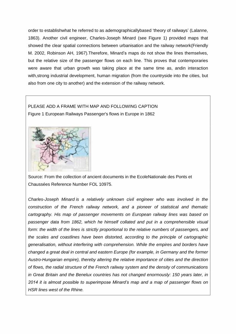
PLEASE ADD A FRAME WITH MAP AND FOLLOWING CAPTION
Figure 1 European Railways Passenger's flows in Europe in 1862
Source: From the collection of ancient documents in the EcoleNationale des Ponts et
Chaussées Reference Number FOL 10975.
Charles-Joseph Minard is a relatively unknown civil engineer who was involved in the
construction of the French railway network, and a pioneer of statistical and thematic
cartography. His map of passenger movements on European railway lines was based on
passenger data from 1862, which he himself collated and put in a comprehensible visual
form: the width of the lines is strictly proportional to the relative numbers of passengers, and
the scales and coastlines have been distorted, according to the principle of cartographic
generalisation, without interfering with comprehension. While the empires and borders have
changed a great deal in central and eastern Europe (for example, in Germany and the former
Austro-Hungarian empire), thereby altering the relative importance of cities and the direction
of flows, the radial structure of the French railway system and the density of communications
in Great Britain and the Benelux countries has not changed enormously: 150 years later, in
2014 it is almost possible to superimpose Minard’s map and a map of passenger flows on
HSR lines west of the Rhine.
1.2. When the railway network and the network of cities form a single entity: territorial
modelsand regional typologies on the threshold of the 1960s
If we now move a century forward, to the time during which Pierre Georgemade his
statement, the point at issue was not so much to build new lines, as the European network
was considered to be ‘mature’, but to modernise the railway system in order to adapt to a
new economic and demographic situation.The rural exodus was petering out, and cities were
diversifying their industrial and service bases. Consequently,Pierre Georgemeant something
different by the term ‘urban growth’thanLalanne orMinard did. He was no longer attempting to
optimise the design of the network in relation to a given pattern of human settlement, nor was
he seeking to provide the best possible services between mining areas and industrial centres.
In the 1960s, the car was already providing stiff competition for passenger rail services, and
lorries were transporting a growing proportion of freight traffic. Consequently,what was at
stakein the interaction between railways and demographic change was regional planning.
The idea was to allow the rail system to give structure toan efficient network of cities that
would act as regional centres, create growth and attract a young, qualified and skilled
workforce.
Pierre George’s research was therefore concerned with the link between demographic
change, the network of cities and the railway system,with a view to creatingan ‘urban
backbone’that would fulfil the role of wealth creation with varying degrees of success (Juillard,
1971).This research was very much influenced by an updated form of central place theory
that was known by the name of ‘regional science’, and which generated models that
explained the effects of the network on the urban system and human settlement.Among the
research conducted during this period, studies that examined‘the demography of railway
networks’ (Chatelain, 1947)highlighted the success of some cities and the failure of others as
a result of traffic conditions, service frequencies, passenger numbers and the economic
specialisation of different areas.
1.3. High-speed rail’s re-organisation of the network of cities
There was something of a hiatus in scientific output between the 1960s and the advent of a
third phase of research, which went together with the third age of the train, namely high-
speed rail (HSR),and the third urban age, that of the globalised metropolis (Claval, 2000). In
this new phase, the shortening of journey times, the deindustrialisation of cities, the digital
revolution and the globalisation of the economy workedtogether with demographic

changesand, for a number of reasons, led to the adoption of a radically different approach to
the issue. First, the high-speed network marked out some parts of the country from the
remaining network of cities, thereby creating preferential accessibility conditions between
(frequently large) cities and omitting those cities that lie between them(the so-called tunnel
effect) (Hall and Banister, 2013). HSR is also responsible for a change in commuting
patterns and leisure travel (Dieleman and Faludi, 1998).
Thus,the three historical phases we have proposed provide us with a useful analysis
framework, as they show the holistic nature of the human, urban and economic changes that
have gripped the European continent since the middle of the nineteenth century, and the way
in which rail can be seen as both a product of these changes, and a factor that has
accelerated them (Labasse, 1945). The train in itself has not directly set in motion or affected
any demographic events, nor triggeredexnihiloany processes of urbanisation, but it has
intensified or impeded broader mechanisms which, when analysed, reveal the singular
nature of the regional profiles in question. This also shows that the interactions involved are
highly diverse, as are the scientific approaches to their study,which depend on the nature
and goals of research and the socioeconomic context (Jensen and Richarson, 2007)
2.Retrospective analysis of the interactions between railways, human flows and
urbanisation from 1830s to the dawn of the 21st century
2.1. What is the point of a retrospective analysis?
Some readers may doubt the value of studying past interactions between demographic
change and railways. How, for example, does an explanation of the way the railway network
emptied the large agricultural estates of eastern Prussiahelp us understand the rail strategies
implemented today?In our view, operators frequently make the mistake of considering
demographic factors as an externality (Accenture, 2010), in the same terms as the main
environmental or energy-related issues. However, the history of the location of settlement is
an internality, as the railway network has been, to a large extent, inherited from earlier
phases of the interaction between settlement, geography and the economy. Comparing the
settlement modelin relation to models of the entire European railway network, and
considering with equanimity the issue of the ‘path dependency’generated by the excessive
provision of railways in the first half of the twentieth century may prove useful in making us
aware of issues that are very much of current concern (Merger and Polino, 2004).
2.2. What we know about the interactions between the rail network and settlement
Few studies haveanalysed demographic change and change in the rail network at European
level since the creation of the latter (Martí-Henneberg, 2013; O’Brien, 1983), which contrasts
with the situation relating tothe creation of each country’s network (Caron, 2005; Cobb, 2003;
del Río et al., 2008; Turnock, 1998; Schram, 1997; Silveira et al., 2011). Nevertheless,
irrespective of where the focus is placed, research in this area potentially targets two
different goals.The first is to discuss what rail owes to demography and what it does not; that
is,to seehow well, or how badly, the geographical distribution of the population matched the
railway infrastructure when it was designed. This field of research reveals the ‘over-
provision’or ‘under-provision’ ofrailways in different regions.
This type of work also allows us to discuss how important demographic factors are in the
creation of the networkin comparison with other criteria of a political, economic or
environmental nature. Railways have not always been built with reference to settlement, they
also have to fit in with the physical geography (the first lines could not climb steep gradients,
for example). Moreover, the network was created as the result of a set of decisions made by
the State and/or private companies that aimed to satisfy a wide range of political and
economic interests. Consequently, France and Spain built a radial network around the capital
by which a centralizing authority asserted itself. Other countries,such as the Netherlands
(Schmal, 2003), pursued a mercantile policy and designed a rail network that provided good
port/hinterland links.
The second direction for research into historical demography sets out to identify and
measure the effects of the railway on demographic concentration (Martí-Henneberg,
2005),urban growth and the hierarchy of cities.Several parameters are measured in this
context: the demographic impact of rail as a result of population displacement (attraction,
concentration, the structuring of space around stations, and the creation of rail
hubs 2 ).Studies are generally concerned with functional changes in the focal city and
modification of the relationship between it and other cities, as a result of changes in its size
or rank in the urban pyramid of the region. In this area, researchers have revealed the effects
of demographic thresholds in terms of both density and city size.3
2 An in-depth study of this topic has been conducted in Wales (Gregory andMartí-Henneberg, 2011)
Also of note is Felis-Rota, Martí-Henneberg and Mojica(2012). 3Denise Pumain(1982) researched the spread of railways and the urban hierarchy in France between
1831 and 1911. Although urban growth was contemporary with the creation of the network, she detailed the correlations between the position of cities in the hierarchy (the rank-size rule), the way
2.3. Rail and the growth of cities: some convincing statistical demonstrations
The findings of this interdisciplinary research, which combines history, demography and
spatial analysis (Martí-Henneberg2008),clearly reveal the role played by rail networks in
urban growth and highlight the influence of demographic changes on the development of
railways.
The research generates three findings. First, railways tend to encourage geographical
concentration, which leads to very major changes in the structure and hierarchy of the
network of cities (Mojica and Martí-Henneberg, 2011). Railways primarily acted as a stimulus
to the cities that were served early on, were located at junctions, and had populations of
more than 10,000 inhabitants. However, a disaggregate analysis of the demographic
variables casts doubt on the commonly held view that the railways hastened rural
depopulation and the decline of village communities. As Schwartz et al. (2011b) explained‘it
is more the case that rail gave a second chance to rural communities with stable or restricted
growth and opened up new cultural and economic horizons for them (for their agriculture, for
the export of raw materials, and for timber or firewood)’[page 55]This being so, locations that
could not be accessed by train became increasingly marginalised, so that rail did tend to
exacerbate geographical inequalities. Finally, recent research has explained that line
closures (from the beginning of the twentieth century) did not result in a general reduction in
accessibility because the population was becoming concentrated in larger centres that
retained their access to the network.
2.4. Rail and migration: railways as one factor of rural desertification
Another important topic is the link between the existence of the railway and urban–rural
migration. The layman’s view is that the railway, whose arrival coincided with the large-scale
rural exodus, accentuated the process; however, thorough research involving geographically
weighted regression4shows the contrary. In reality, the more the accessibility of the rural
zone by railway increased, the more net migration tended to fall. In France,the migratory
dynamic was highly dependent on the station density of the canton and its distance from the
they are integrated with the network and the intensity of their growth. Her research shows the importance of the threshold of 10,000 inhabitants:‘The larger the city, and the earlier the railway arrived there, the more important it became as a rail hub and the greater its growth’(p. 539). This work also shows that being positioned at the terminus or a junction is more advantageous than being simply an intermediate station. 4 Geographically weighted regression (GWR) is an extension of a classical regression method that
describes the relation between net migration and one or more explanatory factors. However, while regression produces an estimate of the relation between the variables in the entire study zone, GWR produces a set of estimates derived from the study of spatial units that are adjacent to each other. Thus, instead of giving a single, mean, result GWR produces an estimate of this relation for each spatial unit and shows the geographical variation between the variable and its explanatory factors.
urban centre. 5 Railways explain approximately 40 per centof migration, and statistical
regression shows a wide range of interactions between demographic change, accessibility by
rail, and the rural environment.
We therefore refer the reader to a large body of recently published research (Morillas,
2012)which emphasises that many methodological difficulties still remain:the availability of
data, the stability of municipal boundaries and the historical continuity of statistical series all
needattention in order to enhance the general quality of the databases (Siebert, 2004). The
explanatory power of the regressions between demographic and railway data seem to be
stronger during the periods when the network was being built and when major human
migrations took place (generally, between 1860 and the 1920s) (Martí-Henneberg, 2011).In
addition, few studies have examined the redrawing of national boundaries, the reconstruction
of the network and the movements of populations (or peoples) that occurred in the aftermath
of the Second World War (Carter, 1952; Mellor, 1992).
3. Demographic changes and the efficiency of European railways
3.1. A caveat: the importance of not confusing demographic projection and long-term
forecasting
Let us now turn to the present. Much research has examined the effects of demographic and
sociological change on the railway system, but little of this exploits all of the available
data.Nevertheless, there are harmonised databases that use a fine-grained spatial scale (at
municipal level with global coverage, as in the case of the work performed by Denise Pumain
and FrançoisMoriconiEbrard(1997). These allow us to build spatial models of changes in the
total population size and make demographic projections on the assumption that observed
trends will continueinto the present and the medium-term,and provide information on the
processes in question for the next 30 years or so. This data gives a general idea of the
number of people who will be living in a given area. Theprojections highlight Europe’s low
overall demographic growth, and even a clear reduction in the total population, which is
obviously unfavourable for the demand for passenger rail transport. Such projections are
based on the continuation of the observed trend in the rate of natural increase (the birth rate
minus the death rate),and a set of assumptions regarding the arrival of immigrants from
outside Europe to make up the natural deficit.
5‘Multiple regression analysis shows that 31 per cent of the variation in the rate of growth between
1831 and 1911 depended on the importance of the city’s railway junction, the date of the arrival of the
railway and the city’s size at that date’ (Pumain 1982, pp. 539).

Demographic projections extend dynamics that already exist,without adding new factors.
However, they are based on assumptions about the net migration rate, which means that the
process is effectively one of forecasting – that is,based on conjectures, which are often
linked together to form contrasting narratives or scenarios. The future of railways necessarily
involves both projections and scenarios: it requires us to make a forecast about migration,
which is a topic that is obviously highly politically sensitive. Moreover, it requires us to work
from demographic projections and to enrich these with socioeconomic characteristics: the
propensity of future generations to travel, and the extent to which lifestyles will be mobile or
immobile, which is in the domain of pure forecasting. Thus, in spite of the apparent freedom
the forecasting narrative allows, such work tends to focus on the 27-member European
Union,and rarely considersthe space formed by Europe and its neighbours (Banister and
Givoni, 2013).It consequently remains very cautious on the topic of future migration.
3.2. Demographic change and rail forecasting: benefits and limitations of some
scenarios
We have already mentioned the considerable uncertainty that reigns with regard to the ways
in which societies and individuals may adapt to new demographic situations. However, we
have no alternative but to try to link these masses of data, which are heterogeneous for the
systems-dependent reasons described in the first section: the major models of mobility are
influenced by the general economic climate and other major political (the distribution of
wealth) and environmental (energy and climate) challenges.
The discipline of geographical forecasting, which is currently gaining prominence, occupies
the middle ground between scienceand decision-making support for rail operators, and is
responsible for two types of overarching narrative (Crozet, 2009). The first is the idea of
‘contented mobility’:in this scenario, Europe will open up its metropolises to a wave of
immigration that will have the potential to mitigate the effects of population ageing on the jobs
market and repopulate rural zones.The intensive use of high-speed transport systems
(Gutiérrez et al., 1996)is essential for this scenario, as high-speed corridors, which will have
become transnational, will connect capital cities and compete successfully with air transport,
whose fuel will have become too expensive (Gutiérrez, 2001). Some lines will carry
businessmen between banking and administrative centres, while others will carry tourists and
individuals engaging in leisure activities, which will no longer be seasonal butde-
synchronised.Some groups will even manage to ‘live within the flows’ (Cattan, Frétigny,
2012)and, using new technologies, construct their family lives and interpersonal relations

around multiple homes, activities and national affiliations.For these individuals, the new hubs
will be intermodal metropolitan stations containing a series of high-value-added business
services, connected work areas and luxury hotels.
The other view, which provides a counterpoint to the first, is that of an ageing, impoverished
Europe with ever-decreasing levels of mobility (Hoedemaeker2013; Harper, 2007). This is
founded on the rapid increase in the percentage of the population aged over 65 years (30 per
cent in 2060, compared with 17 per centtoday), the pandemic of obesity, which raises doubts
about an increase in life expectancy in good health, increasing solitude and social
fragmentation, lacklustre long-term economic growth, rising energy prices, the
impoverishment of lower- and middle-income groups, and youth unemployment (Tetraplan
A/S Copenhagen, 2007). These factors will combine to lower the total number of trips, as
well as leading to a continuous and silent drop in the number of people going away on
holiday,as has already been apparent for almost a decade (Schäfer, 2006). This scenario will
have an impact on railway traffic by reducing the number of journeys and the profitability of
railway undertakings, which become unable to adequately finance network maintenance.
We have no need to choose between these two meta-scenarios,as they are, above all,
political in nature, and as such are simply intended to elicit reactions (Givoni, 2006).
Essentially, these scenarios apply everywhere and are a-spatial, and, unlike those we shall
describe below, take little account of concrete local factors and geographical differentiation.
3.3. Demographic change and railway performance: a regional typology
A second way of approaching the interaction between demographic forecasting and the
performance of the railway system is to use spatial modelling (Kunz and Buiter, 2010). The
principle here involves using geographical images to help us understandthis interaction. The
images are produced not only by display systems that represent ‘big data’ but also narratives
based on the statements of experts and varied conjectures.This type of approach allows us
to identify three distinct geographical cases that are, to varying degrees,compatible with
railway connectivity and accessibility.
AsEllwangerandGoerger (2001) explained,‘high speed rail would be able to cope extremely
well with a non-uniform reduction in density, with dense zones separated by deserted
areas’[page 140].This quotation from a UIC study brings us to our first case, that of the
enormous urbanised corridor that stretches from Italy to the Rhineland and contains the
world’s highest population densities, the most integrated metropolitan archipelagos and the
highest density of railway lines, both per hectare and per thousand of the population.

ThisEuropean ‘heartland’ is made up of a set of economically integrated (Euro zone)
metropolisesthat are connected together within a robust HSR system with regular services.
The challenges facing this heartland are to forecast increases in traffic, and to modernise in
order to be able to cope with mass transit flows (Grasland et al., 2001).The fact that it is
impossible for these urban mega-regions to become more urbanised is rarely mentioned
(Belgium already has an urbanisation rate of 98 per cent (Vanoutrive et al., 2012)).In addition,
this heartland contains the regions of Europe that will suffer the most from net population
decline due to low fertility.
This central area is marked out from a system of marginal zones with distance-related
gradation,and the presence of mountain and maritime barriers. The inner marginal zones
consist of archipelagos of medium-sized cities, which often receive little in the way of
demographic and economic stimulation, for which the efficiency of railways has been brought
into question (Taylor, 2005).The outermarginal zonescorrespond to non-metropolised rural
regions, where the presence of railways is either a historical relic or the outcome of the need
to travel through the area or change trains. The areas that contain cities are frequently
located in a circle around the Rhineland (the north-eastern part of France, the Polish plain,
and the Czech and Hungarian systems of cities (Kosinski-Leszek, 1971)),while the rural
marginal zonesare largely empty and provide a location fortranscontinental routes (Portugal–
Ukraine, Ireland–Mezzogiorno, the Baltic–Black Sea, etc.).
The influence of the centre-periphery model is evident in this research, from which one main
factoremerges: the central position of the re-unified Germany (Buckwalter, 2005), the
combination of its industrial and demographic power, the importance of its railways and the
implementation of a model that is both centralised (a radial network around Berlin) and
polycentric cities regularly dispalyed in a distance of an hour away from one another by train).
Germany is also the heart of european railway system thanks to the grid structure of its
network, with lines running east–west (from the northern range ports to Poland and Russia
(Friebel et al., 2007)) and north–south (from Scandinavia to the Mediterranean through the
Swiss and Austrian tunnels). These cartographic exercises demonstrate the real advantages
that stem from a central position, but they run counter with other analyses that show the
concentration of the population in the margins of Europe along the Atlantic and
Mediterranean coastal corridors,which is in keeping with the globalisation of the economy
and the emergence of city-state port models that are fully integrated within financial flows.6
6 This internal segmentation of the national rail system means that it is difficult to picture the overall
competitiveness of a national railway network (see Haywood, 2007; Lapsley,1984).

3.4.Sociodemographic variables and railway performance indicators
Apart from these spatial typologies, which are clearly highly dependent on systems
ofrepresentation, there are a certain number of studies (Ellwanger and Georger, 2001)that
use demographic indicators to construct railway-performance models. These demographic
indicators are not disconnected from the other key indicators of the profitability of railway
companies, and always involve the four vital factors of low interest rates, improved services,
acceptable rail access charges and dynamic demand (Beck et al., 2013). However, if we look
uniquely at demographics, the trends that are identified are double-edged. These trends
have the potential either to encourage or discourage general levels of travel, the use of
railways (for intercity travel and in Metropolitan zones) and HSR (Francisco and Martí-
Henneberg, 2009).
On one hand, considering the lengthening of life in good health provides us with between
150 and 200 million travellers who could potentially use the train for their work-related and
leisure trips. These cohorts, who are already alive, are used to travelling, but are also used to
cars and using air travel for tourism. It is reasonable to suggest that providing services (in
terms of locations, times and pricing) that suit the lifestyles of these people will encourage
them to travel by train. Furthermore, we can assume that energy constraints will foster
environmentally friendly travel strategies that will include metropolitan, intercity and HSR
travel. The growth in tourist flows to European destinations, in particular from emerging
countries, is another potential source of rail passengers, with the future number of
international visitors estimated at 800 million (twice today’s level)(UNWTO, 2010).
There are of course other demographic factors that are less favourable to the increase in
travel in general, and railway travel and high-speed travel in particular. The value of this type
of exercise is to discuss the way in which demography combines with performance indicators
(Hooghiemstra et al., 1999) such as capacity and locations served, speeds and time savings,
punctuality, the travel environment and the quality of the experience, additional commercial
services, etc. (Beck et al., 2013).Thus, a given factor is not in itself either positive or
negative,but rather is part of a strategic approach. Let us consider the example of the
desynchronisation of working hoursand the rhythms of work and leisure. This factor appears
to be favourable to the train. At the present time, the success of HSR depends on two
contrasting types of use: business trips between Monday and Thursday and leisure trips at
weekends. Interaction between the two travel purposes and their spread over the entire week
has the potential either to increase passenger load factors or create friction (caused by one
type of passenger interfering with the other, inappropriate fares, provision of incompatible
services, etc.),which will reduce the quality of service (Caldas de Castro, 2007).
Conclusion and outlook
This chapter shows the value of taking into account the European level when attempting to
understand the links between railways, settlement and urban growth. A number of key ideas
emerge from this exercise. First, these links were built up over a long period of time, and they
have not only shaped a considerable diversity of geographical systems, but also constructed
very powerful representations that still have a strong influence on debates on the efficiency
of rail transport. Next, we have shown that the interaction between railways and demographic
change is extremely dynamic, as the two have evolved together over decades, with periods
of rapid readjustment and differences in both the chronology and nature of changes between
one country or one region and another.Finally, knowledge about the future is vital for the rail
sector, as it takes approximately 10 years to introduce new rolling stock and at least 20 to
design and build a high speed line.In spite of its faults and weaknesses, we therefore still
need forecasting (De Palma et al., 2010).However, it must be improved in two respects:first,
greater transparency is required with regard to the construction and handling of the
fundamental indicators and variables; andsecond, experts need to make greater use of
geographic information systems in models that analyse the performance, vulnerability and
resilience of the railway system (Tschopp et al., 2003) in order to promote a more
geographicallybased approach.
References
Banister D. andGivoni, M.(2013), ‘High speed rail in the EU 27: trends, time, accessibility and
principles’, Built Environment, 39 (3), 324-323.
Banister, D. and Hall. P. (1993), ‘The age of the train’,Built Environment,19 (34), 156-162.
Beck,A., Bente,H. and Schilling,M. (2013),Railway Efficiency, Discussion Paper,International Transport Forum, 2-4 May 2012 Leipzig
BuckwalterD.W. (2005), ‘Transportation regions and the eastward integration of Europe’,
TijdschriftvoorEconomische en SocialeGeografie,,96 (1), 31–47.
Caldas de Castro, M. (2007), ‘Spatial demography: an opportunity to improve policy making
at diverse decision levels’, Population Research and Policy Review,26 (5/6), 477-509.

Caron, F. (2005), Histoire des chemins de fer en France. Paris: Fayard.
Carter J.P. (1952), ‘The German railways an analysis of economic adaptation’, Land
economics, 28 (4), 307–317.
CattanN. andFrétignyJ-B.(2011), ‘Les portesd’entrée de la France et les systèmesterritoriaux
de flux,des systèmesspatiaux en prospective’,Territoires 2040, La Documentation
française DATAR,4,67–84.
Chatelain,A. (1947), ‘Démogéographie du grand troncferrésud-est (Paris-Lyon-
Méditerranée)’Les Étudesrhodaniennes.,22(1-4), 35-82.
Claval, P. (2000), ‘The European system of capital cities’,GeoJournal,,51 (1/2), 73-81.
Cobb, M.H. (2003),The Railways of Great Britain: A Historical Atlas. Cambridge: Cambridge
University Press.
Crozet, Y.(2009), The Prospects for Inter-Urban Travel Demand: Three scenario families for
inter-urban mobility in France to 2050, discussion paper No. 2009, 14 December, Joint
Transport Research CentreMadrid.
De Palma, A., Proost, S. and Van der Loo, S. (2010),‘Assessing transport investments –
towards a multi-purpose tool’,Transportation ResearchPart B,44, 834–849.
del Río,E., Martí-Henneberg, J. andValentín, A.(2008), ‘La evolución de la red ferroviaria en
el ReinoUnido (1825–2000)’,SegonCongrésCatalà de Geografia, 29–31.
Dieleman, F.M. andFaludi, A. (1998), ‘Polynucleated metropolitan regions in Northwest
Europe’,European Planning Studies,6 (4), 365-375.
European Union, DG TREN, 2009, Un avenir durable pour les Transports vers un
systèmeintégré, convivial et fondésur la technologie, 17 juin 2009, Brussels.
www.cre.org/img/uploads/piecejointe/filename/CEMR_future_of_transport_FR.pdf
consulted june 30th 2014.
Ellwanger, G. andGeorger O. (2001), ‘The impact of social and demographic changes on
transport demand in Europe in the year 2030’,Rail International, Association
Internationale du Congrès des Chemins de Fer (AICCF), 6 (6-7), 139-147.
Felis-Rota, M.,MartíHenneberg, J. and Mojica, L.(2012), ‘A GIS analysis of the evolution of
the railway network and population densities in England and Wales, 1851-2000’, EHA
2012 Annual Meeting, Vancouver, Canada, 21–23 September.
Friebel, G.,Guriev, S., Pittman, R.,Shevyakova, E. andTomová, A. (2007), ‘Railroad
restructuring in Russia and Central and Eastern Europe: one solution for all problems?’,
Transport Review,27 (3), 251–271.
Friendly, M., 2002, ‘Visions and re-visions of Charles Joseph Minard’, Journal of educational and behavioralstatistics, 27, 1, 31-51. George, P.(1968), ‘Chemin de fer et développementurbain’, in CHF Commission
d'HydrologieFluviale, Mélanges offerts à Maurice Pardé, Editions Ophrys, pp. 229-237.
Givoni, M. (2006),‘Speed rail: catalyst for european integration?’Transport Reviews26 (5),
593–612.
Grasland, C.,Peyrony, J. andPumain, D.(2001), Study Programme on European Spatial
Planning, Final Report, BundesamtfürBauwesen und Raumordnung (BBR)
Forschungen, Heft 103.2, accessed 31/05/2014 at
http://www.nordregio.se/spespn/welcome.htm.
Gregory I. andMartí-Henneberg,J. (2011), ‘The railways, urbanization, and local demography
in England and Wales, 1825-1911’, Social Science History(Summer), 34, 2, 199–228.
Gutiérrez, J. (2001),‘Location, economic potential and daily accessibility: an analysis of the
accessibility impact of the high-speed line Madrid–Barcelona–French border’,Journal of
Transport Geography9, 229–242.
Gutiérrez, J., González, R. and Gómez, G. (1996),‘The European high-speed train network,
predicted effects on accessibility patterns’,Journal of Transport Geography4, 227–
238.
Hall, P. and Banister, D.(2013), ‘High speed rail: Shrinking spaces, shaping places’, Built
Environment, 39 (3), 321-323.
Harper S.(2007), The Implications of an Ageing Population for the Railway :Scoping
Research on Ageing for Passengers and the Railway Workforce, Rail Safety and
Standards Board Ltd. 2008 research programme, London, March 2008.
Haywood, R. (2007),‘Britain’s national railway network: fit for purpose in the 21st
century?’Journal of Transport Geography15, 198–216.
Hoedemaeker,M. 2013, Future mobility scenarios for older people 2020 to 2050, in Last
report of the Project GOAL Transports needs for an ageing society, Vienna, september
30th 2013, consulted the 30/06/2014 at www;goal-project.eu
Hooghiemstra, J.S., Kroon, L.G., Odijk,M.A., Salomon, M. andZwaneveld,P.J. (1999),
‘Decision support systems support the search for win-win solutions in railway network
design’, Interfaces,,29 (2),15-32.
Jensen, A. andRicharson, T.(2007), ‘New region, new story: imagining mobile subjects in
transnational space’, Space and Polity,,11 (2), 137–150.
Juillard, E. (1971)‘Croissanceurbaine et accessibilité des villes’, Revue de Géographie de
l'Est, 3-4, (43), 231-245.
KosinskiLeszek A. (1971), ‘Geography of population settlements in East Central Europe’,
Annals of the Association of American Geographers, 61 (3), 599-615.
Kunz, A. andBuiter, H. (2010),‘Digital atlas on European Communications and Transport
European Communications and Transport Infrastructures: Performance and Potentials,
1825–2000, A Digital Atlas’, accessed on may 30th 2014 at: http://www.atlas-infra.eu.
Labasse, J.(1945), ‘Chemin de fer et Urbanisme’, Les Étudesrhodaniennes,,20(1-2), 121-123.
Lalanne, L.(1863), ‘Essaid’unethéorie des réseaux de chemins de ferfondéesurl’observation
des faits et sur les loisprimordiales qui président au groupement des populations’,
Comptesrendushebdomadaires de l'Académie des Sciences, 50, 206-210.
Lapsley,I. (1984), ‘Reconstructing British Rail: in search of a profitable railway’,Managerial
and Decision Economics,,5 (1), 32-48.
Martí-Henneberg, J. (2005), ‘Empirical evidence of regional population concentration in
Europe (1870–2000)’ Population. Space and Place 11, 269–281.
Martí-Henneberg, J,. 2008, ‘European Science Foundation initiative (Eurocores) project‘Water, Road and Rail: The Development of European Waterways, Road and Rail Infrastructures: A Geographical Information System for the History of European Integration (1825–2005)’ http://web.udl.es/dept/geosoc/europa/in/presentacio.html’consultedjune 30th 2014.
Martí-Henneberg, J. (2011), ‘Geographical information systems and the study of
history’,Journal of Interdisciplinary History,42 (1), 1–13.
Martí-Henneberg, J. (2013), ‘European integration and national models for railway networks
(1840–2010)’, Journal of Transport Geography, 26, 126–138.
Mellor, R.(1992),’Railways and German Unification’Geography,,77 (3), 261-264.
Merger, M. and, Polino, M.-N. (Eds.), 20 (2004),COST 340.Towards a European Intermodal
Transport Network: Lessons from History. A Critical Bibliography. Paris: AHICF.
Mojica, L. andMartí-HennebergJ., ‘Railways and Population Distribution: France, Spain, and
Portugal, 1870–2000’,EHA 2012 Annual Meeting, Vancouver, Canada, September 21-
23.
Morillas, M. (2012), ‘Creation of a geo-spatial database to analyse railways in Europe (1830–
2010). A historical GIS approach’. Journal of Geographic Information Systems,4 (2),
176–187.
O’Brien, P.K. (1983),Railways and the Economic Development of Western Europe 1830–
1914. London: Macmillan.
Pumain, D.(1982), ‘Chemin de fer et croissanceurbaine en France au XIXe siècle’,Annales
de Géographie,507 (September-October),529-550.
Pumain, D., Moriconi-Ebrard, F., 1997, City size distributions and metropolisation,
GeoJounrla, 43, 4, 307-394.
Ribeill, G. 1986), ‘Au temps de la
révolutionferroviaire:L'utopiqueréseau’Cahier/GroupeRéseaux,5, 48-59.
Ribeill, G.(1989), ‘Lalanne et la théorie des réseaux de chemins de fer’ Flux, special issue,
45-56.
Robinson,A H. (1967), ‘The thematicmaps of Charles Joseph Minard’, Imago Mundi, The international Journal for the History of Cartography, 21, 1, 95-108.
Roth, R.(2003), ‘Interactions between railways and cities in nineteenth century Germany:
some case studies’, in Roth R. andPolino M.N., The City and the Railway in
Europe.Ashgate Editions,, Burlington, pp. 3-28.
Schäfer, V. (2006), ‘Long-term trends in global passenger mobility’, in National academy of
engineering, Frontiers of engineering,National Academies Press, Washington DC85-97
Schaeffer E., Pruvot A., (2010), Rail 2020, Accenture, Brussels, p. 3.
Schmal,H. (2003), ‘Cities and railways in the Netherlands between 1830 and 1860’, in Roth,
R. andPolino, M.N., The City and the Railway in Europe.Ashgate Editions, Burlington,
pp. 29-44.
Schnetzler,J. (1967), ‘Le chemin de fer et l'espacefrançais’,Revue de géographie de
Lyon.,42(1). 81-118.
Schram, A. (1997),Railways and the Formation of the Italian State in the Nineteenth Century.
Cambridge: Cambridge University Press.
Schwartz,R.M., Gregory,I.N. andMartí-Henneberg, J.(2011a), ‘History and GIS: railways,
population change, and agricultural development in late nineteenth century Wales’,
Journal of Interdisciplinary History,421 (Summer), 15–28.
Schwartz, R.M., Gregory, I.N. andThevenin, T. (2011b), ‘Spatial history: railways, uneven
development, and population change in France and Great Britain, 1850–1914’. Journal
of Interdisciplinary History,42 (1), 53–88.
Siebert, L. (2004), ‘Using GIS to map rail network history’. Journal of Transport History,25 (1),
84–104.
Silveira, L., Alves, D., Lima, N., Alcantara, A. andPuig, J. (2011), ‘Population and railways in
Portugal, 1801–1930’,Journal of Interdisciplinary History,42 (1), 29–52.
Steen Petersen, M.and Sessa, C. (coord.) (2007), ‘TRANSvisionsReport on Transport
Scenarios with a 20 and 40 Year Horizon’, Final Report, March 2009.Tetrapan,
Copenhaguen. Consulted on june 30th 2014, at
www.81.47.175.201/flagship/attachments/2009_02_transvisions_report.pdf
Tapiador FJ. and Martí-Henneberg, J. (2009), Stations: Potential economic impacts
of technological and organizational innovations in intermodal access to major
passenger terminals,International Transport Research Symposium, Discussion Paper
No. 2009-27, Madrid, November, 15th.
Taylor, Z. (2005), ‘Railway closures to passenger traffic in Poland and their social
consequences’, Journal of Transport Geography, 14, 135–151.
Tschopp, M.,Fröhlich, P. and Keller, K.W.A. (2003), ‘Accessibiltity, spatial organisation and
demography in Switzerland through 1920 to 2000: First Results’, Conference paper
STRC 2003 Session History & Policy, 3rd Swiss Transport Research Conference,
Monte Verità/Ascona,19–21 March.
Turnock, D. (1998),An Historical Geography of Railways in Great Britain and Ireland.
Aldershot: Ashgate.
UNWTO, United Nations World Tourism Organisation, 2010, World tourism Barometer,
Madrid, 8, 2, 64 p.
Vanoutrive,T., Van Malderen,L., Jourquin, B., Thomas, I.,Verhetsel, A. andWitlox, F.(2012),
‘Rail commuting to workplaces in Belgium: a multilevel approach’,International Journal
of Sustainable Transportation, 6, 67–87