murgold resources inc. gogama, ontario vlp - …...41p12sw0071 a. 4888 chester 010 murgold resources...
TRANSCRIPT
41P12SW0071 a. 4888 CHESTER 010
MURGOLD RESOURCES INC.
Gogama, Ontario
VLP - E-M SURVEY
Report on Filtered Data
Norminex Limited
P. O. Box 2003
Sudbury, Ontario
December 1981
CONTENTS
Summary and Conclusions .*...*................*.........,
Recommendations ...*...................................... ii
Introduction ..*.*...*.........*.*..*......*.......*...... l
Field Work .............................................. l
Results of Field Work .................................... 2
Discussion of Results .........................*..*.*.*... 5
Interpretation of Results ..................*............. 7
References ...........4..*.....*..*................*.*.... 8
TABLES
Table I - VU? ~ E-M Crossovers
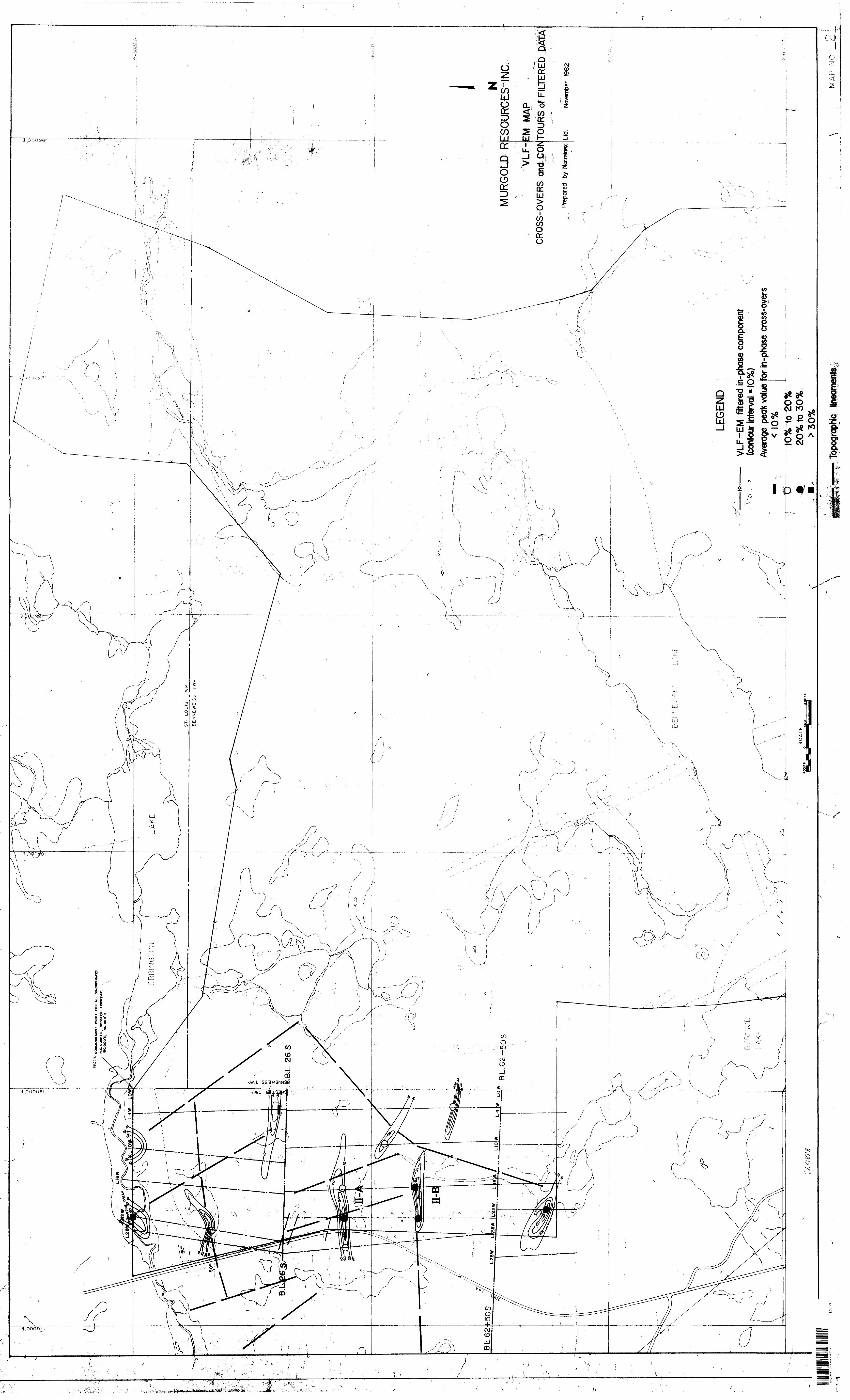
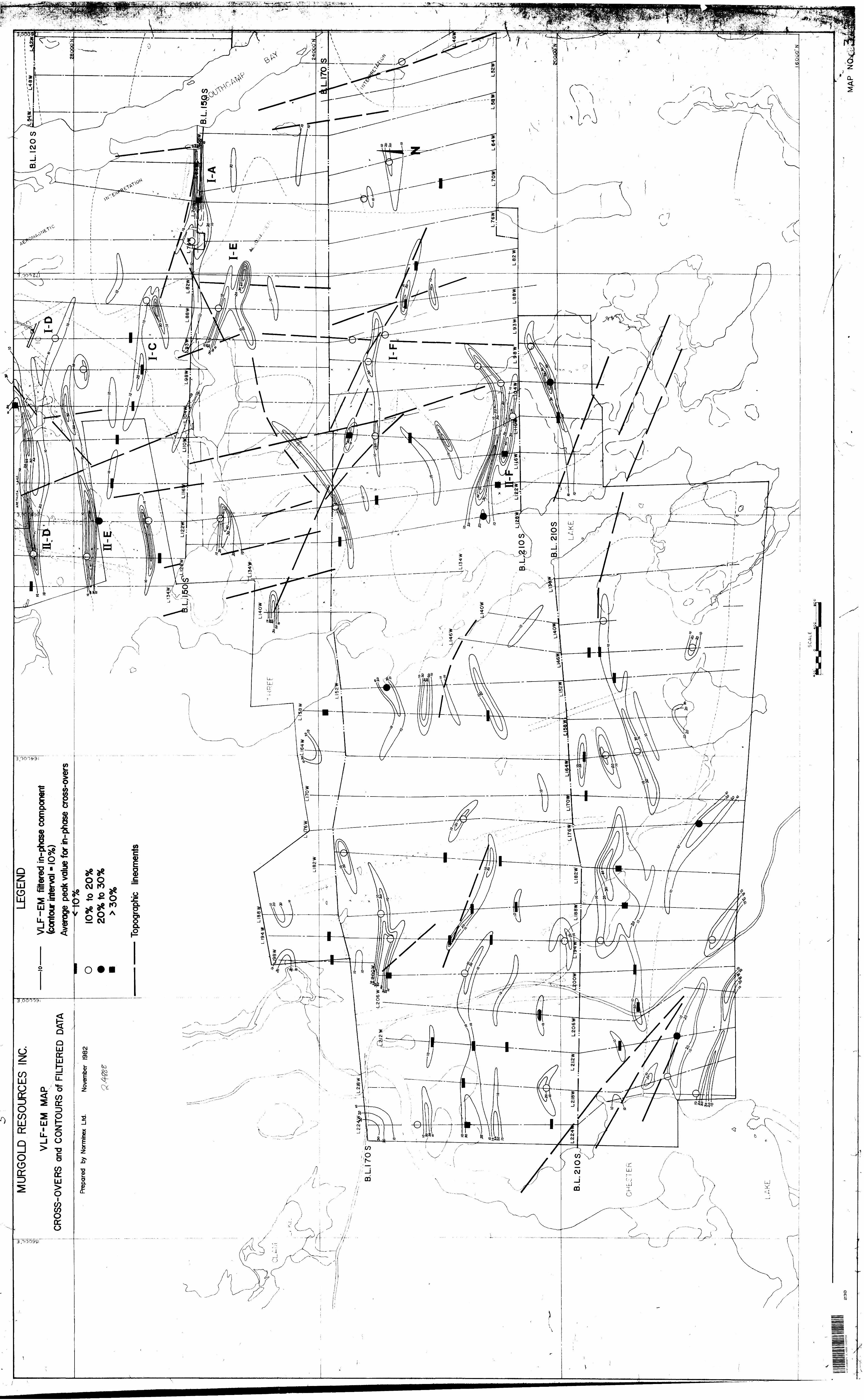
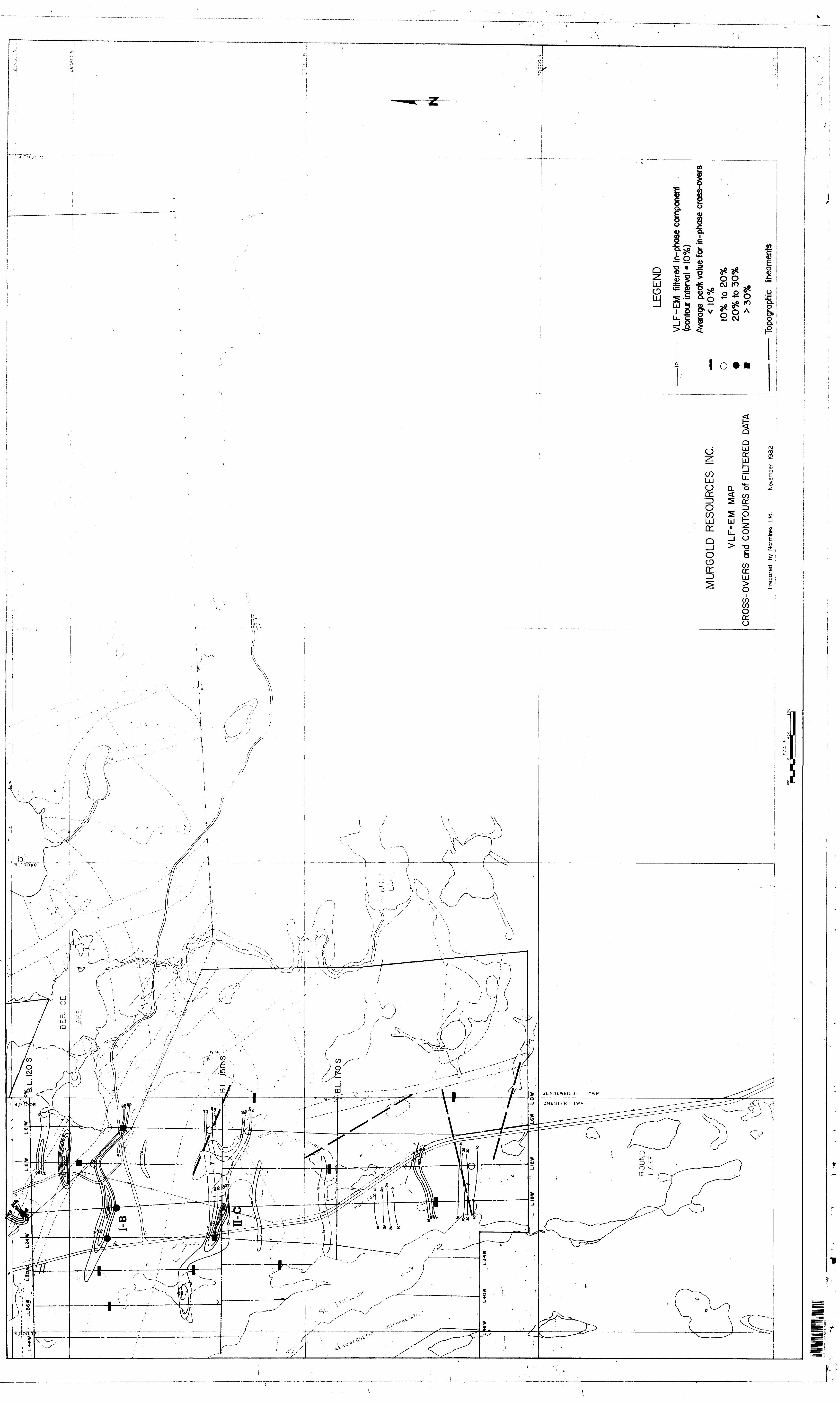
ILLUSTRATIONS
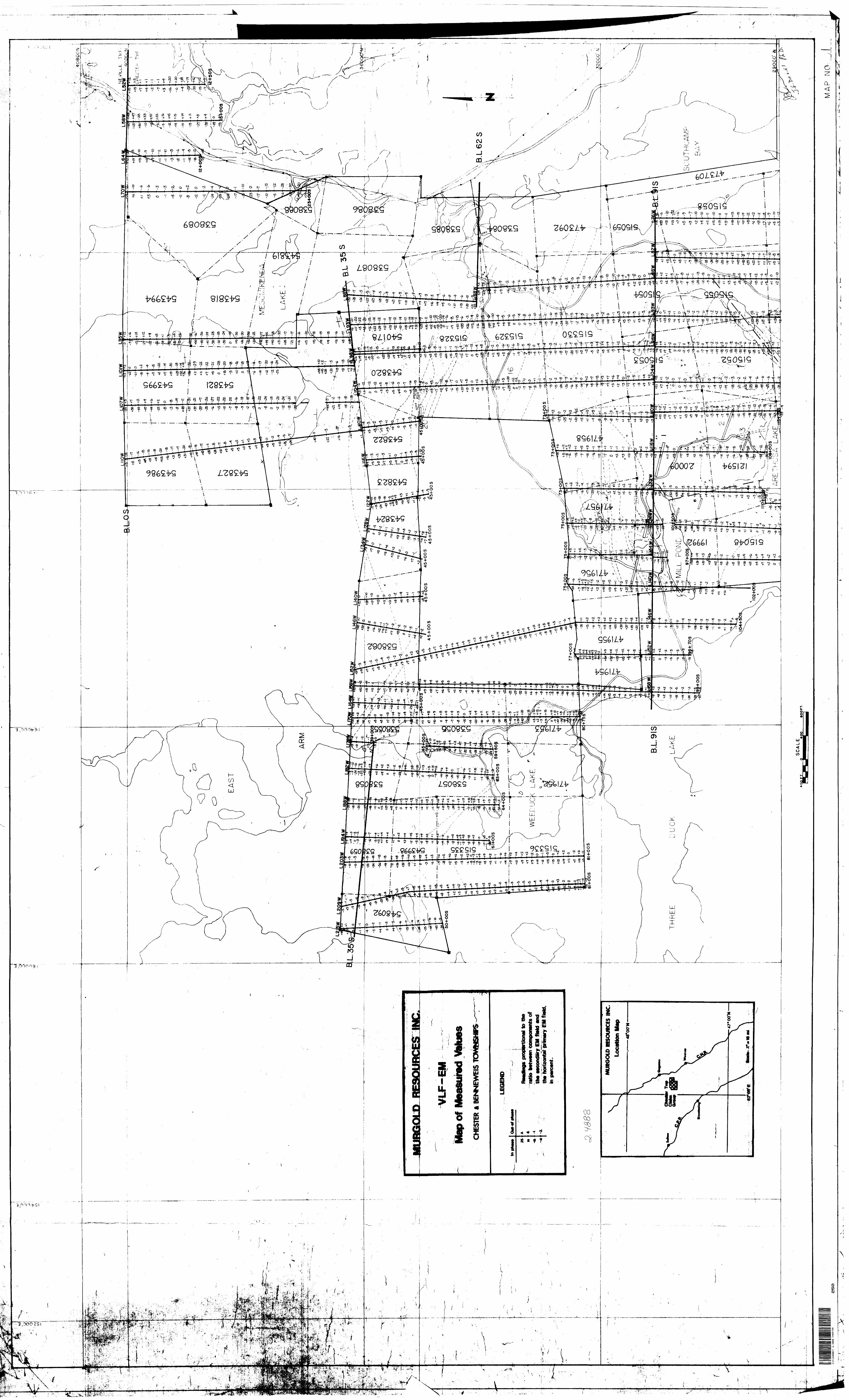
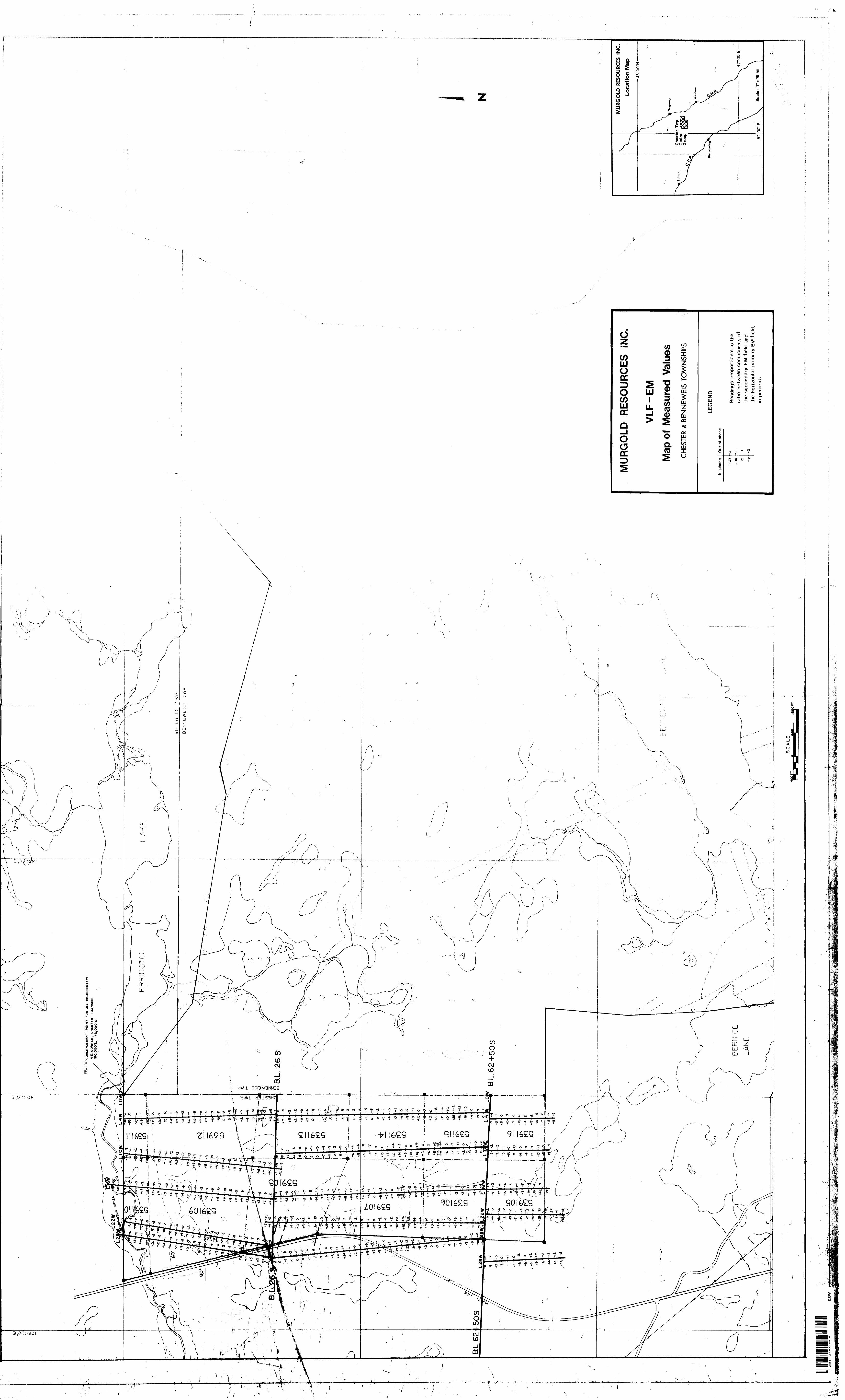
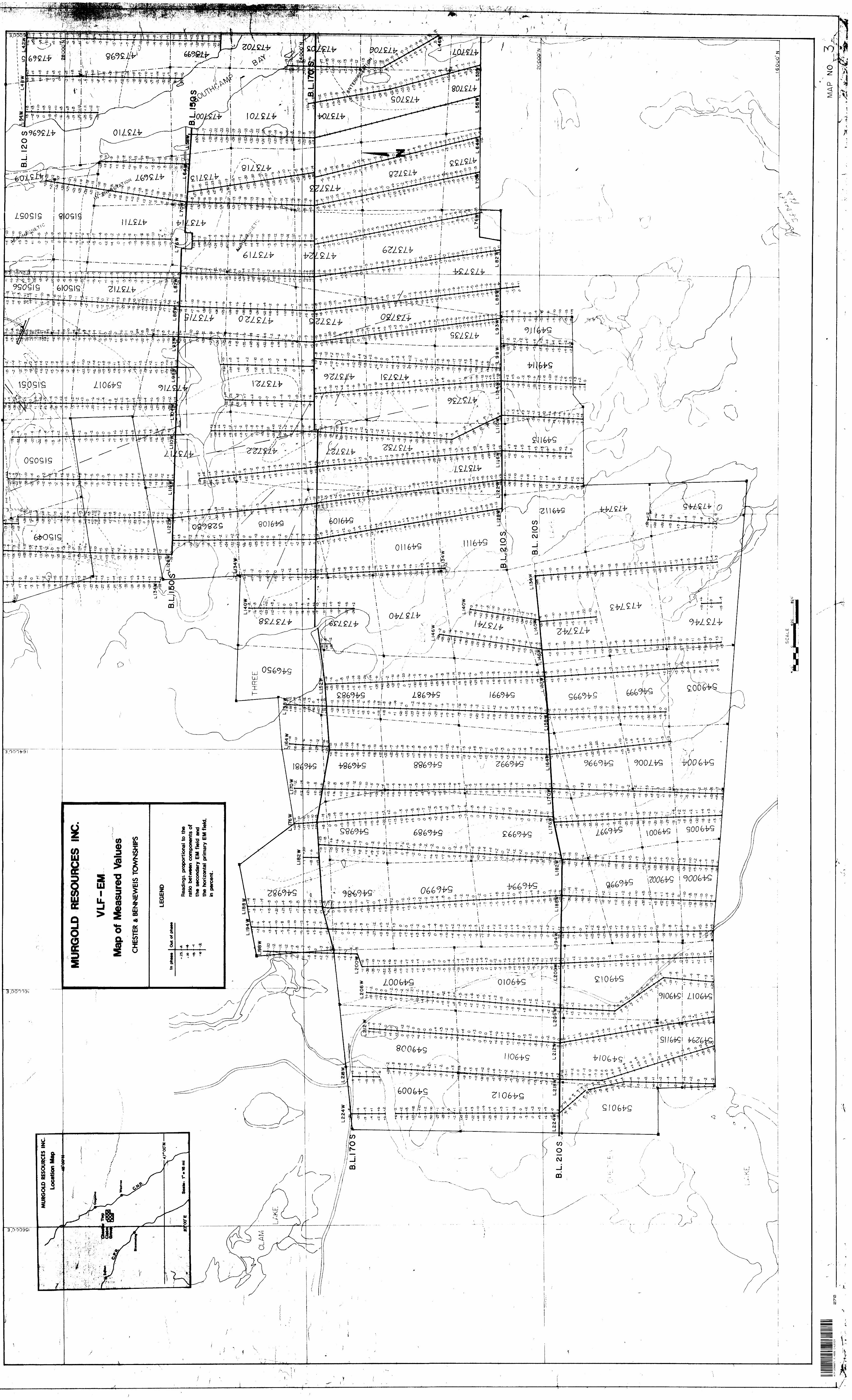
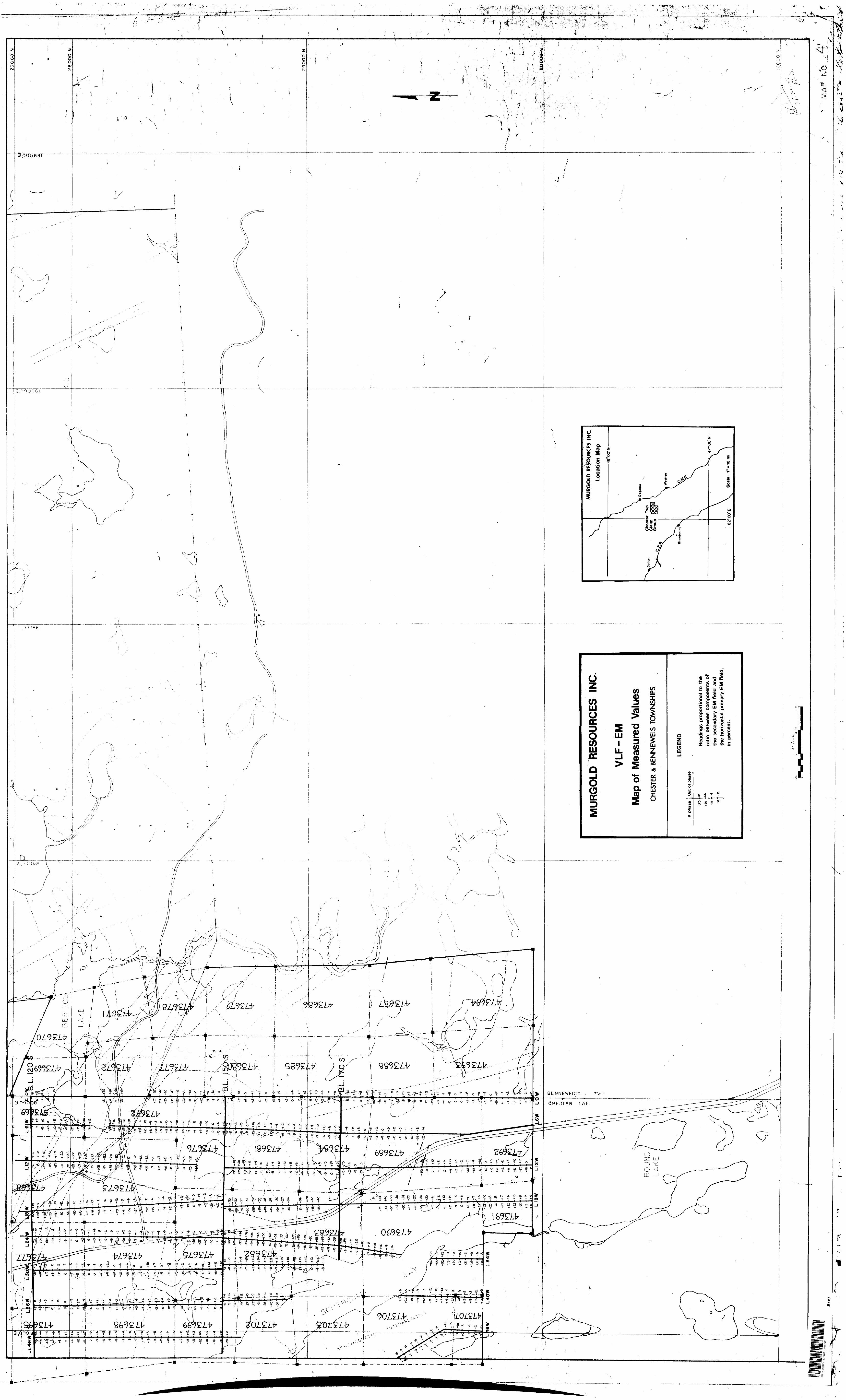
VLF - E-M Map - Cross-overs and contours of filtereddata (in pocket)
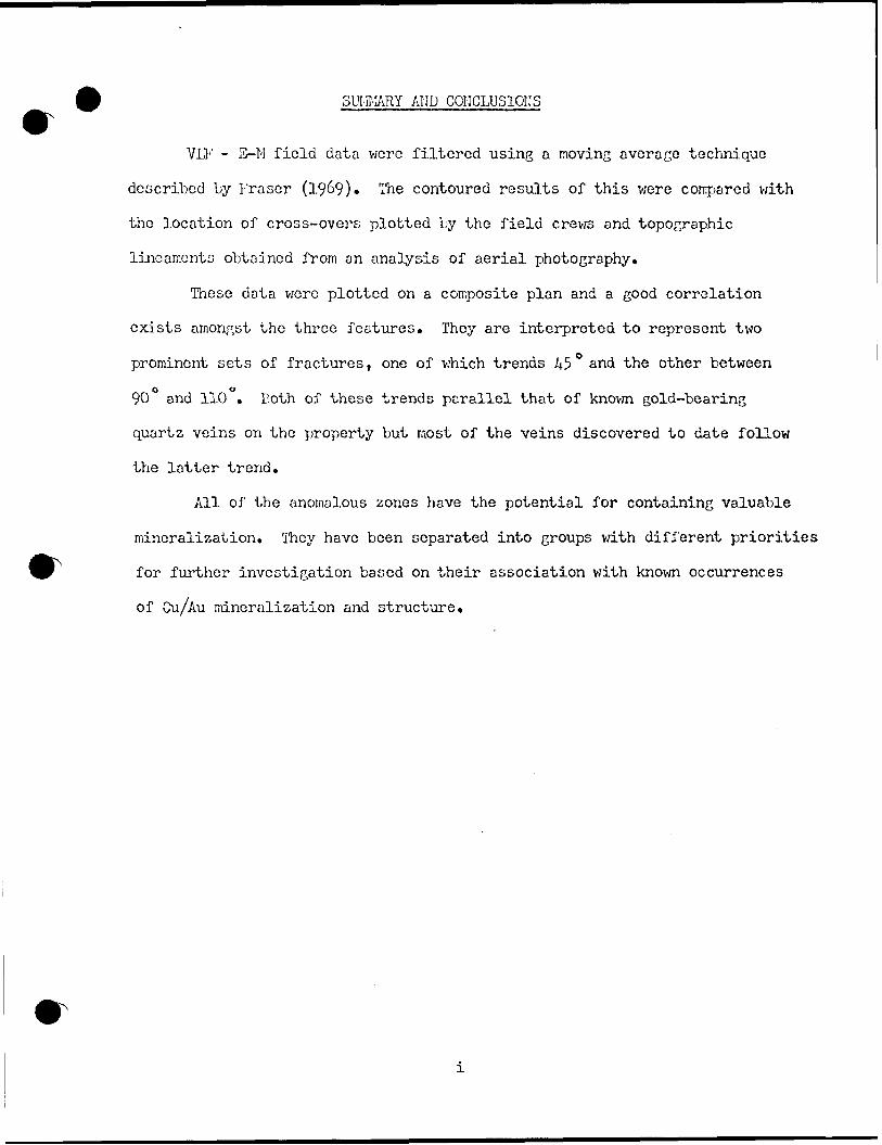
SUMMARY. AIID CONCLUSIONS
VLF - E-M field data were filtered using a moving average technique
described by Kraser (19&9). The contoured results of this v;ere compared with
the location of cross-overs plotted by the field crews and topographic
lineaments obtained from an analysis of aerial photography.
These data were plotted on a composite plan and a good correlation
exists amongst the three features. They are interpreted to represent two
prominent sets of fractures, one of which trends 45 0 and the other between
90 and 110 . Both of these trends parallel that of known gold-bearing
quartz veins on the property but most of the veins discovered to date follow
the latter trend.
All of the anomalous zones have the potential for containing valuable
mineralization. They have been separated into groups with different priorities
for further investigation based on their association with known occurrences
of Cu/Au mineralization and structure.
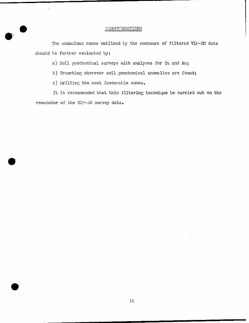
IHCOI'iKSNDATIONS
The anomalous aones outlined by the contours of filtered VLF-EM data
should bc further evaluated by:
a) Soil geochemical surveys with analyses for Cu and Au;
b) Trenching wherever soil .geochemical anomalies are found;
c) Drilling the most favourable zones.
It is recommended that this filtering technique be carried out on the
remainder of the VLF-SM survey data.
VLF - S-M SURVEY
Report on Filtered Data
Introduction
Ground geophysical surveys wsre carried out over the Murgold Resources
Inc. Claim group in Chester Township, Ontario during the summer of 1981*
Field work was supervised by R. Henning, P. Eng., Toronto.
An electromagnetic survey using the energy from very low frequency
radio transmitters (VLF - E-M) located in Seattle, Washington, (NLK) and
Cutler, Maine (NAA) formed a major part of this work. The survey was con
ducted using flagged lines oriented in a north-south direction approximately
600 feet apart and readings were taken at intervals of about 100 feet along
each line. The location of survey lines and stations was determined by pace
and compass. Measurements proportional to the in-phase and out-of-phase
components of the secondary electromagnetic field were made using an instrument
manufactured by Geonics Ltd., Toronto and'designated EK-16 (No. 16882).
Results of this survey were plotted as profiles along the traverse lines with
a horizontal scale of l inch = 400 feet and vertical scale of l inch - 40 f?.
Field Work
Measurements with the EM-16 were made using one or the other of the
two transmitter stations interchangeably. This practise has the advantage
that when one station ceases broadcasting the other one can often be used.
The primary electromagnetic fields from each station will have different
orientations, strengths and frequencies which will produce different responses
from a buried conductor. Consequently it is preferable to conduct a VLF-BK
survey using each transmitter for the entire survey. Fortunately, for the
Chester township survey the transmitter stations are almost diametrically
opposed and their broadcast frequencies are in the same order of magnitude.
The results of a survey using only one station probably would not be signific
antly different from those obtained in this survey.
Our evaluation of this survey is based upon an examination of the field
notes and profiles and the following assumptions:
a) The in-phase and out-of-phase components of the secondary electro
magnetic field were recorded as percentages of the primary field,
positive or negative.
b) For an operator traversing north and facing north, a positive in-
phase reading represents a southward dipping ellipse of polarization
and a negative reading represents a northward dipping one. For an
operator traversing south and facing south the reverse relationship
holds and a positive in-phase reading represents a northward dipping
polarization ellipse *
These data have been plotted by the. field crews as profiles along the
traverse lines. The relative position and length of many of these lines were
subsequently adjusted to lie within the known boundaries of the property.
Consequently, the location of cross-overs representing significant conditions
is only an approximation and should be checked.
Resul.ts| of Field Work
True cross overs indicating the presence of conductors were selected
from the field data using the assumptions stated above and are plotted on the
enclosed map. They are divided into four categories on the basis of the
average peak value for the in-phase component of the secondary electro
magnetic field. In general the larger the peak values the better the con
ductor and large values close together indicate a good conductor close to
surface. A large peak to peak separation along the traverse line indicates
either a broad conductor or a deeply buried one.
Those data representing the in-phase component of the secondary electro
magnetic field were filtered using a moving average technique described by
D. C. Fraser (1969). This produces another set of positive and negative
numbers such that the true cross-overs can be represented by the greatest
positive values. It is achieved by adopting the convention that the moving
average is conducted from north to south and that north dips of the polariz
ation ellipse are negative. It is.useful as another method for showing the
location and trend of conductors and it improves the resolution of anomalies
making them easier to recognize. The technique indicates anomalies at all
inflection points in the profile whether or not they cross over. Also,
different results are obtained by changing the length of interval averaged,
i.e. the sample spacing, so that care must be taken to select the one which
best portrays the anomalies in a given area. A spacing of 50 feet was
selected for this survey because it is suitable for defining conductors within
a few hundred feet of the surface (Fraser, 19&9).
The results of this analysis are listed in Table I and are shown on
the enclosed map. Anomalous zones are indicated by contours of averaged
values representing the in-phase component of the secondary electromagnetic
field where it is greater than ICXJo of the primary field.
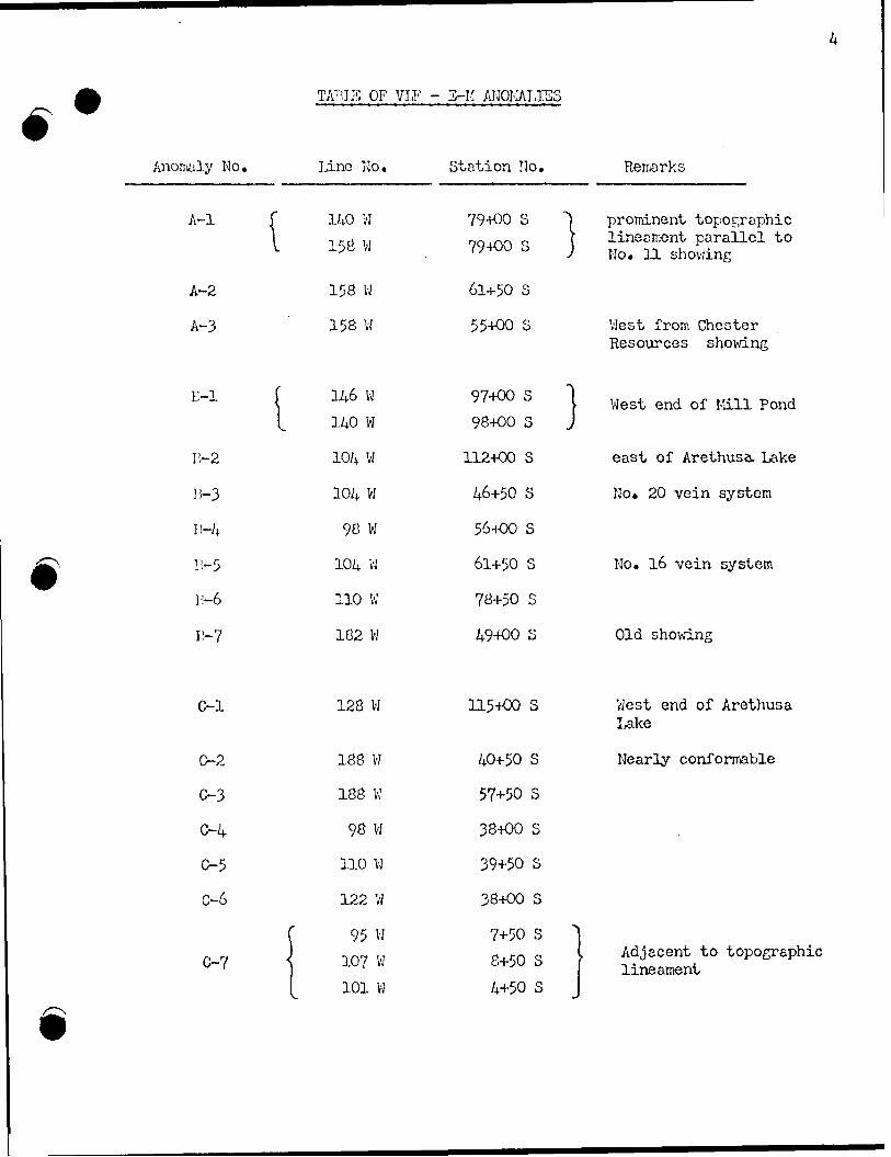
TAlilE OF VIF - 3-K ANOMALIES
Anomaly No.
" lA-2
A-3
E-l f
B-2
B-3
I!-4
r-5
15-6
n-7
O-l
C-2
C-3
0-4
0-5
0-6
C-7
Lino No. Station No.
140 W 79+00 S 1
158 W 79+00 S j
158 W 61+50 S
158 W 55+00 S
146 W 97+00 S 1
140 W 98+00 S J
104 W 112+00 S
104 w 46+50 s
98 W 56+00 S
104 w 61+50 s
110 W 78+50 S
182 W 49+00 S
128 W 115+00 S
188 W 40+50 S
188 W 57+50 S
98 W 38+00 S
110 W 39+50 S
122 W 38+00 S
f 95 W 7+50 S
l 107 W 8+50 S
101 W 4+50 S
Remarks
prominent topographic lineament paranel to No. 11 showing
West from Chester Resources showing
West end of Mill Pond
east of Arethusa. Lake
No. 20 vein system
No. 16 vein system
Old showing
West end of Arethusa Lake
Nearly conformable
Adjacent to topograp lineament
Discussion of Results
The VLF - S-M map shows that the contoured zones generally coincide
with the major cross overs. Contoured values have the advantage that they
indicate the trend of anomalies through areas where the crossovers are not
clearly defined. Some of these coincide with known vein systems such as
No. 16 and No. 20. Others are associated with fault zones such as the north
easterly trending one near No. 2 shaft (Strathmore). A few coincide with
swampy areas and may be the result of better conductivity of wet ground or
due to the presence of a conductor beneath the swamp, or to both. Examples
of this are seen at the west end of Mill Pond and of Arethusa Lake.
The principal anomalous zones are labelled and described in the
following paragraphs in order of priority for investigation.
A ~ Anomalies - first priority
Three anomalies are given top priority rating because they lie on the
westward extension of known mineralized zones and are associated with linear
features showing prominently on the aerial photographs.
Anomaly A-l extends from Weeduck Lake eastward through Deer Lick Pond
to line 98W. It is parallel to and slightly north of a zone of geochemical
anomalies which ivas trenched and mapped as the No. 11 showing. This showing
contains disseminated chalcopyrite associated with diorite and alaskite in
a number of separate localities trending about 100 . The anomaly probably
reflects a fracture or shear zone which may be mineralized. This conductor
widens and strengthens to the westward and should be explored in detail using
soil geochemistry and trenching. The areas of especial interest are located
about 79+00 S on lines 140W and 158W. Two anomalies lying north of A-l ex
tend westward from the boundary with Chester Resources property. These inter
sect line 158 at 61+50 S and 55+OO S and are designated A-2 and A-3 respectively,
The A-3 anomaly probably is the westward continuation of the central showing
on the Chester property and both warrant further exploration.
D - Anomalies - second priority
These include anomalies which occur in the vicinity of known gold
bearing veins such as the No. 20 and 16 vein systems.
Anomaly 13-1 occurs at the west end of Mill Pond near line 14.6W
(97+00 s) and 15-2 lies to the east of Arethusa Lake on line 104W (112+00 S).
These are situated approximately along strike from the No* 3 vein system and
consequently merit detailed examination.
Anomalies B-3 to E-6 lie east of and adjacent to the Chester Resources
property and include the No. 16 and 20 vein systems. Since two of these
anomalies are associated with known gold-bearing veins and all four show
similar trends, they should be explored in detail*
C - Anomalies - third priority
The anomalies in this category are given a lower priority because they
do not have an obvious association with veins or topographic lineaments. How
ever, they represent zones for more detailed exploration because there is no
obvious explanation for them.
D - Anomalies - fourth priority
The anomalies in this category are all associated with known lakes and
swampy areas. Some of these, such as the one trending northeasterly between
Arethusa and Kesomikenda Lakes, probably reflect a local fracture zone which
occupies this depression. This group is given lowest priority because the
anomalies may bc explained by wet ground. However, they should be checked
for the presence of mineralization because Archean mineral deposits often
occur under swamps.
Other low level anomalies occur along strike from known vein systems
such as eastward from No. l vein. These have not teen given a rating because
it is assumed that they will be checked with more detailed work as a result
of continued exploration of the zone.
During the field work insufficient attention was paid to horizontal
control in determining the location of flagged lines and of stations along
these lines. Consequently the precise location of each of the anomalous
regions to be explored in detail should be verified. This may be accomplished
by running one or more short VLF profiles between the older survey lines.
Interpretation of these data assumes that the anomalies are close to
the location plotted. Any significant relocation of survey lines or stations
will invalidate this assumption.
Interpretation of Results
The most prominent topographic lineaments observed on air photographs
of the property are shown on the accompanying map. Two dominant trends are
exhibited by these features: 45 and 90 c to 110 . The first one occurs most
abundantly near Lake Kesomikenda. Probably it is a reflection of fracture
zones developed during a period of right-handed displacement along a NNW
trending fault under the lake. Only one vein (No. 15) which parallels this
trend has been discovered to date.
The second direction is parallel to one set of diabase dykes and to
most of the gold-bearing zones on the Chester and Kurgold properties. It is
interpreted to represent a dominant system of fractures which probably
developed during an earlier period of deformation. Consequently, this trend
has the greatest potential for hosting gold-bearing quartz veins. In the
northern part of Chester townships these linear features may simply reflect
the trend of formations. However, they should be investigated in detail
because of their potential for hosting strata bound mineralization.
Most of the VII1' - E-M anomalies show trends that coincide with one or
the other of these sets of lineaments. Consequently, the anomalous zones are, ,s~/
interpreted to be reflections of these linear features. f /-///1/
7i/li *

REFERENCES
Fraser, D. C. (1969) "Contouring of VLF - S-M Data" Geophysics Vol. 34i No. 6 pp 958 - 96?
4 l P l2SW007I 2.4888 CHESTER900
Our File: 2.4888
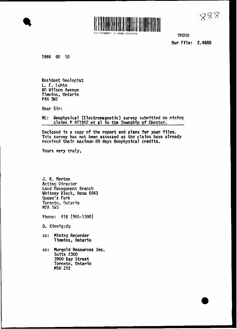
1984 02 10
Resident Geologist L. T. Luhta 60 Wilson Avenue Timmins, Ontario P4N 3W2
Dear Sir:
Rt: Geophysical (Electromagnetic) survey submitted on mining claims P 471952 et al 1n the Township of Chester.-mm .
Enclosed 1s a copy of the report and plans for your files. This survey has not been assessed as the claims have already received their maximum 80 days Geophysical credits.
Yours very truly,
J. R. MortonActing DirectorLand Management BranchWhitney Block, Room 6643Queen's ParkToronto, OntarioM7A 1W3
Phone: 416 (965-1380)
D. K1nv1g:dg
cc: Mining Recorder Timmins, Ontario
cc: Kurgold Resources Inc. Suite 2300 3900 Bay Street Toronto, Ontario M5H 2Y2
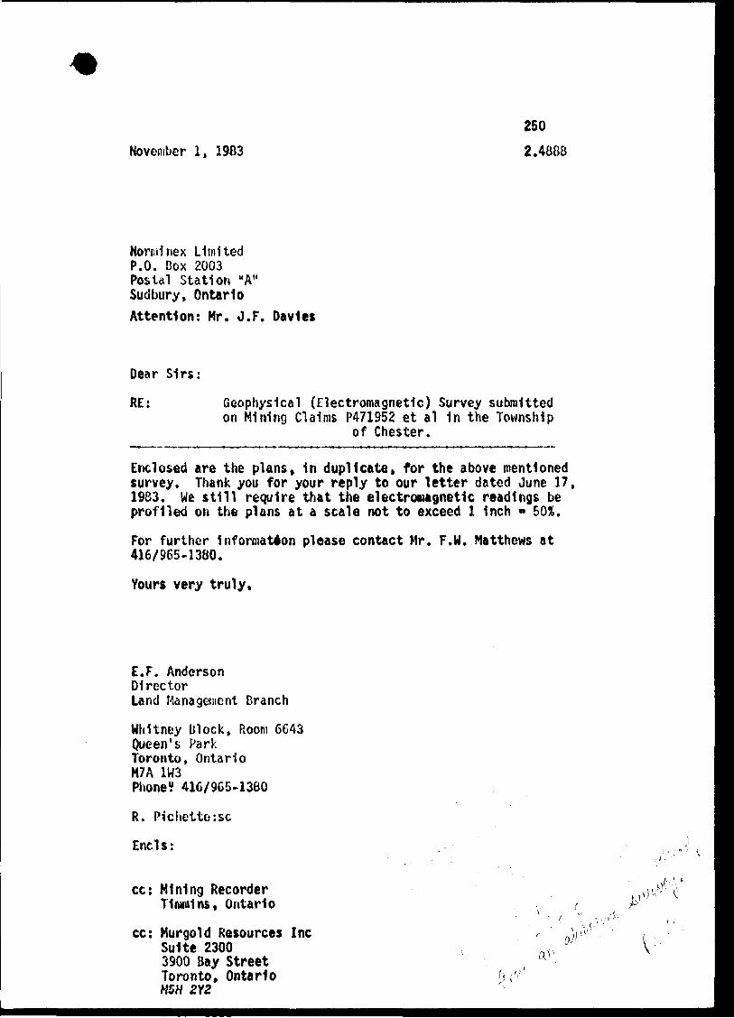
November l, 1983
250
2.48G8
Nornilnex Limited P.O. Box 2003 Postal Station "A" Sudbury, OntarioAttention: Mr. J.F. Davies
Dear Sirs:
RE: Geophysical (Electromagnetic) Survey submittedon Mining Claims P471952 et al 1n the Township
of Chester.
Enclosed are the plans. In duplicate, for the above mentioned survey. Thank you for your reply to our letter dated June 17, 1983. We still require that the electromagnetic readings be profiled on the plans at a scale not to exceed l Inch - BOX.
For further Information please contact Mr. F.W. Matthews at 416/965-1380.
Yours very truly,
E.F. AndersonDirectorLand Management Branch
Whitney Block, Room 6643Queen's ParkToronto, OntarioM7A 1W3Phone? 416/965-1380
R. P1chetto:sc
Ends:
cc: Mining Recorder Tlnwlns, Ontario
cc: Murgold Resources Ine Suite 2300 3900 Bay Street Toronto, Ontario HSH 2Y2
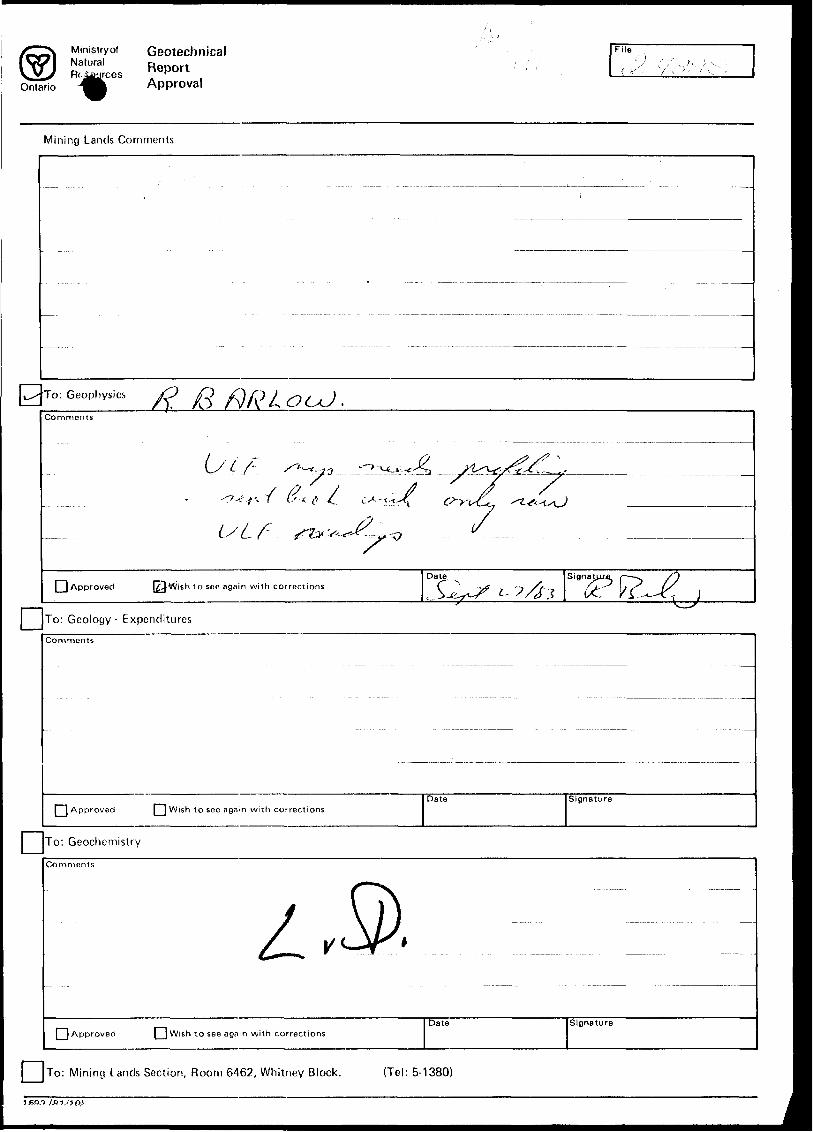
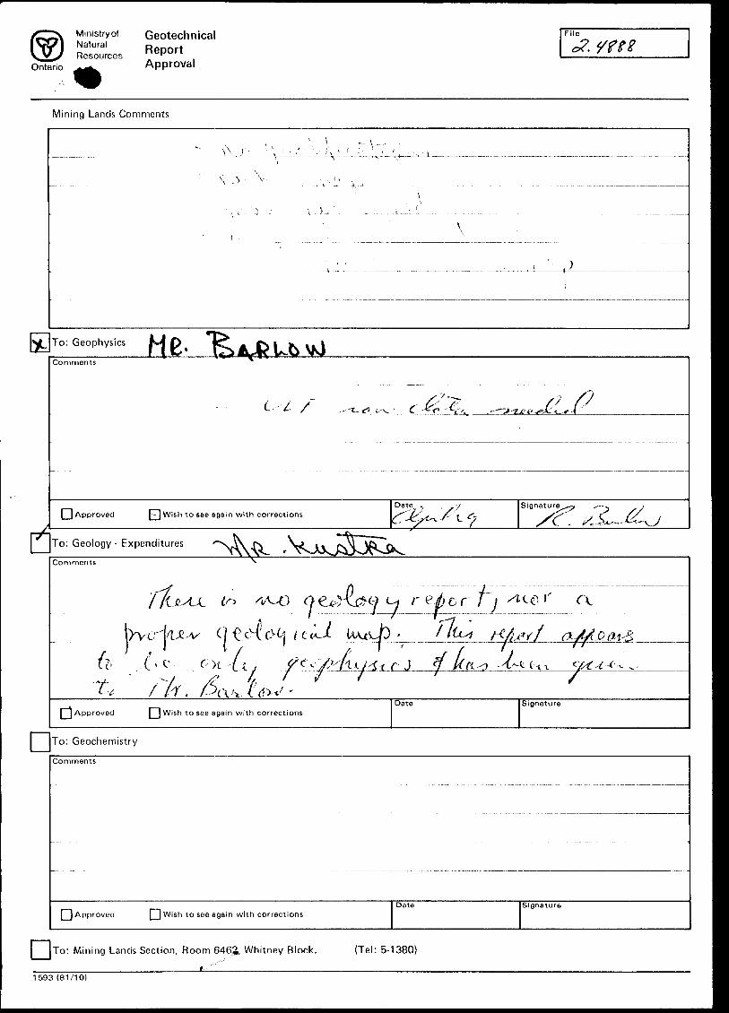
Ministry ofNaturalResources
Ontario
GeotechnicalReportApproval
File
Mining Lands Comments
To: Geophysics ft fe f) ft
Comments
i;L f
Approved [24Wish to sec again with correctionsDate Sign
To: Geology- Expenditures
Comments
] Approved [ ] Wish to sec agam with correctionsDate Signature
To: Geochemistry
Comments
Approved Q Wish to see again with correctionsDate Signature
j [TO: Mining Lands Section, Room 6462, Whitney Block. (Tel: 5-1380)
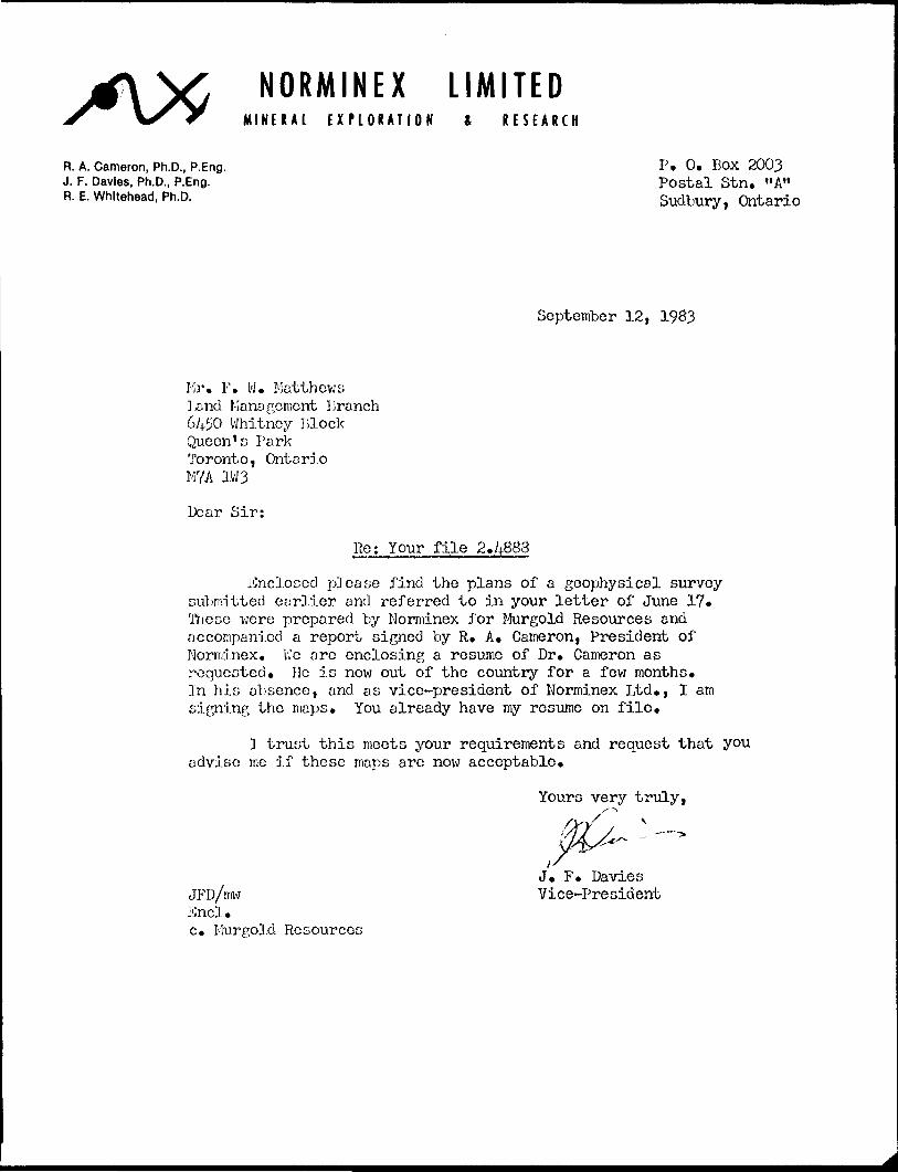
NORMINEX LIMITEDMINERAL EXPLORATION ft RESEARCH
R. A. Cameron, Ph.D., P.Eng. P. 0. BOX 2003J. F. Davies, Ph.D., P.Eng. Postal Stn. "A"R. E. Whitehead, Ph.D. Sudbury, Ontario
September 12, 1983
Mr. F. W. Matthews land Management Branch 6450 Whitney Block Queen's Park Toronto, Onto rio M7A 1W3
Dear Sir:
Re: Your file 2.4888
Enclosed please find the plans of a geophysical survey submitted earlier and referred to in your letter of June 17. These were prepared by Norminex for Murgold Resources and accompanied a report signed by R. A. Cameron, President of Norminex. VJe are enclosing a resume of Dr. Cameron as requested. He is now out of the country for a few months. In his absence, and as vice-president of Norminex Ltd., I am signi.ng the maps. You already have my resume on file.
l trust this meets your requirements and request that you advise me if these maps are now acceptable.
Yours very truly,
J. F. DaviesJFD/niw Vice-President End. c. Murgold Resources
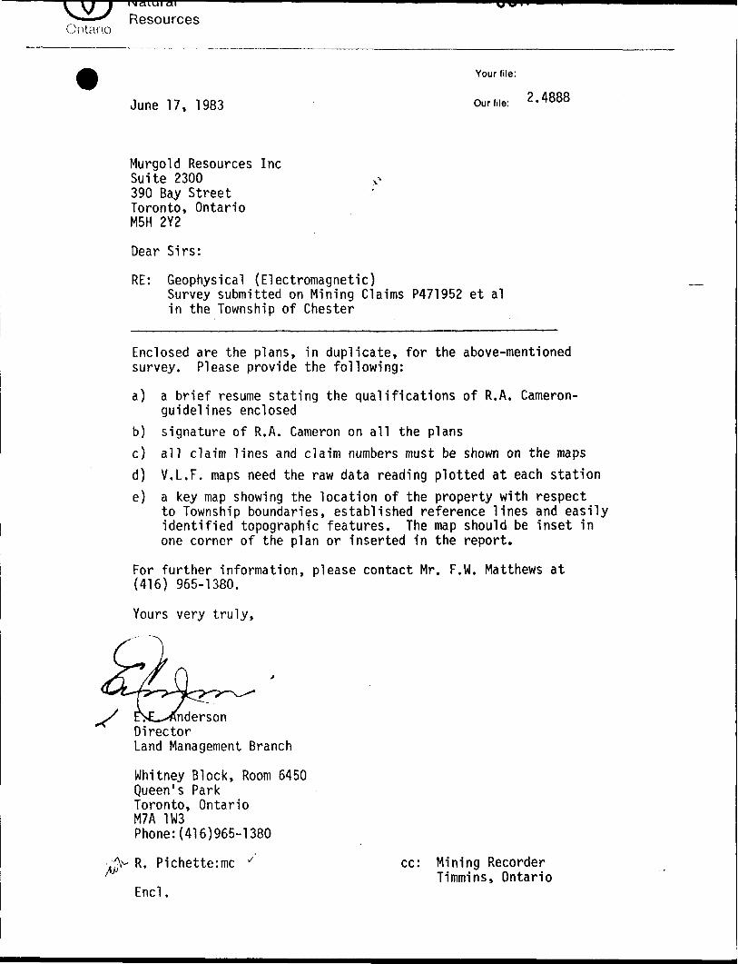
Resources
Your file:
2.4888June 17, 1983 our file.
Murgold Resources IncSuite 2300 o390 Bay StreetToronto, OntarioM5H 2Y2
Dear Sirs:
RE: Geophysical (Electromagnetic)Survey submitted on Mining Claims P471952 et al in the Township of Chester
Enclosed are the plans, in duplicate, for the above-mentioned survey. Please provide the following:
a) a brief resume stating the qualifications of R.A. Cameron- guidelines enclosed
b) signature of R.A. Cameron on all the plans
c) all claim lines and claim numbers must be shown on the mapsd) V.L.F. maps need the raw data reading plotted at each statione) a key map showing the location of the property with respect
to Township boundaries, established reference lines and easily identified topographic features. The map should be inset in one corner of the plan or inserted in the report.
For further information, please contact Mr. F.W. Matthews at (416) 965-1380.
Yours very truly,
nderson Director Land Management Branch
Whitney Block, Room 6450 Queen's Park Toronto, Ontario M7A 1W3 Phone:(416)965-1380
R. Pichette:mc ^ cc: Mining RecorderTimmins, Ontario
Encl.
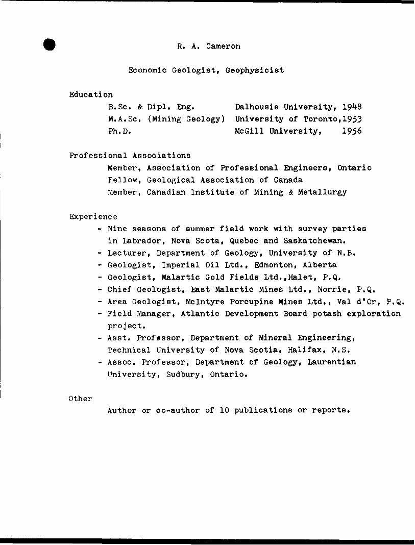
R. A. Cameron
Economic Geologist, Geophysicist
EducationB.Se. Se, Dipl. Eng. Dalhousie University , 1948 M.A.Se. (Mining Geology) University of Toronto,1953 Ph.D. McGill University, 1956
Professional AssociationsMember, Association of Professional Engineers, OntarioFellow, Geological Association of CanadaMember, Canadian Institute of Mining & Metallurgy
Experience- Nine seasons of summer field work with survey parties
in Labrador, Nova Scota, Quebec and Saskatchewan.- Lecturer, Department of Geology, University of N.B.- Geologist, Imperial Oil Ltd., Edmonton, Alberta- Geologist, Malartic Gold Fields Ltd.,Halet, P.Q.- Chief Geologist, East Malartic Mines Ltd., Norrie, P.Q.- Area Geologist, Mcintyre Porcupine Mines Ltd., Val d'Or, P.Q.- Field Manager, Atlantic Development Board potash exploration
project.- Asst. Professor, Department of Mineral Engineering,
Technical University of Nova Scotia, Halifax, N.S.- Assoc. Professor, Department of Geology, Laurentian University, Sudbury, Ontario.
OtherAuthor or co-author of 10 publications or reports.
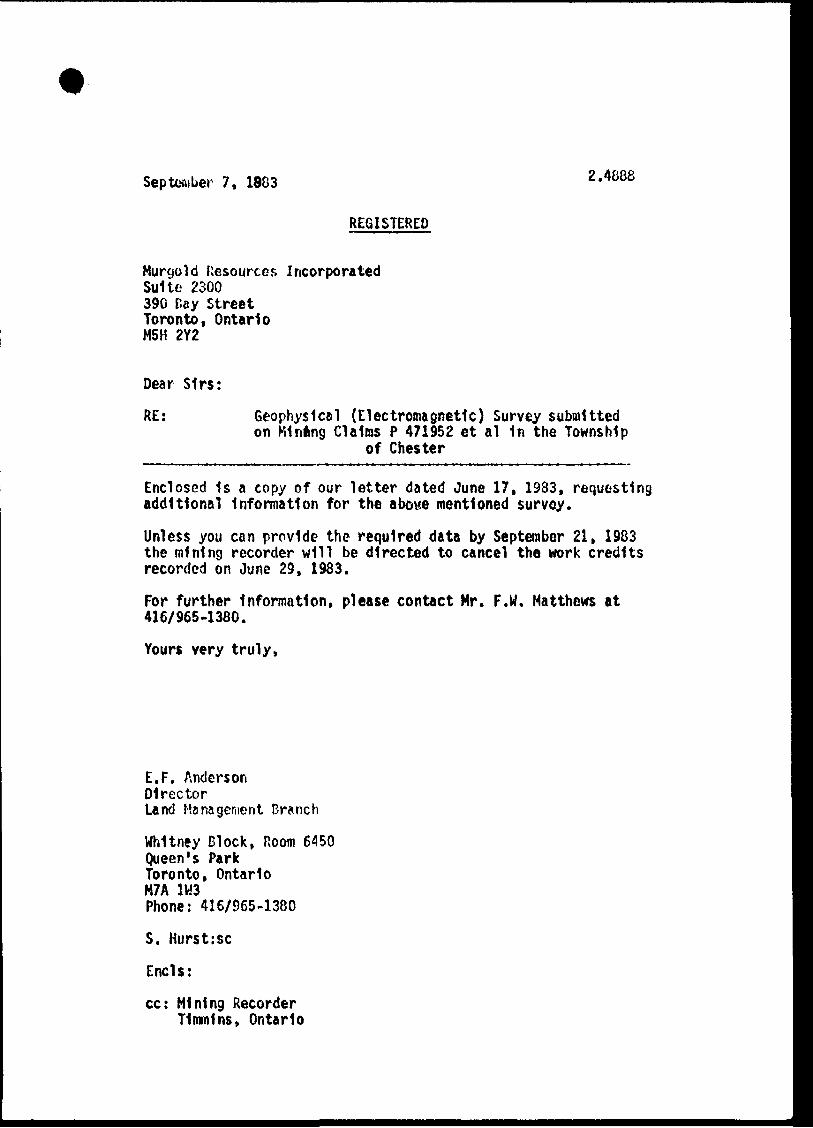
September 7, 1883 2.4888
REGISTERED
Murgold Resources Incorporated Suite 2300 390 T.ay Street Toronto, Ontario M5H 2Y2
Dear Sirs:
RE: Geophysical (Electromagnetic) Survey submitted on Minting Claims P 471952 et al 1n the Township
of Chester
Enclosed 1s a copy of our letter dated June 17, 1983, requesting additional Information for the above mentioned survey.
Unless you can provide the required data by September 21, 1983 the mining recorder will be directed to cancel the work credits recorded on June 29, 1983.
For further Information, please contact Mr. F.W. Matthews at 416/965-1380.
Yours very truly,
E.F. AndersonDirectorLand Management Branch
Whitney Block, Room 6450Queen's ParkToronto, OntarioM7A 1W3Phone: 416/965-1380
S. Hurst:sc
Ends;
cc: Mining Recorder Timmins, Ontario
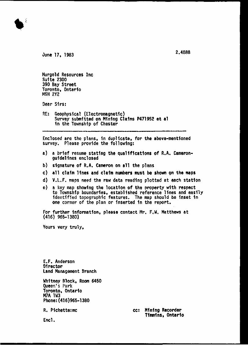
June 17, 1983 2.4888
Murgold Resources Inc Suite 2300 390 Bay Street Toronto, Ontario M5H 2Y2
Dear Sirs:
RE: Geophysical (Electromagnetic)Survey submitted on Mining Claims P471952 et al 1n the Township of Chester
Enclosed are the plans, 1n duplicate, for the above-mentioned survey. Please provide the following:
a) a brief resume stating the qualifications of R.A. Cameron- guldellnes enclosed
b) signature of R.A. Cameron on all the plansc) all claim lines and claim numbers must be shown on the mapsd) V.L.F. maps need the raw data reading plotted at each statione) a key map showing the location of the property with respect
to Township boundaries, established reference lines and easily Identified topographic features. The map should be Inset 1n one corner of the plan or Inserted 1n the report.
For further Information, please contact Mr. F,W. Matthews at (416) 965-1380)
Yours very truly,
E.F. AndersonDirectorLand Management Branch
Whitney Block, Room 6450 Queen's Park Toronto, Ontario M7A 1W3 Phone:(416)965-1380
R. P1chette:mc
Encl.
cc: Mining Recorder Timmins, Ontario
Ontario
Ministryof Geotechnical
ReSces R eportApproval
. y f r?
Mining Lands Comments
To: Geophysics
Comments
L.'-L
Approved P-j Wish to see again with correctionsSignature
To: Geology-Expenditures
Comments
t" i r g
( e o,'/, .(-t
\\ A pproved [ j Wish to see again with correctionsSJQnature
To: G eochemistry
Comments
Q Approved Q Wish to see again with correctionsDate Signature
l—\JTo: Mining Lands Section, Room 646^, Whitney Block. (Tel: 5-1380)
1593 (81/10)

1982 07 05 2.4888
Mining RecorderMinistry of Natural Resources199 Larch StreetSudbury, OntarioP3E 5P9
Dear sir:
We have received reports and maps for a Geophysical (Electromagnetic) survey submitted under Special Provisions (credit for Performance and Coverage) on mining claims 8 471952 at al in the Township of Chester.
Vis material will be examined and assessed and a statement of assessment work credits will be issued.
Yours very truly,
E.F. AndersonDirectorLand Management Branch
Whitney Block, Room 6450Queen's ParkToronto, OntarioM7A 1W3Phonet 416/965-1316
J. Skura/sc
c.c. Murgold Resources Inc Gogama, Ontario
c.c. Norminex Limited Sudbury, Ontario Attni R.A. Cameron
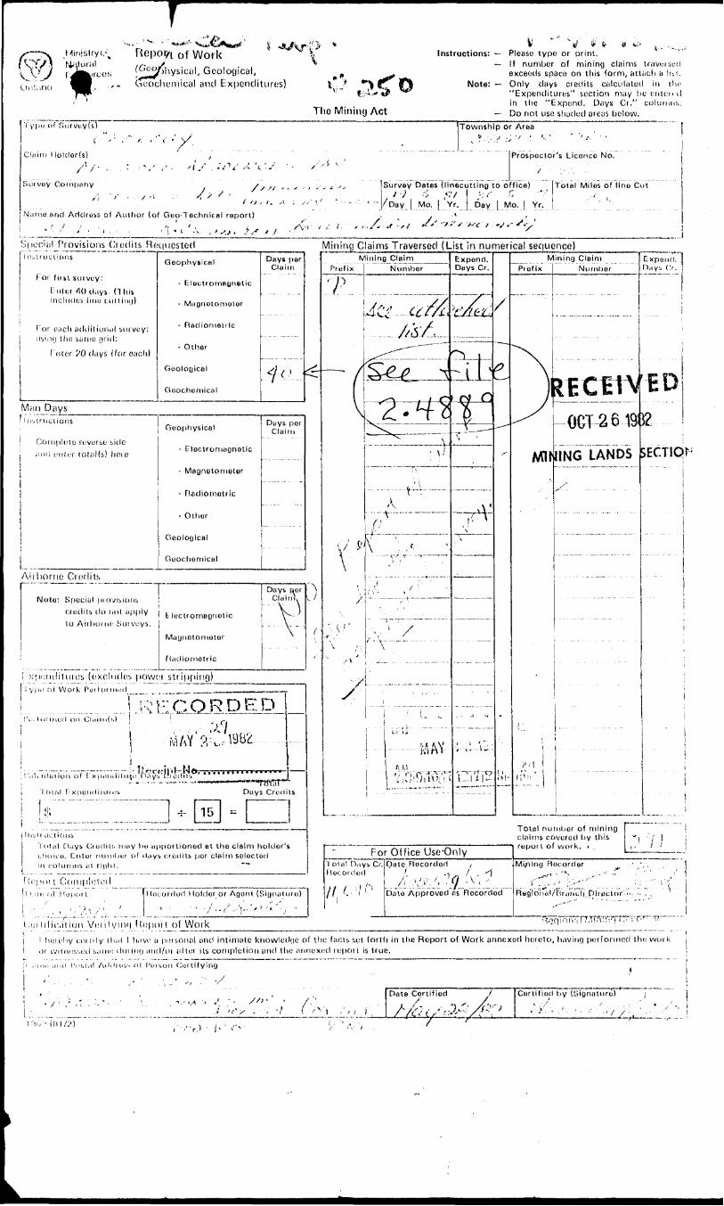
rof Worksical, Geological, ical and Expenditures)
The Mining Act
., ......Instructions: — Please type or print.
— If number of mining claims triiveised exceeds space on this form, attach a liit.
Note: — Only days credits calculated in the "Expenditures" suction may lie onion il in the "Expend. Days Ci." columns.
— Do not use shaded areas below.Typu (if fuirvtiy(s)
4 v,-, ,-c-y;Claim Hoklor(s) ,
y* /- * i ^ r ' ,' ' "i s' *'*''1 i"' •'"i- ''Survey Company y
/l V - .V" /' '' ,,,
]N;ime and Adclru&s of Author (of Goo-Technical report)
Township or Area
Prospector's Licence No.
Survey Dates (llnecuttlng to office)/•; --; *-,y -;.-- r,/Day l Mo. [ Yr, Day [ Mo. | Yr.
Total Miles of lino Cut
•' ' ' ' ' ' * . - - ''l- 1 '.v , '^ .Special Provisions Credits Requested
n:.iructicins
F or f it si sui vuy :t-nler lOil.iys, (This includes iiuu cnl l iny)
F or each atklitional survey; uviHj Ihii same (irid:
t : nler ?0 days (for each)
*s .1 1 • ^•" ' '' ' ' '"'' •' ~ ' ! ~ ' '^ s j
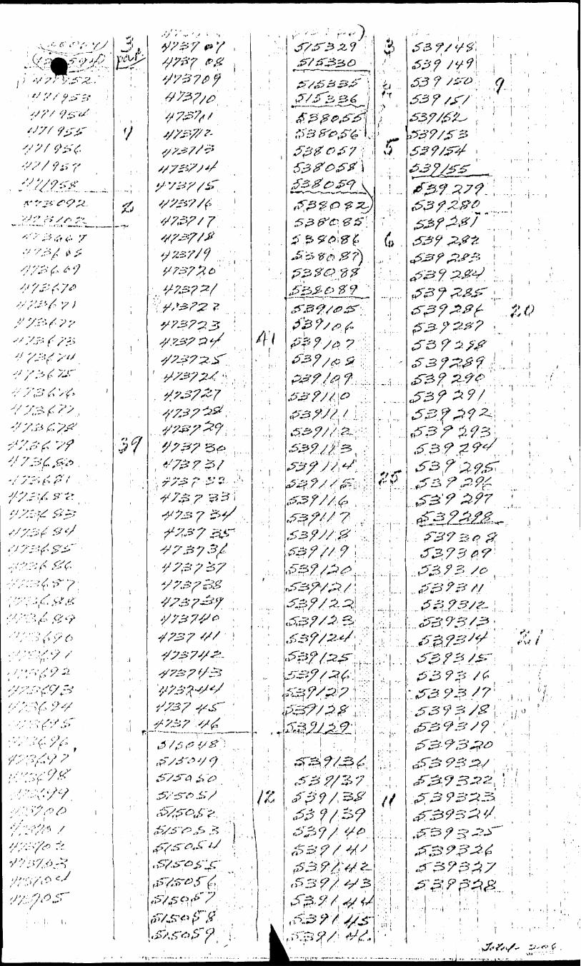
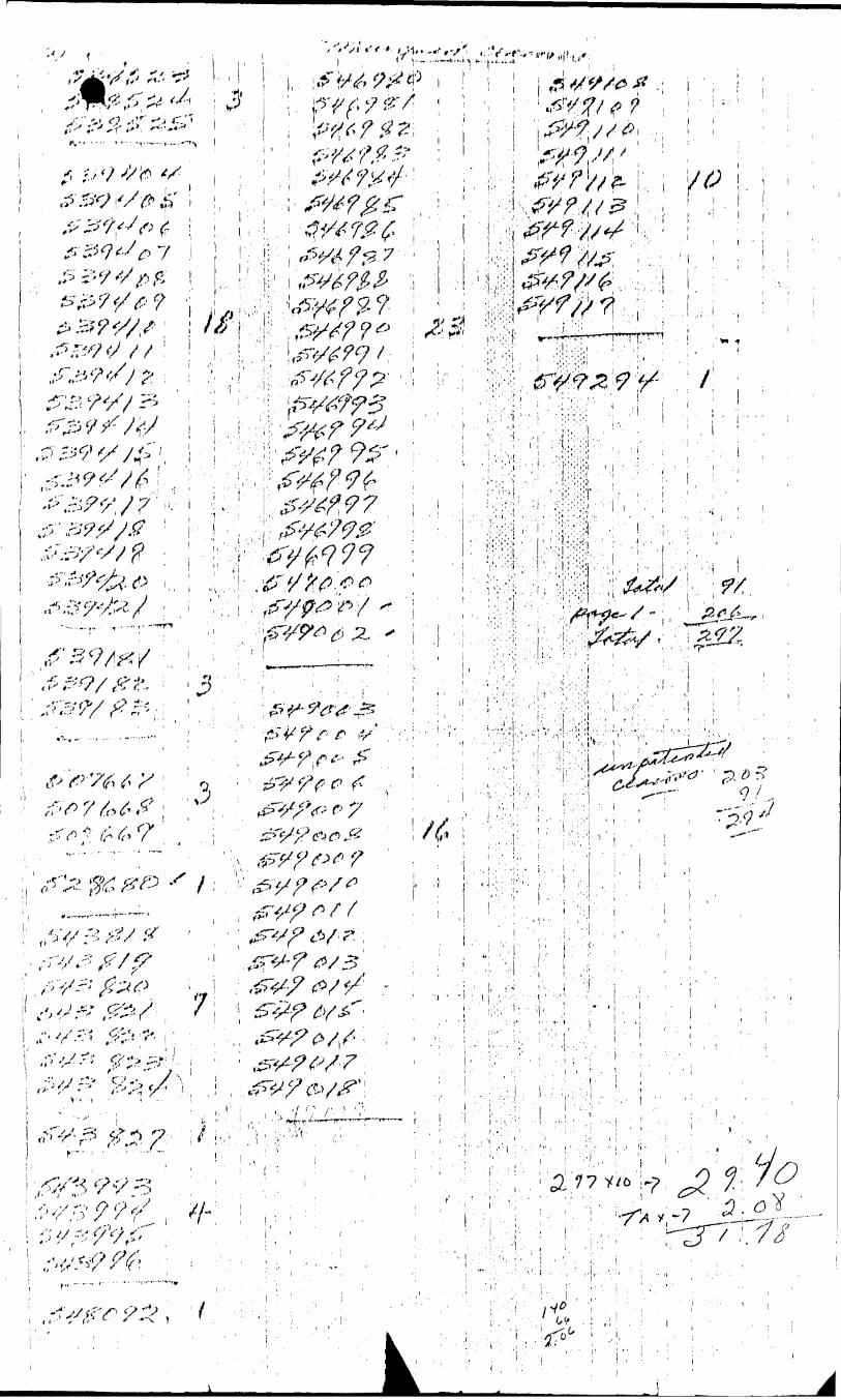
Mining Claims Traversed (List in numerical sequence)Geophysical
- EloutroniBonetlc
- Mugnotometor
- Radiometric
- Other
Geological
Geochemical
Man Days
Days per Claim
.4'-.-
' irr.lruclions 1 ' Geophysical
r- i ^ t l
and milter (otalls) heie
i . ....
- Eloctromaflnot
- Magnetometer
- ruidiometrlc
- Other
Geological
GoochernicEil
Aii home Credits
Noto: Special pi ovibioiib credits di) mil apply lo Aiiboi n(t S ut vuy s.
f
tloctrornagnetic
Magnetometer
Radiomotric
c
Duys por Claim
Days Clai
\Re r
3
V
I xjiiMKihures (excludes powei stripping)i ypa of Work Pel toning ^^
' K' •r c Q R D iED!'i i Uirmufl on Claiiiid.l ' ^ f
ii ' ii \trr'xZx.!i!rT-- ?*i i tj-
. (liedils " | ___ t
r
1 - f 15 ! -1 l -J
•—i)ay
tra'r
--
Credits
j 1 ll^i ( LlClifJJli
'l oiiil Diiys t^itjdiij. nuiy bu ci|)[)ortionod at the claim holder's t; ho i co, Tntor iiiniibur of tUiys cr od its por clai rn selected
j in roki runs i\\ r hjht. ""
tt.'P 0 ' t CompletedJ 1 i.; in i \\ 1 'upu( t 1 lUu.ordod Holder or Agon t S rjruilure
- '' , , .-.V.i/",' ' 1 ' " -/•./-• :!-''-"''v 'l -iji hluviiiun Vi.'iil yi ni lio pot l of Work
st-
3f
rvPrufix
J
\ :- .
f \ '
S
inlng ClaimNumber
Ar*-*-V
^^ J^
T'^
V jj/L-
^L^-^
z^n^..' \'
A\-— — — --- -
...}j. f'..^. _ ;^•;: ' -
^:::"
L.I' i jr, t (i y
*, Kl
l,...",.1 .:.-...........:.
Expend. Days Cr.
^
5t
t
\ *
\!
——————
' .^ ^ _ J ^
'i"!rl|S
/
-~-~ — -
P
i*'
Mining ClaimPrefix
^N
^)
MU
i '
Total claims
For Office Use-Only"1 01 al D,iy Roeordoc
H^\
sCr.
"i
pate Recorded ,
Dale Approved as Recorded
Mi/i in(.••••*™
HOBIOI
Number
V C \at C 1 *
-OGW8-8
UNO LANDS
s: .... .. . .. .
. ....... .... ^^ .
riurnbor of mining 1 covered by this ^ of work. * , 1^^.
Recorder y ' (rr-r- - '*:- ^ J M ," -' -' -
al/hranch.pljflplnr....^
Bxpenfl.Diiyi Ci. j
c rvfcP
SECTIQ
i
i
i
•'t 'i i
:.' ':'\. .
.Wiion-dMi.rri'M.. M- ..
iy 1:111 lily ili.u l h.ivn a piirsonal und intimate knowledge of the facts sot forth in the Report of Work annexed herelo, having performed the work uiSM.'d sami; ilmiii'.i mid/Di alti!i its completion and the annexed rupoil is true.
J'risl.H Ailtliii-j-. ol I'oison (;uitifytno
Date Cqrtifiod 7 Certified t y (U.onaturo)
( - l "' l
' -; ' l ' : , , ..,,,' l , i . . (
i ,. l , ,: ;.. J....f. ,i r:
if r '
l ' j.l
. .j....
?.r(j
-.; ...i ji. i y i 'y .t*'* y /-e"*" •••; i '/c -^6^-^
•i
(5X20)2^ \,———
i-C
t
l .1
.''
o 6? t;:.-; t.-J, ̂ OT1.;-. /V- 1- - S-S / t.,--, f t
;" -
7ft'H
:
f ̂
^^V
'^^H
C-'l v. hivx-s
V
V \
: ^^^^fc
^^^-^
w^cN
^^l^
^^^^ ^ ^
K^
X
X
^^
\t^
^
^^
^^
^
^^
-^
^
^ ̂
\VX
^
C
.
X
\
^^-
vi. .\\ m K
VN ^ V>
^
^i
|.V V
V.\V
L' l
^^
Ontario
Ministry of Natural Resources
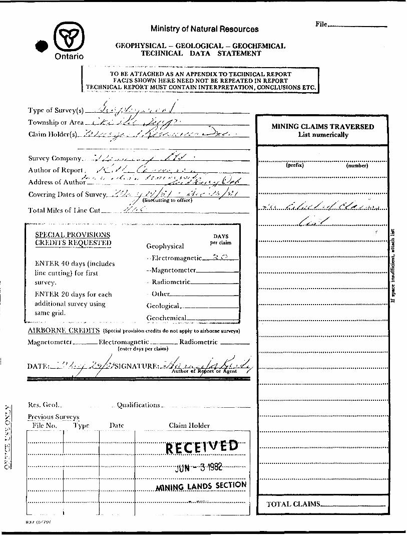
GEOPHYSICAL - GEOLOGICAL - GEOCHEMICAL TECHNICAL DATA STATEMENT
File.
TO BE ATTACHED AS AN APPENDIX TO TECHNICAL REPORTFACTS SHOWN HERE NEED NOT BE REPEATED IN REPORT
TECHNICAL REPORT MUST CONTAIN INTERPRETATION, CONCLUSIONS ETC.
Type of Survey(s) —
Township or Area —
Claim Holder(s)^J2l
'-/c ' : /. '/.' ' / .-- y * ' f J.
J
Survey Company^ _ ,Sj^s ,.,.
Author of Report ,-A . S '/^ .'. 11 , st
Address of Author _______
Sf
JL.
s
'f.rf e -'-- C f
Covering Dates of Survey_,^s- :/ /,'/ (linetutting to office)x'/
Total Miles of Line Cut._
,-/^ -/t, A;s
SPECIAL PROVISIONS CREDITS RKQUESTEI)
ENTER 40 days (includes line cutting) for first survey.
ENTER 20 days for each additional survey using same grid.
,, , . , Cieophysicai
DAYS per claim
- Magnetometer
-Radiometric —
Other ̂ ———
Geological.
GeochcmicaL
AIR B O R N KG R E l) IT S (Special provision credits do not apply to airborne surveys)
Magnetometer ̂ .Electromagnetic.. _ Radiometric(enter days per claim)
DATE: -.Author *f Report or Agent
Res. Gcol..
Previous Surveys File No. Type
^ Qualifications^
Date Claim Holder
MINING CLAIMS TRAVERSED List numerically
(prefix) (number)
l
11
TOTAL CLAIMS-

GEOPHYSICAL TECHNICAL DATA
nioie than one survey, specify data for each type of survey
Number of Stations
Station interval
Profile scale
Number of Readings
Line spacing -——^—
Contour interval ^
*-~( H Wyto
Instrument
Accuracy — Scale constant —.
Diurnal correction method ^
Base Station check-in interval (hours).
Base Station location and value _^__
o*~i
H Wy, o
o rtu w.J w
InstrumentCoil configuration
Coil separation
Accuracy
Method:
Frequen cy ____ .
/V
Parameters measured
Fixed transmitter D Shoot back CD In line CI] Parallel line
{specify V.L.F. station)
c?o
Instrument
Scale constant
Corrections made.
Base station value and location .
Elevation accuracy.
yi hf.,i t-J
oi f;li r!Q [o!
to c/:U| c''
Instrument ..—^———-———
Method D Time Domain
Parameters - On time ^^——
- Off time ^——.
Delay time ^^
Integration time.
Electrode array —
Electrode spacing .
Type of electrode
l l Frequency Domain
— Frequency ————
— Range ________
SK],l rOJKNJJA),Instrument.___________________________________________ Range.Survey Method.——-—--——————————————-.—-.————-——...——--—.-.————
Corrections made.
KAniOMl.TKIC Instrument ———
Values measured .Energy windows (levels) ^.-——.—-^-^.-^--—.^-————————————————^——^
Height of instrument______________________________Background Count. Size of detector—-———^^—^—^—^—.—^—^-^^^^^^^^^^.^^.^^^.^^..^^.^..^^.^
Overburden .———.^-^—.^—-—^——.^^—--———----——.—-.——-—----——--——————-—..^———-——(type, depth — include outcrop map)
OTiiKRs {si.JSMJO, jmii.LWJ.j.i, LODGING KTC.)Type of survey—^-^—^^-.^^—^^—————-———
Instrument __________ _________________Accuracy—-——^—————-——.———————————Parameters measured ^—^—.————^—.—^—..—^.
Additional information (for understanding results).
AIKHOKNJ, SURV)-VSType of survcy(s)_______________—————————————————
Instrumcnt(s) ——————————————————————————————————(specify for each type of survey)
Accuracy___________.—,—^——(specify for each type of survey)
Aircraft used ~~.—.—————-—^-^...-^-^———^—^—————————.
Sensor altitude^—.Navigation and flight path recovery method.
Aircraft altitude__________________________________Line Sparing Miles flown over total area___________________________Over claims only.
•f
'r
V-
N \

GEOCHEMICAL SURVEY - PROCEDURE RECORD
Numbers of claims from which samples taken.
Total Number of Samples-
Type of Sample.(Nature of Material)
Average Sample Weight—-——-———
Method of Collection ^-——————.
Soil Horizon Sampled-
Horizon Development.
Sample Depth-————
Terrain———————
Drainage Development____________
Estimated Range of Overburden Thickness.
SAM I'M, 1'RKl'A RATION{Includes drying, screening, crushing, ashing)
Mesh size of fraction used for analysis.————
Values expressed in: per cent p. p. m. p. p. b.
D dn
Cu, Pb,
Others-—
Zn, Ni, Co, Ag, Mo, As.-(circle)
Field Analysis
Extraction Method.
Analytical Method-
Reagents Used-——
Field Laboratory Analysis
No. ___________
Extraction Method.
Analytical Method .
Reagents Used ^——
Commercial Laboratory (-
Name of Laboratory_
Extraction Method-—
Analytical Method——-
Reagents Used ^———-
.tests)
.tests)
-tests)
Gene ral-^———— General.
' 1 l
NORMINEX LIMITED ! - '
P.O. BOX2003 R ECEIVEDTerminal "A"
Sudbury Ontario , J UN ~ 31982
MINING LANDS SECTIOfc
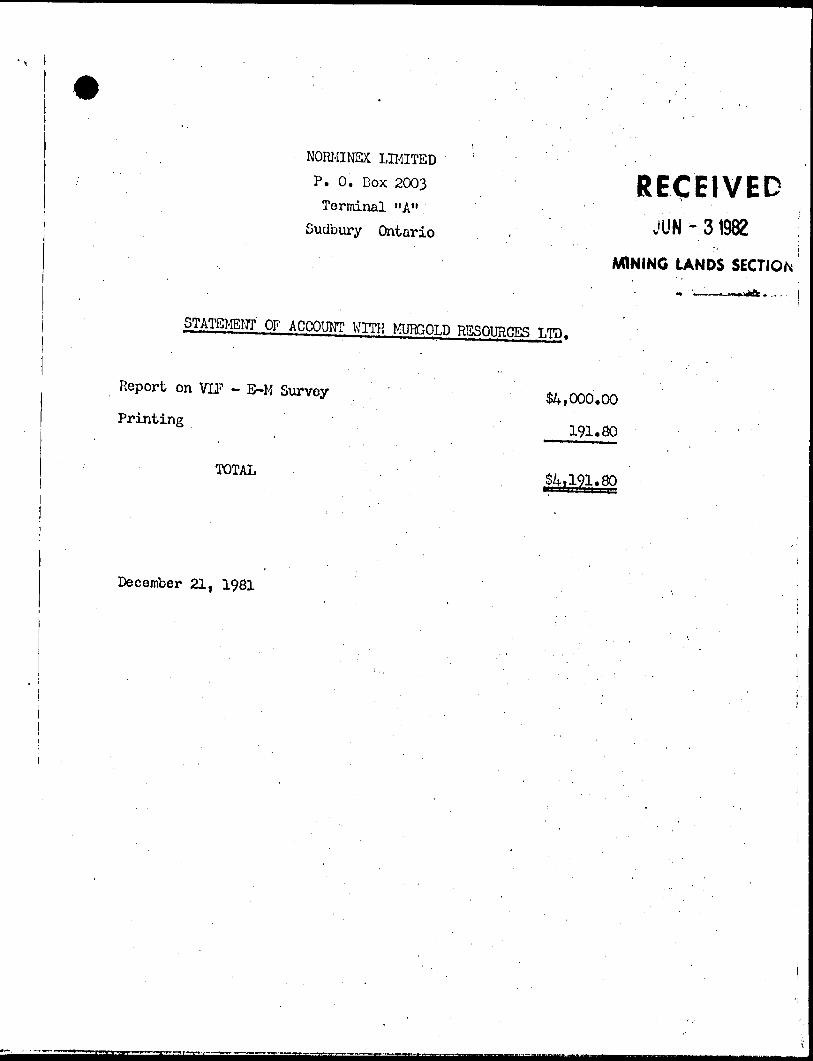
STATEMENT OF ACCOUNT WITH MURGOLD RESOURCES LTD.
Report on VLF - E-M Survey S4,000.00
Printing 191*80
TOTAL
December 21, 1981
i ' -
x
\ \S
- 3 ^. •- -x
.
r
^^ ̂
^\
^ ̂ A?
^ J
J
l ^ ^
^^ *
\ \r\
^*
^ ^
f^v^
r J
1^;
^
.nn i
'^H
] -
M t.
O-
\
"xft
* -
- -
H
UJn!CUiUJI o
GOgo
S a.'
OUJ
NEViLLt TP M 8h^
'. ' ,- .^pu-,^'/ J, - - "i A17 ! ^ ' l '--^^T'. , i f/ i- y * \.) t i '.-' " , t-1 ,' "' -i^ -•••.' v " ' ',, f p).*. i - -;,~; -- - -- — —x-'.^i~,.- J ^ -j,- — r T~--'-' -p -*v^ ~ -r:
- - y-^^-'t^ 'Fft ji/ 1* i aa
V
'473723 , 473724,473713, 4' 3704 t1 546986 546985 ,M6964'-- .....— H- —— --- -T - - p , p
473731 473730 473729(4737261 473705
549294' 3491 1 7 '549006 l 549003 34900*484 (9003 473745J-^--- J -- . .-. -i. -- - - J - ~- -.
-Sec 42(R.B.O. 60) of
l M
INVERGARRY TP. M.948
ooIOto
Q-H
cnC/)tu5UJ
UJ CD
CHESTERDISTRJCT OF
SUDBURY
PORCUPINE MINING D IVISION
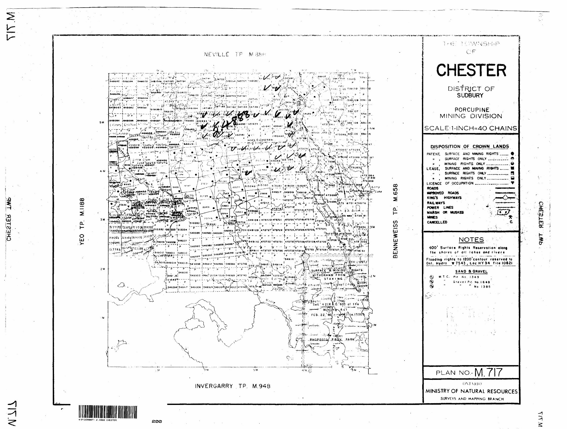
SCALE:1-INCH-4O CHAINS
DIS^pSJTION OF CROWN LANDSPATENT, SURFACE AND MINING RIGHTS'...
H , SURFACE RIGHTS ONLY __;__,.n ( M INfNG R IGHTS ONLY __..__.
LEASE, SURFACE AND MINING RIGHTS ta ,.. , SURFACE RIGHTS ONLY.___.n , MINING RIGHTS ONLY__.™
LICf NCE OF OCCUPATION ____.__r^.,ROADStMPROVEO ROADSKING'S HIGHWAYS
te em
POWER LINES MARSH OR MUSKEG MINES CAMCEUUEO
NOTES ;400 1 Surface Right! Reservation along t h* shores of au laXes ond rivers
Flooding rights to IZOO'contour rttfrvcd to Ont. Hydro V 7543 , Loc HY 34 fitt 1062*
SAND S GRAVEL(Jj) M. T. C, Pit No. l 34 9
® " Grfl ve l Pil No l 649® " " N o l 3 8 5
PLAN NO.-M. TIT
ovr\Kio MINISTRY OF N ATURAL RESOURCES
SURVEYS AND MAPPING BRANCH
a:mwKmo:
cr
41P12SW8071 2 .4888 CHESTER

-V
\
p^ "
* "-
^ f
' l-
\
r~2"-~
—30
07•t-
7To
pogr
aphi
c lin
eam
ents
t—
——
*
#l
"MUR
GO
LD R
ESO
URCE
S IN
C.
VLF
-EM
M
AP
CRO
SS-O
VERS
and
CO
NTO
URS
of F
ILTE
RED
DATA
Prep
ared
by
Nor
min
ex L
td.
V
r\ V
\
41P12SW0071 2.4888 CHESTER
210
L203
W
l IQ
^u/
; - ^
y ^_
*mm
mm
mm
m\*
mm
mm
mm
LEG
END
p-~-—^
f
VLF
-EM
filte
red
in-p
hase
com
pone
nt
(con
tour
inte
rval
-^A
vera
ge p
eak
valu
e fo
r in-
phas
e cr
oss-
over
^
to
Dece
mber
1981
NO
TE;C
OMME
MceM
ewT
POIN
T ro
a AU
. CO-
OHWN
ATBS
N.E
C
OR
NE
R,
CH
E8T
CR
TO
WN
SHIP
1
*0,0
00
*.
40,0
00'N
B.L.
26
S
B.L
.62+
50S
M U
RGO
LD R
ESO
URCE
S^NC
.
MAP
CRO
SS-O
VERS
and
CO
NTO
URS
of F
ILTE
RED
DAT
A
Prep
ared
by
Nor
rWne
xNo
vem
ber
1982
LEG
END
VLF-
EM f
iltere
d irj
-pha
se c
ompo
nent
(c
onto
ur in
terv
al * I
0%)
BE
Ki;,
CL
LAK
EAv
erag
e pe
ak va
lue fo
r In-
phas
e cr
oss-
over
s
200Xo
to
MA
P
NO
41P12SW0071 2.4888 CHESTER
LEGE
NDM
URG
OLD
RES
OUR
CES
INC.
B.L
.I20S
VLF-
EM f
iltere
d in-
phas
e (co
ntou
r int
erva
l -10
%)
Aver
age
peak
value
for i
n-p
VLF
-EM
M
APx
OVE
RS a
nd C
ONT
OUR
S of
FIL
TERE
D DA
TACR
OSS
Prep
ared
by
Nor
mine
x Lt
d.No
vem
ber
1982
I0%
to
20%
20
% to
30%
>3
0%
Topo
grap
hic
linea
men
ts
B.L
.I5Q
S
B.L
I 70
S
B.L
.2IO
S
41P12SW8071 2.4888 CHESTER
B.L.
J5C
XS
RO
UN
LA
KE
S C
AL.
t'O
C
O 40
O
BO
O
C J
"
2 8
00
0'
N
N
2 Q
P C
O'N̂
l-
MUR
GO
LD R
ESO
URCE
S IN
C.
VLF
-EM
M
AP
CR
OSS
-OVE
RS
and
CONT
OUR
S of
FIL
TERE
D DA
TA
•10
LEG
END
VLF-
EM f
ilter
ed in
-pha
se c
ompo
nent
(co
ntou
r int
erva
l -Av
erag
e pe
ak va
lue fo
r in-
phas
e cr
oss-
over
s lO
'fcO
Prep
ared
by
Nor
min
ex
Ltd.
Nove
mbe
r 19
82
to
20%
to30
%>3
0%
Topo
grap
hic
linea
men
ts
41P12SK0071 2.4688 CHESTER
4
VL
F-E
M
•V i. V
Map
of M
easu
red
Valu
es•"
'
-*
-- :*
CHES
TER
A BE
NNEW
EIS
TOVN
SHff'
S-^
'*
LEG
END
m
25 to -a -io
Out
**
jt 4 -i -Z
to th
e m
ttso
fra
tio b
etw
een
co
the
teco
ndSr
y EM
fie
ld a
nd
the
horiz
onW
prim
ary
EM fi
eld,
in
per
cent
.
1~. ..
—. _
/- >—
r ~,. \
- t.*
-f- r ,, xi.r
*
O o-
MUR
GOLD
RES
OURC
ES I
NC
Loca
tion
Map 47
*OO
rM
41PI2SW0071 2.4888 CHESTER
250
t-,^r
x
NE
VIL
LE
L32W
12+
00
3^
LAK
E
rO
.~IO
25*O
OS
L2Q
3W
l ^^
u,
IL.3
5-2
0 +1
1 l-
ZO
-1
31-2
2
-uV
-iA-^
B.L
62S
LAKE
f^^s
^CiT
TS
f^^—
/. J?
, 2
..-3-^p^* -
7 ^ n
; ,r4
1 -?
^
'^-\
-J*.
*L ,c
^*ir.i
,-j '
-- -
l ^x
-i
N *
^^
^
R^
c;t i
4rt\i
/ ^
^iRA
\u;
^^
3 ^
aotf
B.L
9IS
CJ-
"MIL
L
PON
DJT
tf
c
—*V
X
T**
—
-i ..
^^^ i
^K
^^^K
^:
J *0
-35
-f l
O
-35
xl
__
_^
X
jl
A LA
KE
MA
P
NO
PO
INT
f
OR
ALL
C
O-O
RD
INA
TES
N
E
CO
RN
ER
, C
HE
STE
R
TO
WN
SH
IP.
t*0
,00
0*E
. 40,0
00' N
FP
R'i
!\—.
111 \i
i t *
l "'
K' F
L .
;—'i
.L—
' —
— ***~
*
BE
NN
'EW
ElS
J
fc B.
L. 2
6 S
at 6
2
BERM
iCEL
LAK
E
41P125W0071 2.488S CHESTER
/
N
MU
RG
OLD
R
ESO
UR
CES
IN
C.
VLF
-EM
Map
of
Mea
sure
d Va
lues
CHES
TER
S, BE
NN
EWEI
S TO
WNS
HIPS
LEG
END
In p
hase
-t-2
3
* 10 -15 -10
Out
of
phas
e
-4 -Z
Rea
ding
s pr
opor
tiona
l to
the
ra
tio b
etw
een
com
pone
nts
of
the
seco
ndar
y EM
fie
ld a
nd
the
horiz
onta
l pr
imar
y EM
fie
ld,
in p
erce
nt.
Sulta
n
MUR
GO
LD R
ESOU
RCES
IN
C
Loca
tion
Map
Gog
ama
Che
ster
Tw
pCl
aim
Gro
up
Bis
cota
sing
4800
0'N
Wes
tree
4700
0'N
8200
0'E
Scal
e:
1*5:
16 m
i
B.L
.I20S
MU
RG
OLD
RES
OUR
CES
INC
Loca
tion
Map
MU
RG
OLD
RES
OU
RC
ES I
NC
VL
F-E
MM
ap o
f Mea
sure
d Va
lues
CHES
TER
ft BE
NN
EWEI
S TO
WN
SHIP
S
j -#
-rt
—M
1 - *
—*
* ——
- —
- —
. T
-/
4
ttcB.
L J1
50Re
adin
gs p
ropo
rtion
al t
o th
e ra
tio b
etw
een
com
pone
nts
of
the
seco
ndar
y EM
fie
ld a
nd
the
horiz
onta
l pr
imar
y EM
fiel
d,
in p
erce
nt.
Sea
l**
r-16m
i
THR
EE
CLA
fv
B. L
17
0
L.2
IOS
I600
Q
N
MA
P
NO
BE
fV:iC
E\
; ^T
f
^)V
JO
MUR
GO
LD R
ESOU
RCES
INC
Lo
catio
n M
apM
UR
GO
LD
RESO
URCE
S IN
C
VL
F-E
MM
ap o
f M
easu
red
Valu
esR
OU
N^
AK
EC
hest
er T
wp
Cla
imG
roup
CHES
TER
A BE
NN
EWEI
S TO
WN
SHIP
S
Read
ings
pro
porti
onal
to t
he
ratio
bet
wee
n co
mpo
nent
s of
th
e se
cond
ary
EM f
ield
and
th
e ho
rizon
tal
prim
ary
EM fi
eld,
in
perc
ent.