much damage for little advantage: field studies and morphodynamic modelling highlight the...
TRANSCRIPT
lable at ScienceDirect
Estuarine, Coastal and Shelf Science 94 (2011) 255e262
Contents lists avai
Estuarine, Coastal and Shelf Science
journal homepage: www.elsevier .com/locate/ecss
Much damage for little advantage: Field studies and morphodynamic modellinghighlight the environmental impact of an apparently minor coastalmismanagement
Roberta Lasagna, Monica Montefalcone*, Giancarlo Albertelli, Nicola Corradi, Marco Ferrari, Carla Morri,Carlo Nike BianchiDipTeRis, Department for the Study of the Territory and its Resources, University of Genoa, Corso Europa 26, 16132 Genoa, Italy
a r t i c l e i n f o
Article history:Received 13 August 2010Accepted 9 July 2011Available online 20 July 2011
Keywords:seagrasshydrodynamic conditionscoastal constructiongeometric planform analysisPosidonia oceanicaMediterranean Sea
* Corresponding author.E-mail address: [email protected] (M
0272-7714/$ e see front matter � 2011 Elsevier Ltd.doi:10.1016/j.ecss.2011.07.003
a b s t r a c t
While coastal management activities have long been known to exert a strong influence on the health ofmarine ecosystems, neither scientists nor administrators have realized that small interventions may leadto disproportionately larger impacts. This study investigated the broad and long-lasting environmentalconsequences of the construction of an ill-planned, although small (only 12 m long) jetty for pleasurecrafts on the hydrodynamic conditions and on the meadow of the seagrass Posidonia oceanica of anembayed cove in the Ligurian Sea (NW Mediterranean). There, P. oceanica used to develop on a high(>1.5 m) matte (a lignified terrace causing seafloor elevation) in which the leaves reach the surface andform a compact natural barrier to waves in front of the beach. Such a so-called ‘fringing reef’ of P. oceanicais today recognized of high ecological value and specific conservation efforts are required. Theconstruction of the jetty implied the cutting of the matte, which directly destroyed part of the fringingreef. In addition, meadow mapping and sedimentological analyses coupled with morphodynamicmodelling showed that the ecosystem of the whole cove had been greatly altered by the jetty. We usedthe geometric planform approach, a proper tool in the study of headland-controlled embayment, both tocharacterise the present situation of Prelo cove and to simulate the original one, before the jetty wasbuilt. In the long term, such a small jetty completely altered the configuration and the hydrodynamicconditions of the whole cove, splitting the original pocket beach into two smaller ones and creatingstrong rip-currents flowing seaward along the jetty. These rip-currents enhanced erosion of residualshallow portions of the meadow and further modified the sedimentary fluxes in shallow waters. Acentury after the construction of the jetty, an irreversible environmental damage has occurred, as theslow growing rate of P. oceanica implies that the high matte terrace and the fringing reef will hardly formagain, even after the removal of the jetty. The lesson learnt from this study is that even such small, andtherefore reputed intrinsically ‘innocent’, interventions on the coastal zone require accurate planningbased on interdisciplinary studies to understand and respect the delicate interplay among morpholog-ical, hydrodynamic and ecological components.
� 2011 Elsevier Ltd. All rights reserved.
1. Introduction
In the last century, the extensive proliferation of urban struc-tures on coastal areas has caused radical changes in marineecosystems. This is especially true for the Mediterranean Sea,where more than two-thirds of the coastline is now urbanized(Montefalcone et al., 2009), a figure that is expected to risesubstantially in the future (Bianchi et al., in press). While coastal
. Montefalcone).
All rights reserved.
management activities have long been known to degrade thehealth of marine ecosystems, neither scientists nor administratorshave realized that small interventions may lead to disproportion-ately great impacts. Amplified effects of comparatively smallhuman pressures, however, should be expected when coastalinterventions affect marine habitats shaped by long-lived ‘struc-tural’ species, such as corals, kelps and seagrass, that act as‘ecosystem engineers’ (Erwin, 2008).
Seagrasses are highly sensitive to environmental alterations andthe loss of large vegetated areas is today a worldwide concern(Green and Short, 2003; Waycott et al., 2009). The proliferation ofcoastal structures (i.e. jetties, harbours, embankments, etc.) during
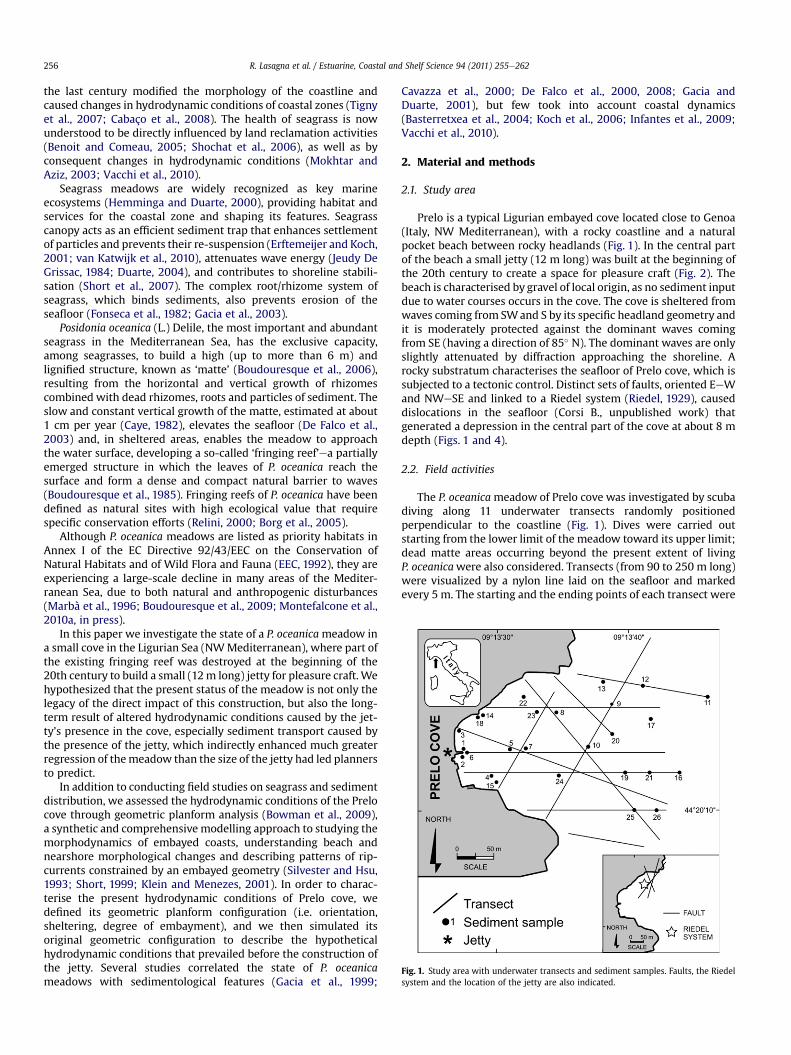
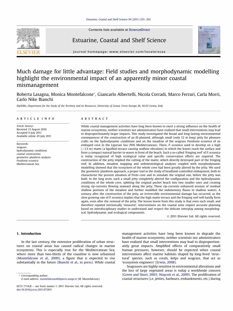
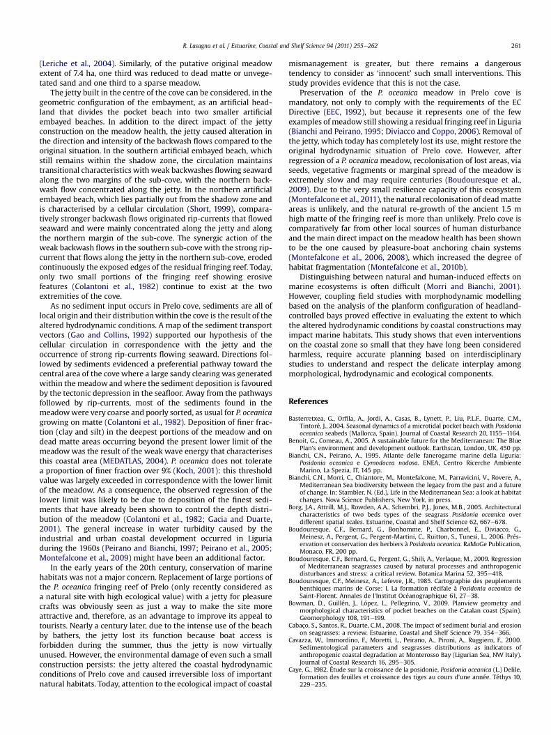
Fig. 1. Study area with underwater transects and sediment samples. Faults, the Riedelsystem and the location of the jetty are also indicated.
R. Lasagna et al. / Estuarine, Coastal and Shelf Science 94 (2011) 255e262256
the last century modified the morphology of the coastline andcaused changes in hydrodynamic conditions of coastal zones (Tignyet al., 2007; Cabaço et al., 2008). The health of seagrass is nowunderstood to be directly influenced by land reclamation activities(Benoit and Comeau, 2005; Shochat et al., 2006), as well as byconsequent changes in hydrodynamic conditions (Mokhtar andAziz, 2003; Vacchi et al., 2010).
Seagrass meadows are widely recognized as key marineecosystems (Hemminga and Duarte, 2000), providing habitat andservices for the coastal zone and shaping its features. Seagrasscanopy acts as an efficient sediment trap that enhances settlementof particles and prevents their re-suspension (Erftemeijer and Koch,2001; van Katwijk et al., 2010), attenuates wave energy (Jeudy DeGrissac, 1984; Duarte, 2004), and contributes to shoreline stabili-sation (Short et al., 2007). The complex root/rhizome system ofseagrass, which binds sediments, also prevents erosion of theseafloor (Fonseca et al., 1982; Gacia et al., 2003).
Posidonia oceanica (L.) Delile, the most important and abundantseagrass in the Mediterranean Sea, has the exclusive capacity,among seagrasses, to build a high (up to more than 6 m) andlignified structure, known as ‘matte’ (Boudouresque et al., 2006),resulting from the horizontal and vertical growth of rhizomescombined with dead rhizomes, roots and particles of sediment. Theslow and constant vertical growth of the matte, estimated at about1 cm per year (Caye, 1982), elevates the seafloor (De Falco et al.,2003) and, in sheltered areas, enables the meadow to approachthe water surface, developing a so-called ‘fringing reef’ea partiallyemerged structure in which the leaves of P. oceanica reach thesurface and form a dense and compact natural barrier to waves(Boudouresque et al., 1985). Fringing reefs of P. oceanica have beendefined as natural sites with high ecological value that requirespecific conservation efforts (Relini, 2000; Borg et al., 2005).
Although P. oceanica meadows are listed as priority habitats inAnnex I of the EC Directive 92/43/EEC on the Conservation ofNatural Habitats and of Wild Flora and Fauna (EEC, 1992), they areexperiencing a large-scale decline in many areas of the Mediter-ranean Sea, due to both natural and anthropogenic disturbances(Marbà et al., 1996; Boudouresque et al., 2009; Montefalcone et al.,2010a, in press).
In this paper we investigate the state of a P. oceanicameadow ina small cove in the Ligurian Sea (NWMediterranean), where part ofthe existing fringing reef was destroyed at the beginning of the20th century to build a small (12m long) jetty for pleasure craft. Wehypothesized that the present status of the meadow is not only thelegacy of the direct impact of this construction, but also the long-term result of altered hydrodynamic conditions caused by the jet-ty’s presence in the cove, especially sediment transport caused bythe presence of the jetty, which indirectly enhanced much greaterregression of themeadow than the size of the jetty had led plannersto predict.
In addition to conducting field studies on seagrass and sedimentdistribution, we assessed the hydrodynamic conditions of the Prelocove through geometric planform analysis (Bowman et al., 2009),a synthetic and comprehensive modelling approach to studying themorphodynamics of embayed coasts, understanding beach andnearshore morphological changes and describing patterns of rip-currents constrained by an embayed geometry (Silvester and Hsu,1993; Short, 1999; Klein and Menezes, 2001). In order to charac-terise the present hydrodynamic conditions of Prelo cove, wedefined its geometric planform configuration (i.e. orientation,sheltering, degree of embayment), and we then simulated itsoriginal geometric configuration to describe the hypotheticalhydrodynamic conditions that prevailed before the construction ofthe jetty. Several studies correlated the state of P. oceanicameadows with sedimentological features (Gacia et al., 1999;
Cavazza et al., 2000; De Falco et al., 2000, 2008; Gacia andDuarte, 2001), but few took into account coastal dynamics(Basterretxea et al., 2004; Koch et al., 2006; Infantes et al., 2009;Vacchi et al., 2010).
2. Material and methods
2.1. Study area
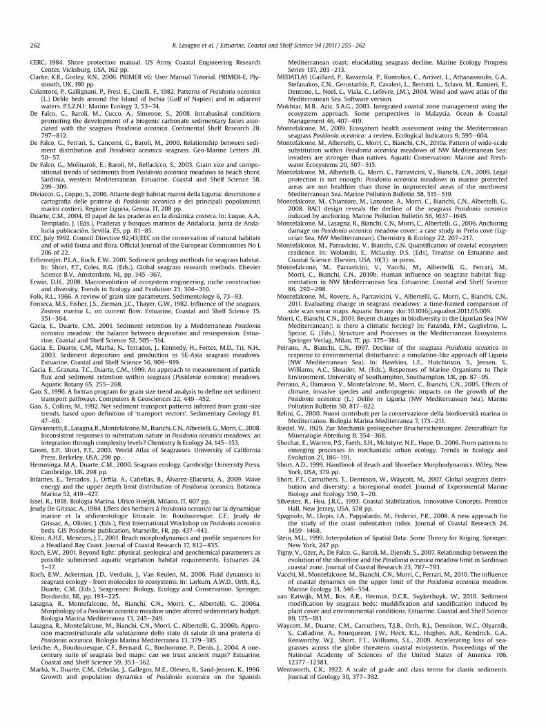
Prelo is a typical Ligurian embayed cove located close to Genoa(Italy, NW Mediterranean), with a rocky coastline and a naturalpocket beach between rocky headlands (Fig. 1). In the central partof the beach a small jetty (12 m long) was built at the beginning ofthe 20th century to create a space for pleasure craft (Fig. 2). Thebeach is characterised by gravel of local origin, as no sediment inputdue to water courses occurs in the cove. The cove is sheltered fromwaves coming from SWand S by its specific headland geometry andit is moderately protected against the dominant waves comingfrom SE (having a direction of 85� N). The dominant waves are onlyslightly attenuated by diffraction approaching the shoreline. Arocky substratum characterises the seafloor of Prelo cove, which issubjected to a tectonic control. Distinct sets of faults, oriented EeWand NWeSE and linked to a Riedel system (Riedel, 1929), causeddislocations in the seafloor (Corsi B., unpublished work) thatgenerated a depression in the central part of the cove at about 8 mdepth (Figs. 1 and 4).
2.2. Field activities
The P. oceanicameadow of Prelo cove was investigated by scubadiving along 11 underwater transects randomly positionedperpendicular to the coastline (Fig. 1). Dives were carried outstarting from the lower limit of the meadow toward its upper limit;dead matte areas occurring beyond the present extent of livingP. oceanicawere also considered. Transects (from 90 to 250 m long)were visualized by a nylon line laid on the seafloor and markedevery 5 m. The starting and the ending points of each transect were
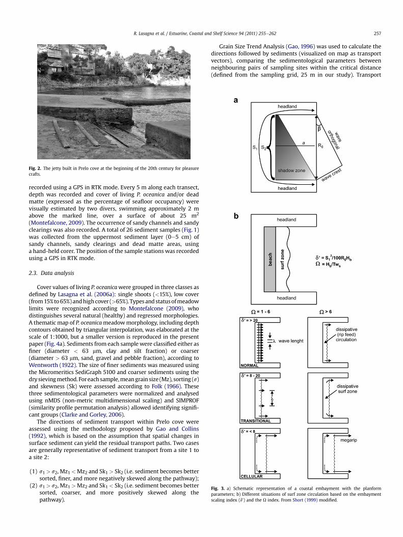
Fig. 3. a) Schematic representation of a coastal embayment with the planformparameters; b) Different situations of surf zone circulation based on the embaymentscaling index (d0) and the U index. From Short (1999) modified.
Fig. 2. The jetty built in Prelo cove at the beginning of the 20th century for pleasurecrafts.
R. Lasagna et al. / Estuarine, Coastal and Shelf Science 94 (2011) 255e262 257
recorded using a GPS in RTK mode. Every 5 m along each transect,depth was recorded and cover of living P. oceanica and/or deadmatte (expressed as the percentage of seafloor occupancy) werevisually estimated by two divers, swimming approximately 2 mabove the marked line, over a surface of about 25 m2
(Montefalcone, 2009). The occurrence of sandy channels and sandyclearings was also recorded. A total of 26 sediment samples (Fig. 1)was collected from the uppermost sediment layer (0e5 cm) ofsandy channels, sandy clearings and dead matte areas, usinga hand-held corer. The position of the sample stations was recordedusing a GPS in RTK mode.
2.3. Data analysis
Cover values of living P. oceanicawere grouped in three classes asdefined by Lasagna et al. (2006a): single shoots (<15%), low cover(from15%to65%)andhighcover (>65%). Types andstatusofmeadowlimits were recognized according to Montefalcone (2009), whodistinguishes several natural (healthy) and regressed morphologies.A thematic map of P. oceanicameadowmorphology, including depthcontours obtained by triangular interpolation, was elaborated at thescale of 1:1000, but a smaller version is reproduced in the presentpaper (Fig. 4a). Sediments from each samplewere classified either asfiner (diameter < 63 mm, clay and silt fraction) or coarser(diameter > 63 mm, sand, gravel and pebble fraction), according toWentworth (1922). The size of finer sediments was measured usingthe Micromeritics SediGraph 5100 and coarser sediments using thedrysievingmethod. Foreach sample,meangrain size (Mz), sorting (s)and skewness (Sk) were assessed according to Folk (1966). Thesethree sedimentological parameters were normalized and analysedusing nMDS (non-metric multidimensional scaling) and SIMPROF(similarity profile permutation analysis) allowed identifying signifi-cant groups (Clarke and Gorley, 2006).
The directions of sediment transport within Prelo cove wereassessed using the methodology proposed by Gao and Collins(1992), which is based on the assumption that spatial changes insurface sediment can yield the residual transport paths. Two casesare generally representative of sediment transport from a site 1 toa site 2:
(1) s1 > s2, Mz1 <Mz2 and Sk1 > Sk2 (i.e. sediment becomes bettersorted, finer, and more negatively skewed along the pathway);
(2) s1 > s2, Mz1 >Mz2 and Sk1 < Sk2 (i.e. sediment becomes bettersorted, coarser, and more positively skewed along thepathway).
Grain Size Trend Analysis (Gao, 1996) was used to calculate thedirections followed by sediments (visualized on map as transportvectors), comparing the sedimentological parameters betweenneighbouring pairs of sampling sites within the critical distance(defined from the sampling grid, 25 m in our study). Transport

Fig. 4. a) Map of the Posidonia oceanica meadow morphology; b) Map of the sedimentological features of Prelo cove (A ¼ very coarse sand; B ¼ coarse and medium sand; C ¼ fineand very fine sand); c) Map of the sediment transport vectors.
R. Lasagna et al. / Estuarine, Coastal and Shelf Science 94 (2011) 255e262258
vectors were interpolated in a regular grid of 1080 points by kriging(Stein, 1999). Two thematic maps showing sedimentologicalfeatures and sediment transport vectors in the study area wereelaborated at the original scale of 1:1000, but two smaller versionsare reproduced in the present paper (see Fig. 4b, c).
2.4. Morphodynamic modelling
Geometric planform analysis (Bowman et al., 2009) was used todefine the planform characteristics of the Prelo cove in twodifferent situations: (1) the present situation, where the jetty isviewed as an artificial headland that divides the embayed cove intotwo smaller sub-coves (the northern and the southern sub-coves)and the pocket beach in two smaller artificial pocket beaches; (2)the simulated original situation of Prelo before the jetty was built,with the whole embayed cove and pocket beach still occurring. Forboth situations (i.e. the present and the simulated), the following
two-dimensional planform parameters were measured from thetopographic map of Prelo, provided by the Liguria Region in scale1:5000 (Fig. 3a):
(1) headland spacing (R0), i.e. the length and orientation of thecove (or of the sub-cove), measured from its northern tosouthern margins;
(2) bay indentation (a), measured from R0 to the most pronouncedretreat of the cove (or sub-cove);
(3) length of the embayed shoreline (S1);(4) length of the embayed beach (S2).
From the four planform parameters above, three planformindices were computed for both situations:
(1) a/R0 to characterise the degree of embayment of the cove(Silvester and Hsu, 1993);
R. Lasagna et al. / Estuarine, Coastal and Shelf Science 94 (2011) 255e262 259
(2) S1/R0 to measure the indentation of the cove (Spagnolo et al.,2008), later classified according to the five categories sug-gested by Bowman et al. (2009);
(3) S2/S1 to measure the magnitude of the sediment fill in theembayment (Bowman et al., 2009).
In order to describe the surf zone circulation in both situations,the most significant annual wave height offshore (H0) and the waveperiod (T) were obtained from MEDATLAS (2004). The diffractedwave (Hd) was obtained by correcting H0 with respect to diffractionusing the formula
Hd ¼ H0=senß;
where b is the angle between the wave orthogonal and R0 (Fig. 3a).Similarly, to compute the incident breaking wave height (Hb) weapplied the formula
Hb ¼ffiffiffiffiffiffiffiffiffiffiffiffiffiffiffiffiffiffiffiffiffiffiffiffiffiffiffiffiffihH2d$ðR0=S1Þ
ir;
neglecting shoaling and bed friction (CERC, 1984). Finally, planformand hydrodynamic parameters were combined to measure twomorphodynamic indices for both the present situation with twoartificial embayed beaches and the simulated original whole beach(Fig. 3b):
(1) embayment scaling (d0), which relates the length of theembayed shoreline (S1) that adsorb energy (at a typical surfzone gradient of 0.01) to the incident breakingwave height (Hb)and the bay exposure (R0) and is computed by the formula(Short, 1999):
d0 ¼ S21=100 R0Hb;
(2) U index, which relates the incident breaking wave height (Hb)to the sediment fall velocity Ws (CERC, 1984), and is computedby the formula:
U ¼ Hb=TWs
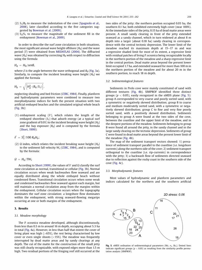
Fig. 5. nMDS ordination of sedimentological parameters (Mz, s1, Sk1). Dotted linesindicate significant groups (p < 0.05) as resulting from the similarity profile permu-tation analysis (SIMPROF).
According to Short (1999), the values of d0 and U classify the surfzone circulation as normal, transitional or cellular (Fig. 3b). Normalcirculation occurs when weak backwashes flow seaward and areequally distributed along the whole embayed beach withoutcondensed flows. Transitional circulation occurs when some weakand condensed backwashes flow seaward against each margin, butstill maintain a normal circulation away from the margins withinthe embayment. Cellular circulation occurs when the topographydominates the surf zone circulation: a longshore flow dominateswithin the embayment, with strong seaward-flowing megaripsoccurring at one or both margins of the embayment.
3. Results
3.1. Meadow morphology
The P. oceanica meadow developed, although discontinuously,from less than 0.5 m to around 16 m depth, occupying about 5.3 hain total (Fig. 4a). However, in less than half that extent the cover ofliving plant was high (>65%), the rest being characterised by lowcover or even single shoots (<15%). The meadow was frequentlyinterrupted by dead matte areas and by sandy clearings at anydepth. The cut of the matte for the construction of the small jettywas still clearly recognizable, with exposed edges more than 1.5 mhigh. Two residual portions of the fringing reef still occurred at the
two sides of the jetty: the northern portion occupied 0.03 ha, thesouthern 0.1 ha; both exhibited extremely high cover (near 100%).At the immediate sides of the jetty, 0.15 ha of deadmatte areas werepresent. A small sandy clearing in front of the jetty extendedseaward as a sandy channel, which in turn widened at about 8 mdepth into a larger (about 0.18 ha) sandy clearing in correspon-dence with the central tectonic depression. The lower limit of themeadow reached its maximum depth at 15e17 m and wasa regressive shaded limit for most of its extent, a regressive limitwith residual patches of living P. oceanica being recognizable locallyin the northern portion of the meadow and a sharp regressive limitin the central portion. Dead matte areas beyond the present lowerlimit occupied 1.7 ha, and extended seaward for more than 100m inthe northern portion of the meadow and for about 20 m in thesouthern portion, to reach 18 m depth.
3.2. Sedimentological features
Sediments in Prelo cove were mainly constituted of sand withdifferent textures (Fig. 4b). SIMPROF identified three distinctgroups (p < 0.05), easily recognized in the nMDS plane (Fig. 5):group A corresponded to very coarse and poorly sorted sand, witha symmetric or negatively skewed distribution; group B to coarseand medium moderately sorted sand, with a symmetric or nega-tively skewed distribution; group C to fine and very fine poorlysorted sand, with a positively skewed distribution. Sedimentsbelonging to group A were found at the two sides of the cove,between the coastline and the upper limit of the meadow, and inthe deepest portions of the meadow. Sediments belonging to groupB were found all around the jetty, in the sandy channel and in thelarge sandy clearing on the tectonic depression. Sediments of groupC were found in deadmatte areas beyond the present lower limit ofthe meadow (Fig. 4b).
The map of the sediment transport vectors showed: 1) preva-lence of sediment transport parallel to the coastline (i.e. longshorecurrents) along the northern side of the cove; 2) sediment transportorthogonal to the coastline (i.e. rip-currents) in correspondencewith the jetty; 3) a backwash flow of sediments directed seawarddue to reflection against the rocky coast in the southern side of thecove (Fig. 4c).
3.3. Morphodynamic features
Most values of hydrodynamic and planform parameters andindices calculated for the northern and the southern artificial

Table 1Values of hydrodynamic and planform parameters and indices measured for the whole embayed cove (simulated original situation) and for the northern and the southernartificial embayed sub-coves (present situation).
R0 (m) a (m) S1 (m) S2 (m) a/R0 S1/R0 S2/S1 H0 (m) Hd (m) T (sec) Ws (m s�1) Hb (m) d0 U
Whole 244 181 500 98 0.74 2.05 0.2 1.5 1.2 5 0.08 0.8 12.5 2.0North 57 20 86 45 0.35 1.51 0.5 1.5 0.8 5 0.08 0.6 2.1 1.4South 48 15 89 53 0.31 1.85 0.6 1.5 0.3 5 0.02 0.2 8.3 1.9
R. Lasagna et al. / Estuarine, Coastal and Shelf Science 94 (2011) 255e262260
pocket beaches (i.e. the present situation) and for the whole pocketbeach (i.e. the simulated original situation) differ greatly (Table 1).The two indices a/R0 and S1/R0 for the whole simulated beachdefine Prelo as an indented cove. The rocky headland in thesouthern side of the cove originates a wave shadow zone thatincludes the whole pocket beach (Figs. 3a and 6a) and, due todiffraction, reduces the wave height from H0 ¼ 1.5 to Hb ¼ 0.8(Table 1). The embayment scaling is high (d0 ¼ 12.5), whilst the Uindex is low (U ¼ 2.0), due to the coarser size of sediments. Thesetwo indices indicate a transitional surf zone circulation in thesimulated situation (Fig. 6b).
The two artificial pocket beaches of Prelo, in the present situa-tion, are both characterised by comparatively lower values of a/R0and S1/R0 and by higher values of S2/S1 than the beach in thesimulated situation. The southern and northern artificial sub-covesare defined as low-indented; the former still lies inside the waveshadow zone and is characterised by a transitional surf zonecirculation (d0 ¼ 8.3;U¼ 1.9), the latter lies only partially within thewave shadow zone, so that a comparatively higher value of thediffracted waves (Hd) and lower values of the embayment scaling(d0 ¼ 2.1) and the U index (U ¼ 1.4) define a cellular surf zonecirculation in this sub-cove (Fig. 6c).
4. Discussion
Both the present structure and health state of the P. oceanicameadow of Prelo showed influence by the morphological configu-ration and the hydrodynamic conditions of the cove, especially inshallow waters subjected to a surf zone circulation (Vacchi et al.,2010). Analysing the configuration of the headland-controlled
Fig. 6. a) The shadow zone originated by the southern headland in Prelo cove; b) Simulaembayed cove before the jetty construction; c) Present situation of Prelo with a transitionalof rip-currents in the northern artificial sub-coves.
embayment of Prelo with the geometric planform approach byBowman et al. (2009), we were able to describe the morphody-namic behaviour of the pocket beach. Originally, in the simulatedsituation existing before the jetty construction when the wholepocket beach still occurred, the development of the P. oceanicameadow was likely to be mostly influenced by substratum nature(Lasagna et al., 2006b; Giovannetti et al., 2008) rather than bywater movement. The low wave energy due to wind exposures, theshadow zone created by the southern rocky headland, and theweak backwashes flowing seaward as is typical of the transitionalsurf zone circulation (Short, 1999) allowed the shallow portions ofthe meadow to develop in a relatively sheltered area and toapproach shore. In this situation the meadow had been able tobuild a high matte (>1.5 m high, needing more than one and halfcenturies to grow) that reached the water surface to form thefringing reef (Bianchi and Peirano, 1995).
Almost a century ago, Issel (1918) described the P. oceanicameadows of the area as a continuous ‘green belt’ along the coast-line, with plants growing close to the shore and leaves reaching thewater surface. Issel’s description corresponds well to what shouldhave been the situation of Prelo before the jetty was built: summingthe present day extent of living P. oceanica with the extent of deadmatte and sandy clearings, it is possible to provide an estimate ofthe original situation. It is thus more than likely that, before thecutting of the matte, the fringing reef was a continuous structureextending for about 0.4 ha along the whole pocket beach. Less thanone third of it was found during the present study, the remainderhaving been directly cut away or indirectly reduced to exposeddead matte. Occurrence of dead matte areas around the jetty wasthe clearest evidence of the past existence of this fringing reef
tion of the transitional circulation with weak backwash flows occurring in the wholecirculation in the southern artificial sub-cove and a cellular circulation with occurrence
R. Lasagna et al. / Estuarine, Coastal and Shelf Science 94 (2011) 255e262 261
(Leriche et al., 2004). Similarly, of the putative original meadowextent of 7.4 ha, one third was reduced to dead matte or unvege-tated sand and one third to a sparse meadow.
The jetty built in the centre of the cove can be considered, in thegeometric configuration of the embayment, as an artificial head-land that divides the pocket beach into two smaller artificialembayed beaches. In addition to the direct impact of the jettyconstruction on the meadow health, the jetty caused alteration inthe direction and intensity of the backwash flows compared to theoriginal situation. In the southern artificial embayed beach, whichstill remains within the shadow zone, the circulation maintainstransitional characteristics with weak backwashes flowing seawardalong the two margins of the sub-cove, with the northern back-wash flow concentrated along the jetty. In the northern artificialembayed beach, which lies partially out from the shadow zone andis characterised by a cellular circulation (Short, 1999), compara-tively stronger backwash flows originated rip-currents that flowedseaward and were mainly concentrated along the jetty and alongthe northern margin of the sub-cove. The synergic action of theweak backwash flows in the southern sub-covewith the strong rip-current that flows along the jetty in the northern sub-cove, erodedcontinuously the exposed edges of the residual fringing reef. Today,only two small portions of the fringing reef showing erosivefeatures (Colantoni et al., 1982) continue to exist at the twoextremities of the cove.
As no sediment input occurs in Prelo cove, sediments are all oflocal origin and their distributionwithin the cove is the result of thealtered hydrodynamic conditions. A map of the sediment transportvectors (Gao and Collins, 1992) supported our hypothesis of thecellular circulation in correspondence with the jetty and theoccurrence of strong rip-currents flowing seaward. Directions fol-lowed by sediments evidenced a preferential pathway toward thecentral area of the cove where a large sandy clearing was generatedwithin the meadow andwhere the sediment deposition is favouredby the tectonic depression in the seafloor. Away from the pathwaysfollowed by rip-currents, most of the sediments found in themeadowwere very coarse and poorly sorted, as usual for P. oceanicagrowing on matte (Colantoni et al., 1982). Deposition of finer frac-tion (clay and silt) in the deepest portions of the meadow and ondead matte areas occurring beyond the present lower limit of themeadowwas the result of the weak wave energy that characterisesthis coastal area (MEDATLAS, 2004). P. oceanica does not toleratea proportion of finer fraction over 9% (Koch, 2001): this thresholdvalue was largely exceeded in correspondence with the lower limitof the meadow. As a consequence, the observed regression of thelower limit was likely to be due to deposition of the finest sedi-ments that have already been shown to control the depth distri-bution of the meadow (Colantoni et al., 1982; Gacia and Duarte,2001). The general increase in water turbidity caused by theindustrial and urban coastal development occurred in Liguriaduring the 1960s (Peirano and Bianchi, 1997; Peirano et al., 2005;Montefalcone et al., 2009) might have been an additional factor.
In the early years of the 20th century, conservation of marinehabitats was not a major concern. Replacement of large portions ofthe P. oceanica fringing reef of Prelo (only recently considered asa natural site with high ecological value) with a jetty for pleasurecrafts was obviously seen as just a way to make the site moreattractive and, therefore, as an advantage to improve its appeal totourists. Nearly a century later, due to the intense use of the beachby bathers, the jetty lost its function because boat access isforbidden during the summer, thus the jetty is now virtuallyunused. However, the environmental damage of even such a smallconstruction persists: the jetty altered the coastal hydrodynamicconditions of Prelo cove and caused irreversible loss of importantnatural habitats. Today, attention to the ecological impact of coastal
mismanagement is greater, but there remains a dangeroustendency to consider as ‘innocent’ such small interventions. Thisstudy provides evidence that this is not the case.
Preservation of the P. oceanica meadow in Prelo cove ismandatory, not only to comply with the requirements of the ECDirective (EEC, 1992), but because it represents one of the fewexamples of meadow still showing a residual fringing reef in Liguria(Bianchi and Peirano, 1995; Diviacco and Coppo, 2006). Removal ofthe jetty, which today has completely lost its use, might restore theoriginal hydrodynamic situation of Prelo cove. However, afterregression of a P. oceanica meadow, recolonisation of lost areas, viaseeds, vegetative fragments or marginal spread of the meadow isextremely slow and may require centuries (Boudouresque et al.,2009). Due to the very small resilience capacity of this ecosystem(Montefalcone et al., 2011), the natural recolonisation of deadmatteareas is unlikely, and the natural re-growth of the ancient 1.5 mhigh matte of the fringing reef is more than unlikely. Prelo cove iscomparatively far from other local sources of human disturbanceand the main direct impact on the meadow health has been shownto be the one caused by pleasure-boat anchoring chain systems(Montefalcone et al., 2006, 2008), which increased the degree ofhabitat fragmentation (Montefalcone et al., 2010b).
Distinguishing between natural and human-induced effects onmarine ecosystems is often difficult (Morri and Bianchi, 2001).However, coupling field studies with morphodynamic modellingbased on the analysis of the planform configuration of headland-controlled bays proved effective in evaluating the extent to whichthe altered hydrodynamic conditions by coastal constructions mayimpact marine habitats. This study shows that even interventionson the coastal zone so small that they have long been consideredharmless, require accurate planning based on interdisciplinarystudies to understand and respect the delicate interplay amongmorphological, hydrodynamic and ecological components.
References
Basterretxea, G., Orfila, A., Jordi, A., Casas, B., Lynett, P., Liu, P.L.F., Duarte, C.M.,Tintoré, J., 2004. Seasonal dynamics of a microtidal pocket beach with Posidoniaoceanica seabeds (Mallorca, Spain). Journal of Coastal Research 20, 1155e1164.
Benoit, G., Comeau, A., 2005. A sustainable future for the Mediterranean: The BluePlan’s environment and development outlook. Earthscan, London, UK, 450 pp.
Bianchi, C.N., Peirano, A., 1995. Atlante delle fanerogame marine della Liguria:Posidonia oceanica e Cymodocea nodosa. ENEA, Centro Ricerche AmbienteMarino, La Spezia, IT, 145 pp.
Bianchi, C.N., Morri, C., Chiantore, M., Montefalcone, M., Parravicini, V., Rovere, A.,Mediterranean Sea biodiversity between the legacy from the past and a futureof change. In: Stambler, N. (Ed.), Life in the Mediterranean Sea: a look at habitatchanges. Nova Science Publishers, New York, in press.
Borg, J.A., Attrill, M.J., Rowden, A.A., Schembri, P.J., Jones, M.B., 2005. Architecturalcharacteristics of two beds types of the seagrass Posidonia oceanica overdifferent spatial scales. Estuarine, Coastal and Shelf Science 62, 667e678.
Boudouresque, C.F., Bernard, G., Bonhomme, P., Charbonnel, E., Diviacco, G.,Meinesz, A., Pergent, G., Pergent-Martini, C., Ruitton, S., Tunesi, L., 2006. Prés-ervation et conservation des herbiers à Posidonia oceanica. RaMoGe Publication,Monaco, FR, 200 pp.
Boudouresque, C.F., Bernard, G., Pergent, G., Shili, A., Verlaque, M., 2009. Regressionof Mediterranean seagrasses caused by natural processes and anthropogenicdisturbances and stress: a critical review. Botanica Marina 52, 395e418.
Boudouresque, C.F., Meinesz, A., Lefevre, J.R., 1985. Cartographie des peuplementsbenthiques marins de Corse: I. La formation récifale à Posidonia oceanica deSaint-Florent. Annales de l’Institut Océanographique 61, 27e38.
Bowman, D., Guillén, J., López, L., Pellegrino, V., 2009. Planview geometry andmorphological characteristics of pocket beaches on the Catalan coast (Spain).Geomorphology 108, 191e199.
Cabaço, S., Santos, R., Duarte, C.M., 2008. The impact of sediment burial and erosionon seagrasses: a review. Estuarine, Coastal and Shelf Science 79, 354e366.
Cavazza, W., Immordino, F., Moretti, L., Peirano, A., Pironi, A., Ruggiero, F., 2000.Sedimentological parameters and seagrasses distributions as indicators ofanthropogenic coastal degradation at Monterosso Bay (Ligurian Sea, NW Italy).Journal of Coastal Research 16, 295e305.
Caye, G., 1982. Étude sur la croissance de la posidonie, Posidonia oceanica (L.) Delile,formation des feuilles et croissance des tiges au cours d’une année. Téthys 10,229e235.
R. Lasagna et al. / Estuarine, Coastal and Shelf Science 94 (2011) 255e262262
CERC, 1984. Shore protection manual. US Army Coastal Engineering ResearchCenter, Vicksburg, USA, 162 pp.
Clarke, K.R., Gorley, R.N., 2006. PRIMER v6: User Manual Tutorial. PRIMER-E, Ply-mouth, UK, 190 pp.
Colantoni, P., Gallignani, P., Fresi, E., Cinelli, F., 1982. Patterns of Posidonia oceanica(L.) Delile beds around the Island of Ischia (Gulf of Naples) and in adjacentwaters. P.S.Z.N.I: Marine Ecology 3, 53e74.
De Falco, G., Baroli, M., Cucco, A., Simeone, S., 2008. Intrabasinal conditionspromoting the development of a biogenic carbonate sedimentary facies asso-ciated with the seagrass Posidonia oceanica. Continental Shelf Research 28,797e812.
De Falco, G., Ferrari, S., Cancemi, G., Baroli, M., 2000. Relationship between sedi-ment distribution and Posidonia oceanica seagrass. Geo-Marine Letters 20,50e57.
De Falco, G., Molinaroli, E., Baroli, M., Bellacicco, S., 2003. Grain size and compo-sitional trends of sediments from Posidonia oceanica meadows to beach shore,Sardinia, western Mediterranean. Estuarine, Coastal and Shelf Science 58,299e309.
Diviacco, G., Coppo, S., 2006. Atlante degli habitat marini della Liguria: descrizione ecartografia delle praterie di Posidonia oceanica e dei principali popolamentimarini costieri. Regione Liguria, Genoa, IT, 208 pp.
Duarte, C.M., 2004. El papel de las praderas en la dinámica costera. In: Luque, A.A.,Templado, J. (Eds.), Praderas y bosques marinos de Andalucía. Junta de Anda-lucía publicaciòn, Sevilla, ES, pp. 81e85.
EEC, July 1992. Council Directive 92/43/EEC on the conservation of natural habitatsand of wild fauna and flora. Official Journal of the European Communities No L206 of 22.
Erftemeijer, P.L.A., Koch, E.W., 2001. Sediment geology methods for seagrass habitat.In: Short, F.T., Coles, R.G. (Eds.), Global seagrass research methods. ElsevierScience B.V., Amsterdam, NL, pp. 345e367.
Erwin, D.H., 2008. Macroevolution of ecosystem engineering, niche constructionand diversity. Trends in Ecology and Evolution 23, 304e310.
Folk, R.L., 1966. A review of grain size parameters. Sedimentology 6, 73e93.Fonseca, M.S., Fisher, J.S., Zieman, J.C., Thayer, G.W., 1982. Influence of the seagrass,
Zostera marina L., on current flow. Estuarine, Coastal and Shelf Science 15,351e364.
Gacia, E., Duarte, C.M., 2001. Sediment retention by a Mediterranean Posidoniaoceanica meadow: the balance between deposition and resuspension. Estua-rine, Coastal and Shelf Science 52, 505e514.
Gacia, E., Duarte, C.M., Marba, N., Terrados, J., Kennedy, H., Fortes, M.D., Tri, N.H.,2003. Sediment deposition and production in SE-Asia seagrass meadows.Estuarine, Coastal and Shelf Science 56, 909e919.
Gacia, E., Granata, T.C., Duarte, C.M., 1999. An approach to measurement of particleflux and sediment retention within seagrass (Posidonia oceanica) meadows.Aquatic Botany 65, 255e268.
Gao, S., 1996. A fortran program for grain size trend analysis to define net sedimenttransport pathways. Computers & Geosciences 22, 449e452.
Gao, S., Collins, M., 1992. Net sediment transport patterns inferred from grain-sizetrends, based upon definition of ‘transport vectors’. Sedimentary Geology 81,47e60.
Giovannetti, E., Lasagna,R.,Montefalcone,M., Bianchi, C.N.,Albertelli, G.,Morri, C., 2008.Inconsistent responses to substratum nature in Posidonia oceanica meadows: anintegration through complexity levels? Chemistry & Ecology 24, 145e153.
Green, E.P., Short, F.T., 2003. World Atlas of Seagrasses. University of CaliforniaPress, Berkeley, USA, 298 pp.
Hemminga, M.A., Duarte, C.M., 2000. Seagrass ecology. Cambridge University Press,Cambridge, UK, 298 pp.
Infantes, E., Terrados, J., Orfila, A., Cañellas, B., Álvarez-Ellacuria, A., 2009. Waveenergy and the upper depth limit distribution of Posidonia oceanica. BotanicaMarina 52, 419e427.
Issel, R., 1918. Biologia Marina. Ulrico Hoepli, Milano, IT, 607 pp.Jeudy De Grissac, A., 1984. Effets des herbiers à Posidonia oceanica sur la dynamique
marine et la sédimentologie littorale. In: Boudouresque, C.F., Jeudy deGrissac, A., Olivier, J. (Eds.), First International Workshop on Posidonia oceanicabeds. GIS Posidonie publication, Marseille, FR, pp. 437e443.
Klein, A.H.F., Menezes, J.T., 2001. Beach morphodynamics and profile sequences fora Headland Bay Coast. Journal of Coastal Research 17, 812e835.
Koch, E.W., 2001. Beyond light: physical, geological and geochemical parameters aspossible submersed aquatic vegetation habitat requirements. Estuaries 24,1e17.
Koch, E.W., Ackerman, J.D., Verduin, J., Van Keulen, M., 2006. Fluid dynamics inseagrass ecology - from molecules to ecosystems. In: Larkum, A.W.D., Orth, R.J.,Duarte, C.M. (Eds.), Seagrasses: Biology, Ecology and Conservation. Springer,Dordrecht, NL, pp. 193e225.
Lasagna, R., Montefalcone, M., Bianchi, C.N., Morri, C., Albertelli, G., 2006a.Morphology of a Posidonia oceanicameadow under altered sedimentary budget.Biologia Marina Mediterranea 13, 245e249.
Lasagna, R., Montefalcone, M., Bianchi, C.N., Morri, C., Albertelli, G., 2006b. Appro-ccio macrostrutturale alla valutazione dello stato di salute di una prateria diPosidonia oceanica. Biologia Marina Mediterranea 13, 379e385.
Leriche, A., Boudouresque, C.F., Bernard, G., Bonhomme, P., Denis, J., 2004. A one-century suite of seagrass bed maps: can we trust ancient maps? Estuarine,Coastal and Shelf Science 59, 353e362.
Marbà, N., Duarte, C.M., Cebriàn, J., Gallegos, M.E., Olesen, B., Sand-Jensen, K., 1996.Growth and population dynamics of Posidonia oceanica on the Spanish
Mediterranean coast: elucidating seagrass decline. Marine Ecology ProgressSeries 137, 203e213.
MEDATLAS (Gaillard, P., Ravazzola, P., Kontolios, C., Arrivet, L., Athanassoulis, G.A.,Stefanakos, C.N., Gerostathis, P., Cavaleri, L., Bertotti, L., Sclavo, M., Ramieri, E.,Dentone, L., Noel, C., Viala, C., Lefevre, J.M.), 2004. Wind and wave atlas of theMediterranean Sea. Software version.
Mokhtar, M.B., Aziz, S.A.G., 2003. Integrated coastal zone management using theecosystem approach. Some perspectives in Malaysia. Ocean & CoastalManagement 46, 407e419.
Montefalcone, M., 2009. Ecosystem health assessment using the Mediterraneanseagrass Posidonia oceanica: a review. Ecological Indicators 9, 595e604.
Montefalcone, M., Albertelli, G., Morri, C., Bianchi, C.N., 2010a. Pattern of wide-scalesubstitution within Posidonia oceanica meadows of NW Mediterranean Sea:invaders are stronger than natives. Aquatic Conservation: Marine and Fresh-water Ecosystems 20, 507e515.
Montefalcone, M., Albertelli, G., Morri, C., Parravicini, V., Bianchi, C.N., 2009. Legalprotection is not enough: Posidonia oceanica meadows in marine protectedareas are not healthier than those in unprotected areas of the northwestMediterranean Sea. Marine Pollution Bulletin 58, 515e519.
Montefalcone, M., Chiantore, M., Lanzone, A., Morri, C., Bianchi, C.N., Albertelli, G.,2008. BACI design reveals the decline of the seagrass Posidonia oceanicainduced by anchoring. Marine Pollution Bulletin 56, 1637e1645.
Montefalcone, M., Lasagna, R., Bianchi, C.N., Morri, C., Albertelli, G., 2006. Anchoringdamage on Posidonia oceanica meadow cover: a case study in Prelo cove (Lig-urian Sea, NW Mediterranean). Chemistry & Ecology 22, 207e217.
Montefalcone, M., Parravicini, V., Bianchi, C.N. Quantification of coastal ecosystemresilience. In: Wolanski, E., McLusky, D.S. (Eds), Treatise on Estuarine andCoastal Science. Elsevier, USA, 10(3): in press.
Montefalcone, M., Parravicini, V., Vacchi, M., Albertelli, G., Ferrari, M.,Morri, C., Bianchi, C.N., 2010b. Human influence on seagrass habitat frag-mentation in NW Mediterranean Sea. Estuarine, Coastal and Shelf Science86, 292e298.
Montefalcone, M., Rovere, A., Parravicini, V., Albertelli, G., Morri, C., Bianchi, C.N.,2011. Evaluating change in seagrass meadows: a time-framed comparison ofside scan sonar maps. Aquatic Botany. doi:10.1016/j.aquabot.2011.05.009.
Morri, C., Bianchi, C.N., 2001. Recent changes in biodiversity in the Ligurian Sea (NWMediterranean): is there a climatic forcing? In: Faranda, F.M., Guglielmo, L.,Spezie, G. (Eds.), Structure and Processes in the Mediterranean Ecosystems.Springer Verlag, Milan, IT, pp. 375e384.
Peirano, A., Bianchi, C.N., 1997. Decline of the seagrass Posidonia oceanica inresponse to environmental disturbance: a simulation-like approach off Liguria(NW Mediterranean Sea). In: Hawkins, L.E., Hutchinson, S., Jensen, S.,Williams, A.C., Sheader, M. (Eds.), Responses of Marine Organisms to TheirEnvironment. University of Southampton, Southampton, UK, pp. 87e95.
Peirano, A., Damasso, V., Montefalcone, M., Morri, C., Bianchi, C.N., 2005. Effects ofclimate, invasive species and anthropogenic impacts on the growth of thePosidonia oceanica (L.) Delile in Liguria (NW Mediterranean Sea). MarinePollution Bulletin 50, 817e822.
Relini, G., 2000. Nuovi contributi per la conservazione della biodiversità marina inMediterraneo. Biologia Marina Mediterranea 7, 173e211.
Riedel, W., 1929. Zur Mechanik geologischer Brucherscheinungen. Zentralblatt furMineralogie Abteilung B, 354e368.
Shochat, E., Warren, P.S., Faeth, S.H., McIntyre, N.E., Hope, D., 2006. From patterns toemerging processes in mechanistic urban ecology. Trends in Ecology andEvolution 21, 186e191.
Short, A.D., 1999. Handbook of Beach and Shoreface Morphodynamics. Wiley, NewYork, USA, 379 pp.
Short, F.T., Carruthers, T., Dennison, W., Waycott, M., 2007. Global seagrass distri-bution and diversity: a bioregional model. Journal of Experimental MarineBiology and Ecology 350, 3e20.
Silvester, R., Hsu, J.R.C., 1993. Coastal Stabilization, Innovative Concepts. PrenticeHall, New Jersey, USA, 578 pp.
Spagnolo, M., Llopis, I.A., Pappalardo, M., Federici, P.R., 2008. A new approach forthe study of the coast indentation index. Journal of Coastal Research 24,1459e1468.
Stein, M.L., 1999. Interpolation of Spatial Data: Some Theory for Kriging. Springer,New York, 247 pp.
Tigny, V., Ozer, A., De Falco, G., Baroli, M., Djenidi, S., 2007. Relationship between theevolution of the shoreline and the Posidonia oceanicameadow limit in Sardiniancoastal zone. Journal of Coastal Research 23, 787e793.
Vacchi, M., Montefalcone, M., Bianchi, C.N., Morri, C., Ferrari, M., 2010. The influenceof coastal dynamics on the upper limit of the Posidonia oceanica meadow.Marine Ecology 31, 546e554.
van Katwijk, M.M., Bos, A.R., Hermus, D.C.R., Suykerbuyk, W., 2010. Sedimentmodification by seagrass beds: muddification and sandification induced byplant cover and environmental conditions. Estuarine. Coastal and Shelf Science89, 175e181.
Waycott, M., Duarte, C.M., Carruthers, T.J.B., Orth, R.J., Dennison, W.C., Olyarnik,S., Calladine, A., Fourqurean, J.W., Heck, K.L., Hughes, A.R., Kendrick, G.A.,Kenworthy, W.J., Short, F.T., Williams, S.L., 2009. Accelerating loss of sea-grasses across the globe threatens coastal ecosystems. Proceedings of theNational Academy of Sciences of the United States of America 106,12377e12381.
Wentworth, C.K., 1922. A scale of grade and class terms for clastic sediments.Journal of Geology 30, 377e392.