mr s cresswell residential development at fall road ... fall road, heanor... · fall road, heanor...
TRANSCRIPT
Bancroft Consulting Ltd, Jarodale House, 7 Gregory Boulevard
Nottingham, NG7 6LB
Tel: 0115 9602919
Email: [email protected]
AUTHOR: ATB CHECKED: CJB APPROVED: CJB STATUS: DRAFT
REPORT REF: F11067 Fall Road, Heanor Residential Travel Plan.doc
DOCUMENT ISSUE RECORD
REVISION DATE DESCRIPTION
DRAFT NOV 2011 Draft document issued to Project Team for comments
Mr S Cresswell
Residential Development at Fall Road, Heanor
Residential Travel Plan
November 2011
DRAFT FOR
COMMENTS
RESIDENTIAL DEVELOPMENT FALL ROAD , HEANOR RESIDENTIAL TRAVEL PLAN NOVEMBER 2011
F11067 Fall Road, Heanor Residential Travel Plan.doc
CONTENTS Page Number
1.0 INTRODUCTION 1 2.0 BACKGROUND INFORMATION 3 3.0 OBJECTIVES 11 4.0 ACTIONS FOR ACHIEVING OBJECTIVES 12 5.0 TARGETS AND MONITORING 17 TABLES
Table 1 Details of local bus services (contained after report text)
Table 2 Travel Plan Objectives
Table 3 Summary of Travel Plan measures FIGURES Figure 1 Site location and nearby pedestrian crossing facilities
Figure 2 Pedestrian isochrone (2 kilometres)
Figure 3 Cyclist catchment area (5 kilometres)
Figure 4 Local bus routes
APPENDICES
Appendix A Sample residential travel survey
DRAFT FOR
COMMENTS
RESIDENTIAL DEVELOPMENT FALL ROAD, HEANOR RESIDENTIAL TRAVEL PLAN NOVEMBER 2011
F11067 Fall Road, Heanor Residential Travel Plan.doc 1
1.0 INTRODUCTION
1.1 This Residential Travel Plan has been prepared on behalf of Mr S Cresswell to
accompany an outline planning application for up to 240 dwellings on land to the
north of Fall Road in Heanor, Derbyshire. It will form the first stage in a series of
assessments and initiatives to encourage sustainable travel at the proposed
residential development.
1.2 According to the document ‘Guidance on Transport Assessment’ (DfT, March
2007), a Travel Plan (TP) is:
“a package of site-specific initiatives aimed at improving the
availability and choice of travel modes associated with any
development. It may also promote practices or policies that reduce
the need for travel. TPs are becoming an increasingly important tool
in the delivery of sustainable outcomes. They provide, together with
transport assessments, the mechanism for assessing and managing
access to sites. In addition, they can help improve accessibility, both
to and from the site, and to local amenities and services.”
(Para 4.80, Guidance on Transport Assessment, DfT, March 2007)
1.3 The objective of this Residential Travel Plan is to set out the developer’s
commitment to encouraging non-car travel at the proposed development, thereby
satisfying the requirements of both local and national planning policy. It should
be noted that the applicant for the proposed development may not be the
eventual developer, therefore this document sets out a general commitment to
encouraging sustainable travel, rather than fixing the developer to specific tasks.
1.4 At this stage the point of contact for any queries or further information relating to
the Travel Plan will be Andrew Braun at Bancroft Consulting (see details below).
Once the development commences, the developer will assume ownership of the
document and be responsible for implementing and monitoring the Travel Plan.
Fall Road, Heanor Residential Travel Plan Contact
Andrew Braun
Senior Engineer
Bancroft Consulting
DRAFT FOR
COMMENTS
RESIDENTIAL DEVELOPMENT FALL ROAD, HEANOR RESIDENTIAL TRAVEL PLAN NOVEMBER 2011
F11067 Fall Road, Heanor Residential Travel Plan.doc 2
Jarodale House
7 Gregory Boulevard
Nottingham
NG7 6LB
Tel: 0115 9626503
Email: [email protected]
1.5 In practice, it is impractical to expect a residential development to be approached
in the same way as a commercial development Travel Plan, as it is virtually
impossible to impose and enforce specific targets that relate to the ongoing
reduction of single occupancy car travel at a private residential development.
Consequently, the aim of this Travel Plan is to set out the existing opportunities
for non-car travel at the site, along with an indication of the potential modal splits
and actions that could be undertaken by the future developer to influence the
travel patterns of residents from the first day of their occupation.
1.6 A Scoping Study and subsequent Transport Assessment have also been
completed in support of the proposed development, with the Transport
Assessment to be submitted as part of the planning application. Where
appropriate, this Residential Travel Plan adopts the findings of the Transport
Assessment, particularly in respect of the proposed infrastructure and person trip
generation.
DRAFT FOR
COMMENTS

RESIDENTIAL DEVELOPMENT FALL ROAD, HEANOR RESIDENTIAL TRAVEL PLAN NOVEMBER 2011
F11067 Fall Road, Heanor Residential Travel Plan.doc 3
2.0 BACKGROUND INFORMATION
Site location
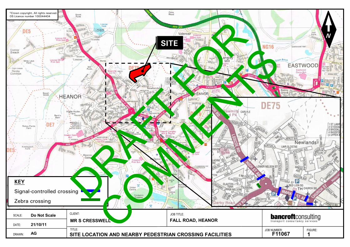
2.1 The site located to the north of Fall Road, at the northern edge of Heanor in
Derbyshire. It measures approximately 5.5 hectares in area and mostly
comprises undeveloped land, although there are 5 existing dwellings at the
southern end of the site at the eastern end of Fall Road, with several other
buildings with various informal uses to the rear of these properties within the site.
The site is bound by residential properties on Fall Road to the south, allotments
and undeveloped land to the west, and undeveloped land to the north and east.
Its location is shown in Figure 1, which also highlights the surrounding pedestrian
crossing facilities.
2.2 The area surrounding the site primarily comprises residential dwellings to the
south within Heanor, along with a large amount of retail and employment
development in the Town Centre, including a Tesco Superstore and the Heanor
Retail Park, as well as the Heanor Gate Industrial Estate to the south-west.
Further afield, the immediate surrounding area is mainly rural, beyond which
there are several other towns, such as Langley Mill 1 kilometre to the west, Ripley
5 kilometres to the north-west, and Ilkeston 6 kilometres to the south-east.
Description of the proposed development
2.3 The proposed residential development comprises up to 240 dwellings, with
vehicular access via an extension of Fall Road into the site. In addition, a
dedicated pedestrian/cyclist link would also be provided further south along Fall
Road. It is anticipated that the opening year for the development would be 2016.
2.4 The key findings of the Transport Assessment were as follows:
• The proposed development would generate the following peak hour and daily
traffic increases:
� morning peak 44 arrive 102 depart 146 total
� evening peak 90 arrive 58 depart 148 total
� daily 624 arrive 643 depart 1267 total
DRAFT FOR
COMMENTS

RESIDENTIAL DEVELOPMENT FALL ROAD, HEANOR RESIDENTIAL TRAVEL PLAN NOVEMBER 2011
F11067 Fall Road, Heanor Residential Travel Plan.doc 4
• The proposed development should provide a minimum of 480 of-street car
parking spaces.
• The proposed development traffic increases would not result in any
detrimental impact on the surrounding highway network.
• The following modal splits would be applicable to the site:
� by underground, metro, light rail or train 0.1%
� by train 0.5%
� by bus 6.2%
� by motorcycle/scooter/moped 1.5%
� by car/van (as driver) 67.2%
� by car/van (as passenger) 8.7%
� by taxi or minicab 0.3%
� on bicycle 1.9%
� on foot 13.4%
� other 0.2%
• Based on the above modal split and the traffic generation calculations, the
proposed development would generate the following peak hour and daily
person trips by each mode:
peak hour daily
� by underground, metro, light rail, or tram 0 2
� by train 1 9
� by bus 14 117
� by motor cycle/scooter/moped 3 28
� by car/van (as driver) 148 1267
� by car/van (as passenger) 19 164
� by taxi or minicab 1 6
� by bicycle 4 36
� on foot 30 253
� other 0 4
• The proposed development would be well placed to accommodate travel by
non-car modes such as walking, cycling, and public transport. Any increases
in person trips could be satisfactorily met through the existing infrastructure.
Any future site masterplan should include suitable pedestrian and cyclist links,
such as the one proposed at Fall Road, that connects the existing
DRAFT FOR
COMMENTS
RESIDENTIAL DEVELOPMENT FALL ROAD, HEANOR RESIDENTIAL TRAVEL PLAN NOVEMBER 2011
F11067 Fall Road, Heanor Residential Travel Plan.doc 5
infrastructure to a comprehensive network of footways and crossings along
key desire lines within the site.
Pedestrian accessibility issues
2.5 Opportunities for walking to the site are excellent. It is generally recognised that
two kilometres represents the maximum preferred walking distance for
commuting trips. Figure 2 shows a 2 kilometres pedestrian isochrone from the
site, which demonstrates that the majority of Heanor, including the Town Centre,
would be within a reasonable walking distance. This catchment area includes a
large amount of retail and employment development, such as the Tesco
superstore, Heanor Retail Park, and the High Street. It also includes a post office
and several public houses, plus a number of schools and colleges that are either
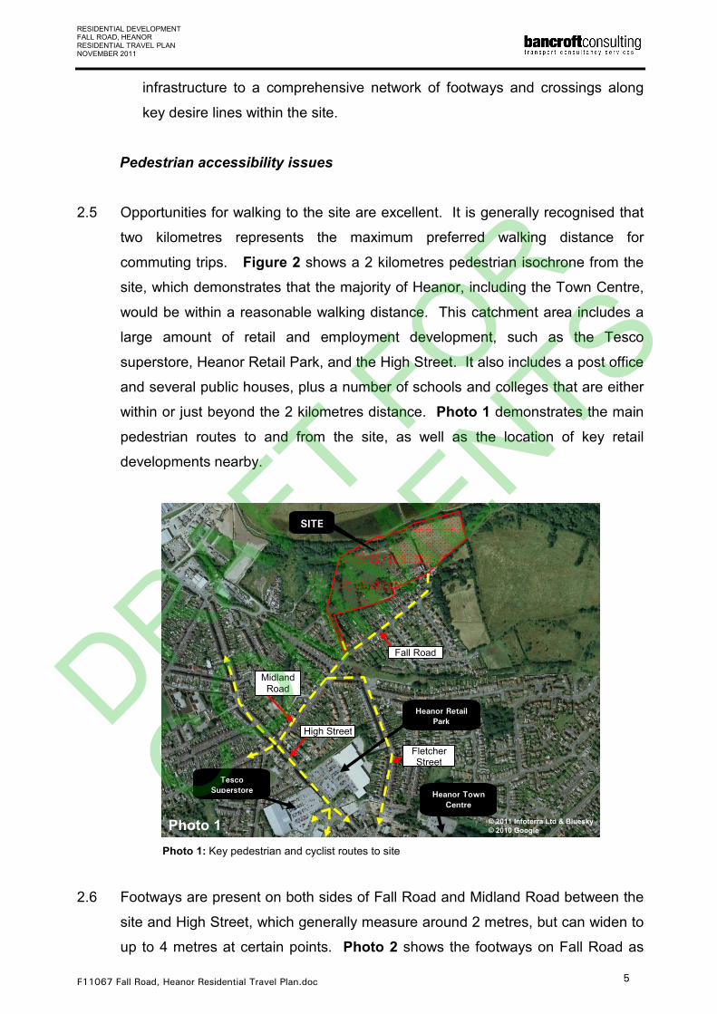
within or just beyond the 2 kilometres distance. Photo 1 demonstrates the main
pedestrian routes to and from the site, as well as the location of key retail
developments nearby.
Photo 1: Key pedestrian and cyclist routes to site
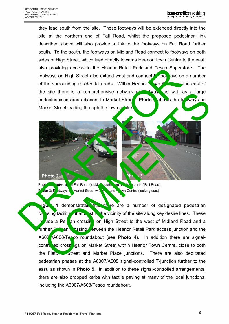
2.6 Footways are present on both sides of Fall Road and Midland Road between the
site and High Street, which generally measure around 2 metres, but can widen to
up to 4 metres at certain points. Photo 2 shows the footways on Fall Road as
SITE
Tesco
Superstore
Photo 1
Heanor Retail
Park
Heanor Town
Centre
Fall Road
Fletcher Street
High Street
Midland Road
© 2011 Infoterra Ltd & Bluesky
© 2010 Google
DRAFT FOR
COMMENTS
RESIDENTIAL DEVELOPMENT FALL ROAD, HEANOR RESIDENTIAL TRAVEL PLAN NOVEMBER 2011
F11067 Fall Road, Heanor Residential Travel Plan.doc 6
they lead south from the site. These footways will be extended directly into the
site at the northern end of Fall Road, whilst the proposed pedestrian link
described above will also provide a link to the footways on Fall Road further
south. To the south, the footways on Midland Road connect to footways on both
sides of High Street, which lead directly towards Heanor Town Centre to the east,
also providing access to the Heanor Retail Park and Tesco Superstore. The
footways on High Street also extend west and connect to footways on a number
of the surrounding residential roads. Within Heanor Town Centre to the east of
the site there is a comprehensive network of footways as well as a large
pedestrianised area adjacent to Market Street. Photo 3 shows the footways on
Market Street leading through the town centre.
Photo 2: Footways on Fall Road (looking south from northern end of Fall Road)
Photo 3: Footways on Market Street within Heanor Town Centre (looking east)
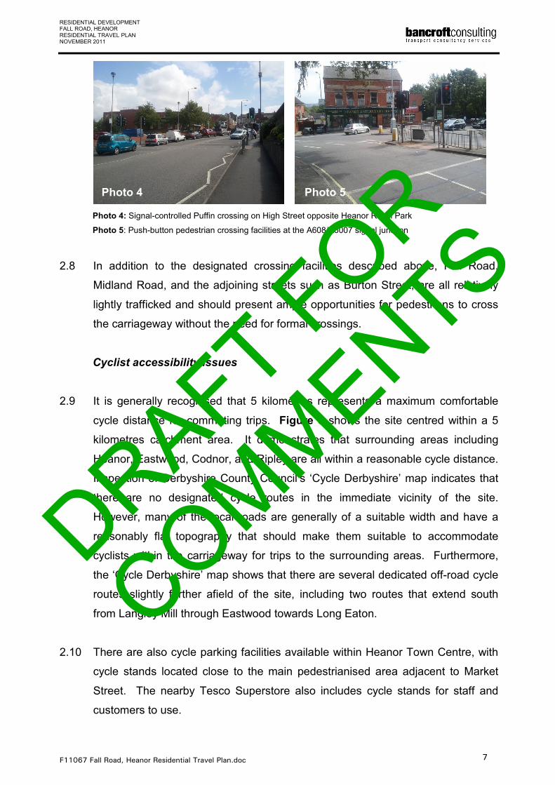
2.7 Figure 1 demonstrates that there are a number of designated pedestrian
crossing facilities that exist in the vicinity of the site along key desire lines. These
include a Pelican crossing on High Street to the west of Midland Road and a
further Pelican crossing between the Heanor Retail Park access junction and the
A6007/A608/Tesco roundabout (see Photo 4). In addition there are signal-
controlled crossings on Market Street within Heanor Town Centre, close to both
the Fletcher Street and Market Place junctions. There are also dedicated
pedestrian phases at the A6007/A608 signal-controlled T-junction further to the
east, as shown in Photo 5. In addition to these signal-controlled arrangements,
there are also dropped kerbs with tactile paving at many of the local junctions,
including the A6007/A608/Tesco roundabout.
Photo 2 Photo 3
DRAFT FOR
COMMENTS
RESIDENTIAL DEVELOPMENT FALL ROAD, HEANOR RESIDENTIAL TRAVEL PLAN NOVEMBER 2011
F11067 Fall Road, Heanor Residential Travel Plan.doc 7
Photo 4: Signal-controlled Puffin crossing on High Street opposite Heanor Retail Park
Photo 5: Push-button pedestrian crossing facilities at the A608/A6007 signal junction
2.8 In addition to the designated crossing facilities described above, Fall Road,
Midland Road, and the adjoining streets such as Burton Street, are all relatively
lightly trafficked and should present ample opportunities for pedestrians to cross
the carriageway without the need for formal crossings.
Cyclist accessibility issues
2.9 It is generally recognised that 5 kilometres represents a maximum comfortable
cycle distance for commuting trips. Figure 3 shows the site centred within a 5
kilometres catchment area. It demonstrates that surrounding areas including
Heanor, Eastwood, Codnor, and Ripley are all within a reasonable cycle distance.
Inspection of Derbyshire County Council’s ‘Cycle Derbyshire’ map indicates that
there are no designated cycle routes in the immediate vicinity of the site.
However, many of the local roads are generally of a suitable width and have a
reasonably flat topography that should make them suitable to accommodate
cyclists within the carriageway for trips to the surrounding areas. Furthermore,
the ‘Cycle Derbyshire’ map shows that there are several dedicated off-road cycle
routes slightly further afield of the site, including two routes that extend south
from Langley Mill through Eastwood towards Long Eaton.
2.10 There are also cycle parking facilities available within Heanor Town Centre, with
cycle stands located close to the main pedestrianised area adjacent to Market
Street. The nearby Tesco Superstore also includes cycle stands for staff and
customers to use.
Photo 4 Photo 5
DRAFT FOR
COMMENTS
RESIDENTIAL DEVELOPMENT FALL ROAD, HEANOR RESIDENTIAL TRAVEL PLAN NOVEMBER 2011
F11067 Fall Road, Heanor Residential Travel Plan.doc 8
Public transport accessibility issues
2.11 Details of local bus services can be obtained from a number of sources, including
Derbyshire County Council’s website, the local bus operators’ websites, and the
Traveline website. Alternatively, printed leaflets are available from either the local
bus operators or Derbyshire County Council. Figure 4 shows the existing bus
routes that operate within 400 metres of the site, along with the locations of
existing bus stop facilities that serve them. The frequency of each local bus route
is also summarised in Table 1.
2.12 Figure 4 shows that the closest stops are located immediately to the west of the
A6007/Midland Road junction, within 400 metres of the western site boundary.
These stops comprise a shelter at the northern edge of the carriageway and a
flag and pole type stop at the southern edge, serving a total of five bus routes that
travel to a number of the surrounding areas, including Ripley, Eastwood,
Nottingham, Derby, and Belper. There are also several bus stops slightly further
afield, including ones adjacent to the Heanor Retail Park and Tesco Superstore to
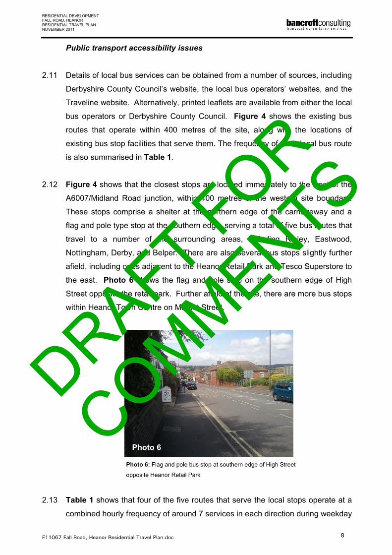
the east. Photo 6 shows the flag and pole stop on the southern edge of High
Street opposite the retail park. Further afield of the site, there are more bus stops
within Heanor Town Centre on Market Street.
Photo 6: Flag and pole bus stop at southern edge of High Street
opposite Heanor Retail Park
2.13 Table 1 shows that four of the five routes that serve the local stops operate at a
combined hourly frequency of around 7 services in each direction during weekday
Photo 6
DRAFT FOR
COMMENTS
RESIDENTIAL DEVELOPMENT FALL ROAD, HEANOR RESIDENTIAL TRAVEL PLAN NOVEMBER 2011
F11067 Fall Road, Heanor Residential Travel Plan.doc 9
peak periods, or an average of one service every 8.5 minutes. The other route,
number D1, only provides 1 service in each direction on Mondays. On
Saturdays, these routes operate at a frequency of approximately 5 to 6 services
in each direction per hour, with 3 services per hour in each direction on Sundays.
2.14 Detailed inspection of the timetables for these routes indicates that there are a
number of services that could link the proposed development to the main
employment areas further afield of the site, such as Nottingham, which would
arrive and depart in line with typical 0800 to 1800 hours working and school
times. For example, the Rainbow 1 route provides a service that departs at 0735
hours, which would allow people living within the proposed development to arrive
at Nottingham Victoria Bus Station by 0830 hours to start work at 0900 hours.
Similarly, the H1 provides a service that departs at 0820 hours and arrives in
Derby City Centre at 0852 hours for a 0900 hours start.
2.15 Trent Barton operate three of the local bus routes that run within 400 metres of
the site and offer a variety of ticket types. Aside from the standard single and
return type tickets, they offer a range of multiple travel tickets. These include the
‘Zigzag’ all day ticket after 0900 hours, the ‘Zigzag plus’ all day ticket for any time
of the day, and the ‘Zigzag group’ for up to 5 people travelling after 0900 hours.
The current prices for these tickets are as follows:
• Zigzag: £4.90 per day
• Zigzag plus: £10.00 per day
• Zigzag group: £12.00 per day
Trent Barton also offer a Mango travel card, which can be topped up online and
provides a saving of 25% off the single cash fare on every journey made. Further
details regarding the price of tickets and how to purchase them can be found at
www.trentbarton.co.uk. Ticket price details for the other operators can be found
on their websites at http://www.brightsites.org.uk/yourbus and
www.centrebus.info.
Car accessibility issues
2.16 Vehicular access to the site will be provided via an extension of Fall Road at its
northern end. Fall Road leads directly into Midland Road to the south, which
DRAFT FOR
COMMENTS
RESIDENTIAL DEVELOPMENT FALL ROAD, HEANOR RESIDENTIAL TRAVEL PLAN NOVEMBER 2011
F11067 Fall Road, Heanor Residential Travel Plan.doc 10
subsequently connects to High Street (A6007). To the north-west, the A6007
leads to the A610 towards Ripley and the A38. To the east, it leads past the
Tesco Superstore and Heanor Retail Park into Heanor Town Centre. Further
afield, the A6007 leads to the A609 and A610, which connect to the M1
Motorway, whilst the A6007 also leads south into Ilkeston. The
A6007/A608/Tesco roundabout experiences significant queues during peak
periods, however traffic associated with the south can avoid this roundabout by
traveling via Fletcher Street, which links Fall Road with Market Street.
DRAFT FOR
COMMENTS
RESIDENTIAL DEVELOPMENT FALL ROAD, HEANOR RESIDENTIAL TRAVEL PLAN NOVEMBER 2011
F11067 Fall Road, Heanor Residential Travel Plan.doc 11
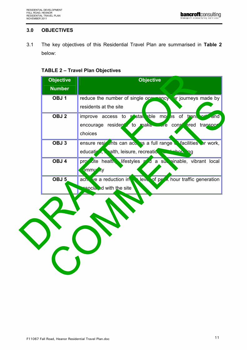
3.0 OBJECTIVES
3.1 The key objectives of this Residential Travel Plan are summarised in Table 2
below:
TABLE 2 – Travel Plan Objectives
Objective
Number
Objective
OBJ 1 reduce the number of single occupancy car journeys made by
residents at the site
OBJ 2 improve access to sustainable modes of transport and
encourage residents to make more considered transport
choices
OBJ 3 ensure residents can access a full range of facilities for work,
education, health, leisure, recreation, and shopping
OBJ 4 promote healthy lifestyles and a sustainable, vibrant local
community
OBJ 5 achieve a reduction in the level of peak hour traffic generation
associated with the site
DRAFT FOR
COMMENTS
RESIDENTIAL DEVELOPMENT FALL ROAD, HEANOR RESIDENTIAL TRAVEL PLAN NOVEMBER 2011
F11067 Fall Road, Heanor Residential Travel Plan.doc 12
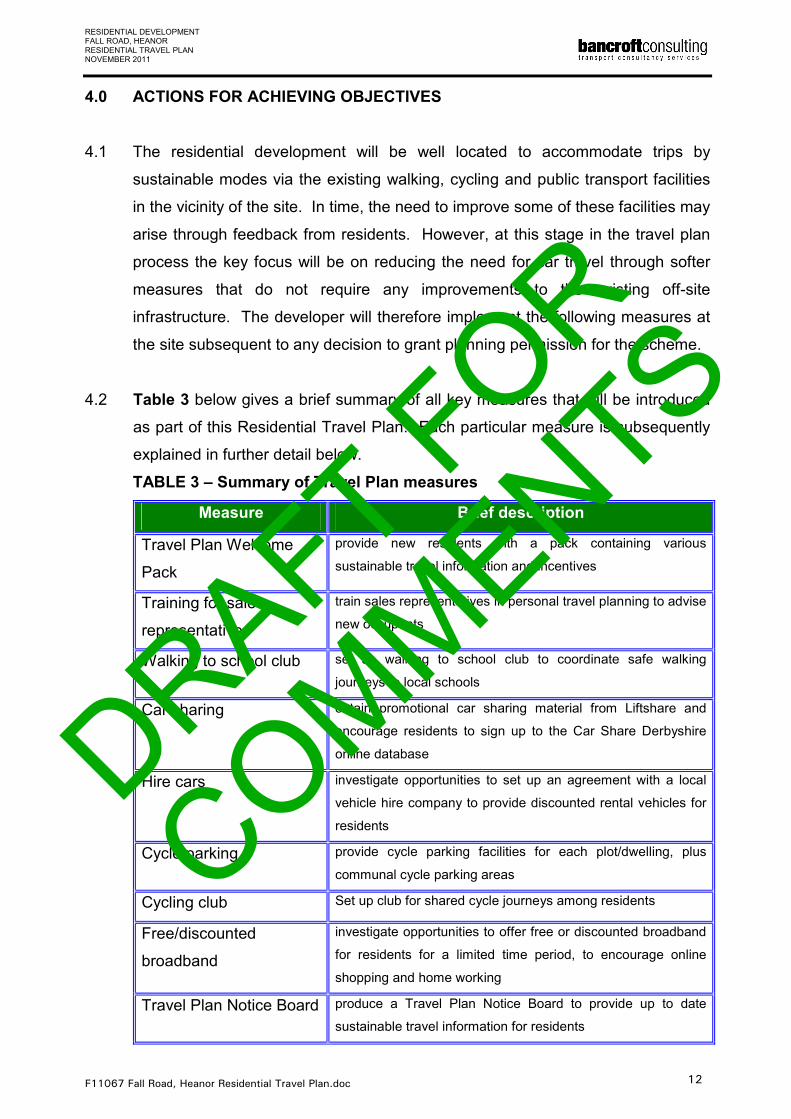
4.0 ACTIONS FOR ACHIEVING OBJECTIVES
4.1 The residential development will be well located to accommodate trips by
sustainable modes via the existing walking, cycling and public transport facilities
in the vicinity of the site. In time, the need to improve some of these facilities may
arise through feedback from residents. However, at this stage in the travel plan
process the key focus will be on reducing the need for car travel through softer
measures that do not require any improvements to the existing off-site
infrastructure. The developer will therefore implement the following measures at
the site subsequent to any decision to grant planning permission for the scheme.
4.2 Table 3 below gives a brief summary of all key measures that will be introduced
as part of this Residential Travel Plan. Each particular measure is subsequently
explained in further detail below.
TABLE 3 – Summary of Travel Plan measures
Measure Brief description
Travel Plan Welcome
Pack
provide new residents with a pack containing various
sustainable travel information and incentives
Training for sale
representatives
train sales representatives in personal travel planning to advise
new occupants
Walking to school club set up walking to school club to coordinate safe walking
journeys to local schools
Car sharing obtain promotional car sharing material from Liftshare and
encourage residents to sign up to the Car Share Derbyshire
online database
Hire cars investigate opportunities to set up an agreement with a local
vehicle hire company to provide discounted rental vehicles for
residents
Cycle parking provide cycle parking facilities for each plot/dwelling, plus
communal cycle parking areas
Cycling club Set up club for shared cycle journeys among residents
Free/discounted
broadband
investigate opportunities to offer free or discounted broadband
for residents for a limited time period, to encourage online
shopping and home working
Travel Plan Notice Board produce a Travel Plan Notice Board to provide up to date
sustainable travel information for residents
DRAFT FOR
COMMENTS

RESIDENTIAL DEVELOPMENT FALL ROAD, HEANOR RESIDENTIAL TRAVEL PLAN NOVEMBER 2011
F11067 Fall Road, Heanor Residential Travel Plan.doc 13
4.3 The developer will issue a Travel Plan Welcome Pack to new residents when
they receive the keys to their property. This pack will comprise up to date
sustainable transport information and several incentives to influence travel habits,
including the following:
• Details of all bus routes that operate in the vicinity of the site, along with
maps showing local walking and cycle routes and details of any forthcoming
promotional events in the local area for sustainable travel.
• A map showing the locations of local amenities that are easily accessible by
walking, cycling, and public transport, such as local schools, shops, and post
offices.
• Information on cycling safety.
• The choice of either a voucher for £50 to cover the purchase of cycling
equipment at a local store, such as Mick Brown Cycles in Eastwood, or a
pass for a months free travel on Trent Barton bus services (subject to
negotiations with the operator).
• An initial feedback survey to gather early information about perceived
transport choices (see ‘Targets and Monitoring’ section below for further
details).
• A copy of this Travel Plan and contact details for relevant organisations, such
as Derbyshire County Council’s Public Transport Department and local taxi
companies.
4.4 As part of the normal process of handing over properties to new residents, sales
representatives will be trained in personalised travel planning so that they can
provide travel advice. This will enhance residents’ awareness of the Travel Plan
and also highlight the sustainable travel opportunities that are available to them.
In addition, the developer will market the properties in such a way that future
residents are aware of the surrounding opportunities to travel by sustainable
modes.
4.5 The developer shall liaise with the local schools to set up a ‘walking to school
club’ which will be made available to all residents within the site. This will
encourage parents and children to walk to the nearby schools within the
surrounding area. A system will be set up between the local schools and
residents, where participants arrange to meet up before and after school and
DRAFT FOR
COMMENTS

RESIDENTIAL DEVELOPMENT FALL ROAD, HEANOR RESIDENTIAL TRAVEL PLAN NOVEMBER 2011
F11067 Fall Road, Heanor Residential Travel Plan.doc 14
coordinate walking journeys. Participants of the scheme will be given
promotional high visibility vests and umbrellas. As part of the process of setting
up this club, the developer will liaise with representatives of the local schools and
Amber Valley Borough Council to establish whether there are any existing
schemes such as this in Heanor that could be linked with this site-specific club.
Furthermore, the developer will liaise with the local schools to explore possibilities
for future joint measures to encourage sustainable travel between the dwellings
and surrounding schools.
4.6 The developer will liaise with the organisation ‘Liftshare’ (www.liftshare.com) to
obtain promotional material for the ‘Car Share Derbyshire’ online car sharing
database (www.carsharederbyshire.com). The ‘Car Share Derbyshire’ database
contains details of the planned car journeys of its users across the county,
allowing other users to identify opportunities to car share with other people within
the Derbyshire area. All residents who drive will be encouraged to register for
free on the database, with details on how to do so being included within the
Travel Plan Welcome Pack. Each resident that signs up to the database will be
given login details with which they can access the journey details of other users.
Residents will have the benefit of being able to access the car share database to
identify any opportunities to car share with people from within the development
and also the rest of Heanor and the surrounding areas.
4.7 In addition to signing up to a car share scheme, the developer will also liaise with
local car hire companies to investigate the possibility of providing discounted
rates for car hire. This could help residents avoid having to buy a car that they
would use only for occasional journeys and when travel by sustainable modes is
not possible. Anyday Car Hire is located close to the site within the Heanor Gate
Industrial Estate and could offer a convenient opportunity to set up such a
scheme.
4.8 To encourage cycling, the developer will investigate the possibility of including
cycle parking facilities within each individual plot/dwelling. These could
potentially comprise a single Sheffield Stand within each property boundary, or a
wall-mounted cycle rack within the garages of certain properties. In addition, the
developer will consider including some communal cycle parking areas within the
DRAFT FOR
COMMENTS

RESIDENTIAL DEVELOPMENT FALL ROAD, HEANOR RESIDENTIAL TRAVEL PLAN NOVEMBER 2011
F11067 Fall Road, Heanor Residential Travel Plan.doc 15
site should a significant level of demand among residents be identified. It is
recommended that two or three cycle shelters at convenient locations within the
site, each comprising two Sheffield Stands, should be sufficient for any communal
areas that are provided. Future travel surveys conducted at the site will help to
identify whether any off-site improvements may be required to accommodate
cycle trips, such as additional designated cycle routes linking the development
with the local schools and employment areas.
4.9 The developer will also set up a Cycling Club at the site, which residents could
sign up to share/coordinate cycling journeys within the surrounding areas. This
could include shared trips to work, or leisure cycling trips. It could also be linked
with the ‘walking to school club’ to encourage children to cycle to school. As an
alternative, residents could be encouraged to sign-up for free to the national
BikeBUDi database (www.bikebudi.liftshare.com), which is run by the Liftshare
organisation. This database allows users to register their work or leisure based
cycle journeys online to help identify opportunities to ride together with other
cyclists.
4.10 The developer will investigate the possibility of providing new residents with a
free or discounted broadband connection for a limited period, say three months,
to encourage home working and online shopping. This could help to reduce the
need for residents to travel by car.
4.11 To further market the surrounding opportunities for travel by non-car modes,
Travel Plan Notice Boards will be located at convenient points within the site
where they will be visible to all residents, such as in open communal areas.
These boards will be kept up to date by the developer to include the latest
sustainable travel information such as bus timetables, details of local taxi
companies, and local walking and cycling maps. The developer will also include
details on their website in respect of opportunities to access the site and
surrounding amenities by sustainable modes. Once the development is 75%
occupied, the developer will also organise an event at the site to promote
sustainable travel, which could include free cycle training or a ‘non-car travel’ day.
DRAFT FOR
COMMENTS
RESIDENTIAL DEVELOPMENT FALL ROAD, HEANOR RESIDENTIAL TRAVEL PLAN NOVEMBER 2011
F11067 Fall Road, Heanor Residential Travel Plan.doc 16
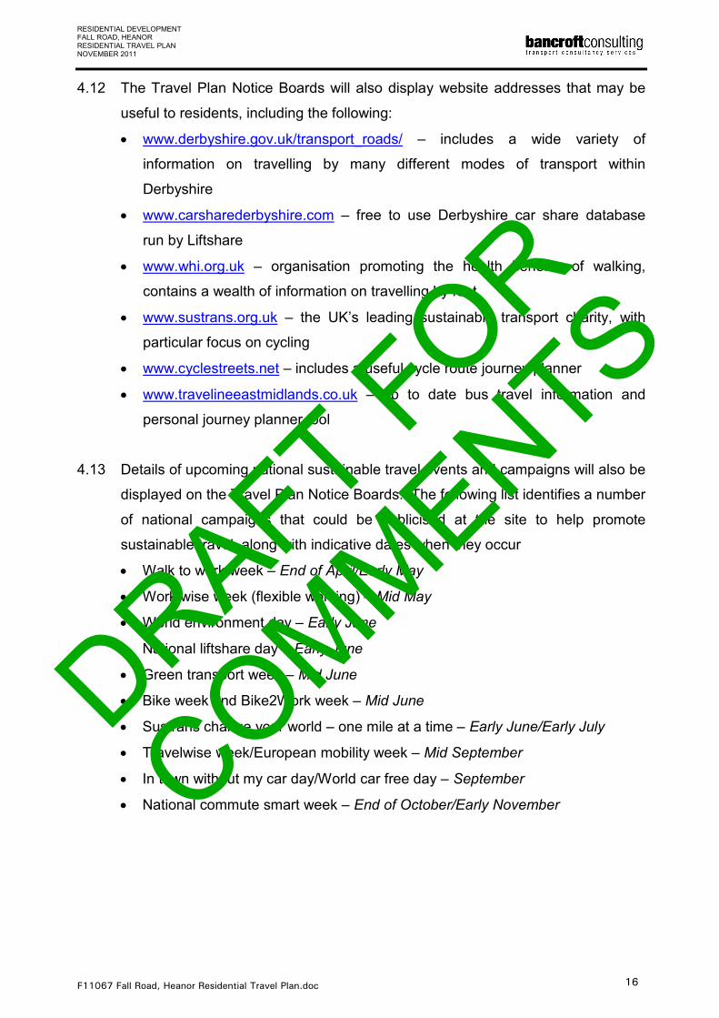
4.12 The Travel Plan Notice Boards will also display website addresses that may be
useful to residents, including the following:
• www.derbyshire.gov.uk/transport_roads/ – includes a wide variety of
information on travelling by many different modes of transport within
Derbyshire
• www.carsharederbyshire.com – free to use Derbyshire car share database
run by Liftshare
• www.whi.org.uk – organisation promoting the health benefits of walking,
contains a wealth of information on travelling by foot
• www.sustrans.org.uk – the UK’s leading sustainable transport charity, with
particular focus on cycling
• www.cyclestreets.net – includes a useful cycle route journey planner
• www.travelineeastmidlands.co.uk – up to date bus travel information and
personal journey planner tool
4.13 Details of upcoming national sustainable travel events and campaigns will also be
displayed on the Travel Plan Notice Boards. The following list identifies a number
of national campaigns that could be publicised at the site to help promote
sustainable travel, along with indicative dates when they occur
• Walk to work week – End of April/Early May
• Work wise week (flexible working) – Mid May
• World environment day – Early June
• National liftshare day – Early June
• Green transport week – Mid June
• Bike week and Bike2Work week – Mid June
• Sustrans change your world – one mile at a time – Early June/Early July
• Travelwise week/European mobility week – Mid September
• In town without my car day/World car free day – September
• National commute smart week – End of October/Early November
DRAFT FOR
COMMENTS
RESIDENTIAL DEVELOPMENT FALL ROAD, HEANOR RESIDENTIAL TRAVEL PLAN NOVEMBER 2011
F11067 Fall Road, Heanor Residential Travel Plan.doc 17
5.0 TARGETS AND MONITORING
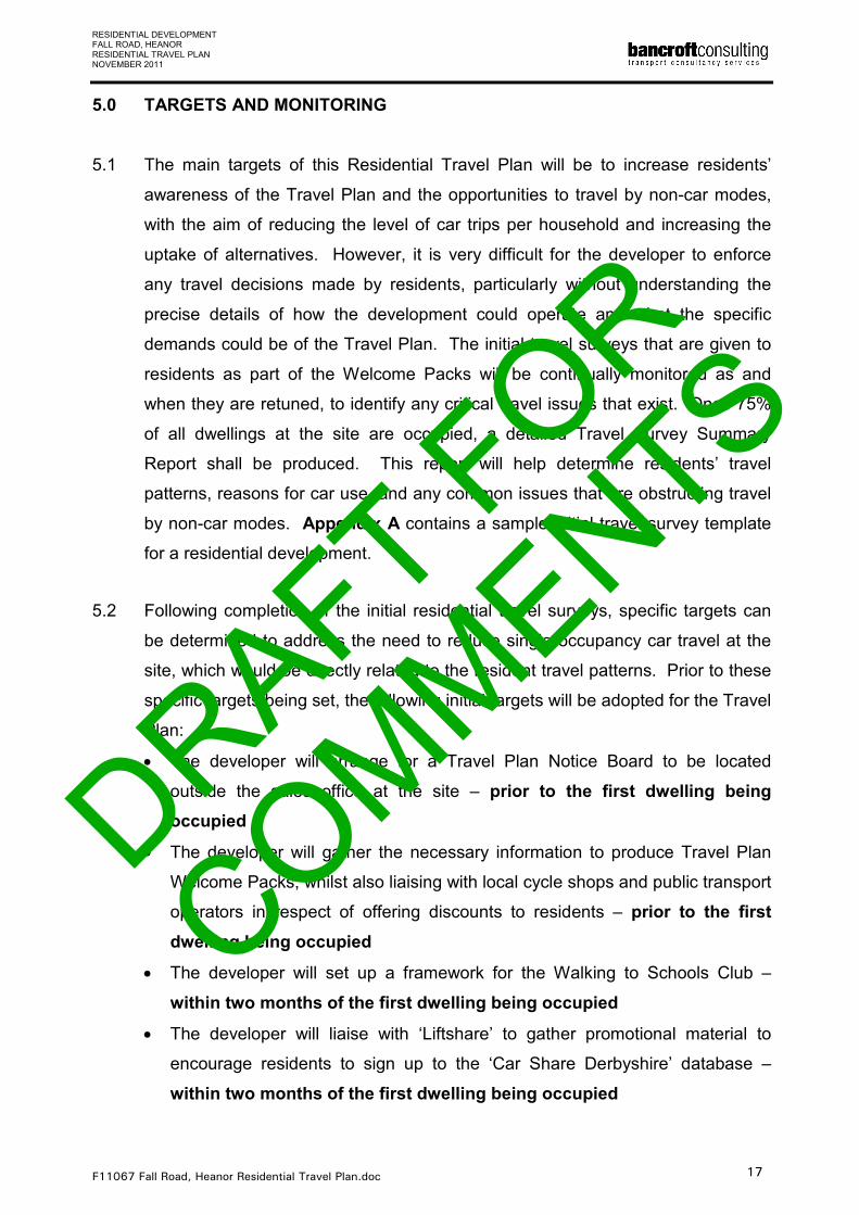
5.1 The main targets of this Residential Travel Plan will be to increase residents’
awareness of the Travel Plan and the opportunities to travel by non-car modes,
with the aim of reducing the level of car trips per household and increasing the
uptake of alternatives. However, it is very difficult for the developer to enforce
any travel decisions made by residents, particularly without understanding the
precise details of how the development could operate and what the specific
demands could be of the Travel Plan. The initial travel surveys that are given to
residents as part of the Welcome Packs will be continually monitored as and
when they are retuned, to identify any critical travel issues that exist. Once 75%
of all dwellings at the site are occupied, a detailed Travel Survey Summary
Report shall be produced. This report will help determine residents’ travel
patterns, reasons for car use, and any common issues that are obstructing travel
by non-car modes. Appendix A contains a sample initial travel survey template
for a residential development.
5.2 Following completion of the initial residential travel surveys, specific targets can
be determined to address the need to reduce single occupancy car travel at the
site, which would be directly related to the resident travel patterns. Prior to these
specific targets being set, the following initial targets will be adopted for the Travel
Plan:
• The developer will arrange for a Travel Plan Notice Board to be located
outside the sales office at the site – prior to the first dwelling being
occupied
• The developer will gather the necessary information to produce Travel Plan
Welcome Packs, whilst also liaising with local cycle shops and public transport
operators in respect of offering discounts to residents – prior to the first
dwelling being occupied
• The developer will set up a framework for the Walking to Schools Club –
within two months of the first dwelling being occupied
• The developer will liaise with ‘Liftshare’ to gather promotional material to
encourage residents to sign up to the ‘Car Share Derbyshire’ database –
within two months of the first dwelling being occupied
DRAFT FOR
COMMENTS
RESIDENTIAL DEVELOPMENT FALL ROAD, HEANOR RESIDENTIAL TRAVEL PLAN NOVEMBER 2011
F11067 Fall Road, Heanor Residential Travel Plan.doc 18
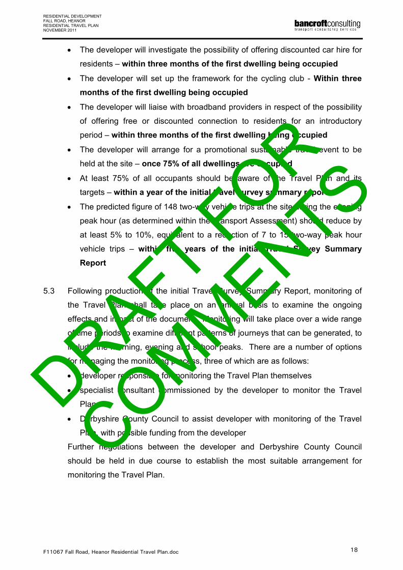
• The developer will investigate the possibility of offering discounted car hire for
residents – within three months of the first dwelling being occupied
• The developer will set up the framework for the cycling club - Within three
months of the first dwelling being occupied
• The developer will liaise with broadband providers in respect of the possibility
of offering free or discounted connection to residents for an introductory
period – within three months of the first dwelling being occupied
• The developer will arrange for a promotional sustainable travel event to be
held at the site – once 75% of all dwellings are occupied
• At least 75% of all occupants should be aware of the Travel Plan and its
targets – within a year of the initial travel survey summary report
• The predicted figure of 148 two-way vehicle trips at the site during the evening
peak hour (as determined within the Transport Assessment) should reduce by
at least 5% to 10%, equivalent to a reduction of 7 to 15 two-way peak hour
vehicle trips – within five years of the initial Travel Survey Summary
Report
5.3 Following production of the initial Travel Survey Summary Report, monitoring of
the Travel Plan shall take place on an annual basis to examine the ongoing
effects and impact of the document. Monitoring will take place over a wide range
of time periods to examine different patterns of journeys that can be generated, to
include the morning, evening and school peaks. There are a number of options
for managing the monitoring process, three of which are as follows:
• developer responsible for monitoring the Travel Plan themselves
• specialist consultant commissioned by the developer to monitor the Travel
Plan
• Derbyshire County Council to assist developer with monitoring of the Travel
Plan, with possible funding from the developer
Further negotiations between the developer and Derbyshire County Council
should be held in due course to establish the most suitable arrangement for
monitoring the Travel Plan.
DRAFT FOR
COMMENTS
RESIDENTIAL DEVELOPMENT FALL ROAD, HEANOR RESIDENTIAL TRAVEL PLAN NOVEMBER 2011
F11067 Fall Road, Heanor Residential Travel Plan.doc 19
5.4 The contact details for Derbyshire County Council’s Travel Plan Officer are as
follows:
Richard Lovell
Sustainable Travel Officer
Sustainable Travel Team
Derbyshire County Council
County Hall, Matlock
Derbyshire
DE4 3AG
tel: 01629 538192
email: [email protected]
DRAFT FOR
COMMENTS

Belper-Kilburn-Heanor-Langley 1 service 120 mins 120 mins
Nottingham-Eastwood-Heanor-Ripley 30 mins 30 mins 30 mins
60 mins No service
NOTE: Service D1 runs Mondays only (except Bank holidays)
No service
2 services
No service
TABLE 1: DETAILS OF LOCAL BUS SERVICES
DetailsOperator
off peakPM peak
(1600-1800)Saturday Sunday
1 Trent Barton
Route No.
No service
Ripley-Heanor-Eastwood-Nottingham 20 mins 4/hour 30 mins 30 mins
Weekdays
Frequency (services)
AM peak
(0730-0930)
30 mins
3/hour 30 mins
1a Trent Barton
Ripley-Heanor-Langley-Aldercar 2 services 2 services No service
Aldercar-Langley-Heanor-Ripley 3 services 2 services 60 mins No service No service
No service
138 Yourbus
Langley-Heanor-Kilburn-Belper 3 services 1 service 120 mins 120 mins No service
D1 Veolia
Nottingham-Heanor-Matlock-Bakewell No service 1 service No service
Bakewell-Matlock-Heanor-Nottingham
60 mins
H1
Alfreton - Heanor - Derby 20 mins
No service 1 service No service No service
Trent Barton
60 mins
Derby - Heanor - Alfreton
20 mins 20 mins 20 mins
20 mins 20 mins 20 mins 20 mins
DRAFT FOR
COMMENTS
XXXX FALL ROAD, HEANOR
AG
21/10/11
Do Not Scale
DATE:
DRAWN:
CLIENT: JOB TITLE:
JOB NUMBER: FIGURE:
1SITE LOCATION AND NEARBY PEDESTRIAN CROSSING FACILITIESTITLE:
Do Not ScaleSCALE:
F11067
N
©Crown copyright. All rights reserved.
OS Licence number 100044404
SITE
MR S CRESSWELL
KEY
Signal-controlled crossing
Zebra crossing DRAFT FOR
COMMENTS

XXXX FALL ROAD, HEANOR
AG
21/10/11
Do Not Scale
DATE:
DRAWN:
CLIENT: JOB TITLE:
JOB NUMBER: FIGURE:
2PEDESTRIAN ISOCHRONE (2 KILOMETRES)TITLE:
Do Not ScaleSCALE:
F11067
©Crown copyright. All rights reserved.
OS Licence number 100044404
N
©Crown copyright. All rights reserved.
OS Licence number 100044404
MR S CRESSWELL
SITE
DRAFT FOR
COMMENTS

XXXX FALL ROAD, HEANOR
AG
21/10/11
Do Not Scale
DATE:
DRAWN:
CLIENT: JOB TITLE:
JOB NUMBER: FIGURE:
3CYCLIST CATCHMENT AREA (5 KILOMETRES)TITLE:
Do Not ScaleSCALE:
F11067
©Crown copyright. All rights reserved.
OS Licence number 100044404
N
©Crown copyright. All rights reserved.
OS Licence number 100044404
SITE
MR S CRESSWELL
DRAFT FOR
COMMENTS

XXXX FALL ROAD, HEANOR
AG
21/10/11
Do Not Scale
DATE:
DRAWN:
CLIENT: JOB TITLE:
JOB NUMBER: FIGURE:
4LOCAL BUS ROUTES
TITLE:
Do Not ScaleSCALE:
F11067
N
SITE
400
metres
MR S CRESSWELL
©Crown copyright. All rights reserved.
OS Licence number 100044404
KEY
Route 1
Route 1a
Route 138
Route D1
Route H1
Bus stop DRAFT FOR
COMMENTS

APPENDIX A – SAMPLE RESIDENTIAL TRAVEL SURVEY
DRAFT FOR
COMMENTS

Residential Travel Survey
Please could the head of the household take a moment to answer the following questions regarding how you travel to and from your home.
Please complete in BLOCK CAPITALS using Black / Blue ink. 1. How many people live in your household? 1 2 3+ 2. Roughly how often do you travel by the following means of transport?:
Method of Travel Daily
A few times per
week
Once a week
Once every two
weeks
Once a month Rarely Never
By foot
Cycling
Bus
Train Car (on
own)
Car (with others)
Taxi
Other 3. What is your most common reason for travelling? Work Shopping Leisure School Run Other (please specify) 4. How many cars do you own as a household? 1 2 3+ Thank you for taking the time to fill in this survey, please could you provide your name and address number below:
Name:
Address:
DRAFT FOR
COMMENTS