mountain view small area plan - catawba county€¦ · mountain view small area plan 6 introduction...
TRANSCRIPT
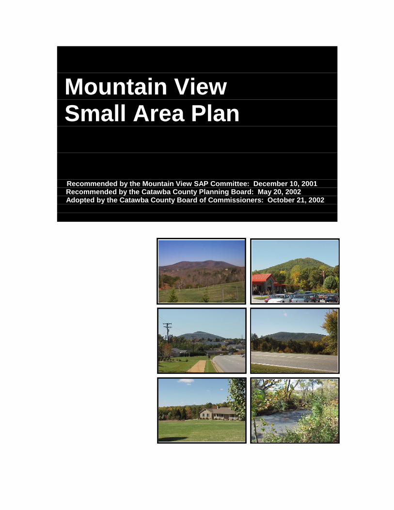
Mountain View Small Area Plan Recommended by the Mountain View SAP Committee: December 10, 2001 Recommended by the Catawba County Planning Board: May 20, 2002 Adopted by the Catawba County Board of Commissioners: October 21, 2002

Mountain View Small Area Plan
2
PLAN PARTICIPANTS
CATAWBA COUNTY BOARD OF COMMISSIONERS W. Steve Ikerd, Chair
Marie H. Huffman, Vice Chair Kitty W. Barnes
Barbara G. Beatty Dan A. Hunsucker
MOUNTAIN VIEW SMALL AREA PLAN COMMITTEE Debbie Pitts, Chair
Steve Von Drehle, Planning Board Liaison Paul Fleetwood Larry Johnson
Jeanette Ringley Wade Scronce
Carroll Lackey, Former Member Donald McSwain, Former Member
CATAWBA COUNTY PLANNING BOARD Ray Von Caldwell, Chair
Michael C. Miller, Vice Chair Anne B. Barrier
Paul A. Beatty, Jr. Charles F. Connor, III
Edward C. Neill Steve Von Drehle
Sam Wright William “Rusty” Lutz
CATAWBA COUNTY PLANNING STAFF Jacky M. Eubanks, Director of Planning & Community Development
Mary K. George, County Planner Rich A. Hoffman, Planner
OTHER PARTICIPANTS, SPECIAL THANKS Tom Carr, Executive Assistant for Development, City of Hickory
Chuck Hansen, Hickory Public Service Director
Technical Assistance Provided By: Western Piedmont Council of Governments

Mountain View Small Area Plan
3
(PAGE LEFT BLANK INTENTIONALLY)

Mountain View Small Area Plan
4
PLAN CONTENTS INTRODUCTION .................................................................................................. 6
BACKGROUND ................................................................................................. 6 Purpose ......................................................................................................... 6 Process .......................................................................................................... 6
STUDY AREA ................................................................................................... 8 HISTORICAL CONTEXT .................................................................................. 8 COMMUNITY PROFILE ....................................................................................... 9
ASSETS AND KEY ISSUES ............................................................................. 9 Community Assets ......................................................................................... 9 Key Issues ..................................................................................................... 9
MAJOR POINTS OF REFERENCE ................................................................ 10 DEMOGRAPHIC PROFILE ............................................................................. 10
DEMOGRAHIC PROJECTION ………………………………………………….. 13 LAND USE AND COMMUNITY DESIGN ........................................................... 15
CURRENT CONDITIONS AND TRENDS ....................................................... 15 Current Land Use ........................................................................................ 15 Land Use Distribution .................................................................................. 16
Site Development Patterns and Land Design Trends .................................. 17 GUIDING PRINCIPLES ................................................................................... 18 PLAN RECOMMENDATIONS ......................................................................... 19
TRANSPORTATION .......................................................................................... 23 CURRENT CONDITIONS AND TRENDS ....................................................... 23
Roads & Highways ...................................................................................... 23 Pedestrian System ....................................................................................... 24 Bicycle System ............................................................................................ 24 Transit System ............................................................................................. 24 Passenger Rail ............................................................................................ 25
GUIDING PRINCIPLES ................................................................................... 26 PLAN RECOMMENDATIONS ......................................................................... 27
COMMUNITY FACILITIES AND PUBLIC SERVICES ....................................... 30 CURRENT CONDITIONS AND TRENDS ....................................................... 30
Schools ........................................................................................................ 30 Mountain View Elementary School ........................................................... 30 Blackburn Elementary School .................................................................. 30 Jacobs Fork Middle and Fred T. Foard High Schools .............................. 31
Parks and Greenways ................................................................................. 32 Libraries ....................................................................................................... 32 Water Service .............................................................................................. 32 Sewer Service .............................................................................................. 33 Emergency Services .................................................................................... 33
Police ....................................................................................................... 33 Fire ........................................................................................................... 33 EMS ......................................................................................................... 34

Mountain View Small Area Plan
5
GUIDING PRINCIPLES ................................................................................... 35 PLAN RECOMMENDATIONS ......................................................................... 36
HOUSING ........................................................................................................... 38 CURRENT CONDITIONS AND TRENDS ....................................................... 38 GUIDING PRINCIPLES ................................................................................... 39 PLAN RECOMMENDATIONS ......................................................................... 40
ECONOMIC DEVELOPMENT ............................................................................ 41 CURRENT CONDITIONS AND TRENDS ....................................................... 41 GUIDING PRINCIPLES ................................................................................... 42 PLAN RECOMMENDATIONS ......................................................................... 43
NATURAL RESOURCES ................................................................................... 44 CURRENT CONDITIONS AND TRENDS ....................................................... 44
Rivers .......................................................................................................... 44 Bakers Mountain .......................................................................................... 44
Open Space and Scenic Topography …………………………………………45 GUIDING PRINCIPLES ................................................................................... 46 PLAN RECOMMENDATIONS ......................................................................... 47
CULTURAL RESOURCES ................................................................................. 49 CURRENT CONDITIONS AND TRENDS ....................................................... 49 GUIDING PRINCIPLES ................................................................................... 50 PLAN RECOMMENDATIONS ......................................................................... 51
APPENDIX A ...................................................................................................... 52 COMMUNITY MEETING RESULTS ............................................................... 52 MAPS following page number: Map 1: MVSAP Boundary ............................................................................... . 9 Map 2: MVSAP Census Tracts ......................................................................... 11 Map 3: MVSAP Current Land Uses .................................................................. 15 Map 4: MVSAP Current Zoning......................................................................... 17 Map 5A MVSAP Proposed Density Districts ...................................................... 19 Map 6: MVSAP Future Landuse Recommendations ......................................... 21 Map 7: MVSAP Natural & Cultural Resources .................................................. 21 Map 8: MVSAP Current, Planned & Recommended Transportation System .... 29 Map 9: MVSAP Proposed Zoning Map Amendments ....................................... 39
Mountain View Small Area Plan
6
INTRODUCTION
BACKGROUND
Purpose The concept of conducting small area plans for Catawba County was one of sixteen growth strategies resulting from the County's long-range Strategic Growth Plan (1999). The Growth Plan stated that the Small Area Plans "would explore general development patterns and trends and evaluate public service/facility deficiencies needing attention." The document further stated that the plans should also "include conceptual sketch plans based upon appropriate land use and zoning concepts and be used for consideration for future zoning changes and subdivision standards." Through the development of the small area plan, a committee would assess their area's current quality of life and sustainability on issues such as traffic congestion, residential development patterns, water quality, library service levels, utility capacities and school facilities. Upon reviewing these issues, the committee then would recommend measures for improvement. Specifically, the Small Area Planning Committee was asked to discuss and develop goals and action statements for the following issues: 1) economic development; 2) natural resources; 3) cultural resources; 4) community facilities and public services; 5) housing; 6) land use and community design; and 7) transportation. The plan would then include implementation strategies for the goals and action statements, whether it is through ordinance or policy amendments, modified capital improvement plans, or coordination with other agencies to complete specific tasks.
Process The process for developing the small area plan was a grassroots effort that began with the appointment of the Mountain View Small Area Planning (MVSAP) Committee in January 2000 by the Board of Commissioners. Eight initial committee members were interested citizens who live or own land in the Small Area Plan boundary and volunteered their time to develop a small area plan for their community. The committee also consisted of a Planning Board member who served as liaison to the Board. The County Planning staff and the Western Piedmont Council of Governments educated and assisted the committee in the development of their individual plan. During the process of developing the plan, the committee solicited input from citizens in the planning area through a community input meeting held in June 2000. At this meeting, citizens were asked how they saw their community developing in the future using a 10 to 20 year planning period. One hundred seventy-nine (179) residents participated in this meeting held at the Mountain View Elementary School. Results from this community input meeting are provided in Appendix A. The committee used this

Mountain View Small Area Plan
7
input in the development of the plan’s guiding principles and recommendations. Upon completion of a draft plan, the committee sponsored another public meeting in November 2001, which also was held at the Mountain View Elementary School. At this meeting, the Plan’s maps and recommendations were presented to the community. Input from the 170 residents who participated at this meeting was considered by the committee in amending the draft plan. When the committee's recommendations were complete, their final document was presented to the Planning Board and Board of Commissioners for review and consideration for adoption. Presentation to these Boards was through a public hearing process, where the public was invited to express its comments on the proposed plan. The committee presented the final document to the Planning Board at its February 25, 2002 meeting. Upon hearing citizen comments regarding the plan, the Planning Board conducted two joint meetings with the committee to address the issues presented. The Planning Board subsequently recommended the plan at its May 20, 2002 meeting. The Board of Commissioners held a special work session on June 17, 2002 with the Planning Board to review the Plan. The Board of Commissioners then conducted a public hearing on August 19, 2002 and directed staff to develop options for consideration by the Board. A second public hearing was held on October 21, 2002 for the Board to consider amendments to the plan. The Board of Commissioners adopted the plan at its October 21, 2002 meeting. Over the next five years issues may arise that have not been addressed in this document. Since the plan is intended to be an active document, it must be capable of adapting to changes and new challenges. The MVSAP Committee recommends reviewing the plan every five years, or as conditions change. Amendments to the Plan have a potential impact on all residents and businesses in the Mountain View area and therefore should be treated in a manner that would allow for public input, through notice and hearings, during the amendment procedure. It should be noted that many residents attending the June 2000 community meeting voiced their opposition to annexation by the City of Hickory. General Statute 160A-36 grants authority to municipalities to annex if certain statutory standards can be met. The MVSAP committee discussed the annexation concerns voiced by residents; however, they realized that municipalities do have the authority to annex.
Mountain View Small Area Plan
8
STUDY AREA The Mountain View Small Area Plan (MVSAP) study area boundary follows the Burke/Catawba County border to the west; the unincorporated area outside of Long View, Brookford and Hickory to the north; Robinwood Road and Zion Church Road to the east; Sandy Ford Road between Robinwood and Zion Church Roads to the south; Highway 10 between Zion Church Road and Highway 127 to the south; Greedy Highway between Highway 127 and the Burke/Catawba County line to the south. The study area encompasses 20,035 acres. See Map 1, MVSAP Boundary
HISTORICAL CONTEXT The Jacob Fork community, located north of the confluence of the Jacob Fork and Henry Fork, was one of the earliest identifiable communities in what would become Catawba County and the closest establishment to present day Mountain View. Evidence indicates that Henry Weidner trapped in Catawba County as early as 1739. However, it wasn't until after 1748 that Weidner extended the Catawba Path west from Sherrills Ford, the earliest established community in present day Catawba County, along the ridge to Newton then south to Jacob Fork. In 1750 Weidner obtained his first land grant in the Jacob Fork area. The early inhabitants of Jacob Fork were descendents of Weidner or young men he gathered. In the late 1760s Weidner erected a school one mile south of the location that would become Zion Church in 1790. Churches played a valuable role in the early communities as they provided the means for residents to pass their values on to following generations. By 1820 John Wilfong was merchandising and operating a post office in the Jacob Fork community. The Jacob Fork community also served as a melting pot for German and English and by 1850 people of all types and backgrounds resided in Jacob Fork. Bakers Mountain is another important landmark in the history of Mountain View. Peter Baker settled in the area in the 1700s and his son David resided there during the 1800s. The Mountain was named after the David Baker family. Original settlers used the south slope of the mountain for grazing cattle each summer, Torries used the mountain as a hideout during the Revolutionary War and local Germans pilgrimaged to the mountain slopes every Easter Monday. Present day Mountain View reflects the heritage of the community. Residents still identify churches as a significant contributor to the community and Bakers Mountain remains a landmark that residents want to protect and preserve.

Mountain View Small Area Plan
9
COMMUNITY PROFILE ASSETS AND KEY ISSUES During the June 2000 community meeting, Mountain View residents participated in small group discussions to identify their likes, dislikes and future visions of the community. As a result of the discussions, the committee identified broad categories of assets and key issues to direct their work. In the following sections of the report, more specific comments from the community meeting comprise the guiding principles of each topic.
Community Assets Rural character
Bakers Mountain farms open space scenic topography low density community spirit
Location convenient to Hickory and major highways/interstate
High quality services schools EMS and fire department
Key Issues Rapid commercialization along NC Highway 127 is resulting in traffic
congestion and unattractive development. Housing developments are replacing farms with the consequent loss of open
space, scenic topography and rural character. Schools are overcrowded. Additional recreational opportunities are needed. Encroaching development is threatening the scenic beauty of Bakers
Mountain.
Mountain View Small Area Plan
10
MAJOR POINTS OF REFERENCE The Mountain View Small Area Plan encompasses approximately 20,035 acres of land in western Catawba County. Bakers Mountain, the highest point in Catawba County at an elevation of 1780 feet, lies in the western portion of the Mountain View study area and dominates the skyline for much of Catawba County. Other significant natural features in the study area include stretches of the Henry Fork in the north and the Jacob Fork in the south as these streams converge in the southeast to form the South Fork of the Catawba River
DEMOGRAPHIC PROFILE The Mountain View area experienced steady growth in the decade of the 1990s. Beginning in 1990, the area had an estimated population of just over 8,000 persons. By the year 2000, the area grew to more than 10,000 persons, primarily driven by single-family subdivision growth. The 23.5% population growth rate during the 1990s is one of the highest for any area in Catawba County. Job growth in Hickory and elsewhere in Catawba County contributed to the rapid population increase in the 1990s. Though both population and the number of households increased, the number of people per household reflected a slight decline following the national trend.
Mountain View Small Area Plan, Study Area Growth: 1990 to 2000
Year 1990 2000 Net Change % Change
Persons 8,302 10,256 1,954 23.5
Households 3,020 3,945 925 30.6
Persons/Household 2.75 2.60 -0.15 -5.5 Source: US Census, 1990, and 2000; Catawba County GIS, 2000; as compiled by WPCOG Data Center, March 2001.
In comparison with county growth during the 1990s, the Mountain View area growth rate of 23.5% was higher than the 19.7% rate recorded for the total County. Mountain View’s net gain of 1,954 persons represented over 8% of the total county population increase of 23,273. Both Mountain View and Catawba County experienced a decline in persons/household from 1990 to 2000 though the decline in Mountain View was more significant.
Catawba County Population Growth: 1990 to 2000
Year 1990 2000 Net Change % Change
Persons 118,412 141,685 23,273 19.7
Households 45,700 55,533 9,833 21.5
Persons/Household 2.59 2.55 -0.04 -1.5 Source: US Census, 1990, and 2000; Catawba County GIS, 2000; as compiled by WPCOG Data Center, October 2001.

Mountain View Small Area Plan
11
The Mountain View SAP is comprised of portions of Census Tracts 111 and 118. See Map 2, MVSAP Census Tracts. The remaining demographic information is broken down by the Mountain View SAP, Census Tract 111, Census Tract 118 and Catawba County. The population in Census Tracts 111 and 118 in the MVSAP as well as in Catawba County are predominately white.
Race and Ethnicity
Place White Black Other Hispanic
Mountain View SAP 91.5% 4.3% 4.2% 1.6%
Census Tract 111 89.1% 6.6% 4.3% 2.1%
Census Tract 118 91.2% 5.5% 3.3% 1.5%
Catawba County 85.0% 8.4% 6.6% 5.6% Source: US Census Bureau, 2000; WPCOG Data Center 2001.
Residents ranging in age from 19 to 64 comprise the largest population group of residents in Mountain View, Census Tracts 111 and 118 and Catawba County.
Age of Population
Place Persons Age 18 and Under (% of
all persons)
Persons Age 19 to 64 (% of all persons)
Persons Age 65 and Older (% of
all persons)
Mountain View SAP 2,820 (27.5%) 6,570 (64.1%) 866 (8.4%)
Census Tract 111 2,128 (24.2%) 5,604 (63.8%) 1,058 (12.0%)
Census Tract 118 2,795 (26.4%) 6,757 (63.8%) 1,034 (9.8%)
Catawba County 34,392 (24.3%) 89,868 (63.4%) 17,425 (12.3%) Source: US Census Bureau, 2000; WPCOG Data Center 2001.
Between 1985 and 1990 66% of Mountain View residents remained in the same home compared to 55% in Catawba County. However, during that same time period Mountain View experienced 14.5% in-migration, which is comparable to the 16.1% experienced by Catawba County.
Change in Housing and Migration
Place % of Persons Living in the Same House
Between 1985 and 1990
In-migration 1985 to 1990
(% of population)
Mountain View SAP 66.3% 569 (14.5%)
Census Tract 111 64.1% 848 (12.7%)
Census Tract 118 70.0% 879 (11.4%)
Catawba County 55.1% 19,027 (16.1%) Note: In migration refers to those persons who moved into the listed place from another MSA between 1985 and 1990. All of the places listed in the table are part of the Hickory MSA. At the time of publication 2000 Census information was not available. Source: US Census Bureau, 1990.

Mountain View Small Area Plan
12
In 1990 the average commute time to work for Mountain View residents was 16.4 minutes, which is below the County average of 21.6 minutes.
Commuting Time to Work 1990
Place Average Work Commute Time
% of Workers Commuting Over 40 Minutes to Work
Mountain View SAP 16.4 minutes 2.3%
Census Tract 111 16.5 minutes 4.1%
Census Tract 118 20.8 minutes 5.9%
Catawba County 21.6 minutes 12.2% Note: At the time of publication 2000 Census information was not available. Source: US Census Bureau, 1990.
Contrary to the average commute time, Mountain View had a higher percentage of workers employed outside of Catawba County than the County as a whole.
Place of Work
Place % Employed Outside County of Residence
Mountain View SAP 13.1%
Census Tract 111 13.7%
Census Tract 118 14.2%
Catawba County 11.9%
Hickory-Morganton MSA 21.4% Note: At the time of publication 2000 Census information was not available. Source: US Census Bureau, 1990.
In 1990 21% of Mountain View residents were employed in professional occupations compared to 17.6% in Catawba County. Employment in service and professional support occupations showed a greater difference occurred between Mountain View (41.5%) and Catawba County (35.6%). Catawba County as a whole had more workers employed in manufacturing occupations. Farming occupations, near 1%, were low for both Mountain View and Catawba County.
Employment 1990
Place % Employed in
Professions
% Employed in Service & Prof.
Support
% Employed in
Manufacturing
% Employed in
Farming
Mountain View SAP 21.0% 41.5% 36.3% 1.2%
Census Tract 111 19.0% 34.5% 41.5% 0.5%
Census Tract 118 13.4% 31.4% 53.0% 2.2%
Catawba County 17.6% 35.6% 45.8% 1.0% Note: At the time of publication 2000 Census information was not available. Source: US Census Bureau, 1990.
Mountain View Small Area Plan
13
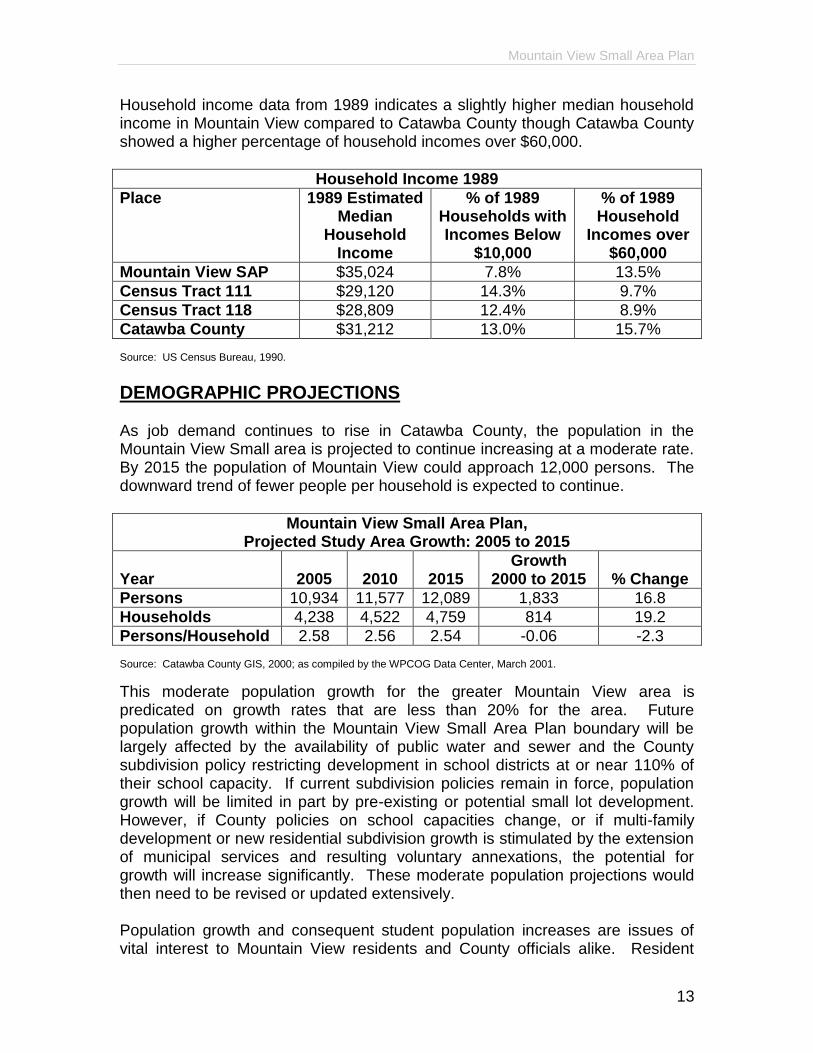
Household income data from 1989 indicates a slightly higher median household income in Mountain View compared to Catawba County though Catawba County showed a higher percentage of household incomes over $60,000.
Household Income 1989
Place 1989 Estimated Median
Household Income
% of 1989 Households with Incomes Below
$10,000
% of 1989 Household
Incomes over $60,000
Mountain View SAP $35,024 7.8% 13.5%
Census Tract 111 $29,120 14.3% 9.7%
Census Tract 118 $28,809 12.4% 8.9%
Catawba County $31,212 13.0% 15.7% Source: US Census Bureau, 1990.
DEMOGRAPHIC PROJECTIONS As job demand continues to rise in Catawba County, the population in the Mountain View Small area is projected to continue increasing at a moderate rate. By 2015 the population of Mountain View could approach 12,000 persons. The downward trend of fewer people per household is expected to continue.
Mountain View Small Area Plan, Projected Study Area Growth: 2005 to 2015
Year
2005
2010
2015
Growth 2000 to 2015
% Change
Persons 10,934 11,577 12,089 1,833 16.8
Households 4,238 4,522 4,759 814 19.2
Persons/Household 2.58 2.56 2.54 -0.06 -2.3 Source: Catawba County GIS, 2000; as compiled by the WPCOG Data Center, March 2001.
This moderate population growth for the greater Mountain View area is predicated on growth rates that are less than 20% for the area. Future population growth within the Mountain View Small Area Plan boundary will be largely affected by the availability of public water and sewer and the County subdivision policy restricting development in school districts at or near 110% of their school capacity. If current subdivision policies remain in force, population growth will be limited in part by pre-existing or potential small lot development. However, if County policies on school capacities change, or if multi-family development or new residential subdivision growth is stimulated by the extension of municipal services and resulting voluntary annexations, the potential for growth will increase significantly. These moderate population projections would then need to be revised or updated extensively. Population growth and consequent student population increases are issues of vital interest to Mountain View residents and County officials alike. Resident

Mountain View Small Area Plan
14
population in the Catawba County School system boundaries grew 25.6% from 74,267 to 93,670 persons during the 1990s. Fred T. Foard High School District experienced one of the largest population increases in Catawba County during the 1990s. Student increases provided the impetus for County and school officials to seek new ways of quantifying the components of student population change through Geographic Information System technology. The Western Piedmont Council of Governments produced The Catawba County Growth Estimation Model: Study of the Catawba County, Hickory, and Newton-Conover School Systems in conjunction with the Catawba County Schools, Hickory Public Schools and New-Conover City Schools. Findings from the report are discussed in the Community Facilities and Public Services section of this report.

Mountain View Small Area Plan
15
LAND USE AND COMMUNITY DESIGN
CURRENT CONDITIONS AND TRENDS
Current Land Use Residential uses and open space occupy the vast majority of land in the Mountain View study area. Accordingly, most parcels are zoned R-1, R-2 and R-3 with the bulk of the area falling into the R-2 district. The R-2 zoning district is intended to accommodate low density residential development, agriculture and the necessary governmental and support services in the more rural portions of the County. It permits modular and site-built homes, single-wide, and double-wide manufactured homes. It also includes bona fide farms. Commercial activity is concentrated in the northern portion of the study area along NC Highway 127. A few scattered businesses exist along Highway 127 South and at the intersection of Old Shelby Road and Henry River Road. The commercial areas are primarily zoned C-2, which allows regional type businesses. Fewer commercial parcels are zoned C-1, which permits community service type businesses. The few parcels zoned C-3, previously non-conforming businesses, are not allowed to expand their land use. Industrial and office-institutional uses within the study area are limited at this time. Many of the existing industrial uses in Mountain View are non-conforming. A use is classified as non-conforming if it was in existence prior to the implementation of zoning and the property was not zoned for that particular use. Non-conforming uses may continue their existence as long as they do not cease operation for more than 180 days but may be limited if proposed to expand. Southwood Reproductions, a furniture company, exists on NC Highway 127 south of NC Highway 10. Mountain View Elementary School, Jacobs Fork Middle School, Fred T. Foard High School, the Catholic Conference Center and several churches are the largest institutional uses in the study area. Bakers Mountain, the highest point in Catawba County, lies in the western portion of the study area. Thus far, the only development on Bakers Mountain consists of public and private communications equipment and the County’s Bakers Mountain park. The County’s park is a passive recreation facility on the northeast slope of the mountain. New single-family residential development is encroaching at the base of the mountain on the eastern side. Land uses in Mountain View also adhere to State mandated watershed regulations. The majority of the study area lies within the WS-III protected area, which allows up to one house per half acre and twenty-four percent lot coverage for business, multi-family and industrial uses. See Map 3, MVSAP Current Land Uses
Mountain View Small Area Plan
16
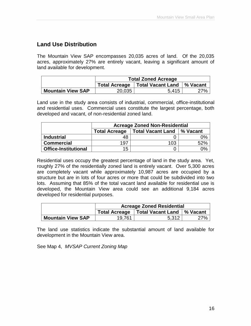
Land Use Distribution The Mountain View SAP encompasses 20,035 acres of land. Of the 20,035 acres, approximately 27% are entirely vacant, leaving a significant amount of land available for development.
Total Zoned Acreage
Total Acreage Total Vacant Land % Vacant
Mountain View SAP 20,035 5,415 27%
Land use in the study area consists of industrial, commercial, office-institutional and residential uses. Commercial uses constitute the largest percentage, both developed and vacant, of non-residential zoned land.
Acreage Zoned Non-Residential
Total Acreage Total Vacant Land % Vacant
Industrial 48 0 0%
Commercial 197 103 52%
Office-Institutional 15 0 0%
Residential uses occupy the greatest percentage of land in the study area. Yet, roughly 27% of the residentially zoned land is entirely vacant. Over 5,300 acres are completely vacant while approximately 10,987 acres are occupied by a structure but are in lots of four acres or more that could be subdivided into two lots. Assuming that 85% of the total vacant land available for residential use is developed, the Mountain View area could see an additional 9,184 acres developed for residential purposes.
Acreage Zoned Residential
Total Acreage Total Vacant Land % Vacant
Mountain View SAP 19,761 5,312 27%
The land use statistics indicate the substantial amount of land available for development in the Mountain View area. See Map 4, MVSAP Current Zoning Map

Mountain View Small Area Plan
17
Site Development Patterns and Land Design Trends Historically, Mountain View was largely a rural, agricultural community. Gradually, the larger homesteads were sold and subdivided for single-family homes. Site-built homes have predominated over manufactured and multi-family homes. The greatest residential growth has occurred in the northern and central portion of the study area along NC Highway 127 and Zion Church Road, leaving the southern and western areas more rural. Larger, undivided tracts of land exist in the western and southern portions of the area with most agricultural land located in the south. Commercial growth has also concentrated along NC Highway 127, north of Mountain Grove Road. Several businesses were voluntarily annexed by Hickory, primarily to obtain water and sewer services, and thus Hickory zones those parcels within the study area. Due to Hickory development standards, sidewalks, previously lacking in the Mountain View area, are gradually being added to businesses along Highway 127. Industrial activity, while limited to this point, is anticipated to increase significantly. The completion of US Highway 321 and the River Road interchange has made land in that area attractive to developers seeking large parcels of land with access to major transportation routes. The City of Hickory has purchased 150 acres at the River Road interchange with the intention of creating a business park consisting of office, commercial, light industrial and residential space. Recreational uses in Mountain View have consisted primarily of school and church facilities and Huffman Park. The private Mountain View Recreation Association operates Huffman Park and organizes leagues for team sports. In addition, the County created a passive recreation park on Bakers Mountain.

Mountain View Small Area Plan
18
GUIDING PRINCIPLES
P-1 Preserve rural character P-2 Protect property values P-3 Provide continuity in, and transition between, land uses P-4 Encourage housing options for people in all stages of life P-5 Manage growth opportunities and minimize undesired sprawl P-6 Encourage better subdivision design P-7 Require additional residential subdivision improvements P-8 Avoid retail strip shopping centers P-9 Create pedestrian friendly retail clusters in village-type developments P-10 Require more aesthetically pleasing designs from commercial uses P-11 Prevent over-commercialization P-12 Provide transition from residential to commercial districts P-13 Direct office-institutional uses to village-type developments that provide
residential services P-14 Separate industrial areas from residential areas P-15 Limit the amount of land dedicated to industrial uses P-16 Direct industrial uses to planned park developments P-17 Protect Bakers Mountain from undesired development P-18 Preserve the remaining farms and/or explore opportunities for conversion
to preserved open space P-19 Maintain rural atmosphere P-20 Protect scenic vistas

Mountain View Small Area Plan
19
PLAN RECOMMENDATIONS Mountain View residents prefer that Mountain View remain primarily residential with the exception of a few locations identified for commercial uses. LU-1 Designate an area for higher density residential uses, as shown on Map
5A, Proposed Density Districts for the MVSAP. See build-out scenario in Appendix B.
LU-2 Higher density developments should adhere to the following design
concepts:
.1 Cluster development options should be offered with a minimum open space preservation requirement of twenty-five percent (25%) and a sliding scale up to fifty percent (50%) with higher density bonuses;
.2 Single-family homes should be developed at a maximum density of 2 units per acre if water is not available and 2.5 units per acre if water is available, subject to approval by the County Environmental Health Department for septic;
.3 High density developments should not be subject to the availability of school capacity. See plan recommendations regarding schools on page 36.
LU-3 If utilities are available to support multi-family developments, the preferred
location for such developments would be along the US 321 corridor. LU-4 Designate an area for lower density residential uses, as shown on Map
5A. LU-5 Lower density residential areas should meet the following development
requirements:
.1 Cluster development is required with open space preserved along the road frontage unless a traditional subdivision design is developed that can incorporate open space preservation and buffers around the development. Density bonuses will be offered for development which provides additional open space above the minimum 30% requirement;
.2 Single-family homes should be developed at a density of 1 unit per 2 acres.
LU-6 Residential subdivisions should incorporate the following additional design
criteria:

Mountain View Small Area Plan
20
.1 Landscaping, limited driveways, road setbacks, buffers and/or berms that promote privacy, aesthetics and the scenic character of a new residential subdivision;
.2 Uniform subdivision marker signs;
.3 Sidewalks should be required for new developments along the road frontage of major thoroughfares.
LU-7 Minimum standards for land preparation at new residential subdivision
sites should be developed to minimize clear cutting of trees and the elimination of existing ground cover.
LU-8 The installation of underground utilities should be encouraged in all new
major residential subdivisions. LU-9 New residential subdivisions should include, where appropriate, the
dedication of land(s) for schools, parks and passive recreation uses needed to serve the development’s new residents.
LU-10 Encourage multiple access requirements into subdivisions. LU-11 Examine current parcel zoning designations at Propst Crossroads and
Advent Crossroads to:
.1 Define and regulate the extent of commercial activities in these retail nodes;
.2 Provide for a potential expansion of commercial development in these areas;
.3 Allow businesses that are intended to serve residents of the immediate area;
.4 Limit their square footage to reflect the character of the surrounding community and neighborhoods;
.5 Allow mixed uses (commercial and residential) within commercial structures;
.6 Propst Crossroads should be designated Neighborhood Commercial with a site area of 10 to 25 acres and maximum gross leasable area of 50,000 square feet per lot;
.7 Advents Crossroads should be designated Rural Commercial with a maximum site area of 10 acres and a maximum gross leasable area of 15,000 square feet per lot.
See Map 6, MVSAP Future Landuse Recommendations
LU-12 Identify and catalog all non-conforming commercial and industrial uses in the MVSAP boundary in order to monitor potential attempts at expansion, illegal continuances and/or changes to less conforming uses.

Mountain View Small Area Plan
21
LU-13 Review the current zoning regulations with respect to permitted uses for the C-1 and C-2 zones. Make appropriate changes regarding heavy commercial uses (e.g. tanker trucks, chain link fences etc.).
LU-14 Identify and catalog all non-conforming signs in the MVSAP boundary in
order to monitor potential attempts to locate new illegal signs, enlarge existing signs and continue illegal uses.
LU-15 Establish a mixed-use overlay district along a segment of NC Highway
127, as shown on Map 6, to address the following:
.1 Access management – including ingress/egress, interconnectivity between developments, the number of accesses per development, driveway requirements and turn lane requirements;
.2 Landscaping - including additional interior parking lot landscaping, buffering of adjoining uses and road frontage landscaping;
.3 Shopping center design – including parking, signage, landscaping, lighting, etc.;
.4 Commercial signage regulations – including the prohibition of billboards;
.5 Parking requirements – including the storage of commercial vehicles in front yards.
LU-16 The US 321/River Road interchange, as shown on Map 6, should be
designated for mixed-use development consisting of multi-family and commercial uses.
LU-17 Direct office-institutional uses to the US Highway 321 Corridor and River
Road interchange and NC Highway 127 overlay district, as shown on Map 6.
LU-18 Encourage office or institutional developments in park-like settings.
LU-19 Limit industrial uses to the US Highway 321 Corridor, as shown on Map 6. LU-20 If industrial uses are developed encourage light intensity uses in park-like
settings. LU-21 Preserve areas in floodplains and land around such known resources as
the Jacob Fork, the Henry Fork, Hop Creek and Bakers Mountain. LU-22 Preserve rural character in low density areas by limiting development even
if water and sewer are available. LU-23 Educate property owners of rural farms on ways of preserving those uses
by providing information on conservation easements and tax credit measures.
Mountain View Small Area Plan
22
LU-24 Create a mountain protection district in a defined area around Bakers
Mountain as a means of limiting future development on Bakers Mountain due to environmental concerns. See Map 7, MVSAP Natural and Cultural Resources.
LU-25 Develop a mechanism for preserving open space resources by seeking
legislation to create a transfer of development rights (TDR) type component for the zoning ordinance.

Mountain View Small Area Plan
23
TRANSPORTATION
CURRENT CONDITIONS AND TRENDS
Roads & Highways The Hickory-Newton-Conover Metropolitan Planning Organization (MPO) includes the Mountain View area for the purpose of planning and implementing transportation systems. Since its inception in 1983, the MPO has faced significant growth in retail, commercial and residential developments. Consequently, traffic congestion plagues many locations in the planning area, particularly in Mountain View. North Carolina Highway 127 South, a major north-south thoroughfare, serves the Mountain View area. In 1988 18,900 vehicles per day utilized Highway 127 near the northern end of the planning area. Vehicles per day grew to 24,800 in 1994. However, the 1999 count dropped to 19,000 vehicles per day.
NC Highway 127 South Northern End of Planning Area
Vehicles Per Day
1988 18,900 VPD
1994 24,800 VPD
1999 19,000 VPD
The decrease in vehicles per day is attributed to the new US 321 Freeway. US 321 is a controlled access freeway connecting Interstate 85 in Gastonia to the Hickory-Newton-Conover Urban Area. The freeway presently serves 25,000 vehicles per day in the River Road area. A new interchange with US 321 at Sandy Ford Road will further impact the Mountain View area. The new interchange construction is projected to be completed by 2010. While US 321 has alleviated some of the traffic congestion in Mountain View on NC Highway 127, continued growth in the Mountain View area will once again increase traffic. To reduce traffic congestion and adequately provide for future travel demands, the MPO adopted the Hickory-Newton-Conover Urban Area Transportation Plan in 1986 and updated the plan in 1996. A technical update of the Hickory-Newton-Conover Urban Area Transportation Plan was adopted on September 11, 2001. The primary objective of the thoroughfare plan is to assure that a street system can be progressively developed to adequately serve future travel needs. In the adopted MPO thoroughfare plan, the MPO addresses the needs of Highway 127. Traffic congestion in Mountain View is attributed to the capacity and design deficiencies of Highway 127. To remedy the existing deficiencies of Highway 127, the MPO recommends widening the road to multi lanes from US 321 to the Jacob Fork. The Catawba County Thoroughfare Plan recommends widening

Mountain View Small Area Plan
24
Highway 127 from the Jacob Fork to NC 10, an area outside of the MPO planning area. This project is listed on the State Transportation Improvement Program (STIP) as an unfunded project. Also recommended by the MPO and listed on the 2000-2006 STIP is the Southern Corridor. The Southern Corridor is a proposed four lane divided boulevard extending from I-40 in Long View to US 321-B in Newton. In addition to creating a regional loop, the Southern Corridor will expand the possibilities for development in the Mountain View area as well as provide an alternative route to Highway 127 for major thoroughfare trips.
Pedestrian System Presently, Catawba County does not regulate or require sidewalk construction. However, the City of Hickory requires sidewalks in all new developments. Hickory has jurisdiction over several parcels along Highway 127 in the Mountain View area. New developments within Hickory's jurisdiction are required to install sidewalks though they will not necessarily connect to other sidewalks at this time. Hickory also adopted a sidewalk plan that encourages linking sidewalks and greenways. In general, Mountain View lacks a pedestrian system offering options for connectivity between residential areas and commercial developments.
Bicycle System Due to the rural nature of the outlying areas, Mountain View is a popular area for bicyclists. To date, the MPO has installed "Share the Road" signs on Robinson Road, Sandy Ford Road and Zion Church Road. The NCDOT has also funded a Bicycle Route Map and signing project that will begin in late 2001 with expected completion in one year. A system of off-road bicycle trails does not exist in Mountain View.
Transit System The Piedmont Wagon Transit System (PWTS) offers limited transit service to Mountain View residents. Five days a week vans are available through the Piedmont Wagon to transport senior citizens and disabled residents in the Mountain View area. A rural general public fixed route began service in early 1999 that operates on Robinson Road, NC Highway 10 and NC Highway 127 two days per week. The service is open to anyone and operates on a fixed route and time. Plans are underway to expand this service in terms of frequency and service area.

Mountain View Small Area Plan
25
Passenger Rail
The NCDOT has determined that the next expansion of passenger rail service in the State will be in Western North Carolina. Plans are underway to initiate service between Raleigh and Asheville with a stop in downtown Hickory. A portion of the former Hickory depot, now entirely occupied by a restaurant, will return to a passenger waiting area. This service is expected to be operational within five years.

Mountain View Small Area Plan
26
GUIDING PRINCIPLES P-1 Reduce traffic congestion on NC Highway 127 P-2 Establish safer roads for drivers, pedestrians and bicyclists P-3 Create more aesthetically pleasing road designs P-4 Guide development to preserve future rights-of-way P-5 Support Hickory-By-Choice recommendations regarding transportation P-6 Maintain rural character P-7 Connect existing sidewalks and develop new ones P-8 Provide greenways and trails that link with sidewalks P-9 Promote road-sharing with bicyclists P-10 Increase pavement width on designated roads to accommodate bicyclists P-11 Offer off-road bicycling options P-12 Expand the public transportation service area and frequency of trips P-13 Help transportation dependent citizens, i.e., seniors, disabled persons and
non-drivers, obtain mobility P-14 Promote links with other transit modes to support a seamless
transportation network P-15 Increase independence for transportation dependent residents

Mountain View Small Area Plan
27
PLAN RECOMMENDATIONS Catawba County does not maintain roads; therefore, the following recommendations will be forwarded to NCDOT or used in areawide thoroughfare planning. T-1 Install traffic signals and/or redesign intersections at:
.1 Blackburn School and NC Highway 10
.2 Bethel Church Road and Zion Church Road.
T-2 Evaluate safety and design of: .1 Advent Crossroads .2 Homestead Subdivision .3 NC Highway 10 and Zion Church Road.
T-3 Develop a future street-line ordinance to protect future rights-of-way from
development. T-4 Create an outdoor advertising ordinance and evaluate permitting outdoor
advertising on designated roads to reduce existing sign clutter and preserve rural views.
T-5 Designate the following as local, state or federal scenic highways:
.1 US Highway 321
.2 Old Shelby Road
.3 Greedy Highway
.4 Finger Bridge Road
.5 Henry River Road
.6 Zion Church Road
.7 NC Highway 127 T-6 Establish a commercial overlay district on NC Highway 127 (see Map 6)
that will address access management, landscaping, signage, lighting, setbacks, sidewalks and other land use development standards.
T-7 Widen NC Highway 127 to four lanes with a landscaped median. T-8 Continue to support the completion of construction of US Highway 321
interchange at Sandy Ford Road. T-9 Upgrade existing roads and evaluate the need for new connectors
between US Highway 321 and NC Highway 127. T-10 Continue to support the construction of the Southern Corridor. The
preferred design for the Southern Corridor is four lanes with a landscaped median.

Mountain View Small Area Plan
28
T-11 Designate the southern portion of the Southern Corridor from Zion Church Road to NC Highway 127 as a higher construction priority.
T-12 Implement a pedestrian plan/sidewalk ordinance. Areas with the greatest
need should be a priority, including urbanized areas, major roads, schools and parks. The pedestrian plan/sidewalk ordinance should require new developments on major thoroughfares provide sidewalks and bicycle lanes on the thoroughfare frontage to connect with existing or proposed sidewalks and bicycle lanes.
T-13 Recommend that Hickory connect sidewalks within its jurisdiction. T-14 Develop a plan to create a greenway for pedestrians and bicyclists. The
preferred routes for the greenways would be along the Henry and Jacob Forks, Duke Power right-of-ways and Bakers Mountain.
T-15 Implement the greenway plan. T-16 Create linkages between residential, commercial and industrial
developments. Ideally, commercial and residential developments would be connected to public institutions (i.e. Mountain View Elementary School) and recreational facilities.
T-17 Add an extra one to two feet of asphalt when re-paving existing roads to
allow for safer road sharing between bicycles and automobiles. Roads that should be widened include Robinson Road, Sandy Ford Road, Zion Church Road, Old Shelby Road, Mountain Grove Road and Pittstown Road.
T-18 Major projects such as the NC Highway 127 widening and the new
Southern Corridor should be designed to accommodate bicyclists. T-19 Create a greenway system for pedestrians and bicyclists. The preferred
routes for the greenways would be along the Henry and Jacob Forks, Duke Power right-of-ways and Bakers Mountain.
T-20 Develop an off-road system of bicycle trails to connect with the greenway
system. Bakers Mountain would be an ideal location for such trails. T-21 Publicize existing services offered by Piedmont Wagon. T-22 Support short-range recommendations of the Piedmont Wagon Public
Transit Master Plan. T-23 Expand Rural General Public (RGP) routes and frequency of service.

Mountain View Small Area Plan
29
T-24 Support mid-range recommendations of the Piedmont Wagon Public Transit Master Plan.
T-25 Connect with the regional transit system. T-26 Support long-range recommendations of the Piedmont Wagon Public
Transit Master Plan. T-27 Encourage local elected officials to lobby the North Carolina General
Assembly to budget full funding for the creation of Western North Carolina passenger rail service.
T-28 Promote the development of multi-modal transportation systems to link
with passenger rail service. T-29 Expand the frequency of passenger rail service. T-30 Continue the development of linkages with public transportation services. T-31 Establish “gateway” improvements in the area which may include
landscaping and welcome signs. Funding for these improvements may come from Federal or State grants.
See Map 8, MVSAP Current, Planned and Recommended Transportation System
Mountain View Small Area Plan
30
COMMUNITY FACILITIES AND PUBLIC SERVICES CURRENT CONDITIONS AND TRENDS
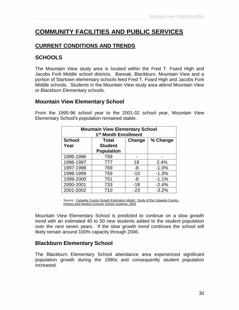
SCHOOLS The Mountain View study area is located within the Fred T. Foard High and Jacobs Fork Middle school districts. Banoak, Blackburn, Mountain View and a portion of Startown elementary schools feed Fred T. Foard High and Jacobs Fork Middle schools. Students in the Mountain View study area attend Mountain View or Blackburn Elementary schools.
Mountain View Elementary School From the 1995-96 school year to the 2001-02 school year, Mountain View Elementary School's population remained stable.
Mountain View Elementary School 1st Month Enrollment
School Year
Total Student
Population
Change % Change
1995-1996 759 - -
1996-1997 777 18 2.4%
1997-1998 769 -8 -1.0%
1998-1999 759 -10 -1.3%
1999-2000 751 -8 -1.1%
2000-2001 733 -18 -2.4%
2001-2002 710 -23 -3.2%
Source: Catawba County Growth Estimation Model: Study of the Catawba County,
Hickory and Newton-Conover School Systems, 2001
Mountain View Elementary School is predicted to continue on a slow growth trend with an estimated 40 to 50 new students added to the student population over the next seven years. If the slow growth trend continues the school will likely remain around 100% capacity through 2006.
Blackburn Elementary School The Blackburn Elementary School attendance area experienced significant population growth during the 1990s and consequently student population increased.

Mountain View Small Area Plan
31
Blackburn Elementary School is currently at capacity and over the next seven years nearly 200 additional students are projected. By 2007 the school could reach 130% building capacity.
Blackburn Elementary School 1st Month Enrollment
School Year
Total Student
Population
Change % Change
1995-1996 546 - -
1996-1997 570 24 4.4%
1997-1998 578 8 1.4%
1998-1999 626 48 8.3%
1999-2000 649 23 3.7%
2000-2001 677 28 4.3%
2001-2002 662 -15 -2.3%
Source: Catawba County Growth Estimation Model: Study of the Catawba County,
Hickory and Newton-Conover School Systems, 2001
Jacobs Fork Middle and Fred T. Foard High Schools Both Jacobs Fork Middle and Fred T. Foard High schools experienced growth in the 1990s.
1st Month Enrollment
Jacobs Fork Middle School Fred T. Foard High School
Year Total Student
Population
Change % Change
Total Student
Population
Change % Change
1995 564 - - 974 - -
1996 555 -9 -1.6% 980 6 0.6%
1997 586 31 5.6% 1,028 48 4.9%
1998 637 51 8.7% 1,034 6 0.6%
1999 620 -17 -2.7% 1,090 56 5.4%
2000 628 8 1.3% 1,141 51 4.7%
2001 676 48 7.1% 1,182 41 3.5% Source: Catawba County Growth Estimation Model: Study of the Catawba County, Hickory and Newton-Conover School Systems, 2001
Jacobs Fork Middle School is currently at 90% capacity with a predicted peak of 800 students by 2005. In 2000 Fred T. Foard High School was 241 students over the original building capacity.

Mountain View Small Area Plan
32
PARKS AND GREENWAYS School and church facilities as well as Huffman Park comprise the recreational facilities in the Mountain View study area. The Mountain View Recreation Association operates Huffman Park, located on Highway 127, and organizes leagues for team sports. In June 2002, Catawba County opened a passive recreation park on Bakers Mountain. The Bakers Mountain Park includes 196 acres of passive recreational opportunities for residents of Catawba County and surrounding areas. Of the 196 acres, only 8.8 acres are disturbed to provide 25 parking spaces, picnic areas and scrub growth removal from meadow areas. Two and one-half miles of trails with a one-quarter mile paved handicap accessible trail are provided.
LIBRARIES The Southwest Branch of the Catawba County library system is located on Highway 127 South in the Mountain View study area. The Southwest Branch serves residents six days per week May through August and seven days per week September through April. Currently, there are 6,021 registered library users at the Southwest Branch. As of October 2001 the library has 26,789 books and six public access computers. Programs offered by the library include weekly preschool and toddler story times, special presentations for school groups and occasional youth or adult programs. The Southwest Branch Library is located in a shopping center and is six years into a ten-year lease, which expires October 1, 2006. A library facility study is underway to investigate the possibility of a permanent structure, perhaps at Propst Crossroads.
WATER SERVICE The City of Hickory and Catawba County have partnered to provide water service to schools within the Mountain View area of Catawba County. When the County pays for water lines in the unincorporated areas of the County, the cities maintain the lines and then the city and County share the revenues collected. The existing water lines in the Mountain View area are along Highway 127 throughout the study area; Zion Church Road from Highway 321 to Sandy Ford Road; River Road from Highway 321 to Sandy Ford Road; Highway 10 from Propst Crossroads west; Huffman Farm Road from Highway 127 to Pittstown Road; Old Farm Road; and Bethel Church Road from Highway 127 to Wallace Dairy Road. Two new water lines, to be located on Mountain Grove Road to Advents Crossroads and in the Jamestown Subdivision, are currently being installed and are expected to be complete by July 1, 2002.
Mountain View Small Area Plan
33
SEWER SERVICE The City of Hickory currently has sewer lines in a few locations bordering the Mountain View study area. Along Highway 127 there is a line from the study area boundary to Frye Avenue. Another line runs along Wallace Dairy Road from Elizabeth Avenue northeast to Zion Church Road, then north along Zion Church Road to Bowman Road, then east along Bowman Road to the Henry Fork, then following the Henry Fork to Thompson Street. In a recent sewer study the City has recommended an additional main trunk line in the Highway 321/River Road area.
EMERGENCY SERVICES Catawba County's E911 Center dispatches emergency calls throughout Catawba County, including the police, fire and EMS serving Mountain View residents.
Police The main element of the Catawba County Sheriff's Department is the Uniform Patrol Division. Twenty-six officers comprise this Division and provide patrol 24 hours per day.
Fire Mountain View Fire Department and Propst Crossroads Volunteer Fire Department serve Mountain View residents. The Mountain View Fire Department was chartered in 1962 and is located on Highway 127 South. In addition to the fire chief, a full-time employee, two captains, three lieutenants, a traffic officer and thirty suppression volunteers comprise the Mountain View Fire Department. On average the Mountain View Fire Department responds to 150 calls per year. The Propst Crossroads Volunteer Fire Department was formed in the early 1960s to serve the southwest area of Catawba County. Twelve board of directors oversee the Propst Crossroads Volunteer Fire Department which consists of a Chief and Assistant Chief and 40 members.
Mountain View Small Area Plan
34
EMS Catawba County has six EMS stations with the closest stations to the Mountain View study area being at Propst Crossroads and on Lenior-Rhyne Boulevard in Hickory. The EMS providers average a response time of eight minutes or less and are capable of stabilizing patients at the scene of an emergency and providing basic and/or advanced life support. In 1999 the EMS providers responded to 1,398 calls in the Mountain View area. Catawba County is looking to add an additional EMS station at the intersection of Highway 127 and Zion Church Road.

Mountain View Small Area Plan
35
GUIDING PRINCIPLES P-1 Plan school capacity to alleviate overcrowding of facilities P-2 Provide additional recreation opportunities for all age groups P-3 Promote cultural events and facilities P-4 Combine passive recreation and open space preservation interests P-5 Link recreational facilities with residential developments P-6 Maintain a branch library in the Mountain View community P-7 Encourage water and sewer services in areas dedicated for higher density
development and elsewhere to alleviate environmental issues P-8 Address failing water systems P-9 Maintain current level of emergency services P-10 Retain EMS in a centralized area

Mountain View Small Area Plan
36
PLAN RECOMMENDATIONS In general, the MVSAP recommends grouping County facilities (i.e. library, EMS, recreation facility, schools) at a centralized location in high density areas with water/sewer service and access to major transportation routes. CF-1 The current school capacity requirement would be lifted for the high
density residential areas as shown on Map 5A. CF-2 Identify ideal sites for additional schools and begin acquiring land for
future school needs. CF-3 Assess the availability of infrastructure to support a school when
evaluating a potential site. CF-4 Coordinate with school facility planners to review potential sites for new
schools. CF-5 Additional industrial zoning should not be encouraged around Fred T.
Foard High School and Jacobs Fork Middle School. CF-6 The Catawba County Board of Education approved a Long Range Plan in
September 2000 to address school construction bond priorities, annual capital outlay requests and additional capital needs for 2001 through 2006. The MVSAP Committee reviewed the Long Range Plan and supports the goals, which, at Fred T. Foard High School, include:
2001-2002 .1 Classroom addition .2 New administrative area .3 New media center .4 Renovation of existing media center 2002-2003 .5 New gymtorium .6 New cafeteria .7 Renovate existing cafeteria .8 Update football stadium
CF-7 Continue to support the development of County park facilities on Bakers
Mountain. CF-8 Acquire land or increase pavement width on existing roads to construct
bicycle lanes connecting Bakers Mountain Park and the Henry Fork Regional Recreation Park.
CF-9 Provide canoe and raft portage points on the Henry Fork and Jacob Fork.
Mountain View Small Area Plan
37
CF-10 Create trails along the Henry and Jacob Forks to accommodate the needs
of hikers, bicyclists and equestrians. CF-11 Require new developments on major thoroughfares (i.e. NC Highway 127,
Zion Church Road, Bethel Church Road, Wallace Dairy Road) provide sidewalks and bicycle lanes on the thoroughfare frontage to connect with existing or proposed sidewalks and bicycle lanes.
CF-12 Expand the Mountain View Branch Library to keep pace with growth in the
community. CF-13 Continue to support the library facility study. CF-14 Designate areas for utility expansion, direct growth in those areas and
require utility placement prior to development. CF-15 Partner with municipalities to provide utilities consistent with adopted land
use plans. CF-16 Increase services to keep pace with growth in the community. CF-17 The County should actively recruit an urgent care facility for the Mountain
View community.

Mountain View Small Area Plan
38
HOUSING CURRENT CONDITIONS AND TRENDS Population growth in Mountain View contributed to growth in the number of housing units in the study area. Mountain View experienced 24% growth in population from 1990 to 2000 with continued growth projected. Housing growth may be tracked through building permits. Building permits are issued for any new construction and are recorded at the Census Tract level. The Mountain View study area is located within portions of Census Tracts 111 and 118. See Map 2. The following table breaks down the total number of building permits issued from 1995 through 1999 in Census Tracts 111 and 118 by type of home, single-family site-built, multi-family and manufactured.
Catawba County Residential Building Permits by Census Tract 1995-2000
Tract
Single-Family Site-Built
Manufactured Homes
Multi-Family
111 337 126 23
118 475 545 15
Total 812 671 38 Source: Catawba County and City of Hickory Building Inspection Departments, 1995-2000.
Single-family site-built and manufactured homes received the same number of total permits. However, the Mountain View study area includes almost all of Census Tract 111 yet only a portion of Tract 118. Census Tract 118 had significantly more manufactured home permits than Tract 111, as evidenced by the trend in Mountain View for single-family site-built homes. Few multi-family permits have been issued, due primarily to the lack of water and sewer service needed to serve higher density developments. In general, the number of manufactured home permits being issued is decreasing while single-family site-built permits are increasing in Catawba County.
Catawba County Residential Permits 1995-2000
Year
Single-Family Site-Built Permits
ManufacturedHome
Permits
Multi-Family Permits
1995 628 838 41
1996 812 729 157
1997 787 666 104
1998 835 739 159
1999 949 651 79
2000 995 539 165 Source: City of Hickory and Catawba County Building Inspections Departments, 1995-2000

Mountain View Small Area Plan
39
GUIDING PRINCIPLES P-1 Encourage more aesthetically pleasing subdivision designs P-2 Encourage the preservation of open space as development increases P-3 Direct multi-family housing to appropriate locations P-4 Provide for the location of manufactured homes P-5 Promote low maintenance, alternative housing opportunities for seniors
Mountain View Small Area Plan
40
PLAN RECOMMENDATIONS H-1 Residential subdivisions should incorporate additional design criteria to
address signage, landscaping, tree retention and environmental issues as identified in the land use section.
H-2 A pedestrian plan/sidewalk ordinance should be implemented to require
new developments on major thoroughfares provide sidewalks and bicycle lanes on the thoroughfare frontage to connect with existing or proposed sidewalks and bicycle lanes.
H-3 Rezone the areas shown on Map 9, MVSAP Proposed Zoning Map
Amendments to R-1. R-1 zoning allows for stick-built and modular homes. The proposed rezoning would create a continuous corridor of R-1 zoning along Highway 127, provide a buffer around existing subdivisions and zone land consistent with existing single-family site-built subdivisions.
H-4 Designate the US Highway 321 corridor and the interchange at River
Road for multi-family development. See Map 6. H-5 Patio homes, townhomes and similar structures, as well as apartments,
are a part of the overall recommendation for multi-family developments. H-6 Direct manufactured homes to areas zoned R-2. H-7 Amend the current zoning ordinance to require non-conforming
manufactured homes be replaced with doublewide homes when a property owner requests to replace a home.
H-8 The County should create more opportunities for retirement housing
communities. The County Agency on Aging should recruit developers of progressive care communities.
H-9 Allow density bonuses to developers when they provide starter housing
stock in residential and mixed-use developments.

Mountain View Small Area Plan
41
ECONOMIC DEVELOPMENT
CURRENT CONDITIONS AND TRENDS Catawba County experienced a shift in industry over the past twenty years from the historically dominant textile and furniture industries to the manufacturing of fiber optic cable, coaxial cable, satellites and electronic equipment. The Mountain View study area has limited existing industrial development, 48 acres, and residents wish to maintain that status. Many of the existing industrial uses in Mountain View are non-conforming. A use may be classified as non-conforming if it was in existence prior to the implementation of zoning and when the property was zoned it was not zoned for that particular use. Non-conforming uses may continue their existence as long as they do not cease operation for more than 180 days, but will be limited if proposing to expand. With the completion and opening of US Highway 321, development pressures are inevitable along the corridor. To promote sound development in the vicinity of US 321, Catawba County adopted the US 321 Corridor District Plan. The US 321 Corridor District Plan called for the creation of the 321-ED District to implement the strategies and policies of the Plan. The 321-ED District includes the 321-ED(MX) and the 321-ED(I) zoning designations. Approximately 2000 acres in the US Highway 321 corridor were proactively rezoned by the Catawba County Commissioners to ED(I), light manufacturing, and 321-ED(MX). Any combination of retail, commercial, office/institutional and residential components (excluding large lot single-family homes) are permitted in the 321-ED(MX). Within the Mountain View SAP boundary roughly 121 acres at the US Highway 321 interchange with River Road are zoned ED(MX). The US 321 Corridor District Plan also called for an urban transition zone to serve a multipurpose role. The urban transition zone would serve as a buffer between residential and non-residential uses, allow office and higher density residential development and identify potential land for more intense non-residential uses in the future. The Mountain View SAP endorses the US 321 Corridor District Plan.
Mountain View Small Area Plan
42
GUIDING PRINCIPLES P-1 Create more aesthetically pleasing developments P-2 Encourage retail villages P-3 Attract additional service establishments, i.e. restaurants P-4 Limit industrial development P-5 Continue to separate industrial uses from residential uses P-6 Direct industrial uses to appropriate locations with adequate water/sewer
services and access to transportation routes

Mountain View Small Area Plan
43
PLAN RECOMMENDATIONS ED-1 Designate a mixed-use corridor along NC Highway 127, as shown on Map
6, and create an overlay district to address aesthetic and safety issues as identified in the land use section.
ED-2 Include areas of transition in the US 321 Highway corridor on the future
land use plan. See Map 6. The transition areas should include activities such as:
.1 Office developments .2 Neighborhood retail/commercial and entertainment uses .3 Public facilities .4 Mixed-use developments
ED-3 Designate the US 321 Highway corridor as a scenic highway and adopt
appropriate regulations to protect the scenic quality of the area as development occurs. See transportation section and Map 8.
ED-4 Designate the northeast quadrant of the interchange at US Highway 321
and River Road as ED(I) for future industrial development. See Map 6. ED-5 Industrial uses, if developed, should be constructed in an attractive park-
like setting without heavy traffic, air and noise pollution. Light industrial uses should be the focus of such development.
Mountain View Small Area Plan
44
NATURAL RESOURCES
CURRENT CONDITIONS AND TRENDS Mountain View residents identify natural resources, such as Bakers Mountain, farms, open space and scenic topography as significant community assets. Several strategies to protect these natural resources are already in place while other strategies were discussed in the Strategic Growth Plan and are further supported by the Mountain View Small Area Plan.
RIVERS To protect water quality, the State of North Carolina enacted the Water Supply Watershed Protection Program in 1989. The Program requires all local governments with land use planning jurisdiction in water supply areas to administer a water supply watershed protection ordinance to protect surface drinking water. The majority of the Mountain View study area falls within the WS-III Protected Area Watershed. WS-III Protected Areas are limited to two dwelling units per acre. Multi-family, business, church and industrial uses are limited to 24% impervious lot coverage though non-residential uses may apply for a 5/70 exception. The 5/70 exception is granted through the special use permit process and allows up to 5% of the land in the watershed to be developed at 70% coverage.
BAKERS MOUNTAIN Bakers Mountain is a predominant landmark in Mountain View and Catawba County. Thus far, the only development on Bakers Mountain consists of public and private communications equipment. Catawba County developed a 196-acre passive recreation park on the northeast slope of Bakers Mountain. New single-family residential development is encroaching at the base of the mountain on the eastern side. In 1989 Catawba County amended the County Zoning Ordinance to include a Mountain Protection District. The Mountain Protection District is intended to protect native flora and fauna on the mountains, avoid severe disruption adjacent to and downstream from the mountains, preserve the physical integrity of the mountains' surface and ensure the continuation of their landmark status. However, the Mountain Protection District was never designated anywhere on the official Zoning Map for Catawba County.
Mountain View Small Area Plan
45
OPEN SPACE AND SCENIC TOPOGRAPHY Mountain View residents named rural character, including low density development, open space, farms and scenic topography as characteristics they value in Mountain View. Of the 20,035 acres in Mountain View approximately 5,415 acres are entirely vacant. Another 10,987 acres are occupied by a structure but are in large tracts of at least four acres. The vast amount of vacant land contributes to the rural character of Mountain View, yet also makes the community vulnerable to significant development. The Strategic Growth Plan suggested the creation of several programs, such as voluntary transfer of development rights, purchase/lease of development rights and voluntary farmland preservation to assist property owners in maintaining their current rural use and preserving open space for the community.
Mountain View Small Area Plan
46
GUIDING PRINCIPLES P-1 Protect water quality P-2 Preserve the scenic quality of river corridors P-3 Utilize rivers for environmentally sound recreational activities P-4 Minimize impacts of residential development P-5 Provide recreational opportunities P-6 Maintain rural character P-7 Preserve open space P-8 Assist farmers/property owners desiring to maintain the agricultural or
open space use of their property P-9 Protect scenic corridors and views as well as wildlife corridors

Mountain View Small Area Plan
47
PLAN RECOMMENDATIONS During a community meeting held at the onset of the Mountain View SAP process, residents overwhelmingly stated that rural character was the amenity that they valued most in the community. Much of Mountain View’s rural character is linked to natural resources such as Bakers Mountain, Henry and Jacob Forks, open space and scenic vistas. Residents also realized that the rural character and natural resources of the area were being threatened by development. With these factors in mind, the Mountain View SAP committee discussed means to preserve rural character through the protection of natural resources. The following recommendations are intended to begin a process and develop guidelines to preserve what is essentially “Mountain View.” NR-1 Create scenic and wildlife corridors by utilizing rivers, such as the Henry
Fork and Jacob Fork, and floodways for open space planning. NR-2 Establish standards for new development on Bakers Mountain above 1100
feet in the area designated as “Mountain Protection” on Map 7. All new major subdivisions will be subject to a planned development process which will address the following:
.1 lot clearing limits based on percent slope .2 height restrictions
.3 building material and finishes of homes and signage to be compatible with the natural environment
.4 environmentally sensitive road and lot configurations The average density allowable is one unit per two acres. To minimize the impacts to environmentally sensitive areas, the transferring of densities within the development will be strongly encouraged.
NR-3 Complete initial plans for Bakers Mountain Park and protect undeveloped
land within the Park. NR-4 Set as priority the purchase of additional land on Bakers Mountain for
future expansion of the Park. NR-5 Preserve green space in undisturbed, natural states to support wildlife
corridors. NR-6 Designate scenic highways identified in the transportation section and
Map 8.
NR-7 Educate farmers/property owners regarding programs available to assist them in maintaining the current use of their property.
Mountain View Small Area Plan
48
NR-8 Design and implement a recreation/open space plan to link Bakers Mountain Park with Henry Fork Regional Recreation Park.
The above recommendations come together as shown on Map 7, which illustrates the future vision of rural character, natural resources and recreation in the community. The recommendation calls for two focal points, Bakers Mountain Park and Henry Fork Park, with trails connecting the two. An additional trail would link Bakers Mountain Park with the Jacob Fork. Trails would then follow the Jacob and Henry Forks with opportunities for hikers, bicyclists and horses as well as canoeists.
Mountain View Small Area Plan
49
CULTURAL RESOURCES
CURRENT CONDITIONS AND TRENDS In the early nineteenth century agriculture was the dominant livelihood of North Carolinians. Today, Mountain View residents identify the remaining agricultural uses contributing to the rural character they enjoy and wish to preserve. A few of the historic sites remaining in the Mountain View area are described below. Built in 1903 near Propst Crossroads, the Sharpe-Gentry Farm exemplifies a Queen Anne style house with a barn and granary. The Sharpe-Gentry Farm is listed on the National Register of Historic Properties. Yoder’s Mill, located east of Zion Lutheran Church, is preserved as an archeological site today. Molasses and lumber were produced at Yoder’s Mill, circa 1857. Zion Lutheran Church and cemetery were organized in 1790 and became the first exclusively Lutheran Church in North Carolina west of the Catawba River. Yoder’s Mill produced handmade brick for the church. Bethel United Church of Christ and cemetery date to 1880 and exemplify Gothic Revival styling. See Map 7.

Mountain View Small Area Plan
50
GUIDING PRINCIPLES P-1 Recognize and protect cultural resources

Mountain View Small Area Plan
51
PLAN RECOMMENDATIONS CR-1 Request that the Catawba County Historical Association identify bona-fide
historical sites in the MVSAP. CR-2 Provide Catawba County Planning with a database of historical sites so
that proposed developments on or near significant historical areas can be flagged and encouraged to preserve the character of the area.
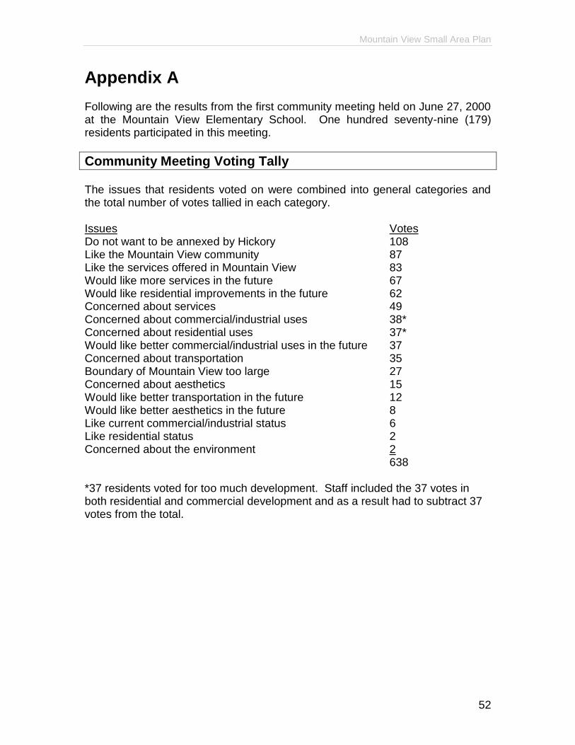
Mountain View Small Area Plan
52
Appendix A Following are the results from the first community meeting held on June 27, 2000 at the Mountain View Elementary School. One hundred seventy-nine (179) residents participated in this meeting.
Community Meeting Voting Tally The issues that residents voted on were combined into general categories and the total number of votes tallied in each category. Issues Votes Do not want to be annexed by Hickory 108 Like the Mountain View community 87 Like the services offered in Mountain View 83 Would like more services in the future 67 Would like residential improvements in the future 62 Concerned about services 49 Concerned about commercial/industrial uses 38* Concerned about residential uses 37* Would like better commercial/industrial uses in the future 37 Concerned about transportation 35 Boundary of Mountain View too large 27 Concerned about aesthetics 15 Would like better transportation in the future 12 Would like better aesthetics in the future 8 Like current commercial/industrial status 6 Like residential status 2 Concerned about the environment 2 638 *37 residents voted for too much development. Staff included the 37 votes in both residential and commercial development and as a result had to subtract 37 votes from the total.

Mountain View Small Area Plan
53
The general categories listed above are broken out below to show the specific issues that residents voted on. If an issue has (0) beside it, that indicates that the issue was listed for voting but no one voted for it. If an issue does not have a number after it that means the issue was not listed for voting but was discussed in the group sessions or written on a notecard.
What do you like about Mountain View? Community - 87
Rural character (59) Bakers Mountain (16), low density, open space, slower pace, long
time property owners, farms, topography, scenic Churches (5) Location (4)
accessible to stores/retail/urban areas/highway, not as congested Recreation (2) People (1)
diversity, community involvement/spirit, family atmosphere Services - 83
No city taxes (57) unincorporated
Schools (16) Library (9) Adequate zoning (1) Roads (0) Fire Department and EMS
safety Post office
Commercial/Industrial - 6
Little or no industry (3) One stop shopping (3)
Residential - 2
Affordable housing (2) Neighborhoods
good, clean, affordable
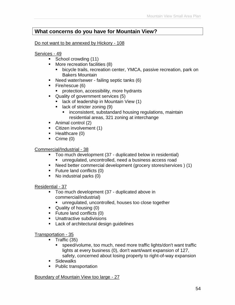
Mountain View Small Area Plan
54
What concerns do you have for Mountain View? Do not want to be annexed by Hickory - 108 Services - 49
School crowding (11) More recreation facilities (8)
bicycle trails, recreation center, YMCA, passive recreation, park on Bakers Mountain
Need water/sewer - failing septic tanks (6) Fire/rescue (6)
protection, accessibility, more hydrants Quality of government services (5)
lack of leadership in Mountain View (1) lack of stricter zoning (9)
inconsistent, substandard housing regulations, maintain residential areas, 321 zoning at interchange
Animal control (2) Citizen involvement (1) Healthcare (0) Crime (0)
Commercial/Industrial - 38
Too much development (37 - duplicated below in residential) unregulated, uncontrolled, need a business access road
Need better commercial development (grocery stores/services ) (1) Future land conflicts (0) No industrial parks (0)
Residential - 37
Too much development (37 - duplicated above in commercial/industrial) unregulated, uncontrolled, houses too close together
Quality of housing (0) Future land conflicts (0) Unattractive subdivisions Lack of architectural design guidelines
Transportation - 35
Traffic (35) speed/volume, too much, need more traffic lights/don't want traffic
lights at every business (0), don't want/want expansion of 127, safety, concerned about losing property to right-of-way expansion
Sidewalks Public transportation
Boundary of Mountain View too large - 27
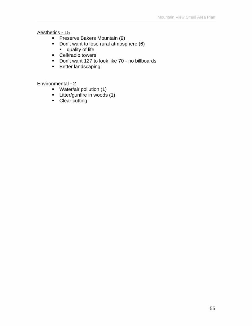
Mountain View Small Area Plan
55
Aesthetics - 15 Preserve Bakers Mountain (9) Don't want to lose rural atmosphere (6)
quality of life Cell/radio towers Don't want 127 to look like 70 - no billboards Better landscaping
Environmental - 2
Water/air pollution (1) Litter/gunfire in woods (1) Clear cutting

Mountain View Small Area Plan
56
What is your future vision of Mountain View? Services - 67
Recreation facilities (39) scenic by-way, cultural events and facilities (13), park, YMCA,
greenway, bikeway/sidewalks (9), park on Bakers Mountain Keep school districts (4)
more schools Urgent care center (2) Study impact fees
Residential - 62
No public housing (49) Retirement village (5) Lot sizes - minimum 1 acre + (3)
2 - 3 acre lots, 1/2 acre + lots, Limited multi-family housing (2) Restrictions on mobile home parks (2) Affordable, but no multi-family, housing (1)
Commercial/Industrial - 37
Light/little commercial - no strip malls - create retail villages (25) one-stop, mixed, shopping, mom & pop stores, separate from
residential, no big boxes, environmentally safe, landscaping, aesthetics, keep business north of fire department on 127
Industry away from residential areas (10) Newspaper (1) Restaurant (1)
Incorporate as Mountain View - 30 Transportation - 12
127 - more lanes (10) Road improvement (2) Traffic control Truck by-pass Lights on 127
Aesthetics - 8
Keep farms (6) Beautification (2) Keep 321 rural (0) Subdivision buffers Preserve highway corridors Keep rural