mountain driveway best management practices manual · mountain driveway best management practices...
TRANSCRIPT

Mountain DrivewayBest ManagementPractices Manual
Mountain DrivewayBest ManagementPractices Manual
Prepared for
The Colorado Nonpoint Source Council
Prepared by
Wright Water Engineers, Inc.and
Denver Regional Council of Governments
September 1999

Mountain Driveway
Best Management Practices Manual
Prepared for
The Colorado Nonpoint Source Council
Prepared by
Wright Water Engineers, Inc. 2490 West 26th Avenue, Suite 100A Denver, CO 80211 303-480-1700
and
Denver Regional Council of Governments 2480 West 26th Avenue, Suite 200B Denver, CO 80211 303-480-6766
Document Prepared Under Clean Water Act Section 319 Nonpoint Source Grant Funding
(Contract #WQC9808703)
June 1999 (revised September 1999)

Mountain Driveway Best Management Practices Manual September 1999
Page i
Table of Contents Acknowledgments ...................................................................................................................... iii
Limitations on Use of this Manual............................................................................................... iii
Background................................................................................................................................ 1
Introduction ................................................................................................................................ 1
Pre-Construction Planning ......................................................................................................... 2
Mountain Driveway BMPs................................................................................................7
Minimize Disturbance of Vegetation/Wetland ............................................................................. 8
Stormwater Diversion During Construction................................................................................. 9
Vehicle Tracking Pad ............................................................................................................... 10
Straw Bales .............................................................................................................................. 11
Sand Bags ............................................................................................................................... 13
Silt Fence ................................................................................................................................. 14
Sediment Traps........................................................................................................................ 16
Sediment Basins ...................................................................................................................... 18
Brush Barriers .......................................................................................................................... 19
Check Dams ............................................................................................................................ 20
Vegetation Buffers.................................................................................................................... 22
Grass-lined Swales .................................................................................................................. 24
Revegetation ............................................................................................................................ 26
Mulching................................................................................................................................... 27
Erosion Control Blankets.......................................................................................................... 28
Slope Stabilization.................................................................................................................... 30
Slope Drains............................................................................................................................. 31
Road Drainage ......................................................................................................................... 33
Drainageway Protection ........................................................................................................... 36
Outlet Protection ...................................................................................................................... 37
Infiltration Practices.................................................................................................................. 38
Stream Crossings..................................................................................................................... 39
Source Controls ....................................................................................................................... 41

Mountain Driveway Best Management Practices Manual September 1999
Page ii
Winter Maintenance: Sanding and Snow Removal.................................................................. 42
References For More Information............................................................................................. 43
Appendix 1 Representative Seed Mixes for Revegetation in Mountainous Areas

Mountain Driveway Best Management Practices Manual September 1999
Page iii
Acknowledgments Wright Water Engineers, Inc. and Denver Regional Council of Governments would like to thank the following individuals for their contributions to this manual through donation of their time and expertise:
William Agnew, ReVeg Environmental Consulting Tim Allen, Clear Creek County Eugene Backhaus, Resource Conservationist Jane Clary, Wright Water Engineers, Inc. Russell Clayshulte, Denver Regional Council of Governments Scott Cornell, Larimer County Chris Crowley, Wright Water Engineers, Inc. John Doerfer, Urban Drainage and Flood Control District Dave Farmer, Colorado State Forest Service R.L. Jones, Upper Clear Creek Watershed Association Steve Krawczyk, Jefferson County Brian Lorch, Northwest Colorado Council of Governments Wayne Lorenz, Wright Water Engineers, Inc. Chris Ricciardiello, Boulder County Glenn Segrue, Boulder County
Drawings included in this manual were reproduced from the following sources:
Erosion Draw 2.0 Software. Drawings 1994 by John McCullah.
Urban Drainage and Flood Control District, Denver, CO. Urban Storm Drainage Criteria Manual, Volume 3 Best Management Practices. September 1992.
Wright Water Engineers, Inc.
Limitations on Use of this Manual
This manual provides general guidelines on application of BMPs to driveway construction in mountain areas. This document is not a design manual and should not be used as such. Hazards and site-specific conditions in mountain areas often warrant consultation with professional engineers and scientists prior to design and construction of driveways. The preparers and reviewers of this manual shall not be held liable for its misuse.

Mountain Driveway Best Management Practices Manual September 1999
Page 1
Background
The Colorado Nonpoint Source Council is a voluntary advisory group to the Water Quality Control Division of the Colorado Department of Public Health and Environment. In 1995, the Urban and Construction Subcommittee reviewed and updated the urban and construction portion of the Colorado Nonpoint Management Program. A recommended guidance report to replace the approved urban and construction management program was presented to the Council. As part of this review process, the subcommittee identified a general need by the user community for project- or type-specific Best Management Practices (BMPs). BMPs for driveways in mountainous areas were identified as one such need.
Driveways in mountainous areas can be sources of sediment, oil, grease, household chemicals, lawn amendments (nutrients), and de-icers (salts) that can run off into streams. While BMPs appropriate for secondary roads, highways, mining haul roads, and timber harvesting trails exist, BMPs appropriate for driveways are not specifically defined. Generally, highway BMP strategies are out of scale relative to the area needed for implementation, cost, and rapid construction schedule that leaves the ground exposed for a shorter time. Driveways are often built to less stringent standards for slope, materials, and geotechnical standards, which introduces potential sources of nonpoint pollution that may not be as significant in strictly regulated highway construction projects. Construction of driveways in mountainous areas and implementation of BMPs to reduce pollutant transport to streams often requires special consideration and planning. BMPs commonly used in flatland areas may not be appropriate in the mountains for many reasons, some of which include short growing season, steep slopes, limited topsoil underlain by bedrock and sensitive streams (e.g., trout). These factors may pose special challenges when attempting to revegetate a site or install BMPs that require anchoring to the ground, such as silt fences and straw bales.
The purpose of this BMP manual is to identify and concisely compile a limited number of BMPs appropriate for driveways and provide associated design sketches. This manual can be used by county planning agencies as a reference during development plan review and as guidelines for landowners, developers, and consultants during the planning process. A brochure has been prepared in tandem with this manual to encourage public education that highlights measures that can be taken to minimize the impact of mountain driveways on receiving waters.
Introduction This manual contains information on key BMPs appropriate for mountain driveways. The manual is organized into two sections: 1) planning considerations and 2) BMP information. Planning considerations include issues such as site constraints (e.g., slope stability, drainage, aspect and constructability), emergency access, construction timing, and local permitting requirements. BMP information follows for key BMPs identified by a voluntary committee of individuals with hands-on knowledge of BMP effectiveness in mountainous areas.

Mountain Driveway Best Management Practices Manual September 1999
Page 2
The following information is provided for each BMP:
1. Description and Purpose
2. Installation/Design Guidelines
3. Special Considerations in Mountainous Areas
4. Maintenance
5. Design Sketch.
A list of references is provided at the end of this manual for more detailed information since this manual is limited in scope. The individual constructing the driveway should always check with the local government for specific regulations regarding grading, emergency access requirements and required erosion and sediment control measures prior to beginning planning and construction.
Pre-Construction Planning Pre-construction planning includes several steps: 1) identifying required permits, regulations and design requirements of local governmental agencies; 2) becoming familiar with and applying erosion and sediment control principles; 3) designing the driveway with performance and site constraints in mind; and 4) developing an erosion and sediment control strategy for both the construction process and maintenance after completion. Once these steps have been completed, then construction can begin. Each of these steps is described below.
Step 1. Identify Required Permits, Regulations and Design Requirements
Many counties and local governments in Colorado have requirements in place concerning driveway construction. Prior to construction, the local government should be contacted to determine any special requirements such as grading permits, driveway permits, setbacks from lot lines and streams, and emergency access requirements.
Table 1 provides a summary of some emergency access requirements in several mountain counties in Colorado.

Mountain Driveway Best Management Practices Manual September 1999
Page 3
Table 1
Selected Emergency Access Requirements
Requirement Type
Boulder County Clear Creek County
Larimer County National Fire Protection Act
Grade Max 10% up to 15% for short stretches w/Colo. Eng. approval
Max 10%; do not exceed 150-ft long for 8-10%
Max 10%; do not exceed 12% for more than 200 ft
Max 10% unless mitigation provided
Width 12 ft, 10-ft mtn. w/ Colo. Eng. approval
12-ft minimum 12-ft minimum, 10-ft with County Engineering Approval
Turn-arounds Every 400 ft after 150 ft of drive
Required At end of road or within 600 ft of end
Required if > 300 ft long
Switch Backs 30-ft radius Min. 30-ft inside turn radius from centerline
Curves 30-ft radius Min 100-ft radius, 60-ft in steep terrain
Drainage Min. 15-in diameter culvert or sized for 25-yr flood
Culverts must carry 10-yr storm
Slopes Max. cut and fill 1.5:1; will soon be 2:1
Cut and fill slopes no greater than 1½:1
Slopes of cut & fill�2:1 or shallower
Entry onto Main Roads
6% for first 20 ft 75-90° angle from county rd., 2% grade, 20-ft min. flare
Within 10° of perpendicular to adjoining road, if possible, for at least 50 feet
Turn-outs/pullouts
Every 400 ft Every 600 ft

Mountain Driveway Best Management Practices Manual September 1999
Page 4
Step 2. Become Familiar with Erosion and Sediment Control Principles
The objective of erosion control is to limit the amount and rate of erosion occurring on disturbed areas. The objective of sediment control is to capture the soil that has been eroded before it leaves the construction site. Despite the use of both erosion control and sediment control measures, it is recognized that some amount of sediment will leave the construction site in runoff. Figure 1 provides a summary �tool box� of BMPs that may be used to help control erosion and sedimentation, minimize sediment leaving the site, and protect water quality. In addition, 15 principles to follow when planning and designing driveways in mountainous areas are listed below.
1. Fit the road to the topography. Locate roads on natural benches and follow contours. Avoid long, steep grades and narrow canyons where practical. Avoid extensive cuts, fills and steep side slopes.
2. Review available information and consult with professionals as necessary to help identify erodible soils and unstable areas and to locate appropriate road surface materials.
3. Avoid slumps and slide-prone areas characterized by steep slopes, highly weathered bedrock, clay beds, concave slopes, hummocky topography and rock layers that dip parallel to the slope.
4. Avoid wet areas, including moisture-laden or unstable toe slopes, swamps, wet meadows, and natural drainage channels.
5. Minimize the number of stream crossings and choose stable stream crossing sites. Always cross a stream perpendicular to the flow.
6. Provide a buffer between roads and streams when roads are running parallel to stream channels. This protects the road from washouts and the stream riparian habitat from sedimentation.
7. Design adequate water control devices. Shed water away from the road system by grading the road with a crown (2% cross-slope), providing water bars (temporary or limited use roads), dips and culverts (permanent and high use roads), and/or wing ditches (all roads).
8. Plan water control devices with stable outlets. Empty water bars, dips, culverts and wing ditches gently onto nonerosive, stable, vegetated areas. Use riprap aprons on steep slopes.
9. Revegetate problem areas such as steep slopes, ditches and outlets repeatedly, if necessary, until they are over 70 percent covered.
10. Minimize surface disturbance by planning and completing one portion of the work at a time.
11. Provide an all-weather surface for the road appropriate to the amount of use.
12. Meet all emergency access requirements of local fire, ambulance, and police agencies.
13. Locate the driveway so that it receives southern exposure to help keep the road free of snow and ice in the winter and promote drying in the summer, whenever practical.
14. Minimize erosion by constructing the road during minimal runoff periods.

Mountain Driveway Best Management Practices Manual September 1999
Page 5
15. Implement sediment controls before land disturbance takes place.
Step 3. Design the Driveway
Once steps one and two have been completed, then driveway design can begin. Consult references listed at the end of the manual for more information on driveway design, and consult professionals when needed.
Step 4. Develop Erosion and Sediment Control Plan for Driveway Construction
Once driveway design is completed, an erosion and sediment control plan should be developed to be followed by the contractor or individual constructing the road.
The planning process can be divided into five separate steps:
1. Gather information on topography, soils, drainage, vegetation and other key site features.
2. Analyze the information in order to anticipate erosion and sedimentation problems.
3. Devise a plan which schedules construction activities and minimizes the amount of erosion.
4. Develop an Erosion and Sediment Control Plan which specifies effective erosion and sediment control BMPs. Coordinate driveway BMPs with other on-site construction BMPs.
5. Follow the Erosion and Sediment Control Plan and revise it when necessary.
Erosion and sediment control measures include a variety of BMPs that must be adapted to specific site conditions. The remainder of this document contains descriptions of BMPs that have been found to be effective with regard to driveways in mountainous areas in accordance with the tool box shown in Figure 1.


Mountain Driveway Best Management Practices Manual September 1999
Page 7
Mountain Driveway BMPs

Mountain Driveway Best Management Practices Manual September 1999
Page 8
Minimize Disturbance of Vegetation/Wetland
Description
Sensitive areas, particularly riparian areas along streams, wetlands and steep slopes, should be protected during construction.
Installation/Design Guidelines
1. Clearly mark areas to be protected during construction at heights visible to equipment operators.
2. Many local governments require some minimum �buffer� along streams be protected. Typically, this buffer is a minimum of 25 feet on each side of the stream, except where crossings occur, but may be larger depending on local regulations.
3. Equipment operators should not clean equipment by slamming it against trees to be protected.
4. Roots, trunks and tops of trees can be protected by fencing. Install protection fences at the drip line (the extent of the tree crown projected onto the ground) of trees and shrubs to protect root systems.
5. Excavation should be performed as far away from tree trunks as possible to protect the tree roots.
6. Excess grading should be minimized.
Special Considerations in Mountainous Areas
1. Because of the short growing seasons in the mountains, it is typically more difficult and more costly to replace vegetation than to protect it.
2. Request an on-site visit by a wetland scientist and/or US Army Corps of Engineers representative concerning wetland protection, permits and plan review prior to start of work.
3. The United States Forest Service recommends a 50-foot buffer on the downhill side of roads plus four times the hillside percent slope in feet.
4. Request an on-site visit by a forester or arborist concerning protection of high value trees prior to start of work.
Maintenance
1. Ensure that vegetation to remain is protected by regular inspections.
2. Look for erosion or undercutting of vegetated areas and replace or repair as soon as possible.
3. Look for increased sediment build-up in low points in areas of special vegetation. Redirect stormwater or install a sediment trap if observed.
Type: Permanent

Mountain Driveway Best Management Practices Manual September 1999
Page 9
Stormwater Diversion During Construction
Description
A key premise to preventing water pollution during construction is to keep the water clean by minimizing contact with disturbed areas. For this reason, water should be diverted around the construction area to the extent practicable.
Installation/Design Guidelines
1. Several approaches for diverting water include:
• Diversion Ditches. Simple diversion ditches can be created by entrenching a row of straw bales covered with plastic into the ground. Plastic sheeting or half culverts can also be used to prevent erosion within diversion ditches or across disturbed areas.
• Culverts. Culverts may be temporarily placed on top of the ground to divert water through or around a project area.
• Flexible Pipe. Flexible pipe is useful to transfer water down an embankment or fill slope. It usually needs a culvert inlet to intercept the water.
• Diversion Dikes. Create temporary ridges of compacted soil at the top or base of a slope in disturbed areas. (See drawing for example.)
2. Keep ditch grades to less than two percent (¼ inch per foot or 1-ft rise per 50-ft run) unless protected with geotextiles or rock. Direct runoff to a stable outlet. The terminus of a diversion is an area likely to erode, requiring stabilization with geotextile or rock.
3. Do not direct discharge to a live stream or waterbody.
4. Vegetate ditches and berms as soon as practicable.
Special Considerations in Mountainous Areas
1. Try to infiltrate stormwater runoff by flattening a portion of the system in areas of high potential infiltration (e.g., cobble and sand).
Maintenance
1. Keep dikes free of debris and rocks over six inches in diameter; otherwise, the berm will fail.
2. Inspect before and after storms.
3. Repair structures as needed.
Type: Temporary
As reprinted in Urban Drainage and Flood Control District 1992 Urban Storm Drainage Criteria Manual, Volume 3.

Mountain Driveway Best Management Practices Manual September 1999
Page 10
Vehicle Tracking Pad
Description
Vehicle tracking pads stabilize construction entrances. The controls typically consist of either a rock bed or depressed asphalt at least 50 feet long separating construction areas from public roads. The goal of this BMP is to prevent the transport of sediment by runoff and vehicles tracking it onto paved surfaces.
Installation/Design Guidelines
1. Vehicle tracking controls should be installed before grading begins.
2. Construct pads below finished grade so the pad materials can be left in place as a subgrade upon completion of the project.
3. Generally, size the pad to 1.5 times by 2.5 times the largest vehicle to be used on site (not less than 50 feet long).
4. Place a geotextile beneath gravel pads to avoid mixing with native soils.
Special Considerations in Mountainous Areas
1. Silty and clay soils in low-lying areas are more prone to removal from a site.
2. If a rock pad alone does not operate effectively, rinse tires and wheel wells prior to entering the roadway.
Maintenance
1. Clean paved surfaces by shoveling or sweeping at the end of each day.
2. Properly dispose of collected sediment.
3. Add rock to tracking pad as necessary.
4. Maintain pads on a weekly basis during construction.
Type: Temporary
As reprinted in Urban Drainage and Flood Control District 1992 Urban Storm Drainage Criteria Manual, Volume 3.

Mountain Driveway Best Management Practices Manual September 1999
Page 11
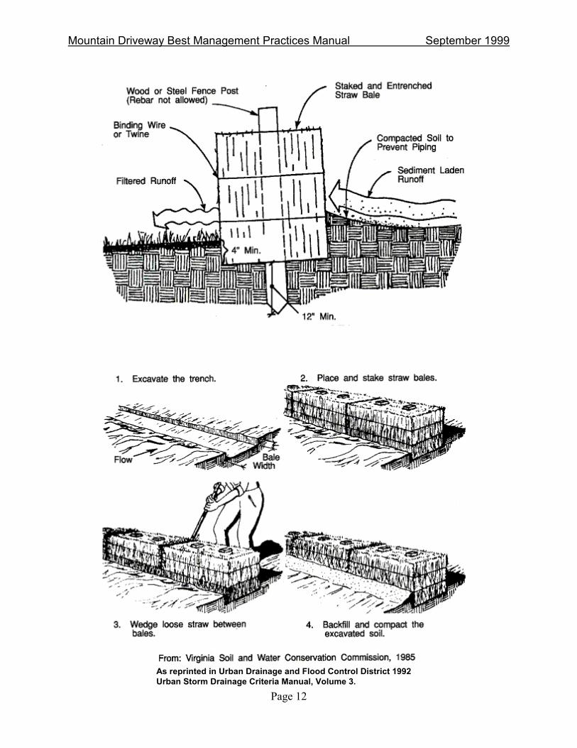
Straw Bales
Description
Straw bales can serve as a temporary sediment barrier when anchored across or at the toe of a slope to intercept and detain sediment and decrease flow velocities from small drainage areas. Some local governments discourage use of straw bales because of common failures associated with their use and encourage use of silt fence instead.
Installation/Design Guidelines
1. Use only in areas of low-velocity runoff where sheet and rill erosion potential is low to moderate. Excessive drainage area above bales can lead to failure.
2. Proper installation includes a) excavating a trench the width of the bale and length of the proposed barrier to a minimum depth of six inches; b) placing the bales in the trench; c) staking the bales by driving at least two wood stakes a minimum of six inches into the ground and towards the previously laid bale to force the bails together; and d) backfilling soil against the upgradient side of the hay bale.
3. �Chink� between bales with loose straw.
4. All bales must be either wire-bound or string-tied.
5. Straw bales should remain in place until vegetation is reestablished.
6. Use only weed-free bales, typically wheat straw rather than grass hay.
Special Considerations in Mountainous Areas
1. Thin, rocky soils may preclude the use of wooden stakes during installation.
2. If depth to bedrock is shallow, do not use this method.
3. Improved performance can be achieved by installing silt fence on the upslope side and placing it over the bales.
Maintenance
1. Remove excess sediment periodically, at a minimum when sediment reaches half of the straw bale height.
2. Repair or replace damaged bales and replace broken posts.
3. �Chink� between bales with loose straw.
4. Check weekly and after storms. Bales may only perform for a period of weeks or months. Check for rills under or around bales.
Type: Temporary
Mountain Driveway Best Management Practices Manual September 1999
Page 12
As reprinted in Urban Drainage and Flood Control District 1992 Urban Storm Drainage Criteria Manual, Volume 3.
Mountain Driveway Best Management Practices Manual September 1999
Page 13
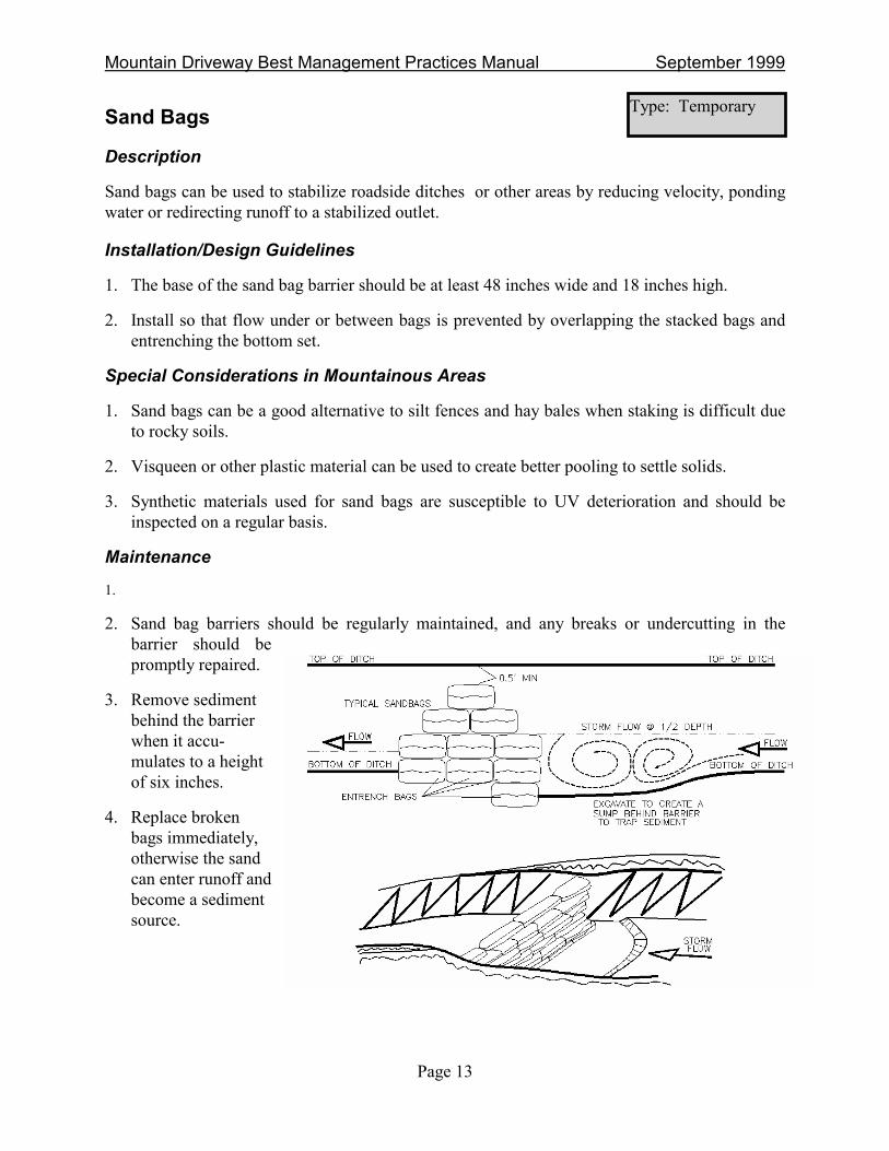
Sand Bags
Description
Sand bags can be used to stabilize roadside ditches or other areas by reducing velocity, ponding water or redirecting runoff to a stabilized outlet.
Installation/Design Guidelines
1. The base of the sand bag barrier should be at least 48 inches wide and 18 inches high.
2. Install so that flow under or between bags is prevented by overlapping the stacked bags and entrenching the bottom set.
Special Considerations in Mountainous Areas
1. Sand bags can be a good alternative to silt fences and hay bales when staking is difficult due to rocky soils.
2. Visqueen or other plastic material can be used to create better pooling to settle solids.
3. Synthetic materials used for sand bags are susceptible to UV deterioration and should be inspected on a regular basis.
Maintenance
1.
2. Sand bag barriers should be regularly maintained, and any breaks or undercutting in the barrier should be promptly repaired.
3. Remove sediment behind the barrier when it accu-mulates to a height of six inches.
4. Replace broken bags immediately, otherwise the sand can enter runoff and become a sediment source.
Type: Temporary

Mountain Driveway Best Management Practices Manual September 1999
Page 14
Silt Fence
Description
Silt fences are temporary barriers constructed of woven, synthetic material attached to posts. The goal of this BMP is to pool water from an eroding area, allowing the sediment to settle. Sediment transported off-site can otherwise collect in drainages, waterways, wetlands or adjacent properties.
Installation/Design Guidelines
1. Secure filter fabric to the ground by installing wooden posts to a depth of 12 inches and excavating a trench at least six inches deep along the line of the post and upslope from the barrier. Bury lower eight inches of filter fabric into this trench and compact the backfill soil.
2. Posts should be spaced a maximum of 10 feet apart. For shallow channel flow applications, the posts should be spaced a maximum of three feet apart and reinforced with wire mesh. The base of the fence should be secured.
3. Silt fences installed across swales must have the bottom of the ends of the fence at a higher elevation than the top center of the fence.
4. Silt fences should be installed along the contour at least five feet below the base of gentle slopes in areas where upgradient disturbance is occurring.
5. Silt fences should remain in place until vegetation has been established.
Special Considerations in Mountainous Areas
1. Thin, rocky soils may preclude the use of this BMP in mountainous areas.
2. In areas prone to rockfall, install a wire mesh fence uphill 10 feet to capture rocks that may damage the fence.
3. When equipment is working near sensitive areas or when substantial movement of fill is taking place, it may be necessary to reinforce the silt fence with wire mesh.
Maintenance
1. Inspect fences weekly and before and after storms. Silt fence may only perform for a period of weeks or months.
2. Look for rills under and around fences.
3. Remove excess sediment periodically, at a minimum when the sediment reaches one-fourth of the silt fence height.
4. Repair or replace damaged fence, and replace broken posts.
Remove silt fence when area has been successfully revegetated.
Type: Temporary

Mountain Driveway Best Management Practices Manual September 1999
Page 15
As reprinted in Urban Drainage and Flood Control District 1992 Urban Storm Drainage Criteria Manual, Volume 3.

Mountain Driveway Best Management Practices Manual September 1999
Page 16
Sediment Traps
Description
Sediment traps are temporary excavated basins or embankments which allow water to pool long enough for sediment to settle. The goal of sediment traps is to capture sediment from limited runoff areas. Sediment traps can be converted into permanent stormwater management structures.
Installation/Design Guidelines
1. Locate traps at points of discharge from disturbed areas prior to construction.
2. Install sediment traps either by excavating below grade or building an embankment across an intermittent swale. Excavated traps are less prone to failure. Never construct sediment traps on a live stream.
3. Shallow, rectangular traps, with a length-to-width ratio of 2:1 or greater, are the most efficient.
4. Outlet structures should consist of a trapezoidal weir protected from scour by a combination of coarse aggregate/riprap of 6-inch to 10-inch size to provide for filtering and energy dissipation. Place geotextiles below aggregate to reduce potential scouring of the outlet.
5. The outlet crest should be at least six inches to one foot below the top to the embankment.
6. Size to hold at least 1/4-inch of erosion from tributary land areas (900 cubic feet per acre).
7. Avoid embankments consisting of silt or clay and large cobbly soil. These typically fail if not protected with plastic or geotextile.
Special Considerations in Mountainous Areas
1. Sediment traps are easily adaptable to many conditions, including thin soils and steep slopes. The size of sediment traps can vary, making this BMP flexible.
2. Place the traps where they are most effective such as before pipes, in areas where slopes flatten, and where access is easy for maintenance.
3. Install a stick or post to indicate when trap is at appropriate level for sediment removal.
Maintenance
1. Maintain sediment traps on a regular basis; check sediment levels after storms and clean out once trap is half full of sediment.
2. Repair embankments as needed, and remove debris from outlets.
3. Dispose of sediment in stable locations where it will not be reintroduced to the system.
Type: Temporary

Mountain Driveway Best Management Practices Manual September 1999
Page 17
As reprinted in Urban Drainage and Flood Control District 1992 Urban Storm Drainage Criteria Manual, Volume 3.

Mountain Driveway Best Management Practices Manual September 1999
Page 18
Sediment Basins
Description
Sediment basins are used to detain runoff from an area and allow settling of sediment. Sediment basins include an outlet (usually a pipe) to control the outflow rate and can be designed for temporary or long-term use. With regard to mountain driveways, sediment basins would be appropriate for use as part of BMPs implemented for the overall site development.
Installation/Design Guidelines
1. Locate sediment basins in natural drainage areas but not on live streams or in wetlands. The lowest portion of the site is typically the most logical location for installation.
2. Install them early in the construction process, allowing the BMP to be utilized for the longest period possible.
3. Basins should be long and narrow (length twice as long as width) and relatively shallow in depth to provide maximum settling time.
4. Provide a stabilized outlet downstream.
5. Install an emergency spillway to protect the embankment.
Special Considerations in Mountainous Areas
1. Possible problems may occur due to thin or rocky soils unfavorable to excavating dirt or building embankments. Smaller sediment traps or check dams may be used in these cases.
2. Permanent sediment or detention basins may be necessary for subdivisions in a mountain area but are not necessary for single-family residences.
3. If over five acres of denuded land drains to an area, a sediment basin is generally appropriate.
Maintenance
1. Sediment should be removed when the basin is half full.
2. Check embankments for seepage and repair them as needed.
3. Check spillways for debris and remove as necessary.
4. Clean out and periodically maintain the outlet.
Type: Temporary or Permanent
As reprinted in Urban Drainage and Flood Control District 1992 Urban Storm Drainage Criteria Manual, Volume 3.

Mountain Driveway Best Management Practices Manual September 1999
Page 19
Brush Barriers
Description
Brush barriers are temporary sediment barriers composed of limbs, weeds, vines, root matter, soil, rock and other cleared material pushed together to form a berm to intercept and detain sediment and decrease flow velocities.
Installation/Design Guidelines
1. Locate across or at the toe of the slope.
2. The height of a brush barrier should be a minimum of three feet.
3. The width of a brush barrier should be a minimum of five feet at its base.
4. Securing the barrier with geotextile fabric will improve its effectiveness.
Special Considerations in Mountainous Areas
1. Use during timber removal activities as a way to pile limbs and catch sediments.
2. Upon completion of the project, the barrier material can be chipped and applied as mulch to reseeded areas.
3. Although typically only 30 percent effective, this measure can assist in removing a portion of the sediment load prior to runoff being passed through more effective downstream measures.
4. Always use this method in conjunction with other BMPs.
Maintenance
1. Remove loose sediment that is collected behind the berm.
2. Remove barriers when they have served their usefulness and chip debris and haul off site or use as mulch. Do not burn in place.
3. Revegetate the area after removal of the barrier.
Type: Temporary

Mountain Driveway Best Management Practices Manual September 1999
Page 20
Check Dams
Description
Check dams are small dams constructed across a drainage ditch or swale to reduce the velocity of concentrated flows. Reduced runoff velocity reduces erosion and gullying in the channel and allows sediment to settle.
Installation/Design Guidelines
1. Check dams should be installed in steeply sloped swales or in ditches where adequate vegetation cannot be established or as a temporary measure before ditches are stabilized.
2. A check dam can be built from logs, stone, or gravel-filled sand bags.
3. The maximum height of the check dam at the center should not exceed one-half the depth of the ditch or swale. The center of the dam should be at least six inches lower than the outer edges and convey flows without flowing around the dam.
4. Ensure that the maximum spacing between dams places the toe of the upstream dam at the same elevation as the top of the downstream dam.
Special Considerations in Mountainous Areas
1. Check dams can be used where it is not possible to divert the flow or otherwise stabilize the channel.
2. Check dams are appropriate where thin soils or shallow bedrock exists.
3. Do not use this method on a live stream.
4. Where needed, place on a foundation of filter fabric to avoid undercutting.
Maintenance
1. Remove sediment accumulated from behind the check dam when it has reached half the original dam height.
2. Erosion caused by high flows around the edges can be corrected by sandbags and should be corrected as soon as possible.
3. Temporary check dams should be removed when they are no longer useful.
Type: Temporary or Permanent

Mountain Driveway Best Management Practices Manual September 1999
Page 21

Mountain Driveway Best Management Practices Manual September 1999
Page 22
Vegetation Buffers
Description
Buffer strips are uniformly graded and densely vegetated areas of native grass. They require sheet flow to promote filtration, infiltration and settling to reduce runoff pollutants. Grass buffer strips differ from grass-lined swales because they are designed to accommodate overland sheet flow rather than concentrated or channelized flow. They can be used to remove sediment from sheet flow runoff from impervious areas and improve infiltration.
Installation/Design Guidelines
1. Concentrated runoff should be evenly distributed across the width of the buffer strip to achieve sheet-flow conditions as much as possible.
2. Buffer strips can be located adjacent to major drainageways and receiving waters and interspersed with shrubs and trees that can take up nutrients and provide shading.
3. Buffer strips should be sized to accommodate expected flow conditions.
Special Considerations in Mountainous Areas
1. Native, drought-tolerant, sod-forming grasses such as western wheatgrass and streambank wheatgrass should be used in buffer strips.
2. Ensure that the vegetative cover is dense enough to protect underlying soil while causing sediment to settle.
3. Overexcavate where soils may not be sufficiently permeable and replace with sand or gravel and cover with soil.
Maintenance
1. Periodically remove accumulated sediments.
2. Mow regularly to a minimum height of six inches to stimulate root growth and close the canopy.
3. Obtain proper fertilizer recommendations on a maximum five-year cycle.
4. Repair any rills that form.
Type: Permanent

Mountain Driveway Best Management Practices Manual September 1999
Page 23

Mountain Driveway Best Management Practices Manual September 1999
Page 24
Grass-lined Swales
Description
Grass-lined swales are densely vegetated small drainageways with low-pitched side slopes that collect and slowly convey runoff. Design of their longitudinal slope and cross-section size forces the flow to be slow and shallow, thereby facilitating sedimentation while limiting erosion.
Installation/Design Guidelines
1. Roadside swales should be designed to convey concentrated surface runoff to a receiving channel without damage from erosion.
2. Berms or check dams should be installed within the swale perpendicular to the flow as needed to slow it down and to encourage settling and infiltration.
3. Channel cross-section and lining should be considered based upon volume and velocity of expected flow. Possible cross-section shapes include �V�-shaped (low water), parabolic (high water, low velocity) or trapezoidal (high water, high velocity).
4. Establishing dense, resistant, sod-forming vegetation is essential. Erosion control blankets may be needed following seeding until vegetation is established.
5. Stabilize the outlet.
Special Considerations in Mountainous Areas
1. Grass may be difficult to establish and maintain in arid and cold areas. Riprap can be used to stabilize roadside ditches in place of vegetation, although the cost is much higher. Erosion matting can provide stability until vegetation is established.
2. Grass swales are not appropriate for steep slopes or high velocity drainages.
3. Avoid sharp changes in direction or grade.
Maintenance
1. Mow no closer than six inches, and preferably taller, to increase filtering ability.
2. Wider, flatter, shallower ditches are easier to maintain.
3. Maintain center line ditch grade to be between one and two feet below the edge of roadway.
4. Keep the grass in healthy condition at all times, since it is the primary erosion protection and filtration media for the swale.
Type: Permanent

Mountain Driveway Best Management Practices Manual September 1999
Page 25
As reprinted in Urban Drainage and Flood Control District 1992 Urban Storm Drainage Criteria Manual, Volume 3.

Mountain Driveway Best Management Practices Manual September 1999
Page 26
Revegetation
Description
Revegetation is the establishment of vegetative cover on soil left bare by the construction process. This process includes seedbed preparation, temporary revegetation and permanent revegetation with mulching. Revegetation limits erosion and sedimentation on areas adjacent to the driveway by preventing raindrop and sheet flow erosion and weed infestation of exposed earth.
Installation/Design Guidelines
1. Use native vegetation recommended in your area. A representative list of commonly used native seed mixes in Colorado is provided in Appendix 1.
2. Check weights, seed species and purities prior to planting the seed.
3. Prior to permanent seeding, prepare soil (e.g., roughen soil surface) and incorporate topsoil, amendments and fertilizer as needed. Use stock-piled topsoil, if possible. Cover seeds to proper depth (e.g., 1/4 to 3/8 inches). Use fertilizer sparingly.
4. Apply mulch after seeding to retain moisture and protect from erosion.
Special Considerations in Mountainous Areas
1. Timing, soil type, fertilization requirements and availability of irrigation supply are all serious considerations prior to selecting a method of revegetation. Conduct soil tests and consult local experts as needed.
2. Steeper slopes require more attention to revegetate. Mulch should be used on slopes steeper than 3:1 and matting or hydromulch should be used on slopes steeper than 2:1.
3. Native grasses can become established without irrigation in most circumstances.
Maintenance
1. Check for growth and re-seed areas where the coverage is not complete. Vegetation is considered established when ground cover is achieved which is sufficiently mature to control soil erosion (approximately 80 percent coverage) and can survive severe weather conditions.
2. Watering should be performed as needed during the first year of installation in the absence of rainfall.
Type: Permanent
Adapted from McCullah 1994.

Mountain Driveway Best Management Practices Manual September 1999
Page 27
Mulching
Description
Mulching is the application of plant residue or other suitable biodegradable material to the soil surface. The goal of this BMP is to protect the soil surface, reducing raindrop impact erosion, which in turn reduces sheet flow, rill, gully and channel erosion by increasing infiltration. Mulch also facilitates the growth of vegetation by increasing available moisture, providing insulation against extreme heat and cold and shading seeds from intense sun. Mulch also reduces wind erosion.
Installation/Design Guidelines
1. To be effective, mulch must be attached to the ground by chemical tackifiers or mechanical crimping.
2. Wheat straw should consist of native grasses free of noxious weeds and seeds. Use native grass hay where practical. Avoid smooth bromegrass hay.
3. Straw or hay mulch should be long-stemmed and spread at a rate of one and a half to two tons per acre.
4. Applied mulch depth should be between one to two inches.
5. Mulch should be applied immediately after seeding.
Special Considerations in Mountainous Areas
1. Mulch retains moisture, which helps to minimize water requirements for revegetation.
2. Mulch requires no removal because of natural decomposition.
3. Mulch can be blown away in areas exposed to high winds, so crimping is necessary. Blown on and unattached mulch is typically less than 30 percent effective.
Maintenance
1. Inspect mulch periodically, especially after wind and rainstorms.
2. Reapply additional mulch as necessary with the appropriate seed mix in bare and unproductive spots.
3. Spot apply weed killers to noxious weeds.
4. Mulch is not very effective on slopes steeper than 3:1. Erosion mats are a better alternative in such case.
Type: Temporary

Mountain Driveway Best Management Practices Manual September 1999
Page 28
Erosion Control Blankets
Description
Erosion control blankets and mats are strong, man-made mattings used to stabilize channels, swales and newly-planted slopes. The type and weight of these measures differ depending on slope and soil. Erosion control blankets can be used in place of mulch on areas of high velocity runoff and/or steep grade to aid in controlling erosion on critical areas and revegetation.
Installation/Design Guidelines
1. Use erosion control blankets where vegetation is likely to grow too slowly to provide adequate cover, in areas susceptible to rilling, and in areas subject to high winds where mulch would not be effective.
2. Smooth the ground and remove any material larger than three inches in diameter prior to application.
3. Install erosion control blankets parallel to the direction of the slope and overlap the uphill section over the downhill section.
4. In ditches, apply erosion control blankets in the direction of the flow.
5. Place erosion control blankets loosely on soil; do not stretch them.
6. The edges of the blanketed area should be anchored and buried no less than six inches deep.
7. Staple the blanket at least every three feet.
8. Always follow the manufacturer�s instructions for installation.
9. Apply seed, fertilizer and mulch prior to laying blankets.
Special Considerations in Mountainous Areas
1. Use erosion control blankets to stabilize steep slopes, particularly where vegetation is difficult to establish and winds will remove mulch. Select staples consistent with soil depth.
2. Where possible, irrigate the mat areas by sprinkler the first season to promote revegetation. Do not overwater slopes where slippage can occur and erosion can begin.
Maintenance
1. Check for erosion and undermining periodically, particularly after storms, and monitor until permanently stabilized with vegetation.
2. Repair dislocations or failures immediately.
3. If washouts occur, reinstall erosion control blankets after repairing slope damage and reseeding.
Type: Temporary

Mountain Driveway Best Management Practices Manual September 1999
Page 29
From: Virginia Soil and Water Conservation Commission, 1985
As reprinted in Urban Drainage and Flood Control District 1992 Urban Storm Drainage Criteria Manual, Volume 3.

Mountain Driveway Best Management Practices Manual September 1999
Page 30
Slope Stabilization
Description
Fill slopes, some cut slopes and spoil disposal areas will require vegetative and/or mechanical measures to ensure stable slopes, depending on factors such as slope angle, soil type, aspect and climate. Vegetative measures can include seeding, sodding and/or planting trees and bushes. Mechanical measures may include surface roughening, wattling, erosion mats/nets, terraces, side drains, riprapping, mulch, tackifiers, soil seals, soil cement and retaining walls.
Installation/Design Guidelines
1. Obtain accurate soils and geologic information on which to base maximum cut and fill slopes to handle surface and subsurface drainage.
2. Run on from off-site, runoff from the site and stream flow should be controlled so they do not reach and overtop the face of any slope subject to failure or significant erosion.
3. Concentrated flows should be discharged to a stable drainage conveyance system or be dissipated into natural forest areas.
4. Uninterrupted slope lengths should be limited. Limit continuous runs downhill to less than 50 linear feet and install waterbars, trenches, etc., to break up runs.
5. Where cuts or other excavations intercept groundwater, subsurface drainage systems should be installed. Water collected in these systems should be discharged to stable drainage systems. If possible, do not commingle this water with stormwater, which would increase volume and velocity of flow in ditches and swales.
6. Facilities conveying runoff down slopes should be designed for a 10-year storm or, at a minimum, one inch of runoff over the drainage area.
Special Considerations in Mountainous Areas
1. Stabilize slopes prior to the first winter season, when erosion is most severe.
2. Vegetation may take several seasons to become densely established and effective.
3. Where possible, slopes should be sloped back at a 3:1 ratio or flatter. (If slopes are steeper or sloughing is of concern, structural measures like retaining walls, concrete, etc., will be needed.) Check local government requirements for slope restrictions.
Maintenance
1. Slope stabilization features should be inspected and repaired as needed, especially after spring snowmelt and major storms.
2. Failures generally indicate selected method is inadequate. Rather than repairing, rebuilding or reapplying the same BMP, install an alternative, more protective method.
Type: Permanent

Mountain Driveway Best Management Practices Manual September 1999
Page 31
Slope Drains
Description
Slope drains are flexible or rigid conduits that extend from the top to the bottom of a cut or fill slope. The goal of this BMP is to carry stormwater runoff to a stabilized outlet to avoid erosion.
Installation/Design Guidelines
1. Slope drains should consist of heavy duty material designed and suitable for the purpose.
2. All drain sections should be securely fastened together, have water-tight fittings, and be securely anchored to the slope.
3. The minimum pipe size for slope drains should be eight inches.
4. Soil around and under inlets should be compacted.
5. The inlet and outlet of the drain should be protected with rock to prevent erosion.
6. Do not use perforated or slotted pipe sections in this application.
7. Extend the downstream end of the pipe 15 feet beyond the toe of slope before daylighting to avoid wetting the toe of slope.
8. If buried, install cleanouts at 50 feet minimum and 100 feet maximum intervals to facilitate cleanout.
Special Considerations in Mountainous Areas
1. Proper installation is very important because failure of slope drains often results in severe gully erosion on the site and sedimentation below the slope.
Maintenance
1. Replace sections that are crimped or crushed.
2. Inspect for bypass of inlet and modify to keep 95 percent of available runoff in system and not overland.
3. Maintain ditches that run to slope drains because they can be significant sources of sediment loading.
4. Leave slope drain in place until two years after revegetation reaches 70 percent cover to ensure that the slope is stable and roots are well established.
Type: Temporary or Permanent

Mountain Driveway Best Management Practices Manual September 1999
Page 32
As reprinted in Urban Drainage and Flood Control District 1992 Urban Storm Drainage Criteria Manual, Volume 3.

Mountain Driveway Best Management Practices Manual September 1999
Page 33
Road Drainage
Description
Proper control of road drainage is one of the most important BMPs for minimizing erosion and sedimentation in mountainous areas. A variety of approaches can be used including controlling road slopes, providing drainage dips, wing ditches, culverts, cross drainage and other measures.
Installation/Design Guidelines
1. Use crowning, outsloping, ditches, and/or culverts to drain roads.
2. Install ditches, culverts, cross drainage and wing ditches at low points in the road.
3. Provide outfall protection for cross drains, culverts and wing ditches.
4. Use diversion or wing ditches wherever possible to carry road drainage into undisturbed, stable, vegetated areas.
5. Avoid insloping and inside ditches whenever possible. (A possible exception is curves located in fill areas.) In-sloping ditches will require a culvert to transfer flow to an outside ditch or directly to the hillslope.
6. Use adequately sized culverts to carry the anticipated flow of water.
7. Water bars or rolling dips may also be installed periodically along the driveway to reduce drainage velocity and associated erosion.
Special Considerations in Mountainous Areas
1. Identify culverts with posts or poles so they can be cleared of ice and debris in winter.
2. Proper road drainage design should decrease future maintenance costs associated with erosion.
3. Where practical, locate roads to receive southern exposure to facilitate melting of ice and snow and keep the road drier.
Maintenance
1. Maintain road crown and water bars to drain surface.
2. Maintain ditch line to drain properly.
3. Clean out culverts periodically.
4. Inspect and maintain culvert and ditch outfalls after runoff events to ensure concentrated flow has not damaged hillslope stability.
Type: Permanent

Mountain Driveway Best Management Practices Manual September 1999
Page 34
Road Drainage Tips: US Forest Service Recommendations for Culvert & Waterbar Spacing
Road Grade (%) Culvert Spacing (feet)
0-4 1,000 5-6 840 7-8 600
9-10 460 11-12 380 13-14 320 15-16 280 17-18 250
Water Bar Spacing (Feet ) Depending on
Road Grade and Soil Type Soil Type
Road Grade (%) Granitic or Sandy Shale or Gravel Clay 2 900 1,000 1,000 4 600 1,000 800 6 500 1,000 600 8 400 900 500
10 300 800 400 12 200 700 400 15 150 500 300 20 150 300 200
25+ 100 200 150
Notes: Road grades provided are assumed to be the average sustained grade for distances shown. Distances are approximate and should be varied to take advantage of natural features.
Source: Colorado State University Cooperative Extension, 1994. Foresters Field Handbook. Compiled and edited by Steve Larrabee, Jim Rassman, and Dennis Lynch. Publication XCM-185.

Mountain Driveway Best Management Practices Manual September 1999
Page 35

Mountain Driveway Best Management Practices Manual September 1999
Page 36
Drainageway Protection
Description
The goal of this BMP is to prevent sediment from entering storm drainage systems, drainageways and sensitive environments prior to permanent stabilization of disturbed areas. Drainageway and inlet protection measures may also be used during winter road maintenance practices which involve sanding and salting.
Installation/Design Guidelines
1. Use temporary stream diversions to route water from upslope areas around construction activities taking place within a waterway.
2. Construct a barrier around storm drain inlets during construction using silt fence, gravel bags, or other materials protected to prevent sediment-laden runoff from entering the conveyance system without first being ponded or otherwise treated to remove sediment.
3. Grade roadside ditches with a slight rise (± 6 inches high) downstream of culvert inlets to direct flow into the culvert.
4. Install stable outlets from storm drainage systems.
Special Considerations in Mountain Areas
1. Drainageway protection measures are particularly important in mountain areas because construction activities often take place near sensitive receiving waters (e.g., trout streams).
2. Mark inlets with stakes or poles so they can be cleaned out during winter.
Maintenance
1. Frequently inspect BMPs implemented for drainageway protection, particularly after storms.
2. Inspect storm drain inlet protection structures before and after each storm event to repair and remove accumulated sediment.
3. Perform maintenance prior to seasonally high flow.
Type: Temporary

Mountain Driveway Best Management Practices Manual September 1999
Page 37
Outlet Protection
Description
Outlet protection involves reducing flow velocities and sediment scour at stormwater outlets or otherwise protecting receiving channels. Representative measures include riprapping or paving channel sections or installing stilling basins.
Installation/Design Guidelines
1. The grade of the stormwater outlet or apron should be zero percent.
2. The apron may be lined with grouted riprap, concrete, or asphalt.
3. A geotextile or granular filter should always be included and placed between the apron and underlying soil.
4. Geotextiles should be protected from puncture, cuts and tearing during construction.
5. Never use less than a 15-inch collar to facilitate cleaning.
Special Considerations in Mountainous Areas
1. Protecting outlets to minimize erosion and sediment contribution to streams is a particularly important consideration for sensitive streams containing cold water fisheries (e.g., trout).
Maintenance
1. Inspection should be performed after high flows for scour and dislodged stones.
2. Straighten culvert ends that are crushed or crimped.
Type: Permanent

Mountain Driveway Best Management Practices Manual September 1999
Page 38
Infiltration Practices Description
Infiltration practices include measures to percolate runoff into soils. Typical practices include rock-filled trenches or basins (dry wells). Infiltration is highly dependent on subsoil permeability; therefore, use of this BMP will have limited application in mountain areas.
Installation/Design Guidelines
1. The size of the infiltration system depends on soil permeability and runoff area. The system should be able to infiltrate one inch precipitation per hour.
2. A pre-sedimentation device is necessary for infiltration systems to avoid clogging.
3. Don�t build infiltration trenches where tributary slopes are steeper than 15%. When a slope of 15% is exceeded, convey the runoff to a dry well or lateral infiltration trench located along a slope contour.
4. Grade the driveway with a 1-5% slope toward the trench. Install the trench along the low side of the driveway with a minimum width of 18 inches and a minimum depth of three feet.
5. For steep driveway slopes, install a paved ditch or french drain along the low side of the driveway and route the runoff to lateral infiltration trenches located along slope contours or to a dry well located in more level areas. Install a water bar between each section of ditch to prevent runoff from continuing downslope.
6. Do not locate a driveway on top of an infiltration trench. Avoid placing trenches where their construction will damage tree roots, cause hillslope failure, damage concrete foundations or where subsoil or bedrock conditions are not conducive to groundwater movement.
Special Considerations in Mountainous Areas
1. Do not install lateral infiltration trenches on unstable slopes or fill slopes steeper than 4:1.
2. Infiltration practices may not be appropriate in mountain areas with shallow soils where bedrock is close to the surface.
Maintenance
1. Clean out accumulated sediment and debris when the systems fails to infiltrate storm runoff.
2. If rapid clogging occurs and pre-sedimentation BMPs cannot be placed upstream, discontinue infiltration and install surface-maintained BMPs.
Type: Permanent

Mountain Driveway Best Management Practices Manual September 1999
Page 39
Stream Crossings Description
Stream crossings associated with mountain driveways are typically either culverts or bridges. Proper stream crossing design is important to minimize adverse impacts to the stream and man-made structures.
Installation/Design Guidelines
1. Consult with the U.S. Army Corps of Engineers to determine the appropriate Clean Water Act 404 permit necessary prior to construction, in addition to checking local requirements.
2. Design stream crossings to allow adequate passage of fish, to reduce impacts on water quality and to handle peak runoff and flood waters for the 25-year storm at a minimum.
3. Cross streams at right angles to the main channel whenever possible; angled crossings often fail.
4. Adequately size culverts. A minimum of 18-inch diameter with two feet of cover is recommended.
5. Adjust the road grade to drain runoff from it upstream of the stream crossing.
6. Direct roadside ditch flows away from stream crossings to stabilized vegetated areas.
7. On live streams, always consult with your local floodplain manager prior to construction to determine if the planned crossing is located in a 100-year regulatory floodplain.
8. Construct crossing out of erosion-resistant materials such as concrete, asphalt and compacted soil materials.
Special Considerations in Mountainous Areas
1. Phase timing of construction during low flows to protect fisheries and water quality.
2. Consult with a professional engineer prior to instream work.
3. Select crossing location carefully in the context of stream hydraulics�a flat and stable reach is preferable to a riffle location.
4. Unimproved stream crossings are not recommended where permanent/daily access is needed.
5. Provide a plunge pool on downstream side of crossing to aid in dispersing energy and avoid undercutting of embankment.
Maintenance
1. Keep stream crossing openings (e.g., culverts) free of debris.
2. Fortify banks upstream of a bridge or culvert and on the side slopes of a driveway embankment crossing to minimize a culvert washout during a high flow event or season.
Type: Temporary or Permanent

Mountain Driveway Best Management Practices Manual September 1999
Page 40
As reprinted in Urban Drainage and Flood Control District 1992 Urban Storm Drainage Criteria Manual, Volume 3.

Mountain Driveway Best Management Practices Manual September 1999
Page 41
Source Controls
Description
Pollutant source controls include construction staging, good housekeeping, and proper storage of fuel and chemicals. Materials are sometimes used at construction sites that present a potential for contamination of stormwater runoff. These include fuel, oil, lubricants, paints, solvents, concrete-curing compounds and other liquid chemicals such as fertilizers, herbicides and pesticides. Source controls should be applied to overall site development including both the building site and the driveway.
Installation/Design Guidelines
1. Designate an area for storage of toxic materials and petroleum products at least 100 feet away from water bodies.
2. Know and comply with regulations governing the storage, handling, application and disposal of toxic and hazardous substances.
3. Areas at the construction site used for storage of toxic materials and petroleum products should be designed with an enclosure, container, or dike located around the perimeter of the storage area to prevent discharge of these materials in runoff from the construction site. These barriers will also function to contain spilled materials.
4. Areas used for collection and temporary storage of solid or liquid waste should be designed to prevent discharge of these materials in runoff from the construction site. Collection sites should be located away from the storm drainage system and sensitive riparian areas.
5. Consideration should be given to covering waste storage areas, to containing windblown materials and to constructing a perimeter dike to exclude runoff.
6. Use drip pans as needed under construction equipment.
Special Considerations in Mountainous Areas
1. Construction areas in the mountains are frequently located near sensitive receiving waters (e.g., trout streams); therefore, special care should be taken to prevent spills and leaks from reaching these waters.
2. Toxic materials, such as wood preservatives and some road surface treatments, should be carefully considered and managed when used near streams. Non-toxic product alternatives should be used when feasible.
Maintenance
1. Inspect construction staging and materials storage areas on a daily basis for spills and leaks and clean these up as soon as possible.
Type: Temporary or Permanent

Mountain Driveway Best Management Practices Manual September 1999
Page 42
Winter Maintenance: Sanding and Snow Removal
Description
Winter road maintenance including snow removal and sanding are necessary for safe and efficient use of driveways. However, plowed snow can contain residual amounts of petroleum products, salt and sediment which can adversely impact water quality. Several guidelines can be followed to minimize adverse impacts of winter maintenance as described below.
Installation/Design Guidelines
1. Do not dump or plow snow into or adjacent to stream channels, storm drains or other drainageways.
2. Create a snow storage area which promotes infiltration and evaporation to minimize contaminated snowmelt reaching stream channels.
3. Use the minimum amount of sand with the lowest possible salt content needed to enable safe use of the driveway.
4. Store sand and salt under cover or shelter to prevent washing away.
Special Considerations in Mountainous Areas
1. Check local government regulations for specific requirements for snow removal.
2. Design sedimentation facilities (e.g., traps) adjacent to driveways and parking areas to capture gravel and sand.
Maintenance
1. Remove accumulated sediment and debris as soon as possible. This may involve sweeping sand after storms.
2. Consider reuse of captured materials if sediment fines content is low.
3. Repair roadside vegetation and ditches damaged by accumulation of de-icing materials.
Type: Permanent

Mountain Driveway Best Management Practices Manual September 1999
Page 43
References For More Information
For more information on BMPs appropriate to your area, the following resources and references may provide additional guidance:
Best, Virgil, 1998. �Summit County Native Revegetation Seed Recommendation.� (can be obtained from the Summit County Community Development Division).
Boulder County Land Use Department, 1998. Miscellaneous Publications on BMPs
Colorado Department of Transportation, 1995. Erosion and Sediment Control Pocketbook.
Colorado Native Plant Society Horticulture and Restoration Committee (undated). Suggested Native Plants for Horticultural Use in Northeastern Colorado.
Colorado State Forest Service, 1998. �Colorado Forest Stewardship Guidelines to Protect Water Quality-Best Management Practices for Colorado.�
Denver Regional Council of Governments Urban Drainage and Flood Control District and Colorado Department of Transportation, 1998. Keeping Soil On Site Construction Management Practices. February.
Fort Collins Soil Conservation District, Big Thompson Soil Conservation District, USDA Soil Conservation Service (undated). Living in Rural Larimer County �An Owner�s Manual.�
Larimer County, 1998. Brochure for Rural Road Construction.
Salix Applied Earthcare, 1994. Erosion Draw 2.0 Software and Erosion and Sediment Control Manual for Computer Aided Drafting. Drawings 1994 by John McCullah.
United States Department of Agriculture (USDA) Forest Service and Soil Conservation Service, 1992. Building Water Pollution Control Into Small Forest and Ranchland Roads.
Urban Drainage and Flood Control District, Denver, CO. Urban Storm Drainage Criteria Manual, Volume 3. September 1992.
USDA Forest Service and Soil Conservation Service, 1991. Woods Roads: A Guide to Planning and Constructing A Forest Roads System.
USDA Forest Service, 1992. Winter Sports Guidebook, June.
USDA Forest Service, 1996. Managing Roads for Wet Meadow Ecosystem Recovery. FHWA-FLP-96-016.
F:\BMP Manuals\Mtn Driveways\mountain driveways.doc September 8, 1999
Mountain Driveway Best Management Practices Manual September 1999
Page 44
Appendix 1
Representative Seed Mixes for Revegetation in Mountainous Areas Examples Included for Northeastern Colorado, Boulder County,
Larimer County, Summit County and Denver Front Range Foothill and Montane Zones
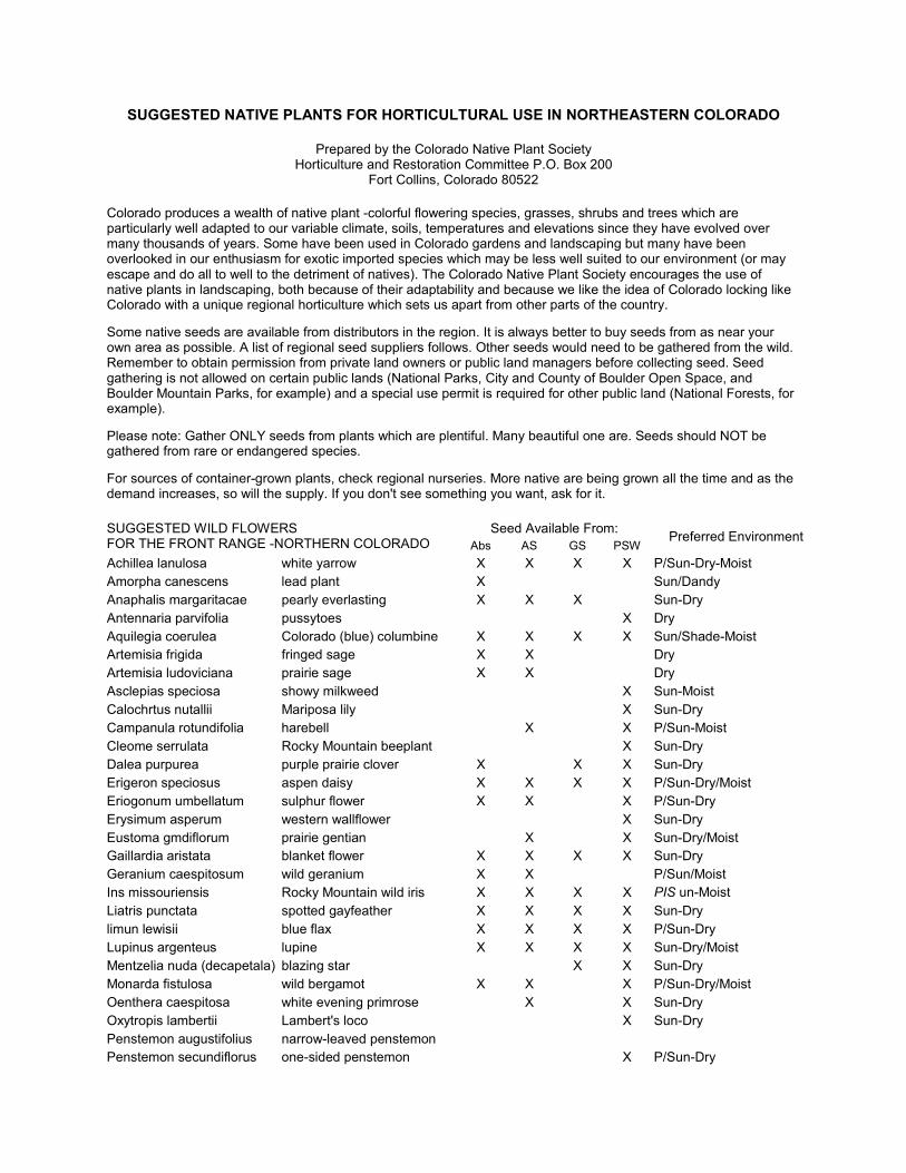
SUGGESTED NATIVE PLANTS FOR HORTICULTURAL USE IN NORTHEASTERN COLORADO
Prepared by the Colorado Native Plant Society Horticulture and Restoration Committee P.O. Box 200
Fort Collins, Colorado 80522
Colorado produces a wealth of native plant -colorful flowering species, grasses, shrubs and trees which are particularly well adapted to our variable climate, soils, temperatures and elevations since they have evolved over many thousands of years. Some have been used in Colorado gardens and landscaping but many have been overlooked in our enthusiasm for exotic imported species which may be less well suited to our environment (or may escape and do all to well to the detriment of natives). The Colorado Native Plant Society encourages the use of native plants in landscaping, both because of their adaptability and because we like the idea of Colorado locking like Colorado with a unique regional horticulture which sets us apart from other parts of the country.
Some native seeds are available from distributors in the region. It is always better to buy seeds from as near your own area as possible. A list of regional seed suppliers follows. Other seeds would need to be gathered from the wild. Remember to obtain permission from private land owners or public land managers before collecting seed. Seed gathering is not allowed on certain public lands (National Parks, City and County of Boulder Open Space, and Boulder Mountain Parks, for example) and a special use permit is required for other public land (National Forests, for example).
Please note: Gather ONLY seeds from plants which are plentiful. Many beautiful one are. Seeds should NOT be gathered from rare or endangered species.
For sources of container-grown plants, check regional nurseries. More native are being grown all the time and as the demand increases, so will the supply. If you don't see something you want, ask for it.
Seed Available From: SUGGESTED WILD FLOWERS FOR THE FRONT RANGE -NORTHERN COLORADO Abs AS GS PSW
Preferred Environment
Achillea lanulosa white yarrow X X X X P/Sun-Dry-Moist Amorpha canescens lead plant X Sun/Dandy Anaphalis margaritacae pearly everlasting X X X Sun-Dry Antennaria parvifolia pussytoes X Dry Aquilegia coerulea Colorado (blue) columbine X X X X Sun/Shade-Moist Artemisia frigida fringed sage X X Dry Artemisia ludoviciana prairie sage X X Dry Asclepias speciosa showy milkweed X Sun-Moist Calochrtus nutallii Mariposa lily X Sun-Dry Campanula rotundifolia harebell X X P/Sun-Moist Cleome serrulata Rocky Mountain beeplant X Sun-Dry Dalea purpurea purple prairie clover X X X Sun-Dry Erigeron speciosus aspen daisy X X X X P/Sun-Dry/Moist Eriogonum umbellatum sulphur flower X X X P/Sun-Dry Erysimum asperum western wallflower X Sun-Dry Eustoma gmdiflorum prairie gentian X X Sun-Dry/Moist Gaillardia aristata blanket flower X X X X Sun-Dry Geranium caespitosum wild geranium X X P/Sun/Moist Ins missouriensis Rocky Mountain wild iris X X X X PIS un-Moist Liatris punctata spotted gayfeather X X X X Sun-Dry limun lewisii blue flax X X X X P/Sun-Dry Lupinus argenteus lupine X X X X Sun-Dry/Moist Mentzelia nuda (decapetala) blazing star X X Sun-Dry Monarda fistulosa wild bergamot X X X P/Sun-Dry/Moist Oenthera caespitosa white evening primrose X X Sun-Dry Oxytropis lambertii Lambert's loco X Sun-Dry Penstemon augustifolius narrow-leaved penstemon Penstemon secundiflorus one-sided penstemon X P/Sun-Dry

Seed Available From: SUGGESTED WILD FLOWERS FOR THE FRONT RANGE -NORTHERN COLORADO Abs AS GS PSW
Preferred Environment
Penstemon stridus Rocky Mountain penstemon X P/Sun-Dry/moist Penstemon virgatus Ratibida colunmifera prairie coneflower X X X X P/Sun-Dry Rudbeckia hirta black-eyed susan X X X X P/Sun-Moist Solidago missouriensis goldenrod X Sun-Dry/moist Sphaaaicea coccinea scarlet globe mallow X X Sun-Dry Thermopsis montana golden banner X X X P/Sun-Moist Verbena bipinnatifida wild verbena X Sun-Dry
Seed not available from commercial suppliers in the area. Wild seed would have to be gathered.
Agaloma marginata snow-on-the-mountain Argemone polyanthemos prickly poppy Asdepias incamata swamp milkweed Astragalus bisculcatus two-grooved milkvetdl Astragalus missouriensis Missouri milkvetdl Delphinium nelsonii Nelson's larkspur Gutierrezia sarothrae broom snakeweed Helianthus pumilus bush sunflower Heterotheca fulerata golden aster Hymenoxys acaulis Madlaeranthera panersonii tansy aster Madlaeranthera pinnatifida spiny goldenweed Oenothera bradlycarpa yellow stemless evening primrose Opuntia compressa prickly pear Opuntia polyacantha prickly pear Oxytropis sericea Rocky Mountain loco Penstemon virens greenleaf penstemon Penstemon spp Pensternon (several native species) Phacelia sericea purple fringe flower Scutellana brittonii skullcap Senecio plattensis Senecio spartioides butterweed or golden ragwort Tradescantia occidentalis prairie spiderwort Verbena ambrosifolia wild begonia Verbena nastata blue vervain
SUGGESTED NATIVE SMALL/MEDIUM SHRUBS FOR THE FRONT RANGE -NORTHERN COLORADO
Amorphia canescens leadpaint Arnorphia fruticosa fasle indigo Mostaphylos uva-ursi kinnikinick Atriplex canescens four-winged saltbush Ceanothus fedieri Fendier ceanothus or buchbush Ceratoides lanata winterfat Cercocarpus montanus mountain mahogany Chrysothamnus nauseosus golden rabbitbrush Cornus stolonifera red osier dogwood Jamesia americana waxflower Juniperus communis common juniper Mahonia repens creeping Oregon grape

Physocarpus monogynus mountain ninebark Potentilla fruticosa shrubby cinquefoil Purshia tridentata antelope bitterbrush Rhus trilobata three-leaved sumac or skunkbush Ribes americanum American black current Ribes aureum golden current Ribes cereum wax current or squaw current Rubus deliciosus Boulder raspberry Rosa woodsii wild rose or Woods' rose Sambucus canadensis elderberry Sambucus racemosa red berried elderberry Symphoricarpos albus snowberry Yucca glauca narrow-leaf or plains yucca
SUGGESTED NATIVE LARGE SHRUBS/SMALL TREES FOR THE FRONT RANGE-NORTHERN COLORADO
Acer glabrum Rocky Mountain maple Acernegundo boxelder Alnus tenuifolia thinleaf alder Amelanchier alnifolia serviceberry Betula fontinalis river birch Celtis reticulata netleaf hackberry Crataigus succulenta western hawthorne Juniperus scopulorum Rocky Mountain juniper Prunus americana wild or American plum Prunus virginiana chokecheny Prunus besseyi sand cherry . Rhus glabra smooth sumac Sorb us scopulina mountain ash Shepherdia argentea Silver buffaloberry Shepherdia canadensis buffaloberry
SUGGESTED NATIVE GRASSES FOR COLORADO HEIGHT PREFERRED ENVIRONMENT Agropyron dasystachyum thickspike wheatgrass 15-30* Sandy, 5000-10000' Agropyron smithii western wheatgrass 15-30" Moist or dry, loam or day, 3500-10000' Agropyron spicatum Bluebunch wheatgrass 25-40" Dry, open woods Andropogon gerardii big bluestem 40-80" Prairies, foothills, 3500-6500' Andropogon hallii sand blustem 40-60' Plains, sand hills. 3500-5200' Andropogon scoparium little blustem 20-60" Prairies, foothills Bouteloua curtipendula sideoats grama 20-30" Prairies, rocky hills, 3500-7500' Bouteloua gracilis blue grama 10-20" Plains, foothills, 3500-9000' Buchloe dactyloides Buffalo grass 4-6" Dry plains, 3500-6000' Caiamovilfa longifolia prairie sandreed 20-70" Sandy prairies. hills, 3500-7000' Oanthonia parry Pany oatgrass 10-25" Mountains. 6000-10000' Oeschampsia caespitosa tufted hairgrass 30-50" Mountain meadows, 7000-10000' Oistichhs spicata stricta inland saltgrass 5-15" Alkaline, boggy 3500-9000' Elymus canadensis Canada wildrye 40-60" Plains, foothills, 3500-9000' Festuca arizonica Arizona fescue 15-40" . Mountains. 6000-1000' Koelena cristata (macrantha) Junegrass 15-25" Prairies, foothills to subalpine, 3500-10000' Lycurus phleoides wolftail 10-25" Plains, rocky hills, 4000-8000'

Muhienbergia asperifolia scratchgrass 5-20" Alkaline, moist, 3500-8000' Muhlenbergia cuspidata Stonehill muhly 10-15" Prairies, stony slopes, 5000-6000' Muhlengergia montana mountain muhly 10-25" Foothills, lower mountains, 5600-10000' Muhlenbergia wrightii spike muhly 10-25" Plains, open slopes, 5000-8000' Qryzopsis hymenoides Indian ricegrass 15-25" Sandy plans, mesas, 3500-9500' Panicum virgatum switd1grass 40-80" Marshes, prairies, foothills, 3500-7000' Poa canbyl Canby blugrass 20-50" Dry, sandy, 4500-9000' Poa sandbergii (secunda) Sandberg bluegrass 10-25" Dry plains, rocky slopes, 4500-12000' Pucinellia nuttallii alkaligrass 15-25" Moist, alkaline, 4500-9000' Redfieldia flexulosa blowout grass 25-40" Sand hills, 3500-8000' Sorgastrum nutans Indian grass 40-100" Sand hills, rocky foothills, 3500-6800' Spartina pectinata prairie cordgrass 40-80" Marshes, wet meadows, 3500-7000' Sporoboius airoides alkali sacaton 20-40" Damp.. alkaline, 3500-8000' Sporobolus cryptandrus sand dropseed 15-40" Sandy or loam, 3500-8000' Sporobolus heteroiepsis prairie dropseed 15-30" Prairies, foothills, 5000-7200' Stipa comata needle-and thread 15-25" Plains, dry hills, sandy, 35008500' Stipa neomexicana New Mexico feathergrass 15-30" Mesas, canyons, rocky slopes, 5000-6500' Stica viriduia green needlegrass 25-40" Plains, dry slopes, loam or day, 3500-9000'
WILDFLOWER SEED SOURCES WITHIN THE REGION
GRASS SEED SOURCES IN NORTHEASTERN COLORADO
Abs Absoroka Seed Arkansas Valley Seed Co. Rocky Mountain Seed Co. Route 1 Box 97 4625 Colorado Blvd. 1325 15th St. Manderson, WY 82432 P.O. Box 16025 P.O. Box 5204 (307) 568-3325 Denver, CO 80216 Denver, CO 80217 (303) 320-7500 (303) 623-6223
AS Applewood Seed Co. Casterline Seed Co. Sharp Bros. Seed Co. 5380 Vivian St. 3 Collins Ave. 101 East 4th Street Arvada, CO 80002 P.O. Box 309 Greeley, CO 80631. (303) 431-6283 Eaton, CO 80615 (303) 356-4710 (303) 454-3484
GS Granite Seed Garrison Seed Co. Wilbur Ellis Co. P.O. Box 177 923 D Street 1211 Linden Lehi, UT 84034 P.O. Box 1604 Longrnont, CO 80501 (801) 768-4422 Greeley, CO 80632 (303) 651-7700 (801) 531-1456 (303) 356-7002
PSW Plants of the Southwest 930 Baca Street Santa Fe, NM 87501 . (505) 988-1548 June 1991 CONPS

Plant Species Not to Use in Gardening, Reclamation and Restoration Prepared by the Colorado Native Plant Society, Boulder Chapter
Correspondence may be sent to: CONPS P.O. Box 200 Fort Collins, CO 80522
The plants listed below are weedy, invasive species which threaten or potentially threaten natural areas, agricultural lands and gardens. A(*) by a plant name indicates that the species is considered a critical problem for habitat(s) in Colorado, and/or is well established as habitat generalist. This is a preliminary working list of species which have escaped from landscaping, reclamation projects and agricultural activity. All problem plants may not be included. If you are unsure about introducing a new plant into your garden or reclamation/restoration plans, maintain a conservative approach. Try to research a new plant thoroughly before using it, or omit it from your plans.
COMMON NAME SPECIES NAME PROBLEM HABITAT
FORBES/FLOWERS
purple loosestrife* (morden's pink, rose queen, the rocket, purple spire, etc...)
Lythrum salicaria
escapes gardens and displaces native vegetation; threatens cattail marshes and other wetlands in Colorado
wetlands; uplands (ie., gardens)
Mediterranean sage Salvia aethiopis garden escapee; forms monoculture and out competes natives
grasslands, pastures, meadows, range-lands
Myrtle spurge/ Mercer's spurge (Euphorbia myrsinites)
escapes gardens and displaces native vegetation; poisonous to touch (for some people) and if ingested, xeriscape planting
meadows in plains, foothills
Cypress spurge Tithymalus cyparissias (Euphorbia cyparissias)
Dalmatian toadflax* Unaria genistifolia ssp. Dalmatica (Unaria dalmatica)
escapes gardens and displaces native vegetation; spreads easily from seed or stolon
disturbed, open areas (roadsides, trails); plains, foothills, mountain
toadflax/butler & eggs* Unaria vulgaris escapes gardens and displaces native vegetation
like Dalmatian toadflax, but reaches higher elevations
ox-eye daisy Leucanthemum vulgare (Chrysanthemum leucanthemum)
garden escapee; displaces native vegetation; well established
habitat generalist found from plains to alpine
perennial sweetpea Lathyrus latitolius escapes and displaces native vegetation common on urban fringes
dame's rocket/sweet rocket Hersperis matronalis garden escapee; displaces
native vegetation riparian, wet meadows
dame's rocket/sweet rocket Hersperis matronalis garden escapee; displaces
native vegetation riparian, wet meadows
soapwort I bouncing bet Saponaria officinalis escapes and displaces native vegetation
roadsides, trails, homestead sites; mesas and foothills
Grosshemia macrocephela
escapes and displaces native vegetation plains, foothills, mountain
sulphur cinquefoil Potentilla recta adventive
creeping I Denver bellflower campanula rapunculoides escapes and displaces native
vegetation foothills, plains, esp. shady places

COMMON NAME SPECIES NAME PROBLEM HABITAT
St. John's wort Klamath weed Hupericum perforatum
competes with, displaces native vegetation; poisonous to some animals
open areas in foothills
Japanese knotweed or buckwheat
Reynoutria japonica (Polygonum cuspidatum)
escapes and displaces native vegetation
populated areas at base of foothills
scentless chamomile Matricaria perforata adventive; competes with native vegetation
mountain roadsides, pastures and town sites
sweet-clover (white and yellow)
Melilorus alba Melilotus officianalis reclamation escapee roadsides, trails
chicory Cichorum intybus adventive; competes with native vegetation
roadsides, trails, open areas
oriental virgins bower Viticel/a orientalis (Clematis orientalis
adventive; competes with native vegetation
foothills, mountain: Clear Creek Valley and Canyon
wild carrot. Queen Anne's lace Daucus carota garden escapee; competes
with native vegetation roadsides, plains, foothills
GRASSES
thread grass Stipa tennuifolia becoming a popular xeriscape plant, volunteers readily; potential weed of the future
foothills, grasslands
smooth brome Bromopsis inermis (Bromus inermis)
reclamation, pasture grass; competes with native vegetation via extensive underground roots
plains, foothills, mountain -
crested wheat grass Agropyron cristatum reclamation grass, persistent roadsides, trails
Timothy grass Phleum pratense pasture escapee; competes with native vegetation
dry to wet, habitat generalist
orchard grass Dactylis glomerata pasture escapee; competes with native vegetation
dry to wet, habitat generalist
SHRUBS
scotch broom Cyisus scoparius escapes gardens and displaces native vegetation
a problem on the west coast of U.S.A.
buckthorn Frangula alnus garden escapee; competes with native vegetation riparian, plains. urban
TREES
Russian-olive* Eleagnus angustifolia escapes and displaces native vegetation; seed commonly dispersed by birds
riparian corridors; lower elevations in Colorado
tamarisk* Tamarix ramosissima (Chinensis) T. Parviflora
escapes and displaces native vegetation; uses large amounts of water
riparian corridors; a particular threat to Western Slope riparian communities
crack willow Salix tragilis
originally cultivated along streams; established and displaces native willow, cottonwood, etc...
riparian corridors, plains, cultivated valleys
white willow Salix alba va,. Vitel/ina same as So Fragilis similar to S. fragilis

Boulder County Foothills Native Seed Mix For Dry Slopes
COMMON NAME SCIENTIFIC NAME VARIETY #PLS/A*
Grasses
Sideoats grama Bouteloua curtipendula Vaughn 2.7 Bluegrama Bouteloua gracilis Hachita or Lovington 1.1 Mountain brome Bromus marginatus Bromar 5.0 Canada wildrye Elvmus conadensis Native 3.0 Slender wheatgrass Koeleria macrantha San Luis 2.2 Western wheatgrass Pascropvron smithii Arriba 4.8
Beardless wheatgrass Pseudoroegneria spicccata ssp. inermis Whitmar 4.5
TOTAL 23.3
*#PLS/A = Pounds of Pure Live Seed per acre. Orders should be made in Pure Live Seed pounds, not bulk pounds.
BOULDER COUNTY HIGH ALTITUDE SEED MIX
COMMON NAMES Species �Variety�
Approx. Seeds/Lb.
% of Mix Total #PLS/ft2
% of Mix #PLS/ft
Total #PLS/A
% of Mix #PLS/A
SIDEOATS GRAMA (Common Names) Bouteloua curtipendula (Species) �Vaughn" (Variety)
191,000 15 70 10.5 15.96 2.39
BLUEGRAMA Bouteloua gracilis "Hachita", "Lovington"
825,000 15 70 10.5 3.70 0.55
MOUNTAIN BROME Bromus marginatus "Whitmar"
70,000 15 70 10.5 43.56 6.53
CANADA WILDRYE Elvmus conadensis "Native"
115,000 15 70 10.5 26.51 3.98
JUNEGRASS Koeleria macrantha "Native"
2,315,000 10 70 7.0 1.32 0.13
WESTERN WHEAT GRASS Pascropvron smithii �Arriba"
110,000 15 70 10.5 27.72 4.16
BEARDLESS WHEATGRASS Pseudoroegneria spicccata ssp. inermis "Whitmar"
117,000 15 70 10.5 26.06 3.91
TOTAL 100 21.66
# = pounds PLS = Pure Live Seed #PLS/ft2 = Number of Pure Live Seed per square foot #PLS/ A = Pounds of Pure Live Seed per acre (Rate of Application)

SUMMIT COUNTY NATIVE REVEGETATION SEED RECOMMENDATION
Prepared by Virgil O. Best II
Restoration Ecologist PO Box 8202 Breckenridge
Colorado 80424
The following lists of native plant species are specifically recommended for native revegetation in Summit County. All of the species listed are common in the various habitat types found throughout the county. These are general lists intended to provide a basis for revegetation that is not detrimental to adjacent native habitat areas. These lists do not provide specific recommendations for every situation in every type of habitat in the county. Further, these lists contain only grass plant species, although there are many native flowering species suitable for native revegetation, the number and variety would overburden this recommendation. For specific recommendations depending on site specific ecological characteristics, a professional knowledgeable in local native plant species should be consulted.
The two following lists are divided according to standard species composition and dominance in open areas for 1) High elevation and 2) Low elevation. High elevation is defined here as 9100' to ~10,000��(Dillon Res. to Blue River or Keystone), and low elevation as 9100' to ~8000' �(Dillon Res. to Green Mtn. Res.). In the middle elevation zone the two lists can overlap, and composition and dominance can be varied between the two. Because of the broad range of soil types, slopes, aspects, exposures, moisture regimes, and other specific ecological dynamics on any given site these lists do not attempt to define the "best" native revegetation that may be possible for the site. However, each of the species listed are suitable for the general ecological conditions prevalent in Summit County and will thrive and persist in these conditions.
These lists include a range of plant species that are early and late germinating, fast and slow growing, moderately aggressive and slow dominating. A seed mix resulting from the listed species should be successful in most situations. In cases of high potential for erosion other measures of remediation should also be employed.
Summit County High Elevation Native Plant Species�9,100' to ~10,000
Plant species are grouped in decreasing order of dominance (group 1 =highest dominance, last group = lowest dominance).
Group 1 Idaho Fescue Festuca idahoensis Thurber's Fescue Festuca thurberi Arizona Fescue Festuca arizonica Alpine Fescue/Rocky Mtn. Fescue Festuca saximontana/Festuca Brachyphylla Alpine Poa/Bluegrass Poa alpina Group 2 Canada Bluegrass Poa compressa Tufted Hairgrass Deschampsia cespitosa Group 3 Junegrass Koeleria macrantha Parry's Oatgrass Danthonia parryi Group 4 Bluebunch Wheatgrass Agropyron (Pseudoroegneria) spicata Needle-and-Thread Grass Stipa (Heterostipa) comata Ricegrass Stipa (Oryzopsis) hymenoides

Summit County Low Elevation Native Plant Species�9,100' to ~8,000'
Group 1 Western Wheatgrass Agropyron (Pascopyrum) smithii Bluebunch Wheatgrass Agropyron (Pseudoroegneria) spicata Needle-and-Thread Grass Stipa (Heterostipa) comata Ricegrass Stipa (Oryzopsis) hymenoides Junegrass Koeleria macrantha Canada Bluegrass Poa comptressa Group 2 Tufted Hairgrass Deschampsia cespitosa Idaho Fescue Festuca idahoensis Arizona Fescue Festuca arizonica Alpine Fescue/Rocky Mtn. Fescue Festuca saximontana/Festuca Brachyphylla Thurber's Fescue Festuca thurberi
Note: This is a list of recommended grass species suitable for native revegetation. This recommendation encourages that whenever and wherever possible, a revegetation seed mix be comprised fully of these natives. Or, at a minimum, that some of these species be incorporated within a seed mix.

AGGRESSIVE AND INVASIVE NON-NATIVE PLANT SPECIES DISCOURAGED FROM USE IN REVEGETATION IN SUMMIT COUNTY
BACKGROUND
Coupled with those plant species defined as Colorado Noxious Weeds, a wide variety of other aggressive and invasive plant species present further concern in local habitat quality.. As Summit County grows into the formerly remote and secluded areas of our high mountain environment, many aggressive and invasive plant species push the fragmenting effects of development beyond property boundaries. When introduced in revegetation of disturbed areas these plant species can invade the surrounding native habitat and disrupt areas important for breeding and nesting activities by pushing out the native plant communities. Many of the plants listed here may be of higher importance than certain "noxious weeds" because of their current abundance and distribution in native areas.
Revegetation with native plant species can be more appropriate as a means to integrate development with the native surroundings. By reducing further fragmentation of habitat by aggressive plant species that would damage native plant communities, native revegetation can ameliorate certain effects of growth and development.
By remediating the effects of disturbance on native areas, native revegetation can provide peripheral habitat for plant, bird, and animal species that might otherwise be eliminated from development areas. Increasing the overall disturbed land area revegetated with native plant species can help to integrate human use areas with the surrounding native habitat.
Aggressive, non-native plant species strongly discouraged from use.
Most of the plants on these lists were introduced or improved to be used as fast growing and high productivity plants for improved forage on ranges and in hay meadows. Some of the plants listed here may be native to the US and even in parts of Colorado, however, even these "native" plants are either naturally very aggressive or improved to be aggressive. Because of their adaptation to disturbed soil, fast growth and aggressive characteristics they pose a threat to the remaining native habitat here in Summit County.
The following plant species are considered very aggressive and invasive. If introduced in revegetation seed mixes they are capable of disrupting many of the natural balances of Summit County's high alpine environment. These plants can be as equally disruptive as those identified as noxious weeds, these plants are strongly discouraged from use as staple revegetation species.
These plants are strongly discouraged from use as standard revegetation species in Summit County because of their aggressive and invasive characteristics.
GRASSES & WETLAND PLANT SPECIES
Bluegrass- Kentucky, Big Known as Poa pratensis/P. ampla/P. secunda/P. nevadensis
Brome-Smooth, Meadow, Red, Japanese, Canada, & Rescuegrass Known as various species of Bromus/Bromopsis. Aliens, Eurasia & other origins.
Brome-Mountain, Nodding, Fringed Known as Bromopsis (or Bromus) pumpelliania or B. carinatus or B. marginatus & B. porteri, or B. anomalus, & B. ciliatus or B. canadensis. These are very aggressive native species.
Bulrush Known as Scirpus pallidus & S. microcarpus. Natives only to low elevations.
Common Reed/Reed Known as Phragmites australis. Native only to low elevations.

Foxtail/Meadow Foxtail Known as Alopecurus pratensis. Native only to Eurasia.
Orchardgrass Known as Dactylis glomerata. Native only to Eurasia.
Redtop/Bentgrass Known as Agrostis gigantea & A. stolonifera. Natives only of Eurasia and North Africa.
Reed Canarygrass/Miliet
Known as Phalaris arundinacea Alien, origin unknown.
Timothy-Alpine, Meadow Known as Phleum alpinum/P. pratense. Natives only of Eurasia.
Alpine Timothy Known as Phleum communtatum. A native species, but easily confused with European " Alpine Timothy" which is a very aggressive alien.
Wheatgrass-Crested, Dwarf, Streamside, Intermediate, Tall, & Quackgrass These are most commonly known as species of Agropyron & Elytrigia. Natives only to Eurasia.
LEGUMES & other Flowering Plants
Alfalfa/Medic(Black Medic) Known as Medicago sativa/M. lupulina. Aliens, origin unknown, escaped from cultivation.
Birdsfoot Trefoil/Lotus Known as Lotus tenuis/L. wrightii. Aliens, origins unknown. L. wrightii, possibly native to other US regions.
Clover/Prairie Clover/Alsike/Red/Dutch Known as various species of Trifolium (possibly Dalea). Aliens, various origins.
Cicer Milkvetch Known as Astragulus cicer. Alien, origin unknown.
Lupine/Russel Hybrids Known as various species of Lupinus. Russel hybrids are cultivated perennials, escaping from garden beds, though short-lived, they may cross with natives and limit native populations.
Loosetrife/Purple Loosetrife Known as Lythrum salicaria. Alien, origin unknown, a garden escapee, invasive in wetlands.
Oxeye Daisy Known as Chrysanthemum leucanthemum. Alien, origin unknown. An ornamental escapee, populations on Vail pass (possibly introduced in a seed mix) may now be threatening adjacent native habitat areas.
Sweetclover Known as Melilotus alba/M. officinale. Aliens, origin unknown.

LARIMER COUNTY
Private Access Road Construction in Larimer County
FOOTHILLS SPECIES
Grasses Pounds of *PLS per acre **Percent Species of mix blue grama 3 5-20 sideoats grama 9 20-50 western wheatgrass 16 20-40 green needlegrass 10 5-20 switchgrass 45 0-20 big bluestem 11 0-15 yellow indiangrass 10 0-10 little bluestem 7 5-15
Consider the following species for severely disturbed sites where quick establishment is critical.
streambank wheatgrass 11 prairie sandreed 6 1hard fescue 4 1Canada bluegrass 3 1annual ryegrass 10 *PLS = Pure Live Seed - the portion of the seed that is a live seed of the desired kind **Percent of mix - ranges are suggested percentages and by no means absolute 1 Introduced species
Shrubs honeysuckle chokecherry lilac skunkbush sumac Woods rose buffaloberry golden currant serviceberry mountain mahogany red-osier dogwood rubber rabbitbrush
Trees eastern red cedar Rocky Mountain juniper ponderosa pine pinon pine narrowleaf cottonwood
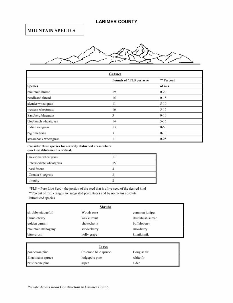
LARIMER COUNTY
Private Access Road Construction in Larimer County
MOUNTAIN SPECIES
Grasses
Pounds of *PLS per acre **Percent
Species of mix
mountain brome 19 0-20
needleand thread 15 0-15
slender wheatgrass 11 5-10
western wheatgrass 16 5-15
Sandberg bluegrass 3 0-10
bluebunch wheatgrass 14 5-15
Indian ricegrass 13 0-5
big bluegrass 3 0-10
streambank wheatgrass 11 0-25
Consider these species for severely disturbed areas where quick establishment is critical.
thickspike wheatgrass 11 1intermediate wheatgrass 15 1hard fescue 4 1Canada bluegrass 3 1timothy 2
*PLS = Pure Live Seed - the portion of the seed that is a live seed of the desired kind **Percent of mix - ranges are suggested percentages and by no means absolute 1 Introduced species
Shrubs shrubby ciuquefoil Woods rose common juniper thimbleberry wax currant skunkbush sumac golden currant chokecherry buffaloberry mountain mahogany serviceberry snowberry bitterbrush holly grape kinnikinnik
Trees
ponderosa pine Colorado blue spruce Douglas fir Engelmann spruce lodgepole pine white fir bristlecone pine aspen alder

LARIMER COUNTY
Private Access Road Construction in Larimer County
WILDFLOWERS
Another way of adding color to an area while keeping maintenance to a minimum is to seed wildflowers. Like native grasses, native wildflowers will thrive in areas where other commercial species will not. Many species have the additional benefit of being perennials. To determine which wildflowers are indigenous to your area, refer to �Wildflowers of America,� by H. W. Rickett (an 11-volume series available at your local library). Below are some suggested wildflowers.
PLAINS yarrow lance leaved coreopsis plains coreopsis perennial gaillardia annual gaillardia baby�s breath blue flax prairie coneflower smooth aster New England aster golden aster prairie aster blazing star/gayfeather scarlet globemallow plains wallflower
FOOTHILLS pasque flower silky lupine (poisonous to sheep) Indian paintbrush sulphur flower perennial lupine (poisonous to sheep) blue flax yarrow blazing star/gayfeather harebell low fleabane plains wallflower penstemon
MOUNTAINS
pasque flower Colorado blue columbine sulphur flower rose pussytoes Indian paintbrush baby�s breath bellflower wallflower fleabane daisy perennial gaillardia silky lupine (poisonous to sheep) dame�s rocket blue flax perennial lupine (poisonous to sheep) penstemmon catchfly yarrow Rocky Mountain iris arrowleaf balsam

NRCS 1999
A QUICK GUIDE TO GRASSES FOR THE DENVER FRONT RANGE FOOTHILL AND MONTANE ZONES
SPEC
IES
VAR
IETY
NAT
IVE/
INTR
OD
UC
ED
BUN
CH
GR
ASS/
SOD
FO
RM
ING
CO
OL/
WAR
M S
EASO
N
MIN
IMU
M P
REC
IPIT
ATIO
N IN
IN
CH
ED
ELEV
ATIO
N
HAB
ITAT
ACID
TO
LER
ANC
E
HIG
H W
ATER
TAB
LE
TOLE
RAN
CE
MAT
UR
E H
EIG
HT
IN F
EET
SOIL
TEX
TUR
E
CO
MM
ENTS
BRO
ADC
AST
LBS
PLS/
AC.
Arizona fescue Redondo N B C 14 6,500-10,500 open woods, rocky slopes M L 1 to 3 G, SL b 9 alpine bluegrass native N B C 20 8,500-13,500 tundra, gravelly slopes, H L <1 G, SL 6 big bluegrass Sherman N B C 10 5,000- 9,500 meadows, hills, valleys M M >2 G, SL 6 big bluestem Kaw N B W 15 3,500- 7,500 prairies, meadows, foothills M-L M 3 to 6 SL a 22 blue grama Lovington/ Hachita N B W 12 3,500-10,500 plains, prairies, hills L L <2 G, SL a 6 bluebunch wheatgrass Secar N B C 8 5,000- 8,000 dry slopes, rocky hills, open woods M L 1 to 2 G, SL b 28 Canada bluegrass Reubens I S C 15 3,500- 9,500 open ground, thin woods, waste places H-M M 1 to 2 G, SL 2 Canada wildrye Native N B C 12 3,500- 9,000 open woods L M >2 SL 32 Canby bluegrass Canbar N B C 10 4,500- 9,800 dry meadows, hills, open woods M M 1 to 2 G, SL 6 crested wheatgrass Hycrest/ Ephraim I B C 10 4,500- 9,000 M M-L 1 to 3 SL 20 green needlegrass Lodorm N B C 15 3,500- 8,000 plains, dry slopes, hills M H-M 1 to 2 SL 20 hard fescue Durar I B C 16 6,500-12,000 H-M L 1 to 3 G, SL 8 indian ricegrass Nezpar/Paloma N B C 9 4,000- 9,500 plains, canyons, hills M L 1 to 2 G, SL b 25 intermediate wheatgrass Amur/ Oahe I S C 14 4,500- 9,000 M M 2 to 4 SL 30 little bluestem pastura/Camper N B W 14 3,500- 8,000 prairies, dry hills, open woods M L 1 to 4 G, SL a 14 mountain brome Bromar N B C 16 5,000-10,000 open woods, meadows M L >2 SL c 38 needleandthread native N B C 10 3,500- 8,500 plains, prairies, dry hills M L >2 SL 30 prairie junegrass native N B C 12 3,500-11,500 prairies, open woods, rocky hillsides L L 1 to 2 SL 2 pubescent wheatgrass Luna I S C 14 4,500- 9,000 M M 1 to 2 SL 28 red fescue I B C 18 7,000-10,000 H-M L-M 1 to 3 G, SL d 8 redtop I S C 20 3,500- 9,000 meadows, wet meadows, streamsides H H >2 SL 1 Sandberg bluegrass native N B C 8 4,500-12,000 plains, dry woods, rocky hillsides L-M L 1 to 2 G, SL 6 sheep fescue Covar I B C 10 6,500-12,000 open woods, stony slopes H-M L 1 to 2 G, SL 8 sideoats grama Vaughn/ Butte N B W 8 3,500- 9,000 plains, hillsides, valleys M M 1 to 3 G, SL a 18 slender wheatgrass San Luis/ Primar N B C 16 4,500-12,000 hillsides, meadows M M 1 to 2 G, SL c 22 smooth brome Lincoln! Manchar I S C 12 4,500-10,000 M M 2 to 4 SL 26 streambank wheatgrass Sodar N S C 8 4,500- 9,000 meadows, hills M M-L >2 SL 22 thickspike wheatgrass Critana N S C 8 5,000-10,000 plains, sandy or gravelly soil M M-L 1 to 2 SL 22 tufted hairgrass native N B C 20 7,000-13,000 bogs, wet meadows H H 1 to 2 SL 2 western wheatgrass Rosanal Arriba N S C 10 3,500-10,500 hills, plains M H 1 to 3 G, SL 32

ADAPTABILITY RATINGS: SOIL TEXTURE:
H = High G = Decomposed granite, Gravel M = Moderate SL = Sandy loam L = Low
COMMENTS: a = Should be planted on south and west facing slopes, or open areas that receive direct sunlight. b = Not recommended for north facing slopes c = Short-lived perennial d = Very shade tolerant
EXAMPLE FOR DETERMINING SEEDING RATES IN MIXTURES:
Species
Variety
Mix %
Broadcast Lbs. PLS/Acre
Desired Seeding rate
Arizona fescue Redondo. 30 X 9 = 2.7 Slender wheatgrass San Luis 15 X 22 = 3.3 Blue grama Lovington 15 X 6 = 0.9 Streambank wheatgrass Sodar 30 X 22 = 6.6 Indian ricegrass Nezpar 10 X 25 = 2.5
BIBLIOGRAPHY: Arkansas Valley Seed Co., Seeding Information For Pasture And Reclamation Species Grassland West, Reclamation Products Catalog Harrington, H.D., Manual Of The Plants Of Colorado NRCS, Standards & Specifications: Critical Area Planting #342 NRCS, Colorado Agronomy Note #61: Seeding Rates NRCS, Plant Materials Note #59: Recommended Grass Cultivars In Colorado Weber, William A. Colorado Flora Eastern Slope
NRCS 1999 (continued)

Denver Regional Council of Governments
Wright Water Engineers, Inc.2490 W. 26th Avenue
Suite 100ADenver, Colorado 80211www.wrightwater.com
Denver Regional Council of Governments2480 W. 26th Avenue
Suite 200BDenver, Colorado 80211
www.drcog.org