moseley conservation area
TRANSCRIPT
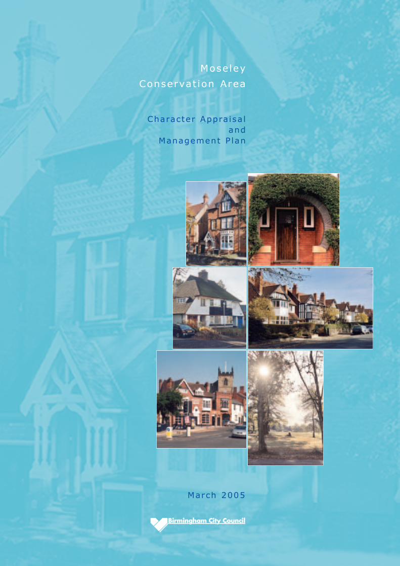
Moseley
Conservat ion Area
March 2005
Character Appra isa l and
Management P lan
Pitmaston Court
Contents
1
ContIntroduction
Part A Moseley Conservation Area Character Appraisal(Adopted as Supplementary Planning Guidance, March 2005)
1 Location
2 Geology and Topography
3 The Conservation Area
4 History
5 The Development
6 The Character
7 Street Descriptions
8 Moseley Hall, Park and Pool
9 Trees, Hedges and Walls
Part B Moseley Conservation Area Management Plan
1 Management Plan(Article 4(2) Direction implemented, May 2005)
Appendix A Statutory and Locally Listed Buildings
Appendix B Archaeology
Appendix C Background Reading
Page
3
5
6
7
8
9
10
12
13
22
23
25
27
32
34
35
2
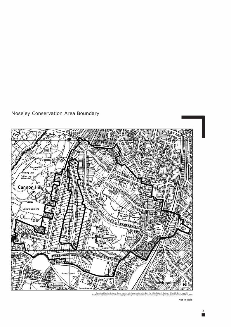
Moseley Conservation Area Boundary
N
Not to scale
Introduction
3
The Moseley Conservation Area CharacterAppraisal and Management Plan comply withGovernment and City Council policy and will beused as a material consideration in determiningplanning applications. It was adopted asSupplementary Planning Guidance in March 2005.
Information for the street descriptions was providedlargely by members of the Moseley Society. Acomprehensive digital photographic survey of MoseleyConservation Area has been provided by Dr RoyCockel from the Moseley Society and is held by theConservation Group within Planning. It is available forconsultation.
The Moseley Society is a registered charity which wasfounded in 1979 with the aim of preserving the specialcharacter of Moseley. Further details about the Societycan be obtained from their website at www.moseley-society.org.uk or by emailing [email protected]
The 1990 Planning (Listed Buildings andConservation Areas) Act defines a conservationarea as “an area of architectural or historic interest,the character and appearance of which it isdesirable to preserve or enhance”. The localauthority has a duty to review its designatedconservation areas and publish managementproposals for the preservation and enhancement ofthese areas.
Moseley Conservation Area was designated on 17thMarch 1983; it covers an area of 52.81 hectares.This Character Appraisal of Moseley ConservationArea and associated Management Plan has beenprepared with the assistance of the MoseleySociety according to English Heritage guidelines.They should be read as complementarydocuments. The Character Appraisal aims toidentify the special interest of the conservation areaand define its character whilst the ManagementPlan is intended to be a guide to the form and styleof future development within the area.
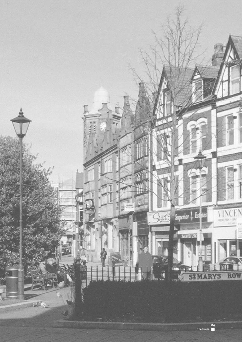
Moseley still retains a village character and its focalpoint is the “Green” at the crossroads with StMary’s Row, Salisbury Road and Alcester Road.This is the heart of Moseley where shops, pubs,cafes and restaurants provide a lively andcosmopolitan character. St Mary’s Church is theParish church and provides an impressivebackdrop to the historic centre of Moseley.
Moseley is a suburb of Birmingham whichdeveloped from around 1860 through to theInterwar period and boasts a wide variety ofarchitectural styles ranging from mid Victorianvillas, individual architect-built Arts and Craftshouses, impressive three storey Edwardianresidences, modest railway workers cottages andInter and Post War semi-detached dwellings.
Int
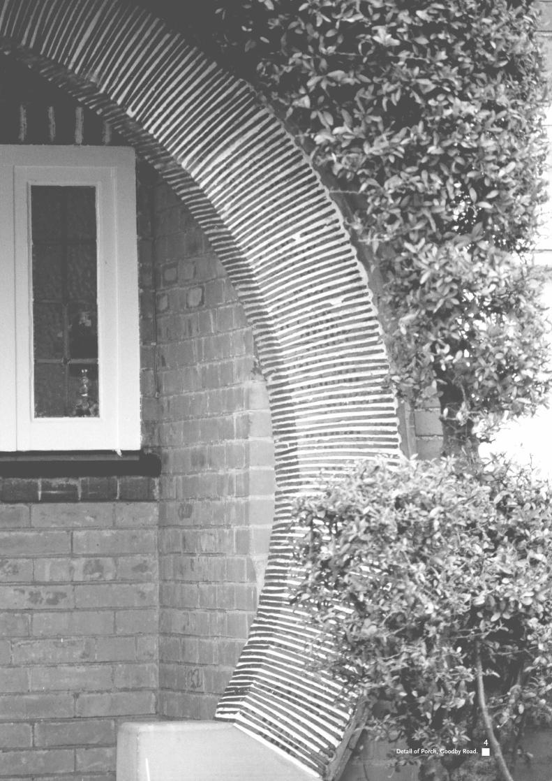
4Detail of Porch, Goodby Road.
5
Moseley
Conservat ion Area
Part A
Character Appra isa l
6
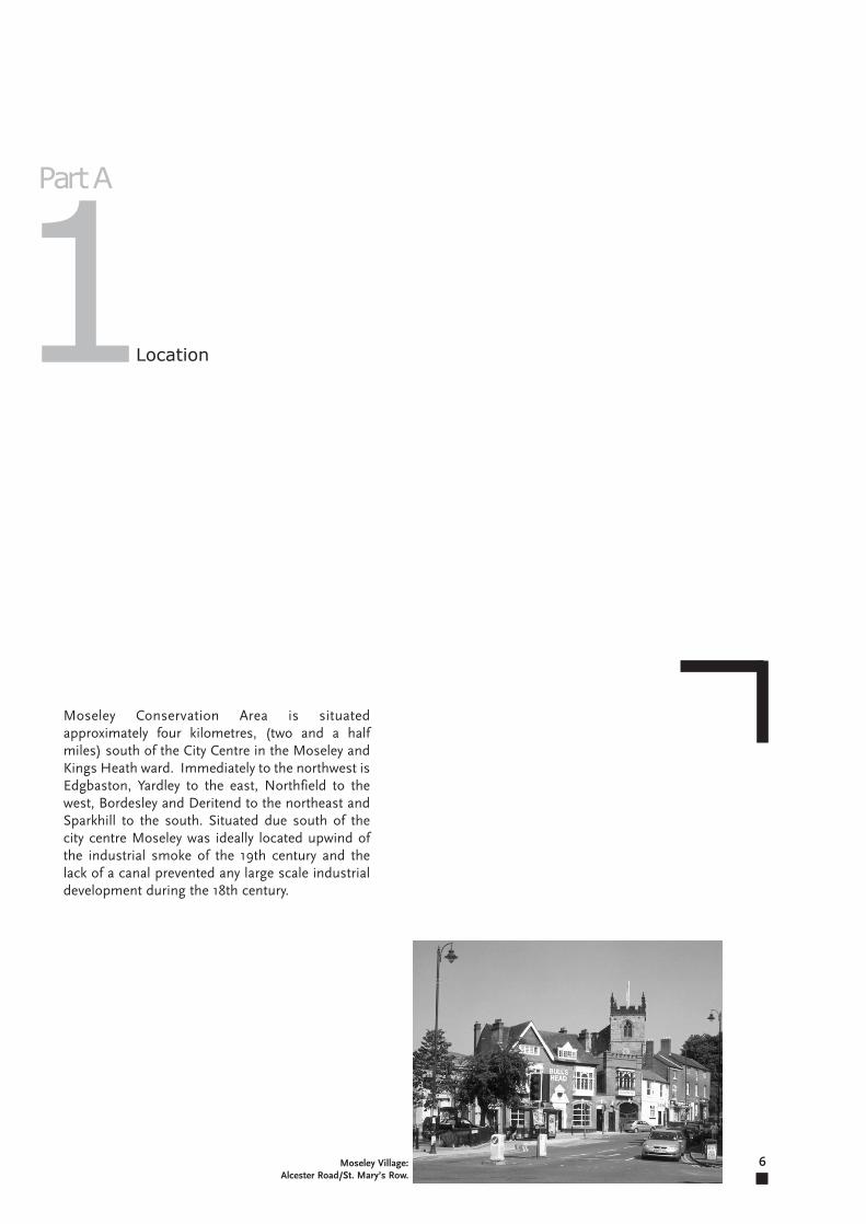
Moseley Conservation Area is situatedapproximately four kilometres, (two and a halfmiles) south of the City Centre in the Moseley andKings Heath ward. Immediately to the northwest isEdgbaston, Yardley to the east, Northfield to thewest, Bordesley and Deritend to the northeast andSparkhill to the south. Situated due south of thecity centre Moseley was ideally located upwind ofthe industrial smoke of the 19th century and thelack of a canal prevented any large scale industrialdevelopment during the 18th century.
Location1Part A
Moseley Village:Alcester Road/St. Mary’s Row.
Geology and Topography
7
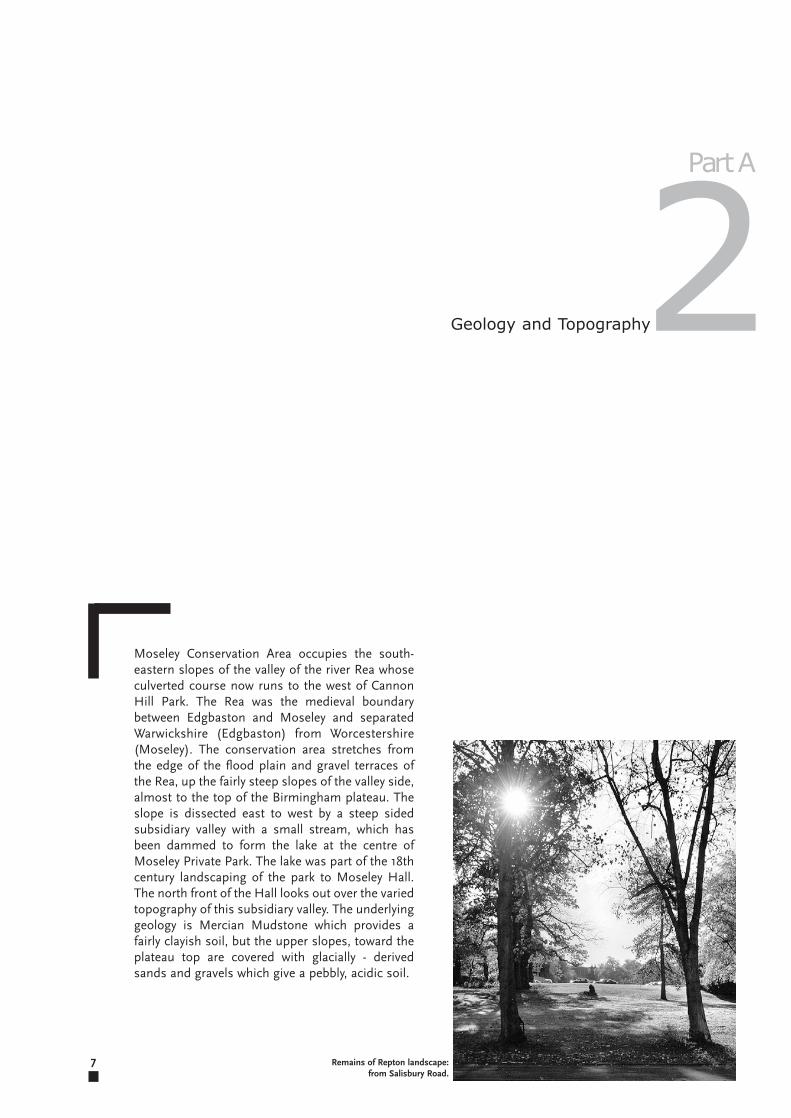
Moseley Conservation Area occupies the south-eastern slopes of the valley of the river Rea whoseculverted course now runs to the west of CannonHill Park. The Rea was the medieval boundarybetween Edgbaston and Moseley and separatedWarwickshire (Edgbaston) from Worcestershire(Moseley). The conservation area stretches fromthe edge of the flood plain and gravel terraces ofthe Rea, up the fairly steep slopes of the valley side,almost to the top of the Birmingham plateau. Theslope is dissected east to west by a steep sidedsubsidiary valley with a small stream, which hasbeen dammed to form the lake at the centre ofMoseley Private Park. The lake was part of the 18thcentury landscaping of the park to Moseley Hall.The north front of the Hall looks out over the variedtopography of this subsidiary valley. The underlyinggeology is Mercian Mudstone which provides afairly clayish soil, but the upper slopes, toward theplateau top are covered with glacially - derivedsands and gravels which give a pebbly, acidic soil.
2
Remains of Repton landscape:from Salisbury Road.
Part A
8
The Conservation Area
The southern boundary of the Conservation Areacommences at no.215 Alcester Road and includesthe north side of Moor Green Lane (nos.1-55) butexcludes the modern properties at the eastern endof the road, (nos.57-71). The boundary then followsthe line of Moor Green Lane as it loops around thesports ground. At Holders Lane the boundary skirtsthe Pitmaston site until no.42 Mapperley Gardensbut excludes nos.2-20 and no.17. The boundarythen continues around the outside perimeter ofPitmaston Court and the rear of nos.9-29 GoodbyRoad and nos.62 and 64 Russell Road (nb.Moorcroft Road is not included in the ConservationArea).
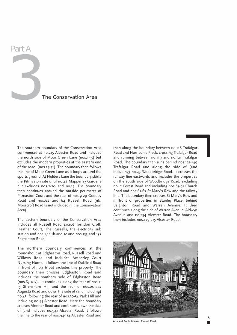
The eastern boundary of the Conservation Areaincludes all Russell Road except Torridon Croft,Heather Court, The Russells, the electricity substation and nos.1,1a,1b and 1c and nos.135 and 137Edgbaston Road.
The northern boundary commences at theroundabout at Edgbaston Road, Russell Road andWillows Road and includes Amberley CourtNursing Home. It follows the line of Oakfield Roadin front of no.116 but excludes this property. Theboundary then crosses Edgbaston Road andincludes the southern side of Edgbaston Road(nos.83-107). It continues along the rear of nos.1-15 Strensham Hill and the rear of nos.20-22aAugusta Road and down the side of (and including)no.43, following the rear of nos.10-54 Park Hill andincluding no.45 Alcester Road. Here the boundarycrosses Alcester Road and continues down the sideof (and includes no.94) Alcester Road. It followsthe line to the rear of nos.94-114 Alcester Road and
3
Arts and Crafts houses: Russell Road.
Part A
then along the boundary between no.116 TrafalgarRoad and Harrison’s Pleck, crossing Trafalgar Roadand running between no.119 and no.121 TrafalgarRoad. The boundary then runs behind nos.121-149Trafalgar Road and along the side of (andincluding) no.43 Woodbridge Road. It crosses therailway line eastwards and includes the propertieson the south side of Woodbridge Road, excludingno. 2 Forest Road and including nos.85-91 ChurchRoad and nos.61-67 St Mary’s Row and the railwayline. The boundary then crosses St Mary’s Row andin front of properties in Stanley Place, behindLeighton Road and Warren Avenue. It thencontinues along the side of Warren Avenue, AldwynAvenue and no.234 Alcester Road. The boundarythen includes nos.179-215 Alcester Road.
History
9
The Grevis family lived beyond their means,leading to the eventual sale of their land. HenshawGrevis, the last in the line sold all that remained ofthe estate in 1766 in order to pay off debts.
In 1766 John Taylor, successful businessman andco-founder of Lloyd’s Bank, bought the Yardleyestates, together with the lordship, and as aresidence for his family, Moseley Hall. The Hallburnt down in riots in 1791 and was rebuilt fiveyears later by John Taylor II whose descendentslived here until 1852.
Moseley in the late 19th century had become aprosperous suburb, largely due to the effect of therailway station and its proximity to the city centre.
Moseley was situated in the manor of Kings Nortonand with its absentee landlord, it was possible foryeomen to improve their status. In 1086 DomesdayBook listed the area as a ‘Berewick of Bromsgroev’,and Moseley as ‘Muselei’, which could possibly betranslated as ‘Field Mice Clearing’, a Saxon name.It was ideally located for a settlement with an oakforest to the west and north and boggy meadowson the edge of a river which could be dammed,providing food, grazing, timber and water.
Tudor Moseley comprised a collection of halftimbered houses gathered around the Green atAlcester Road and St Mary’s Row and Moseley OldHall (demolished in 1842), home of the Grevisfamily, was situated near to the present St Anne’sChurch, Alcester Rd. Thomas Grevis was aprosperous yeoman until the reign of Henry VIIIand at the time of the Dissolution, he bought anumber of estates which had been confiscatedfrom religious houses and thus came to be anotable landowner in Moseley, South Yardley andMonyhull.
Sir Richard Grevis held high office under James Iand lived in Moseley Old Hall, off Alcester Road.His descendent, also called Richard, built amansion in parkland in 1681 on the site of thepresent Moseley Hall. The park was bounded byPark Hill, Alcester Road and ancient footpathswhich are now known as Moor Green Lane andRussell Road and on the southern edge was a walland ha-ha.
4Part A
By the 1870s Moseley was no longer a rural village,but boasted gas lighting, a railway station andsteam trams with a terminus in the village.Moseley railway station had an enormous impacton the development of the area and the landbetween the railway and the eastern edge ofAlcester Road had been densely developed to thenorth, towards Brighton Road railway station. Thesouthern side of St Mary’s Row, turning the cornerinto Alcester Road had also been developed.Blayney Street (now Woodbridge Road) had alsobeen cut, providing access, via a wooden bridge, tothe railway station which was built in 1868.
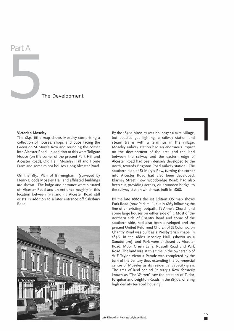
By the late 1880s the 1st Edition OS map showsPark Road (now Park Hill), cut in 1865 following theline of an existing footpath, St Anne’s Church andsome large houses on either side of it. Most of thenorthern side of Chantry Road and some of thesouthern side, had also been developed and thepresent United Reformed Church of St Columba onChantry Road was built as a Presbyterian chapel in1896. In the 1880s Moseley Hall, (shown as aSanatorium), and Park were enclosed by AlcesterRoad, Moor Green Lane, Russell Road and ParkRoad. The land was at this time in the ownership ofW F Taylor. Victoria Parade was completed by theturn of the century thus extending the commercialcentre of Moseley as its residential capacity grew.The area of land behind St Mary’s Row, formerlyknown as ‘The Warren’ saw the creation of Tudor,Farquhar and Leighton Roads in the 1890s, offeringhigh density terraced housing.
10
Victorian MoseleyThe 1840 tithe map shows Moseley comprising acollection of houses, shops and pubs facing theGreen on St Mary’s Row and rounding the cornerinto Alcester Road. In addition to this were TollgateHouse (on the corner of the present Park Hill andAlcester Road), Old Hall, Moseley Hall and HomeFarm and some minor houses along Alcester Road.
On the 1857 Plan of Birmingham, (surveyed byHenry Blood) Moseley Hall and affiliated buildingsare shown. The lodge and entrance were situatedoff Alcester Road and an entrance roughly in thislocation between 93a and 95 Alcester Road stillexists in addition to a later entrance off SalisburyRoad.
The Development5Part A
Late Edwardian houses: Leighton Road.
11
Edwardian MoseleyBy 1904, the 2nd Edition OS map shows thatMoseley Hall had been severed from the park withthe cutting in 1896 of Salisbury Road (named afterthe Prime Minister, Lord Salisbury). It was a mainroute into and out of the city centre and by the firstyears of the 20th century trams had been replacedby a regular bus service. In 1911 Moseley, Yardleyand King’s Norton were incorporated into the Cityboundary and were no longer identified asindependent villages, but suburbs of Birmingham.
The 1916 3rd Edition OS map shows thedevelopment of the north side of Reddings Road(formerly Reddings Lane) and the cutting anddevelopment of Amesbury Road. This furthercompromised the setting of Moseley Hall as it wasnow surrounded by residential properties.
Interwar MoseleyDuring the interwar years Moseley continued toexpand westwards towards Pitmaston and CannonHill House. Russell Road is shown on the 4thEdition OS map of 1936, as are the grounds ofChantry Glade (formerly Chantry Glen), completingthe development of the eastern side of SalisburyRoad. The western side of Salisbury Road was alsocompleted at this time and interwar detached andsemi detached housing appeared.
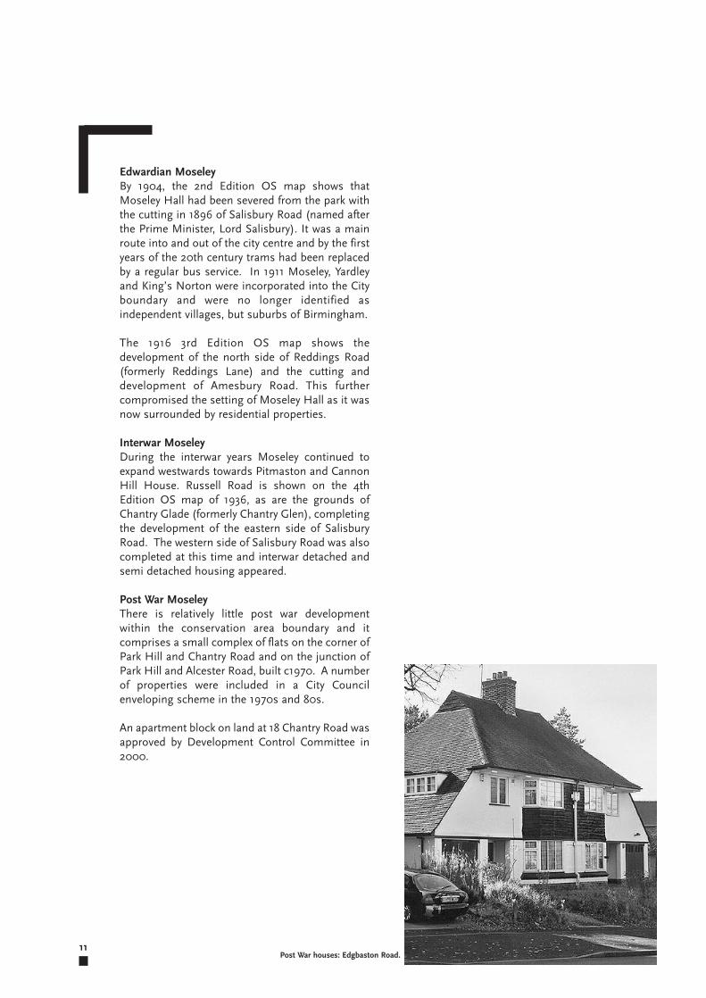
Post War MoseleyThere is relatively little post war developmentwithin the conservation area boundary and itcomprises a small complex of flats on the corner ofPark Hill and Chantry Road and on the junction ofPark Hill and Alcester Road, built c1970. A numberof properties were included in a City Councilenveloping scheme in the 1970s and 80s.
An apartment block on land at 18 Chantry Road wasapproved by Development Control Committee in2000.
Post War houses: Edgbaston Road.
12
There are five discrete building types in theconservation area. These include:
i. The historic hamlet of Moseley village,comprising the parish church of St Mary, villagegreen, pubs and shops with living accommodationabove on Alcester Road. A regular Farmers’ marketis held on the Green, generating an active and livelyatmosphere.
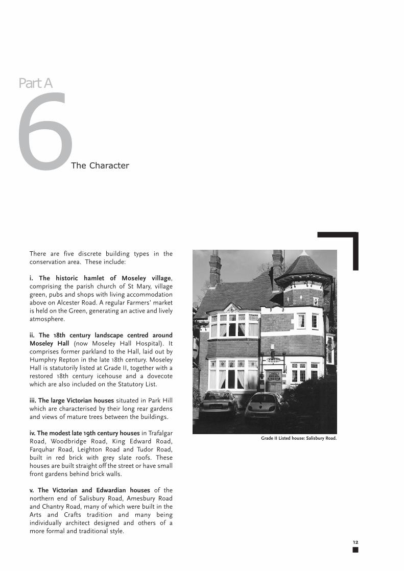
ii. The 18th century landscape centred aroundMoseley Hall (now Moseley Hall Hospital). Itcomprises former parkland to the Hall, laid out byHumphry Repton in the late 18th century. MoseleyHall is statutorily listed at Grade II, together with arestored 18th century icehouse and a dovecotewhich are also included on the Statutory List.
iii. The large Victorian houses situated in Park Hillwhich are characterised by their long rear gardensand views of mature trees between the buildings.
iv. The modest late 19th century houses in TrafalgarRoad, Woodbridge Road, King Edward Road,Farquhar Road, Leighton Road and Tudor Road,built in red brick with grey slate roofs. Thesehouses are built straight off the street or have smallfront gardens behind brick walls.
v. The Victorian and Edwardian houses of thenorthern end of Salisbury Road, Amesbury Roadand Chantry Road, many of which were built in theArts and Crafts tradition and many beingindividually architect designed and others of amore formal and traditional style.
The Character6Part A
Grade II Listed house: Salisbury Road.
13
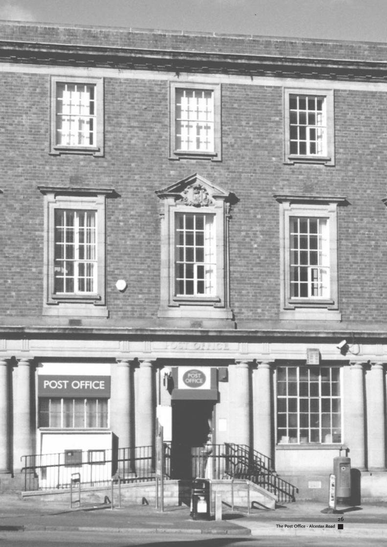
and are situated behind sandstone walls and hollyor privet hedges, many of which remain. Theexception to this is “Moseley Gate”, a mix of officeand residential development, built c.2000 which islocated directly behind no.171 and is accessed by adriveway to the side. It is built of a yellow brickwhich is inconsistent with the existing character ofthe area. ‘The Village’ public house is convertedfrom a large late Victorian villa; its car park has avery sterile appearance and could benefit fromlandscaping. The Post Office dates from the early20th century. It is built from brick with stonedressings with neo Classical details. There are cyclestands, litterbins and an information panel on thepavement outside.
The Café Bar has been drastically altered, with abrick forecourt contained within stainless steelrails. The alterations have made the building aliento the character of the conservation area with theuse of stainless steel and a modern, open plandesign.
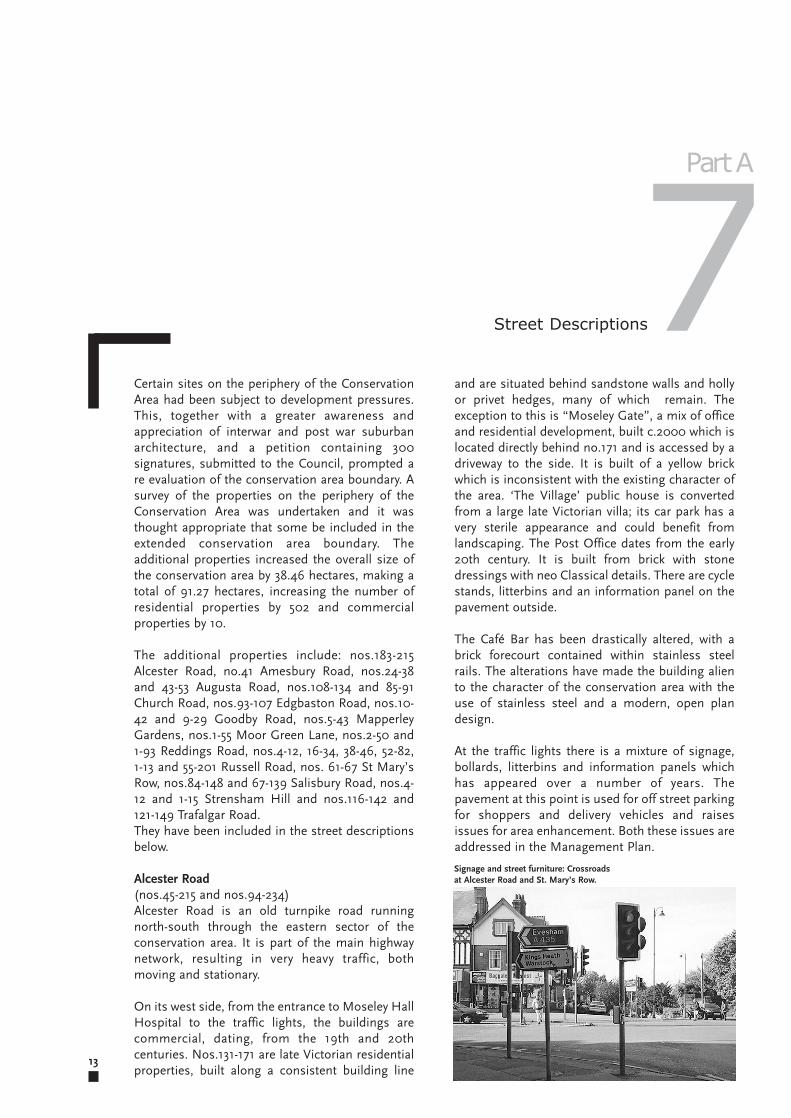
At the traffic lights there is a mixture of signage,bollards, litterbins and information panels whichhas appeared over a number of years. Thepavement at this point is used for off street parkingfor shoppers and delivery vehicles and raisesissues for area enhancement. Both these issues areaddressed in the Management Plan.
Certain sites on the periphery of the ConservationArea had been subject to development pressures.This, together with a greater awareness andappreciation of interwar and post war suburbanarchitecture, and a petition containing 300signatures, submitted to the Council, prompted are evaluation of the conservation area boundary. Asurvey of the properties on the periphery of theConservation Area was undertaken and it wasthought appropriate that some be included in theextended conservation area boundary. Theadditional properties increased the overall size ofthe conservation area by 38.46 hectares, making atotal of 91.27 hectares, increasing the number ofresidential properties by 502 and commercialproperties by 10.
The additional properties include: nos.183-215Alcester Road, no.41 Amesbury Road, nos.24-38and 43-53 Augusta Road, nos.108-134 and 85-91Church Road, nos.93-107 Edgbaston Road, nos.10-42 and 9-29 Goodby Road, nos.5-43 MapperleyGardens, nos.1-55 Moor Green Lane, nos.2-50 and1-93 Reddings Road, nos.4-12, 16-34, 38-46, 52-82,1-13 and 55-201 Russell Road, nos. 61-67 St Mary’sRow, nos.84-148 and 67-139 Salisbury Road, nos.4-12 and 1-15 Strensham Hill and nos.116-142 and121-149 Trafalgar Road.They have been included in the street descriptionsbelow.
Alcester Road(nos.45-215 and nos.94-234)Alcester Road is an old turnpike road runningnorth-south through the eastern sector of theconservation area. It is part of the main highwaynetwork, resulting in very heavy traffic, bothmoving and stationary.
On its west side, from the entrance to Moseley HallHospital to the traffic lights, the buildings arecommercial, dating, from the 19th and 20thcenturies. Nos.131-171 are late Victorian residentialproperties, built along a consistent building line
Street Descriptions7Part A
Signage and street furniture: Crossroadsat Alcester Road and St. Mary’s Row.
King Edward Road are Victorian and Edwardianand are the small scale individual commercial unitswhich give Moseley its special character althoughthe appearance of some of these buildings ismarred by roller shutters. Traditional shopfrontscomprise a recessed entrance, low stallrisers, slimpilasters and a well proportioned fascia.Unsympathetic alterations which have changed theproportions, materials and detailing, together withoversized signage and fascias are detracting fromthe character of the conservation area. The 1960sbuildings are poor quality both in terms ofmaterials and design and the use of concrete isalien and unsympathetic and has a negative impacton the character of the conservation area.However, the Sainsbury’s supermarket is acompletely new building, (c.2002) which hasretained the original façade only but has been builtto a high standard in terms of design and materialsand has a positive impact on the conservation area.Such high standards should be used as a markerfor future new development within theconservation area.
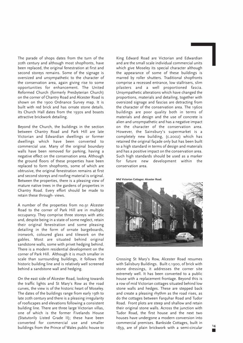
Crossing St Mary’s Row, Alcester Road resumeswith Salisbury Buildings. Built c.1900, of brick withstone dressings, it addresses the corner siteextremely well. It has been converted to a publichouse with a replacement frontage. Beyond this isa row of mid Victorian cottages situated behind lowstone walls and hedges. These are stepped backand create a pleasing rhythm as the road rises, asdo the cottages between Farquhar Road and TudorRoad. Front plots are steep and shallow and retaintheir original stone walls. Across the junction withTudor Road, the first house and the next twohouses have undergone a modern conversion intocommercial premises. Bankside Cottages, built in1859, are of plain brickwork with a semi-circular 14
The parade of shops dates from the turn of the20th century and although most shopfronts, havebeen replaced, the original fenestration at first andsecond storeys remains. Some of the signage isoversized and unsympathetic to the character ofthe conservation area, again giving rise to someopportunities for enhancement. The UnitedReformed Church (formerly Presbyterian Church)on the corner of Chantry Road and Alcester Road isshown on the 1900 Ordnance Survey map. It isbuilt with red brick and has ornate stone details.Its Church Hall dates from the 1930s and boastsattractive brickwork detailing.
Beyond the Church, the buildings in the sectionbetween Chantry Road and Park Hill are lateVictorian and Edwardian dwellings or formerdwellings which have been converted tocommercial use. Many of the original boundarywalls have been removed for parking, having anegative effect on the conservation area. Althoughthe ground floors of these properties have beenreplaced to form shopfronts, some of which areobtrusive, the original fenestration remains at firstand second storeys and roofing material is original.Between the properties, there is a pleasing view ofmature native trees in the gardens of properties inChantry Road. Every effort should be made toretain these through- views.
A number of the properties from no.91 AlcesterRoad to the corner of Park Hill are in multipleoccupancy. They comprise three storeys with atticand, despite being in a state of some neglect, retaintheir original fenestration and some pleasingdetailing in the form of ornate bargeboards,ironwork, coloured glass and tilework on thegables. Most are situated behind originalsandstone walls, some with privet hedging behind.There is a modern residential development on thecorner of Park Hill. Although it is much smaller inscale than surrounding buildings, it follows thehistoric building line and is relatively well screenedbehind a sandstone wall and hedging.
On the east side of Alcester Road, looking towardsthe traffic lights and St Mary’s Row as the roadcurves, the view is of the historic heart of Moseley.The dates of the buildings range from early 19th tolate 20th century and there is a pleasing irregularityof roofscapes and elevations following a consistentbuilding line. There are three large Victorian villas,one of which is the former Fivelands House(Statutorily Listed Grade II); these have beenconverted for commercial use and smallerbuildings from the Prince of Wales public house to
Mid Victorian Cottages: Alcester Road.
15
Permitted Development, the cumulative effect ofwhich could compromise their setting and erodethe character of the conservation area. An Article 4(2) Direction on these properties will prevent thisincremental damage.
Although the houses are individually designed,there is a consistency of scale, massing andmaterials and each property displays Arts andCrafts influences. Looking along the road towardsReddings Road, the dominating features are tall,ornate chimneys and steeply pitched gables. Mostof the roofs are covered with red clay tiles althoughthere are a few examples of the use ofWestmoreland slate in diminishing courses. Mostof the original fenestration and front doors remain.The views between the houses are of dense andmature trees and every effort should be made topreserve them.
No.41 is a detached dwellinghouse, built c.1910.Three storeyed with dormers, a slate roof,imposing chimneys, projecting eaves, it addressesboth Amesbury Road and Reddings Road. It retainsits coloured glass at ground floor.
It is a wide road with very few street trees. Only thewest side of the road is residential, the east sideborders the grounds of Moseley Hall hospital. Atoff-peak hours it is a quiet road with very littlemoving traffic. The road retains its granite kerbs.
brick arch above each front door and a flat brickarch above each ground floor window and singleupper storey window. Red brick boundary wallswith blue coping bricks define short front gardens.Alterations visible from the street are minimal.Many front doors and windows are originalalthough some sash windows have been replacedwith hinged casements. Slate roofs and clay ridgetiles and chimneys have been retained everywhere. Looking back along Alcester Road towards thetraffic lights, the view is dominated by the cupola ofthe Fighting Cocks public house.
Nos.183-215 are substantial brick houses built inthe Edwardian era. They are set fairly close to theroad, behind low walls and hedging. The nursinghome was built c.1890 and has a similar scale andmassing to the individual houses. It has a neutralimpact on the conservation area.
Aldwyn Avenue(All properties, also Leighton Road, Tudor Road,Farquhar Road, Chandos Avenue and WarrenAvenue)Built on land formerly known as The Warren, theseroads of modest two storey terraced houses werebuilt c1890. They are of red brick with slate roofsand, with the exception of Aldwyn and WarrenAvenues, are situated close to the road behindbrick walls. Aldwyn Avenue is secluded behind agate off Tudor Road with a wide approach withgrass on either side of a path planted with youngtrees; houses boast long front gardens.
There is evidence of parking difficulties, but theoverall character of these roads is of quietseclusion.
Amesbury Road(nos.2-46 and no.41) Amesbury Road runs from the corner withSalisbury Road adjacent to no.59 and terminates atits junction with Reddings Road. It was developedfrom about 1906 and is an outstanding example ofdetached Arts and Crafts houses. All the houses arelarge and were built on generous plots with longrear gardens. They represent examples of the workof prestigeous contemporary architects such asOwen P Parsons, W H Bidlake and HollandHobbiss. With the exception of no.6, The Hurst,which has been converted into flats, all the housesare in single family occupation. Most of the frontgardens have been altered and there is a mixture oftreatment of boundary walls, few of them beingoriginal. Given the size and scale of the plots, thesehouses are under threat of alteration through
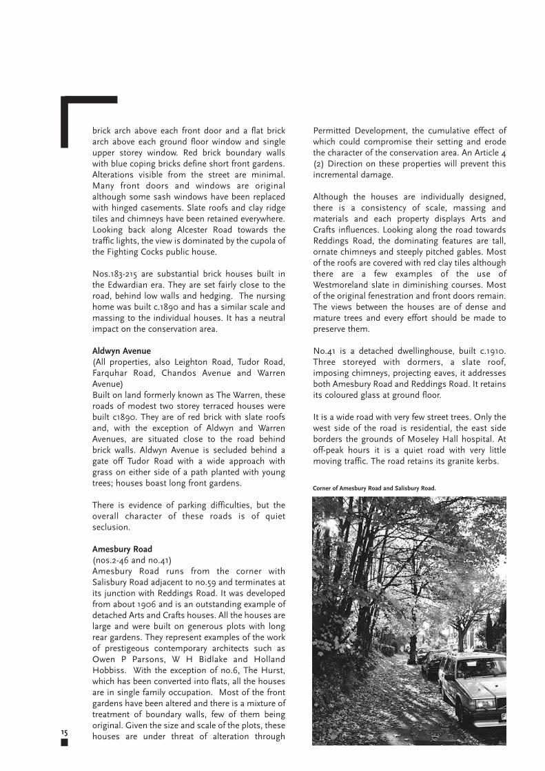
Corner of Amesbury Road and Salisbury Road.
hanging, ornate plasterwork and coloured glass.The roofing materials are either of grey slate or redclay tiles. In addition to this, the houses in ChantryRoad are characterised by their distinctivewindows, doors, porches, boundary walls andchimneys. These architectural details should beretained. The views between the propertiescomprise mature trees and every effort should bemade to retain them. The Catholic School of Ss.John and Monica is and set back from the road andis well screened by mature planting. Close to theschool is a concealed entrance to a secluded part ofMoseley Park. At the end of Chantry Road, StAnne’s Court is a three storey moderndevelopment of flats, built c.1970 of red brick. Itoccupies a corner site and is set back from the roadwith open plan landscaping. The original limestoneblock wall partially remains and acts as a retainingwall to the development. It has a neutral impact onthe conservation area.
Church Avenue(nos.1-6 and 7-12 also Stanley Place nos.1-6)Accessed from St Mary’s Row, Church Avenue is aquiet, secluded cul de sac of late Victorian cottageswhich are set back behind low timber fences andfront gardens. The cottages were refurbished underan Urban Renewal Scheme which comprisednatural slate roofs, rebuilt chimneys and slidingtimber sash windows.
Church Road(nos.108-134 and 85-91)These substantial late Victorian dwellings are setwell back behind original stone walls and hedges.Although many have been sub divided into flats,many original features remain.
Edgbaston Road(nos.93-107)These modest semi deatched houses were built inthe 1920s in a pared down Arts and Crafts style.They are rendered brick with plain clay tile roofs.The steeply sloping roof above the integratedgarage contains a square dormer at first floor onsome properties. Front doors are deeply recessedand canted bay windows rise through ground andfirst floor. Many original boundary walls have beenremoved.
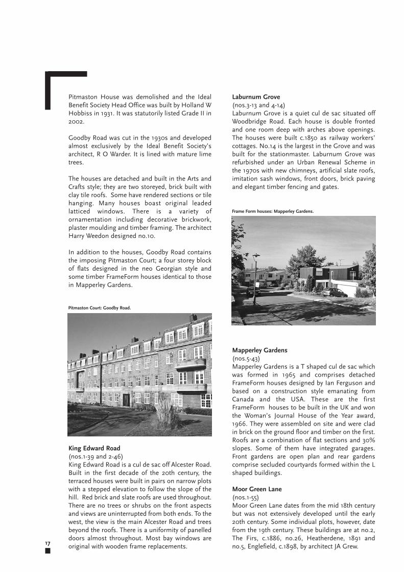
Goodby Road(nos.10-42 and 9-29)Goodby Road and Mapperley Gardens were builton the extensive Pitmaston Estate whose VictorianGardens still exist. The Pitmaston Estate was soldoff in the 1920s to the Ideal Benefit Society. 16
Turning the corner from Salisbury Road, the line ofparked cars, presumably serving the hospital,detract from the amenity of Amesbury Road. Thehospital complex itself is screened almostcompletely as far as the entrance opposite no.14 byan established hedge of beech, holly, hawthorn andmore recently planted ornamental shrubs. Growinginto the hedge is a mature oak tree and somesaplings which have matured. Beyond the entranceopposite no.14 the dense screening stops and anopen parkland is revealed and the sound ofbirdsong may be heard. To continue the screeningmay be considered as an enhancement proposal.
Augusta Road(nos.24-38 and 43-53)These properties are modest, semi detachedInterwar houses. They are brick-built with clay tileroofs. Some of the houses are rendered, somepartially rendered and others left plain. This,combined with the diversity of bay windows,creates a pleasing visual variety. Most housesretain their original brick boundary walls, althoughsome fenestration has been lost.
Caroline Place(nos.3-13 and 4-14)Caroline Place is a terrace of four houses builtc.1890 with access via an entry from WoodbridgeRoad between nos.14 and 18. The houses havearched brick openings and blue brick stringcoursing. The terrace was refurbished under anUrban Renewal Scheme in the 1970s with newchimneys, artificial slate roofs and imitation sashwindows.
Chantry Road(nos.4-64 and 5-69)Chantry Road is one of the most prestigious andimpressive roads in the Moseley VillageConservation Area. It is a tree-lined road whichgently winds to the left and at the junction withAlcester Road, the visual amenity of the roadsuffers from parked cars.
Chantry Road was cut and developed by the end ofthe 19th century. The houses are a mix of detachedand semi detached three storey dwellings set backfrom the road behind original limestone walls withholly or privet planting behind. There are also manymature trees in the gardens. Often the ground hasbeen excavated to accommodate garage or parkingspace beneath the houses. The houses on thenorth side of the road, backing onto Park Hill havelong rear gardens. There is a consistency of scale,massing and materials with the use of red brick, tile
17
Laburnum Grove(nos.3-13 and 4-14)Laburnum Grove is a quiet cul de sac situated offWoodbridge Road. Each house is double frontedand one room deep with arches above openings.The houses were built c.1850 as railway workers’cottages. No.14 is the largest in the Grove and wasbuilt for the stationmaster. Laburnum Grove wasrefurbished under an Urban Renewal Scheme inthe 1970s with new chimneys, artificial slate roofs,imitation sash windows, front doors, brick pavingand elegant timber fencing and gates.
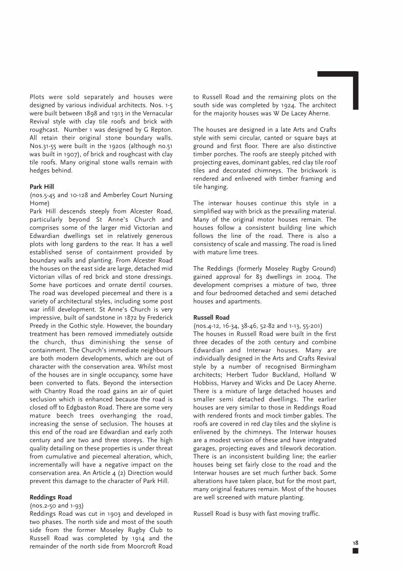
Mapperley Gardens(nos.5-43)Mapperley Gardens is a T shaped cul de sac whichwas formed in 1965 and comprises detachedFrameForm houses designed by Ian Ferguson andbased on a construction style emanating fromCanada and the USA. These are the firstFrameForm houses to be built in the UK and wonthe Woman’s Journal House of the Year award,1966. They were assembled on site and were cladin brick on the ground floor and timber on the first.Roofs are a combination of flat sections and 30%slopes. Some of them have integrated garages.Front gardens are open plan and rear gardenscomprise secluded courtyards formed within the Lshaped buildings.
Moor Green Lane(nos.1-55)Moor Green Lane dates from the mid 18th centurybut was not extensively developed until the early20th century. Some individual plots, however, datefrom the 19th century. These buildings are at no.2,The Firs, c.1886, no.26, Heatherdene, 1891 andno.5, Englefield, c.1898, by architect JA Grew.
Pitmaston House was demolished and the IdealBenefit Society Head Office was built by Holland WHobbiss in 1931. It was statutorily listed Grade II in2002.
Goodby Road was cut in the 1930s and developedalmost exclusively by the Ideal Benefit Society’sarchitect, R O Warder. It is lined with mature limetrees.
The houses are detached and built in the Arts andCrafts style; they are two storeyed, brick built withclay tile roofs. Some have rendered sections or tilehanging. Many houses boast original leadedlatticed windows. There is a variety ofornamentation including decorative brickwork,plaster moulding and timber framing. The architectHarry Weedon designed no.10.
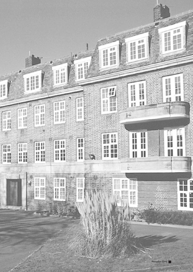
In addition to the houses, Goodby Road containsthe imposing Pitmaston Court; a four storey blockof flats designed in the neo Georgian style andsome timber FrameForm houses identical to thosein Mapperley Gardens.
King Edward Road(nos.1-39 and 2-46)King Edward Road is a cul de sac off Alcester Road.Built in the first decade of the 20th century, theterraced houses were built in pairs on narrow plotswith a stepped elevation to follow the slope of thehill. Red brick and slate roofs are used throughout.There are no trees or shrubs on the front aspectsand views are uninterrupted from both ends. To thewest, the view is the main Alcester Road and treesbeyond the roofs. There is a uniformity of panelleddoors almost throughout. Most bay windows areoriginal with wooden frame replacements.
Pitmaston Court: Goodby Road.
Frame Form houses: Mapperley Gardens.
to Russell Road and the remaining plots on thesouth side was completed by 1924. The architectfor the majority houses was W De Lacey Aherne.
The houses are designed in a late Arts and Craftsstyle with semi circular, canted or square bays atground and first floor. There are also distinctivetimber porches. The roofs are steeply pitched withprojecting eaves, dominant gables, red clay tile rooftiles and decorated chimneys. The brickwork isrendered and enlivened with timber framing andtile hanging.
The interwar houses continue this style in asimplified way with brick as the prevailing material.Many of the original motor houses remain. Thehouses follow a consistent building line whichfollows the line of the road. There is also aconsistency of scale and massing. The road is linedwith mature lime trees.
The Reddings (formerly Moseley Rugby Ground)gained approval for 83 dwellings in 2004. Thedevelopment comprises a mixture of two, threeand four bedroomed detached and semi detachedhouses and apartments.
Russell Road(nos.4-12, 16-34, 38-46, 52-82 and 1-13, 55-201)The houses in Russell Road were built in the firstthree decades of the 20th century and combineEdwardian and Interwar houses. Many areindividually designed in the Arts and Crafts Revivalstyle by a number of recognised Birminghamarchitects; Herbert Tudor Buckland, Holland WHobbiss, Harvey and Wicks and De Lacey Aherne.There is a mixture of large detached houses andsmaller semi detached dwellings. The earlierhouses are very similar to those in Reddings Roadwith rendered fronts and mock timber gables. Theroofs are covered in red clay tiles and the skyline isenlivened by the chimneys. The Interwar housesare a modest version of these and have integratedgarages, projecting eaves and tilework decoration.There is an inconsistent building line; the earlierhouses being set fairly close to the road and theInterwar houses are set much further back. Somealterations have taken place, but for the most part,many original features remain. Most of the housesare well screened with mature planting.
Russell Road is busy with fast moving traffic.
18
Plots were sold separately and houses weredesigned by various individual architects. Nos. 1-5were built between 1898 and 1913 in the VernacularRevival style with clay tile roofs and brick withroughcast. Number 1 was designed by G Repton.All retain their original stone boundary walls.Nos.31-55 were built in the 1920s (although no.51was built in 1907), of brick and roughcast with claytile roofs. Many original stone walls remain withhedges behind.
Park Hill(nos.5-45 and 10-128 and Amberley Court NursingHome)Park Hill descends steeply from Alcester Road,particularly beyond St Anne’s Church andcomprises some of the larger mid Victorian andEdwardian dwellings set in relatively generousplots with long gardens to the rear. It has a wellestablished sense of containment provided byboundary walls and planting. From Alcester Roadthe houses on the east side are large, detached midVictorian villas of red brick and stone dressings.Some have porticoes and ornate dentil courses.The road was developed piecemeal and there is avariety of architectural styles, including some postwar infill development. St Anne’s Church is veryimpressive, built of sandstone in 1872 by FrederickPreedy in the Gothic style. However, the boundarytreatment has been removed immediately outsidethe church, thus diminishing the sense ofcontainment. The Church’s immediate neighboursare both modern developments, which are out ofcharacter with the conservation area. Whilst mostof the houses are in single occupancy, some havebeen converted to flats. Beyond the intersectionwith Chantry Road the road gains an air of quietseclusion which is enhanced because the road isclosed off to Edgbaston Road. There are some verymature beech trees overhanging the road,increasing the sense of seclusion. The houses atthis end of the road are Edwardian and early 20thcentury and are two and three storeys. The highquality detailing on these properties is under threatfrom cumulative and piecemeal alteration, which,incrementally will have a negative impact on theconservation area. An Article 4 (2) Direction wouldprevent this damage to the character of Park Hill.
Reddings Road(nos.2-50 and 1-93)Reddings Road was cut in 1903 and developed intwo phases. The north side and most of the southside from the former Moseley Rugby Club toRussell Road was completed by 1914 and theremainder of the north side from Moorcroft Road
19
these shops and accessed via a path off St Mary’sRow is Church Avenue, a secluded collection ofcottages which benefited from Urban Renewalfunding. Many original architectural featuresremain and these cottages have a positive effect onthe character of the conservation area. An Article4(2) Direction will retain the quality of thisdetailing.
St Mary’s Row is a major route into the city centreand suffers from a high degree of traffic, bothstationary and moving.
Nos.61-67 St Mary’s Row is a very secluded row ofinterwar detached houses which are situatedbehind an area of raised planting. Raised on arubble and sandstone block wall which formed partof the original historic boundary to a Victorian villa,it forms the entrance to St Mary’s Row andestablishes its rural character and should beretained. The houses typify interwar developmentin the area; they are modest in scale but are welldesigned with attractive fenestration andarchitectural detailing.
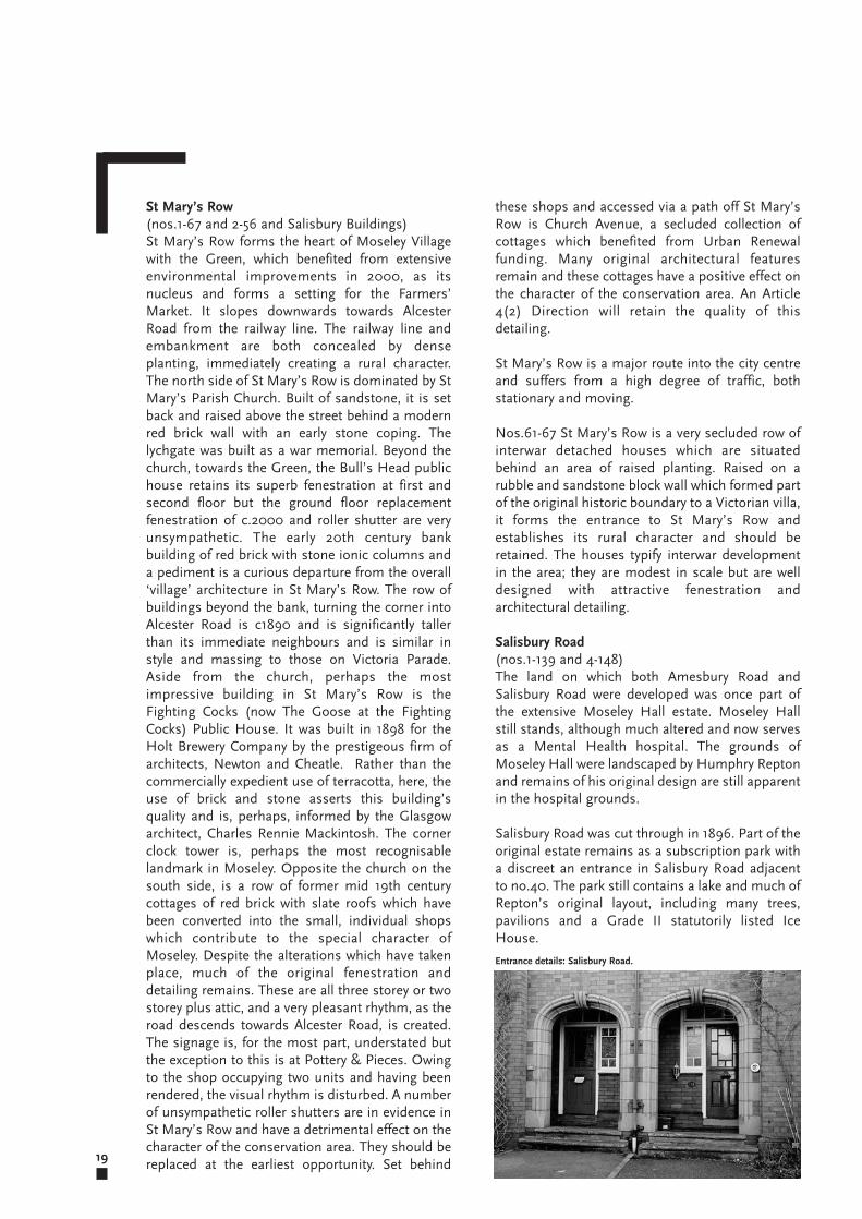
Salisbury Road(nos.1-139 and 4-148) The land on which both Amesbury Road andSalisbury Road were developed was once part ofthe extensive Moseley Hall estate. Moseley Hallstill stands, although much altered and now servesas a Mental Health hospital. The grounds ofMoseley Hall were landscaped by Humphry Reptonand remains of his original design are still apparentin the hospital grounds.
Salisbury Road was cut through in 1896. Part of theoriginal estate remains as a subscription park witha discreet an entrance in Salisbury Road adjacentto no.40. The park still contains a lake and much ofRepton’s original layout, including many trees,pavilions and a Grade II statutorily listed IceHouse.
St Mary’s Row(nos.1-67 and 2-56 and Salisbury Buildings)St Mary’s Row forms the heart of Moseley Villagewith the Green, which benefited from extensiveenvironmental improvements in 2000, as itsnucleus and forms a setting for the Farmers’Market. It slopes downwards towards AlcesterRoad from the railway line. The railway line andembankment are both concealed by denseplanting, immediately creating a rural character.The north side of St Mary’s Row is dominated by StMary’s Parish Church. Built of sandstone, it is setback and raised above the street behind a modernred brick wall with an early stone coping. Thelychgate was built as a war memorial. Beyond thechurch, towards the Green, the Bull’s Head publichouse retains its superb fenestration at first andsecond floor but the ground floor replacementfenestration of c.2000 and roller shutter are veryunsympathetic. The early 20th century bankbuilding of red brick with stone ionic columns anda pediment is a curious departure from the overall‘village’ architecture in St Mary’s Row. The row ofbuildings beyond the bank, turning the corner intoAlcester Road is c1890 and is significantly tallerthan its immediate neighbours and is similar instyle and massing to those on Victoria Parade.Aside from the church, perhaps the mostimpressive building in St Mary’s Row is theFighting Cocks (now The Goose at the FightingCocks) Public House. It was built in 1898 for theHolt Brewery Company by the prestigeous firm ofarchitects, Newton and Cheatle. Rather than thecommercially expedient use of terracotta, here, theuse of brick and stone asserts this building’squality and is, perhaps, informed by the Glasgowarchitect, Charles Rennie Mackintosh. The cornerclock tower is, perhaps the most recognisablelandmark in Moseley. Opposite the church on thesouth side, is a row of former mid 19th centurycottages of red brick with slate roofs which havebeen converted into the small, individual shopswhich contribute to the special character ofMoseley. Despite the alterations which have takenplace, much of the original fenestration anddetailing remains. These are all three storey or twostorey plus attic, and a very pleasant rhythm, as theroad descends towards Alcester Road, is created.The signage is, for the most part, understated butthe exception to this is at Pottery & Pieces. Owingto the shop occupying two units and having beenrendered, the visual rhythm is disturbed. A numberof unsympathetic roller shutters are in evidence inSt Mary’s Row and have a detrimental effect on thecharacter of the conservation area. They should bereplaced at the earliest opportunity. Set behind
Entrance details: Salisbury Road.
the Church. On the east side are three storey townhouses which have been converted to commercialuses. Beyond the conservation area boundary, onthe east side, the Meteor Ford garage site providesa notable terminating feature to the conservationarea. Any future development on this site will havea significant effect on the character of theconservation area and should be very carefullyconsidered in this context.
In the opposite direction, the City Centre is clearlyvisible as the road descends gently from the trafficlights. The houses in the lower part of SalisburyRoad were built in the Edwardian, Interwar andPost War periods. There is a combination ofdetached and semi detached, two and three storeyproperties with a variety of architectural styles.However, all follow a consistent building line whichmarks the curve of the road and all boast long reargardens and, consistent with the Moseleycharacter, mature trees and planting. Many of theearlier properties are built in an Arts and Craftsstyle of red brick with stone or terracotta dressings.They originally had boundary walls made fromsandstone blocks. An original wall may be seen atno.126. The interwar properties are individuallydesigned in a modified Arts and Crafts or mockTudor style using rendered brick and timberwork.All would have had simple wooden fences as atno.94. However, most boundaries have beenreplaced with modern low walls of stone,reconstituted stone or brick. The post War houseswere built in the 1950s and, despite beingdetached, are much more modest in design andmaterials. Salisbury Close is a small cul de sac offlats which backs onto Moseley Park. It was built inthe 1960s/70s and is set back from the road,having little impact on the character of theconservation area.
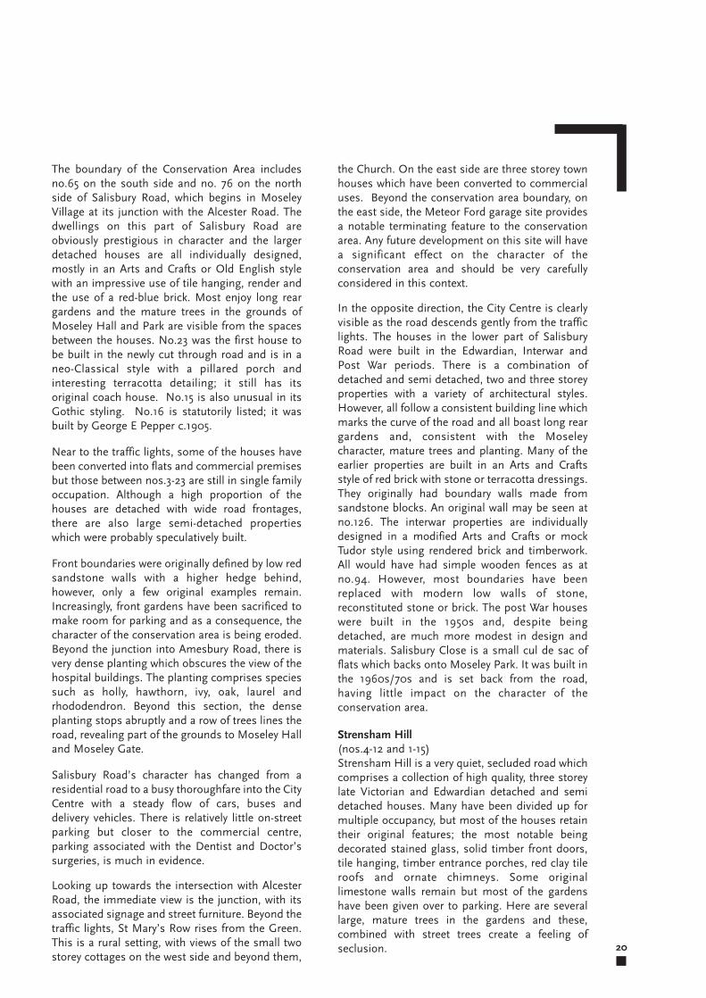
Strensham Hill(nos.4-12 and 1-15)Strensham Hill is a very quiet, secluded road whichcomprises a collection of high quality, three storeylate Victorian and Edwardian detached and semidetached houses. Many have been divided up formultiple occupancy, but most of the houses retaintheir original features; the most notable beingdecorated stained glass, solid timber front doors,tile hanging, timber entrance porches, red clay tileroofs and ornate chimneys. Some originallimestone walls remain but most of the gardenshave been given over to parking. Here are severallarge, mature trees in the gardens and these,combined with street trees create a feeling ofseclusion. 20
The boundary of the Conservation Area includesno.65 on the south side and no. 76 on the northside of Salisbury Road, which begins in MoseleyVillage at its junction with the Alcester Road. Thedwellings on this part of Salisbury Road areobviously prestigious in character and the largerdetached houses are all individually designed,mostly in an Arts and Crafts or Old English stylewith an impressive use of tile hanging, render andthe use of a red-blue brick. Most enjoy long reargardens and the mature trees in the grounds ofMoseley Hall and Park are visible from the spacesbetween the houses. No.23 was the first house tobe built in the newly cut through road and is in aneo-Classical style with a pillared porch andinteresting terracotta detailing; it still has itsoriginal coach house. No.15 is also unusual in itsGothic styling. No.16 is statutorily listed; it wasbuilt by George E Pepper c.1905.
Near to the traffic lights, some of the houses havebeen converted into flats and commercial premisesbut those between nos.3-23 are still in single familyoccupation. Although a high proportion of thehouses are detached with wide road frontages,there are also large semi-detached propertieswhich were probably speculatively built.
Front boundaries were originally defined by low redsandstone walls with a higher hedge behind,however, only a few original examples remain.Increasingly, front gardens have been sacrificed tomake room for parking and as a consequence, thecharacter of the conservation area is being eroded.Beyond the junction into Amesbury Road, there isvery dense planting which obscures the view of thehospital buildings. The planting comprises speciessuch as holly, hawthorn, ivy, oak, laurel andrhododendron. Beyond this section, the denseplanting stops abruptly and a row of trees lines theroad, revealing part of the grounds to Moseley Halland Moseley Gate.
Salisbury Road’s character has changed from aresidential road to a busy thoroughfare into the CityCentre with a steady flow of cars, buses anddelivery vehicles. There is relatively little on-streetparking but closer to the commercial centre,parking associated with the Dentist and Doctor’ssurgeries, is much in evidence.
Looking up towards the intersection with AlcesterRoad, the immediate view is the junction, with itsassociated signage and street furniture. Beyond thetraffic lights, St Mary’s Row rises from the Green.This is a rural setting, with views of the small twostorey cottages on the west side and beyond them,
21
Woodbridge Road (nos.2-46 and 1-43)Only the section from the railway bridge to AlcesterRoad falls within the conservation area. It is a wideroad with two semi-mature trees at the rear ofLloyds Bank. Woodbridge Road is used as a meansof gaining access to Wake Green Road, bypassingMoseley village centre and there is some stationaryand moving traffic. Owing to the proximity of theshops, there is also a significant amount ofpedestrian activity. The buildings arepredominantly of red brick with slate roofs. Somefrontages are at the back of pavement, others areset back behind brick walls and timber fences. Thehouses date from the mid 1860s and boast brickarches above ground floor doors and windows.Some fine original fanlights remain. An UrbanRenewal Scheme in the 1970s provided timberimitation sash windows, replacement chimneysand artificial slate roofs.
Nos.24 to 32 is a terraced housing development byAngelo Burratti designed by local architects BrophyAssociates and was completed c2000. It fits wellinto the street scene and replaces the MidlandCounties Dairy.
The Woodbridge Garage built c1940 retainsoriginal first floor metal windows. It has a neutralimpact on the character of the conservation area,contributing to the activity of the street.
The Police station was built c1980. It is simplydetailed and built with good quality materials. Theforecourt is attractively landscaped with matureshrubs and trees.
The Patrick Kavanagh bar (previously the TrafalgarHotel) was purpose built as a hotel in the 1880s.Nearly all of the original details remain includingpolychromatic brickwork, external joinery, etchedglass to advertise the first floor billiard room,leaded lights to ground floor bar areas and thefascia. Designed as a corner landmark building, itremains the most distinctive in the road.
A recent extension to the Kababish Restaurant hasincreased the footprint over the corner of thepavement; although this was undertaken withconsent, it does not preserve or enhance thecharacter of the conservation area.
Trafalgar Road(nos.116-142 and 121-149)Trafalgar Road runs north-south off WoodbridgeRoad. The conservation area extends to andincludes no.121 on the east side and no.116 on thewest side. The houses are set back from the road,many behind front gardens bounded by low brickwalls which were constructed in the 1970s as partof an Urban Renewal Scheme. Some propertieshave given over their front gardens to parking. Thestreet is devoid of trees.
The majority of the houses date from the mid 19thto the early 20th century. The 2nd EditionOrdnance Survey of 1904 shows the road to havebeen completely developed. There is a combinationof semi detached and two and three storey terracedhouses of red brick with artificial slate roofs whichwere replaced under the Urban Renewal Scheme ofthe 1970s.
Much of the original fenestration has beenremoved and replaced with uPVC although many ofthe properties retain their attractive detailing.Nos.120 and 122 are semi detached houses ofc.1870 which retain many original features,including fenestration, bargeboards and doorsurrounds. Nos.125-129 is a terrace of three storeyhouses dating from c.1990.
Late Victorian houses: Strensham Hill.
the Moseley Park and Pool Company which wasinstrumental in safeguarding what remained of thePark, its landscape and its vistas.
In addition to the listed Hall, the hospital sitecontains a range of modern buildings. Some areunsympathetic and in poor repair and date fromthe 1960s and 1970s. The land was recontoured toaccommodate these late 20th century blocks andthe site retains its open aspect and containsmature trees and shrubs which screen the hospital.These buildings are situated mainly to the northand west of the Hall and comprise predominantlyflat roofed structures three storeys in height. Thesebuildings are arranged around a courtyard whichserves as the main entrance.
A planning application for the redevelopment ofthe southern part of the hospital site was approvedin December 2004. The application was challengedin August 2005 and a new application wassubmitted in July 2005. This was approved inDecember 2005. The new hospital extensioncomprises a three storey spine building situated onthe south side of the main entrance courtyard. Tothe rear of this block are six single storey wardsarranged in pairs and set at oblique angles partlyon the footprint of the existing modern buildings.They are linked to the main building by glazedcorridors. The new buildings are essentially flatroofed and clad in modern materials.
Although the development results in the loss ofsome existing open space, it retains the spaciouslandscaping fronting Amesbury Road. Theremaining Repton landscape fronting SalisburyRoad is unaffected.
22
Moseley Hall, Park and Pool
In the 1770s Moseley Hall and Park was owned bythe wealthy Taylor family who were responsible forcommissioning Humphry Repton’s landscapingscheme of the 1790s and carrying outimprovements to the Hall. The Hall was seriouslydamaged during riots in the 1790s and wasallegedly demolished and rebuilt. The Hallremained the home of the Taylor family until the1860s when it was leased to tenants.
At around this time, the decision was made to selloff parts of the Park for development; Park Hill wassubsequently cut, followed by Chantry Road andSalisbury Road. However, development pressuresinitiated the establishment in 1899 of the MoseleyPark and Pool Company, originally comprising agroup of residents who were opposed to furtherdevelopment of the Park. The Company leasedfourteen acres of parkland for leisure use forprivate members until 1959 when an additionaleleven acres were purchased.
The history of the development of Moseley Hall,Park and Pool is detailed in the Historic LandscapeManagement Plan, commissioned from ParklandsConsortium.
Moseley HospitalMoseley Hall Hospital occupies a site of abouteight acres and is bounded by residentialdevelopment. The original Hall is a three-storeyashlar building dating from 1795 and is statutorilylisted Grade II. The hospital buildings are situatedin landscaped parkland which originally formedpart of extensive grounds laid out by HumphryRepton. The grounds also contain two other listedbuildings, the Dovecote and the Cow House. Bothare listed Grade II.
The last of the tenants of the Hall was RichardCadbury who leased it from 1883 until hepurchased it in 1890. A year later he converted theHall into a convalescent home for sick children. Itwas the combined effort of Richard Cadbury and
8Part A
Trees, Hedges and Walls
23
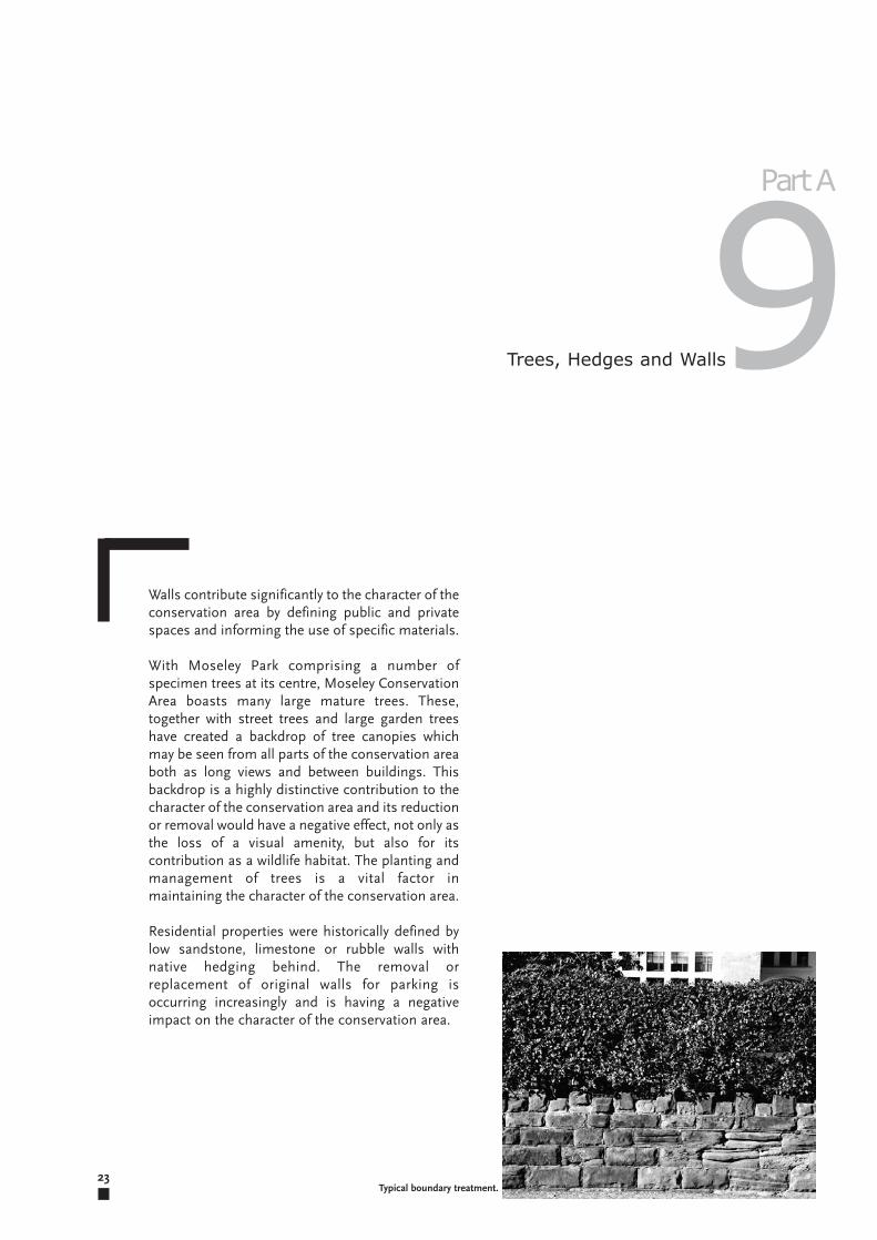
Walls contribute significantly to the character of theconservation area by defining public and privatespaces and informing the use of specific materials.
With Moseley Park comprising a number ofspecimen trees at its centre, Moseley ConservationArea boasts many large mature trees. These,together with street trees and large garden treeshave created a backdrop of tree canopies whichmay be seen from all parts of the conservation areaboth as long views and between buildings. Thisbackdrop is a highly distinctive contribution to thecharacter of the conservation area and its reductionor removal would have a negative effect, not only asthe loss of a visual amenity, but also for itscontribution as a wildlife habitat. The planting andmanagement of trees is a vital factor inmaintaining the character of the conservation area.
Residential properties were historically defined bylow sandstone, limestone or rubble walls withnative hedging behind. The removal orreplacement of original walls for parking isoccurring increasingly and is having a negativeimpact on the character of the conservation area.
9Part A
Typical boundary treatment.
24The Green

25
Moseley
Conservat ion Area
Part B
Management P lan
26The Post Office - Alcester Road
27
OBJECTIVE 1Policies for the control of new development toenhance the area, including new development.
Local Planning Policy and Guidance
Regeneration through Conservation:Birmingham Conservation Strategy 1999.
Conservation Areas and Listed Buildings: Aguide for owners and occupiers 2003.
Archaeology Strategy 2004.
Places for Living 2001.
Mature Suburbs Draft Interim SPG 2005.
The Moseley Village Action Plan.The Moseley Village Action Plan was prepared in1992 by the City Council after extensive discussionswith local interested parties who were concernedabout the gradual decline of Moseley shoppingcentre. It has been adopted as SuplementaryPlanning Guidance.
It explored a range of issues and put forwardproposals to:
“Retain and enhance the unique character of Moseleyas a conservation area.
Identify opportunities for environmental enhancementand improvement to the physical condition of thebuildings.
Guide future development in the shopping area.
Bring upper storeys of shopping units back intoprofitable use through identifying opportunities for“Living above the Shop”.
Address parking and service requirement.
Control the further spread of hostels and institutionaltype uses.
Identify priorities and seek to attract finance for futureinvestment.
Identify broad transport objectives.”
The guidance contained within the MoseleyConservation Area Management Plan is intendedto preserve or enhance the character andappearance of the conservation area and assist inmanaging change without compromising thehistoric environment. Moseley combines aresidential mix, ranging from significant architect-built houses to modest terraced housing and avibrant commercial centre. It is vital to preserveand enhance the historic integrity of theconservation area as a whole.
KEY OBJECTIVESPolicies for the control of new development toenhance the area including commercialdevelopment.
To control small scale changes including streetfurniture and parking.
The removal of Permitted Development bymeans of an Article 4(2) Direction.
Implementation of other policies to conformwith National Legislation.
Management Plan1Part B
1
2
3
4
�
�
�
�
�
�
�
Moseley Park and Pool - Historic LandscapeManagement Plan
Moseley Park and Pool Company commissioned areport from Parklands Consortium Ltd. Regardingthe condition of Moseley Park, it is intended toform the basis of a restoration programme in thePark.
OBJECTIVE 2Policies to control small scale changes.Protection and enhancement of the historicenvironment.
Enhancement opportunities exist at the junctionwith St. Mary’s Row, Alcester Road and SalisburyRoad, outside Victoria Parade. Here the signage,street furniture and paving have accumulatedover several years in an ad hoc manner. Aconsistent approach to design and materialswould enhance the conservation area. All shouldbe assessed and reduced to an absoluteminimum when the opportunity arises.
Moseley is partly characterised by small,independently run shop units. Opportunitieswill be taken to secure funding via the Council’sCapital Programmes and the negotiation of 106Agreements. The restoration or reinstatement oftraditional shopfronts would have a positiveeffect on the conservation area. Shop signageis, in some cases, oversized and excessive andefforts should be made to reduce its impact.
Both sides of the road in Park Hill have a verystrong sense of enclosure; additionallandscaping at St. Anne’s Church wouldenhance its setting.
Additional hedging around Moseley HallHospital Training Centre in Amesbury Roadwould provide an increased sense of enclosureand would enhance that part of Amesbury Road.
Reinstatement of original features will beencouraged as a positive measure to preserve orenhance the character of the conservation area.
On-street parking and parking on pavements inMoseley, especially around the traffic lights,have a negative effect on the character of theconservation area; efforts should be made toreduce this to a minimum.
At other locations, for example, at the carpark onAlcester Road and at The Village public housewould benefit from additional landscaping andwould enhance the character of the conservationarea.
28
It states that: “all proposals for development,including a change of use … should recognise thespecial character of the existing commercial areawhich is wholly contained within the conservationarea”.
Policy for non Retail Uses in Moseley 1999.A policy for non Retail Uses in Moseley Village wasadopted by the Development Control Committee in1999. This Policy sought to halt changes of use toA3 uses (cafes, restaurants, hot food take-awaysand pubs) and A2 uses (banks, building societiesand financial services). A review of this policy wasundertaken in July 2004 and the continuation ofthe Policy for non Retail Uses in Moseley wasrecommended.
The policies have constituted SupplementaryPlanning Guidance since 1999.
The BirminghamUnitaryDevelopment Plan 2005The statutory planning framework for Moseley iscontained in the UDP. Its main policy objective isto improve the quality of Birmingham’senvironment through planning policies and urbandesign.
The UDP acknowledges that conservation areas:“provide a powerful means of preserving the best ofour historical and architectural heritage”.
A number of the issues raised in the UDP havebeen achieved, including:
Reviewing the conservation area boundary and givingconsideration to an Article 4(2) Direction.
Seeking statutory protection and local listing forbuildings and gardens within the conservation area.
Implementing a landscaping scheme at the Green.
Environmental enhancement at the Parade.
Policies also include:
Presumption against non-family dwelling uses.
The provision of high quality specialist commercialuses.
Shopfront Design Guide 1995The Shopfront Design Guide was written with theaim of encouraging high standards of design andprovide consistent guidelines against whichplanning applications may be considered.
Moseley Shopfront Design Guide 1992This is the result of an initiative by the MoseleySociety to document good practice for shopfrontrenovation.
�
�
�
�
�
�
�
�
�
�
�
�

29
Historical Research/RecordingThe Council will require historical documentaryresearch or recording to be carried out whenproposals for alteration or demolition will affect thecharacter or appearance of the building or theconservation area.
Moseley ParkThe Moseley Park and Pool Company hascommissioned a full historical, arboricultural,ecological and hydrological study of Moseley Parkfrom Parklands Consortium Ltd. Proposals for therestoration of the Park will form the basis of theManagement Plan and any restorationprogrammes in the park which should respect thehistoric Repton landscape.
New DevelopmentAny new development must preserve or enhancethe character and appearance of the conservationarea, it will respect the values contained in theConservation Area Appraisal and ManagementPlan and Government and other City Councilguidelines. It will respect the scale, massing,materials of the traditional buildings within theconservation area. Existing and historic buildinglines will be respected and principal elevationsshould front the street. There will be a presumptionagainst development on existing rear gardens.
PavingWhere paving is in need of renewal it will bereplaced with materials which preserve or enhancethe character of the conservation area. Thereshould be a coherent approach to design andmaterials.
Repair and MaintenanceThe Council will provide guidance on materials,techniques and finishes which will preserve orenhance the buildings and conservation area.
SecurityWhilst acknowledging the need for security,especially on commercial premises, the Councilwill not normally permit externally mounted orsolid shutters. Shutters should be semitransparent, and alarm boxes, security lighting,CCTV cameras etc should be placed asunobtrusively as possible. Policies contained inthe Shopfront Design Guide will be complied with.
AlterationsThere will be a presumption against alterations tobuildings which adversely affect their character andappearance or that of the conservation area.
Boundary WallsThe removal or partial removal of boundary wallswill not be permitted. Replacement walls will bebuilt using traditional materials such as limestone,sandstone or reconstituted stone of a suitabledesign. Brick walls will not normally be acceptable.
Car ParkingIn those areas which are covered by the Article 4(2)Direction, the Council will require a planningapplication for the development of carparkingspaces where this involves the demolition or partialdemolition of buildings or boundary walls. In areasnot affected by the Article 4 (2) Direction, asensitive approach will be employed to safeguardthe character and appearance of the conservationarea.
Change of UseThe Policy for non Retail Uses in Moseley (SPG1999) will be employed.
DemolitionThe Council will not normally permit thedemolition of buildings in Moseley ConservationArea unless the building to be demolished can beshown to have a negative effect on the character ofthe conservation area.
External AdvertisingMoseley has a number of small individual shopswhich generates the requirement for a largeamount of signage. Projecting box signs, oversizedfascias and internally illuminated signs will not bepermitted; policies contained in the ShopfrontDesign Guide should be adhered to in order topreserve or enhance the character of the buildingand that of the conservation area. Opportunities toreplace inappropriate signage will be taken as theyarise.
HedgesNew and replacement hedge planting will beencouraged where appropriate. The type ofplanting should be sympathetic to the specificlocation and is to be agreed with Tree Officers. Anyadditional planting should reinforce the characterof the conservation area.
treatment, perhaps insignificant as individualalterations, have taken place throughout theconservation area under Permitted Development.The cumulative effect of these alterations togetherwith the removal of other architectural details suchas chimneys, ridge tiles, tile hanging, decorativeironwork and stained glass has a negative effect onthe character of the conservation area. In order toprevent further erosion of the character of certainresidential roads where a degree of high qualityoriginal features remain, some permitteddevelopment rights have been removed by meansof placing an Article 4(2) Direction on AmesburyRoad (nos. 2-46 and no.41), Chantry Road (nos.4-64 and (5-69), Church Avenue (nos. 1-12), Park Hill(nos.10-128) and (nos.5-7, 11-45) and SalisburyRoad (nos.3-23, 59-65 and 4-76).
These roads encapsulate the high architecturalquality which defines Moseley Conservation Areaand set a standard which should inform futuredevelopment and alteration within theconservation area.
The Town and Country Planning (GeneralPermitted Development Order) 1995, Article 4brings certain categories of permitted developmentwithin planning control, requiring planningpermission to be obtained for minordevelopments. The planning fee is waived in thesecircumstances.
Alterations requiring planning permission underthe Article 4(2) Direction:Part 1: Development within the curtilage of adwellinghouse.
The enlargement, improvement or otheralteration of a dwellinghouse (This includes theinstallation and alteration of doors and windowsand the erection of porches or other extensions).
The enlargement of a dwellinghouse consistingof an addition or alteration to its roof (Thisincludes alteration or removal of chimneys, theinstallation of rooflights and any change ofmaterials).
The erection or construction of a porch outsideany external door.
The provision of a hard surface (This includesthe creation of a hard surface for the provision ofparking).
The installation, alteration or replacement of asatellite antenna.
30
ShopfrontsNew or replacement shopfronts will comply withthe Shopfront Design Guide and MoseleyShopfront Design Guide and will be designed so asto preserve or enhance the building andconservation area. The traditional shopfronts willbe retained and opportunities to reinstatetraditional shopfronts will be taken as they arise.
Street FurnitureLamp columns, litterbins, information panels andother street furniture will be kept to an absoluteminimum. Street furniture should be of aconsistent design so as to enhance theconservation area.
TreesThe Council will require detailed tree surveys ofprospective development sites and, where trees areto be retained in new developments, proposalsdemonstrating that the trees will be suitablyprotected from damage during construction will berequired. The Council will require landscaping,including tree and hedge planting to a highstandard.
If a preserved tree dies of natural causes, has to befelled due to its dangerous condition or isdestroyed illegally, a replacement tree is a statutoryrequirement by law at the discretion of the Council.Any replanting should be of an appropriate specieswhich respects the historical context and size ofplot. The size, species and location of replacementtrees will be at the discretion of the Tree Officer. Allwork will be undertaken by qualified contractor.Significant views of trees should be retained.
Views Into and Out Of the Conservation AreaEvery effort should be made to preserve or enhancesignificant views into and out of the conservationarea.
OBJECTIVE 3Policies to remove permitted developmentAn Article 4 (2) Direction applies to residentialproperties only and removes permitteddevelopment rights from any part of thedwellinghouse which fronts onto a highway,waterway and open space. These will include frontand, sometimes, side and rear elevations ofproperties.
Alterations such as the installation of replacementdoors, windows and porches, the creation of hardstandings and the removal of original boundary
�
�
�
�
�

31
Planning Policy Statement 6 (PPS6): Planningfor Town Centres.
Planning Policy Guidance Note 13 (PPG13):Transport.
Conservation Area Practice. English HeritageGuidance on the Management of ConservationAreas. English Heritage 1995.
Conservation Area Appraisals. Defining thespecial architectural or historic interest ofConservation Areas. English Heritage 1996.
Alcohol Consumption in Designated PublicPlaces Regulations 2001.
Moseley Conservation Area Article 4(2)Direction. Advice Guide 2005.
Part 2: Minor operations.
The erection, construction, maintenance,improvement or alteration of a gate, fence, wallor other means of enclosure.
The formation of a means of access to ahighway.
The painting of the exterior of any building (Thisis intended to ensure that render and exteriorpaintwork is painted with colours which willpreserve or enhance the character of theconservation area. The painting of woodworkwill not require consent).
OBJECTIVE 4Other policies designed to conform with NationalLegislation.
The policies contained in this Management Planaccord with;
Government Planning Policy Notes andBirmingham City Council’s UDP.
The Mangement Plan also reflects the values ofPower of Place - The future of the historicenvironment - produced for Government in 2000by English Heritage.
It is also intended to complement the MoseleyConservation Area Character Appraisal.
Legislation and Guidance.
Planning (Listed Buildings and ConservationAreas) Act 1990.
Town and Country Planning Act 1990 (Part viii).
Town and Country Planning (Trees) Regulations1999.
Planning and Compensation Act 1991 (Section23).
Ancient Monuments and Archaeological AreasAct 1979.
National Heritage Act 1983.
Planning Policy Statement 1 (PPS 1): DeliveringSustainable Development.
Planning Policy Guidance Note 15 (PPG 15):Planning and the Historic Environment.
Planning Policy Guidance Note 16 (PPG 16):Archaeology and Planning.
Planning Policy Statement 9 (PPS 9):Biodiversity and Geological Conservation.
�
�
�
�
�
�
�
�
�
�
�
�
�
�
�
�
�
�
�
The Parish Church of St Mary, St Mary’s Row.Grade ll.The first church on the present site was built in theearly 16th century.
The tower was begun in 1496 but stood unfinishedfor many years. In the late 18th century the exteriorsandstone had crumbled to such a degree that thechurch had to be encased in brick. It was enlargedin 1823 and again in 1870 and almost completelyrebuilt in 1909.
St Anne’s Church, Park Hill. Grade ll.Built in 1872 by architect Frederick Preedy andfunded by Miss Rebecca Anderton. The churchsuffered from storm damage in 1939 and 1945 andwas extensively damaged in 1940.
The Dovecote, Alcester Road. Grade ll.Dates from c18th century, it is a brick constructionwith a tiled roof with a wooden lantern and finialand is octagonal in form. Three storeys in height,the top storey has a blank round headed arch toone side.
The Cow House, Alcester Road. Grade ll.C18th. B; slate roof. Single storeyed building ofuncertain use. Two blocked segmental arches.Brick detail eaves cornice.
The Ice House, Moseley Park. Grade ll.An 18th century subterranean brick structure with adomed brick chamber about 16 feet deep and 12feet in diameter. It has a brick vaulted entrancewith a right angled bend.
32
Appendix A: Statutorily and Locally Listed Buildings
Statutorily Listed Buildings
Moseley Hall. Grade ll.The first Moseley Hall stood to the north of StMary’s Church. The Hall on its present site was setin extensive grounds and was built by the Grevis(also spelt Greves and Graves) family in the late1790s.
The Hall boasted its own fishponds, an icehouseand a dovecote; all of which are still in existence.The Hall, Dovecote, Cow House and Ice House areall statutorily listed. In 1764, wealthy industrialistand co founder of Lloyd’s Bank, John Taylor, boughtthe Hall as a residence for his relatives. His son,John Taylor II, built a new hall in 1780, which burntdown during riots in 1791 and was rebuilt in 1792-6by architect John Stanbridge of Warwick. Theirdescendants continued to live there until JohnTaylor’s death in 1852 when the house wasoccupied by servants until William Dawes rentedthe property the late 19th century.
Richard Cadbury initially leased Moseley Hall in1884 and bought it in 1890 and in 1891 the decisionwas taken to convert The Hall into a convalescenthome for children when it became known asMoseley Hall Convalescent Hospital for Children.The Cadbury family built “Uffculme” inQueensbridge Road and took up residence in 1891.
When Salisbury Road was cut, effectively severingMoseley Hall from its parkland, concern for thefuture of the pool, prompted a group ofbusinessmen to form the Moseley Park and PoolEstate Co. It was, and still is, a private park for localresidents for a small annual fee.
A
33
Locally Listed Buildings
Prince of Wales PHAlcester Road
30 Chantry Road
NB. Consideration will be given to the inclusion ofno.2 Forest Road in the Local List of Buildings.
16 Salisbury Road. Grade ll.Originally known as The Turret, no doubt becauseof the octagonal structure which surmounts theright hand bay at the front of the house. It was builtabout 1905, somewhat later than adjacent housesin the road, possibly on land which previouslyformed a driveway giving access to Moseley PrivatePark behind and was designed in an Arts and Craftsstyle in brick with stone dressings with Voyseyinfluenced brackets beneath the conical roof abovethe turret. It retains its original front door andstained glass windows. There is an interestingportcullis design around the front door withbattlements at roof level. The architect was GeorgeE Pepper.
59 Salisbury Road. Grade ll.A substantial Arts and Crafts house raised on abanked garden at the corner of Amesbury Road,this house was built in 1897 by Joseph Crouch andEdmond Butler. It is an asymmetrical design in redbrick with an off-centre three storey entrance towerwith stone dressings and crenellations rising flushwith the wall and overhanging eaves.
4 Amesbury Road. Grade ll.A large house built in 1909 in the Arts and Craftsstyle, of red brick with some purple headers anddiaper work, this two storey house is symmetricalwith gabled wings. There are lofty chimney stacksto the front and rear and a tiled roof.
The Fighting Cocks PH. Alcester Road. Grade ll.Built 1899-1903 by Newton and Cheatle. Anoctagonal clock tower, simplified Jacobean mulliontransom fenestration with Arts and Crafts details,deep semi circular hoods to doorways. Clock faceshave scrolled surrounds of strapwork and there isalso a barometer at street level.
98 Alcester Road. Grade ll.Built 1830-40 in a plain, late Georgian style in redbrick with a hipped slate roof and with somemoulded stucco details. There is a modern wing tothe right hand side.
Pitmaston, Mooor Green Lane. Grade ll.Built 1930-31 by Holland W Hobbiss as a companyheadquarters for the Ideal Benefit Society. Brickwith pantile hipped roofs, wooden sash windows,stone entrance porch. T-shaped in plan in arestrained symmetrical neo-Classical style.
34
Appendix B: Archaeology
Birmingham City Council: Historic Buildings, Sites and Monuments Record
SMR Site Name Record
20745-BI2399 FEATURES NEAR MOSELEY HALL MonumentBrick walls and pebble track exposedSP 07482920745 Brick-built features, including walls and ash-filled hollow, and pebble trackway exposed near dovecoteand cowhouse.<1>
02166-BI443 COW HOUSE, MOSELEY MonumentBuilding to the NE of the Dovecote at Moseley Hall Hospital. C18. Brick, slate roof. Single-storeyedBUILDING 18th Century - 1700 AD to 1799 AD EXTANTSP 075829
02166 Building to the NE of the Dovecote at Moseley Hall Hospital. C18. Brick; slate roof. Single- storeyedbuilding of uncertain use. Two blocked segmental arches. Brick dentil eaves cornice. <1> Last evaluated12/3/84, satisfactory condition. Repair work carried out at same time as dovecote restored by MoseleySociety. Possibly contemporary with dovecote, or possibly later. Little archaeological interest or potentialexcept as a building. No evidence for earlier structures on site.
20622-BI2275 AUGUSTA ROAD CRUCIBLES Find SpotCrucibles alongside garden wall Ownership - Private ownerFINDSPOT Post Medieval - 1540 AD to 1900 ADSP 07448377
20622 Site visited following notification from owner. Crucibles alongside wall in garden. Complete crucibles380mm high, 230mm wide, max thickness 25mm. Crucibles have pouring lip and spillage down sides. Somelids. Also, some glassy slag pieces and base of basin with green glaze on both sides. Basin 70mm thick,possibly 400mm diameter
02981-BI863 OLD MOSELEY HALL MOAT MonumentMoated site at Old Moseley Hall, King’s Norton (? highly likely to possible) No 119.
Medieval - 1066 AD to 1539 AD SP 077833 02981 Moated site at Old Moseley Hall, King’s Norton (? highly likely to possible) No 119. <1> The above sitingfalls within an area largely developed with C19 housing. The pond within Moseley Park 350m W of the siting,is an old flooded quarry.
20639-BI2292 MOSELEY VILLAGE MonumentSP 077831
B
Appendix C: Background Reading
35
The Conservation Strategy‘Regeneration Through Conservation’Birmingham City Council, 1999.
The Moseley Village Action PlanBirmingham City Council/The Moseley Society,1992.
The Birmingham Unitary Development Plan(Deposit Draft 2001) Birmingham City Council.
The Moseley Shopfront Design GuideBirmingham City Council/The Moseley Society,1992.
Historic Landscape Management PlanParklands Consortium, 2004.
Policy for Non-retail Uses in MoseleyBirmingham City Council, 1999.
Unpublished research provided by members ofthe Moseley Society.
A History of MoseleyAlison Fairn, 1973. BRL.
A History of MoseleyAlison Fairn, 2004. 600 Celebrations Committee.
Moseley, Balsall Heath & HighgateM Baxter & P Drake, 1996. BRL.
MoseleyJohn Morris Jones, 1981. BRL.
Victoria County Historyvol vii 1953. BRL.
Birmingham DirectoriesBRL.
Birmingham RegistersBRL.
Blood’s Plan of Birmingham1857. BRL.
Ordnance Survey Maps1st-4th Editions, c1889-1936. BRL.
Tithe MapKing’s Norton Parish, 1840. BRL.
C

Most Birmingham City Councilpublications can be made availablein alternative formats or languages.
If you have difficulty reading thisdocument please call us on (0121)303 1115 to ask if a full or summaryversion can be made available inlarge print, another format oranother language.
If you have hearing difficultiesplease call us via Typetalk 180010121 303 3030.
Or e-mail us at:[email protected] 36
Contact and Further Information
Contact
Conservation TeamPlanningAlpha TowerSuffolk Street QueenswayBirminghamB1 1TU
Tel: (0121) 303 1115E-mail: [email protected]
Further Information
For further copies and guidance aboutconservation and listed buildings visit our website:
www.birmingham.gov.uk/conservation
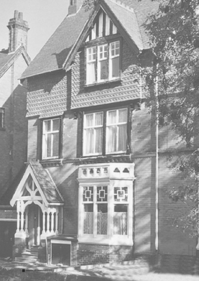
Houses on Strensham Hill

Moseley
Conservat ion Area
March 2005
Character Appra isa l and
Management P lan