morris canal greenway feasibility study
DESCRIPTION
The Passaic County Planning Department just completed a Feasibility Study to create a Greenway along the Morris Canal Historic District, through the municipalities of Clifton, Little Falls, Paterson, Pompton Lakes, Wayne, and Woodland Park.TRANSCRIPT

MORRIS CANAL GREENWAY FEASIBILITY STUDYPASSAIC COUNTY PLANNING DEPARTMENT - JUNE 2011
Cable Lift Bascule Bridge with Curved-Track Rolling Counterweight at Mountain View Township of Wayne
Morris Canal Park & Nature PreserveCity of Clifton
Ramapo River Towpath, Pompton Aquatic ParkTownship of Wayne
Proposed Morris Canal Greenway RoutePassaic County

Morris Canal Greenway Feasibility Study Page 2
Passaic County Morris Canal Greenway Feasibility StudyTable of Contents
1.� Project Purpose .......................................................................................................... 6�1.1� Project Goals and Objectives .......................................................................... 6�
2.� Project Context .......................................................................................................... 6�2.1� History ............................................................................................................. 6�2.2� Geography ....................................................................................................... 9�
3.� Proposed Morris Canal Greenway ......................................................................... 10�3.1� Pedestrian and Bicycle Paths ....................................................................... 12�
3.1.1� Walkway Paths ................................................................................... 12�3.1.2� Bicycle Paths ..................................................................................... 13�
4� Land Use Inventory ................................................................................................. 13�4.1� Public Lands (including Open Space and Community Facilities) ............. 14�
4.1.1� Public Parks and Open Spaces .......................................................... 14�4.1.2� Other Public Facilities ...................................................................... 16�
4.2� Environmentally Sensitive Land and Resources Inventory ........................ 17�4.2.1� 2007 Land Use/Land Cover Inventory .............................................. 17�4.2.2� Flood Plains Inventory ...................................................................... 20�4.2.3� Environmentally Sensitive Protected Lands ...................................... 24�
4.3� Historic Districts and Historically Significant Land ................................... 25�4.4� Transportation Connectivity ......................................................................... 31�4.5� Economic Activity ......................................................................................... 32�
5� Site Selection Process ............................................................................................... 33�5.1� Selection Criteria .......................................................................................... 34�
5.1.1� Connectivity Factors .......................................................................... 35�5.1.2� Estimated Construction Costs for the Site ......................................... 35�5.1.3� Environmental Sensitivity .................................................................. 35�5.1.4� Safety Considerations ........................................................................ 36�5.1.5� Administrative Challenges ................................................................. 36�5.1.6� Historic Preservation ......................................................................... 36�5.1.7� Alternative Options ............................................................................ 36�
5.2� Summary of Site Findings ............................................................................ 37�5.3� Selected Specific Site Information ............................................................... 37�
5.3.1� Site 1: Dawes Highway Bridge south to Cole Street, Township of Wayne and Borough of Pompton Lakes ........................................ 38�
5.3.2� Site 2: Route 23 Overpass, Township of Wayne ................................ 39�5.3.3� Site 3: Haul Road Industrial Park, Township of Wayne ................... 40�5.3.4� Site 4: Mountain View Rail Area (Pompton Feeder
Connection), Township of Wayne ...................................................... 41�5.3.5� Site 5: Singac Brook Bridge, Township of Wayne ............................. 42�5.3.6� Site 6: Diversion over Interstate 80 and Route 46, Township of
Wayne and Borough of Totowa ......................................................... 43�5.3.7� Site 7: Greenway to Union Boulevard Connection (walkway to
bridge), Borough of Totowa .............................................................. 44�
Morris Canal Greenway Feasibility Study Page 3
5.3.8� Site 8: Little Falls Morris Canal Park (access and parking lot area), Township of Little Falls .......................................................... 45�
5.3.9� Site 9: Paterson Avenue south to Main Street, Township of Little Falls .......................................................................................... 46�
5.3.10� Site 10: Peckman Preserve Bridge, Township of Little Falls ............ 47�5.3.11� Site 11: Garden State Parkway Right-of-Way and Bridge, City
of Clifton ............................................................................................ 48�6� General Greenway Improvements ......................................................................... 49�
6.1� Trail Signage and Way Finding ................................................................... 49�6.2� Pedestrian and Bicycle Amenities ................................................................ 50�6.3� Property and Personal Safety Considerations ............................................. 52�6.4� Maintenance .................................................................................................. 53�
7� Funding ..................................................................................................................... 54�8� Conclusions ............................................................................................................... 62�9� List of Preparers and Participants ......................................................................... 64
Appendices
I.I Map of Proposed Morris Canal GreenwayI.II Historically Significant Land Identified Along the Proposed Morris
Canal Greenway I.III Public Feedback Garnered from Public Outreach Meetings

Morris Canal Greenway Feasibility Study Page 4
Acknowledgements:
Passaic County Board of Chosen Freeholders Terry Duffy Freeholder Director Deborah Ciambrone Deputy Director Greyson Hannigan, Esq. Freeholder Bruce James Freeholder Pat Lepore Freeholder Michael Marotta Freeholder Edward O'Connell Freeholder
Passaic County Planning Board Thomas Williamson Chair Joseph Metzler Deputy Chair Terry Duffy Freeholder Director Bruce James Freeholder Michael Marotta (alt.) Freeholder Miguel Diaz Commissioner William Gervens Commissioner Stephen Martinique Commissioner Vincent Olivo Commissioner Steven Edmond, PE County Engineer Michael La Place, AICP / PP Planning Director Lynda Wilson (alt.)
Passaic County Open Space and Farmland Preservation Trust Fund Advisory CommitteeGreyson Hannigan Freeholder Anthony DeNova County Administrator Michael J. Sebetich, Ph.D. Chairman Kathleen M. Caren Open Space Coordinator Phil Conroy County Naturalist Isabel Agudelo Humberto Cuadrado Raymond Egatz Geraldine Flach Sandra E. Lawson Carl Richko Patricia Rocca Thomas Sergi Alice A. Szepietowski Anne Tacinelli Michael La Place, AICP / PP Planning Director John Pogorelec, Jr. Assistant County Counsel
Morris Canal Greenway Feasibility Study Page 5
Acknowledgements continued:
Geraldine R. Dodge Foundation Passaic County Open Space Trust Fund Canal Society of New Jersey City of Clifton Township of Little Falls City of Paterson Borough of Pompton Lakes Township of Wayne Borough of Woodland ParkAssociation of New Jersey Environmental Commissions (ANJEC) Canal Society of New Jersey

Morris Canal Greenway Feasibility Study Page 6
1. Project Purpose
This feasibility study was prepared with a grant from the Association of New Jersey Environmental Commissions (ANJEC) and matching funds from the Passaic County Open Space Trust Fund. The primary purpose of this study is to determine how areas of open space can be connected to create a contiguous recreational trail along the historical route of the Morris Canal in Passaic County. The Morris Canal Greenway Feasibility Study will review the potential to preserve and restore open space while creating safe recreational opportunities for pedestrians and bicyclists throughout the County.
In addition, this project seeks to develop multimodal transportation routes, improve pedestrian accessibility to downtown centers, protect environmental sensitivity and sustainability, and promote cultural and heritage tourism within Passaic County.
Although this study attempts to be as comprehensive as possible, it is meant as a high-level planning document that proposes a route for the Morris Canal Greenway and identifies potentially problematic sites along the route. This study does not represent specific design-level infrastructure improvements or detailed site plans. It is anticipated that these types of efforts will come later, as the County begins to transform the Proposed Greenway into useable park space.
1.1 Project Goals and Objectives
The key objective of this study is to investigate whether a pedestrian-friendly pathway that follows the original Morris Canal and its Pompton Feeder, through Passaic County, is feasible from a physical land use perspective. To complete this goal, the study evaluates land use along the original Morris Canal right-of-way in terms of environmental, historical, and geographic conditions.
The final goal of this investigation is to identify and document a proposed Morris Canal Greenway route that is safe, contiguous and offers both Passaic County residents and visitors to the County a pedestrian and bicycle facility spanning the full length of the original Morris Canal in Passaic County.
2. Project Context
2.1 History
In the early 1820s, when inland transportation routes were sparse and commercial transportation was at a premium, Morristown businessman George P. Macculloch generated interest among New Jersey citizens and Governor Isaac Williamson for a canal spanning the entire width of New Jersey, from the Delaware River to the Passaic River in Newark. The legislature responded by creating the Morris Canal and Banking Company, which was tasked to construct a water highway of inclined planes and traditional lift locks from Phillipsburg to Newark. This 90-mile stretch was completed in 1831, followed by an 11.75-mile extension from Newark to Jersey City in 1836.
Morris Canal Greenway Feasibility Study Page 7
The Morris Canal, a world famous engineering marvel of its time, was known as the “mountain climbing canal.” It crossed the New Jersey Highlands, overcoming more elevation change than any other canal built in the world. Approximately two-thirds of the canal’s alignment extended through the Highlands as the waterway crossed northern New Jersey, connecting New York Harbor at Jersey City with the Delaware River at Phillipsburg. Its main line was approximately 102 miles long and was used for commercial transportation for nearly a century. The canal crossed through 36 municipalities in six counties: Hudson, Essex, Passaic, Morris, Sussex, and Warren (see Figure 1, page 9).
A system of 23 lift locks and 23 inclined planes enabled the canal to overcome an elevation change of 1,674 feet. The canal’s famous inclined planes were water-powered marine railways on which cradle cars carried canal boats up and down hillsides. The planes were employed to overcome the major changes in elevation for the Morris Canal.The locks operated similar to water elevators, allowing canal boats to traverse smaller changes in elevation. Mules towed the canal boats across the state on the five-day journey from Jersey City to Phillipsburg.
The canal’s inclined planes attracted engineers from around the world. Planes adapted from the Morris Canal were employed on canals in Japan, Poland and Nova Scotia. The Poland canal planes are still operating and are major tourist attractions.
Due to its location in the rugged terrain of the New Jersey Highlands, Morris County has the distinction of being the site of 13 of the Morris Canal’s 23 inclined planes and 13 of the canal’s 23 lift locks. Planes in Morris County overcame a total change of 824 feet in elevation; locks in the county overcame 115 feet of elevation change. Approximately 56% of the elevation change on the overall Morris Canal occurred within Morris County.The county also had the distinction of containing part of the canal’s largest water supply reservoir – Lake Hopatcong. Located at the highest elevation or “summit” of the canal, Lake Hopatcong’s waters flowed both eastward and westward into the canal, making navigation possible.
The Morris Canal’s manmade cross-section or “prism” consisted of the canal bed or channel and supporting embankments on either side. The channel was a 40-foot-wide navigable waterway that was five feet deep. A dirt-paved towpath paralleled the edge of the canal bed where teams of mules were led to tow the canal boats across the state. In its later years of operation, canal boats were approximately 90 feet long, built in two sections and had a capacity for 70 tons of cargo.
The Morris Canal was crucial to the economy and development of northern New Jersey from the time of the waterway’s construction until after World War I. Extending from Phillipsburg to Jersey City, the canal linked the anthracite coalfields of northeastern Pennsylvania with northern New Jersey’s iron industry, major industrial cities, and the New York City markets. The canal is credited with reviving New Jersey’s iron industry, which was of primary importance to the state’s economy during the nineteenth century.

Morris Canal Greenway Feasibility Study Page 8
In operation from 1831 to 1924, the canal carried anthracite coal, iron ore, timber, limestone, agricultural products and other commodities.
The Morris Canal became a boon to the local economies along the canal and drastically changed the industrial composition of the state, by making heavy raw materials from Pennsylvania and western New Jersey available to manufacturers in the already developed industrial areas of Paterson, Newark and Jersey City, as well as ports along the coastal waterways. The Morris Canal passed through Passaic County in the municipalities of Clifton, Little Falls, Paterson, Wayne, and Woodland Park.
The Morris Canal served as an economic catalyst, greatly contributing to the development and growth of Passaic County. Many communities benefited from the canal’s ability to ship and receive goods more easily and less expensively than moving freight via the early roadways. In response to these opportunities, people moved westward to work in the mines and mills the canal supported and also to farm the vast countryside found outside of the canal communities. The canal supported the industries that provided the raw materials and transported manufactured goods. The farms provided the food for the workers who produced the goods.
Due to the advent of better railroad systems that moved freight and passengers more efficiently, the Canal was decommissioned in the 1920s. In 1929, shortly after the decommissioning of the Morris Canal, the Passaic County Parks Commission proposed in their Annual Report that the County purchase the Canal property to form a trail that would connect the system of County Parks. Although the County did not pursue the plan, much of the Canal right-of-way was purchased by utility companies looking for a clear pathway to transport water from inland reservoirs to urban areas along the coast.
Prior to the canal’s closing to navigation in 1924, various concepts were promoted for its reuse, including its development into a recreational resource. Unfortunately this visionary concept was not implemented, but the State of New Jersey did retain ownership of the major canal reservoirs -- Lake Hopatcong, Lake Musconetcong, Cranberry Lake, Saxton Lake and Greenwood Lake – to form the core of the early state park system in Morris, Sussex and Passaic counties. The remainder of the canal alignment was sold off in parcels and structures were removed for public safety reasons. However, extensive remains of the canal survive to this day and merit preservation. In addition, the state preserved certain elements of the canal system and commemorated them with plaques at Lake Hopatcong, Lake Musconetcong, Saxton Lake and other sites. The locks at Lake Musconetcong and Saxton Lake still exist, although they are buried under soil. A water-powered turbine from one of the canal’s inclined planes was relocated to Hopatcong State Park for visitors and educators to learn about the engineering accomplishments of the Morris Canal.
The Morris Canal Historic District was listed in the New Jersey Register of Historic Places on November 26, 1973, and in the National Register of Historic Places on October 1, 1974. Areas of the Canal have been preserved throughout the State including Saxton Falls in Warren County, Waterloo Village in Sussex County, Grace Lord Park and
Morris Canal Greenway Feasibility Study Page 9
Tourne County Park in Morris County, and Liberty State Park in Hudson County, among others.
More recently, the City of Clifton, the Township of Little Falls and the Borough of Woodland Park have each acknowledged the significance of the Morris Canal by creating public green spaces along its path within their municipalities. In 2005, the Canal Society of New Jersey and Morris Land Conservancy completed the Morris Canal Greenway Strategic Preservation Plan in Morris County, and Warren County is currently completing a 25-Year Action Plan for the Morris Canal Greenway. If all of the local stakeholders complete their portion of the Morris Canal, their synergistic efforts to create a statewide contiguous Greenway could make it a key fixture among regional hiking trails, much like the Appalachian Trail or Liberty Water Gap Trail. The Morris Canal Greenway could also play a valuable part in honoring New Jersey’s cultural heritage, preserving open space, and creating a viable pedestrian and bicycle network.
2.2 Geography
The focus area for this study is the region within Passaic County defined as the “Morris Canal Historic District” by the National Register of Historic Places.
Figure 1 Total Length of the Morris Canal
Source: NJDEP, Louis Berger Group, Google Earth
This feasibility study encompasses all municipalities in Passaic County through which the Morris Canal and Pompton Feeder traversed, as stipulated by the “Morris Canal Historic District.” These include: the Borough of Pompton Lakes, the Township of Wayne, the Township of Little Falls, the Borough of Woodland Park, the City of Paterson, and the City of Clifton.

Morris Canal Greenway Feasibility Study Page 10
3. Proposed Morris Canal Greenway
The following aspects were analyzed for their potential to create a contiguous Greenway that would address the project’s goals and objectives:
Identification of usable and unusable segments Suitability for pedestrians and/or bicyclists Identification of land uses along the Greenway corridor relevant to Greenway goals and objectives Public lands (including public parks and open space) Environmentally sensitive lands and resources Floodplain lands Environmentally sensitive and protected lands Historic Districts and historically significant lands Transportation connectivity Increased economic activity
The proposed Morris Canal Greenway (“the Greenway”) extends along the original alignment of the Morris Canal and the Pompton Feeder wherever possible. The study used the New Jersey Department of Environmental Protection (NJDEP) New Jersey Canals geographic information system (GIS) layer as a guide to locate the original route of the Morris Canal in Passaic County. The Project Team and members of the Canal Society of New Jersey also made several site inspections to verify the accuracy of the NJDEP data and to assess the walkability of the Canal.
In some instances the historical maps provided by the Canal Society differed from the current NJDEP depiction of the Canal alignment. However, these occurrences were in highly developed areas that did not provide a conclusive pathway along either the NJDEP depiction or the historical map’s Canal route.
In instances where the Canal’s alignment traversed an insurmountable obstacle such as major roadways, private lands, or rivers and streams that cannot be easily crossed, or any other impediment, the safest and most accessible option available was assumed for the Proposed Greenway. In some cases, the study identifies both short-term and long-term alternatives for such obstacles. Figure 2 (on page 11) provides an illustration of the proposed Greenway. A more detailed view of the Greenway is provided on the Greenway Map in Appendix I.I presented at the end of this report.
Morris Canal Greenway Feasibility Study Page 11
Figure 2 Proposed Morris Canal Greenway
Source: Passaic County Planning Department, Louis Berger Group, 2011, Google Earth
Table 1 presents the length (in miles) of the Greenway located within Passaic County municipalities1.
Table 1 Proposed Greenway Length through Passaic County Municipalities2
Municipality Miles of Greenway
Percentage of Total Greenway
Miles Clifton City 3.87 15.1% Little Falls Township 2.56 10.0% Paterson City 3.83 14.9% Pompton Lakes Borough 1.69 6.6% Totowa Borough 1.93 7.5% Wayne Township 8.26 32.2% Woodland Park Borough 3.55 13.8% Grand Total 25.67
Source: The Louis Berger Group, 2011
1 An extension to the Proposed Greenway was not evaluated in this analysis. The extension occurs in Clifton and is presented in Appendix I.III at the end of this report 2 Does not include length of Greenway that may extend into Morris County.

Morris Canal Greenway Feasibility Study Page 12
Table 2 provides an assessment of the conditions for the entire Greenway created from a physical inspection. With the addition of future park projects already underway in the municipalities of Little Falls and Woodland Park, over 57% of the total length of the Greenway is usable. A large portion of the usable Greenway length (26%) is owned by the North Jersey District Water Supply Commission. This leaves just under 16% of the Greenway in some state of unusable condition3. Potential solutions to address the challenges of currently unusable portions of the Greenway are discussed in Section 5.3 (page 37) of this report.
Table 2 Greenway Length by Condition
Mileage of Greenway By Condition
Percentage of Total
GreenwayLength
Condition
11.33 44.1% Accessible and walkable. 2.38 9.3% Existing parks. 1.09 4.3% Planned parks. 14.80 57.7% Current/planned useable Greenway.
6.85 26.7% Owned by New Jersey District Water Supply Commission.
1.69 6.6% Needs pathway, sidewalks or repairs. 0.29 1.1% Safety issues. 2.04 8.0% Other infrastructure issues.
4.02 15.7% UnusableGreenway. 25.67 Total greenway length.
Source: The Louis Berger Group, 2011
3.1 Pedestrian and Bicycle Paths
The inventory for the Morris Canal Greenway was conducted from the perspectives of both pedestrians and bicyclists. It identifies and evaluates both opportunities and constraints to create a contiguous route for both user groups.
3.1.1 Walkway Paths
The goal of the Morris Canal Greenway is to create a contiguous walking or hiking path along the former route of the Morris Canal. By following the former Morris Canal route, the Greenway will create a safe and pedestrian-friendly means of traversing Passaic County.
To assess the walkability of the route, the Project Team physically inspected sections of the former Morris Canal. The team documented the ability to access the Canal, possible
3 A detailed map of the Greenway conditions can be found in Appendix I.3
Morris Canal Greenway Feasibility Study Page 13
obstructions, safety hazards, land encroachment concerns, and other issues along the route. In locations where the route was inaccessible, the team identified and reviewed alternate routes. In locations where existing roadways were found to be the preferred or most feasible alternative, the team documented the presence of sidewalks, crosswalks, and other pedestrian-friendly amenities. In addition, access for people with disabilities was considered as part of the inventory.
3.1.2 Bicycle Paths
It is envisioned that a significant portion of the Greenway will welcome bicycles. However, the introduction of bicyclists along the Greenway also introduces special considerations for safety, wayfinding, and the potential need for other infrastructure amenities, such as bike racks and bike lanes on roadways, as well as potential surface treatment of the Greenway path. Furthermore, bicycle usage is more constrained by terrain conditions, such as steep slopes, especially for seniors and less mobile or experienced bicyclists.
In sections of the Greenway where bicyclists and pedestrians utilize the same trail, a major concern is the additional liability created by shared use. In the State of New Jersey, local governments are exempt from being sued over accidents unless the accident is caused by negligence in design or poor maintenance. To provide the maximum amount of safety and Federal Highway Administration (FHWA) approval, it is recommended that the County follow American Association of State Highway and Transportation Officials’ (AASHTO) Guide for the Development of Bike Facilities. An additional resource is the New Jersey Department of Transportation (NJDOT) Bicycle Compatible Roadways and Bikeways Planning and Design Guidelines. It should be noted that this Greenway study is conceptual in nature and does not represent design-level improvements. Any such improvements should be developed in accordance with applicable standards and regulations by licensed professionals in future stages of the project.
4 Land Use Inventory
An inventory and analysis of land use was conducted in the area surrounding the proposed Morris Canal Greenway, with a particular focus on existing recreational facilities that could be linked by the Greenway. The analysis encompasses land that is approximately one half-mile from the proposed Greenway.
The data used to create the inventory are the Passaic County Tax Parcels supplied by the County, the New Jersey Office of Information Technology, and the 2007 Land Use/Land Cover (LU/LC) data supplied by the NJDEP. Both data sets were used in a geographical information system to estimate the proximity to the proposed Greenway. Table 3 illustrates the acreage within one-half mile from the proposed Greenway that is currently being used for recreation.

Morris Canal Greenway Feasibility Study Page 14
Table 3 Recreational land within one-half mile from proposed Morris Canal Greenway
2007 Land Use/Land Cover Categories Acres Athletic fields (Schools) 49 Recreational land 276 Stadium, theaters, cultural centers, and zoos 5
Source: NJDEP 2007 LU/LC, Louis Berger Group
Additional environmental data used in the inventory includes the Federal Emergency Management Administration (FEMA) Flood Plains GIS data, NJDEP Historical Properties and Environmental GIS data4, and Google Earth. The inventory analyzes the proximity of different land uses along the Greenway. In addition to recreational facilities, the inventory identified preserved open space and land that is in need of preservation, as well as land uses that represent potential amenities along the Greenway such as commercial districts, mass transportation links, and other public facilities.
4.1 Public Lands (including Open Space and Community Facilities)
An inventory of all public land was conducted within one-half mile and one-quarter mile from the proposed Morris Canal Greenway. The inventory focuses on open space resources as well as other community resources. The purpose of this analysis is to understand the potential increase in connectivity that the Greenway could provide for all County residents to public facilities, including community facilities and preserved open space along the Greenway. Connectivity would increase the opportunity for pedestrian rather than vehicular travel, thereby increasing fitness, improving air quality, and contributing to health benefits, such as reducing childhood obesity and asthma rates.
4.1.1 Public Parks and Open Spaces
An inventory of public parks, and their approximate distance and walking time to the Greenway was created to better identify the potential for the Morris Canal Greenway to connect state, county, and municipal open space. Although a simple geographic distance could be calculated using GIS, a more realistic walking distance that uses roadways and sidewalks was utilized. Table 4 provides the list of parks that are within one-half mile from the Morris Canal Greenway.
4 New Jersey Department of Environmental Protection (NJDEP), Natural and Historic Resources (NHR), State Historic Preservation Office (SHPO)
Morris Canal Greenway Feasibility Study Page 15
Table 4 Parks and Open Space within one-half mile from proposed Morris Canal Greenway
Park Name Municipality
Approximate Distance to Greenway(in miles)5
Minutes Walk From Greenway6
Pompton Lake Island Pompton Lakes 0.5 10 Hershfield Park Pompton Lakes 0.5 10 Mathes Avenue Woodlands Pompton Lakes Part of Greenway Part of Greenway Stiles Park Pompton Lakes Part of Greenway Part of Greenway Ramapo Blue Acres Riverwalk Pompton Lakes 0.24 4.8 Ventimiglia Tract Pompton Lakes 0.24 4.8 Passaic County Aquatic Park Pompton Lakes 0.34 6.8 Pompton Park Pompton Lakes 0.51 10.2 Riverside Park Wayne Part of Greenway Part of Greenway Roe Field Park Wayne 0.17 3.4 Pompton River Park Wayne Part of Greenway Part of Greenway Veterans Alliance Park Wayne 0.15 3 North Cove Park Wayne Part of Greenway Part of Greenway Inland Blue Acres Wayne 0.57 11.4 Fayette Avenue Park Wayne 0.47 9.4 Fern River Park Wayne 0.17 3.4 Morris Canal Park Little Falls Part of Greenway Part of Greenway Peckman Preserve Little Falls Part of Greenway Part of Greenway Memorial Park Woodland Park 0.16 3.2 Pennington Park Paterson Part of Greenway Part of Greenway Westside Park Paterson 0.08 1.6 Passaic Riverwalk Paterson 0.11 2.2 Upper Raceway Park Paterson Part of Greenway Part of Greenway Overlook Park Paterson 0.3 6 Great Falls National Park Paterson 0.55 11 Garret Mountain Reservation Paterson Part of Greenway Part of Greenway Maine and Hine Street Triangle Paterson 0.19 3.8 Brandes Field Playground Paterson Part of Greenway Part of Greenway Albion Memorial Park Clifton 0.16 3.2 Ravine Park Clifton 0.11 2.2 Getty Avenue Park Clifton 0.25 5 Robin Hood Park Clifton 0.12 2.4 Morris Canal Park and Nature Preserve Clifton
Part of Greenway Part of Greenway
Jubilee Park Clifton Part of Greenway Part of Greenway Oak Ridge Park Clifton 0.28 5.6 Urma Avenue Park Clifton 0.27 5.4
Source: The Louis Berger Group, 2011
5 The “Approximate Distance to Greenway” uses a “most likely” walking route from the Greenway to a park using accessible pathways and roads. Although all of the parks listed fall within one-half mile from�the Greenway, the walking distance uses a route that may be longer due to road constraints and traversing obstacles, such as rivers or property without a clear pathway accessible to the public. 6 Uses miles from the Greenway and estimates an average three-miles per hour walking time.

Morris Canal Greenway Feasibility Study Page 16
4.1.2 Other Public Facilities
Not only does the Greenway increase the participation in fitness-related activities through access to open space and recreation facilities, it also provides access to facilities focused on learning and education. The Greenway is within one-quarter mile from two public libraries: the Little Falls Public Library and the Alfred H. Baumann Free Public Library of Woodland Park.
The Greenway allows pedestrian access to schools as well. In recent years the increase in childhood obesity rates has prompted a resurgence of fitness in children’s lives. Walking to school, a long-time right of passage, was replaced with school bus rides or parent carpools. The Greenway would be a safe way for children to walk to and from school. This would reduce the use of the family automobile to drop students off, and introduce a consistent regime of exercise in the child’s daily routine. An analysis shows there are four schools within one-quarter mile from the greenway, and an additional five within one-half mile from the Greenway, illustrated in Figure 3 (below).
Figure 3 Schools within one-half mile from the proposed Morris Canal Greenway
Source: New Jersey Department of Labor, The Louis Berger Group
Morris Canal Greenway Feasibility Study Page 17
4.2 Environmentally Sensitive Land and Resources Inventory
A goal of creating the Morris Canal Greenway is to help preserve environmentally sensitive areas and to protect them from further degradation, as well as provide opportunities for residents and visitors to experience their natural environment. Table 5 illustrates the distribution of the types of land use/land cover that the Greenway will traverse.
Table 5 Length of the Greenway by Land Use Type
AGRICULTURE 0.7% BARREN LAND 0.7% FOREST 38.2% URBAN 49.3% WATER 1.9% WETLANDS 9.1%
Source: NJDEP 2007 LU/LC, The Louis Berger Group, 2011
4.2.1 2007 Land Use/Land Cover Inventory
An analysis of the most current land use and land cover data was completed to assess the types of land use in the immediate vicinity of the Greenway, and in the municipalities the Greenway traverses. The land use analysis (see Figure 4, page 18) shows the municipalities that encompass the Greenway vary in size and land use composition.
Tables 6 and 7 present the land use and land cover data for land in a one-quarter mile buffer from the Greenway.

Morris Canal Greenway Feasibility Study Page 18
Figure 4 Land Use/Land Cover within one-quarter mile from proposed Morris Canal Greenway
Source: NJDEP 2007 LU/LC, Louis Berger Group
Table 6 Distribution of Land Use Types (in acres) within one-quarter mile from
Proposed Morris Canal Greenway by Municipality
Municipality Agriculture BarrenLand7 Water Forest Wetlands Urban Total
Clifton City 24 1 0 78 2 867 971 Little Falls 0 2 20 50 22 519 612 Paterson 0 3 39 140 4 437 623 Pompton Lakes 0 0 13 6 27 142 188 Totowa 1 2 24 31 16 314 388 Wayne 28 4 95 196 355 989 1668 Woodland Park 0 4 16 55 5 373 452
Source: NJDEP 2007 LU/LC, The Louis Berger Group, 2011
7�Barren land is defined by the NJDEP as “land that has been denuded of vegetation or other cover, usually as part of construction activities is also considered developed land.” �
Morris Canal Greenway Feasibility Study Page 19
Table 7 Distribution of Land Use Types (by percentage) within one-quarter mile from proposed Morris
Canal Greenway by Municipality
Municipality Agriculture BarrenLand Water Forest Wetlands Urban
Clifton City 2.40% 0.10% 0.00% 8.00% 0.20% 89.20% Little Falls 0.00% 0.30% 3.30% 8.20% 3.50% 84.70% Paterson 0.00% 0.50% 6.20% 22.50% 0.60% 70.10% Pompton Lakes 0.00% 0.00% 7.00% 3.40% 14.40% 75.30% Totowa 0.30% 0.50% 6.10% 8.00% 4.20% 80.90% Wayne 1.70% 0.30% 5.70% 11.70% 21.30% 59.30% Woodland Park 0.00% 0.80% 3.50% 12.10% 1.00% 82.50%
Source: NJDEP 2007 LU/LC, The Louis Berger Group, 2011
To fully understand the context of the land use immediately surrounding the Greenway, a comparative analysis was conducted of the type of land use found within one-quarter mile. The total land use types within each municipality through which the Greenway passes were compared to the one-quarter mile land use, to estimate if there are unusually high amounts of certain land use types near the Greenway that are not found in other areas of the municipality, see Table 8.
The analysis showed that three of the municipalities (Clifton City, Totowa Borough, and Wayne Township) have a large portion of their agricultural land located close to the Greenway. This is especially true in Clifton, where over 80% of the City’s agricultural land is located within one-quarter mile of the Greenway. Although agricultural land is not considered parkland, it does serve vital ecological and open space functions. Further, farmland represents an historic landscape structure that has been overtaken by development in other parts of the County. Much of the agricultural lands identified in this analysis are listed in the County’s Farmland Preservation Plan as potential farmland preservation projects; therefore, connecting the Greenway to these agricultural lands leverages potential public investments, as they become connected to other open space along the Greenway.

Morris Canal Greenway Feasibility Study Page 20
Table 8 Percentage of Total Land Use Types within one-quarter mile from proposed
Morris Canal Greenway as a percentage of total municipal land use by type
Municipality Agriculture BarrenLand Water Forest Wetlands Urban
Clifton City 84% 3% 0% 23% 5% 13% Little Falls 0% 49% 36% 27% 40% 34% Paterson 0% 16% 23% 60% 40% 9% Pompton Lakes 0% 0% 8% 2% 18% 11% Totowa8 67% 20% 53% 8% 15% 15% Wayne 48% 4% 9% 6% 25% 10% Woodland Park 0% 7% 17% 10% 17% 30%
Source: NJDEP 2007 LU/LC, The Louis Berger Group, 2007
Other land use categories of note include the high proportion of forested land in close proximity to the Greenway in Paterson. This is primarily due to the presence of Garret Mountain Reservation within the Greenway corridor. Also of note is the high proportion of water bodies near the Greenway in Totowa, due to the proximity of Singac Brook, a registered Historic Site. Also known as the Preakness Aqueduct or Shingack Brook, it was formerly used for the original Morris Canal; another small water body is located behind the Home Depot shopping center (in Totowa) that runs alongside the Greenway.
4.2.2 Flood Plains Inventory
As for many other parts in New Jersey, flooding has increasingly become a major challenge in Passaic County. This is especially the case along sections of the Morris Canal route in the municipalities of Pompton Lakes, Wayne and Little Falls. Figure 5 (page 21) illustrates the extent of potential flooding areas according to Federal Emergency Management Agency (FEMA).
8 Totowa has one acre of agricultural land. Nearly two-thirds of this agricultural land is within one-quarter mile of the proposed Greenway.
Morris Canal Greenway Feasibility Study Page 21
Figure 5 FEMA Flood Zones within the Greenway Corridor
Source: Federal Emergency Management Agency, Louis Berger Group
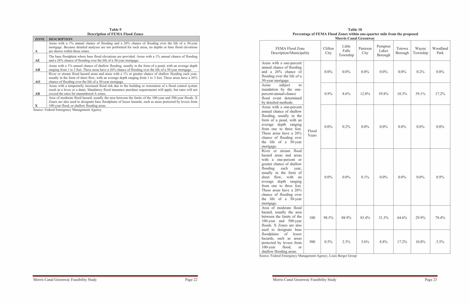
More detailed analyses of the FEMA data and the FEMA zone definitions are provided in Tables 9 and 10. The analysis shows that over 50% of land within one-quarter mile of the Greenway in Pompton Lakes and Wayne are in a high-rated flood zone. This is most likely caused by the close proximity to the Pompton River. The purpose of this flood area analysis was to determine a route that would not impact existing flood conditions, and to determine how the Morris Canal Greenway could potentially benefit a particular municipality’s flood management strategy. For example, the proposed Greenway could serve a dual purpose of localized flood storage and recreation.
Morris Canal Greenway Feasibility Study Page 22
Table 9 Description of FEMA Flood Zones
ZONE DESCRIPTION
A
Areas with a 1% annual chance of flooding and a 26% chance of flooding over the life of a 30-year mortgage. Because detailed analyses are not performed for such areas, no depths or base flood elevations are shown within these zones.
AEThe base floodplain where base flood elevations are provided. Areas with a 1% annual chance of flooding and a 26% chance of flooding over the life of a 30-year mortgage.
AHAreas with a 1% annual chance of shallow flooding, usually in the form of a pond, with an average depth ranging from 1 to 3 feet. These areas have a 26% chance of flooding over the life of a 30-year mortgage.
AO
River or stream flood hazard areas and areas with a 1% or greater chance of shallow flooding each year, usually in the form of sheet flow, with an average depth ranging from 1 to 3 feet. These areas have a 26% chance of flooding over the life of a 30-year mortgage.
AR
Areas with a temporarily increased flood risk due to the building or restoration of a flood control system (such as a levee or a dam). Mandatory flood insurance purchase requirements will apply, but rates will not exceed the rates for unnumbered A zones.
X
Area of moderate flood hazard, usually the area between the limits of the 100-year and 500-year floods. X Zones are also used to designate base floodplains of lesser hazards, such as areas protected by levees from 100-year flood, or shallow flooding areas.
Source: Federal Emergency Management Agency
Morris Canal Greenway Feasibility Study Page 23
Table 10 Percentage of FEMA Flood Zones within one-quarter mile from the proposed
Morris Canal Greenway
FEMA Flood Zone Description/Municipality
Clifton City
LittleFalls
Township
Paterson City
Pompton Lakes
Borough
TotowaBorough
Wayne Township
Woodland Park
Areas with a one-percent annual chance of flooding and a 26% chance of flooding over the life of a 30-year mortgage.
Flood Years
0.0% 0.0% 0.0% 0.0% 0.0% 0.2% 0.0%
Areas subject to inundation by the one-percent-annual-chance flood event determined by detailed methods.
0.9% 8.6% 12.8% 59.8% 18.3% 59.1% 17.2%
Areas with a one-percent annual chance of shallow flooding, usually in the form of a pond, with an average depth ranging from one to three feet. These areas have a 26% chance of flooding over the life of a 30-year mortgage.
0.0% 0.2% 0.0% 0.0% 0.0% 0.0% 0.0%
River or stream flood hazard areas and areas with a one-percent or greater chance of shallow flooding each year, usually in the form of sheet flow, with an average depth ranging from one to three feet. These areas have a 26% chance of flooding over the life of a 30-year mortgage.
0.0% 0.0% 0.1% 0.0% 0.0% 0.0% 0.9%
Area of moderate flood hazard, usually the area between the limits of the 100-year and 500-year floods. X Zones are also used to designate base floodplains of lesser hazards, such as areas protected by levees from 100-year flood, or shallow flooding areas.
100 98.5% 88.9% 83.4% 31.3% 64.6% 29.9% 78.4%
500 0.5% 2.3% 3.6% 8.8% 17.2% 10.8% 3.5%
Source: Federal Emergency Management Agency, Louis Berger Group

Morris Canal Greenway Feasibility Study Page 24
4.2.3 Environmentally Sensitive Protected Lands
In addition to an analysis of Land Use/Land Cover and FEMA data, an inventory of other environmental concerns was also undertaken. To inventory environmentally sensitive areas that are recognized by the State’s Department of Environmental Protection, the Greenway route was cross-referenced with the State’s Natural Heritage Priority Sites. Natural Heritage Priority Sites are defined as follows:
The Natural Heritage Priority Sites Coverage was created to identify critically important areas to conserve New Jersey's biological diversity, with particular emphasis on rare plant species and ecological communities. Natural Heritage Priority Sites are based on analysis of information in the New Jersey Natural Heritage Database. Source: NJDEP
The analysis identified two Priority Sites within one-quarter mile from the Greenway. Those sites are:
Lincoln Park Gravel Pits: Wetland habitat for endangered plants in the Borough of Lincoln Park and Pequannock Township (Morris County), across the river from the Greenway. Pompton River Gravel Bar Site: A series of small gravel bars and gravelly shoreline along the Pompton and Ramapo Rivers, located in Pompton Lakes Borough, Wayne Township, and Pequannock Township.
A significant portion of the Pompton River Gravel Bar Site is owned by Passaic County and Wayne Township. The sites are shown in Figure 6 (page 25).
Although much of the Greenway is in wooded areas, an analysis using the NJDEP’s Landscape data shows that no endangered species or rare animals are within the vicinity of the Greenway.
Morris Canal Greenway Feasibility Study Page 25
Figure 6 Natural Heritage Sites along the Morris Canal Greenway
Source: NJDEP 2007 LU/LC, The Louis Berger Group, 2011
In addition to Natural Heritage Priority Sites, the Pompton Feeder section of the Greenway (from Pompton Lakes to the Mountain View train station) is located within or in close proximity to environmentally sensitive areas as defined by the Permit Extension Act of 2008.
4.3 Historic Districts and Historically Significant Land
Given its inherent linear character, the proposed Morris Canal Greenway represents an opportunity to tie together many of the County’s historic sites. The role of the Greenway is further exemplified because it functions as a historic resource itself, as its alignment refers back to the Morris Canal Historic District. Several of the historic sites along the Greenway either evolved as a function of the Canal or served as the heart of Passaic County’s historic, industrial pattern that developed around the Morris Canal. The Morris Canal Greenway passes along three historical districts that are recognized by the state. These Districts include:
The Dublin Historic District, City of Paterson; The Great Falls of the Passaic Historic District, City of Paterson; andThe Morris Canal Historic District, within Passaic County in the municipalities of Pompton Lakes, Wayne, Little Falls, Woodland Park, Paterson, and Clifton.

Morris Canal Greenway Feasibility Study Page 26
The Dublin Historic District in Paterson, New Jersey was historically bound by the Morris Canal, Garret Mountain and Main Street with a populated area along Market Street. Today the neighborhood makes up “Little Lima” and “Little Italy.” Dublin was downtown Paterson's first distinct neighborhood that evolved around the industrial mills along the east bank of the Passaic River. Several of the old mill buildings have been converted into housing and retail, while others were converted into community spaces such as the Paterson Museum and New Jersey Community Development Corporation (NJCDC).
The Great Falls of the Passaic Historic District was developed by Alexander Hamilton, the first U.S. Secretary of the Treasury, and Pierre Charles L'Enfant, the master planner of Washington, D.C. The Great Falls Historic District is the site of the first attempt in the United States to harness the power of a major river for industrial purposes. The district includes an elaborate, three-tiered system of raceways, numerous 19th- and early 20th-century manufacturing buildings and a hydroelectrical plant, as well as the Great Falls themselves. In 2009, President Barack Obama designated the Great Falls of Paterson as a National Park. The National Parks Service is currently working with a group of community stakeholders, including the City of Paterson and Passaic County, to develop a General Management Plan for the national park.
Individual historic properties were identified by using the NJDEP GIS dataset and supplementing the data with additional historical input from local historians. Figures 7 through 10 (pages 27 through 30) illustrate key historic properties. A full list of properties and their attributes is located in the Appendix Section I.II, found at the end of this report.
Several of the historic sites are of particular relevance, as they had a direct functional relationship with the Morris Canal. These sites include aqueducts used by boats on the Morris Canal to cross the Shingack Brook and Peckman River. While these sites along the Morris Canal Greenway have important historic potential, they also represent an impediment to a contiguous Greenway, as they are both bodies of water that need to be crossed with no safe alternate routes around them.

Morris Canal Greenway Feasibility Study Page 27
Figure 7 Little Falls Historic Resources
Source: NJDEP, The Louis Berger Group, 2011, Google Earth
Morris Canal Greenway Feasibility Study Page 28
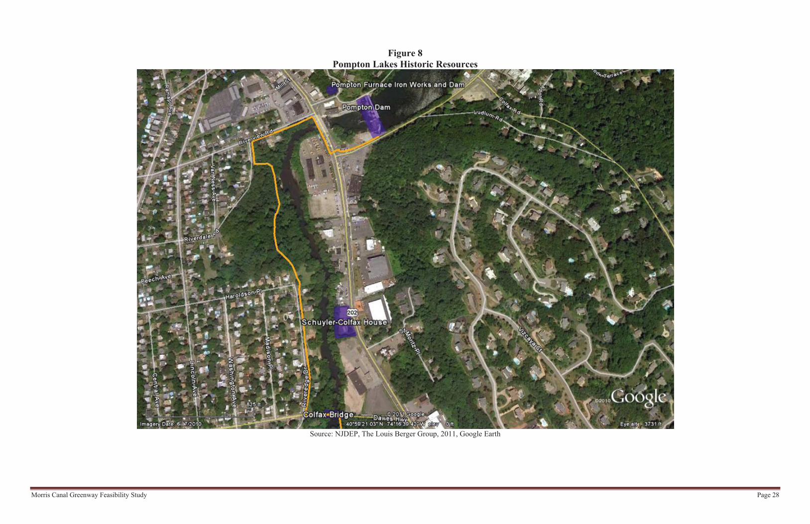
Figure 8 Pompton Lakes Historic Resources
Source: NJDEP, The Louis Berger Group, 2011, Google Earth

Morris Canal Greenway Feasibility Study Page 29
Figure 9 Wayne (Mountain View Train Station) Historic Resources
Source: NJDEP, The Louis Berger Group, 2007, Google Earth

Morris Canal Greenway Feasibility Study Page 30
Figure 10 Paterson Historic Resources
Source: NJDEP, The Louis Berger Group 2011, Google Earth

Morris Canal Greenway Feasibility Study Page 31
4.4 Transportation Connectivity
The Greenway could have substantial potential to act as a transportation corridor because of its linear character, both by itself and by connecting different existing transportation facilities located along its route. GIS analysis cross-referenced a one-quarter mile buffer around the Greenway with public transportation facilities and services. The analysis indicated that there are 352 New Jersey Transit bus stops along 23 different New Jersey Transit bus lines running near various sections of the Greenway9, as shown in Figure 11 (below). As a result, users of the Greenway would have the opportunity to take a one-way bus ride from an originating location (northern or southern) along the Greenway and then walk or ride back to their starting location. This makes one-way use of the Greenway a possibility and could increase the use for those interested in shorter trips or commuting along the Greenway.
Figure 11Bus Routes with Stops Along the Greenway
Source: NJ Transit, Google Earth, Louis Berger Group
In addition to bus service, the Greenway also includes two NJ Transit train stations within one-quarter mile from its alignment. These stations are the Mountain View and Little Falls Stations along the Montclair-Boonton Line. Both stations are less than 0.2 miles from the Greenway, and transit riders could easily be directed onto the Greenway because both have a direct route near the Greenway. In addition, other rail stations along the Montclair-Boonton Line could be used to access the Morris County portion of the
9 Bus lines that have stops along the Greenway are: 11, 28, 139, 190, 191, 192, 193, 194, 195, 197, 198, 324, 365, 397, 702, 704, 705, 707, 712, 748, 871, 970, and 971.
Morris Canal Greenway Feasibility Study Page 32
Morris Canal Trail. Similar to the bus service, the train service can be used to provide one-way transportation to another part of the Morris Canal Trail, with the expectation of utilizing the Morris County and Passaic County portions of the Morris Canal Greenway as a one-way pedestrian or bicycle trip back to the origin point. The train stations also provide parking facilities, including parking for disabled users. As such, the train stations may also provide opportunity for users with disabilities to use the Greenway for shorter trips.
In addition to mass transit, the Greenway also connects with other existing or planned pedestrian trails. These trails include the existing West Essex Rail Trail, Lenape Trail, and Weasel Brook Greenway, as well as the future Morris County Rail Trail and the proposed NJ Silk Road Trail. Connection of the Greenway with these trails provides an extension of the Greenway’s amenities for people coming from other municipalities within and beyond Passaic County.
4.5 Economic Activity
The Greenway traverses in close proximity to multiple local downtowns, where “Mom and Pop” retailers provide a diverse palette of local businesses and services, compatible with the pedestrian-oriented and historic character of the Greenway. Several major centers of economic activity are located along the Greenway, including major malls that usually host large-scale retailers, accompanying restaurants and smaller retail establishments. Their ability to accommodate substantial parking can provide an asset to the Greenway. The Greenway thus provides an opportunity to accommodate access to and enhance the economic opportunity for both local downtowns and major commercial centers.
To ascertain the potential of the Greenway to connect along local retail and economic activity centers, a list of retailers, restaurants, and select personal services was collected from the New Jersey Department of Labor and Workforce Development. The list identified 1,851 businesses in the County that are retailers,10 restaurants and personal services establishments, such as hair salons, dry cleaners, and other similar businesses.
GIS was used to account for the number of identified businesses located within one-quarter mile from the Greenway, as represented in Figure 12 (page 33). The analysis showed that approximately 158 retail, service, and restaurant businesses are located within a ten-minute (one-quarter mile) walking distance from the Greenway. Additional GIS analysis of land categorized as commercial/services in the NJDEP 2007 Land Use/Land Cover data confirms that these areas with high concentrations of commercial establishments have a high percentage of commercial land use.
10 Removing auto, boat, and used car dealers. Also removing wholesalers, auto mechanics, and auto repair shops.��

Morris Canal Greenway Feasibility Study Page 33
Source: NJDEP, NJDOL, Google Earth, The Louis Berger Group, 2007
5 Site Selection Process
The site selection process identified key sites or sections of the Greenway that could substantially affect the overall feasibility of creating a contiguous Greenway. These sites may represent insurmountable challenges that could reduce the overall length of the Greenway. The purpose of selecting these sites is to identify the critical issues that present risks to users of the Greenway.
Through detailed field inspections, GIS mapping, information obtained during public outreach meetings and in consultation with local experts and members of the Project Team, it was determined that a substantial portion of the former Morris Canal could be assembled for use as a Greenway (see Section 3 of this report, page 10). The North Jersey District Water Supply Commission (NJDWSC) controls over 26% of this potential land assemblage. In consideration of the importance of this Greenway segment, the Passaic County Planning Department has initiated discussions with NJDWSC to enable public use of the land above the NJDWSC aqueduct for passive recreational purposes as part of the Morris Canal Greenway. The results of this discussion would be integrated within the overall Greenway Plan. The following analysis discusses lands other than those owned by NJDWSC, and the opportunities and challenges that they represent in achieving Greenway objectives.
Figure 12 Commercial Activities and Land Use within one quarter-mile from the proposed
Morris Canal Greenway
Morris Canal Greenway Feasibility Study Page 34
Because the Greenway has not yet been established as a distinct entity, many of the sites along the Greenway would benefit from relatively minor site-specific improvements, such as the addition of sidewalks or repairs of existing sidewalks, that would benefit their integration within the Greenway. While such improvements are important, the focus of this study is to identify key impediments or opportunities that need to be addressed to enable the creation of a contiguous Greenway. Conversely, sites or sections of the Greenway that warrant new sidewalks for safety reasons or require repairs that go beyond standard maintenance have also been identified as part of this study.
Other considerations, such as the acquisition of private residential property, were not considered in this study, especially in cases where alternate access opportunities can be realized. Similarly, acquisition of brownfields or contaminated property was not considered a feasible option if alternate access alternatives were available. Acquisition of such properties might be considered as part of a parallel, longer-term effort.
5.1. Selection Criteria
Several factors were developed to determine which sites would be eligible for consideration in terms of improvements.
The following criteria were established utilizing similar criteria to that used by the Open Space and Farmland Preservation Trust Fund Advisory Committee in their funding selection process, as stated in the 2001 Passaic County Open Space and Recreation Master Plan. Such criteria were established early as fundamental to the site selection process, and were stipulated in the ANJEC grant application documentation:
Sites (areas) of existing open space along the canal and parcels highly deserving of preservation and/or should be restored to open space due to environmental sensitivity or location.Sites (parcels) that enable connectivity whereby residents will be able to traverse the entire length of the trail on foot or bicycle safely.
After closer physical inspection of the Greenway’s route, a better understanding of the site-specific conditions was achieved and additional, more specific criteria were identified. Discussion among the Team members as well as public input indicated a variety of conditions to review throughout the route. The discussion regarding specific sites often focused on basic measures and key considerations, including addressing more practical concerns such as cost, difficulty in implementation, safety, and environmental impact.
New goals emerged as a result of internal and public discussions that tie into additional or increased funding sources for aspects such as community livability, public health, environmental sustainability, mobility independence, and self-sufficiency. For all these factors, pedestrian and bicycle transportation have become increasingly important tools.

Morris Canal Greenway Feasibility Study Page 35
The following sections provide an overview of how each factor was considered in the site selection process. The combination of all factors represent a transparent decision process, benefitting from considerable public input sessions. In addition to the criteria, an estimated time frame for implementing the proposed site improvements are discussed.
5.1.1. Connectivity Factors
Given the key objective of creating a contiguous Greenway, the ability of a parcel, site, or Greenway section to connect to the other parts of the Greenway is a critical factor. It is assumed that the longer the Greenway extends, the more valuable an asset it becomes for County residents and the general public. This is especially true if a site serves a significant portion of the Greenway, thereby reducing access to both the Greenway and resources located along the Greenway.
The connectivity contribution of a site also depends upon the location of the site and its relation to the rest of the Greenway. Sites in the mid-most sections of the Greenway would have a higher value because any investment in connecting the Greenway would bear the most fruit. In addition, the potential of a site to connect schools, libraries, parks, and other public facilities along the Greenway is a key factor for evaluation.
5.1.2. Estimated Construction Costs for the Site
In this phase of the Greenway’s creation, it is not practical to estimate precise construction costs for each of the sites. However, to gauge the potential costs of infrastructure needed for the various sites, this study estimates the costs in a relative manner to the other sites being proposed. Therefore, dollar values will not be used in the assessment but rather a high, low and medium cost factor will be assigned to each site.
The estimated costs do not include maintenance, but rather focus on the initial capital expenditure that would be used for a bridge, new signage, road paint for cross walks, or other infrastructure improvements that would contribute to the overall project cost.
5.1.3. Environmental Sensitivity
As with any construction project, the impact the project has on the environment is always a concern. This is particularly true if the project is meant to enhance the public’s ability to enjoy the outdoors in natural surroundings. Any intrusion on the natural landscape would negatively impact the Greenway’s aesthetics and diminish its experience for the user that wishes to see natural landscapes along the Greenway.
In contrast, any possibility of preservation of the environment would be considered a positive attribute of the site. Negative environmental impacts of a site are ranked as high, medium, and low. A high rating means that a site’s improvements or land acquisition will have a detrimental impact on the environment, whereas a low rating means that there would be a positive impact on the environment.
Morris Canal Greenway Feasibility Study Page 36
5.1.4. Safety Considerations
Safety considerations were paramount when evaluating each site. Safety considerations along the Greenway relate to roadway crossings, signage, the availability and conditions of sidewalks, and other factors. In addition, conditions for disabled users are of special concern. As an example, safety improvements to important sites (for connectivity or other reasons) that have poor sidewalk conditions and cross roadways with relatively high traffic volumes and speeds may be more urgent than a similar site with less traffic.
5.1.5. Administrative Challenges
In many instances, the ability to clear administrative obstacles is often thought of after the proposal of a project. Once proposed, the project could be stalled by bureaucratic, legal, or fiscal uncertainty. Even though there is no clear timeline that can be estimated for these types of challenges, the involvement of multiple jurisdictions can often delay the implementation process. Therefore, it was generally assumed that the more jurisdictions associated with a site (including permits and approvals), the greater its implementation challenge.
5.1.6. Historic Preservation
A top priority of this project is the preservation of the Morris Canal and its legacy in the County. This includes not only the Canal’s Tow Path and Prism, but also the various other infrastructure elements that were important to the daily functioning of the Canal such as locks, aqueducts and guard houses.
Although the Morris Canal is the major focus of this study’s historic preservation efforts, it is also important to preserve the County’s industrial history and unique, local historic sites that thrived along the canal during its use. Any action that assists in directly preserving the Canal’s historic attributes will have a high preservation value.
5.1.7. Alternative Options
In some cases, the recommended improvements for a site may not represent the only option to create a safe and usable Greenway. Other safe alternatives may be available but may not be as desirable, or may locate the Greenway too far from the original Morris Canal route. For this reason, an account of possible alternatives is introduced into the criteria. Presence of alternatives may reduce the urgency of the site from consideration and can lower its overall rating.

Morris Canal Greenway Feasibility Study Page 37
5.2. Summary of Site Findings
The sites identified in the following section have displayed some need for infrastructure improvements to create a safe and contiguous Greenway along the original Morris Canal route. The sites are arranged from north (Pompton Lakes) to south (Clifton).
The basic rating system concept is modeled after the familiar traffic light. The color reflects the level of negative or positive attributes that were assessed for that particular rating factor, green indicating positive attributes and red indicating negative. Each of the factors and their graded attributes are detailed in the individual site assessments on the following pages.
5.3. Selected Specific Site Information
This information is presented on the following pages.

KEY MAP
DETAILED MAP
Pompton Feeder Lock, Wayne. Image courtesy of the Canal Society of New Jersey
Current Site Pictures
SITE CHALLENGES
After a physical inspection of the Proposed Greenway from the Dawes Highway Bridge to Cole Street, the Project Team found that the Greenway, as initially proposed, is unfeasible. Various factors, including erosion of the riverbank, proximity of the original pathway to residences, and frequent flood events deemed the land held by the County as unusable for the Greenway. Although the County owns sections along the Greenway, they are not contiguous due to mul-tiple water bodies, infrastructure and other obstructions, making a path along the historic Morris Canal Route nearly impossible.
Several alternatives were discussed to bypass these obstructions in the Greenway. All of the alternatives required traversing Hamburg Turnpike and Route 202. Both roadways lack sidewalks and experience high traffic speeds and volumes. The alternatives would also traverse a residen-tial neighborhood with narrow roadways and no sidewalks.
Recommended Measures - The preferred alternative was discussed favorably in the public meet-ings and reviewed for its feasibility. This alternative uses the opposite (West) side of the Pompton River to follow the Morris Canal Pompton Feeder. This route better utilizes several existing parks and preserved open space, including the Ventimiglia Tract and Blue Acres property. In addition, the site would connect the southern end of Pompton Lakes with the rest of the Greenway.
Although the Preferred Alternative represents the only available option to provide a safe path-way, its implementation will require several additional steps, including intergovernmental coor-dination and funding. First, the alternative would require the construction of two or more pedes-trian structures to cross the Pompton and Ramapo Rivers, which will require regulatory approv-als and funding. Second, the Greenway would cross onto Morris County land, requiring coordi-nation with Pequannock Township. Third, the Preferred Alternative would traverse the Pompton River Gravel Bar Site, which is a State Natural Heritage Priority Site. This site contains a state criti-cally imperiled plant species which would require more detailed study and sensitivity analyses prior to designing pedestrian access. The above aspects will need to be factored in when consid-ering schedule and budgets for design, implementation, operation and maintenance.
In terms of historic preservation opportunities, the Preferred Alternative does not lend itself to utilization of the historic Dawes Highway Bridge, a reconstruction of the original Colfax Bridge, as it is no longer directly along the route. However, reference to this historic structure could be
provided along the route through interpretive signage.
Notwithstanding the implemen-tation constraints described above, the Preferred Alternative was considered the only safe alternative, and forms an essen-tial element in the long term strategy for maximizing the length and continuity of the Greenway in Passaic County.
Just south of Cole Street, where the Ramapo River meets the Pompton, forms the head of the Pompton Feeder canal. Here, a guard lock was installed to enable boats to enter and leave the river in route to the Pompton ironworks. Two dams and 3,500 feet of guard bank were constructed as part of the Feeder canal, including the Pequannock Spillway dam, better known today as the Pompton Dam.
The preservation of the Pompton Dam is paramount to the histori-cal context of the Morris Canal in Passaic County. The current spill-way was reconstructed in 1928 within 50-feet immediately down-stream from the original spillway. The first spillway, built of stone fill covered in large stones, was replaced by the current spillway with concrete walls capping the earthen Guard Bank at its ends. According to an Army Corps of Engineers Cultural Resources Inventory, the present Pompton Feeder dam is “22.2 feet high and its spillway is a concrete overflow weir which runs the entire 270 foot length of the dam. The concrete wingwall at the right side of the spillway is 124 feet long and 3 feet wide, running perpendicu-lar to the spillway. The left side has a 99-foot-long, 3-foot-wide wingwall.” The spillway was an integral part of the feeder Canal, which enabled water from Greenwood Lake to supply water to the Passaic Falls and the Morris Canal’s eastern division from Mountain View to Newark (Rutsch and Sandy, 1995).
SITE DESCRIPTION
Site No. 1 encompasses the section of the Greenway extend-
ing from the Dawes Highway Bridge in Pompton Lakes Bor-
ough south to Cole Street in Wayne Township. The Greenway
runs along the Ramapo River, referred to historically as the
“Ramapo River Slackwater Canal,” which provided water to
the Pompton Feeder. Much of the property along the east side
of the Ramapo River was purchased or acquired as an ease-
ment by the Passaic County Parks Commission following the
abandonment of the Canal. This land reverted to Passaic
County ownership when the Parks Commission was dissolved.
SITE EVALUATION CRITERIA
Connectivity Opportunities Estimated Construction Cost Environmental Impact Safety Improvement Opportunities Jurisdictional Issues Historical Preservation Opportunities Alternative Options Proposed Timeline Long Term
DAWES BRIDGE SOUTH TO COLE STREET,TOWNSHIP OF WAYNE AND BOROUGH OF POMPTON LAKES
Connectivity Opportunities
Estimated Construction Cost
Environmental Impact
Safety Improvement Opportunities
Jurisdictional Difficulties
Historic Preservation Opportunities
Alternative Options
Proposed Timeline
Provides key connection between Greenway in Pompton Lakes Borough and Wayne Township
Requires construction of two or more pedestrian bridges along the Pompton and Ramapo Rivers; sensitive habitat studies
Traverses a Natural Heritage Priority Site; would require further environmental sensitivity analysis;
Dedicated pedestrian path avoids busy roads
Crossing onto Morris County land
Does not use Dawes Highway Bridge
Preferred alternative represents only
Long term (subject to funding and approvals) feasible option

KEY MAP
DETAILED MAP
Newark Aqueduct crossing over Pompton Feeder, Wayne Image courtesy of the Canal Society of New Jersey
Current Site Pictures
SITE DESCRIPTION
This site is located where the Greenway crosses under
Route 23 parallel to Farmingdale Road in Wayne.
SITE CHALLENGES
The section of the Greenway that passes under Route 23 displays a poor visual image of the Greenway and is not conducive to walking. The surface of the Greenway path under the Route 23 Bridge is uneven and the path beneath the bridge is poorly lit, even in daylight.
Recommended Measures - The above conditions can be addressed by relatively simple infra-structure improvements. To create an even surface below the bridge the County may create a more even earthen path, taking into consideration erosion and sedimentation requirements. Light fixtures could be installed to improve visibility below the bridge. Solar lighting with motion sensors may be considered to reduce costs associated with electrical conduits. The removal of Graffiti should also be a priority.
Vertical clearance of the path beneath the bridge should be compliant with New Jersey Depart-ment of Transportation (NJDOT) standards:
“Access by emergency, patrol, and maintenance vehicles should be considered in establishing the design clearances of structures on bicycle paths. Similarly, vertical clearance may be dictated by occasional motor vehicles using the path. Where practical, a vertical clearance of 10' (3 m) is desirable for adequate vertical shy distance.”
Since Route 23 is a state highway, the NJDOT will need to be contacted if any work is to occur under the bridge.
SITE EVALUATION CRITERIA
Connectivity Opportunities Estimated Construction Cost Environmental Impact Safety Improvement Opportunities Jurisdictional Issues Historical Preservation Opportunities Alternative Options Proposed Timeline Short Term
ROUTE 23 OVERPASS, TOWNSHIP OF WAYNE
Connectivity Opportunities
Estimated Construction Cost
Environmental Impact
Safety Improvement Opportunities
Jurisdictional Difficulties
Historic Preservation Opportunities
Alternative Options
Proposed Timeline
Path below bridge provides connection between two substantial sections of the proposed Greenway
Lighting and surface treatment at moderate cost
No disturbance of ecologically sensitive areas
Proposed improvements will increase
NJDOT approval/coordination for vertical clearance
Only affects Morris Canal Historic District
Only option available to connect two large sections of the proposed Greenway
Short term
KEY MAP
DETAILED MAP
Cable Lift Bascule Bridge with Curved-Track Rolling Counterweight at Mountain View, Wayne
Current Site Pictures
SITE DESCRIPTION
This section of the Canal Route initially curves closer to
the river and then turns inland further south. It is one of
the few areas in the northern section of the Greenway
where the original Morris Canal route deviates from the
NJDWSC aqueduct right-of-way. The area presents a
more scenic hike for Greenway users, with views of the
Pompton River. The area surrounding the original Canal
route and the existing NJDWSC pipeline right-of-way
consist of an industrial park occupied by several indus-
trial and office buildings.
SITE CHALLENGES
A key objective of the Morris Canal Greenway is to follow the original Morris Canal route as much as possible. Although the section of the Morris Canal in the Haul Road Industrial Area is walkable, acquiring an easement or purchasing land may present unforeseen challenges.
Recommended Measures– The site has both short-term and long-term alternatives. The short-term alternative is for the Greenway to follow the NJDWSC pipeline, extending off the current Greenway. Once authoriza-tion to utilize the NJDWSC land is granted to the County, the ability to create a contiguous path-way exists. However, by deviating from the historic alignment of the Morris Canal, some of the historical ties to the Greenway would be compromised.
The long-term plan is to purchase easements in the industrial park area to preserve the original Morris Canal route. In addition, the easements will also preserve portions of riverside trails that can be beneficial for recreational pedestrian use by employees or residents of the neighborhood.
SITE EVALUATION CRITERIA
Connectivity Opportunities Estimated Construction Cost Environmental Impact Safety Improvement Opportunities Jurisdictional Issues Historical Preservation Opportunities Alternative Options Proposed Timeline Short-TermProposed Timeline Long-Term
HAUL ROAD INDUSTRIAL PARK, TOWNSHIP OF WAYNE
Connectivity Opportunities
Estimated Construction Cost
Environmental Impact
Safety Improvement Opportunities
Jurisdictional Difficulties
Historic Preservation Opportunities
Alternative Options
Proposed Timeline Short-Term
Connects an Industrial Park to the Greenway; links the Greenway with the future Morris County Rail Trail.
Long-term: Cost of an easement may be high; one parcel may need to be purchased because an easement divides the property in half.
Short-term: No sensitive ecological areas disturbed, as NJDWSC ROW is already established. Long-term: Environmental preservation will be accomplished through easements along the river.
No traffic concerns. Path surface is relatively even.
Will require easement from NJDWSC.
Short-term: Deviates from the original Morris Canal Route.Long-term: Preservation of the original Morris Canal route.
The only other alternative through the industrial park requires easements and is costly.
Pending NJSWDC Easement .
Proposed Timeline Long-Term Purchase easements in the Industrial Park to preserve the original Morris Canal Route.

KEY MAP
DETAILED MAP
Counterweight Lift Bridge at Mountain View, Wayne
Current Site Picture
SITE DESCRIPTION
This section of the Greenway focuses on the area at
which the Pompton Feeder and the Morris Canal inter-
sect. Because of this, the Greenway splits into two direc-
tions: one section of the Greenway travels west to con-
nect with the Greenway in Morris County, while the other
section of the Morris Canal alignment continues east in
Passaic County through the remainder of Wayne, Little
Falls, Woodland Park, Paterson, and Clifton.
The western portion of the Canal originally extended
into Morris County across the Pompton Aqueduct. Rem-
nants of the Pompton Aqueduct still remain on the
Passaic County side of the Pompton River.
SITE CHALLENGES
The section of the Canal that runs west from the intersection of the Pompton Feeder and Morris Canal spans nearly 0.15 miles or roughly 750 feet. Although this section is a relatively short appendage to the Greenway route, it would provide a valuable link to the Morris County portion of the Greenway and an excellent view of both the Pompton River and remnants of the Pompton Aqueduct.
This segment crosses three parcels of land in Wayne Township. Two of the parcels are classified as commercial, and are used as a car wash and a restaurant. The third site is owned by the New Jersey Department of Environmental Protection and is used as a boat launch into the Pompton River. Passaic County would need to acquire an easement across the commercial land to com-plete the western extension of the Greenway. This would provide public boat access to the Pompton River, and enhance multimodal transportation routes between the two counties. A preferred long-term extension of the Greenway would be to acquire an easement that would enable this route.
Recommended Measures
Currently, a short-term alternative exists for pedestrians and bicyclists traveling from Morris County who wish to access the Greenway. The alternative route heads east on-road along Moun-tain View Boulevard, then makes a left turn through an easement in the above-mentioned shop-ping area at Sherman Street.
The long-term plans for this section would require easements in the two commercial properties and permission to use the NJDEP property for river access.
The ability to physically link this section to the Greenway is hampered by the inability to cross the NJ Transit railroad tracks. It is unlikely that NJ Transit will provide another pedestrian crossing a few yards from the Mountain View Boulevard crossing. Because the site cannot physically link to the Greenway, it would serve as a “reflection point” for pedestrians wishing to see the historic Aqueduct and access the river.
SITE EVALUATION CRITERIA
Connectivity Opportunities Estimated Construction Cost Environmental Impact Safety Improvement Opportunities Jurisdictional Issues Historical Preservation Opportunities Alternative Options Proposed Timeline Short-TermProposed Timeline Long-Term
MOUNTAIN VIEW RAIL AREA (POMPTON FEEDER CONNECTION), TOWNSHIP OF WAYNE
Connectivity Opportunities
Estimated Construction Cost
Environmental Impact
Safety Improvement Opportunities
Jurisdictional Difficulties
Historic Preservation Opportunities
Alternative Options
Proposed Timeline Short-Term
The section is an appendage to the Greenway and does not physically link any sections of the Greenway together.
Long-term: The cost of the easementsShort-term: Pedestrian safety improvements along Mountain View Boulevard
No impact anticipated
Long-term: Crossing the rail tracks in the area to get to the site is hazardous.
Long-term: The land that the Canal traverses is privately owned. The NJDEP owns the boat launch site. The site would preserve the original Morris Canal Route, and provide access to the Aqueduct abutment
The short-term alternative is to utilize Mountain View Boulevard to cross the railroad tracks.
Mountain View Boulevard directional signage to Greenway
Proposed Timeline Long-Term Easements from Commercial land owners.

KEY MAP
DETAILED MAP
Broad Street Railroad Bridge along Morris Canal, Paterson
Current Site Picture
SITE DESCRIPTION
This site is on the border of Wayne Township and Totowa
Borough, and crosses the Singac Brook along the
NJDWSC pipeline. It is also a historic site recognized by
the State of New Jersey as the Preakness Aqueduct in the
Morris Canal Historic District.
SITE CHALLENGES
The site is currently difficult to walk because pedestrians must cross Singac Brook, historically known as Shingack Brook, which is a small brook yet during periods of heavy precipitation can create flood conditions.
Recommended Measures–
No viable alternative pedestrian route exists that would circumvent Singac Brook. To mitigate this obstacle, construction of a small foot bridge over Singac Brook, as pictured in Figure 1 is recommended. It is also recommended that the bridges meet the NJDOT standards for both pedestrian and bicycle use.
SITE EVALUATION CRITERIA
Connectivity Opportunities Estimated Construction Cost Environmental Impact Safety Improvement Opportunities Jurisdictional Issues Historical Preservation Opportunities Alternative Options Proposed Timeline
SINGAC BROOK BRIDGE, TOWNSHIP OF WAYNE
Connectivity Opportunities
Estimated Construction Cost
Environmental Impact
Safety Improvement Opportunities
Jurisdictional Difficulties
Historic Preservation Opportunities
Alternative Options
Proposed Timeline Short-Term
This site links the Greenway behind the Totowa Industrial Park.
The cost of a small footbridge.
No environmental impact expected.
Building the footbridge reduces chances of accidents from crossing the Singac Brook.
Singac Brook is a historical recognized site (Shingak Brook).
The ability to walk to the Preakness Aqueduct increases the public’s awareness of its historical significance and its connection to the Morris Canal.
No alternatives around the Brook are present.
Immediate.

KEY MAP
DETAILED MAP
Broad Street at Belgrade Avenue, Paterson
Current Site Pictures
SITE DESCRIPTION
This section of the Greenway crosses Interstate 80 and
Route 46, both highly traveled roadways in Passaic
County. To cross these major roadways, the Greenway
would either need a pedestrian bridge over these high-
ways or an existing road-based alternative. A long-term
preference for this crossing is to construct bridges over
the two highways that would create a truly contiguous
trail. However, a short-term alternative is to improve
bicycle and pedestrian facilities along existing roads.
These include West End Road and Riverview Drive.
SITE CHALLENGES
Unlike other sites that only require safety improvements to enable crossing roads, this site has no alternate routes to cross the major highways. However, its central position within the overall Greenway alignment makes this a critical connection site. The section in which the site is located is also the major turning point on the Greenway in terms of off-road versus on-road trail. The Greenway north of this section is almost entirely trail-based with little on-road usage, whereas the Greenway south of this section is mostly roadway-based (i.e., sharing the roadway).
The use of existing roadways can provide opportunities to maintain Greenway continuity where major infrastructure, property or other obstacles are present, or where the trail is non-existent. However, their use for such a purpose can also present challenges if they are not suitable for pedestrians or bicycles. Consequently, while the roadway alternative proposed for crossing Inter-state 80 and Route 46 can provide a vital pedestrian link across the major highways, pedestrian safety conditions associated with the existing roadway should be reviewed and improved to better accommodate Greenway users.
Recommended Measures–
As illustrated in the Detailed Conditions Map, the walking conditions on Riverview Drive beneath the Interstate 80 bridge, in front of the Home Depot Shopping Center, then across the Route 46 bridge are potentially hazardous to pedestrians. The implementation of safety improvements along Riverview Drive includes the installation of a crosswalk, a guard railing for pedestrian safety, and repair of sidewalks.
SITE EVALUATION CRITERIA
Connectivity Opportunities Estimated Construction Cost Environmental Impact Safety Improvement Opportunities Jurisdictional Issues Historical Preservation Opportunities Alternative Options Proposed Timeline Short-TermProposed Timeline Long-Term
DIVERSION OVER INTERSTATE 80 AND ROUTE 46, TOWNSHIP OF WAYNE AND BOROUGH OF TOTOWA
Connectivity Opportunities
Estimated Construction Cost
Environmental Impact
Safety Improvement Opportunities
Jurisdictional Difficulties
Historic Preservation Opportunities
Alternative Options
Proposed Timeline Short-Term Alternative
The site is a vital link between the northern and southern parts of the Greenway.
Striping, signage, and sidewalk repair and construction.
No environmental impact is expected.
Enhancing this site increases pedestrian safety.
County owns Riverview Drive and therefore maintains from curb to curb yet sidewalks are within municipal jurisdiction and maintained by property owners in accordance with local regulations.
No historical preservation is anticipated.
Immediate pedestrian safety improvements to county roadways.
Bridges over Routes 80 and 46.

KEY MAP
DETAILED MAP
Union Avenue Bridge over Morris Canal, Little Falls
Current Site Pictures
SITE DESCRIPTION
This site is within the Totowa municipal boundary and
borders the Township of Wayne. It is adjacent to the
Passaic Valley Water Commission plant, a state recog-
nized historic site, and the Beattie House, a locally recog-
nized historic site. The site could be connected via a
narrow walkway from the NJDWSC right-of-way to Union
Boulevard at a point just in front of the Union Avenue
Bridge.
SITE CHALLENGES
The current condition of the site is not conducive to safe pedestrian or bicycle use. The current foot path that exists within the NJDWSC pipeline right-of-way to Union Boulevard is a worn foot path, approximately one foot in width. The pathway leads behind the guard rails for the bridge and emerges onto Union Boulevard. Although the pathway can be traversed, its earthen surface makes it prone to erosion during precipitation events, further exacerbating the already uneven pathway surface.
Recommended Measures–
The current pathway needs regrading to create a more gradual slope, and surface treatment with railings to accommodate handicapped Greenway users. The site currently has a sign noting that the Morris Canal crossed the area. The current condition of the site obstructs the view of the pathway behind the guard railing, making it difficult to locate. Additional signage is recom-mended to direct pedestrians and bicyclists onto the lower trail from Union Boulevard. Addition-ally, an easement is recommended to accommodate the small portion of land used to reach Union Boulevard from the NJDWSC pipeline trail. This easement would most likely be less than several square feet to accommodate the upgraded pathway.
SITE EVALUATION CRITERIA
Connectivity Opportunities Estimated Construction Cost Environmental Impact Safety Improvement Opportunities Jurisdictional Issues Historical Preservation Opportunities Alternative Options Proposed Timeline
GREENWAY TO UNION BLVD. CONNECTION (WALKWAY TO BRIDGE), BOROUGH OF TOTOWA
Connectivity Opportunities
Estimated Construction Cost
Environmental Impact
Safety Improvement Opportunities
Jurisdictional Difficulties
Historic Preservation Opportunities
Alternative Options
Proposed Timeline Short-Term
Connects the NJDWSC pipeline to Union Avenue.
A small ramp with hand railing and the cost of easements.
No impact is anticipated.
A well-constructed access way will reduce accidents.
The site crosses both the Wayne and Totowa borders.
No historical preservation is anticipated.
There are no alternatives.
Immediate.

KEY MAP
DETAILED MAP
Morris Canal along Main Street, Little Falls
Current Site Pictures
SITE EVALUATION CRITERIA
Connectivity Opportunities Estimated Construction Cost Environmental Impact Safety Improvement Opportunities Jurisdictional Issues Historical Preservation Opportunities Alternative Options Proposed Timeline
SITE DESCRIPTION
The portion of Greenway examined at this site is within
the Morris Canal Park, which is owned and maintained by
the Township of Little Falls. The park is north of Main
Street and directly across the Passaic River from the
Passaic Valley Sewerage Commission plant.
More specifically, the park is behind the Little Falls Cen-
tral Business District that has numerous local shops and
services. The Park includes the main municipal parking
lot that serves the storefronts along Main Street. The
original Morris Canal route passed through the park and
its parking lot, continuing onto Wilmore Road.
SITE CHALLENGES
The Morris Canal Park in Little Falls is an excellent location for Greenway users to overlook the Falls and to view the historical water plant.
Recommended Measures –
County staff are working with Little Falls staff and local volunteers on the Redevelopment Com-mittee to ensure that the Morris Canal Greenway enhances the parking lot area. The County hopes that a walkway through the parking lot area could be established to provide a scenic, safe, and handicapped accessible passage through the area, while not restricting the Township’s ability to properly create a functional parking area.
In addition to a walking path through the parking lot, handicapped access improvements to the park should also be considered. Currently, the only way to enter the park from Main Street is via a set of stairs that lead to a ramp. This restricts access to the park by handicapped individuals or people who cannot, or have difficulty, climbing stairs. Discussions with Township representa-tives provided information that a parcel of land, near the corner of Main Street and Paterson Avenue, might be donated to the Township. This additional parcel could be utilized by the Town-ship for a handicapped entrance into the park.
Aside from the improvements to the park, additional infrastructure such as crosswalks and traffic-calming devices (including blinking lights and reduction in travel speeds) may be installed. Signage is also recommended at the entrance and exit of the parking lot. Currently there is no cross walk beyond the merged roadways of Paterson Avenue and Maple Street, where the parking lot entrance/exit is located.
LITTLE FALLS MORRIS CANAL PARK (ACCESS AND PARKING LOT AREA),TOWNSHIP OF LITTLE FALLS
Connectivity Opportunities
Estimated Construction Cost
Environmental Impact
Safety Improvement Opportunities
Jurisdictional Difficulties
Historic Preservation Opportunities
Alternative Options
Proposed Timeline
The site links the Morris Canal Park into the Greenway.
Building of a handicapped access ramp and reconfiguration of the parking lot.
No impact anticipated .
Will allow handicapped access and prevent accidents in and around the parking lot area .
The Morris Canal Park is owned by the Township of Little Falls while a large portion of the municipal parking lot is owned by North Jersey District Water Supply Commission
Changes to the site will preserve the Greenway on the original Morris Canal route.A person using the Greenway can choose to travel down Main Street and link up with the Greenway at Memorial Park.
Short-term.

KEY MAP
DETAILED MAP
Paterson Avenue Trolly Bridge over Morris Canal, Little Falls
Current Site Pictures
SITE EVALUATION CRITERIA
Connectivity Opportunities Estimated Construction Cost Environmental Impact Safety Improvement Opportunities Jurisdictional Issues Historical Preservation Opportunities Alternative Options Proposed Timeline
SITE DESCRIPTION
This site runs south from Paterson Avenue to Main Street,
between Maple Street and Van Ness Avenue. More spe-
cifically, the Proposed Greenway follows the original
Morris Canal behind the former STS Tire property and
Schumacher Chevrolet. The original Morris Canal route
extended from the Morris Canal Park across Paterson
Avenue south between Maple and Van Ness. The north-
ern portion of this site is owned by the North Jersey
District Water Supply Commission.
SITE CHALLENGES
Emerging from the Morris Canal Park parking lot area and crossing Paterson Avenue, the Green-way then traverses onto NJDWSC property. The NJDWSC property is clearly labeled by two large green poles. The Greenway follows the NJDWSC property to the east and the picnic area of American Legion Post 121 to the north.
Recommended Measures –
The acquisition of an easement along the properties owned by STS Tire and Schumacher Chevro-let to create a small walkable pathway could be completed to preserve the Morris Canal’s original route. The Greenway built on the easement should acknowledge any privacy issues that adjacent property owners or residents may have.
Additional comments concerning the site were expressed at the Little Falls public meeting. Some suggested that the traffic on Main Street was too fast for pedestrians to safely cross the street, thereby inhibiting connectivity to the Greenway’s route. Due to these comments, it is advised that traffic-calming devices and a crosswalk be installed across Main Street for pedestrians to safely reach Memorial Park at the corner of 1st Avenue and Main Street.
PATERSON AVENUE SOUTH TO MAIN STREET, TOWNSHIP OF LITTLE FALLS
Connectivity Opportunities
Estimated Construction Cost
Environmental Impact
Safety Improvement Opportunities
Jurisdictional Difficulties
Historic Preservation Opportunities
Alternative Options
Proposed Timeline
The site links the Morris Canal Park to Memorial Park and the Municipal Morris Canal Bikeway.
The cost of easements.
No impact anticipated .
A crosswalk and traffic calming is needed on Main Street.The Morris Canal Park is owned by the Township of Little Falls while a large portion of the municipal parking lot is owned by North Jersey District Water Supply Commission
A portion of the land in question is privately owned.
The route would preserve the original Morris Canal route.
An on-road route on either Maple Street or Van Ness Avenue can be used as alternatives.
Short-term.

KEY MAP
DETAILED MAP
Peckman River Aqueduct, Little Falls
Current Site Pictures
SITE EVALUATION CRITERIA
Connectivity Opportunities Estimated Construction Cost Environmental Impact Safety Improvement Opportunities Jurisdictional Issues Historical Preservation Opportunities Alternative Options Proposed Timeline
SITE DESCRIPTION
This site is located in the southern section of the Peck-
man Preserve between Wilmore Road and Cedar Grove
Road. The site is recognized by the state as a historic
place known as the “Morris Canal prism over Peckamin”.
The Morris Canal’s original route passes through the
Peckman Preserve and crosses the Peckman River along
the southwestern side of the preserve.
This site is an important connection because it links the
two sections of the newly constructed Morris Canal Bike-
way in Little Falls and provides multimodal access to the
County-owned Peckman Preserve.
SITE CHALLENGES
The current proposed Greenway has pedestrian and bicycle users traveling between Wilmore Road and the Peckman Preserve, then crossing the Peckman River at the southern end of the Preserve to reach the newly-created Little Falls Morris Canal Bikeway. Although an alternative route that utilizes Wilmore Road, East Lindsley Road and Cedar Grove Road was reviewed, the public feedback from residents was that this alternative was unsafe due to high travel speeds by automobiles in the area. The residents also liked the idea of installing a foot bridge across the Peckman River to limit their walking on the roadways.
Recommended Measures–
The Peckman Preserve Study, completed in June 2010, outlines the concept of adding a foot bridge to traverse the Peckman River. The study, completed by landscape architects, provides several example of foot bridges and configurations of the landscape to accommodate the bridge. Representatives of Township of Little Falls stated that the Township wanted to place a bridge there, but did not do so because of permitting and logistical obstacles.
Additional jurisdictional issues may arise because the site is in an environmental sanctuary and the bridge would be crossing a historical site recognized by the state. However, a well-designed bridge will enhance the parklands and provide more incentive for pedestrians to learn about the historical significance of the area.
The County has identified part of an historic bridge in Paterson, the Fair Lawn Avenue Bridge, as a potential bridge of comparable size for the Peckman River. More historic, structural, and envi-ronmental analysis will be needed to determine if part of the Fair Lawn Avenue Bridge would be suitable.
PECKMAN PRESERVE BRIDGE, TOWNSHIP OF LITTLE FALLS
Connectivity Opportunities
Estimated Construction Cost
Environmental Impact
Safety Improvement Opportunities
Jurisdictional Difficulties
Historic Preservation Opportunities
Alternative Options
Proposed Timeline
This site links the Peckman Preserve to the new Morris Canal Bikeway.
Small foot bridge.
No impact anticipated.
Allows pedestrians to safely cross the Packman River by avoiding unsafe raodways.
The site is a historical site recognized by the state.
The ability to walk to the Peckamin Aqueduct increases the public’s awareness of its historical significance and its connection to the Morris Canal.
No safe alternative is available.
Short-term.

KEY MAP
DETAILED MAP
Morris Canal along Broad Street, Clifton
Current Site Pictures
SITE EVALUATION CRITERIA
Connectivity Opportunities Estimated Construction Cost Environmental Impact Safety Improvement Opportunities Jurisdictional Issues Historical Preservation Opportunities Alternative Options Proposed Timeline Short-TermProposed Timeline Long-Term
SITE DESCRIPTION
This section of the Greenway runs between Broad Street
and the Garden State Parkway in Clifton. Broad Street is
historically significant to the Morris Canal as it was con-
structed in its current location to provide services along
the Canal. Historic homes along Broad Street have been
identified and a portion of the Morris Canal, in the Morris
Canal Park and Nature Preserve in Clifton, has been
meticulously reconstructed.
SITE CHALLENGES
The original Morris Canal route is at the current location of the Garden State Parkway (GSP), prohibiting any type of use other than automobiles. The GSP right-of-way was evaluated for use as an alternative route for pedestrians. Field inspection of the site, however, indicated that perti-nent sections of the GSP right-of-way were too steep to traverse without some improvements. Adjacent residential property further complicates the creation of a safe walkway along the Park-way.
Recommended Measures –
In light of the above, an alternative route for the Greenway in this section is proposed along Broad Street (County Road 509). The Broad Street route has sufficient sidewalks and crosswalks to keep pedestrians safe. However, the addition of a dedicated bicycle lane to Broad Street is recommended to avoid use of sidewalks by bicyclists and to significantly improve bicycle safety conditions.
In order to follow the original Canal route (one of the goals of the project, where attainable), the Greenway must cross the GSP, and therefore a pedestrian bridge would be needed to cross the Parkway. Installation of such a bridge across the Parkway is a long-term goal, as it could be costly and would require multiple approvals. Considering this, the short-term alternative for crossing the Parkway was identified at Allwood Road (County Road 602).
To more effectively connect to the Morris Canal Park and Nature Preserve in Clifton, a crosswalk is recommended at the entrance to the Morris Canal Park. Currently, the only way to cross Broad Street and reach the Park is to use the crosswalk beyond the Route 3 on-ramp. This adds an addi-tional 0.28 miles to a pedestrian’s walk. An alternative way for pedestrians to enter the Morris Canal Park is to create a pedestrian shoulder along the northbound side of Broad Street and create an additional entrance for pedestrians via the northern section of the park.
GARDEN STATE PARKWAY RIGHT OF WAY AND BRIDGE, CITY OF CLIFTON
Connectivity Opportunities
Estimated Construction Cost
Environmental Impact
Safety Improvement Opportunities
Jurisdictional Difficulties
Historic Preservation Opportunities
Alternative Options
Proposed Timeline Short-Term
No changes to connectivity.
A pedestrian bridge across the Parkway can be expensive and will require a study .
No impacts are anticipated.
Pedestrians and bicyclists would be safer if they had their own walkway to the Clifton Morris Canal Park.
The NJ Turnpike Authority would need to give permission for the use of the right-of-way and bridge.
Using the Garden State Parkway and a new bridge would preserve the original Morris Canal route.
The Broad Street alternative allows for safe pedestrian traffic.
Provide safety enhancements to accommodate bicycles on Broad Street. Create Crosswalk to Morris Canal Park.
Proposed Timeline Long-Term Contact the Turnpike Authoirty to Acquire an easement along the Parkway and assess the feasibility of a Bridge that spans the Parkway.

Morris Canal Greenway Feasibility Study Page 49
6. General Greenway Improvements
In addition to site-specific measures, several general improvements were evaluated for their potential to improve Greenway conditions along the entire trail. These improvements are not associated with a specific site, but may justify additional resources as they would increase the value of individual investments at specific sites.
Most importantly, all capital projects along the Greenway should consider the historic significance of the Morris Canal in design, construction, signage, and safety. While all site plans on County Roads are required to obtain approval from the County Planning Board, the Greenway traverses both municipal roads and off-road trails as well. All projects along the Morris Canal Greenway are encouraged to contact the County Planning Department to discuss coordination with the Greenway.
6.1. Trail Signage and Way Finding
A very important component of creating and maintaining a well-used Greenway is the ability of users to follow the Greenway throughout the various municipalities and landscapes with ease. This is often done by providing users with a set of consistent directional signs along the route and identifies location relative to the surrounding area. In some instances, additional signs should be placed in areas of historical significance to provide ancillary context to the area.
The signs ought to be positioned in areas that are highly visible, to enable users of the facility to clearly see the direction they must travel to continue along the Greenway. Proper signage also provides a level of comfort for users of the Greenway who may not be familiar with the area. Supplementary signage could also be provided for specific users, including those with disabilities. In addition, wayfinding signage should direct users to amenities located near the Greenway, such as shops, restaurants, schools, and other facilities (including those that may provide comfort stations), as well as bus and train stations within walking distance.
Figure 13 Proposed Morris Canal Signage
Morris Canal Greenway Feasibility Study Page 50
Currently the Morris Canal has several signs that have been developed by the state, counties, municipalities, and the Canal Society. It is recommended that consistent and compatible signage be implemented where possible.
The County may also consider developing a Morris Canal wayfinding smart phone and tablet application (iPhone, Android) using the Google Earth route designed for this report. This will allow users of hand-held devices to find their way using the Greenway layer as a guide. Additional information, such as key historical site locations, photos of how the area looked historically, and other historical facts tied to the route could be incorporated into the application to provide a richer experience for the Greenway user. In addition, users can upload comments while “in the field” that may assist future Greenway users. These computer applications could also be used in schools to teach students about the Morris Canal, and make the Canal’s history present in their lives.
6.2. Pedestrian and Bicycle Amenities
As with many other transportation projects, amenities for the travelers of the Greenway will most likely be needed to enhance the users’ experiences and provide much needed comforts along the route. The recommended amenities include benches for tired pedestrians and bike racks for cyclists wishing to explore an area and leave their bikes behind.
These amenities could assist the users of the Greenway in utilizing the trail much more efficiently and provide areas for reflection along the route. Although at this stage it is unknown how many and what type of facilities are needed, such facilities could be implemented incrementally, depending upon user feedback, as capital and maintenance costs must be taken into consideration.
The need for bicycle alternatives arose from the public involvement sessions through feedback from some participants who indicated concerns about the walkability (specifically uphill) through Garret Mountain Reservation. The proposed Greenway path is steep as one ascends the mountain and is not particularly friendly to cyclists. Further, mountain bikes are not permitted on the trails in Garret Mountain, as they are only for hikers. Therefore, an alternative on-road route is proposed through downtown Paterson to circumvent the Garret Mountain portion of the Greenway. The proposed Garret Mountain-Paterson Alternative Bike Route, presented in Figure 14 (page 51), passes through the Dublin Historical District along Grand and Marshall Streets, and then rejoins the Greenway at the corner of Marshall and Barclay Streets.

Morris Canal Greenway Feasibility Study Page 51
Figure 14Garrett Mountain Reservation Bicycle Alternative
Sources: Passaic County Planning; The Louis Berger Group, 2011; Google Earth
In instances where Greenway users follow the Garret Mountain Bike Alternative, as seen in Figure 14, above, additional infrastructure investment is recommended to ensure the safety of both bicyclists and pedestrians. Such recommendations include maintaining roadways and providing proper bike lane signage and striping to avoid bicyclists and pedestrians sharing the sidewalks.
On-road bicycle facilities should comply with the Passaic County Master Plan – Transportation Element, NJDOT Bicycle Compatible Roadways and Bikeways Planning and Design Guidelines, and Federal Highway Administration (FHWA) guidance.
The FHWA States:
“Bicycle and pedestrian ways shall be established in new construction and reconstruction projects in all urbanized areas unless one or more of three conditions are met:
Bicyclists and pedestrians are prohibited by law from using the roadway. In this instance, a greater effort may be necessary to accommodate bicyclists and pedestrians elsewhere within the right-of-way or within the same transportation corridor.
Morris Canal Greenway Feasibility Study Page 52
The cost of establishing bikeways or walkways would be excessively disproportionate to the need or probable use. Excessively disproportionate is defined as exceeding twenty percent of the cost of the larger transportation project.
Sidewalks, shared-use paths, street crossings (including over- and under-crossings), pedestrian signals, signs, street furniture, transit stops and facilities, and all connecting pathways shall be designed, constructed, operated and maintained so that all pedestrians, including people with disabilities, can travel safely and independently.
The design and development of the transportation infrastructure shall improve conditions for bicycling and walking through the following additional steps:
Planning projects for the long-term. Transportation facilities are long-term investments that remain in place for many years. The design and construction of new facilities that remove bicycles and pedestrians from prohibited roadways should anticipate likely future demand for bicycling and walking facilities and not preclude the provision of future improvements. For example, a bridge that is likely to remain in place for 50 years might be built with sufficient width for safe bicycle and pedestrian use in anticipation that facilities will be available at either end of the bridge even if that is not currently the case. Addressing the need for bicyclists and pedestrians to cross corridors as well as travel along them. Even where bicyclists and pedestrians may not commonly use a particular travel corridor that is being improved or constructed, they will likely need to be able to safely and conveniently cross that corridor. Therefore, the design of intersections and interchanges shall accommodate bicyclists and pedestrians in a manner that is safe, accessible and convenient. Receiving exceptions approved at a senior level. Exceptions for the non-inclusion of bikeways and walkways shall be approved by a senior manager and be documented with supporting data that indicates the basis for the decision. Designing facilities to the best currently available standards and guidelines. The design of facilities for bicyclists and pedestrians should follow design guidelines and standards that are commonly used, such as the AASHTO Guide for the Development of Bicycle Facilities, AASHTO's A Policy on Geometric Design of Highways and Streets, and the ITE Recommended Practice "Design and Safety of Pedestrian Facilities."11
6.3. Property and Personal Safety Considerations
In many of the public sessions, residents expressed concern regarding the potential of the Greenway to become a harbinger for vandalism and other sorts of negative activity. This was a special focus in the northern sections of the Greenway that are in highly wooded areas or in close proximity to residential neighborhoods.
It is not assumed that additional security infrastructure is necessary, as much of the route is currently in existence in the same form it would take as the Greenway. However, specific locations will be identified for signage and fencing to prevent unauthorized access to certain areas along the Greenway (see Figure 15, page 53). In its current form the Greenway is not heavily utilized because it is private property and not promoted as a
11 http://www.fhwa.dot.gov/environment/bikeped/design.htm#d4

Morris Canal Greenway Feasibility Study Page 53
County resource. As a component of the Passaic County Parks System, the Greenway would be closed from dusk to dawn, and the County would work with the Passaic County Sheriff to enhance patrols of the Greenway, just as are performed in all other Passaic County Parks. Most importantly, with increased activity along the Greenway, suspicious activity and other problems that would otherwise normally go unreported would be more likely to be reported to law enforcement.
Currently, sections of the Greenway are inaccessible to vehicles by locked gates. If the County opens the Greenway, these barriers would need to be upgraded with other moveable barriers to allow vehicular access for special users such as the NJDSWC, municipal public works, and first responders in cases of emergencies, repairs, or maintenance.
Figure 125 Examples of fencing and gates found along Greenway
Picture left: North Jersey District Water Supply Commission gates near West Belt Parkway Picture right: Woodland Park Department of Public Works gates near Rose Place
6.4. Maintenance
Proper maintenance of the Greenway will be required to ensure safety and property appearance. Maintenance costs were raised as a issue in several public meetings and residents expressed concerns that inclusion of the Greenway in their municipality’s park system would impact their town’s budget.
Although substantial portions of the Greenway are currently maintained by the North Jersey District Water Supply Commission and the various municipalities that have existing sections of the Greenway open to the public, such maintenance is not tailored to the anticipated passive recreational use as Greenway. It is anticipated that the Greenway would be incorporated into the County Parks system and maintained through County funds, with sharing agreements with the NJDWSC Morris County, and the host municipalities.
Morris Canal Greenway Feasibility Study Page 54
7. Funding
The following potential funding sources are described in greater detail below:
NJDOT Bicycle/Pedestrian Planning Assistance New Jersey Historic Trust Freshwater Wetlands Mitigation Council National Highway System (NHS) Funding Passaic County Open Space, Historic and Farmland Preservation Trust Fund Passaic County Corridor Enhancement Program Surface Transportation Program (STP) Funds
o Scoping and Local Lead Projects o Transportation Enhancement Program o Hazard Elimination Program
Bikes Belong NJDOT Pedestrian Safety Initiative
o Safe Routes to School National Recreational Trails Program (Symms Trails System Act) Congestion Mitigation and Air Quality Improvement Program (CMAQ)
Bicycle/Pedestrian Planning Assistance
This program provides NJDOT consultant support designed to develop local pedestrian/bicycle circulation plans and facility inventories. The program provides municipalities with expertise in the professional disciplines of transportation and pedestrian/bicycle planning to develop local circulation elements and other transportation related planning initiatives. Potential and designated State Development and Redevelopment Plan Centers target neighborhoods under the Urban Strategies Initiatives to improve bicycle and pedestrian access, and safety locations receive priority. Assistance is to be provided under a partnership arrangement, and applicants must commit staff and/ or financial resources to support these efforts. All studies undertaken must have a public outreach aspect, including continuing involvement by both the official representatives of the municipality as well local citizens’ participation. This program is administered by the Division of Statewide Planning, Bureau of Commuter Mobility Strategies.
New Jersey Historic Trust
The Historic Trust provides matching grants, loans and protection for New Jersey’s historic resources. Funding assistance is limited to certified non-profit organizations and units of local or county governments. Funding programs include the Garden State Historic Preservation Fund, Revolving Loan Fund and the Cultural Trust Capital Preservation Grant Program.

Morris Canal Greenway Feasibility Study Page 55
Freshwater Wetlands Mitigation Council
The Freshwater Wetlands Mitigation Council’s role in the state’s wetland mitigation program is to serve as a repository for land donations and monetary contribution collected as a result of freshwater wetlands/state open water impacts that cannot be mitigated for on-site, off-site, or at a wetland mitigation bank, the latter which the Council also reviews and approves. Furthermore, the Council is responsible for the management and disbursement of funds from the Wetland Mitigation Fund to finance mitigation projects. With those resources, the council has the power to purchase land to provide areas for enhancement or restoration of degraded freshwater wetlands, and to engage in the enhancement or restoration of degraded freshwater wetlands and transition areas determined to be of critical importance in protecting freshwater wetlands.
Passaic County Open Space, Historic and Farmland Preservation Trust Fund
The Passaic County Open Space, Historic and Farmland Preservation Trust Fund acknowledges the need to preserve open space, historic sites and farmland in order to improve the park system and its facilities in Passaic County. Two referenda were added to the November 1996 Election Ballot concurrently as non-binding Ballots and the citizens approved an Open Space and Farmland Preservation Trust Fund referendum and an Open Space and Parks Improvement, which were ultimately consolidated as a result of legislative initiative. Each year, the County opens up grant funding requests from the Open Space and Farmland Preservation Trust Fund to municipalities and certified non-profit organizations.
This funding source could be used to acquire easements along the Greenway to enhance the pedestrian and bicycling experience. In addition, the funding can be used to acquire portions of the Original Morris Canal in the sites described in Section 5.3 (page 37).
National Highway System (NHS) Funding
The NHS is comprised of the 42,000-mile Interstate system and another 113,000 miles of roads identified by states based on their importance to the national and regional economy, defense and mobility. NHS funding for projects on NHS roadways can be used for bicycle and pedestrian improvements, or on land adjacent to any NHS system highway, including interstate highways. This includes incidental improvements within larger projects, which enable bicycle compatibility such as paved shoulders and bicycle-safe drainage grates, designated bicycle facilities such as bikeways, signed routes, bike lanes and paths, as well as pedestrian accommodations such as sidewalks, signals, overpasses and crosswalks. It also includes funding of independent bicycle and pedestrian projects (that are initiated primarily to benefit bicycle and pedestrian travel) along or in the vicinity of NHS roadways.
Projects could include construction of sidewalks or bikeways, installation of pedestrian signals, crosswalks, or overpasses.
Morris Canal Greenway Feasibility Study Page 56
Passaic County Corridor Enhancement Program
The Corridor Enhancement Program collects a fee from site plan applications along designated corridors into a fund, from which municipalities can withdraw monies for projects along these corridors. Funds may be spent:
1) for capital improvement projects; 2) for studies related to the corridors;3) in conjunction with County road or intersection improvement projects; 4) for use as local matching funds; 5) in partnership with towns or non-profits; or6) for direct grants.
The purpose of the Passaic County Corridor Enhancement Program is to bring more business and tourism to Passaic County by providing a safer and more attractive environment along the commercial and recreational corridors of the County. It helps to improve the physical health and welfare of citizens and visitors by encouraging exercise and by promoting pedestrian, bicycle and mass transit usage. The Corridor Enhancement program may also improve the economic health of the various communities in Passaic County, by enhancing these corridors that are often downtown areas, in terms of making them more attractive for redevelopment. Some of the corridors that are used by the Greenway or cross the Canal include:
Little Falls: East Main Street and Main Street from Browertown Road to Route 23; Paterson Avenue (McBride Avenue); and Union Avenue from Main Street to the Totowa line, including the portion of Union Avenue in Wayne; Paterson: Main Street and McBride Avenue; Pompton Lakes: Paterson-Hamburg Turnpike; Wayne: Paterson-Hamburg Turnpike from Pompton Road to the Pompton Lakes line; andWest Paterson: McBride Avenue.
This funding source is especially useful for creating a more attractive Greenway because it pays for capital improvement projects such as “bricks and mortar” enhancements to make the corridors safer, more attractive and more user-friendly. This could be streetscape enhancements like new or improved sidewalks and crosswalks, street furniture, lighting, landscaping, trash receptacles, and/or benches. Funds could also be used to provide or improve access to amenities as such rivers, preserved open space, parkland, and historic sites. Capital improvement projects could encourage the use of alternate means of transportation such as walking, biking or using mass transit by providing for bus shelters, bicycle lanes and bicycle racks. Funds could also be expended to encourage the use and redevelopment of downtowns through improvements such as gateways and signage.

Morris Canal Greenway Feasibility Study Page 57
Surface Transportation Program (STP) Funds
This federal program is broadly defined and gives the states flexibility to invest in a wide variety of transportation activities. Bicycle and pedestrian facilities and walkways are specifically listed as eligible activities under this program. As with NHS, pedestrian and bicycle improvements may be incidental improvements within larger projects that establish bicycle compatibility, or designated bicycle and pedestrian accommodations. The funds can also be used for independent bicycle and pedestrian projects along or in the vicinity of roadways. Projects could include shoulder paving, bicycle-safe drainage grates, construction of sidewalks or bikeways, as well as the installation of pedestrian signals, crosswalks or overpasses. Under SAFETEA-LU, it is specified that these funds may be used for the modification of sidewalks to comply with the Americans with Disabilities Act. It should be noted that STP funds may be used for non-construction projects (such as maps, brochures and public service announcements) related to safe bicycle use and walking. These funds are administered partially through NJDOT and, in Passaic County, partially through the North Jersey Transportation Planning Authority (NJTPA).
Local Scoping and Local Lead Projects
The Local Scoping program (through NJTPA) provides a set-aside of federal (STP) funds directly to the sub-regions for the advancement of project proposals through the NEPA process, ultimately making that project eligible for inclusion in the Statewide Transportation Improvement Program (STIP) as a Local Lead project. The Local Lead Program provides funding to move projects from final design to construction. Local Scoping and Lead projects are chosen via a competitive selection process.
Municipalities are eligible for the Local Scoping Program but must work through their appropriate sub-region. Projects must be part of the National Highway System or be designated a Federal Aid route. A project is considered to be "scoped" when it has received an approved environmental document and a scoping report, including any design exceptions and assurance that the preliminary engineering is completed. An important aspect of scoping is the public involvement process that is required under NEPA. A decision to either advance a project for inclusion in the STIP and an eventual final design, right-of-way purchase and construction, or a decision to discontinue the project will be the result of the scoping process. If a decision is made to advance the project to construction, funding will be provided either through the Local Lead Program, the New Jersey Department of Transportation (NJDOT), or other sources. However, designation as a completed scoping project does not guarantee construction funding.
The Local Lead program is an opportunity for sub-regions to apply for federal funding toward the advancement of projects through final design, right-of-way and/or construction, and is a highly competitive program. In Passaic County, NJTPA selects the projects for inclusion in the program. Applications are evaluated on a myriad of factors including but not limited to whether the project improves air quality, reduces travel time, reduces congestion, optimizes capacity, creates a community of place, and so on.
Morris Canal Greenway Feasibility Study Page 58
Each of these sources of funds may be used to advance bicycle or pedestrian projects. As yet, only a handful of Local Scoping/Local Lead projects have directly addressed non-motorized needs as independent projects. Local Scoping/Local Lead projects can also benefit the non-motorized modes if they incorporate, incidentally, features that address bicycle and pedestrian travel needs.
Transportation Enhancement Program
Ten-percent (10 %) of annual STP funds are set aside to support non-traditional transportation projects whose objectives support more livable communities, enhance the travel experience, and promote new transportation investment partnerships. The Transportation Enhancement Program links state and federal policy, and focuses on transportation projects designed to preserve and protect environmental and cultural resources, as well as to promote alternative modes of transportation.
These grants are used to help local governments creatively integrate transportation facilities into their local surroundings. Two of the possible types of projects that may be funded with these grants are directly related to pedestrian and bicycle facilities (and activities), and several others are indirectly related. The types of projects that can qualify include “provision of facilities for pedestrians and bicycles” and “provision of safety and educational activities for pedestrians and bicyclists.” Others include “acquisition of scenic easements and scenic or historic sites” that could be used to enhance the pedestrian experience, “landscaping and other scenic beautification” that might be part of a streetscape project beneficial to pedestrians and “preservation of abandoned railway corridors (including the conversion and use thereof for pedestrian and bicycle trails).” The grants may also be used for other types of projects that have a more indirect or secondary benefit for bicyclists and pedestrians. Several restrictions apply to the grants. Proposals must be for a complete, identifiable, and usable facility or activity. Funds are used for design, property acquisition or construction of projects. The proposed bicycle and pedestrian facilities cannot be solely for recreation; they must be proposed as transportation facilities. The projects must be ready for implementation or construction within two years after selected for a grant. The proposal must show, through an attached resolution or letter, that the facility or project will be maintained for at least 20 years. The proposal should also show that the entire project would be wholly funded, either in combination with other funding sources, or solely funded through this grant program. Grants from this program can be used as matching funds; projects with supplemental funding will be given higher priority. Work that is performed before the project is formally approved by the Federal Highway Administration (FHWA), such as surveys, preliminary engineering or final design, will not be funded through the program.
Additionally, NJDOT analyzes user impact when evaluating proposals. Especially helpful to communities that are trying to make their environments more pedestrian and bicyclist friendly is that NJDOT considers how the project would promote the use of non-automotive forms of transportation. Furthermore, the project’s urgency will be taken into consideration, such as a project that will lose other funding sources should it not receive matching funds. Finally, in Urban Aid communities, proposals that include letters of
Morris Canal Greenway Feasibility Study Page 59
community support, and projects that have an economic benefit or value as a cultural resource, will also be given additional consideration.
Local agencies and non-profit groups can also apply for grants, but they must have their projects endorsed by the governing body in the municipality via resolution. Regional projects must have both municipal and county endorsement. The projects must conform to the National Environmental Policy Act, the National Historic Preservation Act and the Department of Transportation Act, Section 4(f). The projects must also be designed to meet American Association of State Highway and Transportation Officials (AASHTO) standards and NJDOT’s Planning and Design Guidelines for Bicycle and Pedestrian Facilities, the American Disabilities Act, state and local building codes, and other applicable professional design standards. All projects funded through this program are subject to the NJDOT policy that requires bicycle and pedestrian traffic be incorporated into the planning, design, construction, and operation of all projects and programs funded or processed by the NJDOT.
These grants are funded through the federal SAFETEA-LU Act. Applications are submitted to the NJDOT and reviewed by several state agencies, including the NJDOT and the Department of Environmental Protection (NJDEP), as well as NJTPA and representatives from outside the traditional transportation group. This committee reviews the applications and creates a short list to be submitted to the Commissioner of Transportation. Those applications that pass the basic eligibility part of the screening process are then sent to the county planning department for the county perspective.
Hazard Elimination Program
Ten-percent (10 %) of the STP program is to be used to fund safety projects. The Local Safety Program provides $3 million ($1 million per MPO) annually to counties and municipalities for the improvement of known safety hazards on local and county roadways. Projects should focus on crash-prone locations and may include, but not be limited to, intersections and other road improvements, including installation and replacement of guide rail and pavement markings to enhance pedestrian and vehicular safety. These safety improvements are construction-ready and can be delivered in a short period of time. Funding is provided for safety-oriented improvements that either directly or indirectly improve conditions for pedestrians.
In general, projects are selected on the basis of excessive occurrence of a particular accident type at a given location. This often involves some sort of intersection modification, such as resurfacing with a skid resistant pavement surface. In some cases safety improvements have included the installation of pedestrian signal heads. NJDOT is revising its project selection process, which will include specific accident categories for the projects to be funded. One of these categories will be pedestrian-related accidents.
Morris Canal Greenway Feasibility Study Page 60
Bikes Belong
Bikes Belong is sponsored by the U.S. cycling industry and their goal is to put more people on bicycles more often. With nearly 400 members, bicycle suppliers and retailers combine resources to improve bicycling in the U.S. Based in Boulder, Colorado, Bikes Belong has professional staff, volunteer directors, and an operating budget of $2.5 million. Since 1999, the organization has awarded over two hundred grants to municipalities and grassroots groups in nearly every state as well as the District of Columbia, representing nearly $2 million in local bicycling projects and supplementing $650 million in other funds, such as federal, state and private donations.
Examples of some projects include bike ways and rail trails, and mountain bike trails, bike parks, BMX facilities, and large-scale bicycle advocacy initiatives.
The Bikes Belong Coalition accepts grant applications from organizations and agencies within the United States that are committed to putting more people on bicycles more often. Fundable projects include paved bike paths, lanes, and rail-trails as well as mountain bike trails, bike parks, BMX facilities, and support for large-scale cycling initiatives.
There are two application categories: 1. Facility2. Advocacy
For the first category, Bikes Belong considers applications from non-profit organizations whose primary purpose are bicycles and/or trails. Applications from public agencies and departments at the national, state, regional, and local levels are also accepted, but municipalities must be associated with a local bicycle support organization that assists in the development and advancement the project or program. For this reason, Passaic County should identify and reach out to local cycling organizations to apply for this grant.
For the second category, Bikes Belong only funds groups whose primary goal is bicycle advocacy. It should be noted that Bikes Belong rarely award grants to organizations and communities that have received their funds within the past three years.
NJDOT Pedestrian Safety Initiative
NJDOT created a five-year fund to provide for pedestrian safety projects and improvements. Funds are to be used for traffic calming, as well as sidewalk and intersection improvements. It will also fund programs to raise pedestrian and driver awareness.

Morris Canal Greenway Feasibility Study Page 61
Safe Routes to School
Safe Routes to School (SRTS) is a Federal-Aid program created in SAFETEA-LU and administered by State Departments of Transportation. The program provides funds to states to substantially improve the ability of primary and middle-school students to safely walk and bicycle to school. The purposes of the program are to enable and encourage children to walk and bicycle to school, to make bicycling and walking to school a safer and more appealing transportation alternative, thereby encouraging a healthy and active lifestyle from an early age. Another purpose is to facilitate the planning, development, and implementation of projects and activities that will improve safety and reduce traffic, fuel consumption, and air pollution in the vicinity (approximately 2 miles) of primary and middle schools (grades K-8). The program encompasses a comprehensive approach that includes the five E’s: Engineering, Education, Enforcement, Encouragement, and Evaluation. Counties, municipalities, school districts, and non-profit organizations are eligible to apply.
The Congestion Mitigation and Air Quality Improvement Program (CMAQ)
Authorized by SAFETEA-LU, the Congestion Mitigation and Air Quality Improvement Program provides funds for surface transportation and other projects that help to reduce congestion and improve air quality. The funds are mainly used to help communities in nonattainment areas and maintenance areas to reduce emissions. Non-attainment areas are those areas designated by the Environmental Protection Agency (EPA) as not meeting the National Ambient Air Quality Standards (NAAQS).
Bicycle and pedestrian programs that can be funded under this program can come in one of many forms. Some include creating trails, storage facilities or marketing efforts designed to encourage bike riding and walking as forms of transportation. Education and outreach programs are also eligible for CMAQ funds, and could be used to increase public knowledge about the benefits of biking and walking.
The funds are made available through the NJTPA and NJDOT to local governments and nonprofit organizations, as well as to private organizations as part of a public-private partnership. CMAQ funds are only released as reimbursement payments for completed work. CMAQ funds require a state or local match. Usually, this breaks to 80% federal funding, subject to sliding scale, and 20% state or local funding.
Source: “The Congestion Mitigation and Air Quality Improvement Program” by the U.S. Department of Transportation, FHWA, Federal Transit Administration
National Recreational Trails Program (Symms Trails System Act)
An annual sum is apportioned to the states for use in developing trails-related projects, many of which benefit bicyclists and pedestrians. Funding is from federal motor fuels taxes collected on the sale of fuel for motorized recreational vehicles (ATVs, off-road motorcycles, snowmobiles) and is administered through the Federal Highway Administration. In New Jersey, the program, including solicitation of projects and project
Morris Canal Greenway Feasibility Study Page 62
selection, is administered by the Office of Natural Lands Management in the Division of Parks and Forestry. State, county, and local governments and non-profit organizations are eligible for funds. Passaic County did not receive any funding for the 2010 year.
8. Conclusions
A significant portion of the proposed Morris Canal Greenway is currently walkable and therefore needs no additional investment, with the exception of signage. In addition, over a quarter of the proposed Greenway owned by the NJDSWC is also walkable and is surrounded by natural wooded areas. Although some of the historical sites along the route are no longer present, there are enough historical sites to tie the County’s historical heritage together using the Morris Canal as the common thread. As it was historically with the Morris Canal, the modern Greenway will pass through vibrant economic centers, near schools, parks, and other public facilities, allowing citizens to enjoy their public investments through the use of a sustainable pedestrian and bicycling amenity.
Although much of the Greenway is usable, the current condition of the Greenway in its entirety is still not sufficient for public use. For instance, the land owned by the NJDWSC would require permission to access through an easement. Additional improvements along some areas on the proposed Greenway would need to be completed before the entire Greenway could become a reality. Although usable portions of the Greenway exist, the sites defined in section 5.3 (page 37), identify gaps in the Greenway that should be addressed in order to create a complete Greenway.
It is advised that the County first begin the improvements identified at the following sites, listed in order of priority:
1. Diversion over Interstate 80 and Route 46 in the Township of Wayne and Borough of Totowa;
2. Peckman Preserve Bridge, Township of Little Falls; 3. Greenway to Union Boulevard Connection (Walkway to Bridge) in the Borough
of Totowa; 4. Route 23 Overpass in the Township of Wayne; and 5. Singac Brook Bridge in the Township of Wayne.
These sites were identified due to their ease of completion, need for safety improvements, and ability to create connections along the Greenway.
The other sites identified in Section 5.3 may take longer to complete but will still have a significant impact on the Greenway as a complete facility. Although it assumed that these sites will begin the process at the same time as the sites listed above, these sites may take more administrative and other efforts to complete. These sites are:

Morris Canal Greenway Feasibility Study Page 63
1. Little Falls Morris Canal Park (access and parking lot area) in the Township of Little Falls;
2. Haul Road Industrial Park in the Township of Wayne; 3. Paterson Avenue south to Main Street in the Township of Little Falls; 4. Dawes Highway Bridge south to Cole Street in the Township of Wayne and Borough of
Pompton Lakes; 5. Garden State Parkway Right-of-Way and Bridge in the City of Clifton; and 6. The Mountain View Rail Area (Pompton Feeder Connection) in the Township of Wayne.
Once all of these sites have been completed, the Morris Canal Greenway will be a contiguous, safe, and traversable 19-mile trail that will provide the citizens of the County and beyond a means to walk and bike safely throughout Passaic County.
9. List of Preparers and Participants
Passaic County Department of Planning
Michael La Place, AICP / PP – Planning Director Elizabeth Newton, PP – Principal Planner Michael Lysicatos, AICP / PP – Senior Planner Kathleen M. Caren – Open Space Coordinator Jennifer Gonzalez – Environmental Planner Richard Ferrigno – GIS Specialist Kevin Cwalina – Planning Aide Helen Willis – Administrative Secretary Qushonda Hamilton – Clerk-Typist Edward A. Smyk – County Historian
The Louis Berger Group, Inc. (Consultants to Passaic County)
Niek Veraart, AICP, ASLA – Project Director Matthew Jacobs – Project Manager Nagisa Ikeda, LEED AP – Project Planner
Association of New Jersey Environmental Commissions (ANJEC)
Sandy Batty – Executive Director Kerry Miller – Assistant Director
Morris Canal Greenway Feasibility Study Page 64
Project Team
Name Organization RoleEd Merrill Borough of Pompton Lakes Environmental Officer Erik DeLine Borough of Pompton Lakes - Energy Committee Energy Committee Chair
Maria Kent Borough of Pompton Lakes - Environmental Commission
Environmental Protection Committee
Kevin Galland Borough of Woodland Park Borough Administrator
Ella Filippone Borough of Woodland Park Passaic River Coalition
Open Space Advisor Director
Joe Macasek Canal Society of New Jersey Vice President Phil Jaeger Canal Society of New Jersey Member Debbie Oliver City of Clifton Recreation Supervisor Steve Shukaitis City of Clifton - Environmental Commission Chairman
Joe Labriola City of Clifton - Environmental Commission Lower Passaic River Watershed Alliance
Environmental Commission Member
Jack Kuepfer City of Clifton - Friends of the Morris Canal Park President and Founder
Lanisha Makle City of Paterson Director of Community Development
Michael Deutsch City of Paterson City Planner Gianfranco Archimede City of Paterson - Historic Preservation Commission Executive Director
Gerry Rohsler Morris County Division of Transportation Director Ingrid Vandegaer New Jersey Conservation Foundation Manager- Highlands Region Ron Farr North Jersey District Water Supply Commission Environmental Scientist
Jerry Flach Passaic County Open Space Trust Fund Advisory Committee Paterson Habitat for Humanity
Member Project Director, Sustainable Building
Amy Rowe Rutgers Cooperative Extension of Essex and Passaic Counties Water Resources Agent
Renea Shapiro Township of Little Falls - Alliance for a Better Community President
Herb Botbyl Township of Little Falls - Environmental Commission Member John Veteri Township of Little Falls - Historical Society President John Szabo Township of Wayne Township Planner Linda Lutz Township of Wayne Assistant Planner
Vincent Schutze Township of Wayne - Historical Commission Canal Society of New Jersey
Commissioner Member

Appendix I.I - Map of Proposed Morris Canal Greenway
�
��
�

Appendix I.I - Map of Proposed Morris Canal Greenway
�
��
�
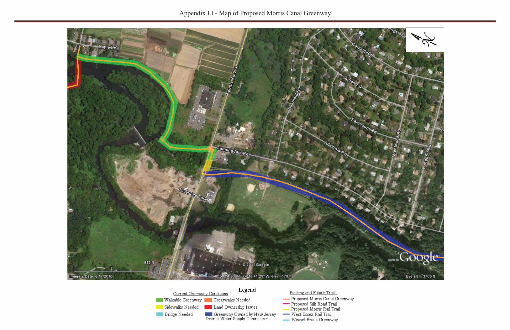
Appendix I.I - Map of Proposed Morris Canal Greenway
�
��
�

Appendix I.I - Map of Proposed Morris Canal Greenway
�
��
�
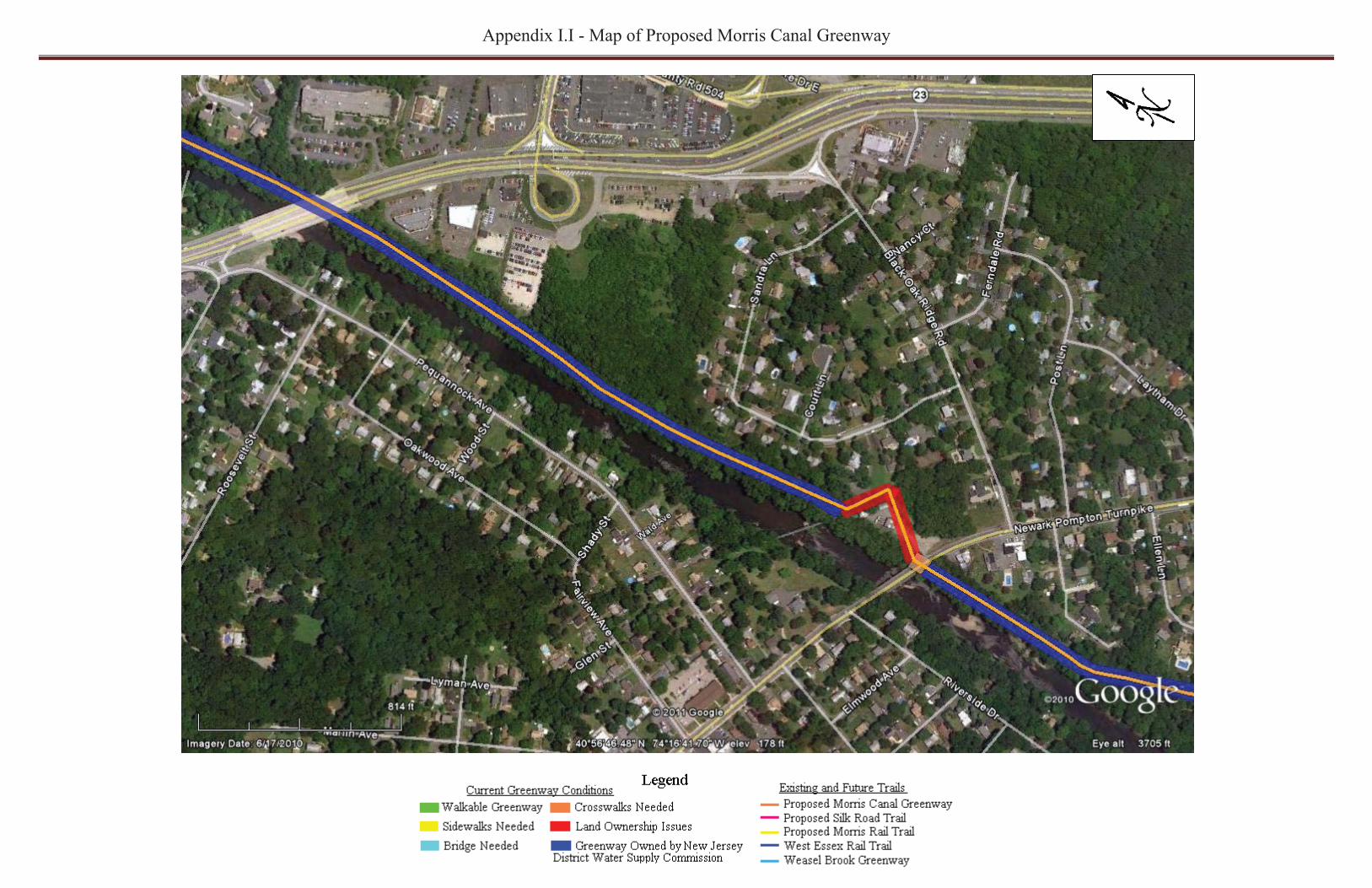
Appendix I.I - Map of Proposed Morris Canal Greenway
�
��
�

Appendix I.I - Map of Proposed Morris Canal Greenway
�
��
`�

Appendix I.I - Map of Proposed Morris Canal Greenway
�
��
�
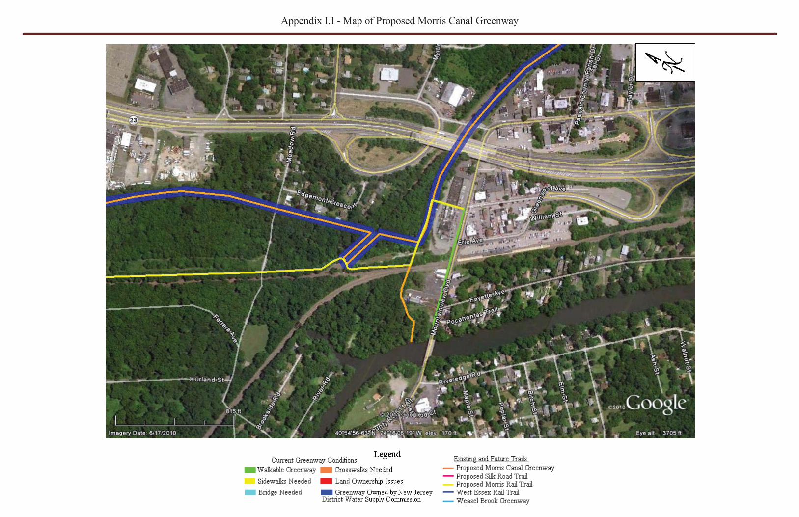
Appendix I.I - Map of Proposed Morris Canal Greenway
�
��
�
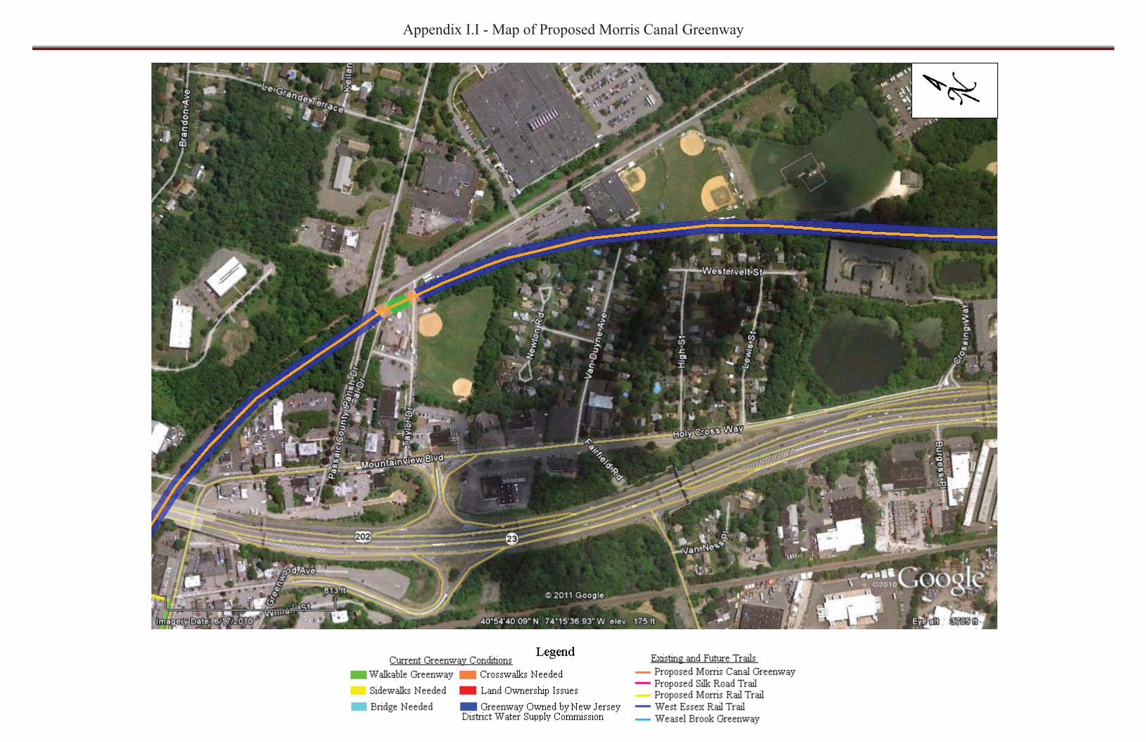
Appendix I.I - Map of Proposed Morris Canal Greenway
�
��
�
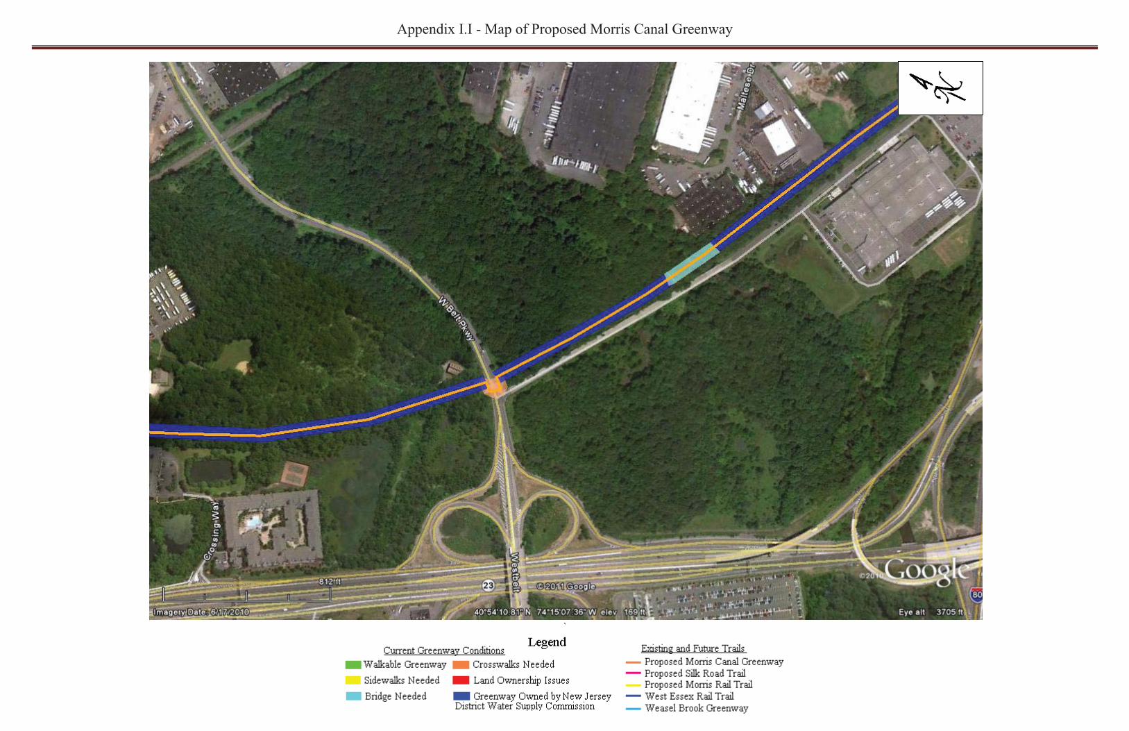
Appendix I.I - Map of Proposed Morris Canal Greenway
�
��
`�

Appendix I.I - Map of Proposed Morris Canal Greenway
�
��
�
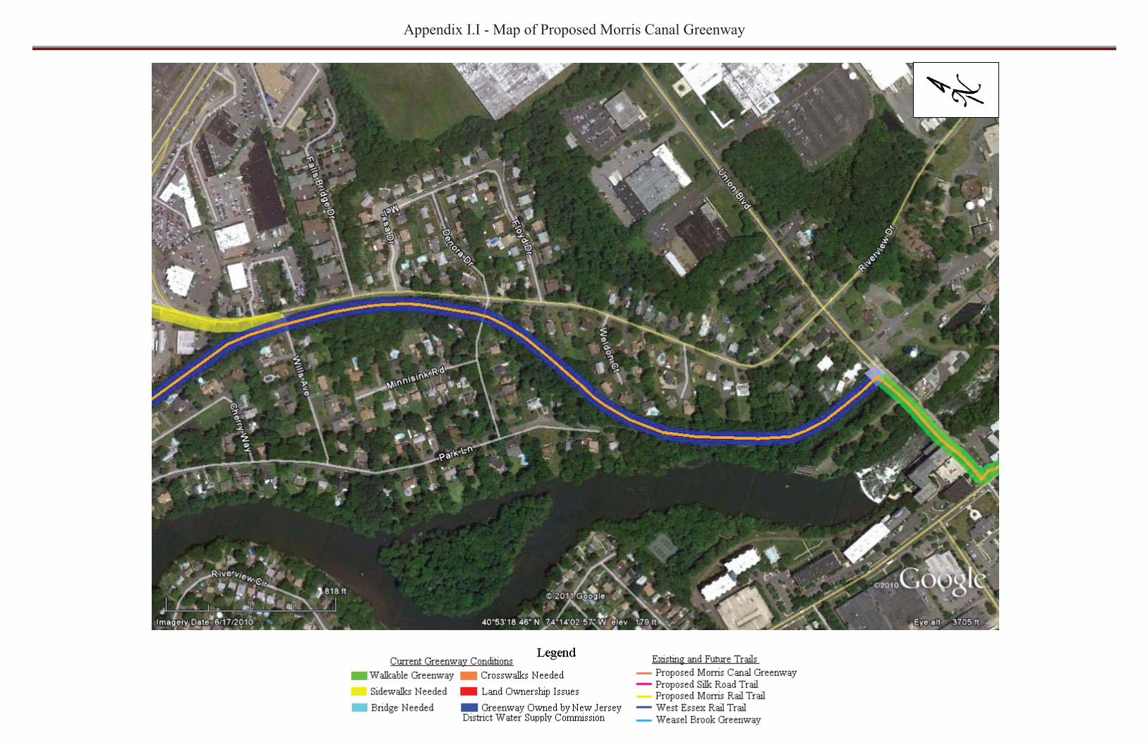
Appendix I.I - Map of Proposed Morris Canal Greenway
�
��
�

Appendix I.I - Map of Proposed Morris Canal Greenway
�
��
�

Appendix I.I - Map of Proposed Morris Canal Greenway
�
��
�

Appendix I.I - Map of Proposed Morris Canal Greenway
�
��
�

Appendix I.I - Map of Proposed Morris Canal Greenway
�
��
�

Appendix I.I - Map of Proposed Morris Canal Greenway
�
��
�

Appendix I.I - Map of Proposed Morris Canal Greenway
�
��
�

Appendix I.I - Map of Proposed Morris Canal Greenway
�
��
�

Appendix I.I - Map of Proposed Morris Canal Greenway
�
��
�

Appendix I.I - Map of Proposed Morris Canal Greenway
�
��
�

Appendix I.I - Map of Proposed Morris Canal Greenway
�
��
�
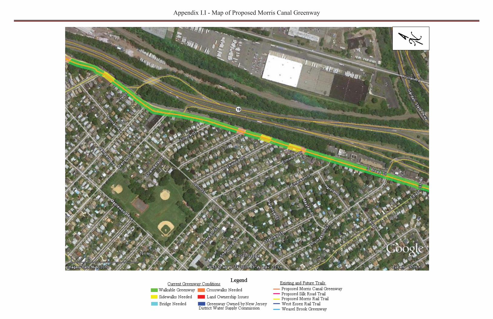
Appendix I.I - Map of Proposed Morris Canal Greenway
�
��
�

Appendix I.I - Map of Proposed Morris Canal Greenway
�
��
�

Appendix I.I - Map of Proposed Morris Canal Greenway
�
��
�

Appendix I.I - Map of Proposed Morris Canal Greenway
�
��
�

Appendix I.I - Map of Proposed Morris Canal Greenway
�
��
Long Term Proposed Extension to the Morris Canal Greenway