morphology and geometry of valles marineris landslides
TRANSCRIPT
ARTICLE IN PRESS
0032-0633/$ - se
doi:10.1016/j.ps
�Correspond85-93.
E-mail addr
Planetary and Space Science 52 (2004) 1011–1022
www.elsevier.com/locate/pss
Morphology and geometry of Valles Marineris landslides
C. Quantin�, P. Allemand, C. Delacourt
Universite Claude Bernard Lyon-1 & ENS Lyon, Laboratoire Sciences de la Terre, UMR 5570 CNRS, Bat geode-6e etage, 2 rue Raphael Dubois,
69622 Villeurbanne Cedex, France
Abstract
The walls of the Valles Marineris canyons are affected by about 45 landslides. The study of these landslides provides a test of the
hypothesis of processes having affected Martian wallslopes after their formation. The dynamics of Valles Marineris landslides are
controversial : either the landslides are interpreted as large debris flows or as dry rock avalanches. Their morphology and their
topography are basic parameters to understand their dynamics. From topographic MOLA data and remote sensing images acquired
with different spatial resolutions (Viking, THEMIS, MOC), the 3D geometry of 45 landslides of Valles Marineris has been studied.
The landslides have been classified in 3 geomorphologic classes from the topography of the landslide deposits: the ‘‘chaotic’’
landslides without well identified structures, the ‘‘structured deposit without debris aprons’’ landslides with tectonic structures and
small roughness at the deposit front and the ‘‘structured deposit with debris aprons’’ which display circular normal faults at the back
of the deposit and several debris aprons at the front of the landslide. The spatial distribution of the three morphological types is in
relation with the confinement of the canyons. The initial volume and the total deposited volume were also measured to compute
volume balances. The deposited volumes range from 50 to 5000 km3: All volume balances display a maximum deficit ranging from5% to 70%. The landslides with the largest deficits take place within an enclosed-canyon (Hebes Chasma). Lacking material
exportation, these deficits could be interpreted as reflecting the porosity of the landslide source. This fact is in agreement with the
hypothesis of a karstic origin of these enclosed-canyons. The Valles Marineris landslides have large mobilities (length/vertical drop)
ranging from 1.8 to 12 implying low coefficients of friction and so fluidization mechanisms. The possible filling up of the porosity by
volatile could be compatible with the fluidization patterns of Valles Marineris landslides.
r 2004 Elsevier Ltd. All rights reserved.
Keywords: Landslide; Mars; Morphology
1. Introduction
Martian wallslopes are affected by numerous land-slides especially within Valles Marineris (V.M). Theanalysis of these Martian morphologies permits first tostudy gravitational processes under different gravitiesand secondly to test the hypothesis of processes thataffected Martian wallslopes after their formation. Thelandslides of Valles Marineris discovered with Vikingpictures were initially interpreted as large wet debrisflows implying the intervention of water in order to
e front matter r 2004 Elsevier Ltd. All rights reserved.
s.2004.07.016
ing author. Tel.: +33-4-72-44-62-40; fax: +33-4-72-44-
ess: [email protected] (C. Quantin).
explain the mobility (ratio between the length of thelandslide and the vertical drop) of these landslides andthe interactions between landslides and water-wornmorphologies (Lucchitta, 1978, 1979, 1987). In contrastto this interpretation, a second study has found that themobilities of Valles Marineris landslides are analogousto dry terrestrial rock avalanches (McEven, 1989). Therole of fluids in the Martian landslide dynamics is notunanimously admitted yet. More than the dynamics ofthe landslide events, the dynamics of their initiation isunknown. On Earth, these processes are related toground conditions within the wallslopes for the intrinsicfactors and to the climate or the seismicity for theexternal factors. The topographic data of Mars OrbiterLaser Altimeter (MOLA) and the high spatial resolution
ARTICLE IN PRESSC. Quantin et al. / Planetary and Space Science 52 (2004) 1011–10221012
images acquired by Mars Orbiter Camera (MOC) fromMars Global Surveyor (MGS) permit a new analysis ofthe final geometry of Valles Marineris landslides. Wepresent the results of a multidisciplinary study oflandslide morphology and geometry using images withdifferent spatial resolutions and altimetric data. Theseresults allow us to propose hypothesis about the groundconditions of Valles Marineris wallslope at landslidetime.
2. Geological setting and data set
2.1. Valles Marineris
Valles Marineris is a 4000 km long east–west troughsystem located in the equatorial zone of Mars on theeastern flank of the Tharsis zone. The width of thecanyon ranges from 50 km to more than 500 km in thecentral part of Valles Marineris. Width variations couldcorrespond to rock strength variations relative to theerosional process (McCauley, 1978). The walls of thecanyon, which have an average slope of 20�; are shapedby normal fault with 6 km of throw (Banerdt et al.,1992). Triangular faceted spurs are visible on the wallsof the canyon and indicate that the faulting is importantto the origin of the canyon. The initiation of tectonicshas been dated from the Hesperian period (Head et al.,2001).The morphology of the canyons has been modified by
external processes like gravitational mechanisms andfluvial events, which have contributed to the presentmorphology after the tectonic episode (Peulvast et al.,2001). The existence of water in the Valles Marinerisarea is demonstrated by the presence of lobate ejectacraters in the neighboring zones such as Lunea Planumor Sinai Planum. These craters indicate the existence offluids at the time of impact in the upper part of the crustto around 5 km depth (Boyce et al., 1996).The trough system also displays a completely enclosed
canyon, Hebes Chasma. Layered deposits within theenclosed canyon suggest emplacement in covered lakes(Nedell and Squyres, 1987). This enclosed troughs couldhave been originated by thermokarstic or karsticprocesses (Spencer and Fanale, 1990; Carr, 1996).
2.2. Data sets
Forty-six landslides were identified and mapped onViking Orbiter images (Table 1). The boundaries oflandslide deposits were defined on the Viking Orbiterimages, on the available MOC images and with DigitalElevation Models (DEM) derived from the interpolationof MOLA profiles. Spatial resolution of MOLA data is300m along the profiles and around 2 km between twoprofiles in Valles Marineris (Smith et al., 2001), the
vertical accuracy is few meters. The quality of DEM isbetter North–South than East–West because of thepolar orbit of the MGS probe. As the walls of VallesMarineris are roughly East–West, the flow of landslideshas been mainly in N–S direction. So, MOLA DEM’sare accurate to study geometrical parameters of thelandslides (Table 1), especially along profiles realized onthe DEM.
3. Characteristics of Valles Marineris landslides
Valles Marineris landslides are prominent featuresbecause the landslides scarps affect all the wallslopesand form re-entrants in the neighboring plateau ofValles Marineris. The dimensions of the landslides areone order in magnitude larger than terrestrial ones. Theaverage deposit area is 938 km2; their average length36 km, their width 32 km (Table 1). The average verticaldrop is 6 km. Those values are not observed on Earthexcepted in submarine slides. However, the relationshipsbetween geometrical parameters of Valles Marinerislandslides are the same as for terrestrial ones despite thescale difference (Legros, 2002). The thickness of thelandslide deposits decreases from about 2 km at the footof the scarp to 100m at the front of the landslide. Thesurface of the landslide deposit is characterized by ahectometric scale roughness, which is observed on theViking images and topographic profiles.In this section, the particular features of Valles
Marineris landslides are described. A classification ofValles Marineris landslides based on the morphology oftheir deposits is proposed. The distribution of thedifferent types within Valles Marineris is then studied.The volumes of the landslides are presented and volumebalances between the landslide deposits and source areasare discussed. Finally, an analysis of the landslidedynamics is presented based on mobility measurementand comparison with terrestrial landslides.
3.1. Classification of Martian landslides from their
morphology
A landslide classification is proposed according to themorphological and topographic features of the landslidedeposits. Four morphological types are defined: (1)chaotic (C), (2) structured deposit without debris aprons(SD), (3) structured deposit with debris aprons(SDWDA) and (4) hanging (H).(1) The C type (11 landslides) displays rough deposits
without well-identified tectonic structures (Fig. 1). Theamplitude of the roughness could reach 1 km (Fig. 1)and the roughness is not organized. The depositssometimes display some local linear topographiesparallel to the landslide scarp but these topographiesare not continuous along the width of the landslide.
ARTIC
LEIN
PRES
STable 1
Geometrical features of Valles Marineris landslides
IDa Location Morphological Deposit Length Vertical Coefficient Depositf Widthg Widthh Factor Initial Landslide Materialtypeb area ðkm2Þ ðkmÞ
c drop ðkmÞd of frictione slope ð0Þ (km) of the canyon (km) of confinement volume ðkm3Þ volume ðkm3Þ balance (%)
1 Tithonium Chasma S.D.W.D.A 702 12.4 6.9 0.554 11.1 6.4 62.11 0.10 550.79 389.07 29.362 Tithonium Chasma S.D:W.D.A 379.44 25.23 6.4 0.254 4.4 22.1 34.3 0.64 155.51 151.5 2.583 Tithonium Chasma S.D.W.D.A 178.83 22.69 6.4 0.283 4 14.4 38 0.38 100.49 73.34 27.024 Tithonium Chasma S.D. 806 41.13 7 0.171 7.9 29 45 0.64 1167.05 848.43 27.35 Tithonium Chasma S.D. 513.54 21.6 6.9 0.319 8.6 39.91 40.8 0.98 1093.99 663.61 39.346 Tithonium Chasma C. 101.97 10.21 2.9 0.284 6 19.55 13.2 1.48 204.39 201.12 1.67 Tithonium Chasma S.D. 383.49 29.6 5.6 0.189 7.8 19.33 35.5 0.54 736.79 439.52 40.348 Tithonium Chasma S.D. 56.7 10.3 4.9 0.475 3.6 8.7 19.6 0.44 196.94 129.48 34.259 Ius Chasma C. 678.33 29.1 6.5 0.225 5.7 3.12 46.2 0.68 1495.67 1021.7 31.6810 Ius Chasma C. 3735.72 51.38 6.8 0.133 �1.1 96.31 54 1.78 5977.78 4835.72 19.111 Ius Chasma C. 1464.75 45.6 7.7. 0.17 13 40.68 59 0.69 1960.3 1520.97 22.4112 Ius Chasma S.D. 1151.64 53 7.9 0.148 3.2 43.23 54.3 0.80 1132.12 1068.15 5.6513 Ius Chasma S.D. 658.89 35.22 7.9 0.225 4.4 19.58 70.6 0.28 562.42 534.76 4.9214 Ius Chasma S.D.W.D.A 1141.47 83 8.5 0.103 4.9 44.49 100 0.44 397.25 3079.77 22.4615 Hebes Chasma C. 489.33 19.4 7.2 0.371 8.8 24.1 46.2 0.52 335.76 128.92 61.616 Hebes Chasma C. 966.33 48.3 7.5 0155 1.9 31.4 36.6 0.86 1445.4 751.84 47.9817 Hebes Chasma C. 1411.92 59.22 8 0.135 2.5 22.02 63 0.35 1850.29 599.72 67.5818 Hebes Chasma C. 1386.45 36.8 6 0.163 4.8 61.7 33 1.87 319.62 102.62 67.8919 Hebes Chasma C. 1796.67 37.98 7 0.184 1.8 72.3 35.5 2.04 6361.2 2017.59 68.2820 Candor Chasma C. 487.98 32.9 5.4 0.165 4.3 24.4 51.6 0.47 165.4 161.24 2.5221 Candor Chasma S.D. 853.47 42.705 6.8 0.159 3.7 32.10 63.6 0.50 230.67 224.39 2.7222 Ophir Chasma S.D. 1232.37 54.21 5.8 0.107 2.9 38.46 60.4 0.64 1743.64 1496.22 14.1923 Ophir Chasma S.D.W.D.A 3416.22 66.3 8 0.12 5.1 69.97 100 0.70 9081.83 5204.68 42.6924 Melas Chasma S.D.W.D.A 1398.24 62.74 7.9 0.126 3.2 46.5 100 0.46 1646.10 1451.19 11.8425 Melas Chasma S.D. 516.24 48.69 7.6 0.157 0.7 17.5 100 0.18 248.63 193.07 22.3426 Melas Chasma H. 740.88 26.55 8.6 0.322 4.2 24.29 100 0.24 376.20 237.29 36.9227 Melas Chasma S.D.W.D.A 2099.16 51.38 6.1 0.118 1.4 55.4 94.6 0.59 2420.79 1630.64 32.6428 Melas Chasma S.D. 191.79 15.09 6.7 0.445 10.5 17.16 69 0.25 128.76 101.71 2129 Melas Chasma S.D.W.D.A 170.55 12.7 6.7 0.529 14.5 12.48 56.6 0.22 391.07 329.48 15.7530 Melas Chasma S.D.W.D.A 186.4 18.49 6.7 0.363 10.9 15.56 56.5 0.28 423.75 265.98 37.2331 Coprates Chasma S.D.WD.A 1573.02 69.01 9.3 0.135 2.1 34.77 60.2 0.58 637.77 458.09 28.1732 Coprates Chasma S.D.W.D.A 1927.8 60.7 5 0.082 2.4 57.91 99.4 0.58 500 346.52 30.6933 Coprates Chasma H. 296.91 29.7 9.7 0.327 13.7 11.13 99.4 0.11 60.6 50.4 16.8334 Coprates Chasma S.D. 4435.83 61.8 7 0.113 3.9 107.56 65.6 1.64 6181 4915.29 20.4735 Coprates Chasma C. 442.89 30.6 4.5 0.147 6.5 22.88 37 0.62 261.04 199.45 23.5936 Coprates Chasma S.D.WD.A 1348.29 61.19 8 0.13 3.3 48.31 68.3 0.71 1583.46 1021.61 35.4937 Coprates Chasma S.D.W.D.A 2082 48 8 0.166 0.5 40 100 0.40 910.12 671.33 26.1838 Gangis Chasma S.D.W.D.A 934.29 53.54 5.6 0.105 2.8 31.57 100 0.32 698.72 404.81 42.0639 Gangis Chasma S.D. 869.31 30.1257 5.5 0.182 7.6 34.45 100 034 349.9 279.12 20.2240 Gangis Chasma S.D.W.D.A 258.48 26.81 5.5 0.205 1.5 19.5 100 0.20 307.24 194.88 36.5741 Gangis Chasma S.D.W.D.A 699.93 38.5 5.5 0.142 2.6 37.8 64.4 0.59 851.59 464.6 45.4442 Gangis Chasma S.D.W.D.A 2334.69 63.83 5 0.078 2.1 73.08 92 0.79 1003.39 556.67 44.5243 Gangis Chasma S.D.W.D.A 679.23 29.95 4 0.133 7.1 27.55 92 0.30 316.23 232.23 26.5644 Gangis Chasma S.D.W.D.A 321.39 32.47 5.2 0.16 0 12.44 56 0.22 179.2 74.75 58.2845 Gangis Chasma S.D.W.D.A 226.89 20.05 2.5 0.124 0.4 14.4 49.2 0.29 15.98 15.26 4.51
aNumber referring to the Fig. 7.bHanging (H.) chaotic (C.), structured deposit without debirs approas (S.D.), structured deposit with debris (S.D.W.D.A).cHorizontal distance from the scarp to front of landslide.dFrom the top of the landslide scarp to floor of the canyon at the landslide front.eVertical drop/length.fAveraged slope from the foot of the landslide scarp to front of landslide.gWidth of the re-entrant of the landslide scarp.hFrom top of wallslope to top of opposite wall. A maximum width of 100 km was used.
C.
Qu
an
tinet
al.
/P
lan
etary
an
dS
pa
ceS
cience
52
(2
00
4)
10
11
–1
02
21013
ARTICLE IN PRESS
Fig. 1. Morphological features of the chaotic type (C): (a) Viking environment of the example (landslide in Ius Chasma no 10, Table 1) and location
of the profile A–B. (b) Topographic profile A–B. The landslide deposit fills up the whole canyon and covers the lower part of the opposite wall.
Fig. 2. Morphological features of the structured deposit without debris apron (SD) type: (a) Part of day time THEMIS (Mars Odyssey Mission)
mosaic (landslide in Coprates Chasma no 34, Table 1) and location of the profile A–B. (b) Topographic profile A–B. Notice the extensive structures
at the back of the landslide deposit and the unorganized roughness at the toe.
C. Quantin et al. / Planetary and Space Science 52 (2004) 1011–10221014
(2) The structured deposits without debris aprons(SD) type (12 landslides) display tectonic structures atthe back of the deposit whereas the front showsunorganized roughness (Fig. 2). Indeed, the topogra-phies located at the back of the landslide result fromnormal fault structures like often observed on terrestriallandslide areas. The distal part of the deposit is affectedby small-scale roughness in order to 100m in height.(3) The structured landslides with debris aprons
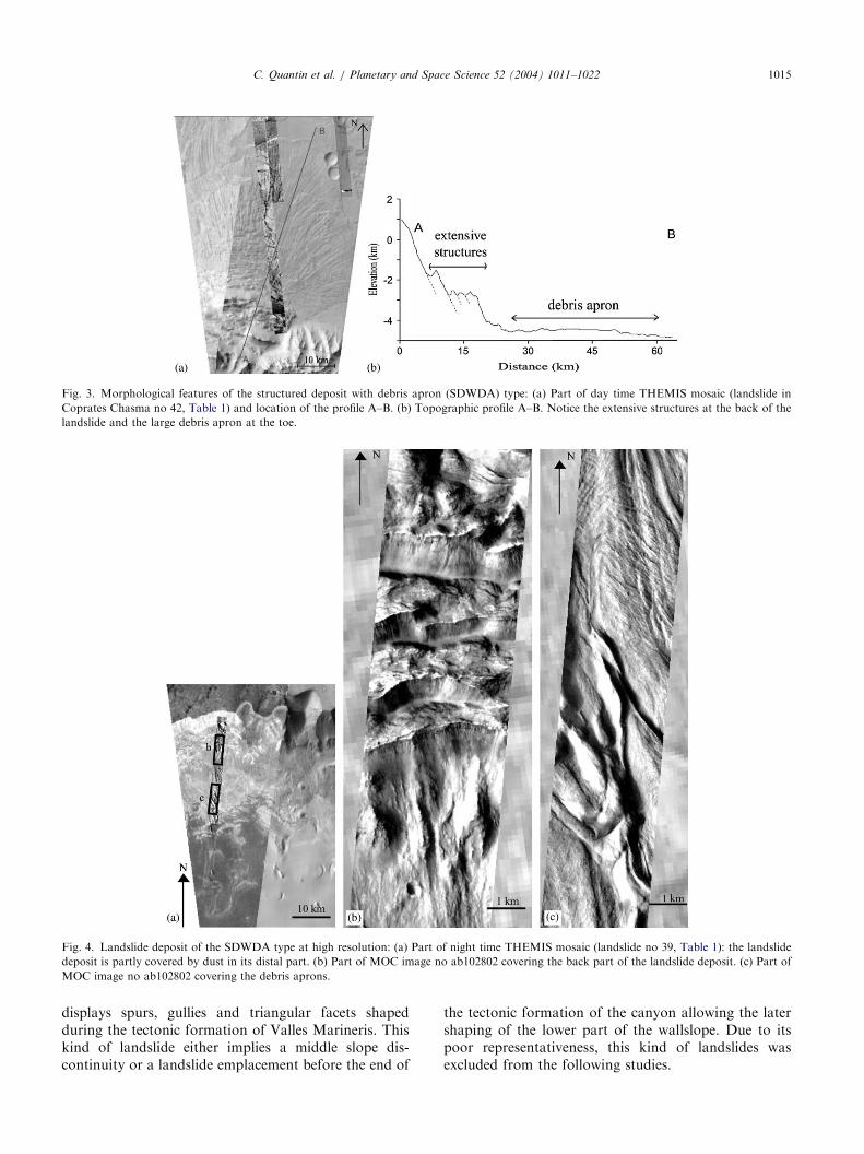
(SDWDA) type (20 landslides) also shows well-identi-fied extensive structures at the back of the depositwhereas the main part of the deposit consists of largedebris aprons (Fig. 3). The structures of the back partcorrespond to circular normal faults (Fig. 4) wellobserved on available MOC images crossing this kindof landslide (Fig. 4). The distal and main parts of the
deposit are constituted by one or more large debrisaprons. These debris aprons show longitudinal ridgesobserved in details on high-resolution images (Fig. 4).These morphologies would result from high velocitymechanisms (Shreve, 1966; Lucchitta, 1979). The debrisaprons that are visible on DEM (Fig. 5) have a lobateshape and a thickness of 200m. The emplacement ofthese debris aprons occurs at high velocities becausethey sometimes overlap other aprons. For example, thelandslide of Fig. 6 coming from the north wall overlapsan other 200m high apron. According to Chow’spotential energy equation (Chow, 1959), this run up of200m implies a velocity at least of 38m/s.(4) The hanging (H) type (2 landslides) corresponds to
landslides affecting only the upper part of the wallslope(Fig. 6). We note that the lower part of the wallslope
ARTICLE IN PRESS
Fig. 4. Landslide deposit of the SDWDA type at high resolution: (a) Part of night time THEMIS mosaic (landslide no 39, Table 1): the landslide
deposit is partly covered by dust in its distal part. (b) Part of MOC image no ab102802 covering the back part of the landslide deposit. (c) Part of
MOC image no ab102802 covering the debris aprons.
Fig. 3. Morphological features of the structured deposit with debris apron (SDWDA) type: (a) Part of day time THEMIS mosaic (landslide in
Coprates Chasma no 42, Table 1) and location of the profile A–B. (b) Topographic profile A–B. Notice the extensive structures at the back of the
landslide and the large debris apron at the toe.
C. Quantin et al. / Planetary and Space Science 52 (2004) 1011–1022 1015
displays spurs, gullies and triangular facets shapedduring the tectonic formation of Valles Marineris. Thiskind of landslide either implies a middle slope dis-continuity or a landslide emplacement before the end of
the tectonic formation of the canyon allowing the latershaping of the lower part of the wallslope. Due to itspoor representativeness, this kind of landslides wasexcluded from the following studies.

ARTICLE IN PRESS
Fig. 5. Landslide debris aprons: (a) Part of day time THEMIS mosaic (landslide in Gangis Chasma no 45, Table 1) and location of the profile A–B.
(b) DEM of the debris apron: the thickness of the deposit is about 200m. (c) Topographic profile A–B. The landslide coming from the north wall
overlaps another debris apron coming from the south wall.
Fig. 6. Morphological feature of the H-type: (a) Viking environment of the example (landslide in Coprates Chasma no 26, Table 1) and location of
the profile A–B. (b) Topographic profile A–B. The slope of the landslide scarp is larger than the slope of the basal part of the wallslope unaffected by
the landslide which corresponds to the average slope of Valles Marineris wallslopes.
C. Quantin et al. / Planetary and Space Science 52 (2004) 1011–10221016
3.2. Distribution of morphological types within Valles
Marineris
The landslides are located in all main open canyons ofValles Marineris and within enclosed canyons likeHebes Chasma. The spatial distribution of the morpho-logical types of landslides is shown on the Fig. 7. The Clandslides are mainly located within narrow canyons like
Ius Chasma and in the enclosed Hebes Chasma. TheSDWDA landslides are mainly located in GangisChasma and on the walls of the central parts of VallesMarineris. The SD landslides are distributed all over theValles Marineris area without evident local concentra-tions. The distribution of C and SDWA types seems tobe related to the width of the canyon where theyare located. To test this hypothesis, a ‘‘factor of
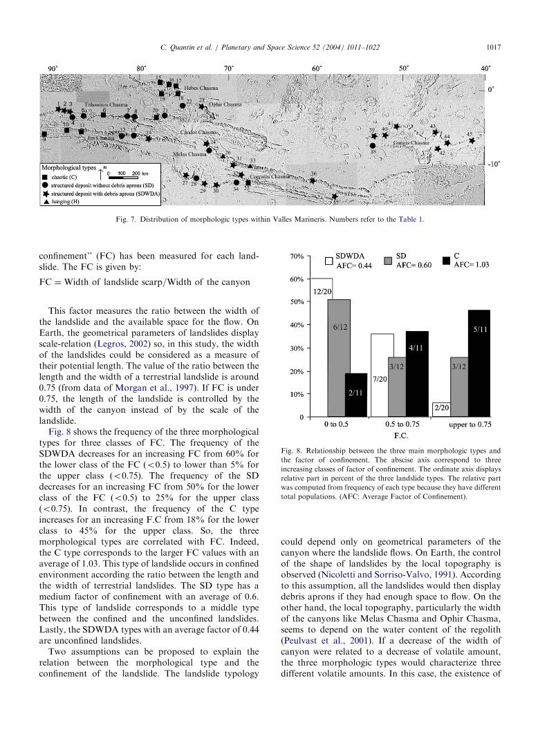
ARTICLE IN PRESS
Fig. 7. Distribution of morphologic types within Valles Marineris. Numbers refer to the Table 1.
Fig. 8. Relationship between the three main morphologic types and
the factor of confinement. The abscise axis correspond to three
increasing classes of factor of confinement. The ordinate axis displays
relative part in percent of the three landslide types. The relative part
was computed from frequency of each type because they have different
total populations. (AFC: Average Factor of Confinement).
C. Quantin et al. / Planetary and Space Science 52 (2004) 1011–1022 1017
confinement’’ (FC) has been measured for each land-slide. The FC is given by:
FC ¼Width of landslide scarp=Width of the canyon
This factor measures the ratio between the width ofthe landslide and the available space for the flow. OnEarth, the geometrical parameters of landslides displayscale-relation (Legros, 2002) so, in this study, the widthof the landslides could be considered as a measure oftheir potential length. The value of the ratio between thelength and the width of a terrestrial landslide is around0.75 (from data of Morgan et al., 1997). If FC is under0.75, the length of the landslide is controlled by thewidth of the canyon instead of by the scale of thelandslide.Fig. 8 shows the frequency of the three morphological
types for three classes of FC. The frequency of theSDWDA decreases for an increasing FC from 60% forthe lower class of the FC ðo0:5Þ to lower than 5% forthe upper class ðo0:75Þ: The frequency of the SDdecreases for an increasing FC from 50% for the lowerclass of the FC ðo0:5Þ to 25% for the upper classðo0:75Þ: In contrast, the frequency of the C typeincreases for an increasing F.C from 18% for the lowerclass to 45% for the upper class. So, the threemorphological types are correlated with FC. Indeed,the C type corresponds to the larger FC values with anaverage of 1.03. This type of landslide occurs in confinedenvironment according the ratio between the length andthe width of terrestrial landslides. The SD type has amedium factor of confinement with an average of 0.6.This type of landslide corresponds to a middle typebetween the confined and the unconfined landslides.Lastly, the SDWDA types with an average factor of 0.44are unconfined landslides.Two assumptions can be proposed to explain the
relation between the morphological type and theconfinement of the landslide. The landslide typology
could depend only on geometrical parameters of thecanyon where the landslide flows. On Earth, the controlof the shape of landslides by the local topography isobserved (Nicoletti and Sorriso-Valvo, 1991). Accordingto this assumption, all the landslides would then displaydebris aprons if they had enough space to flow. On theother hand, the local topography, particularly the widthof the canyons like Melas Chasma and Ophir Chasma,seems to depend on the water content of the regolith(Peulvast et al., 2001). If a decrease of the width ofcanyon were related to a decrease of volatile amount,the three morphologic types would characterize threedifferent volatile amounts. In this case, the existence of
ARTICLE IN PRESS
Fig. 9. Illustration of the computing Method of landslide volumes: (a)
3D surface view of a landslides area (Viking image overlapped on
MOLA DEM). The black straight line corresponds to the topographic
profile of the landslide area on the Fig. 9b and the white straight lines
correspond to topographic profiles of unslided wallslopes on each side
of the landslide area. (b) Overlap of two topographic profiles: the black
one corresponds to the landslide areas and the Grey one is a linear
interpolation of both white profiles of the Fig. 9a in order to obtain the
pre-landslide geometry. The difference between both profiles corre-
sponds to the eroded volume for the part under the pre-landslide
surface and to the settled volume for the above part. The dotted line
represents the part of deposited volume which is under the pre-
landslide profile (filling up volume).
C. Quantin et al. / Planetary and Space Science 52 (2004) 1011–10221018
debris aprons could be controlled by the presence offluids rather than the available space.
3.3. Landslide volumes and volume balance
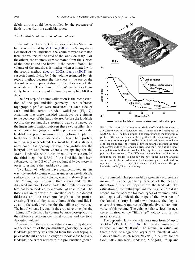
The volume of about 30 landslides of Valles Marinerishas been estimated by McEven (1989) from Viking data.For most of the landslides, the volumes were estimatedfrom the volume of the void of the landslide scarp. Forthe others, the volumes were estimated from the surfaceof the deposit and the height at the deposit front. Thevolume of the landslides is smaller when estimated withthe second method (Legros, 2002). Legros (2002) hassuggested multiplying by 7 the volume estimated by thissecond method because the thickness at the toe of thedeposit is not representative of the thickness of thewhole deposit. The volumes of the 46 landslides of thisstudy have been computed from topographic MOLAdata.The first step of volume estimation is the reconstruc-
tion of the pre-landslide geometry. Two referencetopographic profiles were measured on each side ofeach landslide across unslided wallslopes (Fig. 9).Assuming that these unslided wallslopes were similarto the geometry of the landslide area before the landslideoccurs, the pre-landslide geometry was constructed bythe linear interpolation between these two profiles. In asecond step, topographic profiles perpendicular to thelandslide scarp were measured starting from the plateauto the toe of the landslide deposit. Then, These profileswere linearly interpolated. For most landslides, strikingnorth-south, the spacing between the profiles for theinterpolation was 300m whereas this spacing for theseveral landslides with other orientation was 2 km. Inthe third step, the DEM of the landslide has beensubtracted to the DEM of the pre-landslide geometry inorder to estimate the landslide volumes.Two kinds of volumes have been computed in this
way: the eroded volume which is under the pre-landslidesurface and the settled volume, which is above (Fig. 9).The ‘‘filling up’’ volumes that correspond to thedisplaced material located under the pre-landslide sur-face has been modeled by a quarter of an ellipsoid. Thethree axes are the width of landslide scarp, the depositthickness and the re-entrant length at the profilescrossing. The total deposited volume of the landslide isequal to the settled volume plus the ‘‘filling up’’ volume.The initial volume is equal to the eroded volume plus the‘‘filling up’’ volume. The volume balance corresponds tothe difference between the initial volume and the totaldeposited volume.The errors in these volume estimations mostly depend
on the exactness of the pre-landslide geometry. As a pre-landslide geometry was defined from the local topogra-phies of the hillslopes and canyon’s floors close to everylandslide, the errors related to the pre-landslide geome-
try are limited. This pre-landslide geometry represents amaximum volume geometry because of the possibledissection of the wallslope before the landslide. Theestimation of the ‘‘filling up’’ volume by an ellipsoid is asecond source of error for both types of volume (initialand deposited). Indeed, the shape of the lower part ofthe landslide scarp is unknown because the depositcovers this zone. A quarter of ellipsoid gives a maximumvalue of this volume. The volume balance does not needthe estimation of the ‘‘filling up’’ volume and is thenmore accurate.The deposited landslide volumes range from 50 up to
5000 km3 (Table 1, Fig. 10). The initial volumes rangebetween 60 and 9000 km3: The maximum values arethree orders of magnitude larger than terrestrial land-slides volumes, which reach 50 km3 (i.e. 50 km3 for theGobi-Atlay sub-aerial landslide, Mongolia, Philip and
ARTICLE IN PRESS
Fig. 10. Distribution of the volumes and material balances within Valles Marineris. The areas of the circles are proportional to the settled volumes.
Grey levels correspond to increasing classes of material deficit.
Fig. 11. Relationships between volume and coefficient of friction for
terrestrial rock avalanches and Martian landslides (Table 1). Martian
and terrestrial landslides correspond to two distinct scatter plots. The
data of terrestrial coefficients of friction from: Evans et al. (1989,
1994), Hewitt (1988, 1998), Mudge (1965), Nicoletti and Sorriso-Valvo
(1991), Philip and Ritz (1999), Shreve (1966).
C. Quantin et al. / Planetary and Space Science 52 (2004) 1011–1022 1019
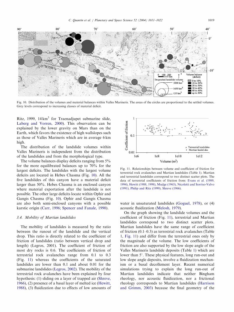
Ritz, 1999, 14 km3 for Traenadjupet submarine slide,Laberg and Vorren, 2000). This observation can beexplained by the lower gravity on Mars than on theEarth, which favors the existence of high wallslopes suchas those of Valles Marineris which are in average 6 kmhigh.The distribution of the landslide volumes within
Valles Marineris is independent from the distributionof the landslides and from the morphological type.The volume balances display deficits ranging from 5%
for the more equilibrated balances up to 70% for thelargest deficits. The landslides with the largest volumedeficits are located in Hebes Chasma (Fig. 10). All thefive landslides of this canyon have a material deficitlarger than 50%. Hebes Chasma is an enclosed canyonwhere material exportation after the landslide is notpossible. The other large deficits locate within Ophir andGangis Chasma (Fig. 10). Ophir and Gangis Chasmaare also both semi-enclosed canyons with a possiblekarstic origin (Carr, 1996; Spencer and Fanale, 1990).
3.4. Mobility of Martian landslides
The mobility of landslides is measured by the ratiobetween the runout of the landslide and the verticaldrop. This ratio is directly related to the coefficient offriction of landslides (ratio between vertical drop andlength) (Legros, 2001). The coefficient of friction ofmost dry rocks is 0.6. The coefficients of friction ofterrestrial rock avalanches range from 0.1 to 0.3(Fig. 11) whereas the coefficients of the saturatedlandslides are lower than 0.1 and about 0.01 for thesubmarine landslides (Legros, 2002). The mobility of theterrestrial rock avalanches have been explained by fourhypothesis: (1) sliding on a layer of trapped air (Shreve,1966), (2) presence of a basal layer of melted ice (Hewitt,1988), (3) fluidization due to effects of low amounts of
water in unsaturated landslides (Goguel, 1978), or (4)acoustic fluidization (Melosh, 1979).On the graph showing the landslide volumes and the
coefficient of friction (Fig. 11), terrestrial and Martianlandslides correspond to two distinct scatter plots.Martian landslides have the same range of coefficientof friction (0.1–0.3) as terrestrial rock avalanches (Table1, Fig. 11) and differ from the terrestrial ones only bythe magnitude of the volume. The low coefficients offriction are also supported by the low slope angle of theValles Marineris landslide deposits (Table 1) which arelower than 5�: These physical features, long run-out andlow slope angle deposits, involve a fluidization mechan-ism or a basal decollement layer. Recent numericalsimulations trying to explain the long run-out ofMartian landslides indicate that neither Binghamrheology, nor acoustic fluidization, nor a frictionalrheology corresponds to Martian landslides (Harrisonand Grimm, 2003) because the final geometry of the
ARTICLE IN PRESSC. Quantin et al. / Planetary and Space Science 52 (2004) 1011–10221020
models is different from the observations. The explana-tion for large mobility of terrestrial rock avalanches andValles Marineris landslides is not unanimously acceptedas yet.The most cited rock avalanche similar to Martian
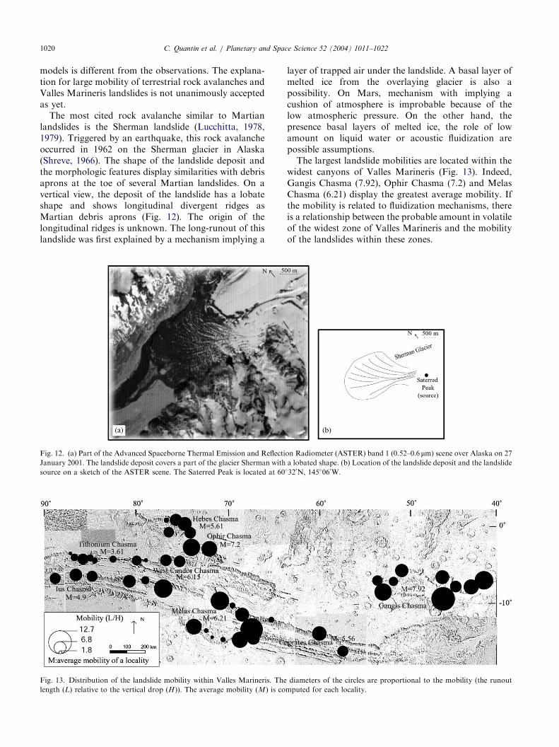
landslides is the Sherman landslide (Lucchitta, 1978,1979). Triggered by an earthquake, this rock avalancheoccurred in 1962 on the Sherman glacier in Alaska(Shreve, 1966). The shape of the landslide deposit andthe morphologic features display similarities with debrisaprons at the toe of several Martian landslides. On avertical view, the deposit of the landslide has a lobateshape and shows longitudinal divergent ridges asMartian debris aprons (Fig. 12). The origin of thelongitudinal ridges is unknown. The long-runout of thislandslide was first explained by a mechanism implying a
Fig. 12. (a) Part of the Advanced Spaceborne Thermal Emission and Reflecti
January 2001. The landslide deposit covers a part of the glacier Sherman with
source on a sketch of the ASTER scene. The Saterred Peak is located at 60
Fig. 13. Distribution of the landslide mobility within Valles Marineris. The
length ðLÞ relative to the vertical drop ðHÞ). The average mobility ðMÞ is co
layer of trapped air under the landslide. A basal layer ofmelted ice from the overlaying glacier is also apossibility. On Mars, mechanism with implying acushion of atmosphere is improbable because of thelow atmospheric pressure. On the other hand, thepresence basal layers of melted ice, the role of lowamount on liquid water or acoustic fluidization arepossible assumptions.The largest landslide mobilities are located within the
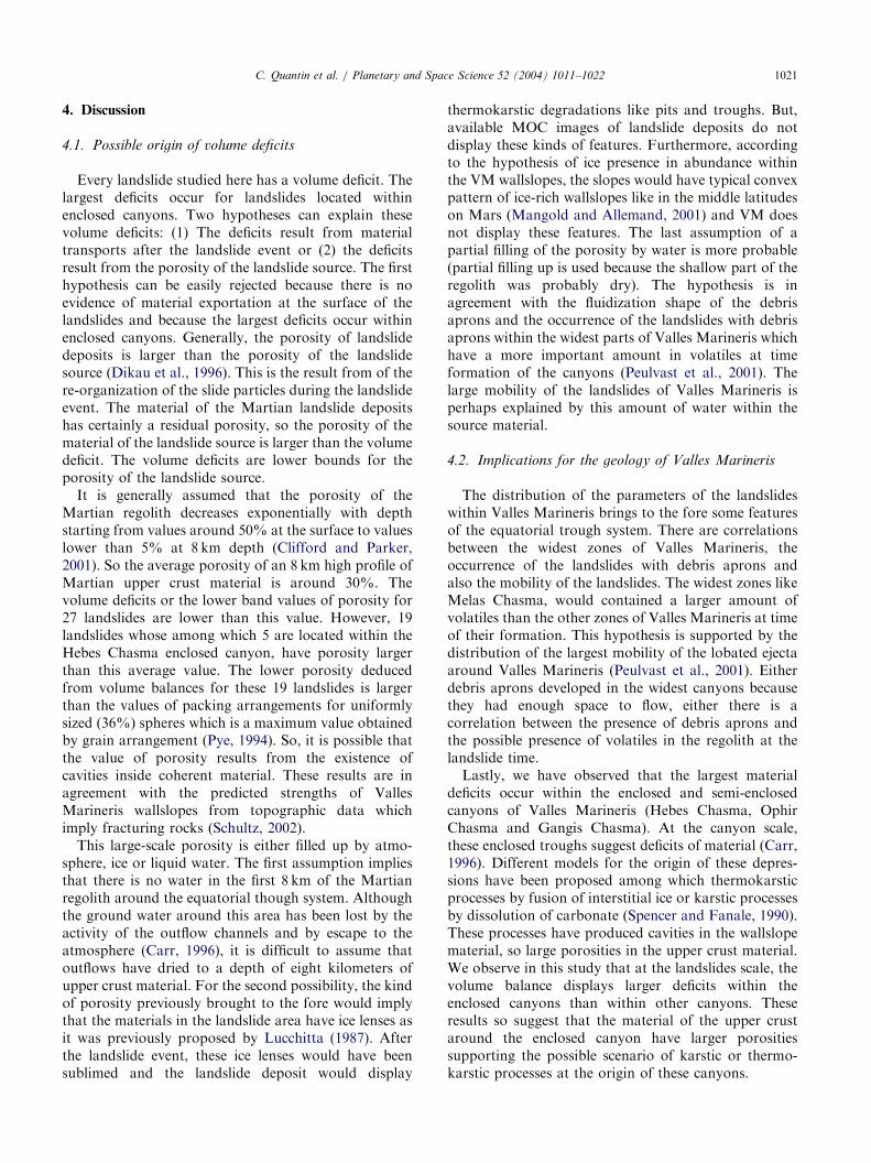
widest canyons of Valles Marineris (Fig. 13). Indeed,Gangis Chasma (7.92), Ophir Chasma (7.2) and MelasChasma (6.21) display the greatest average mobility. Ifthe mobility is related to fluidization mechanisms, thereis a relationship between the probable amount in volatileof the widest zone of Valles Marineris and the mobilityof the landslides within these zones.
on Radiometer (ASTER) band 1 (0.52–0:6mm) scene over Alaska on 27a lobated shape. (b) Location of the landslide deposit and the landslide�320N; 145�060W:
diameters of the circles are proportional to the mobility (the runout
mputed for each locality.
ARTICLE IN PRESSC. Quantin et al. / Planetary and Space Science 52 (2004) 1011–1022 1021
4. Discussion
4.1. Possible origin of volume deficits
Every landslide studied here has a volume deficit. Thelargest deficits occur for landslides located withinenclosed canyons. Two hypotheses can explain thesevolume deficits: (1) The deficits result from materialtransports after the landslide event or (2) the deficitsresult from the porosity of the landslide source. The firsthypothesis can be easily rejected because there is noevidence of material exportation at the surface of thelandslides and because the largest deficits occur withinenclosed canyons. Generally, the porosity of landslidedeposits is larger than the porosity of the landslidesource (Dikau et al., 1996). This is the result from of there-organization of the slide particles during the landslideevent. The material of the Martian landslide depositshas certainly a residual porosity, so the porosity of thematerial of the landslide source is larger than the volumedeficit. The volume deficits are lower bounds for theporosity of the landslide source.It is generally assumed that the porosity of the
Martian regolith decreases exponentially with depthstarting from values around 50% at the surface to valueslower than 5% at 8 km depth (Clifford and Parker,2001). So the average porosity of an 8 km high profile ofMartian upper crust material is around 30%. Thevolume deficits or the lower band values of porosity for27 landslides are lower than this value. However, 19landslides whose among which 5 are located within theHebes Chasma enclosed canyon, have porosity largerthan this average value. The lower porosity deducedfrom volume balances for these 19 landslides is largerthan the values of packing arrangements for uniformlysized (36%) spheres which is a maximum value obtainedby grain arrangement (Pye, 1994). So, it is possible thatthe value of porosity results from the existence ofcavities inside coherent material. These results are inagreement with the predicted strengths of VallesMarineris wallslopes from topographic data whichimply fracturing rocks (Schultz, 2002).This large-scale porosity is either filled up by atmo-
sphere, ice or liquid water. The first assumption impliesthat there is no water in the first 8 km of the Martianregolith around the equatorial though system. Althoughthe ground water around this area has been lost by theactivity of the outflow channels and by escape to theatmosphere (Carr, 1996), it is difficult to assume thatoutflows have dried to a depth of eight kilometers ofupper crust material. For the second possibility, the kindof porosity previously brought to the fore would implythat the materials in the landslide area have ice lenses asit was previously proposed by Lucchitta (1987). Afterthe landslide event, these ice lenses would have beensublimed and the landslide deposit would display
thermokarstic degradations like pits and troughs. But,available MOC images of landslide deposits do notdisplay these kinds of features. Furthermore, accordingto the hypothesis of ice presence in abundance withinthe VM wallslopes, the slopes would have typical convexpattern of ice-rich wallslopes like in the middle latitudeson Mars (Mangold and Allemand, 2001) and VM doesnot display these features. The last assumption of apartial filling of the porosity by water is more probable(partial filling up is used because the shallow part of theregolith was probably dry). The hypothesis is inagreement with the fluidization shape of the debrisaprons and the occurrence of the landslides with debrisaprons within the widest parts of Valles Marineris whichhave a more important amount in volatiles at timeformation of the canyons (Peulvast et al., 2001). Thelarge mobility of the landslides of Valles Marineris isperhaps explained by this amount of water within thesource material.
4.2. Implications for the geology of Valles Marineris
The distribution of the parameters of the landslideswithin Valles Marineris brings to the fore some featuresof the equatorial trough system. There are correlationsbetween the widest zones of Valles Marineris, theoccurrence of the landslides with debris aprons andalso the mobility of the landslides. The widest zones likeMelas Chasma, would contained a larger amount ofvolatiles than the other zones of Valles Marineris at timeof their formation. This hypothesis is supported by thedistribution of the largest mobility of the lobated ejectaaround Valles Marineris (Peulvast et al., 2001). Eitherdebris aprons developed in the widest canyons becausethey had enough space to flow, either there is acorrelation between the presence of debris aprons andthe possible presence of volatiles in the regolith at thelandslide time.Lastly, we have observed that the largest material
deficits occur within the enclosed and semi-enclosedcanyons of Valles Marineris (Hebes Chasma, OphirChasma and Gangis Chasma). At the canyon scale,these enclosed troughs suggest deficits of material (Carr,1996). Different models for the origin of these depres-sions have been proposed among which thermokarsticprocesses by fusion of interstitial ice or karstic processesby dissolution of carbonate (Spencer and Fanale, 1990).These processes have produced cavities in the wallslopematerial, so large porosities in the upper crust material.We observe in this study that at the landslides scale, thevolume balance displays larger deficits within theenclosed canyons than within other canyons. Theseresults so suggest that the material of the upper crustaround the enclosed canyon have larger porositiessupporting the possible scenario of karstic or thermo-karstic processes at the origin of these canyons.
ARTICLE IN PRESSC. Quantin et al. / Planetary and Space Science 52 (2004) 1011–10221022
5. Conclusion
This study reveals that Valles Marineris landslidemorphology depends on the factor of confinement ofcanyons. The chaotic morphologies emplace in narrowcanyon whereas landslides with debris aprons occurredin unconfined canyons particularly in the widest part ofValles Marineris. The computing of the landslidevolume from MOLA data has revealed that thedeposited volumes of individual Valles Marineris land-slides reached up to 5000 km3: The landslide volumebalances show volume deficits, the largest of which arelocated within enclosed-canyons. This observationsuggests a large porosity of the landslide source inagreement with the hypothesis of a karstic origin of theenclosed-canyons. The large porosities of the landslidesource can be filled up by volatiles within the wallslopesof Valles Marineris. The fluidization patterns (largemobility and debris aprons) of the landslide deposits arein agreement with the presence of volatiles within thewallslopes of Valles Marineris at landslide time.
References
Banerdt, W.B., Golombek, M.P., Tanaka, K.L., 1992. Stress and
tectonics on mars. In: Kieffer, H.H., Jakosky, B.M., Snyder, C.W.,
Matthews, M.S. (Eds.), Mars. University of Arizona Press, Tucson,
pp. 249–297.
Boyce, M., Roddy, D.J., Craddock, R., 1996. The origin of Martian
fluidized ejecta: The requirement for water in the subsurface. In:
Bulletin of the American Astronomical Society, vol. 28. p. 1059.
Carr, M.H., 1996. Water on Mars. Oxford University Press, New
York, 229p.
Clifford, S.M., Parker, T.J., 2001. Evolution of the Martian hydro-
sphere. Icarus 154, 40–79.
Chow, V.T., 1959. Open-channel Hydraulics. McGraw-Hill, New
York, 150p.
Dikau, R., Brunsden, D., Schrott, L., Ibsen, M.-L. (Eds.), 1996.
Landslide Recognition. Wiley, Chichester, 274p.
Evans, S.G., Clague, J.J., Woodsworth, G.J., Hungr, O., 1989. The
Pandemonium Creek Rock Avalanche, British Columbia. Can.
Geotech. J. 26, 427–446.
Evans, S.G., Hougr, O., Enegren, E.G., 1994. The Avalanche Lake
rock avalanche, Mackenzie Mountains Northwest Territories,
Canada: description, dating, and dynamics. Can. Geotech. J. 31,
749–768.
Harrison, H.P., Grimm, R.E., 2003. Rheological constraints on
Martian landslides. Icarus 163, 347–362.
Hewitt, K., 1988. Catastrophic Landslide deposits in the Karakoram
Himalaya. Science 242, 64–67.
Hewitt, K., 1998. Catastrophic landslides and their effects on the
Upper Indus streams, Karakoram Himalaya, northen Pakistan.
Geomorphology 26, 47–80.
Goguel, J., 1978. Scale-dependent rockslide mechanisms, with
emphasis on the role of pore fluid vaporization. In: Voight, B.
(Ed.), Rockslides and Avalanches, 1. Natural Phenomena. Elsevier,
Amsterdam, pp. 693–705.
Head, J.W., Greeley, R., Golombek, M.P., Hartmann, W.K., Hauber,
E., Jaumann, R., Masson, P., Neukum, G., Nyquist, L.E., Carr,
M.H., 2001. Geological processes and evolution. Sci. Rev. 96,
263–292.
Laberg, J.S., Vorren, T.O., 2000. The Traenadjupet slide offshore
Norway-morphology, evacuation and triggering mechanisms.
Marine Geol. 71, 95–114.
Legros, F., 2002. The mobility of long-runout landslides. Eng. Geol.
63, 301–331.
Lucchitta, B.K., 1978. A large landslide on Mars. Geol. Soc. Am. Bull.
89, 1601–1609.
Lucchitta, B.K., 1979. Landslides in Valles Marineris, Mars. J.
Geophys. Res. 84, 8097–8113.
Lucchitta, B.K., 1987. Valles Marineris, Mar: wet debris flows and
ground ice. Icarus 72, 411–429.
Mangold, N., Allemand, P., 2001. Topographic analysis of features
related to ice on Mars. Geophys. Res. Lett. 28, 407–410.
McCauley, J.F., 1978. Geologic map of the Coprates Quadrangle of
Mars, scale 1:5,000,000. U.S. Geol. Survey MisC Inv. Series Map
I-897.
McEven, A.S., 1989. Mobility of large rock avalanches: Evidence from
Valles Marineris, Mars. Geology 17, 1111–1114.
Melosh, J.H., 1979. Acoustic fluidization: A new geologic process. J.
Geophys. Res. 84, 7513–7520.
Morgan, B.A., Wieczorek, G.F., Campbell, R.H., Gori, P.L., 1997.
Debris-Flow Hazards in Areas Affected by the June 27, 1995
Storm in Madison County, USGS Open-File Report 97-438,
Virginia.
Mudge, M.R., 1965. Rockfall-Avalanche and Rockslide-Avalanche
Deposits at Sawtooth Ridge, Montana. Geol. Soc. Amer. Bull. 76,
1003–1014.
Nedell, S.S., Squyres, S.W., 1987. Origin and evolution of the layered
deposits in the Valles Marineris, Mars. Icarus 70, 409–441.
Nicoletti, P.G., Sorriso-Valvo, M., 1991. Geomorphic controls of the
shape and mobility of rock avalanches. Geol. Soc. Amer. Bull. 103,
1365–1373.
Peulvast, J.P., Mege, D., Chiciak, J., Costard, F., Masson, P.L., 2001.
Morphology, evolution and tectonics of Valles Marineris wall-
slopes (Mars). Geomorphology 37, 329–352.
Philip, H., Ritz, J.-F., 1999. Gigantic paleolandslide associated with
active faulting along Bogd Fault (gobi-Altay, Mongolia). Geology
27 (3), 211–214.
Pye, K., 1994. Sediment Transport and Depositional Processes.
Blackwell Scientific Publication, Oxford, 397p.
Schultz, R.A., 2002. Stability of rock slopes in Valles Marineris Mars.
Geophys. Res. Lett. 29 (19), 1932.
Shreve, R.L., 1966. Sherman Landslide. Alaska. Science 154,
1639–1643.
Smith, D.E., Zuber, M.T., Frey, H.V., Garvin, J.B., Head, J.W.,
Muhleman, D.O., Pettengill, G.H., Phillips, R.J., Solomon, S.C.,
Zwally, H.J., Banerdt, W.B., Duxbury, T.C., Golombek, M.P.,
Lemoine, F.G., Neumann, G.A., Rowlands, D.D., Aharonson, O.,
Ford, P.G., Ivanov, A.B., McGovern, P.J., Abshire, J.B., Afzal,
R.S., Sun, X., 2001. Mars Orbiter Laswr Altimeter (MOLA):
Experiment summary after the first year of global mapping of
Mars. J. Geophys. Res. 106, 23,689–23,722.
Spencer, J.R., Fanale, F.P., 1990. News models for the origin of
Valles Marineris closed depressions. J. Geophys. Res. 95,
14301–14313.