monxton - a hampshire village history by diana k
TRANSCRIPT

REFERENCES:
Monxton - A Hampshire Village History by Diana K. Coldicott.
Amport, East Cholderton, Monxton Conservation Policy, 1980, extended 1981.
ACKNOWLEDGEMENTS:
Monxton Village Design Statement team warmly thank:
The Monxton parishioners who completed the questionnaires, took part in workshops and meetings, contributed photographs of the village, wrote summaries and gave of their skills and special knowledge in numerous ways.
Monxton Parish Council for encouragement and interest as well as Test Valley Borough Council for its support, especially David Bibby of the Planning Department for his kind and knowledgeable guidance.
Hampshire Association of Parish and Town Councils.
Mrs Diana Coldicott for special help on historical facts of the parish and assistance with editing of text.
Mr Mark Oldroyd for very generous support for Graphic Designer.
Mr Charles Littleworth for his picture of Monxton High Street.
Professor Peter Gibson for specialist help with the initial workshop.
Mr David Allen, Curator, Andover Museum.
Designed by Elaine Odlin Graphic Design. 01424 751649
Printed by Bulpitt Print Limited, Andover, Hampshire. 01264 363600
MONXTON VDS 04/04 29/9/04 1:33 pm Page 1

M O N X TO NVILLAGE DESIGN STATEMENT
MONXTON VDS 04/04 29/9/04 1:33 pm Page 2

In 1999 Test Valley Borough
Council agreed that Village
Design Statements (VDS) would
be adopted as Supplementary
Planning Guidance in Test Valley
in accordance with guidance
which was approved in 2000.
With this status it becomes a
material consideration in the
determination of planning
applications.
The Monxton Village Design
Statement outlines the qualities
and characteristics which give the
parish its distinctiveness as seen
by the community. The character
of the village is described under
three headings:
1. Landscape and Surroundings;
2. Settlement Pattern; and
3. Buildings and Materials.
Design Guidelines have been
put forward to ensure that any
future developments, whether
alterations to existing buildings or
new projects of whatever scale,
may be carried out with sensitivity
and will be in harmony with the
setting and style of the village.
The VDS was accepted by the
Parish Council on 20th November
2003, and adopted by Test Valley
Borough Council as Supplementary
Planning Guidance on 5th May
2004.
Liaison withCommunity An opportunity was taken by
Monxton parishioners to show
and discuss already approved
VDSs in the Village Hall, when
officers from the Planning
Department of Test Valley
Borough Council were exhibiting
a draft of the Local Plan.
INTRODUCTION
Village Design Statements are the result of an initiative
started by the Countryside Commission (now Agency)
in 1993, which focused on the significance of local
character and distinctiveness as planning issues within
rural settlements. Emphasis was placed on the need for
input from local communities to identify what they
believed were the unique qualities of their villages,
which should be preserved in any future developments.
Guidance in achieving this was produced by the Countryside
Commission in 1996 in a document entitled ‘Village Design
- making local character count in new development’.
Traditional signpost on the Green. Entrance to village from Grateley.
2
MONXTON VDS 04/04 29/9/04 1:33 pm Page 3

Right and below:The Village Green –
the heart of Monxton.
This was followed by a well-
attended Open Meeting and a
questionnaire to all parishioners
(over 80% responded) asking
them to give their views on what
is important to them about
Monxton and its surroundings.
An introductory workshop followed,
after which three research teams
were established to study the
aspects of the parish set out above.
There were further workshops and
the community has been kept in
touch, culminating in an all day
exhibition of text, maps and
photographs at which comments
were welcomed.
LocationMonxton is regarded as one of
Hampshire’s prettiest villages.
It is located three miles south
west of Andover and seventeen
miles north of Winchester in the
northwestern part of the Test
Valley in the Pillhill Brook Valley
Floor. The Pillhill Brook flows
through the main part of the
settlement and joins the River
Anton, a tributary of the River
Test, at Upper Clatford.
The area of the parish
containing listed buildings is in
the Amport and Monxton
Conservation Area designated in
1980 and extended in 1981 by
Test Valley Borough Council, and
includes all of the old part of
the village.
PopulationBased on the 2001 census from
Hampshire County Council’s Small
Area Population Forecast, the
estimate for 2000 is 245 people
living in 118 dwellings. Currently
there are twenty-eight children
aged twelve or younger, which is
a significant and welcome
increase on recent years. View along Andover Road.
3
MONXTON VDS 04/04 29/9/04 1:33 pm Page 4

A small section of the Portway
runs along the east-west line of
the present village High Street,
from Monxton Mill to the start of
Hook Lane in Green Lane, before
continuing its route westwards.
Roman coins from the 3rd and
4th centuries have been found at
Manor Farm which indicate that
there was some Roman settlement
there. Two other factors influencing
the development of the village as
it is today were the presence of
the Pillhill Brook and the natural
hollow in the land, which was later
enlarged. Even today the escarpment
along Green Lane is impressive.
Later, the village was one of
five that became established
along the banks of the stream,
which was then called River Anne.
‘Anne’ was incorporated in their
names. By the time of the Norman
Conquest the village had become
a separate parish and manor and
was duly recorded with its mill in
Domesday Book* in 1086.
Subsequently its Norman
owner gave the parish to the
Abbey of Bec-Hellouin in
Normandy and the parish became
know as Anne de Bec. No monks
ever lived in the village, but the
Abbey continued to draw income
from it for the next 300 years.
The Abbey’s possession of
Anne de Bec (and its other English
manors) was brought to an end by
Henry IV during the Hundred
Years War. For a time it was held
by the Duke of Bedford and came
to be called Monkeston. After his
death in 1435 it reverted to the
king, so when Henry VI founded
King’s College, Cambridge, in 1441
he gave it to the College as a
small part of its foundation.
King’s College continued to
own Monxton parish with its
houses and cottages until 1921.
Throughout the period of its
ownership the College kept good
records which are still in its
archives. They include a splendid
map which was commissioned
from John Doharty in 1751 and
shows two of the great medieval
fields being farmed as strips. After
the Monxton Enclosure Act of
1806 the ownership of these
strips was reorganised, and the
resulting small fields were
enclosed by hedges. Later these
were absorbed by the larger
farms, as shown by the Ordnance
Survey Map undertaken in1873.
King’s College sold its
property in Monxton in 1921
when the two farms and many of
the cottages were bought by
sitting tenants. Village life was
little affected. The many changes
since then, particularly since
1945, have largely been caused
by outside forces.
HISTORY
The 1114 acres that comprise the parish of Monxton are
wedged between the bordering parishes of Abbotts Ann
and Amport. In this area, man was farming long before
the arrival of the Romans. However, it was the
construction of the Portway road by the Romans which
lead to subsequent development.
Monxton High Street a century ago.
Silver denarius of Julia Maesa early 3rdC.
Two House ofConstantine
coins 4thC.
Three minims,late 4thC.
Barbarous radiate, late 3rdC.
*In Andover Hundred. The king holdsMonxton in demesne. Wulfgifu held itof King Edward in alod. It then paid geldfor 10 hides; now for 21⁄2 hides. There island for 3 ploughs. In demesne are 2ploughs; and 3 villains and 5 bordarswith 2 ploughs. There are 3 slaves, and amill rendering 7s 6d, and 2 acres ofmeadow, and a small wood. TRE it wasworth 100s; and afterwards , as now, £9.The Hampshire Domesday. AlectoHistorical Editions (1989).Extract from Domesday Book.
4
MONXTON VDS 04/04 29/9/04 1:33 pm Page 5

This Ordnance Survey Map ofMonxton, plotted July 2003,demonstrates how little thesettlement has changed sincethe Ordnance Survey Map,above, made in 1873.
© Crown CopyrightMonxton OrdnanceMap Licence No. 100043282
5
MONXTON VDS 04/04 29/9/04 1:33 pm Page 6

LANDSCAPE & SURROUNDINGS
Monxton nestles in the valley of the Pillhill Brook
between chalk uplands. Descending into the village by
road or public paths from the higher ground of the
valley, mature trees and hedges almost hide the
settlement giving a visual surprise when the houses and
thatched cottages come into view. Close to the village
are a number of paddocks owned by parishioners which
are valued open sites. The panoramic views from above
the village across the rural landscape are impressive,
being enhanced by woodlands, copses and mature trees.
Monxton Lane.
The slopes of the valley surrounding
the village provide an effective
screen from the Defence Logistics
Organisation, the Portway
Industrial Estate, the A303 and
other villages. Nevertheless,
looking north from high spots on
Watergate Lane (see Public Rights
of Way map) it is possible to see
the North Hampshire Downs.
On entering the village from
Andover what was once a
distinctive and picturesque view
across an Important Open Area to
the Pillhill Brook is now hidden by
the planting of Leylandii close to
the road.
The surrounding countryside is
prime agricultural land (Grade 2).
There are two farms, Manor Farm
and Prospect Farm.
Two significant mixed hedges
were planted in the early 1990s,
one along Pipers Hill path, and
the other between an arable field
and pastureland known as Church
Field, adjacent to Manor Farm
buildings. Three mixed copses
were planted in 1995 two on
Watergate Lane and one next to
Church Field. The community has
a tradition of tree planting,
including over thirty varied native
trees planted to commemorate
the Queen’s Silver Jubilee, of
which twenty are along Watergate
Lane and Monxton Lane.
Public Rights of WayThere is a network of nine public
rights of way linking the parish
with Amport, Weyhill and the
Wallops, as well as Grateley Road
and Red Post Lane. They all cross
farmland, giving extensive rural
views. Among them are Watergate
Lane and Monxton Lane leading
north from Andover Road,which
are former drove roads, mainly for
sheep going to the Weyhill Fair.
6
MONXTON VDS 04/04 29/9/04 1:34 pm Page 7

Design Guidelines • Trees should be protected if they contribute
significantly to the character and appearance of
the village. Where felling becomes necessary trees
should be replaced if possible to continue the
tradition of tree planting in Monxton.
• Wooded areas and copses should be maintained
and encouraged where they significantly
contribute to the character and appearance of the
landscape around the village.
• None of the existing hedgerows should be
removed. Footpaths and public rights of way
should be maintained and be appropriately signed.
Track to Manor Farm.
Below: Old Prospect Farm viewed across arable land.
To the west, Hook Lane,
starting from Green Lane, provides
a wooded walk along the Amport
parish boundary until it joins
Broad Road by the railway bridge.
These rights of way are much
valued as access to open country
being well used by both walkers
and riders, and should be protected
and maintained.
Nature and WildlifeMonxton and its surroundings
provide secure habitats for a variety
of wildlife with its woodlands,
copses, trees at all stages of
development, hedgerows, railway
embankments, open fields and
pastures. During recent years over
eighty species of birds have been
recorded.
7
MONXTON VDS 04/04 29/9/04 1:34 pm Page 8

In addition to non-endangered
species, rare wrynecks, lesser
white throats, lesser spotted
woodpeckers and kingfishers are
seen. Skylarks are commonly heard
in the fields and copses close to
Monxton Lane.
Close to Watergate Lane is a
wild area, including wet land,
which provides a sanctuary for
wild life. Pillhill Brook supports
brown trout and a growing number
of water voles, which cannot
survive if the banks of streams are
over cultivated. Duck, moorhen
and coot nest in the stream.
Roe deer are seen in groups
of two or three. The increasing
numbers of wild flowers by the
hedgerows attract many species of
butterflies and moths. While this
is not an exhaustive list of all the
wildlife to be seen, it indicates
that the countryside around
Monxton is a treasure of wild
flora and fauna.
These factors indicate an
environment not only healthy for
wildlife but also for the people
who share and protect it.
LANDSCAPE & SURROUNDINGS continued
Hook Lane.
Ducklings on Pillhill Brook.
View towards Monxton fromWatergate Lane.
Trees east of the church.
Swan on Pillhill Brook.
8
MONXTON VDS 04/04 29/9/04 1:34 pm Page 9

9
LegendHampshire Rights of WayROW TYPE
Byway Open to All TrafficBridlewayFootpathRoad Used as a Public PathHCC Parish Boundaries 2002
© Crown Copyright 2003 HCC 076651Reproduced from the Ordnance Survey map with the permissionof the controller of Her Majesty’s Stationery Office
MONXTON VDS 04/04 29/9/04 1:34 pm Page 10

At the centre of the village is the crossroads formed by
the old routes along which Monxton has developed since
earliest times, and the well tended Village Green with
the Pillhill Brook along its northern edge. Amenities
close by are St Mary’s Church, the Village Hall and the
Black Swan public house, providing good facilities for
community life. All the older buildings in the village are
within the Amport and Monxton Conservation Area of
1980. There is a field between the older part of the
settlement and Sunnybank to the east. The Prospect
area, a mile and a half to the south on Broad Road, is
the location of several small businesses, some housed in
farmyard conversions.
Layout of BuildingsMonxton is given its distinctive
character by its pleasant mix of
old and recently built houses.
The five roads into the village all
give a feeling of individuality.
The thatched cottages in the
High Street, and the well spaced
houses with their tile or thatch
topped cob boundary walls, add
to the charm and serenity of the
village. Most of the newer houses
are found in Chalkpit Lane, Broad
Road, Green Lane and Sunnybank.
RoadsThe roads approaching Monxton
link it with Andover and the
villages of Abbotts Ann, Amport,
Grateley and Middle Wallop
Airfield. Apart from Sunnybank,
none of the roads in the village
have pavements.
On the north side of the High
Street most of the cottages are
close to the road and have no
off-street parking. Its use by large
vehicles is incompatible with its
width. It is difficult to pass
oncoming traffic in other streets
in the village which are also
incompatible with large vehicles.
Open Spaces,Woodland andBoundariesThe most valued open space is
undoubtedly the Green in the
centre of the village at the
crossroads. Benches donated by
villagers face the Pillhill Brook
SETTLEMENT PATTERN
Entrance from Amport with llama in paddock.
Monxton Green by the Pillhill Brook.
10
© Charles Littl
MONXTON VDS 04/04 29/9/04 1:34 pm Page 11

Important Open Area on Amport Road.
Right: Amport Road bridge.
Cob walls topped with thatch and tiles.
running east under the small
bridge on the Amport Road.
The Green is used as a safe play
area for supervised small children,
as well as older children playing
ball games. It provides an excellent
venue for village events.
The field south of the Village
Hall, diagonally opposite to the
Green, is designated in the
Conservation Area plan as an
Important Open Area.
The wood surrounding the
church is Important Woodland. It
consists of poplars planted at the
end of World War II and recent
plantings of native trees. Another
designated Important Open Area is
the water meadow enclosed by
Andover Road, Chalkpit Lane and
Pillhill Brook. It continues into
Abbotts Ann parish and is skirted
on its southern edge by Important
Woodland.
A Southern Water pumping
station is located in a corner
between Chalkpit Lane and
Andover Road. A sapling hedge
has been planted to shield it from
public view in the future.
11
es Littleworth
MONXTON VDS 04/04 29/9/04 1:34 pm Page 12

SETTLEMENT PATTERN continued
Sunnybank, built 1967.
Andover Road bridge.
Village Hall.
12
Monxton is a generously wooded
area with mature and newly
planted trees. Trees are a feature
in the water meadows surrounding
Monxton Mill and they continue
alongside the stream as far as
Watergate Lane.
There is an almost infinite
variety of field and garden
boundaries throughout the village
including hedges, brick, brick and
flint, tile or thatch topped cob
walls, open fences, high hedges of
privet, fir and mixed plantings. In
general the boundaries fit in with
the well cared for style of Monxton.
Pillhill BrookThe Pillhill Brook, a chalk stream,
is one of Monxton’s most pleasant
features as it flows from Amport
to Abbotts Ann before reaching
the River Test. It passes alongside
the gardens of Green Lane and
on to the northern side of the
Village Green.
The stream continues through
the settlement leaving the parish
almost immediately after flowing
under the bridge in Andover Road.
Ducks, moorhens and brown trout
can be seen in the stream and,
increasingly frequently, water vole.
The Pillhill Brook is one of the last
managed habitats for brown trout
in the River Test system The bridge
on Amport Road is brick built,
single arched and much
photographed and painted from
the Green. The double arched
bridge in Andover Road, with
handsome brick buttresses,
The Black Swan.
MONXTON VDS 04/04 29/9/04 1:34 pm Page 13

Design Guidelines• Any new houses should be built in similar style and
scale to nearby dwellings. Building materials shouldblend with those used in the immediate locality.
• The provision of off-street parking, discreetlyplaced where possible, should be a requirementfor new development and should meet currentparking standards.
• Care should be taken to ensure that the sizes ofgardens in new developments should be similar tothose in the immediate vicinity. Tandem developmentshould be avoided.
• Additional access on to roads should be carefullyconsidered in view of possible hazards for pedestrians and vehicle traffic.
• All garden boundaries facing roads should be of local brick, flint or cob, or hedges of nativespecies which can be mixed. Leylandii should be avoided.
• Care should be taken to preserve open spacesfrom encroachment, particularly the Green withits important leisure role. Designated ImportantOpens Spaces, Important Woodland and watermeadows should be safeguarded.
• The health of the Pillhill Brook should be a priority in considering any development whichmight adversely affect wild brown trout in themanaged habitat system of the River Test.
crosses the stream at its widest
before it turns south into the
water meadows. Both bridges are
helpful traffic-calmers as it is
not possible to pass oncoming
traffic on them.
AmenitiesThe parish church of St Mary’s,
with its large churchyard, is
approached through oak gates
built to honour the fallen of the
1914–1918 World War. Opposite
the gates is the well used Village
Hall, built in 1968. Half its cost
was met by Hampshire County
Council for Community Service
and the remaining half by
donations, fund raising events
and interest free loans from
parishioners.
The origins of the Black Swan
(‘Black’ was added in the 19th
century) were around 1600. A
barn and stables were also erected.
The roadside house was built later
in brick and flint with the low
ceilings typical of houses of that
period, and was later extended to
the rear. In the 20th century two
further extensions joined the barn
to the pub.
The pleasing exterior fronting
the High Street has remained
unchanged for many years.
The stream running along the end
of the garden helps to make it a
popular venue for locals and
visitors.
Close to the Green is a
Victorian letter box in the wall of
the old post office, now Fourways
Cottage. There is a second letter
box close to the retirement
bungalows at Sunnybank
The village is served by two
roofed bus shelters, one close to
the Green and the second at
Sunnybank. They both have
notice boards.
Far right: The High Street.
Right: Victorian letter box facing the Green.
Below: Pillhill Brook.
13
MONXTON VDS 04/04 29/9/04 1:34 pm Page 14
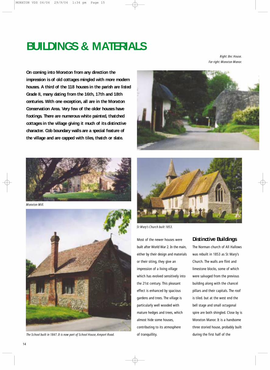
BUILDINGS & MATERIALS
On coming into Monxton from any direction the
impression is of old cottages mingled with more modern
houses. A third of the 118 houses in the parish are listed
Grade II, many dating from the 16th, 17th and 18th
centuries. With one exception, all are in the Monxton
Conservation Area. Very few of the older houses have
footings. There are numerous white painted, thatched
cottages in the village giving it much of its distinctive
character. Cob boundary walls are a special feature of
the village and are capped with tiles, thatch or slate.
The School built in 1847. It is now part of School House, Amport Road.
Monxton Mill.
St Mary’s Church built 1853.
Right: Bec House.
Far right: Monxton Manor.
Most of the newer houses were
built after World War 2. In the main,
either by their design and materials
or their siting, they give an
impression of a living village
which has evolved sensitively into
the 21st century. This pleasant
effect is enhanced by spacious
gardens and trees. The village is
particularly well wooded with
mature hedges and trees, which
almost hide some houses,
contributing to its atmosphere
of tranquillity.
Distinctive BuildingsThe Norman church of All Hallows
was rebuilt in 1853 as St Mary’s
Church. The walls are flint and
limestone blocks, some of which
were salvaged from the previous
building along with the chancel
pillars and their capitals. The roof
is tiled. but at the west end the
bell stage and small octagonal
spire are both shingled. Close by is
Monxton Manor. It is a handsome
three storied house, probably built
during the first half of the
14
MONXTON VDS 04/04 29/9/04 1:34 pm Page 15

Hutchens Cottage, formerly a farmhouse, overlooking the High Street. Both endwalls have flint horizontal panels in brickwork.
18th century near the previous
farmhouse, which was known as
The Court. The Manor was extended
in the 19th century. It is likely that
there have been farm buildings on
the site since medieval times.
On the opposite side of the
road is Bec House, built as the
Rectory in 1796, and home for a
succession of rectors until 1944.
It is an elegant house built in
Flemish Bond, like the Manor.
A courtyard is formed by an
early 19th century coach house
with stables and an earlier central
block with a hipped thatch roof.
The name of the house was
changed in 1959 to link it with
the Abbey of Bec-Hellouin in
Normandy.
Monxton Mill, at the eastern
end of the High Street, ceased to
be a working mill between the
World Wars. For at least 900 years
before then it had been grinding
the local corn. In the mid-1930s
the mill and the miller’s cottage
were sold as an entity.
The internal workings of the
mill were removed and one of the
millstones has been built into
the roadside wall.
Field House.
The Old Farm House is the only three storied thatched house. It has asingle dormer, with tiled apron and eyebrow eaves .
15
MONXTON VDS 04/04 29/9/04 1:34 pm Page 16

BUILDINGS & MATERIALS continued
Corner Cottage, Amport Road. Built 17th century. Raised eyebroweaves over upper windows and lowered over porch.
Little Prospect Farmhouse.
Right: Rectory Cottage, Amport Road. Late 18th century thatched
cob cottage with single storeythatched extension.
Right: Hals Croft, Abbotts Ann Road. Built 17th century with cob over flint base,some exposed frame and eyebrow dormers.
Fourways Cottage, at the crossroads; mid 18thcentury with half hippedroof and cat slide at rear.
Old CottagesThe largest concentration of
thatched cottages is at the centre
of the village. The three at the
crossroads were built in the mid
18th century, but the white painted
cottages along the north side of
the High Street are probably a
century older. 16th and 17th
century cottages tend to be
scattered throughout the village.
Most cottages now comprise
two or three former cottages which
have been renovated, joined
joined
together and extended. Although
the cottages along the High Street
lack a pavement, they have the
benefit of gardens going down to
the bank of the Pillhill Brook.
Many of the older properties
have interesting architectural
features. The majority of the
house walls are constructed either
of cob on flint bases or brick and
flint. A few cottages with slate or
tile roofs are as originally built,
but some have been tiled after fire.
Thatched roofs are usually
made from long straw or combed
wheat reed; they tend to be either
hipped or half hipped, with eaves
raised over upper windows but
lowered over porches, eyebrow
dormers, exposed frames in upper
gables, and cat slides. Unpainted
cottages with walls of flint and
brick are built in a number of
different styles: for instance
horizontal flint panels with
brickwork.
Mellow red bricks have been
used with occasional blue bricks
forming patterns when used with
flint or with only brick.
Restorations andNewer Houses Restorations
Brewery House in Green Lane,
originally The Bush Inn, was built
around 1590. It was partially
destroyed by fire in 1703 and was
rebuilt in 1705. The surviving part
of The Bush Inn now forms about
one third of Brewery House.
During restoration work in
2002, the remains of severely
charred beams were found in the
part of the house which had
been the old Inn. Also discovered
were original brick, flint, cob, and
wattle and daub construction.
Little Cottage, Andover Road. Formerly two 18th century cottages,with eyebrow dormers.
16
MONXTON VDS 04/04 29/9/04 1:34 pm Page 17

In Chalkpit Lane in the year
2000 fire destroyed Garden
Cottage, a dwelling converted
from a stable. A white painted,
thatched house was rebuilt on the
same site in 2002. The main factor
influencing the design of this 21st
century cottage was the close
proximity of the 16th century
cottage, Dingley Dell.
Constructed of modern
materials, Garden Cottage was
designed to be similar in size and
scale to the nearby cottage.
This has resulted in a house of
charm and character enhancing
its location.
Manor Farm dates back as a
barn from around 1875. The sympa-
thetic conversion of two barns to a
farm house was completed in 1992.
The front of the barn has been
rebuilt with local bricks and flint.
Reclaimed slates were used for
the roof. The positioning of windows
remains unaltered and original
beams have been retained. In 1997
the building was judged to be an
outstanding example of converting
redundant farm buildings to a farm
house and received an architectural
award from the Country Land and
Business Association’s (known as
the ‘CLA’) Buildings Award Scheme.
Design GuidelinesTo maintain the distinctive appeal of Monxton,ancient and modern, in its rural location:
• in the cases of new developments, effort shouldbe made to ensure that they do not dominate thelocality and should be blended sympatheticallywith nearby dwellings in respect of scale, materials and design.
• smaller houses are preferred and care should betaken to ensure that low rooflines are achieved.Well proportioned dormer windows can be effective in achieving this.
• extensions should complement the existing buildingusing materials which harmonise with those originally used. Wall heights and fenestrationshould relate closely to the existing dwelling bothin materials and style. Roof extensions should bein the same material as the existing roof.
• if thatch is used, hipped roofs and raised eaves are traditional and should be considered in designs.
• the incorporation of flint in walls should be considered; locally made bricks in mixed mellowtones should be used. Other possibilities to bethought of include white or cream painted rendered walls.
• roofs of thatch or slate are traditional but tilescould be used and should be in mellow tones.
Garden Cottage.
Right: BreweryHouse, formerly
the Bush Inn.
Below: Manor Farm.
17
MONXTON VDS 04/04 29/9/04 1:34 pm Page 18

BUILDINGS & MATERIALS continued
Newer Houses
Cambridge Cottage on Andover
Road is the oldest of the modern
houses in Monxton. It was built by
King’s College in the early 20th
century, less than twenty years
before the College sold its entire
estate in the parish. Seventy-six
houses have been built since then.
Most of the newer houses
were built post 1945. In Broad
Road the new properties are
mainly built on the west side of
the road and range through
bungalows, semi-detached houses
and detached houses, all in a
variety of styles.
Substantial brick houses and
bungalows have been built on one
side of Chalkpit Lane. They are set
back from the road, secluded in
well spaced gardens with mature
trees and boundaries of hedge or
brick. Chalkpit Lane is narrow and
incompatible with large vehicles.
The new dwellings in Green Lane
are mostly sited below road level
apart from two which are raised
on a bank.
Only seven new dwellings
were built in the 1990s and the
beginning of the 21st century.
For the most part, these houses
have been sited so that their scale
and design have allowed them to
blend into their individual locations.
This is of paramount importance
in preserving the character and
personality of the village.
Sunnybank. To the east a
terrace of six retirement bungalows
was built in 1961 when the name
Sunnybank was first used. In 1967
Andover Rural District Council
built eighteen houses for people
from local parishes. They have
varying sized gardens pleasantly
arranged around a close.
The houses all have dormer
windows so do not obtrude on
the countryside. There are four
bungalows, all set well back from
the road.
Prospect. The area is a mile
and a half south of the main
settlement in Broad Road, with
eight houses and several small
businesses. Apart from two early
19th century dwellings all the
houses were built in the later part
of the 20th century. To the right
off Broad Road is a lane with
small businesses, together with
Morrells Farm, a dormer
windowed brick and flint house
with design characteristics
particularly sympathetic to
Monxton in both scale and style.
Prospect Farm is further south on
Broad Road with its contemporary
farm buildings. Those no longer
used for farming purposes house
small businesses associated with
agriculture.
Cambridge Cottage, Andover Road.
Right: Spinney Hill, Broad Lane.
Below Left: Pillhill Lodge built at lowerlevel than the road on Green Lane.
Below Right: Burnside, Chalkpit Lane: roof-line kept
low with dormer windows.
Lower: Retirement bungalows,Sunnyside.
Right: Jevron,Andover Road.
Below: Morrells Farm:house at Prospectbuilt traditionally
with local flint and brick.
18
MONXTON VDS 04/04 29/9/04 1:35 pm Page 19

This aerial photograph demonstrates particularlywell the wooded nature of Monxton.
19
MONXTON VDS 04/04 29/9/04 1:35 pm Page 20