montrose planning commission agenda wednesday, january...
TRANSCRIPT
MONTROSE PLANNING COMMISSION AGENDA Wednesday, January 18, 2017 - 7:00 PM
Montrose Community Center
200 Center Avenue South Montrose, Minnesota 55363
1. Call to Order
2. Roll Call
3. Approval of Agenda
4. Approval of Minutes a. December 21, 2016
5. Public Hearings
6. New Business
a. Introduction of new City Planner – Mark Kaltsas – Terramark b. Election of Vice-Chair
7. Unfinished Business
a. Annual Review Conditional Use Permit/Interim Use Permit Update b. Rental Housing Ordinance Update c. Comprehensive Plan Update
- Parks and Trails - Land Use and Implementation
8. Miscellaneous
a. Next meeting – February 15, 2017
9. Adjournment
1

MONTROSE PLANNING COMMISSION MINUTES December 21, 2016 7:00 PM
Montrose Community Center
200 Center Avenue South Montrose, MN 55363
1. CALL TO ORDER
a. Roll Call
Pursuant to call and notice, the Montrose Planning and Zoning Commission met in regular session on Wednesday, December 21, 2016. Those present were Chair Cory DeWitte, Commissioners Sylvia Henry, Chuck Smallwood, Catherine Neiberger, Kurt Andersen, and Tracy Gurneau. Also present were Council Liaison Lloyd Johnson, City Clerk/Treasurer Margaret McCallum and City Planner, Jo Foust. Absent: None. The meeting was called to order at 7:05 p.m. by DeWitte.
2. APPROVAL OF AGENDA
Commissioner Smallwood moved to approve the agenda. Commissioner Gurneau seconded. Motion passed 6-0.
3. APPROVAL OF MINUTES
a. November 16, 2016 Planning Commission Minutes
Commissioner Henry moved to approve the November 16, 2016 minutes. Commissioner Smallwood seconded. Motion passed 6-0.
4. PUBLIC HEARINGS
a. Zoning Ordinance Amendment – Institutional District, Parks as a Permitted Use.
The meeting was closed and the public hearing was opened at 7:06 p.m.
2
Foust informed that the Planning Commission was asked to conduct a public hearing to amend Section 1082-2 of the Zoning Ordinance, Permitted Uses in the Institutional District, to include E. Parks, playgrounds and athletic fields. She said that currently within the Institutional District, parks, playgrounds and athletic fields are allowed as an accessory use to a permitted use. She stated that they are also allowed as a Conditional Use (following a public hearing), provided conditions are met. Foust highlighted the following permitted principal uses within the Institutional District that require no public hearing:
A. Governmental or public related utilities, buildings or structures necessary for the health, safety, and general welfare of the City.
B. Pre-school, elementary, junior or senior high schools having a regular course of study accredited by the State of Minnesota.
C. Publicly owned civic or cultural buildings, such as libraries, city offices, auditoriums, public administration buildings or historical developments.
D. Religious institutions, such as churches, chapels, temples and synagogues. She said that parks, playgrounds and athletic fields do not appear to be ant more intense of a use than that current permitted uses in the Institutional District. Foust states that within the R-1, R-2, R-3, R-4, and R-B Districts, “Public parks, playgrounds, recreational uses and directly related buildings and structures.” Are permitted uses. Foust said that the Regional Park within the Rolling Meadows Greenway Corridor is within the Institutional District and that staff is recommending that the Zoning Ordinance be amended to allow parks, playgrounds, and athletic fields as a permitted use in institutional districts, similar to the residential districts. The meeting was opened and the public hearing was closed at 7:09 p.m. Gurneau moved to approve and recommend to Council the amendment to Section 1082-2.E. to include Parks, Playgrounds and Athletic Fields. Henry Seconded. Motion passed 6-0.
b. Zoning Ordinance Amendment – Institutional District, Temporary Storage Units as an Accessory Use.
The regular meeting was closed and the public hearing was opened at 7:11 p.m.
Foust informed that the Planning Commission is being asked to conduct a public hearing to accept input on an amendment to Section 1002: Definitions, to include a definition for “Temporary Storage Unit”’ and an amendment to Section 1082-3, Permitted Accessory Uses in the Institutional District, to allow Temporary Storage Units as an accessory use, provided conditions are met.
She stated that Chapter 1002, Definitions currently defines “Temporary Structure” as a structure not permanently erected on a site with a foundation that is used for emergency purposes or
3
used on a construction site for offices and equipment storage during construction of a permanent structure.
Foust said that there has been a request that Temporary Storage Units be allows as a permitted long-term use in the Institutional District. She stated that it is important to differentiate between the Temporary Structure and Temporary Storage Unit, as one may be used as a temporary principal use and other only as an accessory use.
She proposed the following definition:
“Temporary Storage Units”: are transportable units designed and used primarily for storage of building materials and/or equipment. Temporary Storage Units may be used as long-term accessory structures in the Institutional District; provided the conditions in Section1082-3 are met.
Foust said that the Planning Commission is also being asked to accept input on an amendment to Chapter 1082, Institutional District, Section 1082-3, Permitted Accessory Uses, to include the following as an allowable use:
H. Temporary Storage Units as a permanent accessory structure to an institutional use provided:
1. The storage unit be located in a required or side or rear yard setback, where it is not visible from adjacent roadways or properties;
2. The storage unit be placed on an impervious surface or Class 5 gravel, as approved by the City Engineer, to control weeds;
3. The exterior of the storage unit is similar in material and color to the principal structure, in accordance with Section1018-5; and
4. Water and sewer utilities should not be extended to the structure. Electric service may be extended to the structure in accordance with the Minnesota State Electric Code.
The public hearing was closed and the regular meeting opened at 7:13 p.m.
DeWitte moved to approve the amendments to Section 1002: Definitions and Section1082-3 Permitted Accessory Uses in the Institutional District. Henry seconded. Motion passed 6-0.
5. NEW BUSINESS a. Rental Housing Ordinance McCallum informed that the Planning Commission was to receive information and have a discussion on a potential Rental Housing Ordinance for the City of Montrose. She said that the purpose of a Rental Housing Ordinance would be to provide minimum standards to safeguard the health and the public welfare of the residents of rental properties by regulating and controlling the use, occupancy, maintenance and repair of rental buildings and structures.
4
McCallum said additionally registration of rental units would assist the City in identifying where rental units exist, inspection of the units would compel landlords to correct violations and properly maintain rental properties within the City, and it would ensure that rental housing is safe and sanitary and is operated and maintained as to not become a nuisance to the neighborhood or create a disincentive to reinvest in the community. McCallum provided an example ordinance from the City of Hanover. She stated that if the City is interested in drafting such ordinance, that staff would have to further determine which items would be inspected, the cost of implementation, and the frequency of inspections. She said that the City’s current building inspector, MetroWest Inspections, would perform the inspections. McCallum recommended that if an ordinance is written that registration and inspection fees be established to cover the cost of administering the ordinance. She informed that at the November 14, 2016 meeting, the City Council directed staff to send this item to the Planning Commission for discussion and review. Neiberger asked who brought this to the Council’s attention as a suggestion. Smallwood said that he did. Neiberger said that a Rental Ordinance is a complex issue and that it would be “opening up a can of worms”. DeWitte stated that he thought it would be a good idea to draft something because at this time the City cannot do any enforcement of rental properties that are being managed poorly. He said that it would be irresponsible for the City to continue to allow for rental homes that are out of compliance and that landlords need to be held accountable. Foust explained that ordinances vary between communities in what is inspected, regulated and registered. She said that it is a life-safety issue. She said it allows the City to know where units are in town and the ability to inspect and implement safety controls. Neiberger asked how the City would know all the rental properties in town. Foust said that the City would ask for registration of rental properties, nonetheless, that not everyone will comply with the registration process. She stated that the City can only do its best to locate as many as possible. Gurneau asked is fines would be issued to those properties that fail the inspection and if they have a certain amount of time to comply. Foust stated yes. Neiberger said that by writing the ordinance, the City is asking for investors to invade the community.
5
DeWitte said that there are investors already in the community, citing specifically Renters Warehouse. Neiberger informed that there are landlord/tenant statutes and that the City shouldn’t get involved in that. Gurneau asked what the next step in the process would be. Foust recommended getting sample ordinances from additional cities to review and pull information from to create the City’s own ordinance. Neiberger said that the ordinance would likely not get executed properly. Henry said she would like to see additional information presented to the Commission. DeWitte moved to direct staff to gather additional information on the Rental Housing Ordinance and bring it back to the Commission for review. Gurneau seconded. Motion passed 6-0. b. Annual Review of CUPs & IUPs Foust informed that on an annual basis, the Planning Commission reviews properties with Conditional Use Permits and Interim Use Permits to verify compliance with conditions. She listed the properties that will be inspected over the next month. She said that if items are found to be out of compliance, that staff will contact the property owners and/or businesses and identify a plan to bring the site into compliance. She asked that the Commission considered extending this to the January meeting as there is a change is staff. DeWitte moved to table the item of Annual Review of CUPs and IUPs to January’s meeting. Henry Seconded. Motion passed 6-0. c. 2016 Annual Report of Planning Commission Activities Foust reviewed a written report of the Planning Commission’s activities for 2016. She said that it is useful to review and track trends in building construction, issuances of variances, Conditional Use Permits, Interim Use Permits, and Zoning Ordinance Text Amendments. Jo thanked the Commission for serving. Gurneau moved to recommend that the annual report be forwarded to the City Council for review. Henry Seconded. Motion passed 6-0.
6. UNFINISHED BUSINESS a. Comprehensive Plan Update – Transportation and Utilities Foust reviewed the Transportation and Utilities Section of the Comprehensive Plan.
6
6. MISCELLANEOUS a. Semi-Truck Parking
McCallum informed that the Council recommended that the Planning Commission discuss allowing Semi-tractors and trailers to park in residential districts. She said that there is a resident asking for a possible code amendment to allow such. The consensus of the Commission was not to allow parking of semi-tractors/trailers in residential districts.
b. Commissioner Terms
McCallum said that this item would be addressed at the January meeting.
c. Next Meeting – January 18, 2017 at 7:00 p.m. Chair, Cory DeWitte, informed that he would be resigning as Chair of the Planning Commission starting in 2017. He said that he has been on the Commission for 12 years and that is has been a pleasure to serve. DeWitte stated that the Commission has done a lot of good things over the years for the betterment of the community. McCallum thanked Cory for his service on the Commission.
7. ADJOURNMENT
Henry moved to adjourn the meeting at 8:30 p.m. Smallwood Seconded. Motion passed 6-0. Prepared By: Margaret McCallum, City Clerk/Treasurer _____________________________________ Margaret McCallum City Clerk/Treasurer ______________________________________ Cory DeWitte Commission Chair
7
MEMORANDUM
Equal Opportunity Provider and Employer DATE: January 11, 2017 TO: Planning and Zoning Commission FROM: Maggie McCallum SUBJECT: City Planner ACTION TO BE CONSIDERED: To introduce Mark Kaltsas (Terramark) as the new City Planner for the City of Montrose. FACTS:
• On October 17, 2016, the current City Planner and EDA staff liaison, JoAnn Foust, with Municipal Development Group, informed staff and Council that she will be leaving her position with the City as she has accepted a new position.
• At the January 4, 2017 City Council Workshop, the Council interviewed three companies for the City Planner position.
• At the January 9, 2017 City Council meeting, the Council voted to hire Mark Kaltsas as the City Planner for the City of Montrose.
• Mark also works for Terramark, a small landscape architecture/land planning firm.
• He has been doing this work for over 20 years. • He works for other municipalities in the west metro including Watertown,
Maple Plain and Independence.
8
Minneapolis • www.terra-mark.com • Chicago
December 7, 2016 Maggie McCallum, City Clerk/Treasurer City of Montrose 311 Buffalo Avenue South Montrose, MN 55363 Re: Proposal to Provide Planning Services for the City of Montrose Dear Maggie: I appreciate the opportunity to present my proposal for professional planning services to the City of Montrose. I hope that you find my services, experience and qualifications complete and well-matched to the City’s expectations for general consulting planning services. I currently provide similar services to the nearby cities of Independence, Watertown and Maple Plain. Terramark is a planning and landscape architecture firm located in Hennepin County, MN. Terramark focuses on providing the highest level of planning and landscape architectural services to an exceptional list of clients. Terramark is currently working on a broad spectrum of projects, both locally and nationally. Terramark strives to provide the highest level of services for an equitable fee. I believe that our ratio of service and experience to cost offers a value to our clients unmatched by other planning consulting firms. It is understood that the City of Montrose would like to retain a firm to provide general consulting planning services in all areas of planning, zoning and development. In addition, the City would like the planner to attend monthly Planning Commission and City Council Meetings as requested. I have considerable experience working in all areas of planning, zoning and development. I believe that my experience, excellent work record, and current work load would allow me to provide a full array of services responding to all of the responsibilities identified by the City. I currently have the time and resources to offer both on-site and off-site service to the city. With respect to services, Terramark’s hourly rates are as follows:
Compensation to Terramark for services provided shall be on an Hourly Rate basis. Professional services provided to the city for general work items will be billed at the hourly rate of $74.00/hour. Charges will be made based on a minimum increment of 1/25 hour. Professional services provided to the city for development review or similar “pass through” work items will be billed at the hourly rate of $85.00/hour. Charges will be made based on a minimum increment of 1/25 hour.
Attendance at City Council, Planning Commission and any other requested evening meetings will be billed $74.00 for the first two (2) hours and then billed hourly for any additional hours. Administrative services will be billed at an hourly rate of $50.00 per hour. Mileage for regularly scheduled meetings, office hours and events and typical reimbursable office expenses will not be billed.
9
Terramark Proposal – City of Montrose, MN December 7, 2016
Should you have any questions or comments regarding this proposal please feel free to contact me. Sincerely, Terramark
Mark L. Kaltsas, PLA President
10
AN ORDINANCE OF THE CITY OF MONTROSE REGARDING RESIDENTIAL RENTAL PROPERTY REGISTRATION AND INSPECTION
BE IT ORDAINED BY THE CITY COUNCIL OF THE CITY OF MONTROSE, MINNESOTA, THAT:
Chapter ____ of the City Code be amended to include the following:
____ RESIDENTIAL RENTAL PROPERTY REGISTRATION AND INSPECTION
Subd. 1 Purpose. The purpose of this Section is to protect the public health, safety and community at large, and the residents of rental properties in the City. The purpose is also to ensure rental housing is safe and sanitary, and operated and maintained so it not become a nuisance of a disincentive to invest in the community.
The operation of residential rental property is a business enterprise which entails certain responsibilities. Owners are operators and are responsible for taking reasonable steps to ensure that the residents who occupy rental properties may pursue the quiet enjoyment of the normal activities of like in their surrounding area that are safe, secure, and sanitary.
Subd. 2. Definitions. For the purposes of this Section, the following definitions shall apply unless the context clearly indicates or requires a different meaning.
Rental Manager. Any person who has been delegated by the residential property owner in charge, care or control of a residential rental property, and is able to respond in person to issues related to the residential rental property.
Residential Rental Property. Any building, or one or more portions thereof , occupied or intended to be occupied for residential purposes by a residential tenant.
Residential Rental Property Owner. Any person or entity owning residential rental property within the City.
Residential Tenant. A person who does not own, but occupies a dwelling for residential purposes, for payment or a fee or other compensation to the owner, under a lease or contract, whether written or verbal.
Subd. 3. Applicability and Scope.
11
1. This Section applies to any dwelling, and any dwelling unit therein, that is a residential rental property, including garages, storage buildings and appurtenances. This Section does not apply to Minnesota Department of Health – licensed rest homes, convalescent care facilities, group homes and nursing homes, hotels, motels, and owner-occupied units.
2. Properties not existing as Rental Property at the time of adoption of this article and afterward becoming Rental Property shall, before being certified, comply with all the provisions of the Section. Properties pre-existing at the adoption of this article shall be allowed a reasonable time to comply. Reasonable time being defined on a case-by-case basis subject to the discretion of the Code official.
Subd. 4. Rental Manager Required. All residential rental properties shall be registered with the city by either the residential property owner or rental manager.
Subd. 5. Registration Requirements.
A. Registration of each residential rental property shall be made on a separate form provided by the City and shall include the following information: 1. The name, address and telephone number of the residential rental property owner
and rental manager. 2. The name, address and telephone number of the person completing the registration
form. 3. The address of the residential rental property. In the case of an apartment building,
the applicant shall provide the address and name for the building as well as the number of dwelling units contained therein.
4. Verification that the residential rental property owner and rental manager conducts a criminal background check on each and every residential tenant.
5. Verification that a written lease exists for the residential rental property owners and each unit dwelling thereon; and
6. Verification that a written lease addendum commonly known as “Drug Free/Crime Free Lease Addendum” exists for each and every written lease entered into after the effective date of this Section.
7. The maximum number of occupants for each dwelling unit or sleeping room. 8. The number of off-street parking spaces provided for each unit.
12
9. The name, phone number or address of the local person authorized to make or order made repairs or services for the property, if in violation of City or State codes, if the person is different than the owner or local designated agent.
B. Upon receipt of a fully completed registration form, the city shall issue to the registrant a certificate of registration as proof of registration. Certificates of registration shall be non-transferable and state the following:
1. The date of issuance. 2. The address of the residential property and the name, if an apartment building, of
the residential rental property owner. 3. The names of the renal managers. 4. The number of dwelling units located within the residential rental property.
Within 30 days of transfer of ownership, change of rental manager, change in the number of rental units, or change in dwelling occupancy, the residential property owner or rental manager shall complete and submit a registration form for each and every residential rental property affected by the transfer or change.
C. A residential rental property owner owning residential property at the time of this adoption shall have 180 days after its effective date to comply with the registration provisions contained therein.
D. Each certification issued pursuant to this Chapter shall expire on December 31 in the third year. The City shall be required to mail renewal registration statements to the property owner or the designated agent on or before October 1 every third year. Failure to receive a renewal registration statement from the City shall not excuse the owner from meeting the registration and certification requirements. Renewal registration statement may be returned by mail, at the property owner’s risk, to City Hall.
E. All records, files and documents pertaining to the Rental Registration and Rental Unit Inspection Program shall be maintained in the office of the City Clerk/Treasurer and made available to the public as allowed or required by State law and provisions of the City Code.
Subd. 6. Registration Fee. There shall be a per unit registration and inspection fee, every three years. The fee shall be set forth by resolution of the Council in the annual fee schedule of the City. The registration fee shall be paid at the time the registration form is submitted to the City.
13

Subd. 7. Minnesota Crime Free Multi-Housing Program
A. The City has established a rental owner educational program consistent with the Minnesota Crime Free Multi-Housing Program. The educational program includes information such as: applicant screening, rental agreements, identification of illegal activity, eviction process, the roles of working with the police, crime prevention, code enforcement and public health, licensing and inspections, and active property management. All residential property owners and rental managers must attend phase one of the Crime Free Multi-Housing Program within one year after the issuance of a certificate of registration. Either the property owner or manager must hold a phase one certification at all times. Phase one training will be conducted on a regular basis. Program attendees will be required to pay a participation fee in an amount determined to cover the direct cost of the program.
B. The city will recognize proof of phase one certifications from other entities.
C. An owner or property manager operating a single family home or property with three or fewer units need only complete phase one of the Crime Free Multi-Housing Program. Owners or property managers with four or more units are requires to complete all three phases of the Crime Free Multi-Housing Program.
D. A residential rental property owner whose only rental dwelling is a single-family dwelling homesteaded by a relative Is exempted from the program.
E. All residential property leases entered into after the effective date of this Section shall contain the written lease addendum commonly known as the “Crime Free/Drug Free Lease Addendum.”
Subd. 8 . Responsibility of Owners. The owner of a dwelling or dwelling unit shall be responsible for the maintenance of the structure and for meeting the provision of this article. Those responsibilities may not be abrogated by a private agreement.
Subd. 9. Space and Occupancy Requirements. No rental dwelling unit shall be let for occupancy to another, which does not comply with the following requirements:
1. Room dimensions: a. Ceiling heights shall be no less than seven (7) feet measured to the lower projection
from the ceiling.
14

b. Floor area. Dwelling units and congregate residences shall have at least one room for common living that have at least 120 square feet of living area. Rooms used for sleeping purposed by one person shall have an area of not less than 70 square feet and an additional 50 square feet for each additional occupant.
c. Width. No habitable room other than a kitchen shall be less seven feet in any dimension.
d. Units shall also be inspected for lighting, ventilation, mechanical, electrical and plumbing, egress, structure requirements and life/safety requirements (smoke detectors, fire extinguisher, fire sprinkler and fire alarm system and carbon monoxide detectors) applicable to state building and housing codes.
2. Kitchen. Every dwelling unit shall have a room or portion of a room in which food may be prepared and/or cooked which shall have adequate circulation area and shall be equipped with a functional kitchen sink and stove and refrigerator.
Subd. 10. Exterior Building Requirements. Each unit shall have access to its entry via a sidewalk or driveway. Decks and stairways shall meet Minnesota Building Code, with appropriate handrails and/or guard rails.
Subd. 11. Joint Responsibilities of occupants and Owners.
1. No owner, operator or occupant of any rental units shall allow the accumulation or formation of dirt, filth, refuse or rodent harborages on the premises which is occupied or controlled in a manner that could create a health hazard to the dwelling occupants or general public.
2. Nuisances: No owner, operator or occupant of any rental unit shall allow the formation of presence of any nuisances in or about the premises he/she occupies or controls.
Subd. 12. Certification suspension and revocation.
1. Any certificate may be revoked or suspended at any time during the life of said certification for grounds including , but not limited to the following: a. False or misleading information given or provided in connection with the registration
statement or renewal;
15

b. Failure to pay any fee herein provided for; c. Failure to permit any officer or employee of the City charged with the duty of
making inspections or enforcing any provisions of the Code, access to the premises at a reasonable hour to determine whether the facilities conform with the provision of the article;
d. Violation by the certified owner or anyone operating there under, or any provision of this Code or laws of the State relating, pertaining to, or governing the certificate and premises;
e. Maintaining, permitting, or allowing residential rental property to be used for a disorderly house, unlawful assembly or public nuisance.
2. A suspended certificate shall be reinstated when the circumstances leading to the
suspension have been remedied and a reinstatement and inspection fee as set by Council resolution has been paid. After a certificate has been revoked, a new certificate may be issued only if the circumstances leading to the revocation have been remedied, a new registration is made, and an addition reinstatement and inspection fee as set forth in Council resolution has been paid.
Subd. 13. Enforcement. In order to compel compliance with the registration requirements, the Building Official or their designee shall authority to enter any building, at a reasonable time and upon five days’ written notice to the tenant, to determine if said building is operated as a rental property, or to enforce the Uniform Housing code, or both.
Subd. 14. Violation.
1. It is a misdemeanor for any person to provide false information on the prescribed registration form.
2. It is a misdemeanor for any person or entity to operate or cause to be operated any property as a residential rental property without first registering with the City as set forth in this Section.
3. It is a misdemeanor for any residential rental property owner or rental manager to rent residential property without first conducting a background check and entering into a written lease that contains the written lease addendum commonly known as the “Drug Free/Crime Free Lease Addendum.”
Subd. 15. Authority. Nothing in this article shall prevent the city form taking action under any of its City fire, housing, zoning or other health safety codes for violations thereof to seek either injunctive relief or criminal prosecution for such violations in accordance with the terms and
16
conditions of the particular provisions of this City Code under which the City would proceed against the property owner, designated agent or occupant of any residential rental dwelling unit covered by this article.
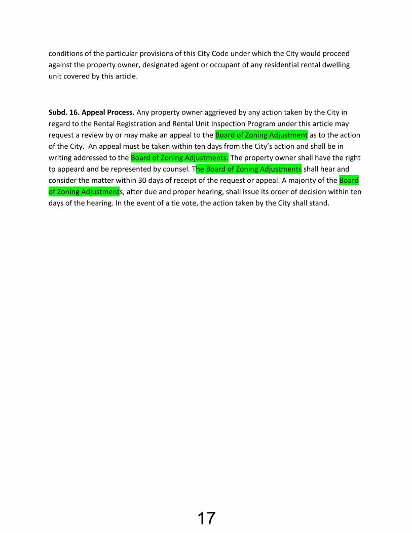
Subd. 16. Appeal Process. Any property owner aggrieved by any action taken by the City in regard to the Rental Registration and Rental Unit Inspection Program under this article may request a review by or may make an appeal to the Board of Zoning Adjustment as to the action of the City. An appeal must be taken within ten days from the City’s action and shall be in writing addressed to the Board of Zoning Adjustments. The property owner shall have the right to appeard and be represented by counsel. The Board of Zoning Adjustments shall hear and consider the matter within 30 days of receipt of the request or appeal. A majority of the Board of Zoning Adjustments, after due and proper hearing, shall issue its order of decision within ten days of the hearing. In the event of a tie vote, the action taken by the City shall stand.
17

18
19
2015P k dT il Pl20
Parks, Trails and Recreation
I. Introduction Parks, trails and recreational facilities are valuable community resources that contribute positively to the quality of life in a community. Parks and trails have a positive impact on a city’s environmental and economic value as well as its residents’ physical and social health. Parks with trees and shrubs and open space help reduce the carbon footprint in communities. Studies have shown the market values of homes adjacent to parks are higher than those greater distances from parks. Parks and trails provide greater opportunities for residents to participate in physical activities increasing the overall health of a community and finally, parks provide gather spaces for social interaction and locations for community events. This Chapter will provide an overview of:
1. Demographics Served 2. Park Classifications 3. An Inventory Existing Park Facilities 4. Existing and Future Park Facility Needs 5. Recreational Facility Standards 6. Existing Trails and Pedestrian Ways 7. Proposed Future Trails and Pedestrian Ways 8. Community Input; 9. Administration, Maintenance and Operations 10. Recommended Goals and Policies for Future Parks, Trails and Recreation Facilities and
Programs. The following maps are included:
6-1 City Parks and School Recreational Facilities 6-2 Park Service Areas 6-3 Park Search Areas 6-4 Existing Sidewalks and Trails 6-5 Trail and Sidewalk Plan 6-6 Park Search Areas and Trail/Sidewalk Plan
A majority of the content within this Chapter was derived from the December, 2015 Montrose Master Parks and Trail Plan, developed by the Parks Commission and city staff.
II. INTENT It is a goal of this Comprehensive Plan to provide parks, trails and recreational opportunities for residents of all ages and incomes, now and in the future. Providing quality recreational opportunities begins with proper planning. To assure adequacy and maximum usability, recreational areas and facilities shall be developed with regard for the needs of the people and the area they serve. Proper planning must take into consideration a number of factors, including
20

2015P k dT il Pl21
but not limited to, location of existing recreational areas (i.e. proximity to the area served, separation from incompatible land uses), adequacy of existing facilities, site planning for the location of future facilities, access to current and future facilities, provisions for recreation programs, and financing, maintenance and management of existing and proposed parks, trails and recreational facilities.
III. DEMOGRAPHICS SERVED In order to plan for existing and future parks, trails and recreational programming, it is important to understand the market we served in the past, the market we now serve and the market we anticipate serving in the future. Population Changes The City of Montrose grew 8% between 2010 and 2015, from 2,847 to 3,079. This plan is intended to guide growth to the year 2040, with a projected population of 6,055. As a result, the Parks, Trails and Recreational Chapter includes an analysis of current facilities and programs as well as facilities which may be needed to serve an additional 2,976residents. Age of residents/market The median age of Montrose residents was 29.5 years in the year 2010. The Minnesota State Demographer’s Office projects the largest increases in population over the next 20 years will be in the 60+ year segment of the population, therefore increasing the median age over time. This Chapter recognizes the importance of planning park facilities and recreational programs for all age groups. Income of our residents/market The 2010-2-14 ASC reports a Median Family Income in Montrose of $66,270 and a Median Household Income of $62,419. This compares to a Wright County Median Household Income of $73,085 and median Family Income of $83,758. This Chapter recognizes the need to provide recreational opportunities for individuals/families of all income levels. Household/family make-up In 2010, 70.4% of all households were “family households”, with 29.6% of households “non-family households”.
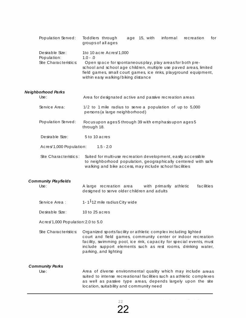
IV. PARK CLASSIFICATIONS
The City of Montrose features a number of existing park and recreational facilities. Recreational facilities within the City can typically be described according to their type, population served and location. The following terms and descriptions shall be used to classify existing and future recreational facilities, as taken from the 2015 Montrose Master Park and Trail Plan. Neighborhood Mini Parks
Use: Designed to provide passive activities with some active short term activities and may include specialized facilities serving a limited population or specific group such as a playground
Service Area: Neighborhood sizes of 1,000 to 5,000 persons, within 1/4 to 1/2 mile
21
2015P k dT il Pl22
Population Served: Toddlers through age 15, with informal recreation for groups of all ages
Desirable Size: 1to 10 acre Acres/1,000 Population: 1.0 - .0 Site Characteristics: Open space for spontaneous play, play areas for both pre-
school and school age children, multiple use paved areas, limited field games, small court games, ice rinks, playground equipment, within easy walking/biking distance
Neighborhood Parks
Use: Area for designated active and passive recreation areas Service Area: 1/2 to 1 mile radius to serve a population of up to 5,000
persons (a large neighborhood)
Population Served: Focus upon ages 5 through 39 with emphasis upon ages 5 through 18.
Desirable Size: 5 to 10 acres
Acres/1,000 Population: 1.5 - 2.0
Site Characteristics : Suited for multi-use recreation development, easily accessible
to neighborhood population, geographically centered with safe walking and bike access, may include school facilities
Community Playfields Use: A large recreation area with primarily athletic facilities
designed to serve older children and adults
Service Area : 1- 1112 mile radius City wide Desirable Size: 10 to 25 acres Acres/1,000 Population: 2.0 to 5.0 Site Characteristics: Organized sports facility or athletic complex including lighted court and field games, community center or indoor recreation
facility, swimming pool, ice rink, capacity for special events, must include support elements such as rest rooms, drinking water, parking, and lighting
Community Parks
Use: Area of diverse environmental quality which may include areas suited to intense recreational facilities such as athletic complexes as well as passive type areas, depends largely upon the site location, suitability and community need
22

2015P k dT il Pl23
Service Area: Several neighborhoods, 1to 4 mile radius Population Served: All ages, toddler to retiree, entire community for cities up to 25,000 Desirable Size: 20 to 35+ acres Acres/1,000 Population: 5.0 - 10.0 Site Characteristics: Provides for a combination of intensive and non-intensive development ranging from play equipment to trails, may include
natural features, such as water bodies or forested land, must include support elements such as rest rooms, drinking water, parking, and lighting
Natural/Conservancy Areas Use: Protection and management of the natural/cultural
environment with recreational use as a secondary objective Service Area: No applicable standard, scattered among City parks of all sizes Desirable Size: Sufficient to protect the resource and accommodate desired recreational uses Acres/1,000 population: Variable Site Characteristics: Variable, depending upon the resource being protected
Private Facilities Use: Areas for specialized or single purpose recreational activities, such
as golf courses, nature centers, display gardens, arenas, outdoor theaters, gun ranges, historical buildings/ areas, and parkways or boulevards within commercial centers.
School Facilities
Use: Facilities developed in association with schools which are intended for children's educational and recreational instruction, which on a secondary basis, provide opportunities for community residents, this shared usage is positive in that it allows for daytime usage by students, evening, weekend, and summer usage by all.
23
City of Montrose Comprehensive Plan, 2017 Chapter 6 Page 24
Linear Park/ Trails Use: Area developed for one or more varying modes of recreational
travel, may include other activities such as sitting areas, exercise courses, play areas, landscaping, etc.
Service Area: Not applicable standards Population Served: All of community Desirable Size: Sufficient width to provide for specified activities, maximum
usage, and setbacks from streets or residential areas. Acres/1,000 Population: Variable Site Characteristics: Built or natural corridors such as utility rights-of-way, bluff
lines, vegetation patterns, and roads that link other components of the recreation system or community facilities such as parks, schools, and residential areas.
V. EXISTING PARK AND RECREATION INVENTORY
A. MUNICIPAL PARKS There are thirteen (13) municipal owned parks located within the City of Montrose, providing 111.81 acres of recreational opportunities. In addition, there is a recreational area owned by the school district in the community, and area county and state recreational areas. Following is a summary of existing park and recreational facilities existing in the City of Montrose. Map 6-1 illustrates the locations of these facilities:
1. Carver Field
Size and Location: This 3.8-acre park is the largest park in Montrose. Classification: Neighborhood Park Recreational Amenities: Ballfield Future Improvements: Future improvements to the park recommended include enhancements to the field and an upgraded concession stand.
2. Forest Creek Park
Size and Location: This 7.84-acre park is located south of Breckenridge Lane and east of Cole Avenue, in the northern portion of the City. Classification: Neighborhood Park Park Amenities: Trails
24
City of Montrose Comprehensive Plan, 2017 Chapter 6 Page 25
Future Improvements: This park is located south of Breckenridge Lane east of Cole Avenue in the northern portion of the City. The park is basically a southwesterly extension of Rolling Meadows Park. The Park Commission vision is to connect the trail segment to the rest of the trail system, and to add playground equipment in the future, as well as make it physically handicap accessible.
3. Lent Park
Size and Location: This 9.97-acre park is located on Garfield Avenue, within Parkview addition. Classification: Neighborhood Park Amenities: Skate park. The park and has been graded for a future soccer field; however due to lack of adequate parking, the soccer field(s) cannot be utilized
Future Improvements: If a design is feasible for future parking, future soccer fields
could be added.
4. Lions Park
Size and Location: This 1.0-acre park is adjacent to the City’s watertower. Classification: Neighborhood Park (size, but used as a community park)
Amenities: Swing set, picnic shelter, horseshoe pit, merry-go-round and dirt digger. Future Improvements: The Park Commission recommends replacement or removal of playground equipment.
5. Northridge Park A and Northridge B Size and Location: This 14.6-acre park is located in the southern portion of Northridge subdivision. Classification: Neighborhood Park Amenities: Play structure, volleyball courts, swings, picnic bench, community garden plots, parking lot and trees. Future Improvements: The Park Commission feels there is room in the park for improvements, but recommends the development of the Regional Park be the priority.
6. Hill Street – Parkview Park A & B Size and Location: Parkview Park A is 1.1 acres (upland) and Parkview B is 1.1 acres. This is in Parkview Addition.
25
City of Montrose Comprehensive Plan, 2017 Chapter 6 Page 26
Classification: Neighborhood Park Amenities: None Future Improvements: The Park Commission has not identified plans for future improvements in this park.
7. Pheasant Hills Park
Size and Location: This 7.9-acre park is located within Pheasant Hills Addition. Approximately 2.8 acres is upland with the remainder of the park in wetlands and significant vegetation. Classification: Neighborhood Park/Specialized Recreation Area Amenities: Trail system, play equipment and benches. The park is lit with solar lighting. Future improvements: The Park Commission has not identified plans for future improvements in this park.
8. Preserve of Montrose Park
Size and Location: This 14.3-acre future park is located on the southwest side of the city, south of US Highway 12. Classification: Future Neighborhood Park or Community Park. Amenities: This park is undeveloped at this time. Future improvements: When the Preserve of Montrose is re-platted or redeveloped, the developer will be responsible for the dedication of the park land and possible park improvements.
9. Rock Brook Park
Size and Location: This 0.4-acre park is located north of 7th Street South and west of Brook Circle East. Classification: Neighborhood Park/Pocket Park Amenities: Play structure, climbing rock, picnic table and bench. Future improvements: The Park Commission has not identified plans for future improvements in this park.
10. Regional Park – formerly known as Rolling Meadows Park
26

City of Montrose Comprehensive Plan, 2017 Chapter 6 Page 27
Size and Location: This 26.7-acre park is located on the west side of CR 12, on the north side of the City. Classification: The park will be a community wide park, once developed. Amenities: The park was platted in 2016. Some grading has been completed with additional grading improvements in 2017 planned. Future improvements: A master park plan has been developed for the Regional Park. It is proposed to include a trail system, parking, soccer fields, tennis courts, basketball courts, ice skating rinks, baseball fields and a concession stand as well as playground equipment and restrooms.
11. Thorson Park
Size and Location: This 3.5-acre park is located in Parkside Meadows Addition. Classification: Neighborhood Park Amenities: Play structure Future Improvements: Possibly expand and connect to Lent Park, if land becomes available.
12. Veteran’s Memorial Park
Size and Location: This 3.3-acre park is located north of First Street North and west of CR 12. Classification: Community Park Amenities: Shelter with picnic tables, lighted tennis court, tot lot, swings and basketball court. Future Improvements: Continue to upgrade/maintain amenities.
13. White Tail Ridge Park – Disc Golf Course
Size and Location: This 16.3-acre park is located in the northwest corner of the City. Classification: Specialized Recreation Area. Amenities: Disc Gold Course, dense wooded areas, wetland features and natural rolling topography. Future Improvements: The Park Commission recommends the development of off-street parking.
27

City of Montrose Comprehensive Plan, 2017 Chapter 6 Page 28
B. School Recreational Facilities Montrose Elementary School Facilities - In addition to the City owned parks there is playground equipment at the Montrose Elementary School. While this is not a “municipal park”, the amenities are available to serve the public at times in which school or extracurricular activities are not underway. It is important to note that the Elementary School includes Montrose as well as the surrounding townships.
C. County and State Parks Crow Springs County Park is located south of 40th Street and west of Highway 25 (within Franklin Township). It is operated by Wright County. Public boat access is available within the park, to the Crow River. Two wildlife management areas are operated by the State of Minnesota. The Malardi Lake State Wildlife Area is located east of the City limits south of 45th Street and west of Meridian Avenue. The Woodland State Wildlife Management Area is located south of the City limits, north of 72nd Street and east of Highway 25. Also, the Fountain Lake public access serves as an additional recreational amenity to the area. These facilities provide passive recreational opportunities and environments
28

City of Montrose Comprehensive Plan, 2017 Chapter 6 Page 29
Table 6-1 Montrose Park & Recreational Inventory
Montrose Park Inventory
Acr
es
Trai
l Are
as
Base
ball/
Softb
all
Nat
ure
Are
as
Hors
esho
e Pi
ts
Tenn
is C
ourts
Socc
er F
ield
s
Bask
etba
ll Cou
rts
Foot
ball F
ield
(s)
Vol
leyb
all C
ourts
Play
STR
UCTU
RES
Swim
min
g
Plea
sure
Ska
ting
Rink
Hock
ey R
ink
War
min
g Ho
use
Disc
Gol
f Cou
rse
/ A
rche
ry R
ange
Skat
e Pa
rk
Rest
room
fa
cilit
ies
Hand
icap
A
cces
s
Picn
ic A
rea
Park
ing
(off-
Stre
et)
Carver Field 3.80 x
Forest Creek Park
7.84 X
Lent Park 9.97 X Lions Park 1.00 X X X Northridge Park A & Northridge B
14.60 X
X
X
X
Hill Street- Parkview Park A & B
2.20 X
X
Pheasant Hills Park
7.90 X
X
Preserve of Montrose Park
14.30
Rock Brook Park
0.40 X X
Regional Park (Rolling Meadows Park)
26.70
Thorson Park 3.50 X Veteran’s Memorial Park
3.30 X
X
X
White Tail Ridge Park/Disc Golf
16.30 X
Total 111.18
29
City of Montrose Comprehensive Plan, 2017 Chapter 6 Page 30
VI. EXAMINATION OF EXISTING AND FUTURE PARK FACILITIES
Map 6-2 indicates areas served by existing recreational facilities. As indicated, parks are located to serve the needs of most residential areas of the City, however additional facilities would benefit residents. A. Search Areas. Map 6-3 indicates park search areas. As noted in the park classifications, the service area will vary depending on the type of park. This plan does not identify additional locations for smaller neighborhood parks, rather only those facilities which would serve a greater population and those within a ½ mile radius of the park. Additional neighborhood parks and playgrounds should also be considered as residential neighborhoods develop. The City should closely review the topography, natural resources on sites, access and future roadways, etc. prior to the actual acceptance of dedicated park land to ensure it fits the community’s identified park use needs. B. Accessibility 1The American with Disability Act (ADA) was signed into law on July 26, 1990. The law requires local and state governments, places of public accommodation and commercial facilities to be readily accessible to persons with disabilities. ADA statutes affect the City of Montrose and other local and state park and recreation facilities in the following ways:
Newly constructed buildings (after January 26, 1993) must be constructed to be readily accessible.
Renovations or alterations occurring after January 26, 1992 to existing facilities must be readily accessible.
Barriers to accessibility in existing buildings and facilities must be removed when it is “readily accessible”. This includes the location and accessibility to restrooms, drinking fountains and telephones.
Other requirements include but are not limited to: One accessible route from site access point, such as a parking lot, to the primary
accessible entrance must be provided. A ramp with a slope no greater than 1:6 for a length no greater than two feet may be used as a part of the route. Otherwise a slope with a maximum 1:12 is allowed.
One accessible public entrance must be provided. If restrooms are provided, then one accessible unisex toilet facility must be provided
along an accessible route. Only the publicly used spaces on the level of the accessible entrance must be made
accessible. Any display and written information should be located where it can be seen by a
seated individual and should provide information accessible to the blind. Parks which are developed with items such as parking lots, swimming pools, tennis courts and basketball courts should have routes which are accessible. Nature parks or areas with limited
1 Source: Park, Recreation, Open Space and Greenway Guidelines, James D. Meres, Ph.D., CLP and James R. Hall, CLP. © 1996,
National Recreation and Park Association
30

City of Montrose Comprehensive Plan, 2017 Chapter 6 Page 31
development should have the minimum of accessible routes to the site. The National Park Service provides design guidelines for accessible outdoor recreation. 1 As the City redevelops city parks, it will be important to include ADA standards in the design. Installation of curb cuts and pathways within the park, designation of handicap parking in the parking lots, remodeling of restroom facilities to provide a handicap accessible stall in each of the men’s and women’s facilities and pathways to shelters and recreational amenities has been recommended as a method to achieve accessibility goals.
VII. RECREATIONAL FACILITY STANDARDS
As parkland is acquired either through dedications or purchase, it is important to plan space according to the desired recreational contents. In existing parks, it is important for the City to be aware of space requirements and orientation recommendations to determine if it is feasible to include the item(s) within the park. Following are facility standards for a number of recreational activities:
Unit Land Required
Recommended Size & Dimensions
Recommended Orientation
No. of Units for Population Recommen-ded (National standards)
Service Area Existing Facilities
Local Need Identified
Baseball Diamond
3 to 3.85 acres
1. Official: Baselines-90’ Pitching dist-60.5’ Foul lines-min 320’ Center field-400’+ 2. Little League: Baselines-60’ Pitching Dist.-46’ Foul lines-200’ Center field-200’-250’
Locate home plate so the pitcher is not throwing across the sun, and batter is not facing sun. Line from home plate through pitcher’s mound to run E-NE.
1/6,000 Based on current population- 1 By 2040 need one
Approximately ¼ to ½ mile radius Part of neighborhood complex. Lighted fields part of a community complex
Carver Field
Meets current and future needs per standard. Additional proposed at Regional Park.
Softball/ Youth Diamond
1.5 to 2 acres
Baselines 60’ Pitching dist- 45’ men, women- 40’, Fast pitch field radius from plate – 225’ Slow pitch 275’ men, 250’ women
Locate home plate so the pitcher is not throwing across the sun, & the batter is not facing sun. Line from home plate through pitcher’s mound to run E/NE
1/ 1,500 Based on current population- 5 By 2040 need three
Approximately ¼ to ½ mile radius
31
City of Montrose Comprehensive Plan, 2017 Chapter 6 Page 32
Unit Land Required
Recommended Size & Dimensions
Recommended Orientation
No. of Units for Population Recommended (National standards)
Service Area
Surplus/ Deficit / Standard (Local Standards)
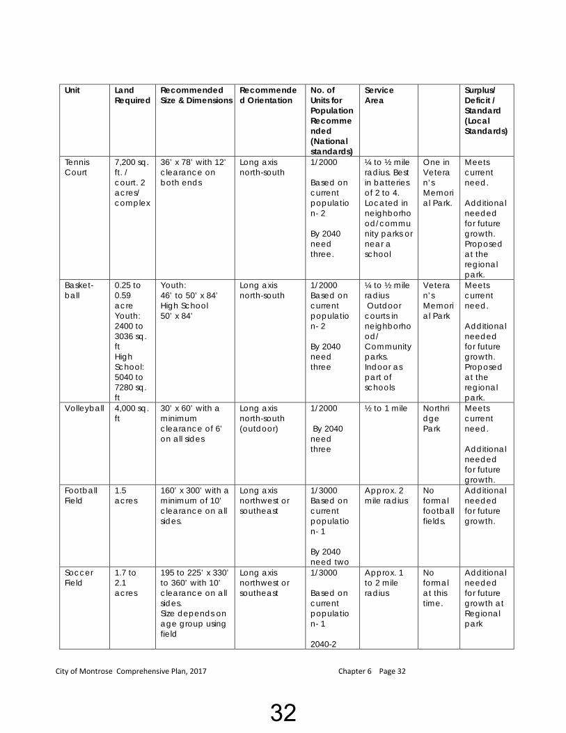
Tennis Court
7,200 sq. ft. / court. 2 acres/ complex
36’ x 78’ with 12’ clearance on both ends
Long axis north-south
1/2000 Based on current population- 2 By 2040 need three.
¼ to ½ mile radius. Best in batteries of 2 to 4. Located in neighborhood/community parks or near a school
One in Veteran’s Memorial Park.
Meets current need. Additional needed for future growth. Proposed at the regional park.
Basket-ball
0.25 to 0.59 acre Youth: 2400 to 3036 sq. ft High School: 5040 to 7280 sq. ft
Youth: 46’ to 50’ x 84’ High School 50’ x 84’
Long axis north-south
1/2000 Based on current population- 2 By 2040 need three
¼ to ½ mile radius Outdoor courts in neighborhood/ Community parks. Indoor as part of schools
Veteran’s Memorial Park
Meets current need. Additional needed for future growth. Proposed at the regional park.
Volleyball 4,000 sq. ft
30’ x 60’ with a minimum clearance of 6’ on all sides
Long axis north-south (outdoor)
1/2000 By 2040 need three
½ to 1 mile Northridge Park
Meets current need. Additional needed for future growth.
Football Field
1.5 acres
160’ x 300’ with a minimum of 10’ clearance on all sides.
Long axis northwest or southeast
1/3000 Based on current population- 1 By 2040 need two
Approx. 2 mile radius
No formal football fields.
Additional needed for future growth.
Soccer Field
1.7 to 2.1 acres
195 to 225’ x 330’ to 360’ with 10’ clearance on all sides. Size depends on age group using field
Long axis northwest or southeast
1/3000 Based on current population- 1 2040-2
Approx. 1 to 2 mile radius
No formal at this time.
Additional needed for future growth at Regional park
32
City of Montrose Comprehensive Plan, 2017 Chapter 6 Page 33
Unit Land Required
Recommended Size & Dimensions
Recommended Orientation
No. of Units For Population Recommended (National standards)
Service Area
Existing Facilities
Surplus/ Deficit / Standard (Local Standards)
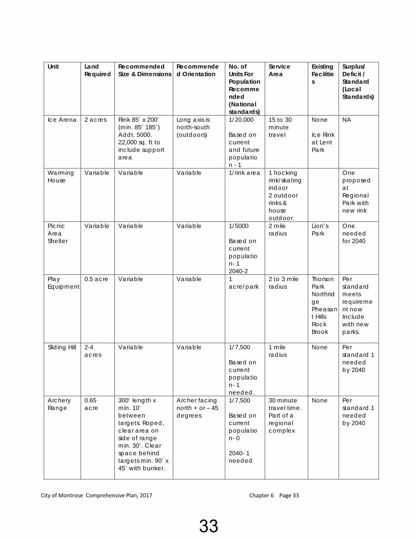
Ice Arena 2 acres Rink 85’ x 200’ (min. 85’ 185’) Addt. 5000. 22,000 sq. ft to include support area
Long axis is north-south (outdoors)
1/20,000 Based on current and future population - 1
15 to 30 minute travel
None Ice Rink at Lent Park
NA
Warming House
Variable Variable Variable 1/rink area 1 hocking rink/skating indoor 2 outdoor rinks & house outdoor.
One proposed at Regional Park with new rink
Picnic Area Shelter
Variable Variable Variable 1/5000 Based on current population- 1 2040-2
2 mile radius
Lion’s Park
One needed for 2040
Play Equipment
0.5 acre Variable Variable 1 acre/park
2 to 3 mile radius
Thorson Park Northridge Pheasant Hills Rock Brook
Per standard meets requirement now Include with new parks.
Sliding Hill 2-4 acres
Variable
Variable 1/7,500 Based on current population- 1 needed.
1 mile radius
None Per standard 1 needed by 2040
Archery Range
0.65 acre
300’ length x min. 10’ between targets. Roped, clear area on side of range min. 30’. Clear space behind targets min. 90’ x 45’ with bunker.
Archer facing north + or – 45 degrees
1/7,500 Based on current population- 0 2040- 1 needed
30 minute travel time. Part of a regional complex
None Per standard 1 needed by 2040
33
City of Montrose Comprehensive Plan, 2017 Chapter 6 Page 34
Unit Land Required
Recommended Size & Dimensions
Recommended Orientation
No. of Units For Population
Service Area Existing Facilities
Surplus/ Deficit / Standard (Local Standards)
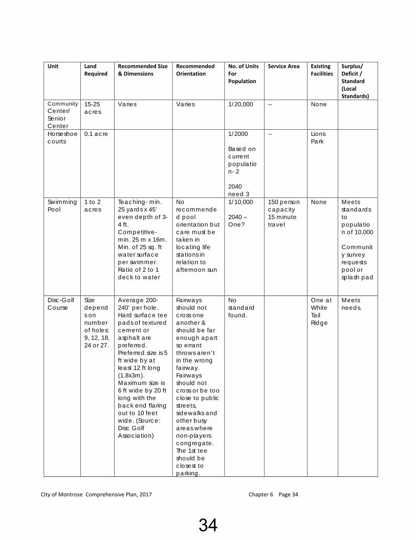
Community Center/ Senior Center
15-25 acres
Varies Varies 1/20,000 -- None
Horseshoe courts
0.1 acre 1/2000 Based on current population- 2 2040 need 3
-- Lions Park
Swimming Pool
1 to 2 acres
Teaching- min. 25 yards x 45’ even depth of 3-4 ft. Competitive- min. 25 m x 16m. Min. of 25 sq. ft water surface per swimmer. Ratio of 2 to 1 deck to water
No recommended pool orientation but care must be taken in locating life stations in relation to afternoon sun
1/10,000 2040 – One?
150 person capacity 15 minute travel
None Meets standards to population of 10,000 Community survey requests pool or splash pad
Disc-Golf Course
Size depends on number of holes: 9, 12, 18, 24 or 27.
Average 200-240’ per hole. Hard surface tee pads of textured cement or asphalt are preferred. Preferred size is 5 ft wide by at least 12 ft long (1.8x3m). Maximum size is 6 ft wide by 20 ft long with the back end flaring out to 10 feet wide. (Source: Disc Golf Association)
Fairways should not cross one another & should be far enough apart so errant throws aren’t in the wrong fairway. Fairways should not cross or be too close to public streets, sidewalks and other busy areas where non-players congregate. The 1st tee should be closest to parking.
No standard found.
One at White Tail Ridge
Meets needs.
34

City of Montrose Comprehensive Plan, 2017 Chapter 6 Page 35
Unit Land Required
Recommended Size & Dimensions
Recommended Orientation
No. of Units For Population Recommended (National standards)
Service Area
Existing Facilities
Surplus/ Deficit / Standard (Local Standards)
Mountain Bike Skills Course
No standard found.
None Possible local demand in the future.
Off-leash Dog Park
1 to 2 acres for a neighbor-hood dog park.
No standard found
None.
LaCrosse Outside dimensions: 60 yrds x 110 yrds. The "wing area" is 10 yrds in from sidelines (20 yards in from center) of field. The "attack area" &"defensive area" are marked 35 yrds from the end lines. Goal is surrounded by a 9’ radius. The Lacrosse goal is 6’ high by 6’ wide by 7’ deep.
Long axis northwest or southeast
No Standard Found.
None .
Off-Street Parking
300 S.F Per Car
Typically 9’ x 20 with a 20’ driving lane
Variable NP: 8-12 cars CWR: 25-100 cars SR: 25-100 cars
NA May need off street parking at new parks Planned at regional park.
Restroom Facilities
Varies Per building code
Variable 1 double unit per park
1 park Planned at regional park.
* Derived from the National Recreation and Park Association and the American Academy for Park and Recreation Administration Standards with local standards applied.
35

City of Montrose Comprehensive Plan, 2017 Chapter 6 Page 36
Summary of needs identified per National Standards Tennis court in the future Basketball courts in the future Volleyball courts in the future Picnic shelter, now and future Sliding hill in the future Archery range in the future Splash pad in the future
Summary of needs identified per Community Survey:
Splash pad – 57% of respondents Dog park – 36% of respondents Enclosed picnic shelter – 34% of respondents Playground equipment – 32% of respondents Trails, additional – 29% of respondents
Proposed improvement within existing parks by the Master Park and Trail Plan, 2015:
Carver Field - At such time when a larger, alternative ballfield site is available, the existing ballfield be converted to a little league diamond.
Forest Creek Park - At such time when the property to the south develops, a coordinated trail extension to the south (along the drainageway) be provided.
Lent Park - The City consider opportunities for easterly expansion of the park (to allow it to merge with Thorson Park if the property becomes available). Future interconnecting walking trail. Passive recreational facilities such as play equipment, a picnic shelter/gazebo, benches, etc. be provided in the park.
Lions Park - The City to add trees, maybe sustainable ones such as apple, plum, pear, etc. The City reinforce the mixed use district concept by promoting and establishing the park as a "central square" of sorts which is easily accessible to neighboring residents. Considering its location within the City's "mixed use" district, it is believed the park has great untapped potential to become a community focal point. However, with the development of the Regional Park, community activities will be relocated to the new facility.
Northridge Park 1. A trail system/linkages be provided through the park. 2. Relatively small-scale active recreational facilities be provided within the park (i.e.
tennis courts, basketball, etc.) with ample setback from neighboring single family residences. Portions of this have been completed.
3. Passive recreational facilities (i.e., picnic shelter, etc.) be provided as deemed appropriate by the City.
4. Off-street parking areas be provided. Parking lot area has been installed, but could be expanded and potentially blacktopped in the future.
5. Community Garden plots have been established, the need has been established, but discussion as to whether they are kept in this location or moved to the Regional Park is on-going.
36
City of Montrose Comprehensive Plan, 2017 Chapter 6 Page 37
6. A fence may be needed in the future, due to bordering neighbors driving across the park and use of motorized vehicles. The fence would be installed on the west property line and also across the north property line. Additional fencing may be needed if the problem is not corrected, for the safety of the children, and to save destruction of property and facilities.
Parkview/Hill Street Park - The park be reserved for a future trail connection to Lent Park.
Pheasant Hills Park – 1. Trail way connections to the park from the east. 2. Passive recreational facilities such as play equipment, are provided. 3. Additional adjacent land is acquired, provide exercise/fitness equipment, picnic
shelter, gazebo, etc.
Rock Brook Park As the area west of the park develops, a sidewalk/trail connection between the park
and future westerly neighborhoods be provided. 2. When the MnDot redesigns and upgrades Hwy 25 south, the Park Commission
recommends working with the MnDot, the City of Montrose, and the Park Commission to design a safe connection from Rock Brook going north to the intersection of Hwy 25 and Hwy 12.
Regional Park
1. Only upland areas shall be considered in fulfilling the City's park dedication requirements .
2. Future park improvements phases include the following: Trails. A little league ballfield. A soccer/ice rink expected completion Spring 2016 Warming house/park storage building, expected completion Spring 2016 Playground. Off-street parking area, has been partially completed.
Thorson Park
1. The City consider opportunities for westerly expansion of the park (to allow it to merge with Lent Park).
2. Passive recreational facilities such as a picnic shelter/gazebo, benches, etc. be provided in the park.
3. Trail connections to the park be provided from Emerson Avenue and Park Place Circle.
Veteran’s Park
1. The City evaluate the need for additional off-street parking within the park. 2. In the long term, consideration be given to providing a toddler
wading/swimming pool within the park; as well as updating and replacing play equipment.
37
City of Montrose Comprehensive Plan, 2017 Chapter 6 Page 38
NON-CITY FACILITIES
Crow Springs County Park While it is acknowledged that Crow Spring Park is located outside the City limits, its inherent scenic beauty and Crow River boat access make it an attractive recreational area available to Montrose residents. Recognizing that the City's long term land use plan incorporates lands adjacent to the park, it is anticipated that the City will, at some future point, encounter development proposals in the area.
Recommendations:
1. The City work with Wright County and other governmental bodies to provide a logical
trail connection between the park and the City of Montrose.
2. The City support the westward expansion of the park when and if such opportunities arise.
Malardi Lake State Wildlife Area The Malardi Lake State Wildlife Area lies outside the present Montrose City limits. Because the wildlife area does provide a passive recreational opportunity to area residents, it should be considered as part of an "area" park system.
Recommendations:
1. The City work with Wright County and other governmental bodies to provide a logical
trail connection to the wildlife area.
Montrose Elementary School Recognizing the elementary school's central location within the community, its recreational facilities are considered a community advantage.
Recommendations:
1. To the extent possible, the City work with the School District in regard to future recreational
improvements and programs which serve the needs not only of the School District, but the community as a whole. The Lions Club recently installed new play equipment including handicap equipment.
Woodland State Wildlife Management Area The Woodland State Wildlife Management Area is located south of the City limits, east of Highway 25. It provides an opportunity for passive recreational opportunities (i.e., bird watching, etc.).
Recommendations:
1. The City work with Wright County and other governmental bodies to provide a logical
trail connection (along Highway 25) to the wildlife area.
38

City of Montrose Comprehensive Plan, 2017 Chapter 6 Page 39
VIII. TRAILS AND GREENWAYS The following is taken from the 2015 Montrose Parks and Trails Plan: “A park plan and ultimate park system is truly not complete without a system by which residents are afforded a convenient and safe means to access such facilities. In this regard, the designation of future trail corridors is considered a worthwhile planning effort, and of utmost importance.
A primary goal of the Trails Plan is to provide linkages between the City's various park facilities and residential centers. To achieve this, desired trail locations should be earmarked prior to new growth so that when opportunities arise, various trail segments can be established or reserved.
Retrofitting trailways onto an existing development pattern is more difficult than identifying new corridors for new development. Therefore, an effort to identify connection points to existing development should be considered prior to additional new growth. The trails illustrated on the Parks and Trails Plan will likely consist of three types of trails: on-street trails, grade separated trails, and overland trails.
On-street trails are those that utilize local streets as connecting links between other types of trail segments. They are vital in that they provide ingress and egress through residential areas, which is commonly the place of origin for most trail uses.
Grade separated trails are those that are located parallel to a street, often within the street right-of-way, but do not share the same paved surface. Grade separated trails are typically set apart from the driving surface by a grasses and/or landscaped median area. Grade separated trails provide safer access along high volume transportation corridors and depend on signalized intersection of specific pedestrian crossings to cross streets with high traffic counts.
Overland trails are those that provide pedestrian or bicycle connection in areas where it is not desirable or feasible to utilize on-street or grade separated trails. These are wider corridors of at least 30 feet and up to 100 feet wide which may include elements of a linear park such as open space, vegetative plantings or other complementary features in addition to the paved trail surface.The Trail Plan, shown on page 34, focuses upon the designation of future trails based upon the location of varied trail routes and lengths, connection to existing trails, connection to various destinations, availability of land and anticipated development area. The proposed development of the trail system has been prioritized into those trails for which there is an immediate need and those for which a future need is anticipated. Both classifications of trails should be acquired and developed as the opportunity is presented.
Immediate Trail Needs:
• The completion of the interrupted or incomplete sidewalk/trail route along
Highway 25 from U.S. Highway 12 to the City's southern boundary.
• Determine, establish, and complete Northridge Park Trail System.
39

City of Montrose Comprehensive Plan, 2017 Chapter 6 Page 40
• Determine, establish, and complete Trail System from Forrest Creek Park to Aspen Lane
• Determine, establish, and complete Thoreson Park Trail System
• Determine, establish, and complete walking trail segment from Emerson Ave. North to
Thoreson Park.
• Determine, establish, and complete trail system between Thoreson Park and Lent Park. (Currently Private Property)
• Determine, establish, and complete trail system between Hogan Drive and
Seventh Street North.
• Connect Emerson N to Breckenridge and also Rolling Meadows to Forest Creek. Anticipated Needs:
• Along the drainageway north of 55th Street between Clementa Ave. and County Road 12.
• In extreme northwest area of the study area (north of 45th Street and west of County
Road 12) along existing drainage way. (Ties into Regional Park Plan)”
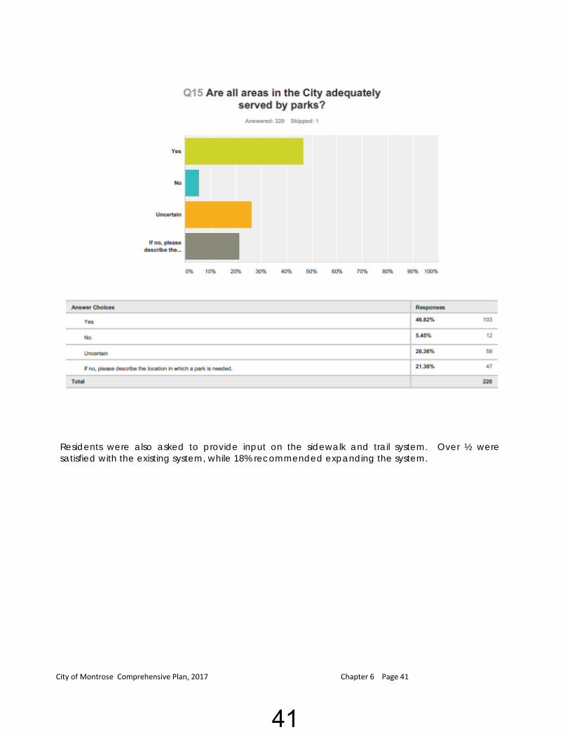
IX. PUBLIC INPUT Parks and Recreation. In 2016, an on-line survey was conducted with 220 responses received. Residents were asked if all areas in the City are adequately served by parks. 46.8% indicated they are, 5.4% noted they are not and 26.36% were uncertain.
Locations proposed included Forest Creek, Pheasant Hills (enlarge) and a larger park versus the small parks.
40
City of Montrose Comprehensive Plan, 2017 Chapter 6 Page 41
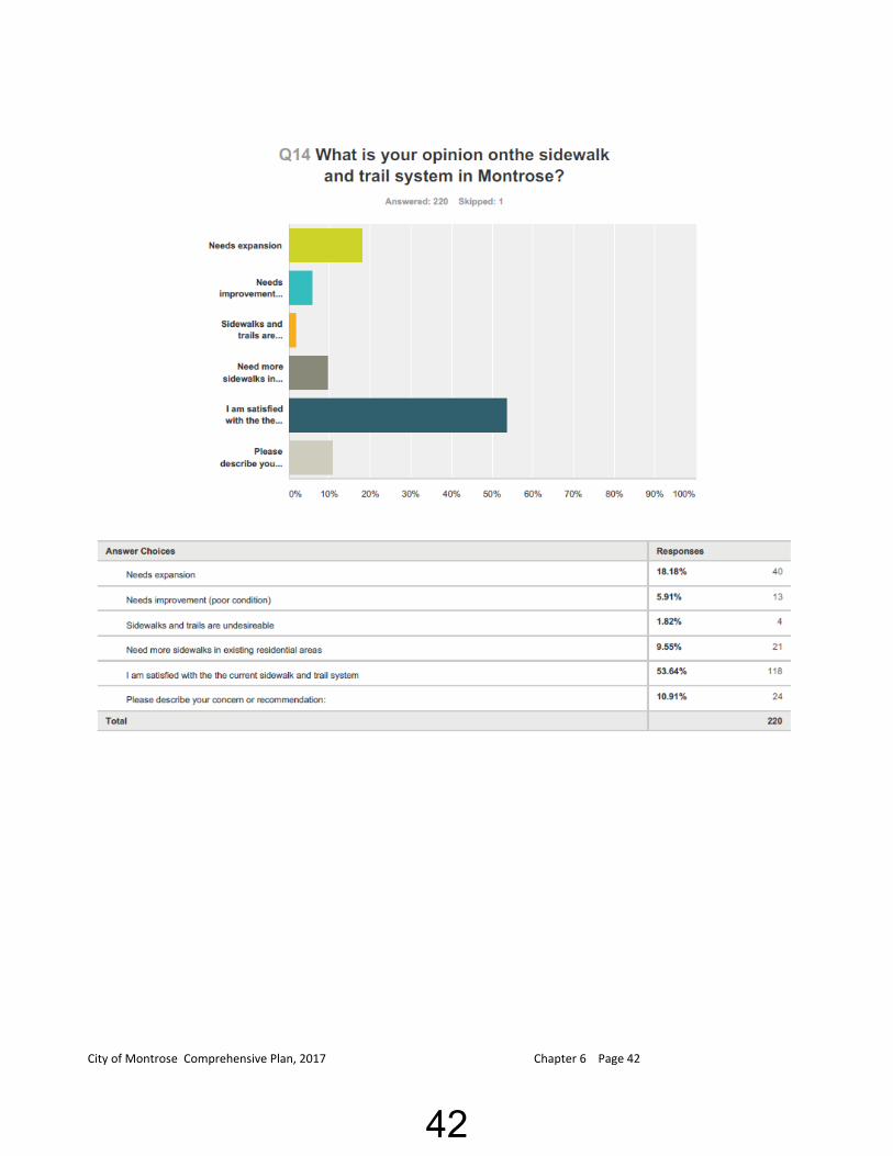
Residents were also asked to provide input on the sidewalk and trail system. Over ½ were satisfied with the existing system, while 18% recommended expanding the system.
41
City of Montrose Comprehensive Plan, 2017 Chapter 6 Page 42
42
City of Montrose Comprehensive Plan, 2017 Chapter 6 Page 43
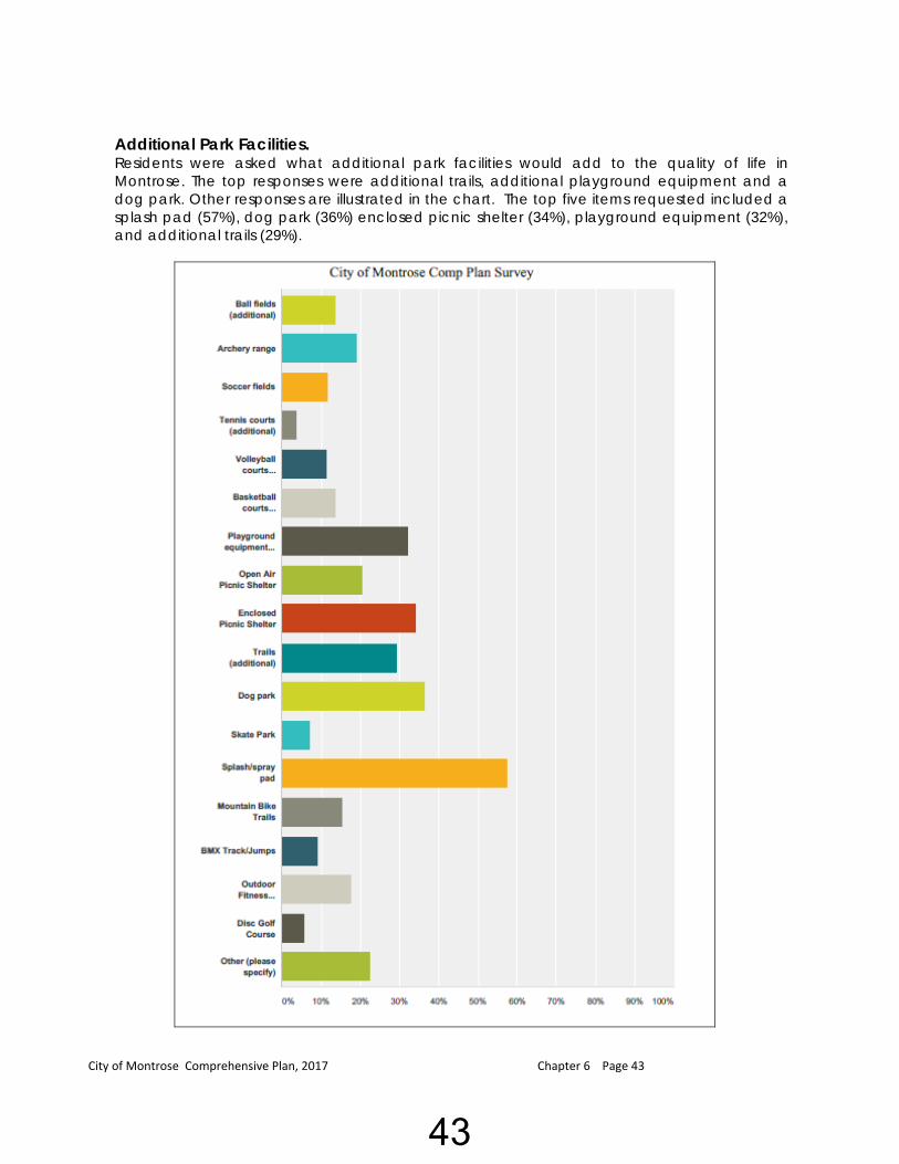
Additional Park Facilities. Residents were asked what additional park facilities would add to the quality of life in Montrose. The top responses were additional trails, additional playground equipment and a dog park. Other responses are illustrated in the chart. The top five items requested included a splash pad (57%), dog park (36%) enclosed picnic shelter (34%), playground equipment (32%), and additional trails (29%).
43
City of Montrose Comprehensive Plan, 2017 Chapter 6 Page 44
X. ADMINISTRATION, MAINTENANCE AND OPERATIONS
A. Park Commission. The City Council has appointed a Park Commission, which meets monthly to plan for the development and redevelopment of Montrose’s park and trail system. The Montrose Park Commission reviews current and future community park and recreation needs, programs and facilities and recommends policies and improvements to promote the implementation of the City’s parks, trails, and recreational plans. The City Public Works Director serves as the staff to the Park Commission.
B. The City of Montrose’s Public Works Department maintains the city parks.
Full-time employees assist with mowing, maintenance of the parks and restrooms within and trail cleaning.
In addition to City staff, various volunteers and volunteer organizations assist in park
maintenance and improvements. C. Future Needs for Administration, Maintenance and Operations. A Trail Replacement and Seal Coating Plans are recommended which includes the age of
the trail segment, its condition and plans for seal coating. This should be incorporated into a larger Park and Trail Capital Improvement Plan.
The City should continue to evaluate staffing needs as well as intergovernmental sharing of staff and equipment as the number of park acres and miles of trails grow.
XI. FINANCIAL RESOURCES The City budgets for operational expenses through its annual budget process. The City currently utilizes user fees, donations from organizations and individuals, grant programs, park dedication land, fees, the general tax levy, and volunteer labor to cover expenses relating to parks. Maintenance of parks is included in the general fund budget, while park dedication fees are tracked in a park dedication fund.
A. Park Land Dedication Fund. The City has a dedicated fund for park improvements. The purpose of all funds derived is to pay for all or part of the acquisition of parkland, park equipment and park improvements as established by the City Council. All revenues derived from the park land dedication fees are credited to the Park Land Dedication Fund.
Park Land Dedication Ordinance. MN State Statute 462.358 subdivision 2b, grants cities the authority to, “require that a reasonable portion of the buildable land, as defined by municipal ordinance, of any proposed subdivision be dedicated to the public or preserved for public use as streets, roads, sewers, electric, gas, and water facilities, storm water drainage and holding areas or ponds and similar utilities and improvements, parks,
44

City of Montrose Comprehensive Plan, 2017 Chapter 6 Page 45
recreational facilities as defined in section 471.191, playgrounds, trails, wetlands, or open space.” Statutes require that, “If a municipality adopts the ordinance or proceeds under section 462.353, subdivision 4a, as required by paragraph (a), the municipality must adopt a capital improvement budget and have a parks and open space plan or have a parks, trails, and open space component in its comprehensive plan…”
The City’s Subdivision Ordinance includes parkland dedication requirements. At the time of this Chapter, new subdivisions are required to dedicate 10% of the land being platted or a fee-in-lieu of the land equal to the value.
B. Grants. The city has an opportunity to apply for a number of park and trail grants. These
include but are not limited to the DNR Outdoor Recreation Grant Program, Walkable Community Program, MnDOT Community Roadside Landscape Grant, MnDOT Transportation Enhancement Grant and DNR Grant for the Prairie Restoration. A further explanation of possible grants is included within the 2015 Master Park and Trail Plan.
XII. GOALS AND RECOMMENDATIONS FOR PARKS, TRAILS AND RECREATION Parks, Trails and Recreation Plan The Master Park and Trail Plan, adopted in December, 2015 has identified the following Goals and Recommendations:
OVERALL SYSTEM POLICIES
1. Develop an ongoing planning process for the establishment and development of parks
and trails which responds to the Comprehensive Land Use Plan policies as well as those identified herein.
2. Develop goals and priorities for park/trail acquisition and development. 3. Identify present and future park/trail needs on a continual basis for evaluation by the
Planning Commission as development proposals are considered and recommendations are made to the City Council.
4. Update physical plans and related documents as necessary to respond to changes in
goals, needs, priorities, and budget.
5. Plan for recreational facilities and budget needs by preparing a master plan for each component of the park/trail system to be used as the basis for development.
6. Promote public participation in the planning process via the Planning Commission to host
a forum for open discussion of issues.
7. Promote integration with other City activities, services, and facilities.
8. Identify the means by which to implement park/trail administration and operations (i.e., by the Parks Commission, Planning Commission, and City Council policies, procedures, and ordinances).
45
City of Montrose Comprehensive Plan, 2017 Chapter 6 Page 46
9. The Parks Commission shall review and make recommendation to the Planning Commission and City Council on all aspects of park/trail planning, design, acquisition, development, and maintenance.
10. The City shall achieve an equitable distribution of park lands, trails, recreational facilities,
and programs throughout the community.
11. Develop a system of directional park signage. New signage is in place at each city park showing its name & the rules, but additional consideration has been given to more signage showing "all" parks, their location, and amenities contained therein.
ACQUISITION
1. Dedication of land for park and open space facilities shall be accepted only when the land satisfies the needs of the community.
2. Pursue park and recreation grants to acquire park and trail land and improve existing
parks/trails. 3. The Parks Commission shall review and submit recommendations to the City Council on
all park and trail land acquisition issues. 4. When financially feasible, the City shall acquire and reserve sufficient park and open
space lands to fulfill the needs of the present and projected future population of the community.
5. New recreation sites shall be pursued in association with new residential subdivisions
which serve a broad range of age groups and activities. 6. Proper right-of-way widths shall be dedicated for sidewalks and trails during the
subdivision process. 7. Developers shall provide sidewalks or trails on both sides of all new collector streets within
their development with projected average daily trips (ADT) above 500.
8. Park and open space shall be developed and improved to take maximum advantage of natural community features, including lake frontage, forests, native prairie, other unique vegetation associations, or areas of rugged topography with quality views and vistas.
9. Park and open space facilities shall be planned and developed in coordination with
similar services or surrounding communities. 10. Portions of a parcel that are within delineated wetlands or include slopes of more than 12
percent shall not be credited for dedication of park and trail lands. 11. Developers with land abutting a minor arterial or collector street shall construct a
bituminous trail in accordance with City design standards. If said street leads to a major park, school, commercial center or other majority activity area, the City may
46
City of Montrose Comprehensive Plan, 2017 Chapter 6 Page 47
require construction of a concrete sidewalk in place of the bituminous trail. 12. Costs for the construction of park facilities or of sidewalks and trails shall be borne by
those that benefit from the improvements.
PROGRAMMING / DEVELOPMENT
1. An appropriate balance between active, passive, and cultural recreational areas and activities, tailored to the needs of the total population throughout the community shall be provided.
2. When financially feasible, recreational facilities and a year-round program of activities
shall be provided which are suited to the varied recreational needs of all age groups within the community.
3. When financially feasible, providing safe and convenient, pedestrian and bicycle
access to recreational facilities shall be considered a high priority.
4. When possible, construct trails in conjunction with State, County, and City street improvements to minimize construction costs.
5. The City shall gauge capital improvements made to individual park facilities on the
basis of relative need for developed park facilities.
6. Recreational open space improvements shall be programmed in accordance with a Capital I improvement Program and updated on an annual basis.
7. On a periodic basis, the City shall undertake studies to analyze the effectiveness and
comprehensiveness of the community recreation program.
FACILITY PURPOSE AND DESIGN
1. The City shall classify and make any improvements to the park system utilizing a
classification system defined by the Parks and Trails Plan. 2. Trails corridors shall serve transportation and/or recreational functions. The transportation
function of a trail corridor is to provide as direct a link possible between population areas and activity centers such as schools, parks, churches, places of work, and shopping areas. They generally will occur adjacent to collector and minor arterial streets. Trails with a recreational focus shall be developed in places of interest such as natural areas, parks, creek corridors, around lakes, or other areas suited to recreational use.
3. Consider the long term costs of maintenance and operation in a recreational facility's
design and development. The City, along with Public Works, has implemented a plan. 4. Neighborhood and community scale recreational facilities shall be located within safe
and easy access of users.
47
City of Montrose Comprehensive Plan, 2017 Chapter 6 Page 48
5. Parks shall be designed and maintained with proper lighting, landscaping, shelter design, etc. to ensure a high degree of public and property safety.
6. The use of motorized recreational vehicles shall be subject to applicable City regulations
and limited to designated areas. 7. Where necessary, park and open space areas shall be buffered and screened via a
fence, berm, plantings, or a combination thereof for the safety and protection of the user.
8. Adequate parking shall be provided to serve major park and recreational facilities.
9. The slope of trails along their length should not exceed 5 percent to be considered
disability accessible and 8 to 10 percent in areas where access would otherwise be limited.
10. The recreational needs of the disabled shall be considered and incorporated in park
designs, and will be a major consideration in development of the Regional Park. MAINTENANCE AND OPERATION 1. Provide a safe and sanitary environment in all park facilities and trail systems under the
direction of the City. 2. Provide an effective system of controlled and consistent maintenance to safeguard the
condition of all park and trail facilities. 3. The City will coordinate maintenance of park and trail facilities to insure their availability
for safe use. RECREATION PROGRAM POLICIES 1. Cooperative agreements with the School District shall be established for provision of
recreational open space areas, athletic programs and services. 2. Work with surrounding communities to utilize existing facilities within Montrose and
surrounding communities to provide opportunities for recreational activities. 3. Insure cooperation with local civic groups that show interest in providing services and
events that benefit the community's recreation needs. 4. Establish a system of providing recreational services which satisfy the needs of all ages
and abilities. 5. Accept gifts and donations (i.e. cash, building materials, etc.) for recreation programs if
they are determined to be in the City's best interest.
48
City of Montrose Comprehensive Plan, 2017 Chapter 6 Page 49
PUBLIC RELATIONS / COMMUNITY ISSUES
1. The City shall encourage continued citizen participation in the planning, development and operation of recreational open space.
2. Educate residents and facility users on the proper use and safety rules for each
facility.
3. Use print and broadcast media, the local newspaper, the City's promotional packet, and informational signs to promote facilities and recreational programs.
4. Develop a clear and concise system of trail graphics and signage that direct people
along trails and into parks to specific points of interest.
5. Develop ways to organize recreation programs and facilities to max1m1ze participation and overcome physical or economic limitations that may prevent equal opportunity for all citizens.
This Chapter is intended to be a guide for the development of parks and trails and recreational programs within the community. As events and circumstances within the community change, the Chapter should be reviewed and updated, as appropriate. Amendments should be considered if there have been significant changes within the community or opportunities arise which were not anticipated by the Chapter.
49

1 23
456
78
9 10
11
12
13
14
GkWX
)n
?¾A@
Sé
Map Date: November 27, 2016
ParksCity LimitsWater
0 0.2 0.4 0.60.1Miles
1 - White Tail Ridge Park2 - Forest Creek Park3 - Rolling Meadows Park4 - Northridge Park5 - Lent Park6 - Parkview Park A7 - Parkview Park B
8 - Thorson Park9 - Carver Field10 - Veterans Park11 - Pheasant Hills Park12 - Lions Park13 - Preserve of Montrose Park14 - Rock Brook Park
Montrose Parks
City of MontroseMap 6-1
City Parks
50
1 23
456
78
9 10
11
12
13
14
GkWX
)n
?¾A@
Sé
Map Date: November 27, 2016
1/4 Mile Buffer1/2 Mile Buffer1 Mile Buffer2 Mile BufferParksCity LimitsWater
0 0.2 0.4 0.60.1Miles
1 - White Tail Ridge Park2 - Forest Creek Park3 - Rolling Meadows Park4 - Northridge Park5 - Lent Park6 - Parkview Park A7 - Parkview Park B
8 - Thorson Park9 - Carver Field10 - Veterans Park11 - Pheasant Hills Park12 - Lions Park13 - Preserve of Montrose Park14 - Rock Brook Park
Montrose Parks
City of MontroseMap 6-2
Park Service Areas
51
1 23
456
7 8
9 10
11
12
13
14
GkWX
)n
?¾A@
Sé
Map Date: November 27, 2016
Park Search AreasParksCity LimitsWater
0 0.25 0.5 0.750.125Miles
1 - White Tail Ridge Park2 - Forest Creek Park3 - Rolling Meadows Park4 - Northridge Park5 - Lent Park6 - Parkview Park A7 - Parkview Park B
8 - Thorson Park9 - Carver Field10 - Veterans Park11 - Pheasant Hills Park12 - Lions Park13 - Preserve of Montrose Park14 - Rock Brook Park
Montrose Parks
City of MontroseMap 6-3
Park Search Areas
52
1 23
456
78
9 10
11
12
13
14
GkWX
)n
?¾A@
Sé
Map Date: November 27, 2016
Existing Sidewalks & TrailsParksCity LimitsWater
0 0.2 0.4 0.60.1Miles
1 - White Tail Ridge Park2 - Forest Creek Park3 - Rolling Meadows Park4 - Northridge Park5 - Lent Park6 - Parkview Park A7 - Parkview Park B
8 - Thorson Park9 - Carver Field10 - Veterans Park11 - Pheasant Hills Park12 - Lions Park13 - Preserve of Montrose Park14 - Rock Brook Park
Montrose Parks
City of MontroseMap 6-4
Existing Sidewalks and Trails
53
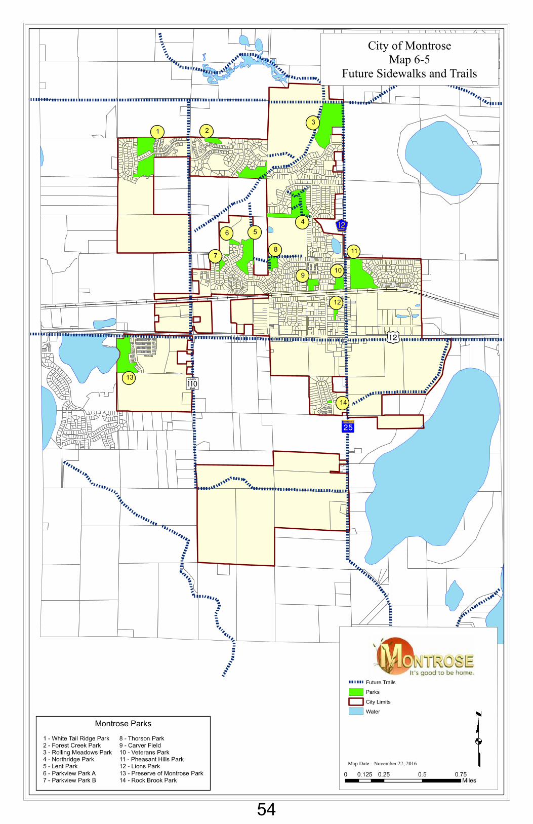
1 23
456
7 8
9 10
11
12
13
14
GkWX
)n
?¾A@
Sé
Map Date: November 27, 2016
Future TrailsParksCity LimitsWater
0 0.25 0.5 0.750.125Miles
1 - White Tail Ridge Park2 - Forest Creek Park3 - Rolling Meadows Park4 - Northridge Park5 - Lent Park6 - Parkview Park A7 - Parkview Park B
8 - Thorson Park9 - Carver Field10 - Veterans Park11 - Pheasant Hills Park12 - Lions Park13 - Preserve of Montrose Park14 - Rock Brook Park
Montrose Parks
City of MontroseMap 6-5
Future Sidewalks and Trails
54
City of Montrose Comprehensive Plan, 2017 Chapter 11 Page 1
LAND USE
I. INTRODUCTION Montrose’s close proximity to the Twin Cities metropolitan area, rural character, more affordable land costs and the absence of development limitations, make it an attractive place for homes and businesses. As a result, Montrose experienced significant growth from 2000-2007. With growth anticipated to return, it is important to plan for logical and efficient commercial, recreational, industrial and residential growth. This chapter includes an inventory and analysis of existing land uses by type and volume, examines development and redevelopment issues, includes forecasts for land use volumes to support future growth, and includes future land use policies and the staging of future municipal boundary expansions through annexation.
II. LAND USE INVENTORY In order to plan for the future development of Montrose, it is useful to examine the existing patterns of land use in the city. The land use inventory quantifies existing development in the city. The type of development and how that development is allowed to progress should be a reflection of the community’s needs and desires. Map 11-1 illustrates the zoning classification for parcels within the community. Table 11.1 shows Montrose’s historical land use make up and existing land uses by acreage, as of September, 2016. Acreages are given as “gross acres” which is the total acreage, including water and wetlands. Montrose is about 3.21 square miles in size, or twice the geographic size it was in 2005, when it was 1.57 square miles. As illustrated in Table 11-1, growth over the past 11 years has primarily occurred in the low density and medium density residential categories. Since 2005, the city has included over 260 additional acres of low density residential land. The commercially zoned land has increased by 42%. Industrial zoned acreage has grown from 40.88 acres to 56.47 acres. The following table includes the land use by zoning category.
55
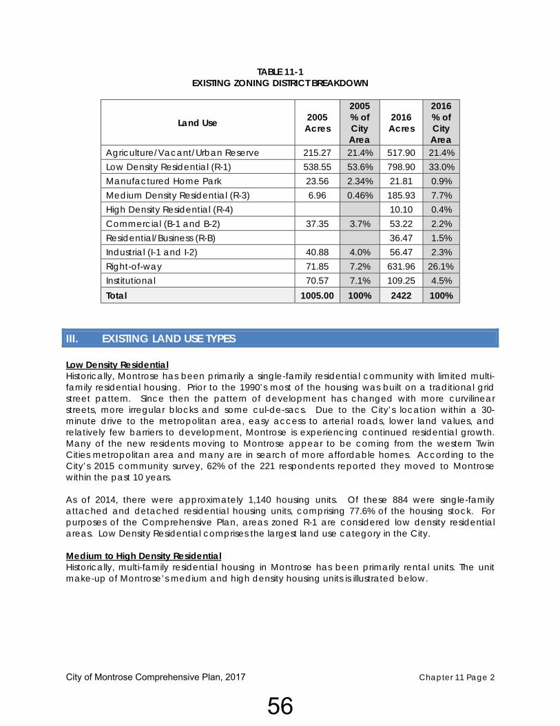
City of Montrose Comprehensive Plan, 2017 Chapter 11 Page 2
TABLE 11-1 EXISTING ZONING DISTRICT BREAKDOWN
Land Use 2005 Acres
2005 % of City Area
2016 Acres
2016 % of City Area
Agriculture/Vacant/Urban Reserve 215.27 21.4% 517.90 21.4% Low Density Residential (R-1) 538.55 53.6% 798.90 33.0% Manufactured Home Park 23.56 2.34% 21.81 0.9% Medium Density Residential (R-3) 6.96 0.46% 185.93 7.7% High Density Residential (R-4) 10.10 0.4% Commercial (B-1 and B-2) 37.35 3.7% 53.22 2.2% Residential/Business (R-B) 36.47 1.5% Industrial (I-1 and I-2) 40.88 4.0% 56.47 2.3% Right-of-way 71.85 7.2% 631.96 26.1% Institutional 70.57 7.1% 109.25 4.5% Total 1005.00 100% 2422 100%
III. EXISTING LAND USE TYPES Low Density Residential Historically, Montrose has been primarily a single-family residential community with limited multi-family residential housing. Prior to the 1990’s most of the housing was built on a traditional grid street pattern. Since then the pattern of development has changed with more curvilinear streets, more irregular blocks and some cul-de-sacs. Due to the City’s location within a 30-minute drive to the metropolitan area, easy access to arterial roads, lower land values, and relatively few barriers to development, Montrose is experiencing continued residential growth. Many of the new residents moving to Montrose appear to be coming from the western Twin Cities metropolitan area and many are in search of more affordable homes. According to the City’s 2015 community survey, 62% of the 221 respondents reported they moved to Montrose within the past 10 years. As of 2014, there were approximately 1,140 housing units. Of these 884 were single-family attached and detached residential housing units, comprising 77.6% of the housing stock. For purposes of the Comprehensive Plan, areas zoned R-1 are considered low density residential areas. Low Density Residential comprises the largest land use category in the City. Medium to High Density Residential Historically, multi-family residential housing in Montrose has been primarily rental units. The unit make-up of Montrose’s medium and high density housing units is illustrated below.
56
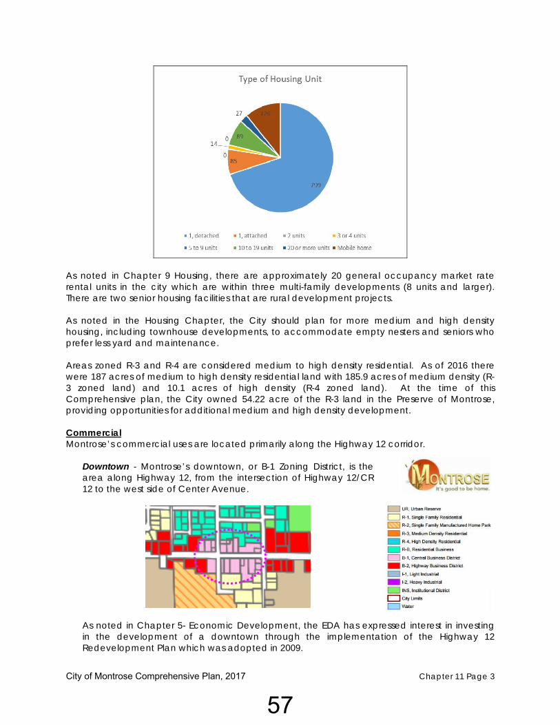
City of Montrose Comprehensive Plan, 2017 Chapter 11 Page 3
As noted in Chapter 9 Housing, there are approximately 20 general occupancy market rate rental units in the city which are within three multi-family developments (8 units and larger). There are two senior housing facilities that are rural development projects. As noted in the Housing Chapter, the City should plan for more medium and high density housing, including townhouse developments, to accommodate empty nesters and seniors who prefer less yard and maintenance. Areas zoned R-3 and R-4 are considered medium to high density residential. As of 2016 there were 187 acres of medium to high density residential land with 185.9 acres of medium density (R-3 zoned land) and 10.1 acres of high density (R-4 zoned land). At the time of this Comprehensive plan, the City owned 54.22 acre of the R-3 land in the Preserve of Montrose, providing opportunities for additional medium and high density development. Commercial Montrose’s commercial uses are located primarily along the Highway 12 corridor.
Downtown - Montrose’s downtown, or B-1 Zoning District, is the area along Highway 12, from the intersection of Highway 12/CR 12 to the west side of Center Avenue.
As noted in Chapter 5- Economic Development, the EDA has expressed interest in investing in the development of a downtown through the implementation of the Highway 12 Redevelopment Plan which was adopted in 2009.
57
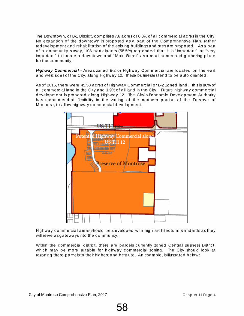
City of Montrose Comprehensive Plan, 2017 Chapter 11 Page 4
The Downtown, or B-1 District, comprises 7.6 acres or 0.3% of all commercial acres in the City. No expansion of the downtown is proposed as a part of the Comprehensive Plan, rather redevelopment and rehabilitation of the existing buildings and sites are proposed. As a part of a community survey, 108 participants (58.5%) responded that it is “important” or “very important” to create a downtown and “Main Street” as a retail center and gathering place for the community. Highway Commercial - Areas zoned B-2 or Highway Commercial are located on the east and west sides of the City, along Highway 12. These businesses tend to be auto oriented. As of 2016, there were 45.58 acres of Highway Commercial or B-2 Zoned land. This is 86% of all commercial land in the City and 1.9% of all land in the City. Future highway commercial development is proposed along Highway 12. The City’s Economic Development Authority has recommended flexibility in the zoning of the northern portion of the Preserve of Montrose, to allow highway commercial development.
Highway commercial areas should be developed with high architectural standards as they will serve as gateways into the community. Within the commercial district, there are parcels currently zoned Central Business District, which may be more suitable for highway commercial zoning. The City should look at rezoning these parcels to their highest and best use. An example, is illustrated below:
58
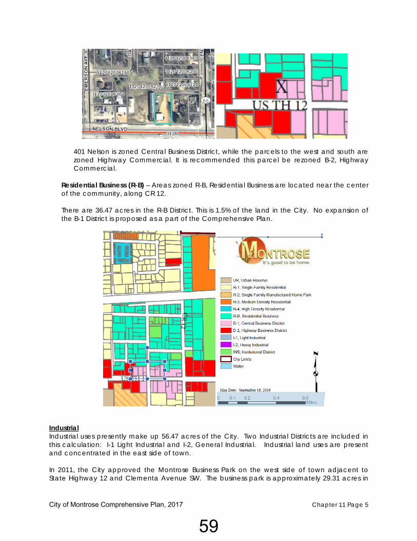
City of Montrose Comprehensive Plan, 2017 Chapter 11 Page 5
401 Nelson is zoned Central Business District, while the parcels to the west and south are zoned Highway Commercial. It is recommended this parcel be rezoned B-2, Highway Commercial.
Residential Business (R-B) – Areas zoned R-B, Residential Business are located near the center of the community, along CR 12. There are 36.47 acres in the R-B District. This is 1.5% of the land in the City. No expansion of the B-1 District is proposed as a part of the Comprehensive Plan.
Industrial Industrial uses presently make up 56.47 acres of the City. Two Industrial Districts are included in this calculation: I-1 Light Industrial and I-2, General Industrial. Industrial land uses are present and concentrated in the east side of town. In 2011, the City approved the Montrose Business Park on the west side of town adjacent to State Highway 12 and Clementa Avenue SW. The business park is approximately 29.31 acres in
59

City of Montrose Comprehensive Plan, 2017 Chapter 11 Page 6
size and includes land for highway commercial development as well as industrial development. Additional industrial is proposed to the west, along Highway 12.
Public/Semi Public Public land uses make up an important portion of the existing land. This category includes the regional park, city’s wastewater treatment ponds and the elementary school. Additional information on municipal and semi-public land uses may be found in Chapter 10. No additional land is guided for public or semi-public uses, rather infill or development on existing sites is proposed.
Parks and Open Space The City of Montrose’s Park and Recreational land uses include thirteen city owned parks, as well as other open space and recreational areas. These land uses account for approximately 111.18 acres or 4.5% of the City’s total acreage. Parks and open spaces include both active recreational areas, such as ballfields, as well as nature areas for passive recreation. As the City grows, additional parks will be needed to serve the City. Park Search Areas have been identified on Map 6-3. Additional information on parks and open spaces may be found in Chapter 6.
60

City of Montrose Comprehensive Plan, 2017 Chapter 11 Page 7
IV. FUTURE LAND USE PLAN The Comprehensive Plan provides a framework for growth and development in Montrose over the next twenty-three years, to 2040. This plan focuses on providing additional areas for residential, commercial, and industrial growth in the Montrose area while recognizing the importance of developing a downtown and maintaining existing residential neighborhoods. Revitalizing & redeveloping the downtown area can become a focal point for the city and for visitors as the primary location for service, retail, restaurant and multi-family uses and can in part absorb some of the needed additional commercial growth. In general, determining the proper amount of commercial/industrial land use is difficult with changing trends, regional influences and because commercial/industrial growth typically lags behind residential growth. The City should continue to analyze the need for additional commercial/industrial expansion and can make adjustments to zoning over time. REDEVELOPMENT/INFILL POTENTIAL
The City should emphasize the use of currently available sites within the City limits prior to the annexation and platting of new sites. The development of sites within the serviced area will ensure prudent land management, assist in the prevention of ‘leap-frog’ type development and ensure maximum cost effectiveness for community residents. Additionally, efforts should be made to ensure proper placement and phasing of urban expansion and the maintenance of existing and future land use compatibility. Potential redevelopment areas are primarily centered in or near the City’s core. The City should focus redevelopment efforts on commercial and residential areas/parcels in the more established areas of the City. To achieve this, the City should:
1. Encourage the removal of existing buildings that have exceeded their useful life, or
2. Encourage or participate in the removal of those which are deemed to have a “blighting effect” upon adjacent properties and/or present nuisance conditions that pose a threat to health and safety of citizens; or
3. Promote appropriate re-uses for under-utilized properties.
Infill. There are 1,139 vacant residential lots with streets and utilities in place, and utilities provided, ready for residential development. The following table identifies the residential subdivisions with final plats approved and the number of available lots within each.
61
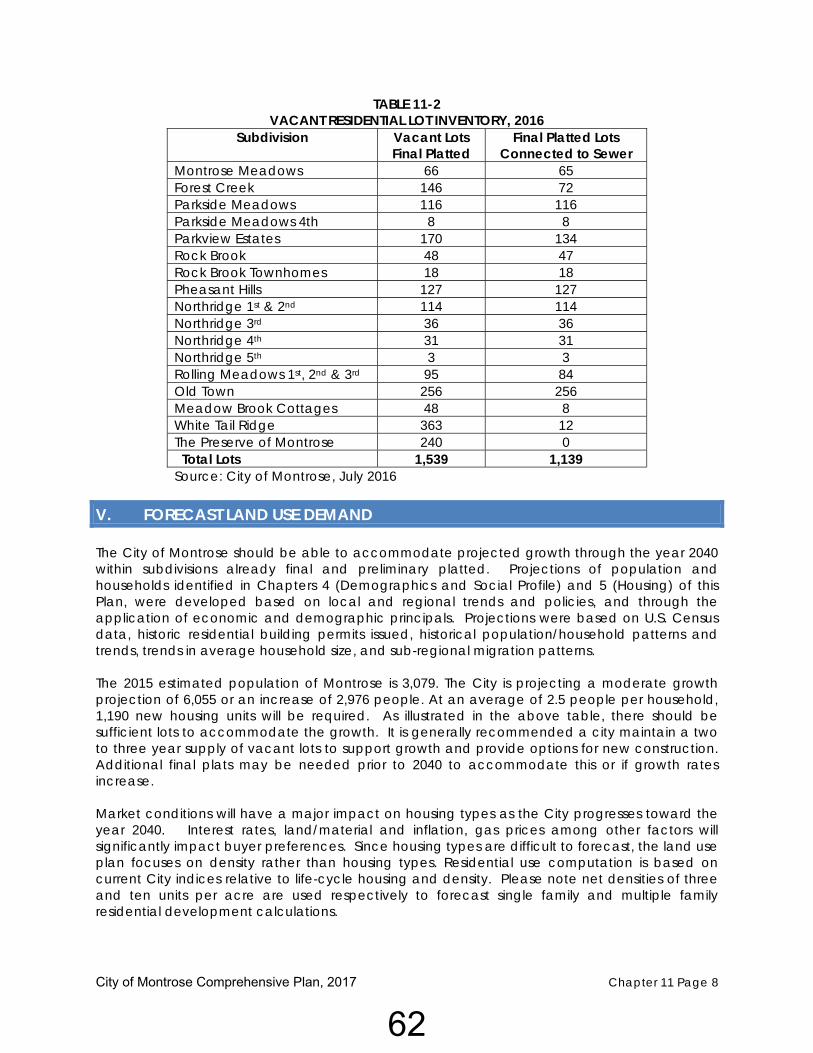
City of Montrose Comprehensive Plan, 2017 Chapter 11 Page 8
TABLE 11-2 VACANT RESIDENTIAL LOT INVENTORY, 2016
Subdivision Vacant Lots Final Platted
Final Platted Lots Connected to Sewer
Montrose Meadows 66 65 Forest Creek 146 72 Parkside Meadows 116 116 Parkside Meadows 4th 8 8 Parkview Estates 170 134 Rock Brook 48 47 Rock Brook Townhomes 18 18 Pheasant Hills 127 127 Northridge 1st & 2nd 114 114 Northridge 3rd 36 36 Northridge 4th 31 31 Northridge 5th 3 3 Rolling Meadows 1st, 2nd & 3rd 95 84 Old Town 256 256 Meadow Brook Cottages 48 8 White Tail Ridge 363 12 The Preserve of Montrose 240 0 Total Lots 1,539 1,139 Source: City of Montrose, July 2016
V. FORECAST LAND USE DEMAND The City of Montrose should be able to accommodate projected growth through the year 2040 within subdivisions already final and preliminary platted. Projections of population and households identified in Chapters 4 (Demographics and Social Profile) and 5 (Housing) of this Plan, were developed based on local and regional trends and policies, and through the application of economic and demographic principals. Projections were based on U.S. Census data, historic residential building permits issued, historical population/household patterns and trends, trends in average household size, and sub-regional migration patterns. The 2015 estimated population of Montrose is 3,079. The City is projecting a moderate growth projection of 6,055 or an increase of 2,976 people. At an average of 2.5 people per household, 1,190 new housing units will be required. As illustrated in the above table, there should be sufficient lots to accommodate the growth. It is generally recommended a city maintain a two to three year supply of vacant lots to support growth and provide options for new construction. Additional final plats may be needed prior to 2040 to accommodate this or if growth rates increase. Market conditions will have a major impact on housing types as the City progresses toward the year 2040. Interest rates, land/material and inflation, gas prices among other factors will significantly impact buyer preferences. Since housing types are difficult to forecast, the land use plan focuses on density rather than housing types. Residential use computation is based on current City indices relative to life-cycle housing and density. Please note net densities of three and ten units per acre are used respectively to forecast single family and multiple family residential development calculations.
62
City of Montrose Comprehensive Plan, 2017 Chapter 11 Page 9
VI. LAND USE PLAN CATEGORIES Low Density Residential The purpose of this category is to identify portions of Montrose and its growth areas that contain or should be developed at residential densities of 2 to 4 dwelling units per acre, net of wetlands and major road right-of-way. Low Density Residential includes the older, smaller lot, primarily single-family neighborhoods and existing suburban style, single-family subdivisions, duplexes and twin homes. It will also guide the development of new subdivisions in the city’s planned growth areas. Areas designated as Low Density Residential will be primarily single-family detached homes, but may include limited amounts of twin homes and duplexes in appropriate areas and mixed uses in the form of a traditional subdivision design with a mix of single family, duplexes, townhouses and some apartments as part of a single development. Map 11-2, Future Land Use, illustrates the proposed locations of future low density residential housing. Medium to High Density Residential The purpose of this category is to identify portions of Montrose and its growth areas that contain or should be developed at residential densities of 3-12 units per acre for medium density and over 12 units per acre for higher density residential, net of wetlands and major road right-of-way. Medium Density Residential is intended to accommodate primarily town-home complexes, apartments, and other multi-family development. Locations for proposed medium and high density residential development are illustrated on Map 11-2. Highway Commercial The purpose of this category is to identify portions of Montrose and its growth areas that contain or should be developed for general commercial use. Examples of these could include highway-oriented businesses such as restaurants, convenience stores, gas stations and other auto-oriented businesses and large retailers. Limited office and service uses are appropriate in these areas as well. The 2040 Plan envisions additional Highway Commercial along the major roadways including TH 12, CR 12 and CR 110. Downtown Commercial The purpose of this category is to develop a traditional mixed-use commercial core in the City. The downtown area has good access via vehicle and pedestrian traffic. Land uses could include small-scale commercial development (retail, office) and civic uses. New development within this district should take into consideration pedestrian areas, architectural character, streetscape improvements, move buildings close to the street with parking located in the rear or in shared or structured parking, use decorative lighting, etc. (See Chapter 5 - Economic Development for Downtown Revitalization). Industrial The purpose of this category is to identify portions of Montrose and its growth areas that contain or should be developed for industrial use. Land uses could include manufacturing, warehousing, business service and assembly.
63
City of Montrose Comprehensive Plan, 2017 Chapter 11 Page 10
The 2040 Plan recognizes the importance of industrial development with local tax base and employment opportunities. At this time, there are available industrial lots, within a privately owned industrial park, Montrose Business Park. As these lot are sold and developed, the City should continue to pursue industrial development. The future location for industrial development has been identified on the east side of the community, along TH 12 as well as along the south side of the city, along the east side of Highway 25. Parks and Open Space Montrose currently has 13 City-owned parks. The regional park is proposed to be developed on the north side of the City. Chapter 6 identifies locations for future park search areas. Public/Semi-Public As noted in Chapter 8 – Community Facilities and Services, there is a need to plan for an expanded/new fire hall facility. As the City grows, the city should also evaluate the city offices and community center spaces.
VII. LONG TERM GROWTH AREA - 2040 PLAN ANNEXATION The City’s AUAR has identified future land uses and future city boundaries. The city is projected to expand within Marysville, Woodland and Franklin Townships. The City of Montrose has orderly annexation agreements in place with Marysville and Woodland Townships. The areas identified in the orderly annexation agreements correspond with the boundary in the AUAR. The “Interim Build” scenario, which is reflected on Map 11-2 as the Future Land Use Map will accommodate a population of approximately 21,000 with 8,585 households, employment of 3,358 retail and 4,94 non-retail jobs.1 It should be noted, this Comprehensive Plan projects a 2040 population of 6,055 to 7,500. The Future Land Use Map or Interim Build Map proactively plans for growth beyond 2040. The city has prepared a plan to guide the future use of land throughout the existing city and identified annexation areas. In the city proper, the guiding of land primarily follows the existing use of land or the existing zoning of the land. Areas guided for new development within the Montrose Growth Areas are based on current development patterns, existing and proposed transportation networks, availability of sanitary sewer and surrounding land uses, and the AUAR.
VIII. LAND USE AND GROWTH GOALS AND STRATEGIES
As a part of the Community Visioning Session, participants identified a desire to develop the city as, “A comfortable and progressive, self-reliant community, living in harmony with nature and family values.”. In order to accomplish this the following principles have been developed:
1 Montrose AUAR, October 2008, Table 7‐5 Staging Scenerios, Bolton & Menk
64
City of Montrose Comprehensive Plan, 2017 Chapter 11 Page 11
Preserve the spirit of a small town. The goal of retaining the small town atmosphere is included through a logical pattern of future land use in an organized fashion, along with a transportation system to support the various land uses, parks and recreation and quality educational facilities to offer quality of life amenities.
A proactive position on future growth – The future land use plan includes projections and
growth boundaries intended to serve the City to the year 2040, and beyond. As market demands change the plan may need periodic review and updates. The future land use plan has been coordinated with the AUAR to encourage proactive planning of land uses with infrastructure and the funding of the infrastructure. Additional information on utility needs is included in the Utility Chapter of this Comprehensive Plan.
A well-balanced tax base – In order to assist with the fiscal health of the city and discourage the future development of a bedroom community for other suburbs with employment offerings, a range of land uses including commercial and industrial have been planned.
Proactive Planning - It is the intent of this Plan to facilitate or create a community within
which these elements exist: o A variety of housing types, o Adequate parks, trails and community facilities, o An efficient transportation system, o An orderly and planned extension of municipal utilities, and o Ample business and commercial opportunities for residents and visitors alike
Land Use and Growth Goal #1 Support the compact, efficient and orderly growth of residential, commercial and industrial land uses. Strategies:
1. Encourage infill on existing vacant lots and redevelopment of underutilized lots. 2. Coordinate growth and development with logical and phased extension of municipal
utilities and public streets. Avoid “leap frog” development. 3. Protect significant natural resources which benefit the community and incorporate these
into passive recreational areas. 4. Encourage the development of additional commercial and industrial areas within the
city in accordance with the 2040 Comprehensive Land Use Plan. 5. Have new development pay the public infrastructure, parks, trails and service costs
necessary to support the development. Land Use and Growth Goal #2 Protect natural resources without restricting community growth. Strategies:
1. Protect gateways into the community with higher design standards, landscaping and architectural guidelines.
2. Protect natural resources such as tree lines, wetlands, creeks, etc. through appropriately located new parks, buffers and open space areas.
65
City of Montrose Comprehensive Plan, 2017 Chapter 11 Page 12
Land Use and Growth Goal #3 Basic Planning Provisions:
1. Zone all property in accordance with this Comprehensive Plan. 2. Connect existing and new residential neighborhoods, park and community facilities, with
new neighborhoods, downtown, new commercial areas, schools, and other points of interest with walking and/or recreational trails.
3. Work with County and State transportation departments to ensure appropriate street access to all existing and future development in the city and the Montrose Orderly Annexation Areas.
66
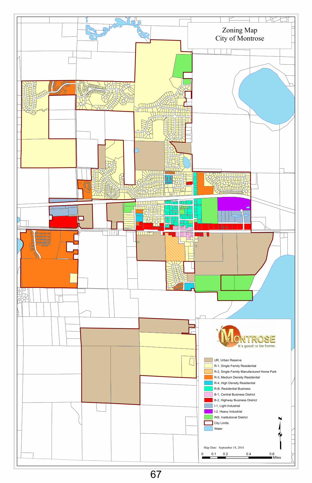
Zoning MapCity of Montrose
Map Date: September 18, 2016
UR, Urban ReserveR-1, Single Family ResidentialR-2, Single Family Manufactured Home ParkR-3, Medium Density ResidentialR-4, High Density ResidentialR-B, Residential BusinessB-1, Central Business DistrictB-2, Highway Business DistrictI-1, Light IndustrialI-2, Heavy IndustrialINS, Institutional DistrictCity LimitsWater
0 0.2 0.4 0.60.1Miles
67
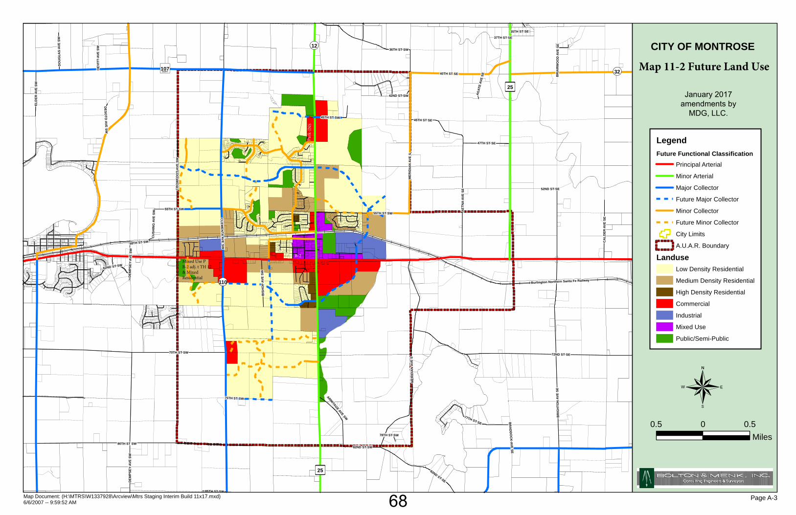
QR32
Æÿ25
Æÿ25
QR110
QR12
©̈107
72ND ST SE70TH ST SW
80TH ST SW
BR
IGH
TON
AVE
SE
CLEM
ENTA AVE SW
DEM
PSE Y
AVE
SW
MER
IDIA
N A
VE S
40TH ST SE
36TH ST SW
AET
NA
AVE
SE
3
82ND ST SW
77TH ST SE
82ND ST SE
45TH ST SE
42ND ST SW
55TH ST SW
47TH ST SE
CA
LDER
AVE
SE
CR
OW
FOO
T AV
E SW
A
BIS
HO
P AV
E SW
ARMITAGE AVE SW
45TH ST SW
DO
UG
LAS
AVE
SW
85TH ST SW
62ND ST SW
58TH ST SW
AG
ATE
AVE
SE
35TH ST SE
DESO
TO AVE SW
CU
SHIN
G A
VE S
W
DEV
ITT
AVE
SW
BR
IAR
WO
OD
AV E
SE
37TH ST SE
BR
AD
DO
CK
AVE SE
52ND ST SE
78TH ST SW
ELD
ER A
VE S
W
75TH ST SW
DEM
PSEY
AVE
SW
MER
IDIA
N A
VE S
55TH ST SW
Burlington Northern Santa Fe Railway
¬
Map Document: (H:\MTRS\W1337928\Arcview\Mtrs Staging Interim Build 11x17.mxd)6/6/2007 -- 9:59:52 AM
CITY OF MONTROSE
January 2017amendments by
MDG, LLC.
0.5 0 0.5Miles
LegendFuture Functional Classification
Principal Arterial
Minor Arterial
Major Collector
Future Major Collector
Minor Collector
Future Minor Collector
City Limits
A.U.A.R. Boundary
LanduseLow Density Residential
Medium Density Residential
High Density Residential
Commercial
Industrial
Mixed Use
Public/Semi-Public
Page A-3
Map 11-2 Future Land Use
Mixed Use PB-2 adj. t TH 12 & Mixed Residential
Park
-IN
S
B-2
68
City of Montrose Comprehensive Plan, 2017 Chapter 12 Page 1
IMPLEMENTATION
I. INTRODUCTION The various chapters of the Montrose Comprehensive Plan outline the City’s overall plan for growth and redevelopment. This chapter identifies methods the City of Montrose will employ to implement the Comprehensive Plan and associated goals and objectives as identified by the community. The Implementation Chapter of Montrose’s Comprehensive Plan includes a summary of the following:
The City’s Official Controls including its Zoning Ordinance and Subdivision Ordinance; The City’s Capital Improvement Plan; Review of growth areas and annexation; and Review of the Comprehensive Plan
II. ZONING ORDINANCE The City of Montrose Zoning Ordinance includes specific regulations governing land use and an official zoning map. With formal approval of the Comprehensive Plan, the City Council recognizes the Comprehensive Plan as the ‘umbrella’ policy guiding the overall growth and redevelopment of the City of Montrose. The policies/goals identified are in part carried out through standards regarding land use set forth within the Zoning Ordinance. The City shall administer the Zoning Ordinance on an on-going basis. As required by state statutes, the City shall achieve consistency between the Comprehensive Plan and the Zoning Ordinance. Purpose: The purpose and intent of the Montrose Zoning Ordinance is outlined in as follows, “The intent of this Ordinance is to protect the public health, safety and general welfare of the community and its people through the establishment of minimum regulations in regard to the location, erection, construction, alteration and use of structures and land. Such regulations are established to protect such use areas; to promote orderly development and redevelopment; to provide adequate light, air and convenience of access to property; to prevent congestion in the public right of way; to prevent overcrowding of land and undue concentration of structures by regulating land, building, yards and density of population; to provide for compatibility of different land uses; to provide for administration of this Ordinance; to provide for amendments; to prescribe penalties for violation of such regulations; and to define powers and duties of the City staff, the Board of Adjustment and Appeals, the Planning Commission, and the City Council in relation to this Ordinance.”1
Contents: Local controls relative to the Land Use portion of the Comprehensive Plan and provided by the Zoning Ordinance include, but are not limited to, the following:
General purpose and intent, rules, definitions, administration of the Zoning Ordinance as it relates to amendments, conditional use permits, interim use permits, variances, administrative permits and site and building plan review.
1 Montrose Zoning Ordinance, Chapter 1001
69

City of Montrose Comprehensive Plan, 2017 Chapter 12 Page 2
Planned Unit Developments Non-conforming buildings, structures and uses General Performance Standards, General Yard, Lot Areas and Building
Regulations Regulations relating to accessory buildings, off-street parking, fencing and
screening and landscaping, home occupations, animals, antennas, signs, daycare facilities, essential services, landfill, excavating and grading, adult uses,
Wind Energy Systems and Solar Energy Systems and Zoning Districts and Provisions.
Official Zoning Map/District Descriptions: A copy of the City of Montrose’s Official Zoning Map is included as Map 12-1 within Chapter 12 of the Comprehensive Plan. The zoning district matrix in Table 12-1 depicts allowable densities/intensity of use and lot sizes.
TABLE 12-1 ZONING DISTRICT DIMENSIONAL STANDARDS MATRIX
District Lot
Area1 Lot
Width2
*Ave. Density Allowed
Front Yard
Side Yard4
Rear Yard
Maximum Height5
Lot Coverage6
R-1 Single Family Residential District
10,000 sq. ft. 80 ft.
3.48 units per acre 25 ft. 10 ft.
20 ft. 35 ft. 30%
R-2, Single Family Manufactured Home Park District
10,000 sq. ft. 75 ft.
3.48 units per acre 25 ft. 10 ft. 20 ft.
35 ft. 2 ½
stories 30%
R-3 Medium Density Residential District
7,500 sq. ft. two-unit structure.
(15,000 sq. ft. base lot) 5,000 sq. ft.
per unit multiple family
100ft. detached
4.65 units per acre two-unit
6.97 units per acre
multi-family
25 ft.
10 ft. Corner 25
ft.
Additional setbacks between
units
20 ft. Double
frontage lots 25 feet
45 ft. Or three
stories 30%
R-4 High Density Residential District
15,000 sq. ft. Multiple family
dwellings 2,500 sq. ft.
per unit. Senior
housing 1,000 sq. ft.
per unit
85 ft. detached
13.9 units per acre
senior and 34.8 units per acre multiple family
30 ft.
30 ft. +20 ft. if adj. to major
collector or arterial
road
30 ft. +20 ft. if adj. to major
collector or arterial
road
45 ft. Or 2 ½ stories
30%
70
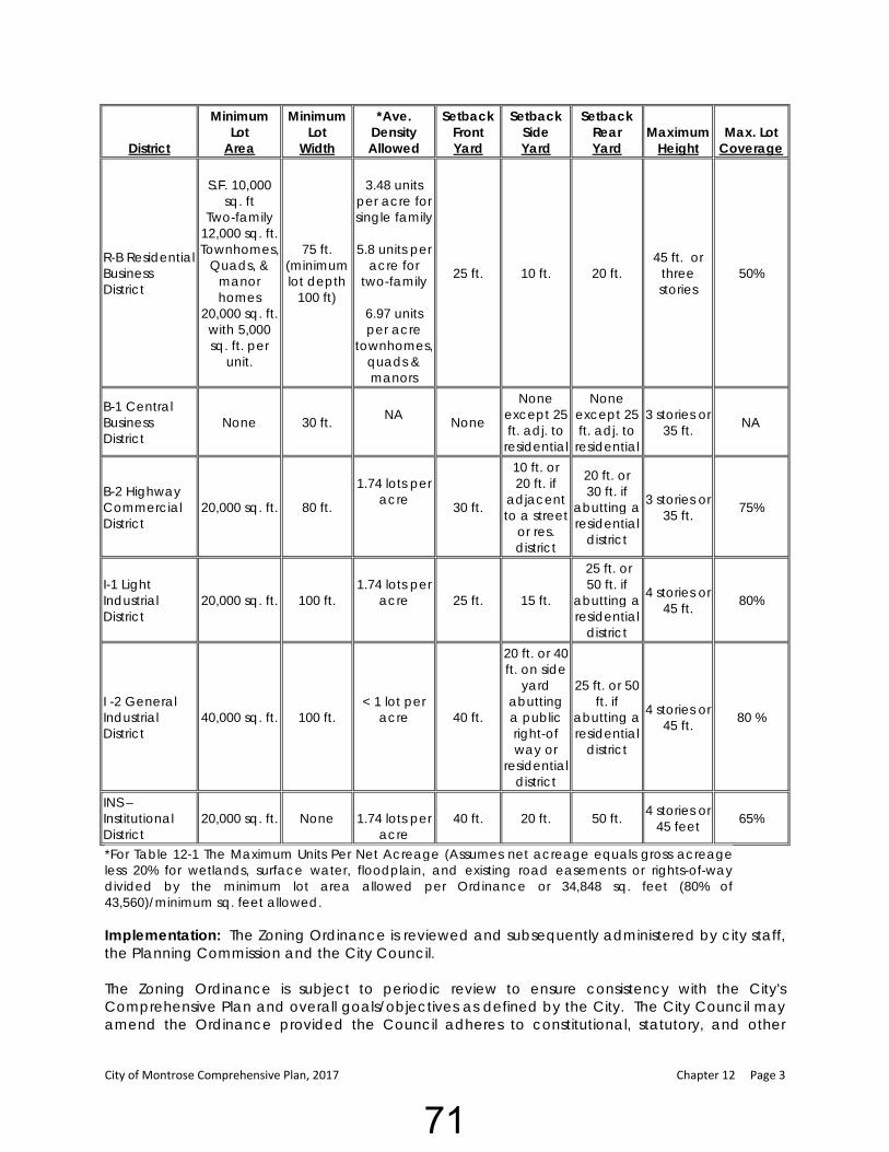
City of Montrose Comprehensive Plan, 2017 Chapter 12 Page 3
District
Minimum Lot
Area
Minimum Lot
Width
*Ave. Density Allowed
Setback Front Yard
Setback Side Yard
Setback Rear Yard
Maximum Height
Max. Lot Coverage
R-B Residential Business District
S.F. 10,000 sq. ft
Two-family 12,000 sq. ft. Townhomes,
Quads, & manor homes
20,000 sq. ft. with 5,000 sq. ft. per
unit.
75 ft. (minimum lot depth
100 ft)
3.48 units
per acre for single family
5.8 units per
acre for two-family
6.97 units per acre
townhomes, quads & manors
25 ft. 10 ft. 20 ft. 45 ft. or
three stories
50%
B-1 Central Business District
None 30 ft.
NA None
None except 25 ft. adj. to
residential
None except 25 ft. adj. to
residential
3 stories or 35 ft. NA
B-2 Highway Commercial District
20,000 sq. ft. 80 ft.
1.74 lots per
acre 30 ft.
10 ft. or 20 ft. if
adjacent to a street
or res. district
20 ft. or 30 ft. if
abutting a residential
district
3 stories or 35 ft. 75%
I-1 Light Industrial District
20,000 sq. ft. 100 ft.
1.74 lots per
acre
25 ft. 15 ft.
25 ft. or 50 ft. if
abutting a residential
district
4 stories or 45 ft. 80%
I -2 General Industrial District
40,000 sq. ft. 100 ft.
< 1 lot per acre 40 ft.
20 ft. or 40 ft. on side
yard abutting a public right-of way or
residential district
25 ft. or 50 ft. if
abutting a residential
district
4 stories or 45 ft. 80 %
INS – Institutional District
20,000 sq. ft. None
1.74 lots per acre
40 ft. 20 ft. 50 ft. 4 stories or 45 feet 65%
*For Table 12-1 The Maximum Units Per Net Acreage (Assumes net acreage equals gross acreage less 20% for wetlands, surface water, floodplain, and existing road easements or rights-of-way divided by the minimum lot area allowed per Ordinance or 34,848 sq. feet (80% of 43,560)/minimum sq. feet allowed. Implementation: The Zoning Ordinance is reviewed and subsequently administered by city staff, the Planning Commission and the City Council. The Zoning Ordinance is subject to periodic review to ensure consistency with the City's Comprehensive Plan and overall goals/objectives as defined by the City. The City Council may amend the Ordinance provided the Council adheres to constitutional, statutory, and other
71
City of Montrose Comprehensive Plan, 2017 Chapter 12 Page 4
lawful procedures. The City shall not approve zoning ordinance amendments which conflict with the current Comprehensive Plan. In order to ensure the Zoning Ordinance is consistent with the goals and objectives of this Comprehensive Plan, the Planning Commission and Council should, after approving the Comprehensive Plan, address the following zoning ordinance recommendations: Recommendations:
1. As the city continues to grow, the Planning Commission and EDA, per Chapter 5 of the Comprehensive Plan, are encouraged to work with businesses and landlords to implement Highway 12 Design Standards within the Zoning Ordinance for the Downtown and Highway Commercial Districts, in order to effectively implement the Highway 12 Redevelopment Plan.
2. Section 1066-7. The Planning Commission should review minimum lot size, lot width and maximum lot coverage regulations within the R-B district for commercial and public uses. The ordinance currently addresses lot sizes and setbacks for residential structures. While medical buildings, city offices, and nursing homes are permitted as a conditional use, lot sizes for those uses are not addressed.
3. To address the changing demographic and needs of aging individuals, it is
recommended the Planning Commission investigate options to serve this growing population through zoning provisions for senior housing or consider provisions to consider allowing accessory dwelling units in appropriate residential areas.
4. The City should rezone parcels identified in the Land Use Chapter, Chapter 11, to fit the
identified highest and best use.
5. Section 1065-9 B. allows a maximum height of two and one-half (2 ½ stories) or 45 feet in the R-4 High Density District. The R-3, Medium Density District and the R-B, residential Business Districts allow 45 feet or 3 ½ stories. Multiple family buildings are more likely to be three story structures. The 45-foot height corresponds with a 3 story. It is recommended Section 1065-9 B be amended to allow three story buildings.
6. To encourage sustainability and quality of life goals, it is recommended the Planning
Commission review the Zoning Ordinance as it relates to recommendations provided by Minnesota GreenStep Cities, including mixed uses, vertical mixed uses, etc.
III. SUBDIVISION ORDINANCE The City of Montrose Subdivision Ordinance regulates the division or platting of land within the City's corporate limits. Subdivision regulations address the layout and placement of a new lots, developments, roads, parks, trail utilities, etc. Subdivision regulations are a tool for guiding the design of new development and its coordination with existing development, and existing and planned public facilities and services. Purpose: As stated in the Subdivision Ordinance, “The City Council being aware of the responsibility which they have for the adoption of ordinances, rules and regulations designed for the protection of health, safety and general welfare of this community, deems it necessary to provide regulations for the subdividing of property within the City. Each new subdivision shall
72
City of Montrose Comprehensive Plan, 2017 Chapter 12 Page 5
become a permanent neighborhood in the community. Piecemeal planning of subdivisions, without correlation to the Comprehensive Plan, can bring a disconnected patchwork of plats, poor circulation, and an undesirable atmosphere…” 2 To accomplish this, the Subdivision Ordinance includes several sections, as follows: Contents: The Subdivision Ordinance includes the following Sections:
Title and Application Rules and Definitions Administrative Subdivisions Concept Plan, Preliminary Plats and Final Plats Design Standards Enforcement; and Severability, Supremacy and Effective Date.
Implementation: The Subdivision Ordinance is subject to periodic review to ensure consistency with the City's Comprehensive Plan and overall goals/objectives as defined by the City. The City Council may amend the Ordinance provided the Council adheres to constitutional, statutory and other lawful procedures. The City shall not approve Subdivision Ordinance amendments which conflict with the current Comprehensive Plan. In order to ensure the Subdivision Ordinance is consistent with the goals and objectives of this Comprehensive Plan, the Planning Commission and Council, after approving the Comprehensive Plan, should address the following: Recommendations:
1. Section 1107.13 Public Site and Open Spaces (Park Land Dedication). The Planning
Commission and City Council should review park dedication standards to assure they are adequately addressing the needs of the park system through developer dedication. When subdivisions occur in areas in which “park search areas” have been identified, on Map 6-3, the City is encouraged to obtain land versus a fee-in-lieu of payment.
2. The Planning Commission should review the Subdivision Ordinance as it relates to recommendations provided by Minnesota GreenStep Cities, including street design, parks and trails, etc., to encourage sustainability and quality-of-life goals.
IV. CAPITAL IMPROVEMENT PLAN The long-range capital improvements program (“CIP”) is a five (5) year plan that prioritizes and directs city funding for appropriate projects including streets, utilities, trails, parks, trails, municipal buildings, etc. The CIP includes a financing plan for multi-year projects and a schedule for high priority projects. A key component of the CIP is a one-year adopted capital improvement budget. The CIP may identify a mix of local funds, grants, private and other public funding sources for the capital improvement projects. The overall objective of the Capital Improvement Plan (CIP) is to provide for the efficient use of fiscal resources in funding future capital expenses. The CIP should be a flexible, evolving tool the City uses as a guide for the future. The annual CIP update should allow for capital necessity and prioritization changes. Along with anticipated expenditures, the CIP should include proposed 2 Montrose Subdivision Ordinance, Chapter 11
73
City of Montrose Comprehensive Plan, 2017 Chapter 12 Page 6
sources of funding such as special assessments, enterprise funds (water, sanitary sewer, and storm sewer), state aid, annual levy, etc. Expenditures for water, sewer, transportation (street/sidewalk/trail), equipment purchases and public facilities are included. The phasing in of projects which require the same sources of funds assists in retaining a level annual tax levy. A CIP is an important implementation tool to ensure that Montrose has planned the most cost-effective facilities and to determine whether the government will have the capability to fund needed public facilities and services. The long-range CIP should reflect the size, approximate location and estimated costs of improvements needed to serve anticipated growth for the next fifteen to twenty years. This plan is not a detailed engineering document, but it should provide enough specificity to determine which costs are required to remedy existing deficiencies and which costs provide new capacity that will be demanded by new development. Montrose staff, officials and public should participate in the annual review and update of the CIP. The City Council will ultimately determine the five-year CIP and the annual capital improvement plan budget. Recommendations:
1. The Capital Improvement Plan should continue to be updated and include street projects anticipated to be completed within the next five years including, but not limited to Centre Avenue, US TH 12, CR 12 and the widening of the right-of-way (sidewalk area) within the designated “downtown” area.
2. The City should continually analyze Water and Sewer Access Charges and user fees and adjust rates to ensure capital expenditures identified in the CIP can be funded.
3. The Capital Improvement Plan should be expanded to address future public facilities needs including fire hall, community center and city hall improvement projects.
4. The City Council should consider including the implementation of the Downtown
Streetscape Plan, including decorative streetlights, trees and landscaping, and signage in the Capital Improvement Plan, and explore funding sources to assist with the project.
V. GROWTH AREAS AND ANNEXATION The City of Montrose, through its comprehensive planning process, has identified land use needs to accommodate additional residential, commercial and industrial development both within the existing corporate limits as well as in potential annexation areas. The interim growth boundary identified within the AUAR is anticipated to meet the needs of the city to the year 2040 and beyond. Parcels within the interim growth boundary, which are currently in the townships, are to be annexed into the City of Montrose prior to being developed. The City has orderly annexation agreements in place to address the timing and process for annexation.
VI. COMPREHENSIVE PLAN REVIEW AND REVISION The Comprehensive Plan is intended to guide the growth of the community. As events and circumstances within the community change, the Comprehensive Plan shall be reviewed and updated, as appropriate. Amendments to the Comprehensive Plan shall not occur without public notice, a public hearing conducted by the Planning Commission and final approval by
74
City of Montrose Comprehensive Plan, 2017 Chapter 12 Page 7
the City Council. Amendments to the Comprehensive Plan should be considered if there have been changes within the community or issues arise which were not anticipated by the Plan. Recommendations:
1. It is recommended the Planning Commission and City Council review and update the Comprehensive Plan at five to ten year intervals to ensure it is a current reflection of the city’s growth patterns, community goals and land use needs.
2. The Comprehensive Plan may be amended upon petition from the public, initiation by
the Planning Commission or direction from the City Council. No amendment shall be adopted until a public hearing has been conducted by the Planning Commission with recommendation to the City Council. A 2/3 affirmative vote of the City Council is required to amend the Plan.
3. It is recommended that the City Clerk periodically report to the Planning Commission and
City Council (re)development issues which have occurred as they relate to the Comprehensive Plan, proposed projects which have an impact on the accuracy on the Plan projections, and a list of implementation goals identified within the Plan and the status of implementation.
75