monitoring and reporting framework · monitoring and reporting framework melbourne strategic...
TRANSCRIPT
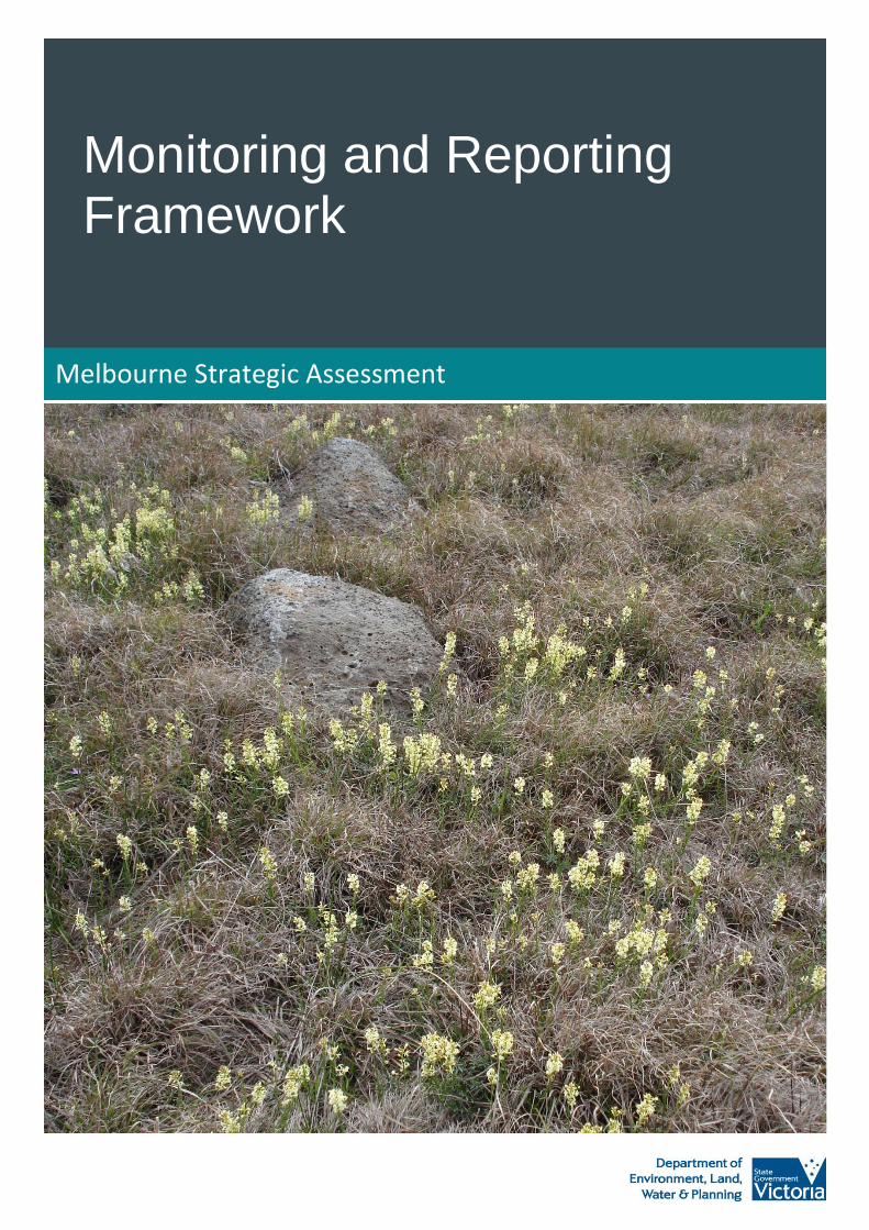
Monitoring and Reporting Framework
Melbourne Strategic Assessment

© The State of Victoria Department of Environment, Land, Water and Planning 2015
This work is licensed under a Creative Commons Attribution 3.0 Australia licence. You are free to re-use the work under that licence, on the
condition that you credit the State of Victoria as author. The licence does not apply to any images, photographs or branding, including the Victorian
Coat of Arms, the Victorian Government logo and the Department of Environment, Land, Water and Planning logo. To view a copy of this licence,
visit http://creativecommons.org/licenses/by/3.0/au/deed.en
ISBN 978-1-74146-575-4
Accessibility
If you would like to receive this publication in an alternative format, please telephone the DELWP Customer Service Centre on 136186, email
[email protected] , or via the National Relay Service on 133 677 www.relayservice.com.au. This document is also available on the
internet at www.delwp.vic.gov.au
Disclaimer
This publication may be of assistance to you but the State of Victoria and its employees do not guarantee that the publication is without flaw of any kind or is wholly appropriate for your particular purposes and therefore disclaims all liability for any error, loss or other consequence which may arise from you relying on any information in this publication.
Monitoring and Reporting Framework Melbourne Strategic Assessment 2
Contents
Introduction 4
Purpose and scope of the Monitoring and Reporting Framework 5
Components of the Monitoring and Reporting Framework 6
Adaptive management 8
Monitoring design principles 8
Statistical power 9
The Melbourne Strategic Asessment (MSA) Program 10
Program logic 10
Program assumptions and external factors 11
Program activities and processes 13
Monitoring and reporting 13
Program outputs 15
Key performance indicators 16
Monitoring 16
Reporting 17
Evaluation of program implementation 17
Program Outcomes 19
Key performance indicators 19
Monitoring 19
Reporting 20
Evaluation of program impact 20
Roles and responsibilities 22
Timelines 23
Review 24
Appendix 1: Program Logic 25
Appendix 2: Key Performance Indicators for Program Outputs 26
Key performance indicators for the outputs that the Melbourne Strategic Assessment expects to achieve 26
Appendix 3: Key Performance Indicators for Program Outcomes 36

Monitoring and Reporting Framework Melbourne Strategic Assessment 3
Key performance indicators for the outcomes that the Melbourne Strategic Assessment expects to achieve 36
Appendix 3: Key Performance Indicators for Broader Outcomes 39
Key performance indicators for the broader outcomes that the Melbourne Strategic Assessment will contribute to 39
List of figures
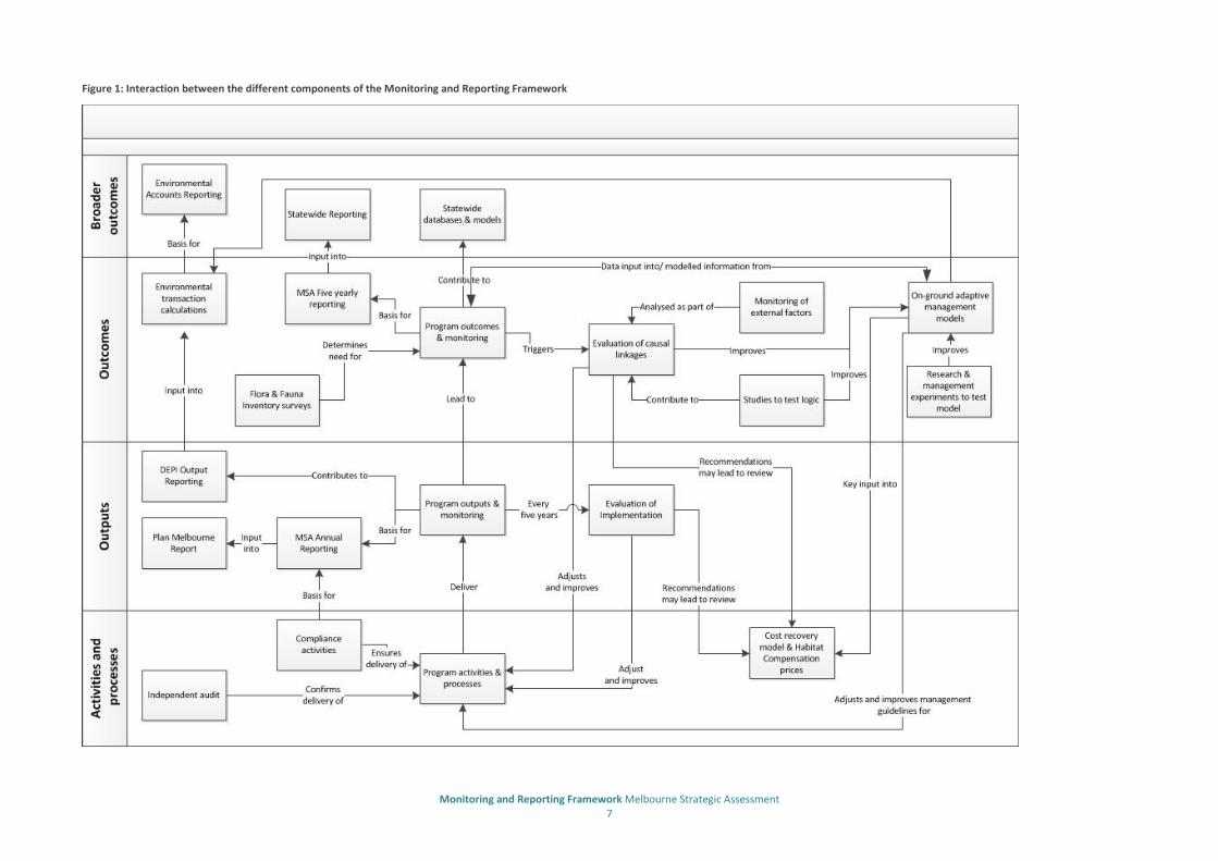
Figure 1: Interaction between the different components of the Monitoring and Reporting Framework 7
List of tables
Table 1: Program logic outline 10
Table 2: Program assumptions 11
Table 3: External factors relevant to the program 12
Table 4: Key evaluation questions for an evaluation of implementation 17
Table 5: Key evaluation questions for an evaluation to determine cause and effect relationships 20
Table 6: Roles of other public authorities in implementing the MRF 22
Table 7: Timeframes for monitoring and reporting 23
Monitoring and Reporting Framework Melbourne Strategic Assessment 4
Introduction
The Melbourne Strategic Assessment (MSA) evaluates the impacts of the Victorian Government’s urban development program for Melbourne on matters of national environmental significance (MNES) listed under the Commonwealth Environment Protection and Biodiversity Conservation Act 1999 (EPBC Act) and establishes conservation measures to mitigate these impacts. The MSA was conducted under the strategic assessment provisions of the EPBC Act.
The government’s urban development program for Melbourne provides for:
Urban development in four growth corridors within Melbourne’s expanded 2010 Urban Growth Boundary (UGB)
Urban development in 28 existing precincts within the 2005 UGB
Development of the Regional Rail Link Corridor between west of Werribee and Deer Park (section 2)
Development of the Outer Metropolitan Ring Transport Corridor.
The strategic approach to environmental assessment undertaken through the MSA results in improved biodiversity outcomes for MNES by enabling earlier consideration of environmental matters in planning processes, better assessment of the cumulative impacts of developments and more strategic conservation measures.
The Victorian Government made commitments to the Commonwealth Government in relation to conservation measures, or program outputs, and program outcomes required to protect MNES. These are outlined in Delivering Melbourne’s Newest Sustainable Communities: Program Report (Victorian Government, 2009).
The Commonwealth Environment Minister endorsed the program, as set out in the Program Report, in February 2010. The Commonwealth Minister subsequently approved the Regional Rail Link and urban development in the 28 existing urban precincts in July 2010 and urban development in three of the four growth corridors in September 2013.
The program outputs to be achieved as part of the MSA are:
Urban and infrastructure development occurs in accordance with the Commonwealth approvals
Program cost recovery is transparent and efficient
A 15,000 hectare grassland reserve is established and managed
A network of conservation areas within the UGB is protected and managed for MNES species and vegetation communities
A 1,200 hectare Grassy Eucalypt Woodland reserve is established and managed outside the UGB
80 per cent of Grassy Eucalypt Woodland within the UGB is protected and managed
80 per cent of highest priority habitats for Golden Sun Moth, Spiny Rice-flower and Matted Flax-lily are protected and managed
Important landscape and habitat areas for Southern Brown Bandicoot are protected and managed.
The program outputs and program outcomes are designed to mitigate the impacts of urban development associated with the program on matters of national environmental significance and state significance. The Victorian Government is responsible for ensuring the program outputs and outcomes effectively mitigate these impacts, including through adaptive implementation of the program where necessary.
The program is subject to a range of external factors outside the scope and control of the program that may influence the ability to successfully deliver the program outputs and outcomes. Examples of these external
Monitoring and Reporting Framework Melbourne Strategic Assessment 5
factors are provided in Table 3. The Victorian Government cannot assume responsibility for the mitigation of impacts that are not associated with urban development and are outside the scope and control of the program.
The Department of Environment, Land, Water and Planning (DELWP) established a cost recovery model to fund the implementation of the program. The model establishes the habitat compensation fees to be collected from landowners who remove native vegetation and habitat for MNES within the growth corridors. Approximately $986 million will be collected under the model over a 30 to 40 year period to fund the program.
The Victorian Government committed to preparing a Monitoring and Reporting Framework (MRF) for the MSA program to ensure compliance with the endorsed program and the conditions of the Commonwealth approvals. The MRF provides the framework for monitoring and reporting on progress in achieving the program outputs and outcomes. Consistent with the program report, the MRF provides for an adaptive management approach to enable improvements to the implementation of the program to be made where necessary to ensure the outputs and outcomes are achieved.
The MRF was prepared by DELWP in consultation with the Commonwealth Department of Environment (DoE), the Victorian Department of Economic Development, Jobs, Transport and Resources (DEDJTR) and the Metropolitan Planning Authority (MPA).
The MRF applies to the following areas:
The area covered by the MSA program within the UGB
The conservation areas to be established outside the UGB, including the Western Grassland Reserves, Grassy Eucalypt Woodland Reserve and conservation areas on the Victorian Volcanic Plain
The management area identified in the Sub-regional Species Strategy for the Southern Brown Bandicoot.
Purpose and scope of the Monitoring and Reporting Framework
The purpose of the MRF is to assist the Victorian Government to:
Provide transparency in the implementation of the program
Determine whether the conservation outcomes for MNES set out in the program report are being achieved
Determine whether the processes and activities established to achieve the program outputs and program outcomes are efficient and effective
Adaptively improve the implementation of the program where necessary to ensure the program outputs and program outcomes are achieved.
The MRF sets outs how the Victorian Government will monitor and report on activities, processes, program outputs and program outcomes established to deliver and implement the MSA. It does not cover activities and processes that are required under existing legislative obligations, policies or practices and that would have occurred irrespective of the MSA. These activities and processes are monitored and reported through existing arrangements.

Monitoring and Reporting Framework Melbourne Strategic Assessment 6
Components of the Monitoring and Reporting Framework
The key components of the MRF are:
Program logic – This describes the relationships between program activities and processes, program outputs and program outcomes and how activities are expected to lead to outcomes. It provides a framework for determining program assumptions, key evaluation questions and key performance indicators (KPIs)
KPIs – These have been developed for program outputs and program outcomes and will be used to measure progress against the achievement of the outputs and outcomes. In some cases multiple KPIs have been developed to provide a better understanding of the progress against the outcome
Monitoring protocols – These have been developed for each KPI and set out how monitoring will be undertaken, including where monitoring will occur, the types of data to be collected and the frequency of data collection
Reporting – Templates have been developed for program outputs and program outcomes and set out the matters that will be reported annually or five yearly against each output and outcome. These are also described in the Technical Protocols
Evaluations – Two types of evaluations will be undertaken as part of the MRF:
o An evaluation of program implementation. This will be undertaken every 5 years to ensure that the program is being delivered efficiently and effectively
o An evaluation of program impact. This will be undertaken subject to a review of the results of the monitoring of program outcomes every five years
o Program evaluations will inform any necessary adaptive improvements to the implementation of the program
Independent Auditor – Auditors will be engaged in two phases during the first 10 years of the implementation of the program to audit compliance of the implementation of stages 2 and 3 with the endorsed program
Compliance Strategy – This document is to ensure that landowners and proponents undertake actions, such as urban and infrastructure development, in accordance with the program approvals and the planning mechanisms and processes established to implement the program and to ensure that the conservation areas established as part of the MSA are not degraded prior to being secured for conservation.
The components of the MRF are described in more detail in the following sections of this document.
Figure 1 provides a conceptual map of how the components of the MRF interact and relate to other program activities.
The MRF is supported by the following documents:
Monitoring and Reporting Framework: Technical Protocols for Program Outputs – This document outlines the KPIs for program outputs and describes the monitoring protocols that will be used for the collection of data
Monitoring and Reporting Framework: Technical Protocols for Program Outcomes – This document outlines the KPIs for measuring progress against the program outcomes, as well as other data collection requirements. It provides details of monitoring protocols and effort.
Monitoring and Reporting Framework Melbourne Strategic Assessment 7
Figure 1: Interaction between the different components of the Monitoring and Reporting Framework
Monitoring and Reporting Framework Melbourne Strategic Assessment 8
Adaptive management
Adaptive management refers to a program of monitoring and management that is adjusted over time as understanding of management improves. The MRF provides for the following key elements of an adaptive management approach (see Figure 1):
Defining desired outcomes
Addressing uncertainties through identification and where appropriate, testing of assumptions and external factors
Establishing a program of monitoring to record changes in the condition or population of MNES and track progress in program delivery
Undertaking research and management experiments to test and improve management models (the on-ground adaptive management models for ecological communities) and inform management options
Re-assessing solutions and approaches through program evaluations.
The results of monitoring and program evaluations may lead to the adaptive improvement of the implementation of the program. This may occur through the following:
Changes to program activities and processes, such as planning mechanisms, strategies and policies, research priorities, on-ground management actions, restoration activities and salvage and translocation priorities
Amendments to the Biodiversity Conservation Strategy (BCS) and sub-regional species strategies
Improvements to the logic underpinning the on-ground adaptive management models
Changes to management standards and guidelines for conservation areas
Amendments to program outputs and outcomes, with the agreement of the Commonwealth Government.
The MRF does not cover all aspects of on-ground adaptive management of land. These aspects will be addressed by undertaking additional work to detail management options for each asset and/or location.
Monitoring design principles
The monitoring described in the MRF and two supporting technical documents is guided by the following principles:
Monitoring is driven by well-defined ‘questions’ that are specific, measurable and time-bound (Park et al. 2012)
Monitoring is informed by defined conceptual models, wherever possible (e.g. on-ground adaptive management models for ecological communities, a metapopulation model for the Growling Grass Frog)
Monitoring provides the necessary information by which the program outcomes can be evaluated against KPIs
Monitoring is underpinned by rigorous statistical design, using the best available information
Monitoring links to the adaptive management cycle (Lindenmayer and Likens 2009)
Monitoring will be periodically reviewed to reflect advances in ecological understanding or improved sampling
Monitoring will be efficient and cost effective.
Monitoring and Reporting Framework Melbourne Strategic Assessment 9
Statistical power
It is good practice to undertake ‘power analysis’ in the design phase of an ecological monitoring program to determine the minimum sample size that should be adequate to detect a change or effect of a given size (Lawrence 1985; Legg and Nagy 2006). The appropriate sample size for monitoring an ecological asset depends on the variation in the data and the statistical test that is used (the type of test and degree of statistical significance applied).
The sample sizes for the monitoring of program outcomes are set out in Monitoring and Reporting Framework: Technical Protocols for Program Outcomes. These were estimated in a precautionary manner, using previous studies of similar parameters in similar (i.e. grassy) systems as a qualitative and informal guide to sample size. Early data collection will serve as a pilot study to determine the variance in each variable in each ‘state’ in each community, and the sampling effort may be adjusted as necessary as part of a review of the MRF.
Monitoring and Reporting Framework Melbourne Strategic Assessment 10
The Melbourne Strategic Assessment (MSA) Program
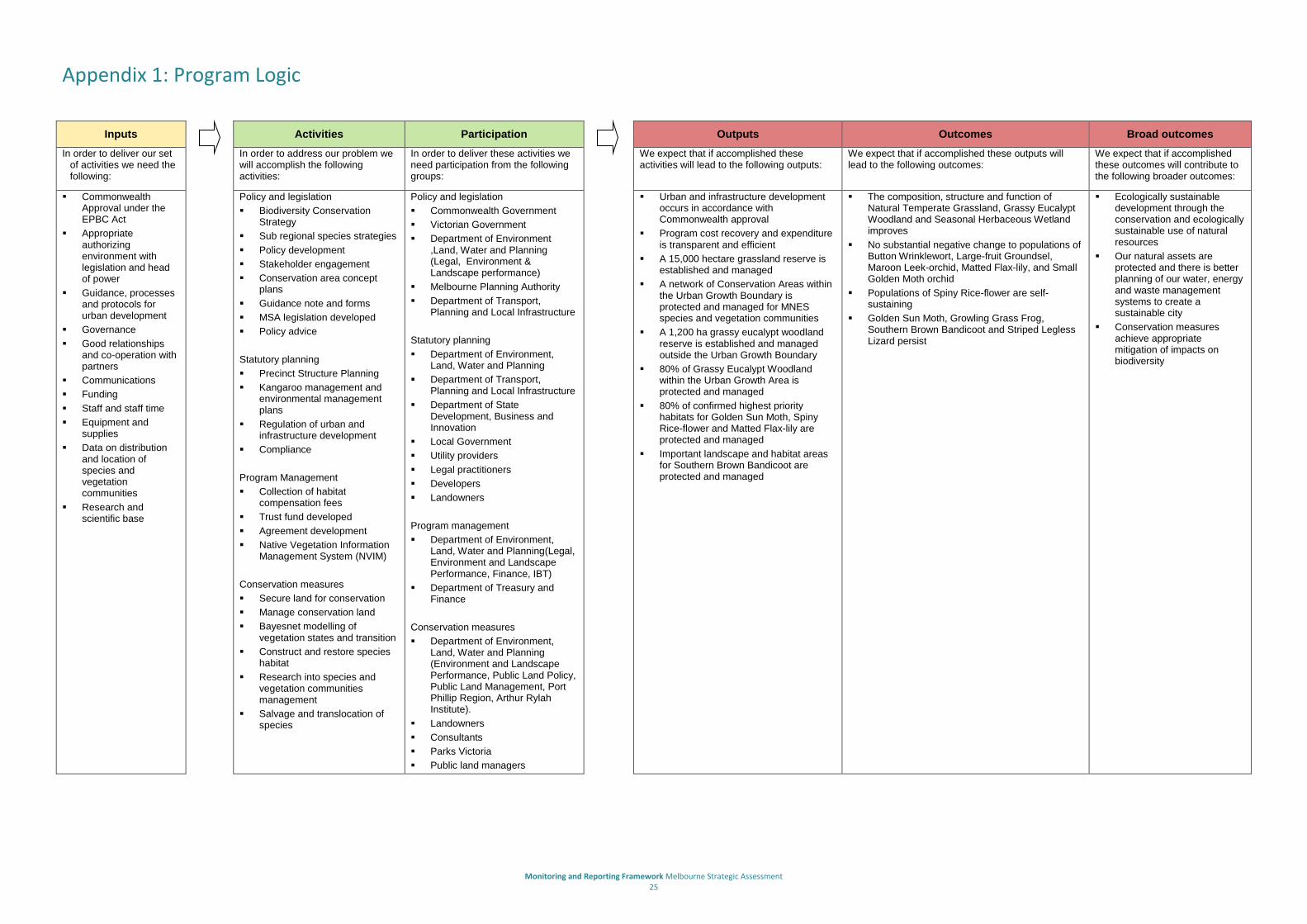
Program logic
DELWP has developed a program logic for the MSA program that describes the overall relationships between program activities and processes, outputs and outcomes and how activities are expected to lead to outcomes.
The program logic is provided in Appendix 1.
The purpose of the program logic is to provide a framework for:
Determining assumptions underpinning the program
Determining key evaluation questions and key performance indicators
Undertaking program evaluations and informing adaptive improvements to the implementation of the program
Communicating with key stakeholders about the program.
The program logic includes a number of outcomes:
The composition, structure and function of Natural Temperate Grassland, Grassy Eucalypt Woodland and Seasonal Herbaceous Wetland improves
No substantial negative change to populations of Button Wrinklewort, Large-fruit Groundsel, Maroon Leek-orchid, Matted Flax-lily, and Small Golden Moth orchid
There is no substantial negative change to populations of Spiny Rice-flower and populations are self-sustaining
Golden Sun Moth, Growling Grass Frog, Southern Brown Bandicoot and Striped Legless Lizard persist.
These will be achieved through the implementation of program outputs, including planning mechanisms and processes associated with urban and infrastructure development and the protection and management of grassland and grassy eucalypt woodland reserves outside the UGB and a network of 36 conservation areas within the UGB.
A summary of the key elements of the program logic, together with examples from the MSA is provided in Table 1.
Table 1: Program logic outline
Program Logic Definition Example
Broader outcomes Measurable contribution of delivering the outcomes to a long term statewide or nationwide objective
Our natural assets are protected and there is better planning of our water, energy and waste management systems to create a sustainable city
Program outcomes Measurable impact of delivering the outputs leading to a change in status of an MNES within the program
The composition, structure and function of Natural Temperate Grassland improves
Program outputs Direct results of the activities A network of Conservation Areas within the Urban Growth Boundary is protected and managed for MNES species and vegetation communities

Monitoring and Reporting Framework Melbourne Strategic Assessment 11
Program Logic Definition Example
Activities and processes Processes, actions, products and events of the program
Precinct Structure Planning, land acquisition
Inputs Materials, equipment, resources, legislation, etc. used to deliver the outputs
Funding, staff resources, time, contractors
Program assumptions and external factors
The program logic and achievement of the program outcomes are underpinned by a number of assumptions which are provided in Table 2. The program assumptions have informed the identification of program risks and will form the basis for testing the program logic, undertaking program evaluations and adaptively improving the implementation of the program. In some cases, additional data may be collected as part of program evaluations to test the program assumptions.
Table 2: Program assumptions
MSA program assumptions
There is sufficient knowledge of species and vegetation communities to enable effective design of the urban growth area
The conservation measures proposed will mitigate the impact of urban development on MNES
The outcomes are not mutually exclusive. Occasionally the management of one species may conflict with management of another, however it is assumed that the conflict does not jeopardise the outcomes for either species overall
The Conservation Area network is sufficiently large and appropriately arranged (including across multiple tenures), such that it is able to support populations of the relevant species that fulfil the outcomes
Demographic extinction debts do not make extinction of the relevant species certain
Land management before protection does not remove or degrade the assets to the extent that the outcomes cannot be achieved
Management actions are available or possible which achieve the outcomes, without incurring unacceptable costs or risks (e.g. fire risk, excessive dollar costs)
Hydrological changes are managed such that sufficient wetland and floodplain habitat remains viable for the outcomes to be met
The program is subject to a range of external factors outside the scope and control of the program that may influence the ability to successfully deliver the program outputs and outcomes.
Examples of external factors relevant to the program are provided in Table 3.
The Victorian Government is responsible for ensuring the program outputs and outcomes effectively mitigate the impacts of urban development associated with the program on matters of national environmental significance and state significance, including through adaptive implementation of the program where necessary.
The Victorian Government cannot assume responsibility for the mitigation of impacts that are not associated with urban development and are outside the scope and control of the program.
External factors will be considered in program evaluations where monitoring indicates that program activities and processes and program outputs are not achieving the program outcomes. In some cases, additional data may be collected as part of program evaluations to assist in understanding the cause of any unexpected changes.

Monitoring and Reporting Framework Melbourne Strategic Assessment 12
Table 3: External factors relevant to the program
External factors
The global financial economy and its impact on the Melbourne housing market may delay development thereby increasing the time until conservation areas are secured
Existing isolation of species populations, fragmentation and legacy issues resulting from past clearing and land use may affect the management and long term viability of species and habitat
Large scale ecological processes that are necessary to the outcomes may be jeopardised across the wider area (e.g. insect pollination, dispersal of mobile species)
Stochastic events such as fire, pest outbreak, etc. may impact on biodiversity values
The effects of climate change may result in loss of viable habitat for the relevant species to an extent that the outcomes cannot be achieved.
Monitoring and Reporting Framework Melbourne Strategic Assessment 13
Program activities and processes
The Victorian Government will undertake a range of activities and processes to support the delivery of the program outputs and outcomes. The program report identifies that these will be implemented in four key stages:
Stage 1 (program approval) – This stage is complete and involved gaining approvals of the program. These approvals specified conditions for implementation of the remaining three stages of the program
Stage 2 (process implementation) – This stage involves the establishment of planning mechanisms and processes to implement the program, such as Growth Corridor Plans, conservation strategies, Precinct Structure Plans, Native Vegetation Precinct Plans, management plans, planning permits and the reservation of land for transport corridors and the Western Grassland Reserves
Stage 3 (construction and works) – This stage involves the construction of urban areas and transport infrastructure to implement the program in accordance with the planning mechanisms and processes established in stage 2 and approvals granted in stage 1
Stage 4 (operation) – This stage involves the operation and use of the land developed under the program, including urban activity, use of transport infrastructure and management of the conservation areas.
Monitoring and reporting
Monitoring and reporting of program activities and processes will occur through two main mechanisms, described more fully below; the Independent monitor and compliance strategy for the MSA program.
Independent monitor
The Victorian Government will engage auditors in two phases during the first 10 years of the implementation of the program. The role of the auditors is to:
Audit compliance of the implementation of stages 2 and 3 with the endorsed Program
Provide reasonable assurance to the Commonwealth Government that the Program is being implemented in accordance with the Program Report.
In stage 2, an auditor will be engaged to review the establishment of the planning mechanisms and processes to implement the program, such as Growth Corridor Plans, Precinct Structure Plans, and conservation strategies, against the requirements of the program report. This stage of the program will be audited in 2014 and in 2016.
In stage 3, an auditor will be engaged to review the construction of urban areas and transport infrastructure to implement the program against the requirements of the planning mechanisms and processes established in stage 2 and program approvals granted in stage 1. This stage of the program will be audited in 2017 and 2022.
The auditors will prepare reports on the results of the audits of stages 2 and 3 for the Victorian Government. The reports will identify any non-compliance, identify where any amendments to activities and processes were agreed between the Commonwealth Government and Victorian Government, and make recommendations to rectify any non-compliance.
The reports will be provided to the Commonwealth Government and publicly released.

Monitoring and Reporting Framework Melbourne Strategic Assessment 14
Compliance strategy
DELWP will prepare a compliance strategy for the MSA program in consultation with MPA, DEDJTR and the Commonwealth Government. The purpose of the compliance strategy is to ensure that landowners and proponents undertake actions, such as urban and infrastructure development, in accordance with the program approvals and planning mechanisms and processes and that non-permitted actions do not occur both within and outside the conservation areas.
The compliance strategy will set out:
The types of processes and activities that will be targeted for compliance
How compliance activities will be undertaken
Roles and responsibilities of different government authorities in undertaking compliance
Procedures for taking any action against non-compliance.
The results of compliance activities will be reported annually as part of the reporting on program outputs.
Monitoring and Reporting Framework Melbourne Strategic Assessment 15
Public Reporting
The Program Report (Delivering Melbourne’s Newest Sustainable Communities) commits to public reporting to assist transparency and public accountability. Monitoring under the Monitoring and Reporting Framework will be divided into two documents released at regular intervals to the public;
Melbourne Strategic Asssessment: Output Progress Report- This document will outline the progress against KPIs for program outputs and will be released annually for the previous year
Melbourne Strategic Assessment: Outcome Progress Report- This document will outline the progress against KPIs for program outcomes and will be released every five years for the previous five years.
Progress reports will be available to the public via the DELWP website. All documents will be published in accordance with the Victorian Government’s accessibility requirements and will remain available for the life of the program.
Monitoring and Reporting Framework Melbourne Strategic Assessment 16
Program outputs
Implementation of the program activities and processes are expected to lead to the delivery of eight program outputs:
Urban and infrastructure development occurs in accordance with the Commonwealth approvals
Program cost recovery and expenditure is transparent and efficient
A 15,000 hectare grassland reserve is established and managed
A network of conservation areas within the UGB is protected and managed for MNES species and vegetation communities
A 1,200 hectare Grassy Eucalypt Woodland reserve is established and managed outside the UGB
80% of Grassy Eucalypt Woodland within the Urban Growth Boundary is protected and managed
80% of confirmed highest priority habitat for Golden Sun Moth, Spiny Rice-flower and Matted Flax-lily are protected and managed
Important landscape and habitat areas for Southern Brown Bandicoot are protected and managed.
Key performance indicators
KPIs have been established and described for each program output.
The KPIs are set out in Monitoring and Reporting Framework: Technical Protocols for Program Outputs, and are summarised in Appendix 2.
Monitoring
Monitoring of the KPIs will be undertaken in accordance with the specifications in Monitoring and Reporting Framework: Technical Protocols for Program Outputs. This document sets out the types of monitoring activities that will occur, the types of data collected, the source of the data, the frequency of data collection, monitoring protocols, and responsibilities.
The key types of data that will be collected to monitor the program output KPIs are:
Data from audits of samples of permits and other planning mechanisms from each local government area
Data from contracts, land purchase forms, land security agreements, habitat compensation statements, land manager reports, native vegetation mapping, secondary approvals and third party notifications.
The collection of data will be undertaken on an annual basis.
DELWP will be primarily responsible for the collection of data. Other government authorities, such as local councils, will be responsible for collating and providing some data to DELWP on a regular basis.
The results of monitoring will be used to inform program evaluations for ‘program implementation’ and ‘program impact’.

Monitoring and Reporting Framework Melbourne Strategic Assessment 17
Reporting
Reporting on the monitoring of the program output KPIs will be undertaken on an annual basis in accordance with the reporting template in Monitoring and Reporting Framework: Technical Protocols for Program Outputs.
The reporting template requires reporting on the progress of the delivery of each KPI for the current reporting period and the overall progress of the delivery of each KPI to date where relevant.
DELWP will be responsible for preparing the annual progress reports. The reports will be provided to the Commonwealth Government and made available to the public via the DELWP webite.
Evaluation of program implementation
In order to ensure that the program is being delivered efficiently and effectively, the Victorian Government will undertake an evaluation of program implementation every five years. The first evaluation will occur in 2015.
The key evaluation questions that will form the basis for the evaluation are provided in Table 4.
The evaluation will aim to:
Determine the effectiveness of program activities and processes to deliver program outputs
Test assumptions made as part of the program logic
Inform a review of the habitat compensation cost recovery model and prices
Inform any necessary adaptive improvements to the implementation of the program.
The evaluation may lead to:
Changes to program activities and processes, such as planning mechanisms, strategies and policies
Amendments to the BCS and sub-regional species strategies, as part of the reviews of these strategies
Changes to or development of new guidance and communications materials.
A report on the results of the evaluation and any recommendations for adaptively improving the implementation of the program will be prepared and publicly released.
Table 4: Key evaluation questions for an evaluation of implementation
Category Key evaluation questions
Justification/problem Who benefits and how?
How have environmental, economic and legislative conditions changed?
Why does the program continue to be the best way to respond to the problem? Is the program supported by the stakeholders?
Effectiveness What is the evidence of the program’s progress towards its expected outcomes?
What evidence is there that planned activities and outputs have been achieved?
Have any unanticipated positive or negative outcomes occurred?
Are the processes, strategies and activities the best way to achieve the objectives and outcomes of the program? What activities contribute most? Least?
Is the program consistent with relevant best practice processes?
Funding/delivery What delivery methods are used? Who carries them out and how well do they do so?

Monitoring and Reporting Framework Melbourne Strategic Assessment 18
Category Key evaluation questions
Has the program been delivered within its scope, budget, within the expected timeframe, and in line with appropriate governance and risk management practices?
Risk What would be the impact of ceasing the program (for example, service impact, jobs, community) and what strategies have been identified to minimise negative impacts?
Efficiency Has the department demonstrated efficiency and economy in relation to the delivery of the program?
Could the program or any components of the program be implemented more efficiently and achieve higher value through alternative delivery/ service provider mechanisms?
How efficiently are stakeholder and department resources being used?
What could be done differently to improve implementation of the program?
Program design Is the program logic still valid? Is the treatment/outcome logic valid?
Are the relationships and assumptions in the program logic linking outputs to outcomes valid?
Are the KPIs and monitoring protocols still appropriate?

Monitoring and Reporting Framework Melbourne Strategic Assessment 19
Program Outcomes
Delivery of the program outputs are expected to lead to the delivery of the following program outcomes:
The composition, structure and function of Natural Temperate Grassland, Grassy Eucalypt Woodland and Seasonal Herbaceous Wetland improves
There is no substantial negative change to populations of Button Wrinklewort, Large-fruit Groundsel, Maroon Leek-orchid, Matted Flax-lily and Small Golden Moth Orchid
There is no substantial negative change to populations of Spiny Rice-flower and populations are self-sustaining
Golden Sun Moth, Growling Grass Frog, Southern Brown Bandicoot and Striped Legless Lizard persist.
Key performance indicators
KPIs have been established and described for each program outcome.
Additional data requirements have also been determined for each program outcome that will be used to support on-ground adaptive management and assist in determining cause and effect relationships, including the role of any external factors outside the control of the program that may influence the ability to achieve the program outcomes.
The KPIs are set out in Monitoring and Reporting Framework: Technical Protocols for Program Outcomes, and are summarised in Appendix 3.
Monitoring
Monitoring of the KPIs will be undertaken in accordance with the specifications in Monitoring and Reporting Framework: Technical Protocols for Program Outcomes. This document sets out the types of monitoring activities that will occur, where monitoring will occur, the types of data collected, data sources (storage), the frequency of data collection and monitoring protocols.
The key types of data that will be collected to monitor the program outcome KPIs are:
Full or partial counts of the number of individuals of a species in a defined area
Presence/absence of a species in a defined area over a defined level of search effort
Quality (or condition) of an ecological community, measured, for example, by the abundance of weeds, abundance of excess soil nutrients or distribution of sites among ‘states’ in a defined ‘state-transition’ model
The heterogeneity in structure of an ecological community across space, measured by the proportion of area in different structural categories.
Monitoring of relevant conservation areas will be progressive as the conservation areas are secured for conservation. The collection of data will generally be undertaken on an annual basis.
DELWP will be primarily responsible for the collection of data.
The results of monitoring will be used to inform program evaluations for ‘program impact’, as well as inform amendments to the on-ground adaptive management models.

Monitoring and Reporting Framework Melbourne Strategic Assessment 20
Reporting
Reporting on the monitoring of the program outcome KPIs will be undertaken on a five-yearly basis in accordance with the Monitoring and Reporting Framework: Technical Protocols for Program Outcomes. This reporting period has been chosen to allow for appropriate interpretation of the results and account for natural changes to populations or ecological communities associated with weather and climate or ecological characteristics and external factors beyond the control of the program.
Reporting on each KPI will begin at the next five yearly report after monitoring of the KPI begins, which will occur once the land containing the natural asset to be monitored as part of the KPI has been secured for conservation or the implementation of the program has commenced (e.g. Southern Brown Bandicoot).
DELWP will be responsible for preparing the five-yearly reports. The reports will be provided to the Commonwealth Government and made available to the public via the DELWP webite.
Evaluation of program impact
DELWP will review the results of the monitoring of program outcome KPIs every five years. Should the results indicate that a program outcome is not being achieved; the Victorian Government will undertake an evaluation of program impact.
The key evaluation questions that will form the basis for the evaluation are provided in Table 5.
The evaluation will aim to:
Determine the effectiveness of program activities and processes to deliver the program outcome
Test assumptions made as part of the program logic and on-ground adaptive management models
Determine the influence of external factors outside the control of the program
Inform any necessary adaptive improvements to the implementation of the program.
The evaluation may lead to:
Amendments to program outputs and outcomes, and their KPIs, with the agreement of the Commonwealth Government
Changes to program activities and processes, such as research priorities, on-ground management actions, restoration activities and salvage and translocation priorities
Improvements to the logic underpinning the on-ground adaptive management models
Changes to management standards and guidelines for conservation areas.
A report on the results of the evaluation and any recommendations for adaptively improving the implementation of the program will be prepared and publicly released.
Table 5: Key evaluation questions for an evaluation to determine cause and effect relationships
Category Key evaluation questions
Change in state What is the current state of the species/community?
What is the magnitude, timing and rate of change in the species/community?
Is there a difference in the state of species/communities in different conservation areas?
Contribution of program
To what extent were the changes directly or indirectly a result of the program?
To what extent have the planned interventions and outputs been delivered?

Monitoring and Reporting Framework Melbourne Strategic Assessment 21
Category Key evaluation questions
interventions How were the interventions delivered?
To what extent do the program interventions meet best practice standards?
How time critical are the interventions? Is there a time lag between the impact of development on the species and the program interventions?
Contribution of other factors
Were other factors which may have impacted on the outcome realised?
Were similar trends observed outside the program area and without similar interventions?
Did any ecological processes occur that may influence the species/ community? Is there any data/evidence to attribute changes to other causes
Was development of adjacent areas designed and delivered to limit impact on the species/ community?
Were there any other unexpected outcomes?
Program design Is the program logic still valid? Is the treatment/outcome logic valid?
Are the relationships and assumptions in the program logic linking outputs to outcomes valid?
Is the monitoring program appropriate to measure this level of change?
Are the KPIs and monitoring protocols still appropriate?

Monitoring and Reporting Framework Melbourne Strategic Assessment 22
Roles and responsibilities
DELWP will be primarily responsible for co-ordinating the implementation of the MRF, including monitoring, reporting and the evaluations of program implementation and, where necessary, program impact.
A number of other public authorities are responsible for collating and providing data to DELWP to track progress against KPIs and will play a major role in program evaluations.
The roles of other public authorities in implementing the MRF are summarised in Table 6.
Table 6: Roles of other public authorities in implementing the MRF
Public authority Role
MPA Consultation and input into implementation evaluations
Review of MRF
Collating data required for planning scheme amendments, precinct structure plans, permits issued for urban development, and cultural heritage
DEDJTR Collating data required for transport projects
Collating data required for quarries and mines
Melbourne Water Collating data required for urban water management
Councils Collating data required for planning scheme amendments, precinct structure plans and permits issued for urban development
Land managers Collating data or reporting to DELWP on land management activities

Monitoring and Reporting Framework Melbourne Strategic Assessment 23
Timelines
The timelines for the key stages of the MRF are set out in Table 7.
Table 7: Timeframes for monitoring and reporting
MRF task 14/15 15/16 16/17 17/18 18/19 19/20 20/21 21/22 22/23 23/24
Monitoring of KPIs*
Independent audit of Stage 2
Independent audit of Stage 3
Output report*
Outcome report*
Evaluation of program implementation*
Evaluation of program impact*
Triggered by review of outcome monitoring
Update conservation strategies *
*On-going tasks

Monitoring and Reporting Framework Melbourne Strategic Assessment 24
Review The MRF and two supporting technical documents will be reviewed by DELWP as necessary, in consultation with the Commonwealth DoE, DEDJTR and the MPA, following program evaluations. Reviews of the MRF may lead to:
Amendment of the Program Logic
Amendment of program assumptions or external factors
Update of monitoring protocols, for example, where:
o new survey techniques become available
o modification is required to the sampling effort for a given species or community, if preliminary data suggest an adjustment is necessary to detect the relevant changes
o changes are required to the spatial distribution of monitoring effort for a given species or community, if inventory information provides new information about its distribution.
Commonwealth DoE approval will be required where amendments to program logic may lead to changes to program commitments.
Monitoring and Reporting Framework Melbourne Strategic Assessment 25
Appendix 1: Program Logic
Inputs
Activities Participation
Outputs Outcomes Broad outcomes
In order to deliver our set of activities we need the following:
In order to address our problem we will accomplish the following activities:
In order to deliver these activities we need participation from the following groups:
We expect that if accomplished these activities will lead to the following outputs:
We expect that if accomplished these outputs will lead to the following outcomes:
We expect that if accomplished these outcomes will contribute to the following broader outcomes:
Commonwealth Approval under the EPBC Act
Appropriate authorizing environment with legislation and head of power
Guidance, processes and protocols for urban development
Governance
Good relationships and co-operation with partners
Communications
Funding
Staff and staff time
Equipment and supplies
Data on distribution and location of species and vegetation communities
Research and scientific base
Policy and legislation
Biodiversity Conservation Strategy
Sub regional species strategies
Policy development
Stakeholder engagement
Conservation area concept plans
Guidance note and forms
MSA legislation developed
Policy advice
Statutory planning
Precinct Structure Planning
Kangaroo management and environmental management plans
Regulation of urban and infrastructure development
Compliance
Program Management
Collection of habitat compensation fees
Trust fund developed
Agreement development
Native Vegetation Information Management System (NVIM)
Conservation measures
Secure land for conservation
Manage conservation land
Bayesnet modelling of vegetation states and transition
Construct and restore species habitat
Research into species and vegetation communities management
Salvage and translocation of species
Policy and legislation
Commonwealth Government
Victorian Government
Department of Environment ,Land, Water and Planning (Legal, Environment & Landscape performance)
Melbourne Planning Authority
Department of Transport, Planning and Local Infrastructure
Statutory planning
Department of Environment, Land, Water and Planning
Department of Transport, Planning and Local Infrastructure
Department of State Development, Business and Innovation
Local Government
Utility providers
Legal practitioners
Developers
Landowners
Program management
Department of Environment, Land, Water and Planning(Legal, Environment and Landscape Performance, Finance, IBT)
Department of Treasury and Finance
Conservation measures
Department of Environment, Land, Water and Planning (Environment and Landscape Performance, Public Land Policy, Public Land Management, Port Phillip Region, Arthur Rylah Institute).
Landowners
Consultants
Parks Victoria
Public land managers
Urban and infrastructure development occurs in accordance with Commonwealth approval
Program cost recovery and expenditure is transparent and efficient
A 15,000 hectare grassland reserve is established and managed
A network of Conservation Areas within the Urban Growth Boundary is protected and managed for MNES species and vegetation communities
A 1,200 ha grassy eucalypt woodland reserve is established and managed outside the Urban Growth Boundary
80% of Grassy Eucalypt Woodland within the Urban Growth Area is protected and managed
80% of confirmed highest priority habitats for Golden Sun Moth, Spiny Rice-flower and Matted Flax-lily are protected and managed
Important landscape and habitat areas for Southern Brown Bandicoot are protected and managed
The composition, structure and function of Natural Temperate Grassland, Grassy Eucalypt Woodland and Seasonal Herbaceous Wetland improves
No substantial negative change to populations of Button Wrinklewort, Large-fruit Groundsel, Maroon Leek-orchid, Matted Flax-lily, and Small Golden Moth orchid
Populations of Spiny Rice-flower are self-sustaining
Golden Sun Moth, Growling Grass Frog, Southern Brown Bandicoot and Striped Legless Lizard persist
Ecologically sustainable development through the conservation and ecologically sustainable use of natural resources
Our natural assets are protected and there is better planning of our water, energy and waste management systems to create a sustainable city
Conservation measures achieve appropriate mitigation of impacts on biodiversity
Monitoring and Reporting Framework Melbourne Strategic Assessment 26
Appendix 2: Key Performance Indicators for Program Outputs
Key performance indicators for the outputs that the Melbourne Strategic Assessment expects to achieve
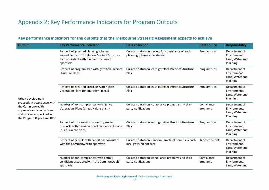
Output Key Performance Indicator Data collection Data source Responsibility
Urban development proceeds in accordance with the Commonwealth approvals and mechanisms and processes specified in the Program Report and BCS
Per cent of gazetted planning scheme amendments to introduce a Precinct Structure Plan consistent with the Commonwealth approvals
Collated data from review for consistency of each planning scheme amendment
Program files Department of Environment, Land, Water and Planning
Per cent of program area with gazetted Precinct Structure Plans
Collated data from each gazetted Precinct Structure Plan
Program files Department of Environment, Land, Water and Planning
Per cent of gazetted precincts with Native Vegetation Plans (or equivalent plans)
Collated data from each gazetted Precinct Structure Plan
Program files Department of Environment, Land, Water and Planning
Number of non-compliances with Native Vegetation Plans (or equivalent plans)
Collated data from compliance programs and third party notifications
Compliance programs
Department of Environment, Land, Water and Planning
Per cent of conservation areas in gazetted precincts with Conservation Area Concept Plans (or equivalent plans)
Collated data from each gazetted Precinct Structure Plan
Program files Department of Environment, Land, Water and Planning
Per cent of permits with conditions consistent with the Commonwealth approvals
Collated data from random sample of permits in each local government area
Random sample Department of Environment, Land, Water and Planning
Number of non-compliances with permit conditions associated with the Commonwealth approvals
Collated data from compliance programs and third party notifications
Compliance programs
Department of Environment, Land, Water and

Monitoring and Reporting Framework Melbourne Strategic Assessment 27
Output Key Performance Indicator Data collection Data source Responsibility
Planning
Number of approved adjustments to conservation area boundaries
Collated data from each Commonwealth and DELWP approval
Program files Department of Environment, Land, Water and Planning
Number of approved development or works in conservation areas
Collated data from each Commonwealth and DELWP approval
Program files Department of Environment, Land, Water and Planning
Number of cases of illegal removal of native vegetation and habitat within conservation areas
Collated data from compliance programs and third party notifications
Compliance programs
Department of Environment, Land, Water and Planning
Number of cases of illegal removal of native vegetation and habitat outside conservation areas
Collated data from compliance programs and third party notifications
Compliance programs
Department of Environment, Land, Water and Planning
Per cent of gazetted precincts with approved Integrated Water Management Plans
Data collected from each approved Integrated Water Management Plan
Program files Metropolitan Planning Authority
Number of non-compliance with approved Environmental Management Plan for the Regional Rail Link (section 2) affecting matters of national environmental significance
Collated data from compliance programs and third party notifications
Program files Department of Economic Development, Jobs, Transport and Resources
Per cent of gazetted precincts with approved Cultural Heritage Management Plans
Data collected from each approved Cultural Heritage Management Plan
Program files Metropolitan Planning Authority
Per cent of approved work plans consistent with the prescriptions or Biodiversity Conservation Strategy for Melbourne’s Growth Corridors
Data collected from each approved works authority and work plan
Program files Department of Economic Development, Jobs, Transport and Resources
Number of non-compliances with approved Collated data from compliance programs and third Program files Department of

Monitoring and Reporting Framework Melbourne Strategic Assessment 28
Output Key Performance Indicator Data collection Data source Responsibility
work plans affecting matters of national environmental significance
party notifications Economic Development, Jobs, Transport and Resources
Program cost recovery and expenditure is transparent and efficient
Revenue Collated data from financial report BMS
Department of Environment, Land, Water and Planning
Expenditure Collated data from financial report and contracts BMS
Department of Environment, Land, Water and Planning
Number of habitat hectares provided as offset Collated data from Habitat Compensation Statements
NVIM
Department of Environment, Land, Water and Planning
Number of hectares of GSM habitat with offset met
Collated data from Habitat Compensation Statements
NVIM
Department of Environment, Land, Water and Planning
Number of hectares of GGF habitat with offset met
Collated data from Habitat Compensation Statements
NVIM
Department of Environment, Land, Water and Planning
Hectares of habitat compensation obligation met
Collated data from Habitat Compensation Statements
NVIM
Department of Environment, Land, Water and Planning
Number of staged obligation agreements Collated data from agreements NVIM
Department of Environment, Land, Water and Planning

Monitoring and Reporting Framework Melbourne Strategic Assessment 29
Output Key Performance Indicator Data collection Data source Responsibility
Number of Works in Kind Agreements Collated data from agreements NVIM
Department of Environment, Land, Water and Planning
Value of Works in Kind Agreements Collated data from agreements NVIM
Department of Environment, Land, Water and Planning
Hectares of offsets provided to development within the Melbourne Urban Development Policy area
Collated data from agreements NVIM
Department of Environment, Land, Water and Planning
Hectares of offsets provided from changes to Conservation Area boundaries
Collated data from agreements NVIM
Department of Environment, Land, Water and Planning
The 15,000 hectare grassland reserve is established and managed outside the Urban Growth Boundary
Parcels under interim management Collated data from contracts, agreements and associated reports
Program files
Department of Environment, Land, Water and Planning
Number of landowners participating in interim management
Collated data from contracts, agreements and associated reports
Program files
Department of Environment, Land, Water and Planning
Units of interim land management (DELWP Standard Outputs)
Collated data from contracts, agreements and associated reports
Program files
Department of Environment, Land, Water and Planning
Hectares of land secured Collated data from notification of completed land purchase forms
Program files
Department of Environment, Land, Water and Planning

Monitoring and Reporting Framework Melbourne Strategic Assessment 30
Output Key Performance Indicator Data collection Data source Responsibility
Per cent of reserve secured Calculated from hectares of land acquired Program files
Department of Environment, Land, Water and Planning
Hectares of EPBC-listed community secured
Vegetation mapping GIS files NVIM
Department of Environment, Land, Water and Planning
Hectares of Ecological Vegetation Class secured Vegetation mapping GIS files NVIM
Department of Environment, Land, Water and Planning
Units of land management (DELWP Standard Outputs) undertaken
Collated data from land manager reports and data submissions and contracts
Parks Victoria
A network of Conservation Areas within the Urban Growth Boundary is protected and managed for MNES species and vegetation communities
Hectares of land secured Collated data from notification of completed land purchase forms and Agreements for permanent protection on-title
Program files
Department of Environment, Land, Water and Planning
Per cent of conservation area secured Calculated from hectares of land secured Program files
Department of Environment, Land, Water and Planning
Hectares of land secured through purchase/ transfer by the Crown
Collated data from notification of completed land purchase forms
Program files
Department of Environment, Land, Water and Planning
Hectares of land secured through vesting in a public authority and permanent protection agreement on-title with management plan
Collated data from notification of completed land transfer forms and Agreements for permanent protection on-title
Program files
Department of Environment, Land, Water and Planning
Hectares of land secured through permanent protection agreement on-title with management plan
Collated data from Agreements for permanent protection on-title
Program files
Department of Environment, Land, Water and Planning
Monitoring and Reporting Framework Melbourne Strategic Assessment 31
Output Key Performance Indicator Data collection Data source Responsibility
Hectares of land secured through permanent protection agreement on-title
Collated data from Agreements for permanent protection on-title
Program files
Department of Environment, Land, Water and Planning
Hectares of EPBC-listed community secured Vegetation mapping GIS files NVIM
Department of Environment, Land, Water and Planning
Hectares of Ecological Vegetation Class secured Vegetation mapping GIS files NVIM
Department of Environment, Land, Water and Planning
Number of key populations secured Species inventory Program files
Department of Environment, Land, Water and Planning
Units of land management (DELWP Standard Outputs) undertaken
Collated data from land manager reports and data submissions, Works in Kind Agreements and contracts
Program files
Department of Environment, Land, Water and Planning
A 1,200 hectare Grassy Eucalypt Woodland Reserve protected and managed
Hectares of land secured Collated data from notification of completed land purchase forms
Program files
Department of Environment, Land, Water and Planning
Per cent of reserve secured Calculated from hectares of land acquired Program files
Department of Environment, Land, Water and Planning
Total hectares secured through purchase by the Crown
Collated data from notification of completed land purchase forms
Program files
Department of Environment, Land, Water and Planning
Hectares of land secured through permanent protection agreement on-title with management plan
Collated data from Agreements for permanent protection on-title
Program files
Department of Environment, Land, Water and Planning

Monitoring and Reporting Framework Melbourne Strategic Assessment 32
Output Key Performance Indicator Data collection Data source Responsibility
Hectares of land secured through permanent protection agreement on-title
Collated data from Agreements for permanent protection on-title
Program files
Department of Environment, Land, Water and Planning
Hectares of EPBC-listed community secured Vegetation mapping GIS files NVIM
Department of Environment, Land, Water and Planning
Hectares of Ecological Vegetation Class secured Vegetation mapping GIS files NVIM
Department of Environment, Land, Water and Planning
Units of land management (DELWP Standard Outputs) undertaken
Collated data from land manager reports and data submissions and contracts
Program files
Department of Environment, Land, Water and Planning
80% of Grassy Eucalypt Woodland within the UGB is protected
Hectares of Grassy Eucalypt Woodland secured
Calculated from data from notification of completed land transfer forms and Agreements for permanent protection on-title and Hectares of EPBC listed community
Program files
Department of Environment, Land, Water and Planning
Per cent of Grassy Eucalypt Woodland secured Calculated from Hectares of Grassy Eucalypt Woodland secured
Program files
Department of Environment, Land, Water and Planning
80% of high priority habitat for Golden Sun Moth protected and managed
Hectares of high priority habitat protected
Calculated from data from notification of completed land transfer forms and Agreements for permanent protection on-title
Program files
Department of Environment, Land, Water and Planning
Per cent of high priority habitat protected
Calculated from Hectares of highest priority habitat secured Program files
Department of Environment, Land, Water and Planning
Hectares of land secured Collated from notification of completed land purchase forms and agreements for permanent protection on-title
Program files
Department of Environment, Land, Water and Planning

Monitoring and Reporting Framework Melbourne Strategic Assessment 33
Output Key Performance Indicator Data collection Data source Responsibility
Hectares of high priority habitat secured through purchase by the Crown
Collated data from notification of completed land purchase forms
Program files
Department of Environment, Land, Water and Planning
Hectares of land secured through permanent protection agreement on-title with management plan
Collated data from Agreements for permanent protection on-title
Program files
Department of Environment, Land, Water and Planning
Hectares of EPBC-listed community secured Vegetation mapping GIS files DELWP - NVIM
Department of Environment, Land, Water and Planning
Hectares of Ecological Vegetation Class secured Vegetation mapping GIS files DELWP - NVIM
Department of Environment, Land, Water and Planning
Units of land management (DELWP Standard Outputs) undertaken
Collated data from land manager reports and data submissions and contracts
Program files
Department of Environment, Land, Water and Planning
80% of the high priority habitats for Spiny Rice-flower protected and managed
Hectares of high priority habitat protected
Calculated from data from notification of completed land transfer forms and Agreements for permanent protection on-title
Program files
Department of Environment, Land, Water and Planning
Per cent of high priority habitat protected
Calculated from Hectares of highest priority habitat secured Program files
Department of Environment, Land, Water and Planning
Hectares of land secured Collated from notification of completed land purchase forms and agreements for permanent protection on-title
Program files
Department of Environment, Land, Water and Planning
Hectares of land secured through purchase by the Crown
Collated data from notification of completed land purchase forms
Program files
Department of Environment, Land, Water and Planning

Monitoring and Reporting Framework Melbourne Strategic Assessment 34
Output Key Performance Indicator Data collection Data source Responsibility
Hectares of land secured through permanent protection agreement on-title with management plan
Collated data from Agreements for permanent protection on-title
Program files
Department of Environment, Land, Water and Planning
Hectares of EPBC-listed community secured Vegetation mapping GIS files NVIM
Department of Environment, Land, Water and Planning
Hectares of Ecological Vegetation Class secured Vegetation mapping GIS files NVIM
Department of Environment, Land, Water and Planning
Units of land management (DELWP Standard Outputs) undertaken
Collated data from land manager reports and data submissions and contracts
Program files
Department of Environment, Land, Water and Planning
80% of the highest priority habitats for Matted Flax-lily is protected and managed
Hectares of highest priority habitat protected
Calculated from data from notification of completed land transfer forms and Agreements for permanent protection on-title
Program files
Department of Environment, Land, Water and Planning
Per cent of highest priority habitat protected
Calculated from Hectares of highest priority habitat secured Program files
Department of Environment, Land, Water and Planning
Hectares of highest priority habitat secured outside the UGB
Calculated from data from notification of completed land transfer forms and Agreements for permanent protection on-title
Program files
Department of Environment, Land, Water and Planning
Per cent of highest priority habitat secured outside the UGB
Calculated from Hectares of highest priority habitat secured Program files
Department of Environment, Land, Water and Planning
Hectares of land secured through purchase by the Crown
Collated data from notification of completed land purchase forms
Program files
Department of Environment, Land, Water and Planning

Monitoring and Reporting Framework Melbourne Strategic Assessment 35
Output Key Performance Indicator Data collection Data source Responsibility
Hectares of land secured through permanent protection agreement on-title with management plan
Collated data from Agreements for permanent protection on-title
Program files
Department of Environment, Land, Water and Planning
Hectares of EPBC-listed community secured Vegetation mapping GIS files NVIM
Department of Environment, Land, Water and Planning
Hectares of Ecological Vegetation Class secured Vegetation mapping GIS files NVIM
Department of Environment, Land, Water and Planning
Units of land management (DELWP Standard Outputs) undertaken
Collated data from land manager reports and data submissions and contracts
Program files
Department of Environment, Land, Water and Planning
Important landscape and habitat areas for Southern Brown Bandicoot are protected and managed
Hectares of private land with management agreement
Collated data from Agreements for permanent protection on-title
Program files
Department of Environment, Land, Water and Planning
Hectares of public land with management agreement
Collated data from Agreements management on public land and contracts
Program files
Department of Environment, Land, Water and Planning
Hectares under landscape scale predator control program
Collated data from land manager reports and data submissions and contracts
Program files
Department of Environment, Land, Water and Planning
Units of land management (DELWP Standard Outputs) undertaken
Collated data from land manager reports and data submissions and contracts
Program files
Department of Environment, Land, Water and Planning

Monitoring and Reporting Framework Melbourne Strategic Assessment 36
Appendix 3: Key Performance Indicators for Program Outcomes
Key performance indicators for the outcomes that the Melbourne Strategic Assessment expects to achieve
Outcome Key Performance Indicator Data collection Data source
Responsibility
The composition, structure and function of Natural Temperate Grassland improves
Hectares making transitions between states Mapping undertaken between August and December undertaken every five years compared to previous reporting period
NVIM
Department of Environment, Land, Water and Planning
Cover of native perennial herbs Estimated cover of perennial herbs in all 20 X 20 m plots in NTG states monitored in spring annually
Diversity of native perennial herbs Estimated diversity of native perennial herbs in all 20 x 20 m plots in NTG states monitored in spring annually
Cover of Kangaroo Grass (Themeda triandra) Estimated cover of Kangaroo Grass in 20 x 20 plots in NTG states monitored in spring annually
Cover of native perennial grasses (excluding Kangaroo Grass)
Estimated cover of native perennial grasses (excluding Kangaroo Grass) in all 20 x 20m plots in NTG states monitored in spring annually.
Per cent of plots that have bare ground cover between 25-75%
Per cent of rapid monitoring plots in the target cover range monitored in pring annually
Per cent of all perennial vegetation comprised of weeds
Per cent of perennial vegetation which is composed of weeds in
permanent 20 x 20 m plots collected in spring annually compared to the
original per cent cover in that plot in the year of acquisition.
The composition, structure and function of Grassy Eucalypt Woodland improves
Hectares making transitions between states Mapping undertaken between August and December undertaken every five years compared to previous reporting period
NVIM
Department of Environment, Land, Water and Planning
Cover of native perennial herbs Estimated cover of perennial herbs in all 20 X 20 m plots in GEW states monitored in spring annually
Diversity of native perennial herbs Estimated diversity of native perennial herbs in all 20 x 20 m plots in GEW states monitored in spring annually
Cover of target species( Themeda triandra, Poa spp. Austrostipa mollis)
Estimated cover of target grass species in all 20 x 20 plots in GEW states monitored in spring annually

Monitoring and Reporting Framework Melbourne Strategic Assessment 37
Outcome Key Performance Indicator Data collection Data source
Responsibility
Relative abundance of woodland structural types Per cent of 50 x 50 m plots in the target cover range for each woodland structure category, monitored in spring annually.
Per cent of plots with Eucalypt recruits Per cent of 50 x 50 m plots with Eucalypt recruits monitored in spring annually
Per cent of all perennial vegetation composed of perennial weeds
Per cent of perennial vegetation which is weeds in permanent 20 x 20 m plots collected in spring annually compared to the original per cent cover in that plot in the year land is secured.
The composition, structure and function of Seasonal Herbaceous Wetlands (freshwater) improves
Diversity of native perennial herbs during spring-summer
Estimated diversity of native perennial herbs collected in spring- summer annually in each wetland >three ha compared to the mean diversity for that wetland five years after land is secured.
Department of Environment, Land, Water and Planning
Diversity of all native herbs during drawdown
Estimated diversity of all native herbs collected one month after observed peak water level in each wetland >three ha compared to the mean diversity for that wetland for drawndown events within the first five years of land being secured.
Per cent of all perennial vegetation during Spring-Summer composed of weeds
Per cent of vegetation which is perennial weeds in each wetland >three ha in extent monitored in spring-summer annually compared to the original per cent in that wetland in the year land is secured
Per cent of all perennial vegetation during drawdown composed of weeds
Per cent of vegetation which is perennial weeds in each wetland >three ha in extent monitored one month after observed peak water level compared to the original per cent in that wetland in the first drawdown event after the land is secured..
No substantial negative change to populations of Button Wrinklewort
Average annual population count over last five years Calculated from annual population counts using transects monitored between November and December
VBA
Department of Environment, Land, Water and Planning
No substantial negative change to populations of Large-fruit Groundsel
Average annual population count over last five years Calculated from annual population counts using transects monitored between September 1st and November 30th
VBA
Department of Environment, Land, Water and Planning
No substantial negative change to populations of Maroon Leek-orchid
Count of individuals emergent at least once over a five year period
Calculated from annual population counts to locate emergent individuals monitored between September 1st and October 31st
VBA
Department of Environment, Land, Water and Planning

Monitoring and Reporting Framework Melbourne Strategic Assessment 38
Outcome Key Performance Indicator Data collection Data source
Responsibility
No substantial negative change to populations of Matted Flax-lily
Average annual population count over last five years Average calculated from annual population count using transects monitored between October to January
VBA
Department of Environment, Land, Water and Planning
No substantial negative change to populations of Small Golden Moths Orchid
Count of individuals emergent at least once over a five year period
Calculated from annual population counts using transects to locate
emergent monitored between September 1st and October 31
st VBA
Department of Environment, Land, Water and Planning
No substantial negative change to populations of Spiny Rice-flower, and populations are self-sustaining
Five year annual average population density Calculated from annual population counts using transects monitored between May to August
VBA
Department of Environment, Land, Water and Planning Number of years that recruits form over 10% of the
population over a 10 year period Calculated from annual population counts for each conservation area using plots monitored between May to August
Golden Sun Moth persists
Proportion of monitored sites that are occupied Calculated from transects to identify occupied sites, conducted between November and January annually VBA
Department of Environment, Land, Water and Planning
Growling Grass Frog persists
Projected risk of extinction for each Conservation Area, estimated using a stochastic patch-occupancy model for Growling Grass Frog metapopulations
Predictions of extinction risk from the stochastic patch occupancy model, incorporating all available occupancy and habitat data for each Conservation Area.
VBA
Department of Environment, Land, Water and Planning
Southern Brown Bandicoot persists
Proportion of monitored sites that are occupied Calculated from camera trap surveys conducted every five years VBA
Department of Environment, Land, Water and Planning
Striped Legless Lizard persists
Proportion of permanent monitoring plots that are occupied
Calculated from tile grid surveys conducted between November and December annually VBA
Department of Environment, Land, Water and Planning

Monitoring and Reporting Framework Melbourne Strategic Assessment 39
Appendix 3: Key Performance Indicators for Broader outcomes
Key performance indicators for the broader outcomes that the Melbourne Strategic Assessment will contribute to
Broad Outcome Key Performance Indicator Melbourne Strategic Assessment Data contribution
Reporting
Ecologically sustainable development through the conservation and ecologically sustainable use of natural resources
Progress against outcomes Output progress report and five yearly outcome reports
Nation-wide reporting undertaken by Department of Environment
Our natural assets are protected and there is better planning of our water, energy and waste management systems to create a sustainable city
Progress against outputs and outcomes
Output process report and five yearly outcome reports
Melbourne Reporting undertaken by Metropolitan Planning Authority
Conservation measures achieve appropriate mitigation of impacts on biodiversity
Progress against outputs and outcomes
Output progress report and five yearly outcome reports
State-wide reporting undertaken by Department of Environment, Land, Water and Planning

www.delwp.vic.gov.au