modernization of meteorological services in...
TRANSCRIPT

Japan Meteorological Business Support Center (JMBSC)
MODERNIZATION OF
Meteorological Services in Japan
AND LESSONSFOR DEVELOPING COUNTRIES

Project Team of the Japan Meteorological Business Support Center (JMBSC): Mitsuhiko Hatori (Lead), Tokiyoshi Toya, Michihiko Tonouchi, Hiroshi Yokoyama, Masao Mikami, Tsutomu Jyoumura, and Yasutaka Makihara
On the cover: JMA’s mascot, “Hare-run,” incorporates elements of the sun, clouds, and rainfall, with a green baton representing hopes for a peaceful and disaster-free world.

Contents 1
Table of ContentsExecutive Summary . . . . . . . . . . . . . . . . . . . . . . . . . . . . . . . . . . . . . . . . . . . . . . . . . . . . . . . . . .5
1 . Weather and Climate Services in Japan . . . . . . . . . . . . . . . . . . . . . . . . . . . . . . . . . . . . . .71 .1 Natural Hazards in Japan . . . . . . . . . . . . . . . . . . . . . . . . . . . . . . . . . . . . . . . . . . . . . . . . . . . . . . . . . 7
1 .1 .1 Geography and Climate of Japan . . . . . . . . . . . . . . . . . . . . . . . . . . . . . . . . . . . . . . . . . . . . . . 71 .1 .2 Natural Hazards in Japan . . . . . . . . . . . . . . . . . . . . . . . . . . . . . . . . . . . . . . . . . . . . . . . . . . . . 8
1 .2 Evolution of Meteorological Services in Japan . . . . . . . . . . . . . . . . . . . . . . . . . . . . . . . . . . . . . . . . 91 .2 .1 Meteorological Services in the Early Development Years . . . . . . . . . . . . . . . . . . . . . . . . . . 91 .2 .2 Establishment of Institutional Frameworks . . . . . . . . . . . . . . . . . . . . . . . . . . . . . . . . . . . . . 91 .2 .3 Modernization Stages in the Evolution of Meteorological Services over 60 Years . . . . 111 .2 .4 Key Drivers for Modernization over 140 Years . . . . . . . . . . . . . . . . . . . . . . . . . . . . . . . . . . 11
1 .3 Business Model of the National Meteorological Service in Japan . . . . . . . . . . . . . . . . . . . . . . 131 .3 .1 Operating Model of JMA as NMS . . . . . . . . . . . . . . . . . . . . . . . . . . . . . . . . . . . . . . . . . . . . . 131.3.2 Profile of Major Users of Meteorological Services in Japan . . . . . . . . . . . . . . . . . . . . . . 131 .3 .3 Meteorological Services Value Chain in Japan . . . . . . . . . . . . . . . . . . . . . . . . . . . . . . . . . 13
1 .4 Current Meteorological Services in Japan . . . . . . . . . . . . . . . . . . . . . . . . . . . . . . . . . . . . . . . . . . . 141 .4 .1 Information and Communication Network between JMA and
Stakeholders/User Communities . . . . . . . . . . . . . . . . . . . . . . . . . . . . . . . . . . . . . . . . . . . . . 151 .4 .2 Observation and Monitoring Services . . . . . . . . . . . . . . . . . . . . . . . . . . . . . . . . . . . . . . . . . 151 .4 .3 Information Dissemination Services . . . . . . . . . . . . . . . . . . . . . . . . . . . . . . . . . . . . . . . . . . 161 .4 .4 International Cooperation with WMO and Other International
and Regional Organizations . . . . . . . . . . . . . . . . . . . . . . . . . . . . . . . . . . . . . . . . . . . . . . . . . 161 .4 .5 Research and Development, and Education and Training . . . . . . . . . . . . . . . . . . . . . . . . . 17
2 . Institutional Evolution of Meteorological Services in Japan . . . . . . . . . . . . . . . . . . . .182 .1 Legal Framework . . . . . . . . . . . . . . . . . . . . . . . . . . . . . . . . . . . . . . . . . . . . . . . . . . . . . . . . . . . . . . . . 18
2 .1 .1 Meteorological Service Act . . . . . . . . . . . . . . . . . . . . . . . . . . . . . . . . . . . . . . . . . . . . . . . . . . 182 .1 .2 Collaboration Mechanism with Partners . . . . . . . . . . . . . . . . . . . . . . . . . . . . . . . . . . . . . . 19 Observation Networks . . . . . . . . . . . . . . . . . . . . . . . . . . . . . . . . . . . . . . . . . . . . . . . . . . . . . . 19 Dissemination of Warnings . . . . . . . . . . . . . . . . . . . . . . . . . . . . . . . . . . . . . . . . . . . . . . . . . . 192.1.3 Major Amendments to the Act . . . . . . . . . . . . . . . . . . . . . . . . . . . . . . . . . . . . . . . . . . . . . . . 21 Introduction of Early Warning System for Earthquakes and Volcanic Eruptions . . . . . 21 Enhancement of Public-Private Partnership (PPP) . . . . . . . . . . . . . . . . . . . . . . . . . . . . . . 21 Introduction of Emergency Warning System . . . . . . . . . . . . . . . . . . . . . . . . . . . . . . . . . . . 222 .1 .4 Policy-making and Coordination Mechanisms in Meteorological Services . . . . . . . . . . 22
2 .2 Roles and Responsibilities of JMA within the Framework of Government Disaster Countermeasures . . . . . . . . . . . . . . . . . . . . . . . . . . . . . . . . . . . . . . . . . . . . . . . . . . . . . . . . . . . . . . . 232 .2 .1 Structure of JMA . . . . . . . . . . . . . . . . . . . . . . . . . . . . . . . . . . . . . . . . . . . . . . . . . . . . . . . . . . 232 .2 .2 Disaster Countermeasures of the Government and JMA . . . . . . . . . . . . . . . . . . . . . . . . 242 .2 .3 Integration of Government Countermeasures for Disaster Risk Reduction (DRR) . . . . 25
2.3 Budget, Staffing, and Human Resources Development . . . . . . . . . . . . . . . . . . . . . . . . . . . . . . . . 26

2 Modernization of Meteorological Services in Japan
2.3.1 Budget and Staffing of JMA . . . . . . . . . . . . . . . . . . . . . . . . . . . . . . . . . . . . . . . . . . . . . . . . . 262 .3 .2 Development of Human Resources in JMA . . . . . . . . . . . . . . . . . . . . . . . . . . . . . . . . . . . . 26
3 . Modernization of Observation and Forecasting Systems and Service Delivery in Japan . . . . . . . . . . . . . . . . . . . . . . . . . . . . . . . . . . . . . . . . . . . . . .29
3 .1 Modernization of JMA Operational Systems and Improvement of Services . . . . . . . . . . . . . . 293 .1 .1 General Description . . . . . . . . . . . . . . . . . . . . . . . . . . . . . . . . . . . . . . . . . . . . . . . . . . . . . . . . 29 Modernization through Long-term Sustainable Efforts . . . . . . . . . . . . . . . . . . . . . . . . . . 29 Strategic Management and Planning Cycles to Enhance Service Delivery . . . . . . . . . . 293 .1 .2 Policy on the System Development and Operation for Quality Assurance
of Service Delivery in JMA . . . . . . . . . . . . . . . . . . . . . . . . . . . . . . . . . . . . . . . . . . . . . . . . . . . 30 System Development and Crisis Management . . . . . . . . . . . . . . . . . . . . . . . . . . . . . . . . . 30 System Integration and Management by JMA in the Development and
Operation Processes . . . . . . . . . . . . . . . . . . . . . . . . . . . . . . . . . . . . . . . . . . . . . . . . . . . . . . . 31 Maintenance of On-site Instruments and Quality Assurance . . . . . . . . . . . . . . . . . . . . . 31 Monitoring, Forecast and Warning Services in the Responsible Offices . . . . . . . . . . . . 31 Long-term Data Archive and Database Development . . . . . . . . . . . . . . . . . . . . . . . . . . . . 333 .1 .3 Evolution of Meteorological Equipment Industry . . . . . . . . . . . . . . . . . . . . . . . . . . . . . . . . 343 .1 .4 Modernization from the Service Delivery Aspect for Severe Weather . . . . . . . . . . . . . . 34 Improvement of Typhoon Forecast and Daily Weather Forecast . . . . . . . . . . . . . . . . . . 34 Enhancement of Risk-based Early Warning Services . . . . . . . . . . . . . . . . . . . . . . . . . . . . 36
3.2 Early Warning Services and User Interface . . . . . . . . . . . . . . . . . . . . . . . . . . . . . . . . . . . . . . . . . . 393 .2 .1 Early Warning Systems for Severe Weather Events . . . . . . . . . . . . . . . . . . . . . . . . . . . . . . 39 Seamless Early Warning Systems . . . . . . . . . . . . . . . . . . . . . . . . . . . . . . . . . . . . . . . . . . . . 39 Multi-hazard Approach for Weather-related Severe Events . . . . . . . . . . . . . . . . . . . . . . . 393 .2 .2 Application of Weather Services for DRR in a Domestic Setting . . . . . . . . . . . . . . . . . . . 43 Interface with Central and Local Governments . . . . . . . . . . . . . . . . . . . . . . . . . . . . . . . . . 43 Interface with the Mass Media, the Private Sector and the Public . . . . . . . . . . . . . . . . . 44 Expansion of the Internet and Mobile Media as the Interface with the Public for DRR . . . . . . . . . . . . . . . . . . . . . . . . . . . . . . . . . . . . . . . . . . . . . . . . . . . . . . . . . . . . . 463 .2 .3 Comprehensive Multi-hazard Approach for Severe Events Including Earthquakes . . . 463 .2 .4 Exchange of Observation Data with Relevant Authorities to improve Service Delivery . . . . . . . . . . . . . . . . . . . . . . . . . . . . . . . . . . . . . . . . . . . . . . . . . . 523 .2 .5 Collaboration with Hydrological Services in Early Warnings for Floods and Landslides . . . . . . . . . . . . . . . . . . . . . . . . . . . . . . . . . . . . . . . . . . . . . . . . . . . . . . . . . . . . 52 Flood Warnings for Specific Rivers . . . . . . . . . . . . . . . . . . . . . . . . . . . . . . . . . . . . . . . . . . . 52 Landslide Alert Information . . . . . . . . . . . . . . . . . . . . . . . . . . . . . . . . . . . . . . . . . . . . . . . . . . 52
3 .3 Application of Weather and Climate Services in Socio-economic Activities . . . . . . . . . . . . . . . . . . . . . . . . . . . . . . . . . . . . . . . . . . . . . . . . . . . . . . . . . . . . . . . . . . . . . . . 563 .3 .1 Application of Climate Services in Socio-economic Activities . . . . . . . . . . . . . . . . . . . . 563 .3 .2 Application of Weather Services in Aviation Community . . . . . . . . . . . . . . . . . . . . . . . . . 57 Air Traffic Meteorology Center . . . . . . . . . . . . . . . . . . . . . . . . . . . . . . . . . . . . . . . . . . . . . . . 57 Volcanic Ash Advisory . . . . . . . . . . . . . . . . . . . . . . . . . . . . . . . . . . . . . . . . . . . . . . . . . . . . . . 59
3.4 Utilization of and User-satisfaction with Meteorological Services . . . . . . . . . . . . . . . . . . . . . . 59

Contents 3
4 . Evolution of the Public-Private Partnership . . . . . . . . . . . . . . . . . . . . . . . . . . . . . . . . . .604 .1 Evolution of the Public-Private Partnership in Weather and Climate Services . . . . . . . . . . . . . 604 .2 JMBSC and its Services in Support of the Public-Private Partnership (PPP) . . . . . . . . . . . . . . 624.3 Expansion of Meteorological Data Traffic in the Industry . . . . . . . . . . . . . . . . . . . . . . . . . . . . . . 634 .4 Private Meteorological Services in Japan . . . . . . . . . . . . . . . . . . . . . . . . . . . . . . . . . . . . . . . . . . . 66
4 .4 .1 Key Institutional Bases for Private Meteorological Services in Japan . . . . . . . . . . . . . . 664 .4 .2 Current Services and Business Model of Private Meteorological Companies . . . . . . . 66
5. Experiences in International Programs and Projects . . . . . . . . . . . . . . . . . . . . . . . . . .715 .1 Geostationary Meteorological Satellite . . . . . . . . . . . . . . . . . . . . . . . . . . . . . . . . . . . . . . . . . . . . . 71
5 .1 .1 Himawari-8/9 and its International Contribution . . . . . . . . . . . . . . . . . . . . . . . . . . . . . . . . 715 .1 .2 Good Practices in Himawari-series Satellite Services with the
Support of NWP Models . . . . . . . . . . . . . . . . . . . . . . . . . . . . . . . . . . . . . . . . . . . . . . . . . . . . 735 .1 .3 Further Enhancement of Himawari-Series Satellite Services . . . . . . . . . . . . . . . . . . . . . 74
5 .2 Regional and World Centers in JMA under WMO Programmes . . . . . . . . . . . . . . . . . . . . . . . . . 755 .2 .1 International Communication System Centre and Regional Specialized
Meteorological Centres (RSMCs) . . . . . . . . . . . . . . . . . . . . . . . . . . . . . . . . . . . . . . . . . . . . . 75 Functions of the International Communication System Centre and RSMCs . . . . . . . . . 75 Contribution to the WMO Information System (WIS) . . . . . . . . . . . . . . . . . . . . . . . . . . . . 755 .2 .2 Regional Specialized Meteorological Centre (RSMC) Tokyo–Typhoon Center . . . . . . . 77 Key Activities of RSMC Tokyo–Typhoon Center . . . . . . . . . . . . . . . . . . . . . . . . . . . . . . . . 77 Good Practices of RSMC Tokyo–Typhoon Center to Support Developing Countries . 775 .2 .3 Key Lessons Learned from GISC and RSMCs Activities . . . . . . . . . . . . . . . . . . . . . . . . . . 79
5 .3 Training Programs and JICA Training Courses in Meteorology . . . . . . . . . . . . . . . . . . . . . . . . . 795 .3 .1 Lessons Learned from Training Courses . . . . . . . . . . . . . . . . . . . . . . . . . . . . . . . . . . . . . . 795 .3 .2 Good Practices in JICA Training Courses . . . . . . . . . . . . . . . . . . . . . . . . . . . . . . . . . . . . . . 80
5.4 Experiences in JICA Projects . . . . . . . . . . . . . . . . . . . . . . . . . . . . . . . . . . . . . . . . . . . . . . . . . . . . . . 815 .4 .1 Key Lessons Learned . . . . . . . . . . . . . . . . . . . . . . . . . . . . . . . . . . . . . . . . . . . . . . . . . . . . . . . 815.4.2 Good Practices of JICA Projects related to Meteorological Services . . . . . . . . . . . . . . . 83
6 . Guidance on Modernizing NMHSs . . . . . . . . . . . . . . . . . . . . . . . . . . . . . . . . . . . . . . . . . .856 .1 Recommendations for Developing Countries . . . . . . . . . . . . . . . . . . . . . . . . . . . . . . . . . . . . . . . . 856.2 Recommendations for Designing and Implementing Modernization Projects . . . . . . . . . . . . 88
A Note on Proposed Next Steps . . . . . . . . . . . . . . . . . . . . . . . . . . . . . . . . . . . . . . . . . . . . . .92
Closing Remarks . . . . . . . . . . . . . . . . . . . . . . . . . . . . . . . . . . . . . . . . . . . . . . . . . . . . . . . . . . .94
Acknowledgements to Contributing Stakeholders . . . . . . . . . . . . . . . . . . . . . . . . . . . . . . .95
Annexes . . . . . . . . . . . . . . . . . . . . . . . . . . . . . . . . . . . . . . . . . . . . . . . . . . . . . . . . . . . . . . . . . .97

4 Modernization of Meteorological Services in Japan
List of BoxesChapter 11 .1 Initiation of Meteorological Services and International
Cooperation in the 19th Century . . . . . . . . . . . . . . . . . . . . . . . . . . . . . . . . . . . . . . . . . . . . . . . . . . . 10Chapter 22.1 Socio-economic Benefits and Meteorological Services in Japan . . . . . . . . . . . . . . . . . . . . . . . 27 2 .2 Human Resources Development in JMA–Education and Training Courses
for Technical and Management Staff . . . . . . . . . . . . . . . . . . . . . . . . . . . . . . . . . . . . . . . . . . . . . . 28Chapter 33 .1 Recovery Efforts and Enhancement of AMeDAS Stations after the
2011 Great East Japan Earthquake . . . . . . . . . . . . . . . . . . . . . . . . . . . . . . . . . . . . . . . . . . . . . . . . 323 .2 Criteria of Risk-based Warning in JMA . . . . . . . . . . . . . . . . . . . . . . . . . . . . . . . . . . . . . . . . . 37–383 .3 Example of Real-time Information Issued by LMOs in
Seamless Early Warning Systems . . . . . . . . . . . . . . . . . . . . . . . . . . . . . . . . . . . . . . . . . . . . . 41–423 .4 Comprehensive Multi-hazard Approach
following the 2011 Great East Japan Earthquake . . . . . . . . . . . . . . . . . . . . . . . . . . . . . . . . 50–51Chapter 44 .1 Application of Meteorological Information in Power Corporations . . . . . . . . . . . . . . . . . . . . . . 65 4 .2 Application of Meteorological Information by Airline Companies . . . . . . . . . . . . . . . . . . . . . . . 67 4 .3 Typical Private Meteorological Services . . . . . . . . . . . . . . . . . . . . . . . . . . . . . . . . . . . . . . . . 69–70

Executive Summary 5
Executive Summary
Multi-Hazards and Society’s Coping and Adaptive CapacitiesJapan is an island arc country located in the northwest of the Pacific Rim. In light of Japan’s geographical and climatological features, the country’s natural hazards comprise weather-, climate-, ocean-, and seismic-related hazards. Through the extensive efforts of the Japan Meteorological Agency (JMA) and its collaborating authorities in improving early warning and disaster management systems and in raising public awareness, the damage caused by natural disasters and the impacts on socio-economic activities have been significantly reduced in accordance with the development of infrastructure and enhancement of society’s coping and adaptive capacities to reduce vulnerability to natural hazards.
Institutional Foundation of Meteorological ServicesThe National Meteorological Service (NMS) in Japan was inaugurated in 1875. After 70 years of scientific research/services (the early development years), meteorological services in Japan entered into the initial stage of modernization after World War II. The legal framework was established in 1952 by the formulation of the Meteorological Service Act, which specifically defined the roles and responsibilities of JMA and its partners as well as the collaboration mechanism. Japan joined the World Meteorological Organization (WMO) in 1953, and JMA was inaugurated in 1956, when its solid institutional framework of services was fully established as NMS.
Step-by-step Modernization of Meteorological Services over 60 YearsThe modernization of meteorological services in Japan has been achieved step by step in accordance with the evolution of JMA operational services through strategic investments in service delivery improvement to meet evolving and diversifying societal needs. The modernization was mainly driven by growing
user requirements and by technical support from the evolving information and communications technology (ICT). Modernization took place over 60 years in four stages: (1) initial/primitive stage of modernization (around 1950–1965); (2) nationwide automation and networking development stage (1965–1985); (3) nationwide digitization, computerization, and networking stage (1985–2005); and (4) advanced networking stage with modern ICT (2005–present). The improvement of service delivery—e.g., through more accurate forecast/warning—has been achieved by total integration of systems for observation/monitoring, analysis and information management, and forecast/warning with the long-term efforts.
Key Strategy to Tackle Multi-hazardsJMA, in collaboration with the relevant authorities, provides operational early warning services in order to reduce the risks from multiple natural hazards. The key strategies historically developed by JMA to address severe hazard events (related to weather, climate, environment, earthquakes, tsunami, oceanic events, and volcanic eruptions) are a single authoritative voice for early warning services and a comprehensive multi-hazard approach.
Solid Foundations for Effective Early Warning ServicesJMA provides the disaster management authorities, various socio-economic sectors, and the public with warnings and related information for disaster mitigation through various channels of central/local governments, the private sector (including the mass media), and JMA websites. These early warning services occur in close practical collaboration with relevant authorities and are based on a solid legal framework. JMA has developed its risk-based warning services for multi-hazards, including sequential provision of warning information (i.e., seamless early warning services) as severe natural events evolve,

6 Modernization of Meteorological Services in Japan
through the experiences of disastrous tropical cyclones, earthquakes, and volcanic activity. Adequate institutional settings, technical bases, and human resources to tackle these multi-hazards are the key foundations historically developed in Japan.
Well-organized Coordination and Collaboration MechanismsJMA has also developed well-organized coordination and collaboration mechanisms with stakeholders to improve service delivery and strengthen cooperation, and it has raised public awareness of early warning services through local governments and the mass media. JMA has made periodic assessments of the accuracy of weather forecasts, typhoon forecasts, etc. over several decades and has disclosed this information to the public.
Expanding Utilization of Meteorological Information for Socio-economic ActivitiesThe Meteorological Service Act established the legal framework for enhanced collaboration with the private sector, including authorized forecast service companies and the mass media; this framework is composed of JMA’s solidly established national services, both general (or public) and user-specific services; JMA’s status as the national single authoritative voice for early warning services; and JMA’s open data policy with the private sector. As a result of long collaborative efforts between JMA and the private sector, as well as recent rapid advances in ICT and improvements in the accuracy and quality of meteorological information provided by JMA, the utilization and application of meteorological information by the public and the industry have widely expanded in recent years.
Enhancement of International CooperationJMA is committed to international cooperation and operates a number of global and regional centers established within the frameworks of WMO and other international organizations, and has also operated a series of Japanese geostationary meteorological satellites for more than 40 years. The world-leading first third-generation geostationary meteorological satellite Himawari-8 has been welcomed by WMO and the world weather community as the start of a
new era for geostationary meteorological satellites, with the expectation that it will further contribute to the prevention and mitigation of weather-related disasters in the East Asia and Western Pacific regions. Furthermore, JMA has enhanced its capacity development activities for National Meteorological and Hydrological Services (NMHSs) in developing countries through projects fitted to the actual needs and requirements of human resources development and by providing equipment and services implemented by the Japan International Cooperation Agency (JICA), WMO, and others.
Guidance on Modernizing NMHSsThe lessons learned in Japan in the modernization of meteorological services and the experiences in international programs and projects can be utilized as comprehensive strategic guidance for developing countries. Important features include the following: (1) long-term step-by-step development efforts based on the well-defined medium- and long-term strategies; (2) solid policy, legal, and institutional frameworks; (3) single authoritative voice for warning services by the NMHS; (4) sustainable human resources development; (5) sound national observation and information systems; (6) sound operational meteorological systems and services to provide early warning services for business continuity; (7) seamless early warning services with a comprehensive multi-hazard approach; (8) total management systems with periodic assessments; and (9) coordination and collaboration mechanisms with stakeholders. For designing and implementing modernization projects, the donor community should consider the following: (1) recognition of international foundation of NMHSs’ networks; (2) existing international cooperation frameworks for meteorological services; (3) pre-assessment of actual needs, available resources, and other relevant circumstances; (4) long-term sustainable projects through step-by-step and multi-phase subprojects; (5) more importance to human resources development projects; (6) well-organized coordination mechanisms among donors and world meteorological communities; and (7) establishment of robust national meteorological services by NMHSs in support of private meteorological services.

Weather and Climate Services in Japan 7
1.1 Natural Hazards in Japan1
1.1.1 Geography and Climate of JapanJapan is an island arc country located in the northwest of the Pacific Rim. In spite of its small area (totaling 378,000 km2), the length of the island arc reaches more than 3,000 km (around 25 degrees’ difference in latitude), with the range of altitudes from sea level to over 3,000 m. As a result, its climate varies from subtropical (in the south), to mostly temperate, to
subarctic (in the north) (see Figure 1.1). Two major ocean currents—one warm (“Kuroshio,” or the Japan Current) and one cold (“Oyashio,” or the Chishima Current)—flow northeastward along the southern part of the Japanese archipelago and southward along the east coast of Japan, respectively.
On average, 26 typhoons are generated annually in the northwestern Pacific; 11 of them approach Japan (Figure 1.1) and three make landfall on Japanese main
1. Weather and Climate Services in Japan
1 See Annex A1.1 for climate and natural disasters in Japan.
Figure 1.1: View around Japan from Geostationary Meteorological Satellite Himawari-8. Based on Himawari-8 true-color composite imagery (0300 UTC, 15 July 2015)

8 Modernization of Meteorological Services in Japan
1.1.2 Natural Hazards in JapanDue to these geographical location and climatological features, the natural hazards in Japan comprise weather- and climate-related hazards (storm, heavy rains, flood, landslide, heavy snows, and extreme temperatures); ocean-related hazards (high waves and storm surge); and terrestrial (or seismic-related) hazards (earthquake, tsunami, and volcanic eruptions).
Over the course of 60 years, the Japan Meteorological Agency (JMA), acting as the National Meteorological Service (NMS) of Japan, and its collaborating authorities have worked extensively to improve early warning and disaster management systems and to raise public awareness. As a result of their efforts, the damage caused by natural disasters and the impacts on the socio-economic activities have been significantly reduced in accordance with the development of infrastructure and enhancement of society’s coping and adaptive capacities to reduce vulnerability to natural hazards (see Figure 1.2).
islands, bringing storms, storm surges, high waves, floods, and landslides. The rainy season in June–July delivers frequent heavy rains; precipitation amounts may exceed 1,000 mm/day, or around 100 mm/hour. The winter monsoon brings heavy snows, which may be as deep as several meters, to the mountainous regions and to the Sea of Japan side of the country.
Japan lies along the Pacific Ring of Fire and thus frequently experiences large earthquakes and volcanic eruptions. The recent 2011 Great East Japan Earthquake (magnitude of 9.0) and huge earthquake-induced tsunami (over 10 m high) caused over 20,000 casualties (dead or missing). Japan has 110 volcanoes, and volcanic eruptions and associated dispersion of ashes have repeatedly caused serious damage to lives, property, and socio-economic activity.
Figure 1.2: Five-year Meteorological and Hydrological Damage in Japan (1946-2015) (Numbers of casualties (dead/missing) (left) and houses destroyed (right). Based on the data from Nitta (ed.) (2015)

Weather and Climate Services in Japan 9
It should be noted that the Japanese people are inherently conscious of weather and climate, as well as earthquake and volcanic activity, and they feel very familiar with and greatly appreciate the comprehensive range of services provided by JMA. In recent years, climate change due to human-caused greenhouse gas emissions has led to increasing public concerns about frequent intense natural disasters caused by tropical cyclones and heavy rains, and about the impacts of severe heat waves on health and socio-economics.
1.2 Evolution of Meteorological Services in Japan2
Japan launched its first national meteorological service in 1875. The first-ever storm warning and weather map followed in 1883, and the first national weather forecast was issued to the public in 1884. This section illustrates what steps Japan has taken from these beginnings to the world-class services that exist today.
1.2.1 Meteorological Services in the Early Development YearsThe Tokyo Meteorological Observatory (TMO), predecessor of JMA, was inaugurated and started weather and earthquake observations in 1875. The first storm warning and weather map were issued in 1883 and the first national weather forecast in 1884. TMO was renamed the Central Meteorological Observatory (CMO) in 1887.
From its earliest days, the predecessor of JMA sought the improvement and expansion of services to meet evolving and diversifying societal needs and requirements and to keep pace with scientific and technical development. The communication and dissemination tools for the public expanded from bulletin board, flag, and newspaper to radio in 1925, and the users of meteorological services were diversified shortly thereafter to include various socio-economic sectors, such as shipping and fishery, aviation, and railway and agriculture.
After World War II, following 70 years of services during which users and stakeholders expanded, scientific research and development (R&D) grew stronger, and human resources development was promoted (the early development years), meteorological services in Japan entered into the initial stage of modernization—both in terms of science and technology and institutional frameworks
1.2.2 Establishment of Institutional FrameworksThe legal framework for meteorological services in Japan was established in 1952 by the formulation of the Meteorological Service Act, which put the roles and responsibilities of JMA into statutory form (see details in Section 2.1). Accordingly, Japan joined the World Meteorological Organization (WMO) in 1953, and JMA was inaugurated as an affiliate agency of the Ministry of Transport in 1956, when the institutional frameworks of JMA’s services were fully established as NMS. The Meteorological Expert Training School and the Research Division were established within CMO in 1922 and 1943, respectively, and JMA (or CMO at that time) strengthened its functions through two auxiliary organs, the Meteorological College in 1962 and the Meteorological Research Institute (MRI) in 1947. Basically the above institutional frameworks have not been changed over 60 years and are still valid or even advancing today.
2 See Annex A2.1 for the chronology of JMA

Box 1.1: Initiation of Meteorological Services and International Cooperation in the 19th Century
In Japan, meteorological services were initiated in 1875, with a nationwide network of meteorological observatories and communications by telegram. In those early years, Japan faced almost the same challenges that developing countries are facing today. The new Japanese government established in 1868 was assisted by many foreign experts in the drive toward modernization.
In meteorological services, Mr. Erwin Knipping from Prussia (present Germany) joined TMO in 1882 to support the establishment of the first warning system with weather map. The first weather map and warning were issued in 1883 (see Figure 1.3), and TMO joined the International Meteorological Organization (predecessor of WMO) in 1885. His dedicated support for human resources development over the course of 10 years led to self-reliant services by Japanese experts in 1893, and fostered a spirit of international cooperation.
As modern Japan developed, meteorological services expanded to serve ever-increasing numbers of users. Public services—weather forecast and notably storm-related disaster countermeasures—have traditionally heavily relied on the availability of timely and accurate information. Sectors of industry also generated increasing demands.
Figure 1.3: (a) The oldest weather map; (b) weather reports archived in the JMA Library (06 JST, 1 March 1883); and (c) weather bulletin (original text) when the first storm warning was issued on 26 May 1883 Surface weather observation data from 22 meteorological observatories were transmitted by telegram and plotted on the map, and low and high pressures were analyzed in southern and northern Japan, respectively. The weather bulletin in the upper right of (b) was written by Mr. I. Arai (Surveyor in Chief, TMO) and Mr. E. Knipping, and bears their signatures. Weather maps and bulletins were issued in both Japanese and English.
(a) (b)
(06 JST, 1 March 1883) (06 JST, 1 March 1883)
Note: Mr. Erwin Knipping (1844–1922) was a navigation officer, and was first employed as a lecturer at the Kaisei School (the present University of Tokyo) in 1872. He joined TMO in 1982. During his 10 years offering technical support, he also carried out extensive weather investigations/surveys, such as observation on the top of Mt. Fuji with a TMO expert in 1889.
10 Review of Meteorological Services In Japan
(c) “The barometer has fallen much in last eight hours, most over Shikoku and the Inland Sea, an area of low lying between Kochi and Miyazaki, with light to fresh cyclone winds in the SW. The rain area has moved E, Kochi reporting 102 mm for last 24 hours. The weather is generally cloudy except Hokkaido, warmer in Central Japan and Tsugaru Strait. Warned the whole coast.” (26 May 1883)

Weather and Climate Services in Japan 11
1.2.3 Modernization Stages in the Evolution of Meteorological Services over 60 YearsThe modernization of meteorological services in Japan has occurred continuously in accordance with the evolution of JMA’s operational services over 60 years, mainly driven by growing user requirements (i.e., societal needs) and technical supports offered by advances in ICT. The processes of modernization are different from system to system, but can be roughly divided into four stages:
• 1st Stage (around 1950–1965): Initial/primitive stage of modernization;
• 2nd Stage (1965–1985): Nationwide automation and networking development stage;
• 3rd Stage (1985–2005): Nationwide digitization, computerization, and networking stage; and
• 4th Stage (2005–present): Advanced networking stage with modern ICT to meet further challenges in the coming years .
Major events or achievements in terms of institutional development, system improvement, and service delivery improvement at each stage are mapped in Table 1.1 on page 12.
It should be stressed that the improvement of service delivery—e.g., in quality (accuracy and timeliness) of forecast/warning—has not been achieved by introducing specific state-of-the-art systems, but through long-term efforts to totally integrate systems of information, observations, and analysis/monitoring.
The modernization of JMA operational services has been realized through strategic and challenging investments designed to improve service delivery to end-users and to mobilize human resources to meet growing societal needs, and through step-by-step
improvements over 60 years. The total planning and management mechanisms have been established in cooperation with experts and stakeholders such as central and local governments, the media, and the private sector. The Council of Meteorological Services—JMA’s steering mechanism—initiated its activities in 1956 and provided advice and guidance on the basic strategies for improvement of meteorological services in Japan. Among those mechanisms were assessments, experiences, and lessons learned from devastating disasters, which offered suitable opportunities to improve service delivery and better collaborate with authorities and the public.
1.2.4 Key Drivers for Modernization over 140 YearsJapan has been successful in the modernization of meteorological services in a sustainable manner over 140 years. It should be stressed that after 10 years of support by foreign experts in the early years, all JMA’s operations and services became self-reliant in the process of modernization over 130 years.
Key drivers for the modernization identified through this review are:
1 . Long-term, sustainable human resources development to foster highly educated experts capable of handling cutting-edge science and technology; and
2 . Long-term and step-by-step developments/investments based on advancing science and technology with verifications and improvements .
Concerning these developments/investments, it should be noted that JMA has tackled many challenges to meet higher targets, such as weather radars (1954– ), Numerical Weather Prediction (NWP) models (1959– ), the Automated Meteorological Data Acquisition System, or AMeDAS (1974– ), and Himawari-series satellites (1977– ), as shown in Table 1.1 on page 12.

12 Modernization of Meteorological Services in Japan
Modernization Stage (Years)
Schematic Description of Stage
Major Institutional Development
Major System Improvement Major Service Delivery Improvement
1st Stage (around 1950–1965)
Initial/primitive stage of modernization
Establishment of the institutional frameworks: Meteorological Service Act (1952); JMA (1956); Membership in WMO (1953)
First operational weather radar in 1954 and the introduction of the first Numerical Weather Prediction (NWP) model in 1959(Manned on-site observations and transmission of data by telegram)
Manually analyzed radar echo images (1954–1994); 24-hour Typhoon track forecast (1952–1989); Around 90 warning areas at prefectural level (1953–1997)
2nd Stage(1965–1985)
Nation-wide automation and networking development stage
Special Measures for the Intensified Observation Areas of Earthquakes, such as Tokai region (1978)
Establishment of the nation-wide observation, telecommunication and data-processing and forecasting systems, and associated services under the National Weather Watch (NWW) programme in 1970s (following the World Weather Watch (WWW) Programme of WMO):
• First Automated Data Editing and Switching System (ADESS) in 1969;
• Automated Meteorological Data Acquisition System (AMeDAS) in 1974;
• Launch of the first Japanese Geostationary Meteorological Satellite (GMS) in 1977;
• Nation-wide observation services by radar network (1954–1971);
• Monitoring and forecast systems and services based on AMeDAS, weather radars, GMSs and NWP models;
(Automated, local remote control and radio transmission without the centralized control of AMeDAS, and backups by JMA HQ and Regional HQs)
3rd Stage(1985–2005)
Nation-wide digitization, computerization and networking stage
Enhancement of public-private partnership (PPP), and establishment of “private meteorological service support center” and “certified weather forecaster system” (1993)
Digitization of radars (1982–1994)
(Regional remote control and digital processing based on ICT, and backups by JMA HQ and regional HQs)
Quantitative Precipitation Estimation (QPE)/ Quantitative Precipitation Forecast (QPF) (1982–1991); 48- to 72-hour Typhoon track forecasts (1989–2009); Around 200 to 370 warning areas at prefecture sub-division level (1997–2010)
4th stage (2005–present)
Advanced networking stage with modern ICT to meet further challenges in the coming years
Forecasts and warnings for “earthquake ground motions” and volcanic activities (eruptions and ash) (2007); Emergency warnings (2013)
Advanced networking of all the operational systems
(Centralized control with the redundant systems based on the advanced ICT)
Nowcast for severe weather and finer QPE/QPF (2004–present); 5-day Typhoon track forecast (2009–); Around 1,800 warning areas at municipality level (2010–)
Table 1.1: Four Stages of Modernization of Meteorological Services with Major Developments and Improvements
Weather and Climate Services in Japan 13
1.3 Business Model of the National Meteorological Service in Japan
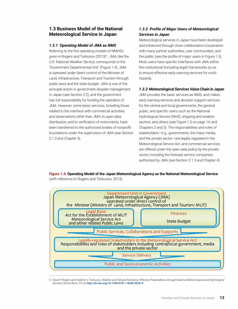
1.3.1 Operating Model of JMA as NMSReferring to the five operating models of NMHSs given in Rogers and Tsirkunov (2013)3 , JMA, like the U.S. National Weather Service, corresponds to the “Government Departmental Unit” (Figure 1.4). JMA is operated under direct control of the Minister of Land, Infrastructure, Transport and Tourism through public laws and the state budget. JMA is one of the principal actors in government disaster management in Japan (see Section 2.2), and the government has full responsibility for funding the operation of JMA. However, some basic services, including those related to the interface with commercial activities and observations other than JMA, to open data distribution, and to verification of instruments, have been transferred to the authorized bodies of nonprofit foundations under the supervision of JMA (see Section 2.1.3 and Chapter 4).
1.3.2 Profile of Major Users of Meteorological Services in JapanMeteorological services in Japan have been developed and enhanced through close collaboration/cooperation with many partner authorities, user communities, and the public (see the profile of major users in Figure 1.5). Most users have specific interfaces with JMA within the institutional (including legal) frameworks so as to ensure effective early warning services for multi-hazards.
1.3.3 Meteorological Services Value Chain in JapanJMA provides the basic services as NMS, and makes early warning services and decision support services for the central and local governments, the general public, and specific users such as the National Hydrological Service (NHS), shipping and aviation sectors, and others (see Figure 1.5 on page 14, and Chapters 2 and 3). The responsibilities and roles of stakeholders—e.g., governments, the mass media, and the private sector—are legally regulated in the Meteorological Service Act, and commercial services are offered under the open data policy by the private sector, including the forecast service companies authorized by JMA (see Section 2.1.3 and Chapter 4).
3 David P. Rogers and Vladimir V. Tsirkunov, Weather and Climate Resilience: Effective Preparedness through National Meteorological and Hydrological Services (World Bank, 2013), http://dx.doi.org/10.1596/978-1-4648-0026-9.
Figure 1.4: Operating Model of the Japan Meteorological Agency as the National Meteorological Service (with reference to Rogers and Tsirkunov, 2013)

14 Modernization of Meteorological Services in Japan
General and user-specific weather services, including early warnings by JMA, are delivered to users through various collaborating stakeholders in the central/local governments, the mass media, and the private sector, including authorized forecast service companies and mobile phone operators. Furthermore, the private sector provides the public and specific users with a wide variety of integrated services, such as value-added forecasting through the authorized forecast service companies, and services combined with other information related to security and other industrial/socio-economic activities (see Chapter 4).
1.4 Current Meteorological Services in Japan4
As the government authority, JMA collaborates with other relevant authorities to provide operational weather, climate, ocean-related, and terrestrial services through observation, monitoring, forecasts, and warnings in order to reduce the risks from the above-mentioned multiple natural hazards. The comprehensive multi-hazard approach taken by JMA (and the Japanese government broadly) to severe events related to weather, climate, environment, earthquakes, tsunami, and volcanic eruptions is the key strategy historically developed in Japan.
Figure 1.5: Institutional Relationships and User Communities in Meteorological Services in Japan
4 See Annex A1.2 for the organizational structure of JMA and its mission and services, A3.1 for the observation and information systems, and A1.3 for the list of information in weather services.

Weather and Climate Services in Japan 15
1.4.1 Information and Communication Network between JMA and Stakeholders/User CommunitiesThe backbone of the JMA’s operational meteorological services is a dedicated information and communication network called the Computer System for Meteorological Services (COSMETS). It is composed of a supercomputer system called the Numerical Analysis and Prediction System (NAPS) which employs NWP models and the Automated Data Editing and Switching System (ADESS). Furthermore, various comprehensive networks operated by JMA—for multi-hazard observation, monitoring, and warning systems—are built with the COSMETS as the central system.
The networks are connected for real-time communications with many stakeholders and user communities, including (1) central/local governments;
(2) aviation and shipping communities; (3) related institutes and universities; (4) the mass media and the private sector; (5) the general public; and (6) international communities of NMHSs, institutes, space agencies, etc. (see Figure 1.6)
Almost all the products, such as forecasts, warnings, and other information, are disseminated to users via the ADESS, which forms the basis of dissemination by a single authoritative voice in the comprehensive multi-hazard approach from the technical and system side.
1.4.2 Observation and Monitoring ServicesThe fundamental observations and monitoring networks of weather, climate, environment, earthquakes, and others were established and are maintained by JMA as the government authority; complementary observations are made by other
Figure 1.6: Comprehensive Networks of Information and Communications connected with Observation, Monitoring, Forecast, and Warning Systems for Multi-hazards in JMA and Communications with Authorities and User Communities (Original figure with eight photos cited from JMA, 2014)
Note: CAB = Civil Aviation Bureau; GMS = geostationary meteorological satellite; IOC = Intergovernmental Oceanographic Commission; JMBSC = Japan Meteorological Business Support Center; NHK = Japan Broadcasting Corporation.

16 Modernization of Meteorological Services in Japan
tsunami and volcanic eruptions) should be duly taken into account by governments developing effective and efficient countermeasures for the public (see Sections 2.1, 2.2 and 3.2).
1.4.3 Information Dissemination ServicesJMA provides the public and various socio-economic sectors with warnings and related information for disaster risk reduction (DRR) through various channels: (1) central government authorities (e.g., the Ministry of Land, Infrastructure, Transport and Tourism (MLIT), especially the Water and Disaster Management Bureau (National Hydrological Service of Japan), CAB, and JCG), the National Police Agency and the Fire and Disaster Management Agency; (2) local governments; (3) the Japan Broadcasting Corporation (NHK) and the Nippon Telegram and Telephone Corporation (NTT); (4) the private sector, including the mass media, via the Japan Meteorological Business Support Center (JMBSC) (see Section 4.2); and (5) JMA websites.
In disseminating information to the public and in ensuring enhanced utilization of information in various socio-economic sectors, the roles of the mass media and the private sector—including authorized forecast service companies—are crucial. The private sector shows its creativity in developing services that meet the growing needs of people’s daily lives, and in the evolution of ICT and socio-economic activities (see Sections 4.1, 4.3 and 4.4).
1.4.4 International Cooperation with WMO and Other International and Regional OrganizationsJMA’s commitment to international cooperation is seen in its operation of a number of global and regional centers established within the frameworks of the World Meteorological Organization (WMO), the Intergovernmental Oceanographic Commission (IOC) of the United Nations Educational, Scientific and Cultural Organization (UNESCO) and the International Civil Aviation Organization (ICAO) in a variety of fields of, among others: weather and climate observation, monitoring and prediction; communications and data processing; oceanographic observation; global
central/local governments, related institutes and universities, aviation and shipping sectors, etc. Various kinds of observational data are exchanged with these organizations and international communities so as to improve service delivery (see Sections 2.1.2 and 3.2.4).
Forecasting and Warning ServicesBased on the above networks, JMA provides forecasting and warning services for multi-hazards, including the following:
• Weather forecast services to the public and various socio-economic sectors;
• Early warning services for heavy rains, flood, storm, storm surge, high waves, snowstorm and heavy snows, and related advisories and information, including typhoon forecast to the public and the authorities responsible for disaster countermeasures;
• Aviation weather services to the Civil Aviation Bureau (CAB) and aviation communities;
• Maritime meteorological services to the Japan Coast Guard (JCG) and shipping communities;
• Climate and ocean forecast services, and monitoring services for the global environment to the public and related communities;
• Monitoring and warning services for earthquakes, tsunamis, and volcanic eruptions to the public and the authorities responsible for disaster countermeasures; and
• International cooperation and advisory services as the global and regional centers of UN/international organizations including those for Typhoon, tsunami, etc .
The importance of and the need for a single authoritative voice for warnings on severe natural phenomena (such as severe weather and climate, storm surges and ocean waves, earthquakes and

Weather and Climate Services in Japan 17
environment monitoring; tsunami monitoring and early warning; and aviation meteorological services. JMA provides geostationary meteorological satellite imagery to NMHSs in the Asia-Pacific region. Furthermore, JMA carries out various capacity development activities for NMHSs in developing countries through the projects implemented by WMO, the Japan International Cooperation Agency (JICA), and so on (see Chapter 5).
1.4.5 Research and Development, and Education and TrainingResearch and development and education and training are indispensable for the advancement of meteorological services with state-of-the-art science and technologies for observation, monitoring, and forecast. The MRI of JMA is the central and leading research facility for meteorological services in Japan. The Meteorological College is a key education and training institute of JMA that offers courses as a four-year college as well as various training programs for JMA technical staff members, and it has contributed to the development of higher-level human resources that in turn enabled modernization of meteorological services in Japan (see Section 2.3.2).
In the area of R&D, JMA through MRI has extensively collaborated and interacted with the academic community (research institutes, universities, etc.) to enhance knowledge, technology, and expertise and to improve the quality of services. These collaborations include joint research projects, data exchange (see Section 3.2.4), and establishment of coordination mechanisms (see Section 2.1.4).

18 Modernization of Meteorological Services in Japan
The evolution of meteorological services in Japan regulated in the Meteorological Service Act is summarized below, with an emphasis on institutional aspects. The Japan Meteorological Agency (JMA), as the National Meteorological Service (NMS), takes full responsibility for the sound development and provision of meteorological services in Japan as stated in the Act for Establishment of the Ministry of Land, Infrastructure, Transport and Tourism (MLIT).
2.1 Legal Framework
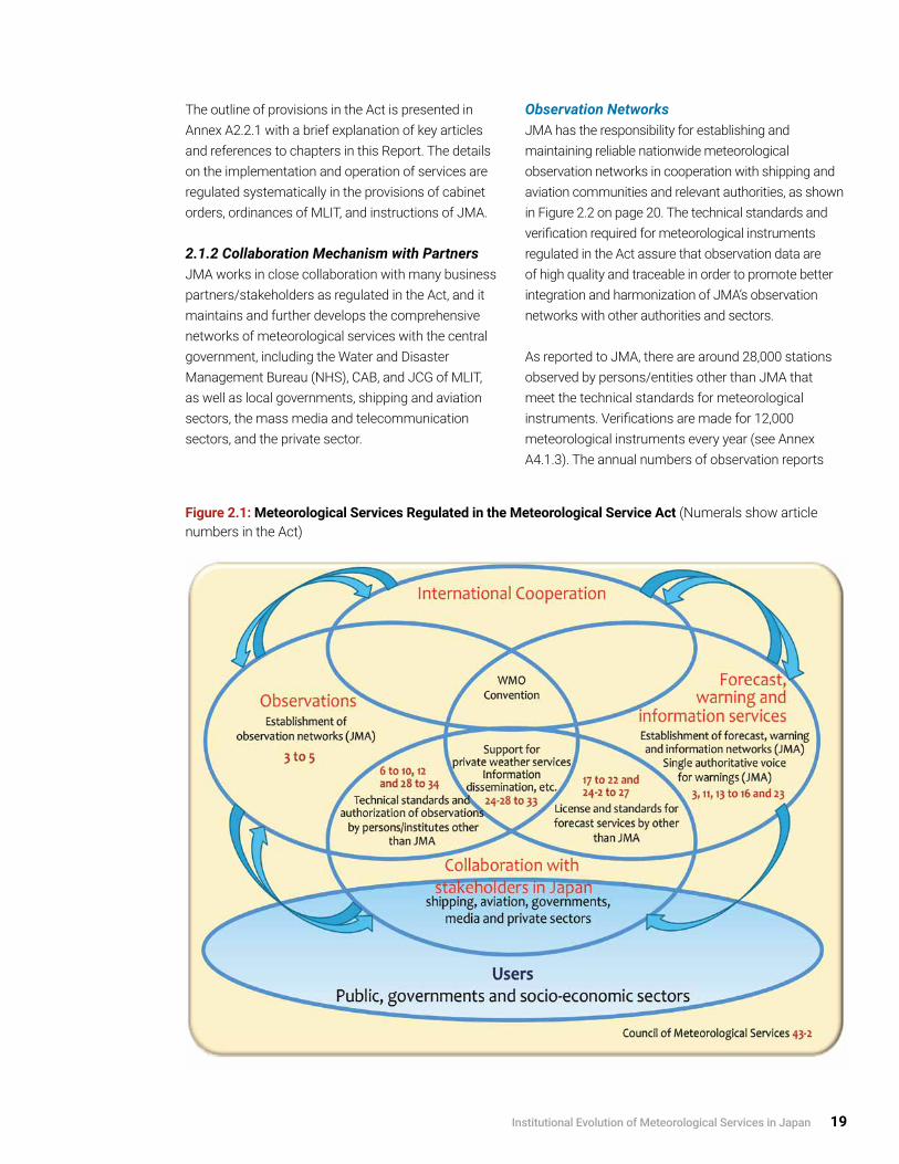
2.1.1 Meteorological Service ActThe Meteorological Service Act (hereafter referred to as the “Act”) was formulated in 1952 to establish the legal framework for meteorological services in Japan; the framework—schematically shown in Figure 2.1—has not been changed over 60 years and is still valid for today’s advanced information and communications technology (ICT) and diversified socio-economic activities. The Act defined meteorological services so as to cover atmospheric, hydrological, oceanic, and terrestrial phenomena, and it assigned JMA as NMS wider responsibilities than those for general weather, climate, and water services of NMHSs promoted under various programmes of WMO.
The Act comprehensively describes the following fundamental elements of meteorological services:
• Mission of JMA as the national authority for the sound development and provision of meteorological services in order to: (a) prevent and mitigate natural disaster; (b) secure safety of traffic; (c) contribute to the promotion of prosperity and welfare through the development of socio-economic activities; and (d) enhance international cooperation;
2. Institutional Evolution of Meteorological Services in Japan
• Mission of JMA as the national authority for the sound development and provision of meteorological services in order to (1) prevent and mitigate natural disaster; (2) secure safety of traffic; (3) contribute to the promotion of prosperity and welfare through the development of socio-economic activities; and (4) enhance international cooperation;
• Establishment and maintenance of observation, forecast, and information networks by JMA as the National Meteorological Service;
• Forecast and early warning services, including the dissemination of observation results and related information, and collaboration with the mass media for effective dissemination to the public;
• Issuance of warnings by JMA as the single authoritative voice for early warning services for severe weather, strong ground motions by earthquakes, tsunami, ocean waves, storm surges, and flood; and notification to the authorities of disaster countermeasures and to the public;
• Forecast and warning services for specific users such as flood management authorities, ships, and aircraft;
• Securing quality of observations by persons/entities other than JMA;
• Promotion of private meteorological services, including through the certified weather forecaster system; and
• Council of Meteorological Services (Council of Transport Policy, at present) for management and planning cycles .
Institutional Evolution of Meteorological Services in Japan 19
The outline of provisions in the Act is presented in Annex A2.2.1 with a brief explanation of key articles and references to chapters in this Report. The details on the implementation and operation of services are regulated systematically in the provisions of cabinet orders, ordinances of MLIT, and instructions of JMA.
2.1.2 Collaboration Mechanism with PartnersJMA works in close collaboration with many business partners/stakeholders as regulated in the Act, and it maintains and further develops the comprehensive networks of meteorological services with the central government, including the Water and Disaster Management Bureau (NHS), CAB, and JCG of MLIT, as well as local governments, shipping and aviation sectors, the mass media and telecommunication sectors, and the private sector.
Observation NetworksJMA has the responsibility for establishing and maintaining reliable nationwide meteorological observation networks in cooperation with shipping and aviation communities and relevant authorities, as shown in Figure 2.2 on page 20. The technical standards and verification required for meteorological instruments regulated in the Act assure that observation data are of high quality and traceable in order to promote better integration and harmonization of JMA’s observation networks with other authorities and sectors.
As reported to JMA, there are around 28,000 stations observed by persons/entities other than JMA that meet the technical standards for meteorological instruments. Verifications are made for 12,000 meteorological instruments every year (see Annex A4.1.3). The annual numbers of observation reports
Figure 2.1: Meteorological Services Regulated in the Meteorological Service Act (Numerals show article numbers in the Act)

20 Modernization of Meteorological Services in Japan
Note: Interfaces and interactions with relevant authorities and users are presented in Section 3.2
Figure 2.2: Legal Framework for Meteorological Observations (Underlines show articles in the Meteorological Service Act)
Figure 2.3: Legal Framework for Dissemination of Warnings under the Meteorological Service Act (Cited from JMA (2014) with some revision)

Institutional Evolution of Meteorological Services in Japan 21
from ships and aircraft to JMA are around 100,000 and 11,000, respectively. The data exchanges and impacts on service delivery are presented in Section 3.2.4.
Dissemination of WarningsUnder the Act, JMA is supposed to provide warnings to a number of authorities, including the National Police Agency, the Fire and Disaster Management Agency (included in 2013 with the introduction of the emergency warning system), prefectural governments, and the Nippon Telegraph and Telephone Corporation (NTT), and through them the mayors of municipalities (cities/towns/villages).
Finally, mayors of municipalities are supposed to endeavor to provide warnings to local public agencies and the public. Local governments have developed dedicated networks to disseminate information to the public for DRR. The Disaster Countermeasures Basic Act regulates the responsibilities of mayors for the official countermeasures and for issuing the official advice/order of evacuation to the public.
In addition to these governmental routes, JMA is supposed to provide warnings to the Japan Broadcasting Corporation (NHK), which should immediately broadcast the warnings to the public. Private mass media and authorized forecast service companies also play significant roles in warning dissemination. These multiple routes ensure a highly reliable system of warning dissemination for end-users.
JMA issues specific warnings for specific uses (e.g., flood management, shipping, and aviation). JMA is supposed to provide warning for flood management to the Water and Disaster Management Bureau of MLIT and prefectural governments, and notifies CAB to deliver warnings to aircraft and JCG of MLIT to deliver warnings to ships.
Figure 2.3 summarizes the dissemination flow of warnings from JMA to the public through the relevant authorities.
2.1.3 Major Amendments to the Act5
Since its establishment in 1952, the Act has been partially amended on several occasions in order to meet emerging societal needs. Major amendments to the Act were made in the following areas:
Introduction of Early Warning System for Earthquakes and Volcanic EruptionsIn 1978, the Act on Special Measures for the Intensified Observation Areas of Earthquakes (such as the Tokai region) was established. It calls for JMA to report “information concerning prediction of a potential earthquake (including a potential tsunami)” in the Tokai region to the prime minister for government countermeasures. Further, in 2007, with advances in monitoring/prediction techniques, forecasts and warnings for “strong ground motions by earthquakes (Earthquake Early Warning System)” and “volcanic phenomenon (eruptions and ash)” were introduced; ever since, licensing and standards for forecast services for those phenomena by persons/entities other than JMA have also been regulated to allow private forecasts. These amendments have enhanced the institutional and technical capability of JMA’s multi-hazard approach.
Enhancement of Public-Private Partnership (PPP)In 1993, responding to a rapid expansion of the activities in the private sector, including authorized forecast service companies, and to the need for their specific utilization of meteorological information issued by JMA, such as NWP data, products, analysis, and forecasts, the institutional frameworks of the “private meteorological service support center” and the “certified weather forecaster system” were established. The center supports the weather business in the private sector through distribution of various data and products from JMA, as well as counseling, research, and so on. The verification of meteorological instruments was institutionally transferred from JMA to an authorized body in 2002.
The Japan Meteorological Business Support Center (JMBSC) was designated as the authorized body for the “private meteorological service support center”
5 See Annex A2.2.2 for the list of amendments to the Act.

22 Modernization of Meteorological Services in Japan
and also given responsibility for implementing the national examination for certified weather forecasters and verifying meteorological instruments. The above framework assures the quality of forecast services and observations by the private sector and others. The activity of JMBSC is summarized in Section 4.2.
Introduction of Emergency Warning SystemIn 2013, JMA introduced a system of emergency warnings to enhance services related to risk-based warnings for catastrophic events. JMA issues emergency warnings to alert people to the significant likelihood of catastrophes arising from natural phenomena of extraordinary magnitude, such as the 2011 Great East Japan Earthquake and the heavy rains induced by Typhoon Talas in 2011. Mayors take immediate action to provide JMA’s emergency warnings to the public in their respective municipalities.
2.1.4 Policy-making and Coordination Mechanisms in Meteorological Services6
Management and planning cycles, including assessment and verification of services, are an
indispensable part of the effort to modernize services and improve systems, warnings, and other services in order to meet growing socio-economic needs and requirements and to strengthen the activities for DRR and services to socio-economic activities. Typical user interfaces in the process of continuous assessment of JMA services are as follows:
• Establishment of policies, and continuous assessment of the quality of products and services and their improvement, with the guidance of the Subcommittee of Meteorology in the Council for Transport Policy and associated committees, meetings, and working groups of relevant authorities and experts; and
• Assessment of the utilization of and user satisfaction with meteorological services, including daily weather forecasts (see details in Section 3.4).
In the multi-hazard approach to weather-related severe events (summarized in Section 3.2), meteorological
6 See Annex A2.3 for the list of policy-making and coordination mechanisms.
Figure 2.4: Improvement of Early Warning Services through Management and Planning Cycles with Assessment and Verification

Institutional Evolution of Meteorological Services in Japan 23
services for socio-economic activities (see Section 3.3 and Chapter 4) have evolved with the development of socio-economic activities and associated vulnerabilities in Japan. In particular, experiences and lessons learned from devastating disasters have provided opportunities to improve service delivery and collaboration with authorities and the public.
In the last decade, special attention has been paid to the improvement of early warning services. Drawing on advances in monitoring and prediction techniques, specific bulletins on hazardous winds, heat waves, and climatic extremes have been introduced to cope with the emerging hazards. Many of these services have been improved and introduced through the established coordination and cooperation mechanism with stakeholders, including central and local governments, the mass media, the private sector, and research institutes and universities (see Figure 2.4). The management cycle in modernization processes is described in Section 3.1 and illustrated in Figure 3.1.
Through the investigations by JMA itself with the Council and expert bodies, as well as the integrated investigations on government countermeasures under the Cabinet Office following devastating natural
disasters, meteorological information has been considerably improved. This information includes warnings/alerts for tsunami, volcanic eruptions, floods and landslides, tornadoes, heavy snows, etc., together with multi-sectoral disaster countermeasures.
The above management, planning, and assessment mechanisms also function more broadly for coordination and cooperation with stakeholders.
2.2 Roles and Responsibilities of JMA within the Framework of Government Disaster Countermeasures
2.2.1 Structure of JMAJMA is an extra-ministerial bureau of the Ministry of Land, Infrastructure, Transport and Tourism, responsible for early warning services as the national authority, and is composed of its headquarters (HQ), six regional HQs, 50 local meteorological offices (LMOs), two weather offices, 10 aviation weather service centers/stations, and five auxiliary organs (see Figure 2.5 and Annex A1.2). The JMA HQ serves as the administrative and operational center of the agency and is under the direction of a director-general, deputy director-general, and five departments (Administration;
Figure 2.5: JMA Main Offices (Cited from JMA website)

24 Modernization of Meteorological Services in Japan
Forecast; Observation; Seismology and Volcanology; and Global Environment and Marine). The regional HQs serve as regional central offices guiding LMOs, which provide forecast and early warning services at prefectural and subprefectural levels.
The JMA HQ, regional HQs, and LMOs are basically placed and operated in accordance with the structure and responsibility of central/local governments, and LMOs collaborate with respective prefectural governments. Each LMO (with around 30 staff members, of whom over 90% are professional) provides observation, monitoring, forecast, and warning services on a 24/7 basis; promotes activities to strengthen the linkages with local government authorities and the mass media; and works to raise awareness among the public and students. The observation sites are controlled and monitored by the centralized systems of the JMA HQ and Osaka Regional HQ, but regular inspection and recovery from system damage are carried out by the LMO technical staff for sustainable observations (see Section 3.1).
A total of four aviation weather service centers and six aviation weather stations are located at major airports and provide support for the aviation service community, including CAB of MLIT.
2.2.2 Disaster Countermeasures of the Government and JMAThe Japanese government employs an advanced systematic institutional framework to prevent, mitigate, and prepare for natural disasters. The government’s disaster management is comprehensively regulated in the Disaster Countermeasures Basic Act enacted in 1961 after the tragic disaster caused by Typhoon Vera (T5915). The Basic Act has been amended successively with other related laws, in accordance with the experiences of severe natural disasters and the development of science and technology and socio-economic activities. Within the framework of the government disaster countermeasures, JMA plays a key role in providing the latest information about, as well as forecasts and warnings for, severe natural phenomena (as shown in Figure 2.6).
Figure 2.6: Disaster Management Operation Schemes and Roles of JMA (Cited from JMA website with some revision)

Institutional Evolution of Meteorological Services in Japan 25
A number of acts related to disaster countermeasures and safety reference specific meteorological services, as in the following:
• Special measures on severe damage by (1) typhoons and heavy rains (floods, landslides, etc .), (2) heavy snows, (3) earthquakes, and (4) volcanic eruptions;
• Safety of transport relating to (5) traffic, (6) shipping, and (7) aviation; and
• Protection of the environment relating to (8) global environment (ozone layer and climate change), (9) air and marine pollutions, and (10) fire.
These acts either give JMA direct responsibility for observations, data collection, and alerts for disaster risk reduction, including warnings and others, or they give JMA shared responsibility with governments. They also establish the institutional foundation for the multi-hazard approach (see also Annex A2.2.3).
Based on the Basic Act and related regulations, central/local governments formulate the implementation and operating plans for disaster countermeasures, and a number of emergency drills are carried out every year by all communities under central/local governments and by the private and public sectors.
When a disaster occurs (or is likely to occur), the central and local governments establish the “Disaster Management HQs” under the Basic Act, and the central government establishes “Local HQs” and/or “Local Liaison Disaster Response Offices” to support local governments. The JMA HQ, regional HQs, and LMOs dispatch experts to provide the latest meteorological information (such as forecasts) and associated advice for appropriate countermeasures.
2.2.3 Integration of Government Countermeasures for Disaster Risk Reduction In 2001, as part of the reform of the central government system, the government countermeasures for DRR were strengthened by the establishment of the minister of state for disaster management and of the Cabinet Secretariat; the goal was to integrate and better coordinate DRR policies and activities of all the ministries and agencies concerned (see Annex A1.2.1). Within this framework, the roles and responsibilities of JMA as NMS have been gradually enhanced year by year through experiences of successive disasters.
Under the Central Disaster Management Council chaired by the prime minister, various kinds of DRR activities are carried out. As NMS, JMA takes part in these so as to provide early warning services for multi-hazards and improve its services through collaborative efforts (see Hasegawa et al. (2012) and Cabinet Office (2015)7 for the outline of Japan’s disaster management system, including disaster preparedness and response).
In 2001, when a number of government ministries were integrated, there was a merger of the Ministry of Transport (of which JMA was part) and the Ministry of Construction (of which NHS—i.e., the River Bureau at that time—was part); the resulting ministry was MLIT. This integration enhanced multi-sectoral collaborations in disaster management. MLIT has today a wide variety of departments related to disaster management and safety, including floods, roads, ports and harbors, civil aviation, maritime transport, railways, road transport, housing, tourism, etc., and JMA has promoted collaboration with many bureaus of MLIT in the relevant fields, such as for countermeasures against earthquakes and tsunami, volcanic eruptions, typhoons and heavy rains, strong gusts (tornadoes), heavy snows, etc.
7 Hasegawa, S. Harada, S. Tanaka, S. Ogawa, A. Goto, Y. Sasagawa, and N. Washitake, “Multi-Hazard Early Warning System in Japan,” in Institutional Partnerships in Multi-Hazard Early Warning Systems, ed. Maryam Golnaraghi (Springer, 2012), 81–215; Cabinet Office, “Disaster Management in Japan” (brochure in Japanese and English), (Cabinet Office, 2015), http://www.bousai.go.jp/1info/pdf/saigaipamphlet_je.pdf.

26 Modernization of Meteorological Services in Japan
2.3 Budget, Staffing, and Human Resources Development
2.3.1 Budget and Staffing of JMAThe annual budget of JMA in FY2015 was 58.7 billion yen (about US$550 million) for general services and 12.8 billion yen (US$120 million) for aviation weather services. About 12% of the general services budget was for the operation of meteorological satellites and 60% for personnel. The funding level was 0.013% of Japan’s gross domestic product.
Under the governmental budget restraint, the annual regular budget has been gradually decreased in many of the government authorities, including JMA, but the supplementary budgets have been compiled to enhance the government disaster countermeasures following the experiences of severe natural disasters. The annual budget of JMA from FY2000 to FY2015 is shown in Figure 2.7.
The number of JMA staff in FY2015 was 5,167, of whom roughly 90% were professional staff and 10% general staff. Like the budget, the number of staff members has been gradually decreased; it was 17% less during the last 20 years under the government
Figure 2.7: Annual Budget of JMA from 2000 to 2015 (Fiscal Year: April–March) (Based on the data provided by JMA)
reform. The majority of professional staff employed in the last three decades, and almost all employed in the last decade through the national examination for government officials, have a bachelor’s or more advanced degree. Furthermore, JMA offers medium- and long-term training programs to its staff to enhance their capabilities, as described in detail in Section 2.3.2.
In spite of the decreasing financial environment of the government, JMA has strengthened service delivery to users by modernizing systems and mobilizing human resources so they meet the growing needs for DRR and global environmental issues, as described in Chapter 3. It should be underlined that the high education level of JMA employees facilitated the sustainable human resources development.
2.3.2 Development of Human Resources in JMAHuman resources with advanced knowledge of science and technology are the most important asset for NMHSs in the development and operation of various observation and forecasting systems and services. JMA has made its long-term efforts in sustainable human resources development in order to realize modernization. The establishment of a dedicated training course goes back to 1897, while

the predecessor of the Meteorological College was established in 1922, more than 90 years ago.
Since those early days, JMA and the Meteorological College have continued to conduct systematic training courses for technical and management staff. The four-year college course has provided the highest level of meteorological education to (around 15) young members every year, with the goal of having they play a leading role in operational JMA services as senior professional staff. In addition, all JMA staff members, including LMO staff, receive step-by-step training. The training courses include the general technical services from entry to senior professional levels, and the specialized services for each area of expertise, such as weather observation and forecast, earthquake and tsunami monitoring, climate and ocean monitoring,
ICT, etc. The training courses are mainly given at the Meteorological College, and complementarily at regional HQs as well as by correspondence. Typically, forecasters take part in five specific training courses of three to seven weeks at the Meteorological College, along with a five-month correspondence course, several short training courses at regional HQs, and on-the-job-training in their offices.
These long-term efforts in sustainable human resources development within JMA have led to JMA’s modernization, including the introduction of the first operational weather radar in 1954, development of NWP models in 1959, the launch of the geostationary meteorological satellite (GMS) in 1977, and recent further advances in systems and service delivery.
Box 2.1 Socio-economic Benefits and Meteorological Services in Japan
The benefits of weather and climate services and the impact of weather and climate variabilities are very well recognized by the general public and also by a wide range of socio-economic sectors, e.g., agriculture, forestry, fishery, transport, manufacturing and energy, and human health and welfare. Thus the Japanese government, including JMA, has continuously strengthened its extensive meteorological services, in particular disaster countermeasures and related services, in response to harsh experiences with severe natural disasters.
The costs of economic damage caused by natural disasters (e.g., earthquakes, tsunami, and severe weather and climate events) are estimated and tabulated by relevant government authorities to facilitate effective measures for recovery and reconstruction. The estimated annual amount of economic damage is normally several hundred billion yen (several billion U.S. dollars) but was several trillion yen (tens of billions of U.S. dollars) in 2011 due to the Great East Japan Earthquake that year. Recently, social damage from heatstroke has increased during the summer; the number of casualties is tabulated by the Fire and Disaster Management Agency every week to maximize public awareness about its severity. See also Annex A1.1 concerning climate and natural disasters in Japan.
Japanese society is highly conscious of weather conditions and natural hazards, so there is strong public support for meteorological services; this support, coupled with substantial societal needs for DRR for protection of life and property, has resulted in successive strengthening of the extensive meteorological services provided by JMA, the government, and the mass media (see Chapter 3). Utilization of meteorological data and information by both the public and industry has also quickly expanded with recent rapid advances in and spread of ICT (see Chapter 4).
Analysis of the socio-economic benefits of improved meteorological services has not necessarily been a direct driver of those improvements in Japan. The socio-economic benefits of meteorological services have not yet been well studied quantitatively or comprehensively, and the valuation has been limited to the specific services such as weather routings of ships and others (see Box 4.3 for specific weather services).
Institutional Evolution of Meteorological Services in Japan 27

Box 2.2 Human Resources Development in JMA: Education and Training Courses for Technical and Management Staff
EmploymentThe JMA professional staff are employed through the national examination for government officials as either:
• For four-year college courses (around 15); or
• Graduates with bachelor’s or more advanced degree (mainly in science and technology, such as geophysics, physics, ICT, etc .) .
Training CoursesThe Meteorological College (Photo 2.1) is a JMA education and training institute offering a four-year college course and various training programs. The four-year college course for professional staff provides the highest level of scientific knowledge in geophysics, including meteorology and seismology, as well as basic science and technology. The training programs comprise a number of step-by-step courses at the Meteorological College as well as at regional HQs, by correspondence, and through on-the-job training at respective offices, as schematically illustrated in Figure 2.8.
Figure 2.8: Systematic Training Courses for Professional Staff of LMOs at the Meteorological College (Based on the diagram provided by JMA)
Photo 2.1: Meteorological College in Kashiwa City. (20 km northeast of Tokyo) (Cited from JMA website)
28 Review of Meteorological Services In Japan

Modernization of Observation and Forecasting Systems and Service Delivery in Japan 29
In this chapter, modernization of JMA’s operational systems and associated service delivery is reviewed in detail, including the telecommunication and data processing systems, surface weather observation network, weather radars, NWP, and forecasting systems. Generally, the modernization of systems has led to more accurate analysis and forecasts with higher spatial and time resolutions.
3.1 Modernization of JMA Operational Systems and Improvement of Services
3.1.1 General Description
Modernization through Long-term Sustainable EffortsAs stated in Section 1.2, the modernization of JMA’s operational observation and telecommunication systems has been achieved through strategic investments to improve service delivery, through effective human resources mobilization to address growing societal needs, particularly for DRR, and through a four-stage improvement over a period of 60 years, as shown in Table 1.1. For instance, gradual increases in accuracy and precision in daily forecasts and typhoon forecasts, as shown in Figures 3.4 and 3.5, are typical cases highlighting the importance of long-term sustainable efforts in scientific/technical research and development.
Building on the foundation of the long-term and sustainable human resources development (described in Section 2.3.2), JMA entered into the era of challenging environment for investments in modernization (first and second stages) and established the nationwide modern networks incorporated into the international networks of WMO, UNESCO/IOC, and ICAO, which led to the current advanced networks and fruitful improvement of service delivery (third stage and present fourth stage).
The societal needs for precise and accurate meteorological services have expanded as a result of successive devastating natural disasters and changes in and development of socio-economic structures and activities. Even today, user requirements for timely and effective early warning services continue to increase on account of recent unprecedented natural disasters.
Strategic Management and Planning Cycles to Enhance Service DeliveryThe outcomes of modernization have not been limited to the efficient and effective operation of observation and information systems. The totality of planning and management have been directed at improvement of service delivery (real-time products) to end-users and at the best utilization of human resources to meet emerging societal needs for DRR (see Figure 3.1 on page 30). The mechanisms include the Council of Transport Policy (the former Council of Meteorological Services) regulated in the Act, commissions, and related technical working groups with experts and stakeholders, including central and local governments, the media, and the private sector. Current management and planning cycles with assessment and verification of services are described in Section 2.1.4 and Annex A2.3.
The Council of Meteorological Services initiated its activities in 1956 and provided many reports on the basic strategies as the NMS to the director-general of JMA. Based on these reports, JMA established a comprehensive strategic program, called the National Weather Watch (NWW) programme, in the 1970s, following the World Weather Watch programme of WMO. Its goal was to define the medium- and long-term strategies for observation/monitoring, telecommunication, and data-processing and forecasting systems. All the systems and services related to weather and climate were historically modernized under the NWW programme and others,
3. Modernization of Observation and Forecasting Systems and Service Delivery in Japan

30 Modernization of Meteorological Services in Japan
and the finer spatial and temporal resolutions of product and the more accurate and timely provision of early warning services were realized successively.
Human resources have been mobilized, year by year, along with government reform in the JMA HQ, regional HQs, and LMOs for growing and diversifying needs, such as the following:
• Monitoring and warning services for severe weather events;
• Monitoring and warning services for earthquakes, tsunami, and volcanic eruptions;
• Enhancement of the collaboration and linkage with local governments/authorities and the public for DRR; and
• Monitoring and prediction of changes in the global environment and climate, including oceans .
3.1.2 Policy on the System Development and Operation for Quality Assurance of Service Delivery in JMA
System Development and Crisis ManagementThe Government of Japan and Japan’s society have developed sound crisis-management systems to cope with frequent devastating natural disasters. As a key actor in managing crises for the government, JMA is required to issue early warnings to government authorities and the public on a 24/7 basis. Warnings and earthquake information are transmitted to the authorities through dedicated communication networks, broadcasted by TV/radio, and disseminated by mobile phones and other devices within seconds after issuance by JMA.
Figure 3.1: Modernization of Operational Systems and Service Delivery based on User Needs, with Management and Planning Processes and their Cycles

Modernization of Observation and Forecasting Systems and Service Delivery in Japan 31
JMA has also developed highly redundant systems in order to ensure sound operation in the event of power failure or malfunctions of/accidents to communication networks. Based on the latest observation and information technology, the observation and information systems covering the whole of Japan have been automated. They are remotely controlled/monitored centrally through the step-by-step processes at the JMA HQ, with the geographically redundant systems (including computer systems) at Osaka and/or Fukuoka regional HQs. Because of these sound crisis-management systems, there has been no disruption in real-time early warning services in the last decade.
System Integration and Management by JMA in Development and Operation ProcessesIn developing observation and information systems, such as the COSMETS, AMeDAS (the high-resolution automatic surface weather observation network), the weather radar network, and others (see details in Annexes A3.1 and A3.2), JMA technical experts
develop the required specifications documents based on state-of-the-art technology, and they supervise the manufacturers of instruments and ICT systems throughout the processes of development and operation. This approach enables comprehensive and effective system integration and management by JMA.
In this respect, JMA operates the Meteorological Instrument Center (MIC) to verify the instruments operated by JMA as well as by persons/entities other than JMA. MIC also has international responsibility for serving as a Regional Instrument Centre (RIC) of WMO to assist Asian NMHSs in calibrating their national meteorological standards and instruments (see Annex 5.2.2 for its activities).
Maintenance of On-site Instruments and Quality AssuranceMaintenance and recovery of on-site observation instruments are indispensable for realizing better observation, monitoring, forecast and warning services. Besides the operation of monitoring systems, JMA has made significant long-term efforts in maintenance (daily remote maintenance from the centers and on-site inspections by LMOs) and in quick recovery by LMOs when the sites encounter accidents.
The rate of successful observations by JMA reaches its highest level of 99.8% in AMeDAS and the weather radars; this type of performance has been typical for all the observation systems in JMA for a long time. These efforts assure the highest quality and reliability for all JMA’s service delivery.
Monitoring, Forecast, and Warning Services in the Responsible OfficesUsing sound observation and information systems, professional staff (including forecasters) monitor changes in meteorological conditions, analyze/assess the observed and processed data (including NWPs and other guidance materials), and issue forecasts, warnings, and related bulletins on a 24/7 basis. Those warnings/advisories/bulletins are issued systematically by the responsible HQs and LMOs as regulated in the institutional provisions.
Photo 3.2 : Real-time Monitoring and Analysis of Severe Weather Events and Issuance of Forecasts and Warnings. (Operations by forecasters to issue forecasts and warnings, and briefing and conference on the assessments of weather conditions with the directive by the chief forecaster) (Cited from JMA (2014))

Box 3.1 Recovery Efforts and Enhancement of AMeDAS Stations after the 2011 Great East Japan Earthquake
The AMeDAS system, with around 1,300 automatic weather stations (AWSs), is controlled and monitored at the JMA HQ by the centralized system, while LMOs make regular inspections on site and handle emergency recovery efforts to resolve malfunctions.
In the 2011 Great East Japan Earthquake, many weather observations from AMeDAS stations in northern Japan were suspended due to tsunami damage, network failure, and power outages. As a result of restoration work by LMOs (see Photo 3.1 and Figure 3.2), however, 80% of the stations resumed operation within three days, 90% within a week, and 99% within one month. Two weather radars in the region (at Akita and Sendai) also stopped operation immediately after the earthquake, but both resumed operation by the next day after emergency inspections.
Furthermore, to enhance weather services for recovery and restoration efforts by the relevant authorities, a total of nine stations were temporarily set up at the disaster-stricken vulnerable areas along the northern Pacific coast before the rainy season.
Figure 3.2: Available AMeDAS Stations in Northern Japan Immediately after the 2011 Great East Japan Earthquake. (The number of AMeDAS stations in northern Japan is about 450.) (Cited from JMA website with English translation)
After the earthquake, on 23 March 2011
At Onahama (Fukushima), the raingauge severely damaged by the tsunami was replaced with new equipment immediately after the tsunami disaster .
Photo 3.1: AMeDAS Station Damaged by Tsunami (top) and Recovery Efforts (bottom).(Cited from JMA website)
32 Review of Meteorological Services In Japan

Modernization of Observation and Forecasting Systems and Service Delivery in Japan 33
The HQs and offices responsible for early warning services are as follows:
• Nationwide monitoring and forecast by the JMA HQ (e .g ., typhoon forecast) for weather-related early warning services . LMOs are supervised in real time by the JMA HQ and regional HQs through directive bulletins and videoconferencing (see Photo 3 .2 on page 31);
• Monitoring, forecasts, and warnings for severe weather and associated floods, storm surges, and high waves, as well as collaborations with local governments and authorities, by LMO;
• Monitoring, forecasts, and warnings for volcanic activities by the JMA HQ and regional HQs; and
• Monitoring, forecasts, and warnings for earthquakes and tsunami by the JMA HQ and the redundant center at Osaka Regional HQ .
Long-term Data Archive and Database DevelopmentJMA has historically made extensive efforts to archive observed original data in paper form and with photographic copies, and it has established digitized databases for an observation period of over 110 years. After the 1980s, the database management system was established as the information/data foundation, and it has contributed to the adequate understanding of climate change and variability and of natural hazards in Japan, and to the modernization of service delivery, including early warnings. For example, the AMeDAS database on rainfall over a period of 40 years clearly shows the increasing tendency of short-period torrential rains (over 50 mm per hour), which reveals an increase in vulnerabilities to torrential rains (see Figure 3.3). Radar/Rain gauge–Analyzed Precipitation data with 5-km resolution for all of Japan have been archived over 25 years; this archive provides the data foundations for early warning services based on the quantitative criteria for respective municipalities (see Section 3.1.4 and Annex A3.6).
Figure 3.3: Increasing Tendency of Torrential Rains Observed by the AMeDAS (Based on the data in JMA (2015))

34 Modernization of Meteorological Services in Japan
3.1.3 Evolution of Meteorological Equipment IndustryIn the 1920s, the Central Meteorological Observatory (CMO, predecessor of JMA) established the Meteorological Instrument Factory within CMO to manufacture meteorological instruments. Then private manufacturers gradually came on the scene, and the Japan Association of Meteorological Instrument Engineering (JAMIE) was established by 10 founding corporations in 1953. This was one year after the formulation of the Meteorological Service Act, which defines the observations by persons/entities other than JMA and the standards for verification of instruments (see Section 2.1).
With the growth of instrument corporations, manufacturing of many JMA instruments has been outsourced to private manufacturers; this takes place under JMA’s total management of system development and its verification/examination of instruments for sound observation, resilience to severe weather, and long-term sustainability with high quality. This arrangement has resulted in the enhancement of observation technologies/techniques for both JMA and manufacturers through their interaction. With JMA’s pertinent supervision and effective guidance and manufacturers’ sincere responses, Japan’s instrument industry has produced a variety of high-grade meteorological instruments.
Those making use of the instrument industry have gradually expanded to include central and local government authorities as well as the private sector; this expansion is a result of the growing need for weather and environment monitoring/assessment in the management of social infrastructures and public services, etc., as socio-economic activities have intensified. In recent years, with advances in ICT, system integration of meteorological equipment (sensors and electronic data processors) and networking have become more important. In this context, the strength of the meteorological equipment industry in Japan is attributed to the existence of high-tech electronic equipment manufacturers, which easily facilitate a harmonized system of integration and networking.
Today, there are around 40 meteorological instrument/equipment companies in Japan. Some of them have contributed to international cooperation activities in collaboration with JMA and have experienced certain difficulties in implementing projects because of inappropriate system design, development, integration, and networking. To avoid such difficulties, high-quality meteorological instruments and equipment must be introduced in an integrated manner and with strong supervision by the appropriate system integrator (see also Section 5.4 for experiences in JICA projects).
3.1.4 Modernization in Service Delivery Related to Severe WeatherThis section focuses on the modernization of service delivery with reference to the accuracy/performance of typhoon forecasts, daily weather forecasts, and early warning services for severe weather.
Improvement of Typhoon Forecasts and Daily Weather ForecastsTyphoons are the most disastrous severe weather events in the northwestern Pacific region, which includes Japan; thus the accurate prediction of their locations and intensities has always been a vital challenge for JMA. Based on the comprehensive advancement of observation, monitoring, and forecast techniques (described in the former sections), the accuracy of predictions has been improved year by year, as shown in Figure 3.4, and led to the issuance of five-day track forecasts in 2009. It took around 60 years to reach this stage; 24-hour through 48-hour track forecasts became available in 1989; and 72-hour track forecasts became available in 1997 (see Annex A3.5.1).
For 30 years, JMA has carried out verifications of daily forecasts of precipitation and temperature and has disclosed the results to the public. The accuracy has been improved step by step, and the accuracy of precipitation/non-precipitation forecasts for the following day is now at 87% in Tokyo (Figure 3.5).
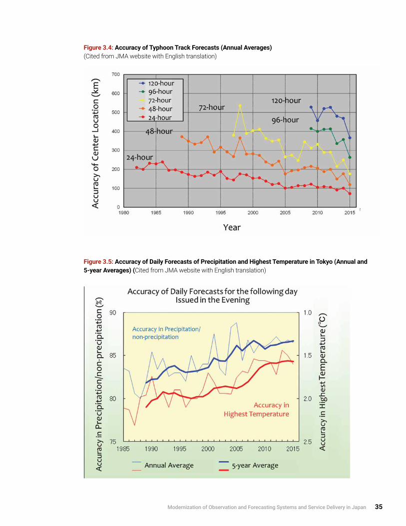
Modernization of Observation and Forecasting Systems and Service Delivery in Japan 35
Figure 3.4: Accuracy of Typhoon Track Forecasts (Annual Averages) (Cited from JMA website with English translation)
Figure 3.5: Accuracy of Daily Forecasts of Precipitation and Highest Temperature in Tokyo (Annual and 5-year Averages) (Cited from JMA website with English translation)

36 Modernization of Meteorological Services in Japan
Enhancement of Risk-based Early Warning ServicesHistorical EvolutionThe initiation of warning services by JMA dates back to 1883, when the Tokyo Meteorological Observatory issued storm warnings for the whole area of Japan. In 1934, after a strong tropical cyclone left thousands of casualties, the Central Meteorological Observatory introduced two levels of warning services (warning and advisory); 10 geographical service target areas were created in the next year.
The comprehensive framework of early warning services for multi-hazards, including the legal framework by the Meteorological Service Act (see Section 2.1), was established in 1950–1953. Service areas were divided into around 90 sections at the prefecture level, corresponding to the responsibility of disaster countermeasures in local governments. At the same time, LMOs introduced quantitative criteria for issuing warnings/advisories based on wind speed, 24-hour precipitation amounts, and 24-hour snowfall amounts. In the 1970s, based on investigations into the relations between precipitation amounts and disasters, one- and three-hour short-range precipitation amounts were introduced into the criteria for detecting the potential impacts of heavy rains. The AMeDAS system was put into operation in 1974.Risk-based Warnings and Collaborations with Local GovernmentsOperational use of the Quantitative Precipitation Estimation (QPE)/Quantitative Precipitation Forecast (QPF) techniques began in 1994 (see Section 3.2.4); these give spatially homogeneous and fine-gridded data. Two indices that show the potential risks of landslides8 and flooding/inundation—a soil-water index and a run-off index—were developed and used as part of the criteria for heavy rain and flood warnings through 2008. The criteria are determined quantitatively by thresholds based on the database of indices, hourly precipitation, and the occurrence of disasters. LMOs consult with local governments about the draft criteria
for effective early warning services. In the emergency warning system introduced in 2013, the coordination mechanism for the criteria was regulated in the Meteorological Service Act. After disaster events, LMOs generally investigate issued alerts and the actions taken by stakeholders, including local governments, in order to improve operations in the future.
Based on the above quantitative criteria, the areas in warning services were subdivided at the municipality level to enhance the effectiveness of warnings as part of DRR activities for mayors and residents. The number of service areas reached around 1,800 in 2010 (see Annex A3.6).
At the same time, as part of collaborative services with the prefectural governments, flood warnings for specific rivers under the prefecture’s control were introduced in 2002, and Landslide Alert Information was introduced in 2005 (see Section 3.2.5). The alert information is issued when heavy rain warnings are issued and there is a high likelihood of landslides within a few hours.Modernization of Operating Systems for ForecastersThe COSMETS, composed of the ADESS and the NAPS, has provided JMA forecasters with high-performance data. As COSMETS has modernized, there have also been advances in the man-machine interactive tools that monitor/analyze/assess weather conditions at LMOs, which issue municipality-level warnings based on the nation-wide quantitative criteria for issuance.
8 The term “landslides” is used hereafter to refer to debris flows and concentrated slope failures.

Box 3.2 Criteria of Risk-based Warning in JMA
Climate and geography vary greatly from region to region. For instance, daily maximum precipitation of around 1,000 mm is frequently recorded in southern Japan during the typhoon and rainy monsoon season, compared to 200 or 300 mm in northern Japan. Consequently, weather-related vulnerability and risk are quite region-specific and not dependent on the absolute amount of precipitation (the same applies to other weather elements).
In light of the variations in vulnerability and risk by region, JMA has developed municipality-specific criteria for warnings and advisories, using quantitative thresholds in referring to weather conditions and the past occurrence of disasters for each municipality. For example:
1 . The soil-water index and run-off index were developed to evaluate potential risks of landslides, inundation, and flooding (see Annex A3.6.3), and are used in developing criteria for heavy rain and flood warnings (Figure 3 .6 on page 38) .
2 . Concerning heavy snow, vulnerability and risk associated with climate are quite different for the areas along the Sea of Japan and the Pacific Ocean. Quantitative criteria for snowfall depth are therefore set in comparison with the past damage to traffic and houses.
3 . Given regional difference in climate and geography and the associated countermeasures, including breakwaters, in the Pacific Ocean side versus along the Sea of Japan and inland seas, the quantitative criteria for wave height and tidal level are set based on past disasters and observed records .
Accordingly, LMOs set the criteria for each municipality in cooperation with the local governments concerned (see an example in Table 3.1).
Table 3.1: Criteria for Warnings for the South of Shizuoka City (150 km east of Tokyo) (Provided by JMA)
* The term “landslides” here refers to debris flows and concentrated slope failures.
Modernization of Observation and Forecasting Systems and Service Delivery in Japan 37
Continues on next page.

Box 3.2 Criteria of Risk-based Warning in JMA (continued)
Figure 3.6 : Example of Setting Criteria for Inundation using a Scatter Diagram of Past Disasters on a Plane of 1-hour Precipitation Amount (y-axis) and Run-off Index (x-axis). (Criteria are determined by the thresholds of suffering (red circles) in light of the two elements.) (Provided by JMA)
38 Review of Meteorological Services In Japan

Modernization of Observation and Forecasting Systems and Service Delivery in Japan 39
3.2 Early Warning Services and User Interface
JMA issues and disseminates various warnings and associated alert information to relevant government authorities and the public in cooperation with various stakeholders (as described in Chapter 2 from the institutional perspective and Section 3.1 from a modernization perspective). In order to strengthen the effectiveness and efficiency of early warnings, both in the central/local governments and among the public, day-to-day continuous efforts are imperative. The following is a comprehensive overview of case studies and lessons learned from JMA’s long-term efforts to tackle natural disasters through user-oriented and impact-based forecasting and risk-based warning services.
This section covers various JMA activities, including day-to-day preparatory activities, real-time forecasting and warning services, and assessment and improvement of services. Some of the specific events presented in this Section and in Annexes include typhoons and other severe weather events, volcanic eruptions and related debris flows, and concentrated slope failure by rain and dispersion of ash clouds.
JMA and the central government have tried to use every means available to enhance the effectiveness of central/local governmental countermeasures and mutual/self-help activities of the general public following frequent disastrous events. However, it has not been easy to promote collaboration in the operation of local governments and the safety of individuals. To enhance the effectiveness of early warning services, medium- and long-term sustained programs are crucial, and there must be collaboration among the many stakeholders—including those in the central and local governments, other relevant authorities, the mass media, the private sector, and finally local communities and individuals.
3.2.1 Early Warning Systems for Severe Weather Events
Seamless Early Warning SystemsIn response to an increase in anticipated risks of severe weather events (such as typhoon and heavy rains), JMA issues a series of real-time alerts to the relevant authorities and the public. JMA has developed an approach to information flow based on the successive improvements following devastating severe weather events. In the case of a typhoon, it starts with a five-day track forecast, and also delivers various plain messages—through bulletins, advisories, and warnings, including emergency warnings—to the public, with an increase in alert levels as the event intensifies. Bulletins are issued to complement advisories/warnings with words/figures from LMOs and HQs, and dozens of bulletins may be issued if a typhoon makes landfall (see Figure 3.7 on page 40, Box 3.3 on page 41 and Annex A3.5.3).
JMA has defined the recommended actions for municipalities and residents to take when an advisory, warning, or emergency warning is issued, as shown in Figure 3.8 on page 40, and it further encourages municipalities and the public to timely respond to those advisories/warnings, which may change with the evolving stages of severe weather events, in cooperation with the relevant authorities.
Multi-hazard Approach for Weather-related Severe EventsWithin the sphere of weather and climate services, JMA provides various kinds of multi-hazard warning services based on the vulnerabilities of and risks to socio-economic activities and the public. The JMA warning services are classified into three categories: warnings, advisories, and specific bulletins for alerts. They cover the following severe weather events (and hazards):
Warnings and Associated Advisories
• Typhoons and developed extratropical cyclones (storm, storm surge, high waves, and heavy rains, and induced destruction, flood, inundation, and landslides);

40 Modernization of Meteorological Services in Japan
Figure 3.7: Schematic Flow of Real-time Information Issued by LMOs in the Seamless Early Warning System (Photo cited from JMA brochure)
Figure 3.8 To-do List When Advisory, Warning, or Emergency Warning Is Issued (Cited from JMA website)

• Rainy season (heavy rains, and induced flood, inundation; and landslides);
• Winter monsoon (heavy snows and induced destruction, impacts on traffic/transport and agriculture, ice/snow accretion and avalanche);
• Thunderstorms and hazardous winds including tornadoes (destruction, flood, inundation, and lightning strike);
Advisories
• Dry air in winter (fire prevention and health);
• Dense fog (traffic and shipping) and frost (agriculture);
Box 3.3 Example of Real-time Information Issued by LMOs in Seamless Early Warning Systems
In 2013, Typhoon Man-yi (T1318) formed as a tropical depression east of the Mariana Islands at 18 UTC on 11 September. Moving northwestward and gradually turning north-northeastward, the depression developed into Typhoon Man Yi. It reached its peak intensity with maximum sustained winds of 65 knots and a central pressure of 960 hPa off the south of Shikoku Island at 12 UTC on 15 September 2013. It made landfall on Japan late on the same day, and brought catastrophic heavy rains for the Kinki region, including Kyoto, where the two-day precipitation amounts exceeded two times the monthly average.
The concerned LMOs successively issued bulletins, advisories, and warnings in line with the evolution of extreme weather conditions; then, just before the landing, they issued a heavy rain emergency warning—the highest alert for immediate action to protect life (see Figure 3.9 on page 42). As a result, Man-yi caused relatively few casualties (seven dead/missing) but left over 1,500 destroyed and 10,000 flooded houses.
Following this event, collaboration by the JMA HQ, regional HQs, and LMOs with the relevant authorities in operational warning services was further enhanced.
.
Continues on next page.
Specific Bulletins and Information for Alerts
• Heat waves in summer (heatstroke and impacts on agriculture and various socio-economic activities);
• Climatic severe weather including prolonged high and low temperature, rain and snow, and lack of sunshine duration (impacts on various socio-economic activities including agriculture and water resources);
• Atmospheric environment including UV-B, Aeolian dust, and weather conditions for photochemical smog (impacts on health and households); and
• Ash clouds from volcanic eruptions (safety, and impacts on aviation and socio-economic activities) .
Modernization of Observation and Forecasting Systems and Service Delivery in Japan 41

Figure 3.9: Real-time Information Issued by Kyoto LMO for Typhoon Man-yi (T1318) in September 2013 with Its Track and Precipitation Amounts (The first bulletin by JMA HQ for a nationwide alert was issued at 16:12 on 13 September 2013, the first bulletin by Osaka Regional HQ for regional level alert at 11:06 on 14 September, and first bulletin by Kyoto LMO for prefectural level alert at 17:15 on 14 September 2013.) (Provided by JMA with English translation)
42 Review of Meteorological Services In Japan

Modernization of Observation and Forecasting Systems and Service Delivery in Japan 43
3.2.2 Application of Weather Services for DRR in a Domestic Setting
Interface with Central and Local GovernmentsJMA’s roles and responsibilities within the central government are summarized in Section 2.2. In addition to basic disaster management strategies, the central and local governments have developed operational countermeasures to be implemented on a 24/7 basis. When a hazard event is expected/occurred, the JMA HQ provides various alerts/observational facts and associated commentaries and collaborates with government authorities, including MLIT.
At the local, public level—that is, the final operational level of actions for DRR—it is imperative to strengthen the interface with local governments and the public in a variety of ways, because warnings, associated information, and management by the central government do not necessarily ensure that early action will be taken.
Figure 3.10 summarizes the interface with local governments and the public, and Photo 3.3 on page 44 shows some examples of interface with local governments. LMOs collaborate with local governments and the public as follows:
In the real-time phase of hazards, LMOs:
• Operate a real-time dissemination network of warnings, as well as websites dedicated to the respective local governments in order to share and exchange information on potential risks (the system is called the Information Network for Disaster Prevention, and the number of clients (i .e ., local governments) are over 10,000 as of July 2015);
• Collaborate with the prefectural governments in providing real-time warning and information services on floods for specific rivers and landslides; and
Figure 3.10: JMA’s Interface with Local Governments and the Public

44 Modernization of Meteorological Services in Japan
• Offer briefing and advice to prefectural governments and municipalities in meetings on countermeasures and by telephone in hazardous conditions .
In the day-to-day preparatory phase, LMOs
• Consult and collaborate with local governments in the planning phase of JMA service improvement;
• Clarify warning criteria for risk-based warnings (by coordinating and sharing the criteria with local authorities (and the public through JMA websites));
• Coordinate criteria for emergency warnings introduced in 2013, which are regulated in the Act to strengthen collaborations in catastrophic events;
• Improve the operation of warning services by LMOs by investigating use by local governments and the public after severe events; and
• Raise awareness among the public and students through lectures, lessons, etc ., and enhance the spirit of self-help, mutual aid, and public services for prevention of disasters .
Interface with the Mass Media, the Private Sector and the PublicThe most powerful means of disseminating warnings and associated information to the public is the mass media (TV, radio, newspapers, etc.), even given modern society’s use of advanced ICT; the recent innovation of dissemination using ICT media is led by the private sector. The activities of the private sector are shown in Chapter 4. Figure 3.11 summarizes the media interface with the public, and Photos 3.4 and 3.5 on page 47 show some examples.
Photo 3.3: Examples of Interface with Local Governments. (Three photos cited from JMA (2014); website image provided by JMA)Briefing on Typhoon Forecast at Tokyo Metropolitan Government Office (top left); Telephone briefing on weather conditions for a local government (top right); Display of Internet Websites dedicated to local governments (bottom left); A Lesson to School by Local Meteorological Office (LMO) Staff (bottom right).
.

Modernization of Observation and Forecasting Systems and Service Delivery in Japan 45
The JMA HQ, regional HQs, and LMOs collaborate with the mass media and the private sector as follows:
In the real-time phase of hazards
• There is collaboration in broadcasts of warnings and forecasts with NHK (Japan Broadcasting Corporation), private broadcast companies, and authorized forecast service companies (commentary on TV/radio programs for severe events by newscasters/weathercasters) .
• Timely and emergent press conferences are held for reporters in the mass media in case of severe events such as typhoons and earthquakes (reporters are constantly stationed in the JMA HQ) .
• In case of emergency, such as occurrence of a large earthquake, press conferences are generally held at the JMA HQ within two hours after the event (on a 24/7 basis) .
• Annually, the JMA HQ issues over 200 press releases, 70% of which are for emergency events, and holds around 50 press conferences .
In the day-to-day preparatory phase,
• Commentary is provided by newscasters/weathercasters on TV/radio programs on DRR (special programs are frequently produced) .
• Conferences are held between JMA and the media (regular and special meetings for discussions and information sharing) .
Figure 3.11: Media Interface with the Public
46 Modernization of Meteorological Services in Japan
• Conferences are organized by the private sector and others to promote PPPs (meetings for discussions and information sharing) .
• Media representatives (experts) participate in various expert and advisory bodies of JMA, such as the Subcommittee of Meteorology in the Council of Transport Policy, for improvement of services .
The mass media broadcasts weather and climate information in a variety of creative programs. NHK broadcasts weather forecast programs that total 80 minutes every day, and the private media airs similar programs.
Higher-risk warnings and alert information—including observations of heavy rains, extremely high temperatures in summer, and large earthquakes—are generally displayed as on-screen titles and announced on the radio on a real-time basis. Furthermore, in case of severe events such as typhoons and earthquakes, the mass media provide special programs, either extending news programs or cancelling/interrupting ordinary programs (see Photo 3.5 and Annex A3.10).
Among the mass media, NHK has a special role. Under the Disaster Countermeasures Basic Act, it is the sole public broadcaster legally designated as a public institution and thus responsible for participating in disaster countermeasures; and under the Meteorological Service Act, it is regulated as the responsible entity for dissemination of warnings issued by JMA. NHK’s coverage for DRR includes “accurate and fast” provision of information in plain language; use of TV screens based on official information including JMA warnings and related alerts; and collection of various kinds of information from its nationwide news networks. In the 2011 Great East Japan Earthquake, NHK broadcasted emergency and special programs for 572 hours in a month (80% of all NHK’s programs).9 Photo 3.5 illustrates TV screens tuned to NHK broadcasts during the severe events relating to the typhoon.
Expansion of the Internet and Mobile Media as the Interface with the Public for DRRToday, Internet websites and mobile media are vital means of disseminating warnings and other meteorological information. For example, the number of JMA website users has rapidly expanded, as shown in Figure 3.12 on page 48; websites for meteorological services are also operated by the mass media and private forecast service companies.
Furthermore, in the last decade, through collaborative efforts between mobile phone operators and central/local governments, including JMA, Cell Broadcast Service—a service that delivers a short message simultaneously to multiple users in specific areas—has been used to disseminate disaster-related information to the public. For instance, the Area Mail Disaster Information Services by NTT DoCoMo has extended and enhanced the roles in DRR (Seki et al. 2008), and the contents cover the Earthquake Early Warning (EEW), tsunami warning, and emergency warning issued by JMA as well as evacuation orders and related information issued by local governments.
3.2.3 Comprehensive Multi-hazard Approach for Severe Events Including Earthquakes A comprehensive multi-hazard approach covering weather, climate, ocean-related, and terrestrial services has been applied and developed through numerous experiences of disaster events, such as the 2011 Great East Japan Earthquake, strong typhoon landfalls, and volcanic eruptions.
Immediately after extreme events, specific services are provided to support the rescue and recovery efforts and to prevent secondary disasters. In the disaster-stricken areas, the vulnerability and risk are considerably enhanced even in usual weather conditions; hence daily weather forecast becomes the alert information to prevent secondary disaster.
9 See NHK (2014), NHK (2015), and NHK (2015b).

Modernization of Observation and Forecasting Systems and Service Delivery in Japan 47
(a) The director of the Forecast Division in the JMA HQ holds a press conference to issue heavy rain emergency warnings due to Typhoon Man-yi (T1318) early on 16 September 2013. [A variety of information is shown on the screen. Lower right: Typhoon location with its size; upper right: name of three prefectures for which the heavy rain emergency warning was issued; left: typhoon forecast; and top: predicted maximum wind speeds of 25 m/s on land and 30 m/s at sea.]
(b) News screen following the issuance of heavy rain emergency warning for three prefectures. [Top: Viewers are urged to take immediate action for self-protection; lower right: Typhoon location with its size; and left: predicted maximum 24-hour precipitation (mm) in three local areas of the Kinki region.]
Photo 3.5: TV Screens Showing NHK Broadcasts about Emergencies and Disaster Risks. See also Photo 4.2 and Annex A3.10. (Courtesy of NHK)
Photo 3.4: Some Examples of Interface with the Mass Media at the JMA HQ and LMOs. (Provided by JMA)
Press conference for severe events at JMA HQ (left) and staff members of LMO on a radio program (right).

48 Modernization of Meteorological Services in Japan
Figure 3.12: Page Views of the JMA Websites. Annual page views from 2005 to 2015 (a) and Daily page views from April 2014 to July 2015 (b) (Based on the data provided by JMA)
Figure 3.13: Schematic Diagram of Comprehensive Multi-hazard Approach for Disastrous Extreme Natural Events (Time series of early warning and decision support services by JMA)
(a)
(b)

Modernization of Observation and Forecasting Systems and Service Delivery in Japan 49
A typical time series of the comprehensive multi-hazard approach is shown in Figure 3.13 and the table below with examples in the case of volcanic eruptions:
Descriptions of Services Examples in Volcanic Eruptions
1. Successive and seamless forecasts and warnings for severe weather, earthquake ground motions, tsunami and volcanic eruptions
Successive volcanic warnings following the changing activities, “Eruption Notice” to provide information on volcanic eruptions, forecast of volcanic ash dispersion and fall (see Annex A3.8), and of volcanic gases such as sulfur dioxide
2. Dissemination of subsequent observed results and the latest forecast after the severe event
Results of weather observations and daily/weekly weather forecast used as alert information, and contribution to the daily- and medium-range countermeasures by the authorities
3. Enhancement of meteorological services for rescue and recovery efforts, and for the safety/lives of evacuees
User-specific weather forecast for the countermeasures of local governments and authorities as well as for evacuees in evacuation sites for health management (prevention of disease by cold and heat waves)
4. Briefings and advice by LMOs to prefectural governments and municipalities in the meetings on countermeasures and by telephone
Briefing on volcanic activities, ash fall, and associated risks of mudflow by rain, and briefing on weather conditions
5. Operation of the portal websites of JMA for the prevention of secondary disasters, and for rescue and recovery efforts in the disaster-stricken areas
Disseminate through the internet all the information provided by JMA HQ, Regional HQs and LMOs issues ranging from volcanic activities to weather conditions
6. Modification/adjustment of criteria for issuing warnings for the disaster-stricken vulnerable areas after severe damage caused by typhoon, heavy rain, earthquake and tsunami, volcanic eruptions, etc.
Adjust to lower criteria for heavy rain warning and Landslide Alert Information in consultation with local governments. A larger amount of ash fall brings a higher risk of mudslide

Box 3.4 Comprehensive Multi-hazard Approach Following the 2011 Great East Japan Earthquake
A comprehensive multi-hazard approach was applied immediately after the 2011 Great East Japan Earthquake. In addition to the daily weather forecast and early warning services for general use, specific services were provided to the relevant authorities and the public in order to support the rescue and recovery efforts, and to prevent secondary disasters.
Examples of specific services for the disaster-stricken vulnerable areas are listed below:
1 . User-specific daily and weekly weather forecasts by LMOs for all municipalities, as shown in the left and upper-right of Figure 3 .14;
2 . Enhancement of tidal information (time series, charts, and tables) due to the significant subsidence of land along the Pacific coast of northern Japan, as shown in the lower-right of Figure 3.14; the Geospatial Information Authority of Japan reported subsidence of 20 cm to 1 .2 m in the areas, and the low-lying lands and roads were frequently submerged, as shown in Photo 3 .6;
3 . Operation of the portal websites of JMA and specific services to persons in authority through mobile phones (portal site in English: http://www.jma.go.jp/jma/en/2011_Earthquake/2011_Earthquake.html);
4 . Modification/adjustment of criteria for issuing warnings and alerts for around 200 municipalities where strong earthquake tremors increased vulnerability (e .g ., lowering the normal criterion for heavy rain warning and Landslide Alert Information by 20–50%); and
5 . Briefing and advice by LMOs to prefectural governments and municipalities in meetings for countermeasures and by telephone .
Recovery efforts and enhancement of AMeDAS stations after the 2011 Great East Japan Earthquake are shown in Box 3.1.
50 Review of Meteorological Services In Japan

Figure 3.14: Some Examples of Services Following the 2011 Great East Japan Earthquake (Cited from JMA (2013) with English translation)
Photos 3.6: Inundation of Coastal Areas due to Subsidence Caused by the 2011 Great East Japan Earthquake (Ishinomaki City). A coastal road was submerged by seawater even in the normal high tide. (Cited from MLIT (2012))
Modernization of Observation and Forecasting Systems and Service Delivery in Japan 51

52 Modernization of Meteorological Services in Japan
3.2.4 Exchange of Observation Data with Relevant Authorities to Improve Service DeliveryJMA has established and maintained its reliable nationwide meteorological observation networks and promoted the exchange/sharing of observation data through collaborative efforts with relevant authorities and communities, as follows:
• Central and prefectural governments—rain gauges (around 10,000 stations), radars (around 60), seismic intensity meters (around 3,700), etc .;
• Aviation—upper-air observations (annually 11,000 reports), maritime and oceanographic observations from maritime and oceanographic government authorities in MLIT and communities (annually 100,000 reports from ships, more than 200 tide and wave gauges);
• Geospatial Information Authority of Japan, research institutes, and universities—seismometers, Global Positioning System (GPS), and others (around 4,000 stations); and
• Research institutes, such as the Japan Aerospace Exploration Agency (JAXA)—Earth observation satellites .
Observation data from aviation, maritime, and oceanographic communities and satellites greatly contribute to the international programs implemented within the frameworks of WMO and other international organizations, and serve to enhance the weather- and climate-monitoring and -prediction capabilities of NMHSs, including JMA and its global NWP models and climate prediction models (see Annex A3.4).
Among these communities, the exchange of observation data (e.g., from rain gauges, radars, GPS, and satellites) helps to improve the fine and high-quality analysis and prediction of severe weather events for local areas (see Annex A3.2). Examples of outcomes/products that provide the basis of warning services are as follows:
NWP ModelsPrediction by NWP models of local scale for the period nine hours ahead issued every hour, and for the period 39 hours ahead issued every three hours;
Quantitative Precipitation Estimation (QPE)/ Quantitative Precipitation Forecast (QPF)
• Radar/Rain gauge–Analyzed Precipitation (so-called QPE); and
• Very Short-range Forecast of Precipitation (6-hour forecast of precipitation with 1-km resolution issued every 30 minutes (so-called QPF) and Precipitation Nowcast (1-hour forecast with 1-km resolution and 30-minute forecast with 250 m resolution issued every five minutes, as shown in Figure 3.15).
The products of QPE and QPF and prediction by NWP models are expected to be major elements in the technical basis of severe weather forecasting and warning services in NMHSs around the world and in related programmes promoted by WMO.
3.2.5 Collaboration with Hydrological Services in Early Warnings for Floods and LandslidesApart from early warning services shown in the sections above, JMA provides specific early warning services for flood and landslide control and management to the relevant authorities, in collaboration with NHS and prefectural governments.
Flood Warnings for Specific RiversJMA and NHS of MLIT have closely collaborated in providing flood warnings for specific major rivers since 1956, based on the regulations in the Meteorological Service Act (see Section 2.1.1) and the Flood Control Act. JMA collects weather-related data and information and predicts the weather situation, while NHS collects the data and information from its own observation networks for rain and water levels deployed in various river basins. The data and information are exchanged and analyzed by LMO forecasters and experts at local MLIT River Offices using online interactive systems, and they are then incorporated into the river-specific flood

Modernization of Observation and Forecasting Systems and Service Delivery in Japan 53
Figure 3.15: High-resolution Precipitation Nowcasts (HRPNs) over Tokyo Area (Cited from JMA website)
warnings (composed of meteorological and hydrological information, as illustrated in Figure 3.17 on page 55).
The above collaboration in the issuance of flood warnings for specific rivers was accelerated in the 1990s by introduction of the online interactive data exchange systems. Figure 3.16 on page 54 illustrates the evolution of this collaboration along with the increase in the number of major rivers and river systems for which collaborative flood warnings are provided. The Ministry of Construction and the Ministry of Transport, to which the River Bureau at that time (i.e., NHS) and JMA (i.e., NMS) had respectively belonged, were integrated into one ministry, MLIT, through
the government reform in 2001 (see Section 2.2.3); since then, the collaborative efforts have been further expanded to include other DRR activities, e.g., sediment control and measures for water shortage within the River Bureau, and disaster countermeasures within MLIT. These collaborative efforts can be highlighted as a best practice in establishing partnerships between different governmental organizations.
Since 2001, JMA and NHS of MLIT have expanded the range of rivers for flood warnings to include medium- and small-scale rivers that are managed by local governments. As of March 2015, collaborative flood warnings were issued for over 400 rivers
Images from a heavy rain event that occurred on 29 June 2014 over Tokyo area. HRPNs successfully forecast areas of strong rain (as highlighted by black circles) more accurately than existing Precipitation Nowcasts.

54 Modernization of Meteorological Services in Japan
(293 rivers jointly with MLIT; and 126 rivers jointly with prefectural governments).
JMA and NHS strive to make products more understandable to end-users, and flood forecasts/warnings are issued today with risk levels corresponding to water levels from 1 (stand-by), 2 (precautions/advisory), 3 (warning), 4 (critical level under warning), to 5 (occurrence of inundation).
Landslide Alert InformationA partnership with prefectural governments was established in 2005 for issuance of Landslide Alert Information in collaboration with the Sabo (Erosion and Sediment Control) Department of MLIT (Figure 3.17). Prefectural governments have developed their local networks of precipitation measurements and topographical and geological information, including hazard maps, in close collaboration with the Sabo Department of MLIT. Landslide Alert Information is
based on information from JMA (e.g., QPE/QPF and distribution of soil-water index; see Annex A3.6.3) and landslide-prone area maps from prefectural governments; it is collaboratively issued by LMOs and Sediment Control Authorities for specific cities, towns, and villages where heavy rain warnings are issued and landslides are likely within a few hours, as shown in the left of Figure 3.18.
Furthermore, real-time landslide risk maps with 5-km resolution are issued every 10 minutes, based on the soil-water index by observations and two-hour prediction of precipitation, as shown in the right of Figure 3.18. The risk maps, which also relate to debris flows and concentrated slope failures, are disseminated to the public through the JMA website and to the central/local government authorities through the dedicated website as a reference for their decision making.
Figure 3.16: Evolution of the Number of Major Rivers and River Systems for which Collaborative Flood Warnings are Provided (Based on data provided by JMA)
Note: Numbers of major river systems and of major rivers are 109 and over 10,000, respectively.

Modernization of Observation and Forecasting Systems and Service Delivery in Japan 55
Figure 3.17: Partnerships with Hydrological Services for Flood Warnings for Specific Rivers (left) and with Sediment Control Authorities of Local Governments for Landslide Alert Information (right) (Provided by JMA)
Figure 3.18: Landslide Alert Information Issued by an LMO (for Municipality Areas in Orange: left) and Real-time Landslide Risk Maps with 5-km Resolution where Risk Levels are Shown by Color (right) (Cited from JMA website with English translation)

56 Modernization of Meteorological Services in Japan
In the last several decades, JMA has extensively developed climate prediction models. It introduced/initiated NWP-based one-month forecasts in 1996 and seasonal forecasts in 2003. Based on advances in climate observation and prediction techniques, JMA promotes strategic projects for climate risk reduction in various socio-economic activities through collaborative research with user sectors, with the goal of making the best use of two-week and one-month forecasts. The sectors cover agriculture, power supply, pharmacy, and the apparel industry, and the representative cases of progress are as follows:
1 . Rice, a Japanese staple, is strongly affected by summer temperature, and the two-week forecast is applied to crop warning information issued by the National Agriculture and Food Research Organization for the agricultural sector, including farmers .
2 . To cope with the unstable electricity supply following the 2011 Great East Japan Earthquake, JMA issued forecasts of maximum high and low temperatures for two weeks; on this basis, the major electric power companies predicted the demand for electricity and cooperatively arranged interchange of electricity to ensure a steady supply (see also Boxes 4 .1 and 4 .3) .
3 . The relation between sales of apparel products and temperature is clarified in cooperation with corporations, and the two-week forecast of temperature is used as a reference in managing sales .
To enhance climate services in the private sector, these experiences are described on the JMA website as case studies and for reference.10
3.3 Application of Weather and Climate Services in Socio-economic Activities
The daily, weekly, and seasonal forecasts issued by JMA are the fundamental meteorological services for socio-economic activities (see Sections 2.1, 3.1, and 3.2; Chapter 4; and Annex A1.3). The previous section focuses on JMA’s weather and climate services from the viewpoint of early warning for DRR, but these services also contribute to the promotion of socio-economic activities, especially in helping industries manage risk, prevent or mitigate damage, and promote business continuity.
Besides providing general/basic services, JMA plays a role in delivering specific services for shipping, aviation, railway, electricity, and other sectors as regulated in the Meteorological Service Act. The private meteorological sector, including authorized forecast service companies, has historically played a major role in the domestic settings for individual users corresponding to the expanding and diversifying requirements for socio-economic activities (see Chapter 4).
This section also illustrates climate and aviation services, in which the dialogues with users have recently been enhanced to promote utilization of services for appropriate decision making.
3.3.1 Application of Climate Services in Socio-economic ActivitiesIn the dawn of climate services in Japan in the 1940s, CMO, the predecessor of JMA, provided seasonal forecasts for the agricultural sector to prevent cold-weather damage in summer. The prediction techniques depended on the empirical method based on the analysis of past meteorological/climate data; thus the performance of seasonal forecast services remained insufficient for many years. In 1958, under these technical circumstances, the Conference for Agro-meteorology was established between JMA and the Ministry of Agriculture, Forestry and Fisheries to enhance dialogues for contribution to farming.
10 Recent activities of climate risk management in cooperation with industrial sectors are summarized on the JMA website: http://www.data.jma.go.jp/gmd/risk/en/index.html.

Modernization of Observation and Forecasting Systems and Service Delivery in Japan 57
3.3.2 Application of Weather Services in the Aviation CommunityThe JMA HQ, Aviation Weather Service Centers (AWSCs), and Aviation Weather Stations of JMA issue meteorological information for both airspace and aerodromes, including observational meteorological reports and aerodrome forecasts. This information is issued to aviation sector users, such as air traffic services units of CAB and airlines, under the international frameworks of WMO and ICAO.
Photo 3.7: Air Traffic Meteorology Center (in Fukuoka).ATMetC staff work together with ATMC staff in a single operation room. (Courtesy of CAB/MLIT)
The ADESS is utilized for this dissemination. Observational reports and aerodrome forecasts are also provided to aircraft in flight using Tokyo VOLMET broadcasting and air-ground CAB communications. Meanwhile, the information on significant weather conditions encountered by pilots in flight (turbulence in particular) is transmitted to JMA via air traffic controllers and relayed to airlines.
Among those aviation services, the provision of information to air traffic management and the issuing of volcanic ash advisories are summarized below as good practices arising out of cooperative dialogue with the aviation community.
Air Traffic Meteorology CenterJMA’s Air Traffic Meteorology Center (ATMetC), established in Fukuoka in October 2005, supports CAB’s Air Traffic Management Center (ATMC), whose service is designed to ensure the smooth, flexible, and efficient use of airspace. Since significant weather events affect the air traffic network, ATMetC provides timely meteorological information required by ATMC controllers and related parties. The ATMetC staff support ATMC’s operations by working together in the same operation room, thereby helping ATMC controllers make decisions that promote safe and smooth aviation traffic in Japan (see Figure 3.19 and Photo 3.7).
Figure 3.19: Weather Information for Air Traffic Management (Cited from JMA website with English translation)

58 Modernization of Meteorological Services in Japan
Figure 3.20: Flow of Volcanic Ash Advisory (Cited from JMA website with English translation)
Figure 3.21: Means of Getting Meteorological Services Based on the Online Survey since 2003 (Based on the data of JMA (2015d))

Modernization of Observation and Forecasting Systems and Service Delivery in Japan 59
Volcanic Ash AdvisoryClouds of volcanic ash ejected by active volcanoes contain hazardous materials that can seriously hinder airplane engine operation. In its role as the Tokyo Volcanic Ash Advisory Center (VAAC)—so designated by ICAO in cooperation with WMO—JMA provides Volcanic Ash Advisories (VAAs) detailing the current status and forecasts of volcanic ash clouds for East Asia and the northwestern Pacific (Figure 3.20).
3.4 Utilization of and User Satisfaction with Meteorological ServicesEvery few years since 2002, JMA has conducted an assessment of the quality of services, including daily weather forecasts, by analyzing survey questionnaire responses from the public throughout the country. These surveys, to which the public could respond by mail or via JMA’s website, were conducted in connection with management and planning cycles described in Sections 2.1.4 and 3.1.1.
The outcomes of the on-line survey conducted in 201411 (with 3,200 responses) are summarized here:
• The degree of user consciousness/satisfaction reaches around 90% for daily forecasts for two days and one-week ahead .
• There is a high degree of dissatisfaction with the accuracy/certainty of one-week forecasts .
• Meteorological services are obtained mostly by TV (80%), PC (60%), and mobile phone (35%; in this group 50–60% are young people in their 20s and 30s) .12
• Use of TV has gradually decreased in the last decade, but 80% of respondents still access weather information this way, even with advanced ICT available, while use of PC (Internet) and mobile phone (Internet, including SNS) exceeds use of conventional newspaper, radio, and phone .
Figure 3.21 shows the recent change in means of getting meteorological services. Based on these survey results, JMA seeks further scientific/technological developments to improve the accuracy/performance of forecast services while ensuring wider and continuous publicity.
11 Assessment report (in Japanese) was issued on 24 March 2015 and is available on the JMA website: http://www.jma.go.jp/jma/kishou/hyouka/manzokudo/manzokudo-index.htm.
12 Providers of meteorological information to the public are mainly the mass media, information service corporations, and private meteorological companies, including authorized forecast service companies, and their services are based on the JMA fundamental data and forecasts.

60 Modernization of Meteorological Services in Japan
In 1952, in response to the expanding needs and requirements of the highly weather-conscious general public and socio-economic sectors in Japan for more effective utilization and application of meteorological information, JMA established the legal framework for enhanced collaboration with the private sector, including authorized forecast service companies and the mass media, based on the following principles: (1) JMA’s solidly established national general (or public) and user-specific services (as shown in Chapters 2 and 3); (2) JMA’s responsibility as the national single authoritative voice for early warning services; and (3) JMA’s open data policy with respect to the private sector.
Long collaborative efforts between JMA and the private sector, along with recent rapid advances in ICT and in the accuracy and quality of meteorological information provided by JMA, have led to much wider use and application of meteorological information by the public and industry in recent years.
4.1 Evolution of the Public-Private Partnership in Weather and Climate ServicesIn Japan, public-private partnerships (PPPs) were developed just after World War II to meet the user requirements for meteorological services that were emerging with advances in socio-economic activities in fields such as agriculture, fisheries, and modern industries. JMA established the legal framework for PPP (in the Meteorological Service Act) in 1952, and the first private company offering forecast services was authorized by JMA in 1953.
The activities of PPP have gradually changed (over decadal scales) in response to the advancement of socio-economic activities and science and technology.
Historical features of the evolution, roughly divided into three stages (as shown in Figures 4.1 and 4.2), are as follows:
Stage 1: Services in High-level Economic Growth (1950s–1960s)The number of authorized companies gradually increased, but remained less than 10. However, the societal needs for services based on science and technology relating to meteorology and oceanography rapidly increased; and the Japan Weather Association (JWA), as the leading institute, expanded services from forecast to consultancy and assessment. Other companies also developed services like JWA’s. It was an era of high-level growth in private meteorological services, starting from the very beginning, but services were labor-intensive, such as specific forecast services based on on-site offices for each customer.
Stage 2: Services in the Stable/Bubble Economy (1970s–1980s)The number of authorized companies doubled, from nine (in 1970) to 18 (in 1989), and it became the age of competition. It was a period of stable economic growth in general, but there was a rapid increase in total sales in Japan’s private sector.
Based on rapid advances in computerization and digitization (as part of the so-called information age), industrial structures changed and in turn user needs expanded. Services to the public and specific users developed in response to diversifying users and values, and ICT gave rise to modernized services available at lower cost to users. Meteorological service companies changed to a capital-intensive industry, that is, the information industry.
In 1978, the provision of data from JMA to the private sector (e.g., AMeDAS data and satellite imagery) was
4. Evolution of the Public-Private Partnership

Evolution of the Public-Private Partnership 61
Figure 4.1: Evolution of the Private Sector in Japan with Commentaries on Economic Growth: Number of Weather Forecast Service Companies Authorized by JMA from 1953 to 2015 (The number of forecast service companies is provided by JMA)
Figure 4.2: Evolution of Major Services by Authorized Forecast Service Companies with the Advancement of Socio-economic Activities and Science and Technology since the 1950s

62 Modernization of Meteorological Services in Japan
commenced (primitively) through JWA’s computer system (the follow-on institutional framework was established in 1993).
Stage 3: Services in Recent Two Decades (1990s–present) In the two most recent decades, Japan has experienced a slumping economy. Meanwhile, the number of authorized companies tripled, from 20 (in 1990) to 61 (in 2005), and has stayed (or was almost saturated) at nearly 60 for the last 10 years.Meanwhile, based on the improved quality of JMA’s meteorological observations, analyses, and forecasts, including products of NWP models, and on the rapid development of ICT, the private companies have provided a variety of services to an information-oriented society, especially value-added services to the public, industries, and socio-economic sectors vulnerable to weather and climate variabilities. In order to support meteorological business, JMA has established systems of data distribution to the private sector and of certified weather forecasters, and it has authorized public weather forecast by the private sector. The Japan Meteorological Business Support Center (JMBSC) was designated as the implementation body in 1994 (see Section 2.1.3). These systems assured the quality of private weather forecast services for the public and specific users. The detailed activities of JMBSC and the private sector are described below.
4.2 JMBSC and Its Services in Support of Public-Private Partnership
JMBSC is an “official general incorporated foundation” established in 1994 in accordance with the Meteorological Service Act, and it provides a wide variety of services: it disseminates JMA’s data, products, and information to the private sector; holds the national examination for certified weather forecasters; conducts official verification of meteorological instruments; engages in international cooperation to support official development assistance (ODA) and other relevant activities; and offers other services relevant to promotion of private meteorological business.
1 . JMBSC’s dissemination services from JMA to the private sector, which are operated on a 24/7 basis, transmit all JMA’s data, products, and information (including the gridded data of NWP produced by JMA) to users on a real-time basis, within seconds (left of Photo 4 .1) . Key users of the distribution services are authorized forecast service companies, the mass media, private companies of variety of industries, and research communities . The number of users of the data distribution services exceeded 300 in 2014 (see Section 4 .3) . In principle, all the data are provided free of charge (a minimal data handling fee is charged to cover actual expenses for dissemination) .
Photo 4.1: Real-time Data Dissemination Operation at JMBSC (left) and Verification of a Wind Vane/Anemometer at the Meteorological Instrument Center (MIC)/JMA by JMBSC Expert (right).

Evolution of the Public-Private Partnership 63
2 . Other main services designated/authorized by JMA are the national examination for certified weather forecasters and the verification of meteorological instruments . In 2015, more than 6,000 people took the national examination and around 250 passed .
3 . Key users of the official verification services are instrument companies/manufacturers (30 to 40) . Every year, JMBSC issues around 12,000 inspection certificates for meteorological instruments (see right of Photo 4 .1 and Annex A4 .1 .3) .
4 . JMBSC also provides support for PPP, through training courses and seminars for the private sector and certified weather forecasters to enhance their capabilities and services .
5 . JMBSC promotes international cooperation in collaboration with JMA through projects funded by JICA and others .
The revenue of JMBSC is all from the private sector. Almost 70% comes from authorized services relating to data dissemination, the national examination for forecasters, and instrument verification, for which marginal costs are approved and/or prescribed by JMA. JMBSC’s financial statements are reported to JMA and disclosed for transparency of services.
4.3 Expansion of Meteorological Data Traffic in the Industry
Users of JMBSC Data Dissemination ServicesJMBSC disseminates meteorological data and information produced by JMA to the public and the private sector. The number of its users has increased year by year, especially in the last 10 years, and—with advances in ICT and JMA’s monitoring and prediction techniques—it exceeded 300 in 2014 (Figure 4.3(a)). Key users of the dissemination services are authorized forecast service companies13 (around 31%); mass media (8%); research communities (6%); governments (8%); and private companies from a variety of
13 Authorized forecast service companies are mainly classified into information services (65%), technical services (8%), and manufacturers (8%).
Figure 4.3: Users of the JMBSC’s Data Dissemination Services for the Private Sector: (a) Evolution of the Number of Users and (b) Classification by Industry. (see next page)
(a)

64 Modernization of Meteorological Services in Japan
Figure 4.3: Users of the JMBSC’s Data Dissemination Services for the Private Sector: (a) (see previous page) and (b) Classification by Industry
(b)
14 The Ministry of Internal Affairs and Communications conducted surveys for 21 data types, selected in view of whether the data are used in economic activities at the corporate level (e.g., for marketing strategies and decision making), and requested replies through its website for over 40,000 corporate monitors from broad industries and from the whole of Japan. Data in Figure 4.4 are based on the “White Paper 2015, Information and Communications in Japan” available on the ministry website at http://www.soumu.go.jp/johotsusintokei/whitepaper/index.html
industries (47%). Recently, user groups have expanded into various industry sectors, e.g., information services (17%) and manufacturers of electric instruments and other products (12%); see Figure 4.3 (b).
Data Traffic Volumes for Meteorological Data in the IndustryIn the last decade, responding to the era of big data, the Ministry of Internal Affairs and Communications has annually surveyed the data distribution volumes in a wide range of industries, using 21 types of data—e.g., POS (point-of-sale) data, phone, email, blogs, etc.—as indices to measure the utilization of data in economic activities.14 The total data volume had climbed to 14.5 EB (exabytes: 1018 bytes) by 2014, or 9.3 times larger over the nine-year period.
Among 21 data types, it was noted that the volume of meteorological data has increased tenfold in corporate traffic, as illustrated in Figure 4.4 on page 66. The soaring volume of meteorological data being used coincides with the increase in users of JMBSC data dissemination services, as described above.
Market Size and Data TrafficJMA had investigated total sales by the authorized forecast service companies on a voluntary basis every year until 2011, and found that the market size was almost saturated at around 30 billion yen (about US$280 million) in the last two decades, after the rapid increase in the years of a stable/bubble economy (1970s to 1980s). As a matter of fact, the users of JMBSC data dissemination services have expanded into industrial corporations other than the authorized forecast service companies, and the meteorological data traffic in Japanese industries surveyed by the Ministry of Internal Affairs and Communications has soared in the last decade. Thus, the past market-size data are not necessarily appropriate as a quantitative measure of the current market size or of the meteorological information distribution/traffic in socio-economic activities and among the public. A new measure describing the evolution of meteorological services quantitatively in the current advanced ICT society is required.

Box 4.1 Application of Meteorological Information in Power Corporations
In Japan, there are 10 major electric power companies and many medium/small power suppliers from various industry sectors. Since weather conditions exert a large impact on users’ power demands and the renewable energy supply, the meteorological and seismic information is crucial for ensuring steady power operation and supply as part of managing weather-related risks. The Coordination Committee for Power and Weather Services was established in 1971 among power corporations in cooperation with JMA to exchange technical knowledge on power and weather for sustainable power supply.
Major power corporations have their own operation systems of power grids that incorporate weather and earthquake information, which JMA provides among its general services; their specific observation data from surface weather stations, weather radars, and lightning detection networks; and some weather information from authorized forecast service companies. The following meteorological information is utilized in decision making by operators:
1 . Daily and weekly weather forecasts as one of the bases for predicting power demands, i .e ., the so-called Electricity Forecast: Power demands are largely dependent on weather conditions, especially high temperatures in summer and low temperatures in winter, and appropriate actions are taken for the integrated management of power plants and for calling attention to the possible saving at home by the public .
2 . Severe weather and earthquake information: Power transmission facilities are vulnerable to severe weather, especially damage to power lines by storm, lightning, and snow accretion, and the necessary actions are taken for the safety of facilities, such as advance preparation, prevention, and recovery .
3 . Observation and prediction of precipitation amount (rain/snow): Operation of hydroelectric power plants at water reservoirs and dams takes precipitation amounts into consideration .
The “Electricity Forecast” by the Tokyo Electric Power Company is available (in Japanese) at http://www.tepco.co.jp/forecast/index-j.html, which graphically shows the observed and predicted power demands with the available maximum power supply.
Meteorological services relating to the emerging renewable energy are shown in Box 4.3.
Evolution of the Public-Private Partnership 65

66 Modernization of Meteorological Services in Japan
Figure 4.4: Data Distribution Volumes of Meteorological Data in Industry Based on Surveys by the Ministry of Internal Affairs and Communications (Based on the data of MIC (2015))
4.4 Private Meteorological Services in Japan
4.4.1 Key Institutional Bases for Private Meteorological Services in JapanActivities of private meteorological corporations and other related sectors in Japan are established on the solid foundation of operational services and support offered by JMA as the National Meteorological Service, as follows:
• Early warning and forecast services by JMA realize the nationwide spread of general and specific services to the public, relevant authorities, and various socio-economic sectors .
• Under the government’s open data policy, almost all JMA data, products, and information— including those related to observation and NWP models—are widely disseminated to the private sector through JMBSC .
• The certified weather forecaster system develops human resources in the private sector—i.e., qualified forecasters who have the fundamental capabilities to interpret and utilize the JMA products using observation and NWP models .
JMA’s support to the private meteorological business assures the quality and performance of private corporations’ meteorological services to a certain degree, in conformity with the forecasts and warnings issued by JMA; thus the major role of private corporations can be found in the interface with specific users and the public through the media and advanced public ICT networks (e.g., dialogues with and briefings to the users as well as provision of tailored forecasts).
4.4.2 Current Services and Business Model of Private Meteorological CompaniesPrivate sector businesses in Japan add value in services by their own experiences consulting with the transport and distribution industries, retail and sales markets, environment and energy sectors, etc. (Figure 4.6 on page 68). In the public forecasts on TV, Internet websites, mobile apps, and SNS, they

Box 4.2 Application of Meteorological Information by Airline Companies
Weather conditions play a critical role in the safe and steady operation of aircraft by airline companies. JMA provides specific aviation weather services (i.e., forecasts, warnings, and bulletins on weather conditions) to CAB, airline companies, and individual cruising aircraft under the international frameworks of ICAO and WMO, as shown in Section 3.3.
JMA weather information is duly incorporated into the aircraft operation systems of major airline companies (see Figure 4.5), especially NWP products, Himawari-8 imagery, Doppler radar data, and lightning monitoring information, as well as aviation-specific observation data at aviation weather offices. Weather information is effectively utilized in the following decision-making support for operators under the control of CAB:
1 . In-flight services: Information on hazardous weather conditions is used to ensure safety of flight during take-off and landing (strong crosswinds and severe wind shear), at cruising altitudes (turbulence), and for optimum routing .
2 . Planning and preparation of each flight: The latest observations and forecasts are used during the flight to ensure flight safety and confirm the flight route and schedule.
3 . Planning and management of daily operation of all flights within a day: The latest observations and forecasts are used to alter flight schedules and cancel flights.
4 . Risk management of flight operation plan for two to five days ahead: Medium-range predictions of severe weather (such as typhoon, hurricane, heavy snows, and developed lows) are used to alter flight schedules and cancel flights.
Figure 4.5: Example of Display for Flight Operators in All Nippon Airways (ANA) Locations of in-flight airplanes plotted on the radar-echo composite map generated by JMA, when a typhoon is approaching Kyusyu, south of Japan. Colored circles show weather conditions of airports inappropriate for alternate airport (yellow); landing (pink); and take-off (red). (Courtesy of ANA)
Evolution of the Public-Private Partnership 67

68 Modernization of Meteorological Services in Japan
have developed their own creative products and commentary techniques to meet the public’s needs for daily life. Further, the number of users of JMBSC data distribution services has rapidly expanded, while various companies have newly joined the meteorological business as service providers and/or users, in accordance with the rapid development of ICT, increasing concerns about risk management for natural hazards (including earthquakes), and the improved quality of JMA’s basic services.
The latest services developed by the private sector are diversified, and the information flow and utilizations may be very complicated for each user. The “service integration” (like “system integration”) is the key concept of the value chain of private meteorological services as illustrated in Figure 4.6.
The following are typical meteorological services of the private sector in Japan:
a) Weather forecast and commentary on TV and radio, including interactive digitized TV (various presentations on weather programs by weathercasters/newscasters using high-quality computer graphics and pictures);
b) Weather services through the Internet, mobile apps and SNS, telephone, and facsimile (expansion of services—including interactive ones—to meet diverse individual needs);
c) Consultancy, assessments and specific forecast services for various socio-economic activities, including ships and airlines (routing); retail and sales markets; power plants and supply; public works such as road, port, and harbor; and environment; and
d) Service integration of meteorological information for the management of risk/security for corporations and the public, control of renewable energies, manufacturing and ICT systems, etc .
Currently, all people and socio-economic activities are able to get weather services when necessary almost free of charge or at low cost, and expansion of meteorological services in various industries and socio-economic activities is very likely in the next era of the “Internet of things,” big data, and GIS (Geographic Information System).
Figure 4.6: Meteorological Services Value Chain in Japan with reference to Rogers and Tsirkunov (2013). (The figure is expanded into diversified activities of the private sector in Japan. See also Figure 1.5.)

Evolution of the Public-Private Partnership 69
Box 4.3 Typical Private Meteorological Services
Weather routing services to specific ships/aircraft: Ships and aircraft benefit not only from navigation safety, but also from lower fuel consumption and shorter travel times over optimal routes, made possible by local- to global-scale analyses and predictions of weather conditions, marine meteorological and oceanic conditions (for ships), and winds and their turbulences in the upper air (for aircraft).
Weather services for public works and transport/distribution sector:Transport and management of roads (highways) and railways are strongly affected by wind, rain, snow, ice, and fog, and transport management corporations usually have the safety systems to make observations themselves and to collect weather forecasts from authorized forecast service companies. Information along routes allows managers to decide on closure, cancellation, speed control, clearing of snow, prevention of icing, etc., to ensure safety around the clock.
Weather and marine meteorological conditions around ports and harbors are strongly dependent upon, and varied by, geographical features, and specific services on winds, waves, and tides are provided to the management authorities by private meteorological companies.
Weather merchandising:Sales of necessaries of daily life depend on weather conditions (e.g., temperature and rain), and weather forecast services by private companies are provided to retail trading and distribution businesses to allow efficient stock management, disposal of unsold products, etc.
Weathercasters/reporters on TV/radio programs: The mass media information service corporations, including Internet providers, authorized forecast service companies, security companies, and others, provide a wide range of weather services (such as weather forecasts) for selected fixed locations and routes, and information coupled with daily life and security, through interactive ways.
Photo 4.2 : Weather Program for Typhoon Giving Graphical Presentation of Predicted Precipitation Amounts Based on the JMA NWP Model, Demonstrated by a Certified Weather Forecaster. (Courtesy of NHK) Continues on next page.

Box 4.3 Typical Private Meteorological Services (continued)
Weather services through the Internet, mobile apps, and SNS:The mass media information service corporations, including Internet providers, authorized forecast service companies, security companies, and others, provide a wide range of weather services (such as weather forecasts) for selected fixed locations and routes, and information coupled with daily life and security, through interactive ways.
Weather services for security and risk management:Information on severe weather and earthquakes is provided to corporations for their business continuity planning, sometimes in support of mapping of risks and conditions using the GIS.
Services for management of power supply:Activities in major power supply corporations are shown in Box 4.1 in detail. The user requirements for weather information have gradually been enhanced in light of the recent expansion of renewable (wind and solar) energy supplies, which are significantly affected by weather conditions. Wind and sunshine information is provided by authorized forecast service companies to power supply corporations for their analysis and application, especially for prediction of generating power and operation of windmills.
Other specific user groups:In addition to the above-mentioned services, tailored weather forecasts are provided by authorized forecast service companies to the following user groups (industry sectors and the public; users’ primary concerns are shown in parentheses):
1 . Manufacturing industry (lightning and earthquake);
2 . Leisure industry, e .g ., golf courses (lightning), marine leisure (ocean waves and wind), amusement parks (rain and temperature), and baseball/football stadiums (rain);
3 . Daily life and leisure of individuals (rain and temperature), outings (rain), and mountain-climbing (rain and lightning) .
Note: Recently, groups using JMBSC dissemination services have expanded into various industry sectors other than authorized forecast service companies, as shown in Figure 4.3, which means that they have developed their own systems to utilize meteorological information by themselves (e.g., corporations related to information networks, ICT manufacturing, security, power supply, etc.).
70 Review of Meteorological Services In Japan

Experiences in International Programs and Projects 71
As is often pointed out, atmospheric, oceanic, and terrestrial phenomena do not recognize national borders. Thus international cooperation and coordination are indispensable for developing harmonized worldwide networks of NMHSs and other international communities, especially for networks of fundamental observations and data exchange for early warning and related meteorological services.JMA, as one of the leading centers under the WMO and UNESCO/IOC programmes, operates more than 20 regional and world centers in the areas of weather monitoring and forecasting, telecommunication and observation systems, global environment and ocean, and tsunami (see Annex A5.1 for a list of centers with their areas of responsibility). Furthermore, the Japan International Cooperation Agency (JICA), in close cooperation with JMA, promotes Japan’s official development assistance (ODA) programs to enhance services of NMHSs in developing countries. Table 5.1 on page 72 summarizes case studies with key lessons learned and good practices for the modernization of meteorological services in developing countries. Programs/projects for Himawari-8/9, the International Communication Centre related to the WMO Information System (WIS), the Regional Specialized Meteorological Centre (RSMC) Tokyo–Typhoon Center, and JICA projects are described in this chapter, and those related to the Tokyo Climate Center (TCC) and the Regional Instrument Centre (RIC) are presented in Annex A5.2.
5.1 Geostationary Meteorological Satellite
5.1.1 Himawari-8/9 and Its International Contribution15
A series of Japanese geostationary meteorological satellites—Himawari-1 to -7—has made a great contribution to NMHSs’ meteorological services in the Asia-Pacific region for about 40 years.
Himawari-8, the world-leading first third-generation geostationary meteorological satellite, started its operation on 7 July 2015 and is expected to significantly enhance monitoring and forecasting capabilities of NMHSs in the region. Himawari-9 is scheduled to be launched in 2016 as a backup and successor satellite. Himawari-8(/9) is positioned at around 140 degrees east above the equator, and will observe East Asia and the Western Pacific with a lifetime of 15 years (see Figure 5.1 on page 73 and Annex A3.3 for the history of the Himawari series). Compared to previous satellites, it enables monitoring of the dynamic movement of clouds with much higher resolution (e.g., 500 m in space and 10 or 2.5 minutes in time for visible imagery).
All imagery derived from the satellite is distributed via an Internet cloud service, and the primary sets of imagery are distributed via a satellite communication (called “HimawariCast”) service. In this regard, JMA provides enhanced assistance to NMHSs in developing countries in the Asia-Pacific region to enable them to apply Himawari imagery received through the Internet cloud service and HimawariCast service to their real-time forecast operations. Through projects fully supported by JICA and WMO, JMA promotes the provision of HimawariCast receiving systems (which
5. Experiences in International Programs and Projects
15 The details of Himawari-series satellite services are given on the Meteorological Satellite Center/JMA website: http://www.jma-net.go.jp/msc/en/index.html.

72 Modernization of Meteorological Services in Japan
Table 5.1: Summary of Experiences in International Programs and Projects
Programs/Projects
Outline of Activities Good Practices Key Lessons
Himawari-8/9 Geostationary Meteorological Satellites
Provision of imagery, NWP model products, observation data as well as data collection from remote area, etc.
Ensured provision of application software and training programs for utilization by forecasters in the Asia-Pacific region
Common lessons: Development of the social infrastructure and human resources should be a key investment strategy for the modernization of weather and climate services.
Himawari: Expansion of support for the provision of receiving systems, development of communication infrastructure and systematic transfer of analyzing techniques are required. TCC: To cope with climate change in developing counties, development of applicable utilization techniques of the products from JMA is crucial.
WMO Information System
Core information system of WMO, providing network with all NMHSs; Global Information System Centre (GISC), etc.
User expansion of GISC-Tokyo (48 WMO Members in 2015) with conferences and trainings
RSMC Tokyo–Typhoon Center
Analysis and forecasting of tropical cyclones, and supports to NMHSs including training and quality assurance
Training courses for effective technology transfer, provision of information on storm surges as well as tropical cyclones, etc.
Tokyo Climate Center (TCC)
Analysis and prediction of global and regional climate, and provision of data and products based on climate models, training courses, expert services, etc.
Focusing on capacity development of climate experts for issuance of specific services to meet each national requirement
Regional Instrument Centre (RIC) Tsukuba
Calibration of Members’ national observation standards, advice for quality assurance, training, etc.
Observations are carried out with incomplete quality; Less than half of Members have standards traceable to international ones; Many NMHSs have certain concerns about quality.
Training Programs and JICA Training Courses
Provision of training and expert services by JMA, e.g., 10 training programs by JMA;JICA Training Courses in Meteorology conducted by JMA since 1973
Designed for potential executive management officers in NMHSs, leading to a strategic investment for human resources development
Securing highly educated experts, especially in meteorology and/or relevant earth sciences, and establishment of sustainable education and training mechanisms within NMHSs are necessary.
JICA Projects Development cooperation projects aiming at enhancing the capacity of National Meteorological Services
Proper survey, understanding by the executives, appropriate training programs;Enhancing country’s self-reliant efforts, assurance of operation costs by recipient countries, and successive follow-up projects for effective and sustainable operation;Close collaboration and cooperation of recipients and donors with JMA
Difficulties are seen in insufficient technical know-how for management and operation of the modern systems, and quality assurance of observations, etc.;Well-organized and harmonized international supports by multiple donors, and complete project development and implementation should be sought.

Experiences in International Programs and Projects 73
require only local electricity cost and no Internet connection fee as running costs) and application software as well as training.
5.1.2 Good Practices in Himawari-series Satellite Services with the Support of NWP ModelsThe good practices in JMA satellite services are as follows:
1 . The HimawariCast service provides such data as in-situ meteorological observation data and gridded data of NWP models, as well as satellite imagery for overlaying .
2 . Application software, developed by JMA, is prepared to analyze severe weather (such as tropical cyclone) with observation data and NWP data . This software, called the Satellite
Animation and Interactive Diagnosis (SATAID), is made available at the Meteorological Satellite Center (MSC) website .
3 . Associated training programs are repeatedly arranged by JMA and JICA to allow meteorologists in developing counties to use Himawari imagery with SATAID . A number of WMO Members in the Asia-Pacific region extensively utilize SATAID today .
The Himawari-series satellite services, combined with the NWP model products of JMA, have made it possible for forecasters of NMHSs in developing countries, especially in small island states where information and communication networks are still insufficient, to analyze and monitor severe weather events by utilizing advanced prediction techniques.
Figure 5.1: Overview of Himawari-8/9 Data Dissemination and Applications Data set of the imagery, meteorological observation data, and gridded data of NWP models is distributed by the HimawariCast service (see display in the bottom right). (WIS: WMO Information System, JDDS: JMA Data Dissemination System, and NREN: National Research and Education Network) (Based on the figures and photos from JMA website with supplementary description)
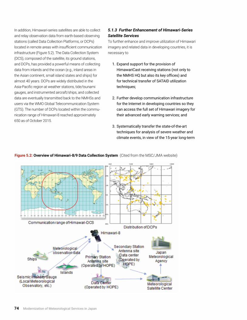
74 Modernization of Meteorological Services in Japan
In addition, Himawari-series satellites are able to collect and relay observation data from earth-based observing stations (called Data Collection Platforms, or DCPs) located in remote areas with insufficient communication infrastructure (Figure 5.2). The Data Collection System (DCS), composed of the satellite, its ground stations, and DCPs, has provided a powerful means of collecting data from inlands and the ocean (e.g., inland areas in the Asian continent, small island states and ships) for almost 40 years. DCPs are widely distributed in the Asia-Pacific region at weather stations, tide/tsunami gauges, and instrumented aircraft/ships, and collected data are eventually transmitted back to the NMHSs and users via the WMO Global Telecommunication System (GTS). The number of DCPs located within the commu-nication range of Himawari-8 reached approximately 650 as of October 2015.
5.1.3 Further Enhancement of Himawari-Series Satellite ServicesTo further enhance and improve utilization of Himawari imagery and related data in developing countries, it is necessary to
1 . Expand support for the provision of HimawariCast receiving stations (not only to the NMHS HQ but also its key offices) and for technical transfer of SATAID utilization techniques;
2 . Further develop communication infrastructure for the Internet in developing countries so they can access the full set of Himawari imagery for their advanced early warning services; and
3 . Systematically transfer the state-of-the-art techniques for analysis of severe weather and climate events, in view of the 15-year long-term
Figure 5.2: Overview of Himawari-8/9 Data Collection System (Cited from the MSC/JMA website)

Experiences in International Programs and Projects 75
operation of Himawari-8/9 and anticipated advancement of meteorological services .
The operation of Himawari-8 is widely welcomed by WMO and the world weather community as the start of a new era for geostationary meteorological satellites. Himawari-8 is expected to further contribute to the prevention and mitigation of weather-related disasters in the East Asia and Western Pacific regions.
5.2 Regional and World Centers in JMA under WMO Programmes
5.2.1 International Communication System Centre and Regional Specialized Meteorological Centres (RSMCs)
Functions of the International Communication System Centre and RSMCsIn addition to JMA’s domestic meteorological telecommunication services in Japan, JMA’s ADESS
information system (see Section 1.4 and Annex A3.1.1) exchanges observational data and weather-related products internationally under the GTS of the WMO’s World Weather Watch (WWW) programme (Figure 5.3). JMA has served as one of the Regional Telecommunication Hubs (RTHs) in Asia (Region II) since 1968—almost half a century. At the same time, JMA has operated RSMCs of the Global Data-processing and Forecasting System (GDPFS) to provide analyses and forecast products on both a real-time and non-real-time basis.
Contribution to the WMO Information System (WIS)Using the latest ICT,16 WMO has worked to develop the WIS concept and design since 2003, and in 2011 the WIS entered into its implementation phase (see Figure 5.4 on page 76). The WIS is the coordinated infrastructure owned and operated by NMHSs. Built upon existing communication networks, including GTS and satellite-based communication networks, the WIS is the core information and data management
Figure 5.3: Schematic Overview of the Global Telecommunication System (Cited from the JMA website)
16 The WIS networks are based on three types of data and product exchange services: (1) Routine collection and dissemination service for time-critical and operation-critical data and products implemented essentially through
dedicated telecommunication means providing a guaranteed quality of service; (2) Data discovery, access and retrieval service implemented essentially through the Internet; and (3) Timely delivery service for data and products implemented through a combination of dedicated telecommunication means and of public
data-communication networks, especially the Internet

76 Modernization of Meteorological Services in Japan
infrastructure utilized by the WMO community; it provides linkages among all WMO Members and supports WMO programmes associated with weather, climate, water, and related environmental issues.
The WIS consists of three types of centers: (1) Global Information System Centres (GISCs), responsible for data catalogue management and distribution of information intended for global exchange; (2) Data Collection or Production Centres (DCPCs), designated for various WMO programme activities, including RSMCs; and (3) National Centres (NCs), established in each WMO Member state. JMA fulfills various international roles (listed in Annex A5.1.1), many of which are designated as a GISC or DCPC within the framework of the WIS. The WIS centers of JMA initiated their operation on 1 August 2011.17
Users of GISC operated by JMA (GISC-Tokyo) have expanded to WMO regions beyond Region II (Asia), thanks to advances in ICT, especially the Internet (Figure 5.5). By January 2015, the number of users (NMHSs) had reached 21 in Region II, 15 in Region V (South-West Pacific), and 48 in total. It is highly likely that NMHSs in developing countries will benefit from effective utilization of the WIS with the support of GISCs and RSMCs operated by JMA and other NMHSs. NMHSs in Regions II and V could ideally exchange further meteorological data and products for monitoring and forecasting of severe weather through a regional meteorological data network led by JMA and other global centres as part of the WIS.
Two case studies—one in Section 5.2.2 on the RSMC Tokyo–Typhoon Center and one in Annex A5.2.1 on the Tokyo Climate Center–Regional Climate Centre (Tokyo)—are presented as representative examples of JMA’s international contribution.
Figure 5.4: Schematic Diagram of the WMO Information System (Cited from WMO website)
17 An overview of WIS and related JMA activities is available at the WIS portal site of GISC-Tokyo/JMA: http://www.wis-jma.go.jp/cms/.

Experiences in International Programs and Projects 77
Figure 5.5: Number of Users (NMHSs) of GISC-Tokyo operated by JMA18 (Based on the data provided by JMA)
5.2.2 Regional Specialized Meteorological Centre (RSMC) Tokyo–Typhoon Center
Key Activities of RSMC Tokyo–Typhoon Center19
Since 1988, JMA has assumed responsibility for the analysis and forecasting of tropical cyclones (TCs) in the northwestern Pacific and the South China Sea within the framework of WMO’s WWW programme. The RSMC Tokyo–Typhoon Center provides comprehensive support to NMHSs in the responsible area, especially to ESCAP/WMO Typhoon Committee members for their TC forecast/early warning services, listed below:
1 . Monitor, analyze, and forecast TCs and associated severe weather phenomena, such as storm surge and strong winds, as appropriate;
2 . Issue TC information as advisory/guidance for NMHSs;
3 . Name TCs in the responsible area when their maximum sustained wind speeds are 34 knots or more;
4 . Conduct post-TC analysis;
5 . Provide annual on-the-job training events to forecasters from Committee member states; and
6 . Annually publish RSMC Tokyo Activity Report and Technical Review .
Good Practices of RSMC Tokyo–Typhoon Center to Support Developing CountriesThe ESCAP/WMO Typhoon Committee Attachment Training, which has been held annually at the JMA
18 Six WMO Regional Associations are shown in Annex A5.1.19 The detailed activities of the RSMC Tokyo–Typhoon Center are presented on the JMA website:
http://www.jma.go.jp/jma/jma-eng/jma-center/rsmc-hp-pub-eg/RSMC_HP.htm.

78 Modernization of Meteorological Services in Japan
HQ since 2001, invites forecasters from Committee member states to improve their skills in analyzing and forecasting TCs (Photo 5.1). The training course is organized with a small group (two to three) of selected forecasters and JMA lecturers so as to facilitate an intensive two-week program for the sound and effective transfer of knowledge and skills.
At the request of the Typhoon Committee, the RSMC Tokyo–Typhoon Center initiated the WMO Storm Surge Watch Scheme in 2011 to issue storm surge information for Typhoon Committee members (Figure 5.6). The center provides distribution maps of predicted storm surges induced by TCs and time-series charts for requested sites from the members through a JMA
Photo 5.1: Typhoon Committee Attachment Training.(On-the-job training for typhoon analysis/forecast) (Provided by JMA)
Figure 5.6: Storm Surge Watch Scheme for Typhoon Committee Members Operated by the RSMC Tokyo–Typhoon Center (Based on the figures provided by JMA)

Experiences in International Programs and Projects 79
website (password-protected). When Typhoon Haiyan in the Philippines caused devastating storm surges in November 2013, the Storm Surge Watch Scheme functioned very well in terms of storm surge prediction due to the technical transfer of the JMA storm surge model to the Philippine Atmospheric, Geophysical and Astronomical Services Administration (PAGASA), which duly provided timely storm surge warnings. Further promotion of public awareness of the heavy impact of storm surge is indispensable for more effective people-centered early warning services. In this connection, one of JICA’s projects in the Philippines is described in Section 5.4 as a case study to enhance service delivery and the public awareness.
5.2.3 Key Lessons Learned from GISC and RSMC ActivitiesJMA activities as GISC and RSMC, including TCC, have substantially contributed to the comprehensive support for capacity development to developing countries through the following: (1) dissemination of advanced observation, analysis, and prediction products specific to the region; (2) transfer of application techniques, including software to utilize these products; and (3) provision of training courses for meteorologists. JMA’s steady efforts have greatly facilitated the improvement of meteorological services in developing countries.
On the other hand, the programs also encountered some difficulties in developing countries, as follows:
1 . Information and communication networks and computer resources are still insufficient to take full advantage of GISC and RSMC products and supports through the Internet as the basic social infrastructure; and
2 . NMHSs often wish to introduce very sophisticated models and systems for rapid modernization, which poses a big challenge in some countries in light of the availability of resources and systems for sustainable operation .
Development of the social infrastructure and human resources is a critical investment strategy for the modernization of weather and climate services.
5.3 Training Programs and JICA Training Courses in MeteorologyJMA has been providing a variety of expert services and training programs to developing countries for decades. In 2014, over 10 training programs were implemented for around 100 trainees, covering overall weather services as well as more specific themes (e.g., typhoon, climate, meteorological instruments, satellite meteorology, weather radar observations, and information systems). In order to ensure the effectiveness of training, the programs generally comprise scientific/technical lectures, practical drills in weather analysis and forecast, and study tours of JMA’s operational facilities.
Among others, a series of JICA training courses in meteorology, conducted by JMA every year and lasting three/four months, has received more than 310 meteorologists from NMHSs in 75 developing countries since 1973.
5.3.1 Lessons Learned from Training CoursesIn most developing countries, securing the necessary number of highly educated experts, especially with backgrounds in meteorology and/or relevant earth sciences, is a difficult challenge. It is therefore imperative to establish a solid systematic education and training mechanism within NMHSs for sustainable human resources development; this can be done by utilizing various opportunities for long- and short-term fellowships programs and training activities.
Short-term training could expand and deepen the knowledge of participants, but longer-term training is vital to enable the participants to take full advantage of accumulated training experiences and ensure that acquired expertise is reflected in the improvement and enhancement of their services. Furthermore, it is very important to cascade the acquired expertise and skills to other staff members after training so as to raise the scientific and technical levels of the NMHS staff as a whole.

80 Modernization of Meteorological Services in Japan
5.3.2 Good Practices in JICA Training CoursesThe JICA training course in meteorology delivers substantial scientific/technical knowledge and skills for the operation of weather and climate services through intensive lectures and practical drills, which are provided mainly by JMA meteorologists/researchers who are engaged in practical operation of advanced services and research and development. Figure 5.7 shows participants in JICA training courses in meteorology since 1973.
The course is designed for potential executive management officers who are expected to be in charge of decision making in their NMHSs in the near future. In fact, a number of participants have gone on to hold the office of the Permanent Representative with WMO, or director of NMHS, or another senior management position, and have significantly contributed to the modernization of meteorological services in their respective countries through international cooperation with WMO, JICA, and JMA. The course, which has run for more than 40 years, is therefore highly appreciated by participants and their supervisors as well as governments. This type
Figure 5.7: Participants in JICA Training Courses in Meteorology (1973–2015) Grouped by (a) WMO Region and (b) Country (Top 20 Countries)20 (Based on the data provided by JMA)
20 Six WMO Regional Associations are shown in Annex A5.1.2.
(a)
(b)

Experiences in International Programs and Projects 81
of training course is extremely valuable and should be further enhanced as a strategic investment for human resources development in developing countries.
JICA’s Third Country Training Program has also been successful. It is a follow-up project to grant aid and promotes Japan’s South-South Cooperation in the field of meteorology. Since the inauguration of the RSMC Nadi–Tropical Cyclone Centre in Fiji in 1998 with JICA support, a series of JICA training programs—Regional Meteorology Training for Pacific Island Countries—has been conducted in Fiji by JMA experts in observation, maintenance of instruments, and cyclone warning services. The program provided NMHS staff from Pacific island countries with an excellent opportunity to improve their practical knowledge and skills in operational meteorological services.
Within the framework of training courses implemented by JICA and JMA, including WMO regional centres, a systematic mechanism should be established to transfer the attained knowledge and expertise of trainees to all the staff of respective NMHSs; this step would move modernization of meteorological services toward a more advanced stage.
5.4 Experiences in JICA ProjectsJICA provides technical cooperation, loan aid, and grant aid in an integrated manner as Japan’s ODA, and plans projects with its emphasis on requests from countries for effective implementation through the enhancement of countries’ self-reliant efforts (MOFA, 2014). In the field of meteorological services, JICA, in close collaboration with JMA, holds detailed discussions, and works to share awareness and understanding, with NMHSs in developing countries. It plans and implements projects fitted to actual needs, available resources, and other practical considerations (i.e., user-oriented support/investment).
Among ODA projects, JMBSC, in collaboration with JMA, has implemented and continues to implement JICA’s international technical cooperation projects for Indonesia, Mozambique, the Philippines, and small island developing states in Oceania, among others. The three-year technical cooperation projects in
Mozambique and the Philippines aim at enhancing the capacity for weather observation, analysis, forecast, and warning services (see Photo 5.2 on page 82). The three-year project in Indonesia focuses on adaptation to climate change in agriculture and other sectors.
Lessons learned from the implementation phase and the current states of clients are summarized below, with a special focus on capacity development.
5.4.1 Key Lessons Learned
Surface Weather ObservationsSurface weather observations are fundamental both to the WMO global observing system networks and to national networks for DRR, and accordingly various donors (financial institutions and development organi-zations) have provided meteorological instruments and equipment to NMHSs in developing countries for the enhancement of observation systems. Even in the oper-ation of basic observation systems, NMHSs frequently encountered certain difficulties.
The difficulties on the recipient side primarily stem from insufficient financial support to the NMHS by government, particularly for the maintenance of observation systems and development of human resources. The lack of support, which is due to priority setting for national investment within the limited government budget, generally results in the following:
1 . Insufficient technical know-how among NMHS staff to allow them to manage and maintain the modern observation and information systems and to secure consistent operation of those systems on a 24/7 basis, although this also has to do with the systems’ complexity and with incomplete maintenance records, as well as lack of technical expertise in electronics and telecommunications;
2 . Insufficient traceability of meteorological instruments at national, regional, and global levels, due to inadequate deployment and operation of national standards traceable to international ones; and

82 Modernization of Meteorological Services in Japan
Photo 5.2: Training on (from top) Quality Assurance of Observations, Barometer Calibration and Development of Weather Forecast Guidance in the Philippines by JMBSC Experts.

Experiences in International Programs and Projects 83
3 . Inappropriate instrumentation under severe environmental conditions—e .g ., use in tropical areas of sophisticated instruments developed for observations at middle and high latitudes .
These difficulties eventually cause the disruption of observations and deterioration of data quality without traceability, and some observation systems may be left to malfunction for a long time after the disruption.
In this context, the problems induced by donors include the following:
1 . Disorganized and disharmonized observation systems that are part of independent projects of multiple donors without adequate coordination; and
2 . Incomplete project development and implementation without appropriate preparatory and follow-up actions for sustainable operation, in particular the following:a) Insufficient knowledge sharing with
recipient country on system design, development, and integration;
b) Insufficient spare parts and consumables; and
c) Insufficient education and training (lack of systematic human resources development) .
Introduction of Weather Radar SystemsToday, many donors are ready to provide support to developing countries for very sophisticated Doppler weather radars. But the above difficulties would also apply in this case, especially the problem of insufficient technical knowledge and skills for sound management, operation, and maintenance of the system. Another problem would be insufficient education and training to ensure that forecasters could best utilize radar data for early warning services. Coordinated and complete technical supports to developing countries are required for all processes, including observations, application of observed data by meteorologists to forecasts and
warnings, and the advanced QPE/QPF techniques for early warning services.
Transfer of Modern Forecasting/Prediction TechniquesIn order to successfully transfer the latest techniques and expertise in weather forecasting and climate prediction, and to promote self-reliant operation and improvement of services after the projects have ended, qualified staff members such as project managers and/or counterparts must be allocated stably at all stages, from planning to completion of the projects under the supervision of the executive management. In some cases, counterparts in charge of project implementation in recipient countries change even during the implementation of the project, which is likely to interfere with a smooth technological transfer.
5.4.2 Good Practices of JICA Projects Related to Meteorological Services In view of the lessons learned, the current JICA projects attach primary importance to securing the medium-/long-term sustainability of operational meteorological services by several means, from the planning phase onward, as follows:
1 . Projects are designed and developed to enhance country’s self-reliant efforts .
2 . Developing countries agree to provide the maintenance costs after the installation of meteorological instruments/equipment by JICA projects; this secures a sound funding mechanism for a long-term stable (i .e ., sustainable) operation .
3 . After the installation of systems by grant aid, successive follow-up technical cooperation projects are provided for effective and sustainable operation and services, especially those for human resources development .
For instance, as a follow-up program to the installation of three weather radar systems for the Philippines by grant aid in 2009–2013, a three-year technical cooperation project from 2014 to 2016 was developed

84 Modernization of Meteorological Services in Japan
and is under implementation to enhance the capacity for operational services of PAGASA. The project covers wide areas of technical assistance in:
1 . Human resources development in weather observation, data analysis, and forecasting;
2 . Elaboration of warning criteria to improve warnings for extreme events;
3 . Enhancement of public weather services through the improvement of websites; and
4 . Awareness-raising activities for the public and students .
Key lessons learned from the modernization processes of JMA services described in Chapter 3 have contributed to the planning and implementation of the above specific targets. Successful outcomes of JICA projects implemented by JMBSC have been achieved through the following:
1 . Proper survey by experienced experts to identify the real requirements of the recipient NMHS, and suitable medium- and long-term design of projects tailored to recipient’s needs, available resources, and other relevant circumstances;
2 . Full understanding of the project’s purpose, objectives, and expected outcomes on the part of the NMHS executive management, focal points, and staff, in order to ensure effective project design and implementation; and their continued involvement in all the implementation phases;
3 . Consistent improvement of the staff’s technical level through intensive and repeated training programs provided through relevant projects; and
4 . Close collaboration and cooperation by recipients and donors with JMA and its international centers, e .g ., the Regional Instrument Centre .
Developing countries can attain sustainable and enhanced meteorological services through continued collaborative efforts by donors and recipients, and through recipients’ long-term efforts toward self-reliance.

Guidance on Modernizing NMHSs 85
The lessons learned in the evolution of meteorological services in Japan (Chapters 2 to 4) and the experiences in international programs and projects (Chapter 5) can be the basis for comprehensive strategic guidance for developing countries and a useful instrument for World Bank task team leaders and other project managers in designing and implementing modernization projects under their development cooperation programs and projects. Some key recommendations are proposed below with reference to the outcomes/conclusions of this review.
6.1 Recommendations for Developing Countries
Recommendation 1: In order to effectively facilitate and accomplish successful modernization of meteorological services, long-term sustainable development efforts by NMHS staff themselves based on their well-defined medium- and long-term strategies are required, along with the sustained commitment and support of the world community.The modernization of JMA operational services has been realized through strategic investments to improve service delivery to end-users and meet evolving and diversifying societal needs, and through step-by-step improvements over 60 years. The medium- and long-term development strategies and plans should be clearly defined for the step-by-step improvement of service delivery through the total integration and networking of systems (for observation/monitoring, analysis, information processing, and forecast/warning). A mechanism for total planning and management should be established within NMHS in
cooperation with experts and stakeholders, including central and local governments. A steering mechanism is required to provide appropriate advice and guidance to the NMHS executive management on the basic strategies for modernizing meteorological services. According to the established long-term strategies, NMHS itself should set appropriate priorities and allocate available resources for development cooperation projects, particularly in the case where the projects are supported by multiple donors.
Recommendation 2: Policy, legal, and institutional frameworks should be established in order to clearly define the roles and responsibilities of the NMHS and other organizations within the central and local governments, and in order to enhance collaboration with stakeholders.In 1952, following World War II and some 70 years of services in the early development years, the legal framework of meteorological services in Japan was established by the formulation of the Meteorological Service Act, which specifically defined JMA’s roles and responsibilities, as well as the collaboration mechanism for JMA, other relevant government organizations, and the private meteorological sector, all in line with the national policy. The Meteorological Service Act serves as the basis for securing sustainable human, technical, and financial capacities for NMHS’s services. It is highly recommended that a solid legal framework (like the Meteorological Service Act) be established as a fundamental tool for comprehensive and sustainable meteorological services in developing countries.
6. Guidance on Modernizing NMHSs

86 Modernization of Meteorological Services in Japan
Recommendation 3: To facilitate effective early warning services, it is important to establish a legal framework that makes NMHS the single authoritative voice for warning services, along with the efficient communication and dissemination mechanisms for end-users.The Meteorological Service Act regulates the issuance of warnings by JMA—for severe weather, earthquake ground motions, tsunami, ocean waves, storm surges, and flood—as the national single authoritative voice for early warning services, and requires immediate notification to the authorities of disaster countermeasures and the public. Based on this fundamental framework in national DRR activities, JMA has developed and established very effective early warning services in practical collaboration with relevant authorities. This framework has enabled significant reduction of natural disaster damage through efforts to improve society’s coping and adaptive capacities to reduce vulnerability to natural hazards.
Recommendation 4: Human resources are a vital asset of NMHS, and long-term sustainable efforts in human resource development are indispensable for modernization.Human resources with advanced knowledge of science and technology and advanced skills in research and development are the most important asset for NMHSs in developing and operating observation and forecasting systems and services. JMA has made long-term efforts in sustainable human resources development in order to realize modernization.Education and training opportunities offered by the world community should be effectively utilized. After training, it is indispensable to cascade the acquired expertise and skills to other staff members so as to raise the scientific and technical knowledge of the NMHS staff as a whole. A systematic mechanism to transfer the attained knowledge and expertise to all the staff should be established to promote a more advanced stage of modernization.
Recommendation 5: Sound observation systems—those with a high degree of traceability of instruments within national, regional, and global meteorological communities and with adequate maintenance of on-site meteorological instruments for quality assurance and data archive—should be developed as the fundamentals of meteorological services.JICA’s international cooperation projects encountered some inadequate circumstances in several areas, including weather observations, maintenance of on-site meteorological instruments, and data archive and rescue (which are designed to develop reliable long-term observation databases—e.g., for surface, radar, and satellite data—for research and development to improve service delivery). These difficulties in developing countries could disrupt observations and cause deterioration of the data quality without traceability, and some of observation systems may be left to malfunction for a long time after disruption. International and regional frameworks, e.g., under the WMO Commission for Instruments and Methods of Observations (CIMO), should be suitably utilized for observation quality assurance and management. Within these frameworks, exchange of the observed data should be further promoted both within the country and with neighboring and regional NMHSs, in particular for radar data, through design of systems with a standard/common data format. Recruitment and appropriate training of technical experts in electronics and telecommunications should also be sought.
Recommendation 6: Sound operational meteorological systems and services are essential for early warning services on a 24/7 basis. Thus the establishment of a hot backup system should be taken into account in the long-term strategy for the modernization of systems and services.Sound operational meteorological systems are essential for early warning services by NMHSs on a 24/7 basis in the event of typhoon, severe weather, earthquake and tsunami, volcanic eruptions, and other natural disasters. Throughout its long-term system developments with step-by-step improvement over

Guidance on Modernizing NMHSs 87
decades, JMA has developed sound operational systems. The latest systems are highly redundant in order to ensure sound operational services in the event of disasters, power failure, or malfunctions of/accidents to systems and communication networks. JMA’s observation and monitoring systems are remotely controlled/monitored centrally at the JMA HQ, with geographically redundant systems at Osaka and/or Fukuoka regional HQs. The redundant center located at Osaka Regional HQ also ensures business continuity for monitoring, forecasts, and warnings for earthquakes and tsunami. Throughout the development and implementation of a long-term strategy for the modernization in developing countries, at least a geographically separated second center should be established that can operate basic emergency services.
Recommendation 7: Seamless early warning services with a comprehensive multi-hazard approach should be developed for effective early warning services.In Japan, monitoring, forecasting, and warning for almost all severe phenomena or natural hazards are carried out by one government authority, that is, JMA, in collaboration with the relevant authorities. JMA has developed risk-based warning services for multi-hazards in weather and climate services with sequential provision of information as severe events evolve. Moreover, JMA has established a comprehensive multi-hazard approach based on experiences with disastrous tropical cyclones, earthquakes, and volcanic activities. Adequate institutional settings, technical bases, and human resources are critical for drawing on these lessons learned historically in Japan to tackle multi-hazards. In developing countries, the institutional structures to monitor natural severe phenomena and related information services are different from country to country. Japanese experiences could not necessarily be simply applied to those countries. However further development or advancement of seamless early warning services with a comprehensive multi-hazard approach and collaboration with relevant authorities
is highly recommended to provide coordinated information to the government authorities and the public.
Recommendation 8: Establishment of systematic assessment mechanisms is crucial for an effective total (quality) management system/cycle of service delivery, from planning, operation, and validation to improvements designed to meet user requirements.In Japan, governmental national services are required to conduct systematic assessments on the quality of services delivered to the relevant authorities and the public. JMA has periodically assessed the accuracy of weather forecasts and typhoon forecasts over several decades and disclosed the findings to the public. Systematic verification of forecasts and warnings and their disclosure promotes a common understanding among stakeholders and the public, and also helps to improve services. Furthermore, in the process of management and planning with assessments of service delivery, experiences and lessons learned from devastating disasters offer suitable opportunities to improve service delivery and collaboration with relevant authorities and the public.
Recommendation 9: Well-organized coordination and collaboration mechanisms should be established with stakeholders, including central and local governments, the mass media, various user sectors, and the public.JMA has developed well-organized coordination and collaboration mechanisms with stakeholders. Examples include those for real-time exchange of observation data with central and local governments to improve service delivery and strengthen cooperation, and those with local governments and the mass media to raise public awareness about early warning services. Well-organized coordination and collaboration mechanisms should be developed and enhanced within the national (as well as regional and global) institutional frameworks, in particular for effective early warning services.

88 Modernization of Meteorological Services in Japan
Concluding NotesTo promote successful modernization of meteorological services based on the above recommendations, NMHSs should take into account the following points in project development:
1 . Give a higher priority to the effective utilization of currently available science and technology as well as financial and human resources; and
2 . Carry out step-by-step implementation of modernization projects in accordance with advances in science and technology as well as future development of human resources
It should be underlined that the above recommendations for developing countries are also valid for design and management of modernization projects by development partners.
6.2 Recommendations for Designing and Implementing Modernization Projects
Recommendation 10: Modernization projects should be designed with proper understanding and recognition of the international foundation of NMHSs, that is, meteorological services in a specific country should be based on harmonized global observation and data exchange networks.International cooperation at global and regional levels is essential for harmonized development of meteorological services built on global observation and information systems. The World Meteorological Organization provides a framework for such international cooperation under the Convention of WMO established in 1947, with 185 current Member states and six territories. WMO has long developed its harmonized observation and information networks for real-time services in collaboration with its Members. Thus based on such WMO networks, the benefits of internationally traceable observations, currently promoted under a JICA project, would be brought not only to the specific recipient country but also to other countries.
Recommendation 11: Modernization projects should be developed and implemented in accordance with harmonized, coordinated, and collaborative international programs of WMO and other international organizations, in collaboration with NMHSs.Development and implementation of modernization projects should be well harmonized and coordinated with the following WMO programmes or frameworks: (1) optimum development or enhancement of surface and upper-air observations within the country; (2) regional programmes to enhance capacity and capability of NMHSs in developing countries; and (3) activities of global and regional centres of WMO operated by responsible NMHSs (such as JMA) and their supports to developing countries.
JMA’s international activities are fully in line with the above WMO programmes and frameworks. Thus it is recommended that potential donors draw on JMA’s expertise and/or closely collaborate with JMA for effective project design and development. JICA, in close collaboration with JMA, holds detailed discussions and works to share awareness and understanding with NMHSs in developing countries, and develops and implements development cooperation projects fitted to countries’ actual needs and requirements. With such collaboration, the effective technical transfer to developing countries has been realized through the international activities of JMA, including its global and regional centers.
Recommendation 12: Proper fact-finding on the present situation of NMHSs in developing countries is indispensable for effective investments and outcomes so as to avoid mismatch.Efficient preliminary surveys for the assessment of countries’ actual needs, available resources, and other relevant circumstances are necessary for effective project design and development. Special attention should be paid to the stage of modernization and technical strengths/weaknesses in the recipient country.
Guidance on Modernizing NMHSs 89
In developing countries, inappropriate technical operation and maintenance of modern systems, as well as an insufficient number of technical experts (including experts in electronics and telecommunications), could cause deficient observations and inaccurate forecasts. These circumstances are mainly owing to insufficient analysis of the actual capacities of NMHSs for the development of sustainable projects, e.g., for long-term operation by a recipient NMHS even after completion of the specific project.
JICA develops projects with special emphasis on enhancing countries’ self-reliant efforts. Furthermore, the current JICA projects attach primary importance to securing the medium- or long-term sustainability of operational meteorological services by several means, from the planning phase onward.
The appropriate support forms and processes for developing countries fundamentally depend on several factors in the specific country, such as these:
1 . Responsibility of the government authorities, including NMHS, for disaster countermeasures;
2 . Government policy on the operation of NMHS, including administration and finance;
3 . User requirements and needs;
4 . Socio-economic and industrial activities; and
5 . Available science and technology, including ICT .
Recommendation 13: Long-term strategic investments are necessary for designing and implementing modernization projects through step-by-step and multi-phase subprojects, with appropriate evaluation and optimization in the implementation phase.Modernization of an NMHS is a long-term effort. The modernization of JMA operational services has been realized through the step-by-step introduction of state-of-the-art science and technology over 60 years. The modernization projects generally allow much shorter periods for implementation; thus it becomes more important to develop modernization projects with a series of step-by-step and multi-phase subprojects. Periodical evaluation and optimization in the implementation phase of the subprojects are critical so as to ensure the projects’ long-term sustainability.
The following recommendation (Recommendation 14) on sustainable human resources development is one of the most important points to consider in designing and implementing development cooperation programs and projects.
Recommendation 14: Modernization projects should focus attention on the sustainable development of human resources, not just the introduction of modern systems, as an integral part of modernization program.Human resources are a key asset for NMHSs in developing and operating observation and forecasting systems and services. JMA’s efforts to develop human resources in order to realize the modernization of its services extend over 90 years.
Despite increasing focus on capacity building in many international development cooperation projects, it can be difficult to develop the needed human resources and expertise, and to enhance the capacity of NMHS staff to handle and operate the advanced techniques/systems that go into maintaining long-term sustainable observations and services. A series of step-by-step and multi-phase subprojects should be considered for sustainable human resources development.

90 Modernization of Meteorological Services in Japan
In view of the lessons learned, the current JICA projects attach primary importance to training of experts by several means, ranging from a series of training courses to core components of multi-phase development cooperation projects for specific countries.
Recommendation 15: Establishment of well-organized collaboration and coordination mechanisms for donors and world meteorological communities (WMO and NMHSs), under the NMHSs’ leadership, is indispensable for effective modernization of NMHSs in developing countries.International development donor organizations have traditionally offered support independently of one another, based on their own fact-findings, interests, and priorities; this support has not necessarily been strongly collaborative or well-coordinated. Some bilateral collaboration mechanisms have recently been developed, such as the high-level agreement between JICA and the World Bank in July 2014. These mechanisms should be developed into further well-organized institutional collaboration and coordination mechanisms among donors (financial institutions and development cooperation agencies) and international organizations (e.g., WMO) to facilitate more harmonized and cost-effective supports for the related projects.
To achieve substantial progress in modernizing within a specific country, support from donors should go toward the development of services matched to actual needs, available resources, and other practical situations of the countries as experienced in JICA projects (Section 5.4). This should be aligned with the NMHS’s consolidated long-term strategic plan and management developed by NMHSs themselves (ref. Recommendation 1).
The following principles could be proposed so as to improve donor coordination and increase efficiency of support: (1) support/investment should not be donor-driven but rather user-oriented (i.e., based on the NMHS’s consolidated long-term strategic plan
and under the NMHSs’ leadership); (2) collaboration/coordination with international programs (e.g., WMO programmes) should be sought; (3) global sharing mechanisms could be established for real user requirements and environment, assessed/evaluated benefits and lessons learned from past projects, and planned supports by potential donors; (4) regular meetings among potential donors should be held for collaboration/coordination and information sharing, if possible; and (5) the right support by the right donor should be considered based on the scale and urgency of project/requirements. WMO (being fully aware of its Members’ requirements) could play a leading role in this donor collaboration/coordination. For example, the WMO Informal Planning Meeting on the Voluntary Cooperation Programme has facilitated information sharing on project implementation as well as planning and coordination of technical cooperation activities among WMO Members and collaborating development partners.
Recommendation 16: To enhance public-private partnerships (PPP) in developing countries, it is essential to build and secure robust national meteorological services by NMHSs in support of private meteorological services. When developing countries apply Japanese experiences in PPP, it is highly recommended that they establish institutional frameworks for (1) a single authoritative voice for warning services by NMHSs; (2) nationwide meteorological services based on advanced science and technology, handled by NMHS staff themselves; and (3) government policy on the operation of NMHS and the involvement of the private sector, particularly relating to administration and finance.
The government policy on commercial activities in meteorological services differs from country to country. The Japanese legal framework is a sophisticated example that clearly defines the roles and responsibilities of NMS and the private sector and ensures the broader use of meteorological data and information, thus bringing greater benefits to the public as well as socio-economic activities. On the other hand, some NMHSs in developed countries provide specific

Guidance on Modernizing NMHSs 91
meteorological services on a commercial basis besides general and specific services for which the government is responsible.
The future application of PPP activities in developing countries would depend on several factors, such as (1) level and speed of socio-economic development; (2) user requirements and needs; and (3) roles and responsibilities of the government(s) to meet growing and diversifying societal needs.
Concluding NotesDeveloped countries, donors, and international organizations should support and coordinate the following in order to enhance capacities and facilitate modernization in developing countries:
1. Developing countries themselves should develop and establish well-defined medium- and long-term strategic planning and management for sustainability, which should include the development, operation, and maintenance of observation, monitoring, and forecast systems and the improvement of service delivery to user communities (with reference to Recommendations 1–9);
2. International supports by several donors should be provided based on the NMHS’s consolidated long-term strategic plan and management, and well-organized institutional collaboration/coordination mechanisms should be established among donors and international organizations, under the NMHSs’ leadership;
3. Supporting targets in each developing country should be prioritized based on the current status of systems and services, including human resources, and on the status of societal foundations; and
4. Societal foundations/infrastructure, including power and ICT networks, should be improved .

92 Modernization of Meteorological Services in Japan
The following areas could be proposed as next steps for possible application of Japanese lessons in project development for the improvement and enhancement of early warning services and for mainstreaming of disaster risk management in developing countries:
1 . Formulate a draft guideline for more precisely assessing the current capacity of, and real requirements for, modernizing national meteorological services in developing countries, based on Japanese lessons and experiences summarized in this report (especially along with the preceding set of recommendations), through a couple of preliminary/preparatory survey missions and a follow-up series of fact-finding missions to finalize the document.
2 . Conduct assessment missions to selected developing countries, where modernization is urgently required and steady progress is expected, using the above guideline . Based on the precise assessment of actual needs, available science and technology, financial and human resources, and societal foundations/infrastructure in each target country, an appropriate modernization project should be designed and formulated in light of long-term sustainable development, in close collaboration with the NMHS of the target country and other stakeholders .
3 . Develop and implement specific education and training programs and projects to facilitate application of Japanese knowledge, technology, and expertise to the modernization processes of NMHSs in developing countries, so as to raise the scientific and technical level of meteorological services, in line with the existing programs of the WMO global and regional centers operated by JMA and with the training courses by JICA for the effective transfer of advanced scientific and technical knowledge and skills .
4 . Assist in establishing legal and institutional frameworks for effective early warning services, through every means available, including appropriate training programs particularly designed for the executive management (senior officials) of NMHSs so as to enhance their decision-making and resource-mobilization activities . The Meteorological Service Act of Japan enacted in 1952 is one of the most advanced legal frameworks in the world meteorological community, followed by some countries in recent decades . The Japanese knowledge, lessons and experiences in this area could be suitably applied to developing countries by harmonizing them with their own legal frameworks related to the government organizations, finance and services, and the government policy . NMHS senior officials are required to take into account the specific governmental, societal, economic, and environmental realities of the country, in order to establish effective legal and institutional frameworks for early warning services, based on the solid foundation of national meteorological services .
A Note on Proposed Next Steps

A Note on Proposed Next Steps 93
5 . Offer extensive financial and technical support for further enhancing and advancing the utilization of Himawari-8/9 imagery and related data, as a matter of urgency and for practical immediate improvement of early warning services in the Asia-Pacific region. For this purpose, the followings steps are proposed:
a) Expand support for the provision of HimawariCast receiving stations with technical transfer of utilization techniques to key NMHS centers in each country (including central and regional/local centers);
b) Further develop communication infrastructure for the Internet in developing countries to facilitate their advanced early warning services; and
c) Systematically transfer the state-of-the-art techniques on analyses of severe weather and climate events .
The support should be designed and implemented through accurate assessment of the situation of and requirements for planning; deployment of HimawariCast systems; trainings of forecasters; and follow-up programs for sustainable operational services.

94 Modernization of Meteorological Services in Japan
This review was conducted in the context of the Japan–World Bank Program for Mainstreaming Disaster Risk Management in Developing Countries. Japanese knowledge, technology, and expertise assessed through this review will significantly contribute to the modernization of NMHSs in developing countries, in particular in terms of systems, operations, and human resources development, as well as to World Bank operations. It is recommended that all the interested parties should draw on the experience of and/or closely collaborate with JMA in the process of modernizing operational weather, climate, ocean-related, and terrestrial services, especially in the Asia-Pacific region, through long-term sustainable efforts.
For sustainable development of effective early warning services by NMHSs in developing countries, it should be emphasized that better-performing observation, forecast, and warning services are acquired not only through modernizing operational systems with enhanced technical knowledge and skills; they also require strengthening user engagement and fostering a culture within NMHSs for quality assurance, data archiving, and compliance.
Closing Remarks

Acknowledgements to Contributing Stakeholders 95
A number of experts contributed to this review, and the Project Team of the Japan Meteorological Business Support Center (JMBSC) is grateful to them all. Special thanks are extended to the experts of the Japan Meteorological Agency (JMA), who were very helpful in providing a great deal of comprehensive and precise information on the past and current meteorological services in Japan, as well as valuable comments and suggestions for improvement of the report through fruitful discussions and careful reviews.
The following are contributing stakeholders who were directly interviewed or contacted, or who indirectly contributed to the review processes for preparing the report.
Japan Meteorological Agency:
• Dr. Toshihiko Hashida, Director-General of JMA (Former Director-General of the Forecast Department);
• Mr. Tatsuya Kimura, Director of the Aeronautical Meteorology Division (Former Head of the Office of International Affairs);
• Mr. Takuya Hosomi, Senior Coordinator for International Cooperation;
• Dozens of experts in the Administration Department, Forecast Department, Observation Department, Seismology and Volcanology Department, and Global Environment and Marine Department, especially those in the Global and Regional Centers of the World Meteorological Organization (WMO) and other international organizations operated by JMA; and
Acknowledgements to Contributing Stakeholders
• Former staff members of JMA who devoted a substantial effort to the modernization of Japanese meteorological services in various aspects, including the establishment, amendment, and reform of institutional frameworks; the development of observation, monitoring, information, and early warning systems; the improvement of service delivery; and the enhancement of international cooperation . Among them, Mr. Koichi Nagasaka, a former Director-General of JMA, thoroughly reviewed the draft reports and provided constructive comments and advice, especially on the international programs and projects.
National Meteorological and Hydrological Services (NMHSs) Supported under JICA Projects:
• The executive management (senior officials) and experts of NMHSs in recipient countries of JICA projects. Among others, those from Indonesia, Mozambique, the Philippines, and small island developing states in Oceania directly or indirectly offered important insights into specific reviews, particularly of international cooperation and recommendations toward future international cooperation projects.
Japan International Cooperation Agency (JICA):
• Mr. Kunio Akatsu, Disaster Reduction Group, Global Environment Department, JICA, who carefully reviewed the draft reports on the international programs and projects and contributed valuable comments and suggestions based on his extensive experiences in JICA international cooperation projects; and

96 Modernization of Meteorological Services in Japan
• Mr. Nobuo Sato and Mr. Kota Nakai, JICA experts, who have advanced technical expertise and experiences in JMA and have been working for JICA projects, implemented through JMBSC, for the Philippines and Mozambique respectively, and who provided valuable insights gained through the implementation of the JICA projects.
Japan Association of Meteorological Instrument Engineering (JAMIE):
• Mr. Daiichirou Komatsu, the former Chairperson of JAMIE and 10 representatives of its members from meteorological instrument/equipment manufacturers, who provided useful comments and advice based on their experiences in the development of instruments and international cooperation .
Conference for the Promotion of Public-Private-Partnerships
• The Conference for the Promotion of PPP, which is composed of 43 members (as of April 2016) of authorized forecast service companies, the mass media, and corporations related to information and communications . JMBSC serves as the Secretariat for the Conference . Valuable information on private meteorological services by members has been provided through various phases of the Conference activities .
Conference for the Utilization of Earthquake Early Warning (EEW)
• The Conference for the Utilization of EEW, which is organized by 113 members (as of April 2016) of authorized forecast service companies and corporations related to construction, railways, information, and communications . JMBSC also serves as the Secretariat for the Conference . Valuable
information on EEW-related private services by members has been provided through various phases of the Conference activities .
Other contributors
• The Disaster and Safety Information Center, News Department, Japan Broadcasting Corporation (NHK) . In particular, Mr. Nao Kobayashi provided useful documents and suggestions for the related media activities by NHK, particularly for the raising of public awareness about early warning services .
• The Team of Operation Services, All Nippon Airways (ANA) . In particular, Mr. Kei Sakamoto and ex-member Mr. Katsumi Yoshino provided useful information and materials for aviation services by ANA, specifically on its aircraft operation system and weather information .
Contents 97
Japan Meteorological Business Support Center (JMBSC)
MODERNIZATION OF
Meteorological Services in Japan
AND LESSONS FOR DEVELOPING COUNTRIES
Annexes

98 Modernization of Meteorological Services in Japan

Contents 99
Table of Contents
Annex (A) Reference Materials . . . . . . . . . . . . . . . . . . . . . . . . . . . . . . . . . . . . . . . . . . . . . .101
1 . Weather and Climate Services in Japan . . . . . . . . . . . . . . . . . . . . . . . . . . . . . . . . . . . .102A1 .1 Climate and Natural Disasters in Japan . . . . . . . . . . . . . . . . . . . . . . . . . . . . . . . . . . . . . . . . . . .102
1 .1 .1 Climate Change in Japan . . . . . . . . . . . . . . . . . . . . . . . . . . . . . . . . . . . . . . . . . . . . . . . .1021 .1 .2 Natural Disasters in Japan . . . . . . . . . . . . . . . . . . . . . . . . . . . . . . . . . . . . . . . . . . . . . .104
A1 .2 Overview of Organizational Structure and Services . . . . . . . . . . . . . . . . . . . . . . . . . . . . . . . . . .1061 .2 .1 Organizational Structures of Government and JMA . . . . . . . . . . . . . . . . . . . . . . . . .1061 .2 .2 Mission of JMA and Overview of Operational Weather Services . . . . . . . . . . . . . .107
A1.3 List of Real-time Information in General and User-specific Weather Services by JMA . . . .1091 .3 .1 Information for Severe Weather Preparedness . . . . . . . . . . . . . . . . . . . . . . . . . . . . .1091 .3 .2 Information for Daily Life including Health and Socio-economic Activities . . . . . .1101.3.3 Information for User-specific Services . . . . . . . . . . . . . . . . . . . . . . . . . . . . . . . . . . . .1111 .3 .4 Other Information . . . . . . . . . . . . . . . . . . . . . . . . . . . . . . . . . . . . . . . . . . . . . . . . . . . . . .111
2 . Institutional Evolution of Meteorological Services in Japan . . . . . . . . . . . . . . . . . . .112A2 .1 Chronology of the Japan Meteorological Agency (JMA) . . . . . . . . . . . . . . . . . . . . . . . . . . . . .112A2 .2 Meteorological Service Act . . . . . . . . . . . . . . . . . . . . . . . . . . . . . . . . . . . . . . . . . . . . . . . . . . . . . .114
2 .2 .1 Outline of Provisions in the Meteorological Service Act . . . . . . . . . . . . . . . . . . . . . .1142 .2 .2 List of Amendments to the Meteorological Service Act . . . . . . . . . . . . . . . . . . . . . .1162 .2 .3 List of Related Laws . . . . . . . . . . . . . . . . . . . . . . . . . . . . . . . . . . . . . . . . . . . . . . . . . . . .118
A2 .3 Policy-making and Coordination Mechanisms in Meteorological Services in Japan . . . . . .119
3 . Modernization of Observation and Forecasting Systems and Service Delivery in Japan . . . . . . . . . . . . . . . . . . . . . . . . . . . . . . . . . . . . . . . . . . . . . . . . .120
A3.1 Evolution of Specific Observation and Information Systems, and Associated Service Delivery . . . . . . . . . . . . . . . . . . . . . . . . . . . . . . . . . . . . . . . . . . . . . . . . . . . . .120
3 .1 .1 Computer System for Meteorological Services (COSMETS) and NWP Models . .1203 .1 .2 Automated Meteorological Data Acquisition System (AMeDAS) . . . . . . . . . . . . . .1223 .1 .3 Weather Radars . . . . . . . . . . . . . . . . . . . . . . . . . . . . . . . . . . . . . . . . . . . . . . . . . . . . . . . .1223.1.4 Upper-air Observation Systems . . . . . . . . . . . . . . . . . . . . . . . . . . . . . . . . . . . . . . . . . .1243 .1 .5 Aeronautical Meteorological Observations . . . . . . . . . . . . . . . . . . . . . . . . . . . . . . . . .124
A3 .2 Evolution of Weather Radar and Products . . . . . . . . . . . . . . . . . . . . . . . . . . . . . . . . . . . . . . . . . .1263 .2 .1 Graphical Presentation of the Evolution of Weather Radar and Products . . . . . . .1263 .2 .2 Historical Evolution of Weather Radar Observations and Service Delivery . . . . . .128
A3 .3 History of the Geostationary Meteorological Satellite Himawari Series . . . . . . . . . . . . . . . . .129A3 .4 Evolution of JMA Numerical Weather Prediction (NWP) Models . . . . . . . . . . . . . . . . . . . . . .130
3 .4 .1 Current Operational JMA NWP Models . . . . . . . . . . . . . . . . . . . . . . . . . . . . . . . . . . . .1303 .4 .2 Historical Evolution of JMA NWP Models . . . . . . . . . . . . . . . . . . . . . . . . . . . . . . . . . .1313 .4 .3 Data Coverage Maps for Global Analysis by NWP Models . . . . . . . . . . . . . . . . . . . .132

100 Modernization of Meteorological Services in Japan
A3 .5 Evolution of Typhoon Forecast in JMA . . . . . . . . . . . . . . . . . . . . . . . . . . . . . . . . . . . . . . . . . . . .1333 .5 .1 Historical Evolution of Typhoon Forecast in JMA . . . . . . . . . . . . . . . . . . . . . . . . . . .1333 .5 .2 Damage by Typhoon Vera (T5915) in 1959 . . . . . . . . . . . . . . . . . . . . . . . . . . . . . . . . .1353 .5 .3 Example of Seamless Early Warning Services/Standard Operating Procedures for Super Typhoons in Nagoya LMO . . . . . . . . . . . . . . . . . . . . . . . . . . . .137
A3 .6 Risk-Based Early Warning Services in JMA . . . . . . . . . . . . . . . . . . . . . . . . . . . . . . . . . . . . . . . . .1383 .6 .1 Historical Evolution of JMA Warning Services . . . . . . . . . . . . . . . . . . . . . . . . . . . . . .1383 .6 .2 Early Warnings at the Municipality Level . . . . . . . . . . . . . . . . . . . . . . . . . . . . . . . . . . .1393 .6 .3 Soil-water Index and Run-off Index . . . . . . . . . . . . . . . . . . . . . . . . . . . . . . . . . . . . . . . .139
A3 .7 Early Warning Services for Earthquake and Tsunami . . . . . . . . . . . . . . . . . . . . . . . . . . . . . . . .1413 .7 .1 Modernization of Observation/Monitoring Systems and Early Warning Services . . . . . . . . . . . . . . . . . . . . . . . . . . . . . . . . . . . . . . . . . . . . . . . . . .1413 .7 .2 Current Seismometer and Seismic Intensity Meter Network . . . . . . . . . . . . . . . . . .1433 .7 .3 Information on Earthquakes and Tsunamis . . . . . . . . . . . . . . . . . . . . . . . . . . . . . . . .144
A3 .8 Observation and Early Warning Services for Volcanic Activities . . . . . . . . . . . . . . . . . . . . . . .1473 .8 .1 Volcanic Observation and Warning system . . . . . . . . . . . . . . . . . . . . . . . . . . . . . . . .1473 .8 .2 Example of Volcanic Ash Fall Forecasts . . . . . . . . . . . . . . . . . . . . . . . . . . . . . . . . . . .150
A3 .9 Oceanographic and Marine Meteorological Observations and Related Services . . . . . . . . .1513 .9 .1 Oceanographic Observation and Monitoring for Climate Services . . . . . . . . . . . . .1513 .9 .2 Marine Meteorological Forecasts and Warnings . . . . . . . . . . . . . . . . . . . . . . . . . . . .152
A3 .10 Typical NHK TV Broadcasts during Severe Weather Events . . . . . . . . . . . . . . . . . . . . . . . . . .153
4 . Evolution of the Public-Private Partnership . . . . . . . . . . . . . . . . . . . . . . . . . . . . . . . . .155A4 .1 Weather Observations Performed by Persons Other Than JMA and Verification of Instruments . . . . . . . . . . . . . . . . . . . . . . . . . . . . . . . . . . . . . . . . . . . . . . . . . . .155
4 .1 .1 Chronology . . . . . . . . . . . . . . . . . . . . . . . . . . . . . . . . . . . . . . . . . . . . . . . . . . . . . . . . . . . .1554 .1 .2 Weather Observations Other Than by JMA . . . . . . . . . . . . . . . . . . . . . . . . . . . . . . . . .1554.1.3 Number of Instrument Verifications . . . . . . . . . . . . . . . . . . . . . . . . . . . . . . . . . . . . . . .155
5. Experiences in International Programs and Projects . . . . . . . . . . . . . . . . . . . . . . . . .157A5 .1 International Roles of JMA and Areas of Responsibility . . . . . . . . . . . . . . . . . . . . . . . . . . . . . .157
5 .1 .1 World and Regional Centers . . . . . . . . . . . . . . . . . . . . . . . . . . . . . . . . . . . . . . . . . . . . .1575 .1 .2 WMO Regional Associations . . . . . . . . . . . . . . . . . . . . . . . . . . . . . . . . . . . . . . . . . . . . .158
A5.2 Case Studies for Experiences in International Programs and Projects . . . . . . . . . . . . . . . . . .1595 .2 .1 Tokyo Climate Center (TCC)–Regional Climate Centre (Tokyo) . . . . . . . . . . . . . . .1595 .2 .2 WMO Regional Instrument Centre (RIC) Tsukuba for Regional Association II (Asia) . . . . . . . . . . . . . . . . . . . . . . . . . . . . . . . . . . . . . . . . . . . . . . . . . . . .161
Annex (B) Other . . . . . . . . . . . . . . . . . . . . . . . . . . . . . . . . . . . . . . . . . . . . . . . . . . . . . . . . . . .163B1 Abbreviations . . . . . . . . . . . . . . . . . . . . . . . . . . . . . . . . . . . . . . . . . . . . . . . . . . . . . . . . . . . . . . . . . . . .164
B2 References . . . . . . . . . . . . . . . . . . . . . . . . . . . . . . . . . . . . . . . . . . . . . . . . . . . . . . . . . . . . . . . . . . . . . .167

Contents 101
Annex (A) Reference Materials
Annex A 101

102 Modernization of Meteorological Services in Japan
1. Weather and Climate Services in Japan
A1.1 Climate and Natural Disasters in Japan
A1.1.1 Climate Change in JapanCited from JMA (2015e): Climate Change Monitoring
Report 2014, JMA website (http://www.jma.go.jp/jma/en/NMHS/indexe_ccmr.html)
Rain
Figure A1.1.1: Annual Change of Rain from 1901 to 2014
Annual number of extremely wet/dry monthsThe graphs show the annual number of occurrences of the first-to-forth heaviest/lightest precipitation values for each month during the period from 1901 to 2014. The green bars indicate annual occurrences of extremely heavy/light monthly precipitation divided
by the total number of monthly observation data sets available for the year (i.e., the average occurrence per station). The blue line indicates the five-year running mean, and the straight red line indicates the long-term linear trend.
Annual number of days with precipitation > 100 mm and ≥ 200 mm The blue line indicates the five-year running mean, and the straight red line indicates the long-term linear trend.

Weather and Climate Services in Japan 103
Typhoon
Figure A1.1.3: Annual Change of Tropical Cyclone (Typhoon) from 1951 to 2014
Temperature
Figure A1.1.2: Annual Change of Temperature from 1901 to 2014
Annual number of days with minimum temperatures of <0°C and ≥ 25°C The graphs show the annual number of days per station, with the green bars
indicating the values for each year. The blue line indicates the five-year running mean, and the straight red line indicates the long-term linear trend.
Annual number of days with precipitation of ≥ 1.0 mm The blue line indicates the five-year running mean, and the straight red line indicates the long-term linear trend.
Numbers of tropical cyclones with maximum winds of 17.2 m/s or higher forming in the western North Pacific The thin and thick lines represent annual and five-year running means, respectively.
Numbers (blue) and rates (red) of tropical cyclone formations with maximum winds of 33 m/s or higher The thin and thick lines represent annual and five-year running means, respectively.

104 Modernization of Meteorological Services in Japan
Aeolian dust
“Kosa” (Aeolian dust)—a kind of aerosol—is fine particulate matter blown up from semi-arid areas of the Asian continent and transported by westerly winds
to Japan. Since Kosa has impacts for households, health, and aviation, JMA issues the related bulletins and information.
Figure A1.1.4: Annual Change of Aeolian Dust from 1967 to 2014
A1.1.2 Natural Disasters in Japan
Figure A1.1.5: Comparison of Natural Disasters in Japan and the World(Cited from Cabinet Office (2015) with English translation)
Number of days when any station in Japan observed Kosa (1967–2014) based on the 60 stations that were active for the whole period
Annual total number of stations observing Kosa in Japan (1967–2014) based on the 60 stations that were active for the whole period

Weather and Climate Services in Japan 105
Figure A1.1.6: Annual Change of Casualties (Dead/Missing) by Natural Disasters in Japan from 1945 to 2013 (Cited from Cabinet Office (2015) with English translation)
Figure A1.1.7: Annual Amount of Damage on Agriculture, Forestry and Fishery by Natural Disasters in Japan (1985–2014)
(Based on the statistical data by the Ministry of Agriculture, Forestry and Fisheries (MAFF): http://www.maff.go.jp/j/tokei/kouhyou/sakumotu/higai/ (in Japanese))
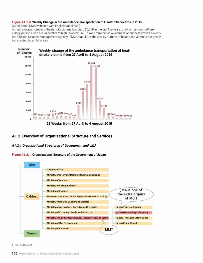
106 Modernization of Meteorological Services in Japan
Figure A1.1.8: Weekly Change in the Ambulance Transportation of Heatstroke Victims in 2015 (Cited from FDMA websites with English translation)Annual average number of heatstroke victims is around 50,000 in the last five years, of whom almost half are elderly persons who are vulnerable to high temperature. To maximize public awareness about heatstroke’s severity, the Fire and Disaster Management Agency (FDMA) tabulates the weekly number of heatstroke victims emergently transported by ambulances.
A1.2 Overview of Organizational Structure and Services1
A1.2.1 Organizational Structures of Government and JMA
Figure A1.2.1: Organizational Structure of the Government of Japan
1 Provided by JMA.

Weather and Climate Services in Japan 107
A1.2.2 Mission of JMA and Overview of Operational Weather Services
Figure A1.2.2: Organizational Structure of JMA
Figure A1.2.3: Mission of JMA
JMA provides meteorological information for . . .

108 Modernization of Meteorological Services in Japan
Figure A1.2.4: Overview of Operational Weather Services

Weather and Climate Services in Japan 109
A1.3 List of Real-time Information in General and User-specific Weather Services by JMA
A1.3.1 Information for Severe Weather Preparedness
Figure A1.3.1: Schematic Flow of Information for Severe Weather Events
Emergency Warnings
StormSnowstormHeavy rain
Heavy snowStorm surgeHigh waves
Warnings
StormSnowstormHeavy rain
Heavy snowStorm surgeHigh waves
Flood
Gale and snow Gale
Heavy rainHeavy snow Dense fog
ThunderstormDry air
Avalanche
Ice (snow) accretion
FrostLow temperature
Snow melting Storm surgeHigh waves
Flood
Emergency Warnings/Warnings/Advisories Emergency warnings/warnings/advisories are issued by the responsible local meteorological office (LMO) for each municipality.
Advisories

110 Modernization of Meteorological Services in Japan
Tropical Cyclone Information (Typhoon Forecast)The JMA HQ issues the tropical cycle forecasts listed below:
• Five-day track forecast;• Three-day track and intensity forecast;• 50-kt wind probability (map);• 50-kt wind probability (by prefecture); and• Bulletins for typhoon .
Bulletins and Alert InformationBulletins are issued successively to supplement the seamless early warning system, before and after warnings/advisories are issued. The JMA HQ, Regional HQs, and LMOs issue bulletins for respective responsible geographical areas at the national, regional, and prefectural levels, respectively. Typical bulletins for severe weather are for:
• Heavy rain, heavy snow, storm, snowstorm, high waves, storm surge by typhoon and developing/developed low;
• Thunderstorm and hails in summer season;• Storm and heavy snow by strong winter
monsoon; and• High tides by atmospheric and oceanic
disturbances .
Furthermore, LMOs issue bulletins and alert information to enhance the alert level for heavy rain, landslides,2 and hazardous winds based on observation and analysis, such as these:
• Bulletins on Exceptionally Heavy Downpours (observed/analyzed precipitation amounts within one hour);
• Landslide Alert Information for municipalities in collaboration with prefectural governments; and
• Hazardous Wind Watch (alert information on high probability of hazardous winds such as tornadoes and downburst within one hour) .
Analysis and Short-range Forecast of Severe WeatherThe JMA HQ provides nationwide gridded fine distributions of severe weather analysis and forecast as follows:
• Radar/Rain gauge-Analyzed Precipitation (R/A) and Very-short-range Forecasting of Precipitation (VSFP), hourly precipitation with 1-km resolution issued every 30 minutes for six hours ahead;
• Nowcasts for precipitation intensity with 1-km resolution issued every five minutes up to one hour ahead;
• Nowcasts for thunderstorms and hazardous winds such as tornadoes issued every 10 minutes up to one hour ahead with 1-km and 10-km resolution, respectively;
• High-resolution Precipitation Nowcasts (HRPNs) with 250-m resolution issued every five minutes up to 30 minutes ahead; and
• Real-time Landslide Risk Map based on soil-water index with 5-km resolution issued every 10 minutes .
A1.3.2 Information for Daily Life including Health and Socio-economic ActivitiesThe JMA HQ, Regional HQs, and LMOs issue weather/climate forecasts, bulletins, and alert information as in the following:
Forecast• Daily weather forecast up to two days ahead
issued by LMOs;• Area distribution forecast with 20-km resolution
up to 24 hours ahead at 0500 JST and 30 hours ahead at 1700 JST;
• Time sequence forecast for 142 forecast blocks across the country up to 24 hours ahead at 0500 JST and 30 hours ahead at 1700 JST;
• One-week forecast; and• Seasonal forecast up to one month, three
months, and six months ahead .
2 The term “landslides” refers to debris flows and concentrated slope failures hereafter.

Weather and Climate Services in Japan 111
Bulletin and alert information• Alert information on high temperature over
35°C for today/tomorrow;• Bulletins on climatic severe weather including
prolonged high and low temperature, rain and snow, and lack of sunshine duration; and
• Early warning information on climatic extreme weather up to two weeks ahead .
Alert information on atmospheric environment• Alert information on weather conditions which
induce risks of photochemical smog;• Information on ultraviolet radiation (UV Index
distribution of analysis and prediction for tomorrow); and
• Information on Aeolian dust (concentration distribution of analysis and prediction up to three days ahead) and bulletin for Aeolian dust .
A1.3.3 Information for User-specific Services• Flood warnings for specific rivers with the
National Hydrological Service (Water and Disaster Management Bureau) of MLIT and those of prefectural governments (see Section 3 .2 .4);
• Maritime meteorological services (see Annex A3 .9);
• Aviation weather services (see Section 3 .3); and• Bulletins for fire prevention (for fire services by
local governments) .
A1.3.4 Other InformationThe following basic information is provided by the JMA website and others on a real-time basis:
Weather• Weather charts of analysis and forecast;• Data and analyses of surface observations
at AMeDAS sites and LMOs, upper-air observations by wind profilers, and observations of ocean waves and tides; and
• Satellite imagery by Himawari-8, etc .
Climate, global environment, and ocean• Monitoring information on extreme climate
events including the prediction of El Niño phenomenon;
• Observation and analysis of global environment (e .g ., climate change and variability, carbon dioxide both in the atmosphere and ocean, and marine pollution); and
• Analyses and forecasts of sea surface temperature and oceanic currents in the northwestern Pacific and global oceans, and of sea ice in the coastal area of Hokkaido and the Sea of Okhotsk, etc .

112 Modernization of Meteorological Services in Japan
2. Institutional Evolution of Meteorological Services in Japan
A2.1 Chronology of the Japan Meteorological Agency (JMA)3
Table A2.1.1: Chronology of JMA
Year Event
1875 Tokyo Meteorological Observatory (TMO), predecessor of JMA, established within the Ministry of Interior.
1883 The first storm warning issued. The first weather map issued.
1884 The first national weather forecast issued.
1884 Nationwide seismic intensity observations started.
1887 TMO renamed the Central Meteorological Observatory (CMO).
1895 CMO transferred to the Ministry of Education.
1921 Oceanographic and marine meteorological observations started.
1922 Meteorological Expert Education School, predecessor of the Meteorological College, established.
1925 Weather forecast service by radio broadcast started.
1928 Marine meteorological service by radio broadcast started.
1930 Aviation weather service started.
1935 Storm warning divided into storm warning and storm advisory.
1938 Radiosonde upper-air observations started.
1941 Tsunami warning organization for the Sanriku coast established.
1942 Seasonal forecast service started.
1943 CMO transferred to the Ministry of Transport and Telecommunications.
1945 CMO placed under the Ministry of Transport (MOT).
1950 Current framework of weather warnings and weather advisories established.
1952 Meteorological Service Act brought into force.
3 Cited from JMA website with some revision.

Institutional Evolution of Meteorological Services in Japan 113
(* MLIT was reorganized into the Ministry of Land, Infrastructure, Transport and Tourism in January 2008.)
1953 Japan joined the World Meteorological Organization (WMO).
1954 Weather radar observations started.
1956 CMO became JMA, an affiliate agency of the Ministry of Transport.
1957 Observation in Antarctica started.
1959 Numerical Weather Predictions started.
1965 Provision of volcanic information started.
1969 Automated Data Editing and Switching System (ADESS) established.
1974 Automated Meteorological Data Acquisition System (AMeDAS) established.
1977 GMS (Himawari-1), JMA's first geostationary meteorological satellite, launched.
1980 Forecast for probability of precipitation started.
1984 Seismology and Volcanology Department established.
1988 Very-short-range Forecasting of Precipitation (VSFP) started.
1991 Seismic intensity meters observations started.
1993 Meteorological Service Act amended to establish Certified Weather Forecaster System.
1996 Area distribution forecast and time sequence forecast started.
2001 JMA placed under the Ministry of Land, Infrastructure and Transport (MLIT).*
2004 Provision of precipitation Nowcasts started.
2005 Global Environment and Marine Department established.
2008 Issuance of tornado alerts (Hazardous Wind Watch) started.
2009 Issuance of five-day track forecasts of typhoon started.
2010 Issuance of weather warning targeting municipalities started. Issuance of Nowcasts for thunderstorms and tornadoes started.
2013 Meteorological Service Act amended to introduce emergency warning.
2015 Operation of geostationary meteorological satellite Himawari-8 started.

114 Modernization of Meteorological Services in Japan
A2.2 Meteorological Service Act
A2.2.1 Outline of Provisions in the Meteorological Service Act
Table A2.2.1: Fundamental Elements of Meteorological Services Described in the Meteorological Service Act with a Brief Explanation of Key Articles and References to Chapters in the Main Report
Article Number Provision Brief Explanation
Article 1 Objectives of meteorological services to contribute to the promotion of public welfare through disaster prevention, securing traffic safety, promoting the prosperity of industries, and offering international cooperation
Clarification of the purpose of the Act (Chapters 2 to 5)
Article 2 Definition of terms, such as “meteorological services” and their covering areas, “observations,” “forecasts,” and “warnings”
Legal definition of terms given in the Act
Article 3 Roles and responsibilities of JMA, including establishing and maintaining comprehensive systems and networks for observation, forecast, and warning, and information exchange
Clarification of comprehensive roles and responsibilities of JMA as the National Meteorological Service so as to give fundamentals to other articles (Chapters 2 to 4)
Articles 4 to 9 Observations by JMA and by persons other than JMA including ships and aircraft and meteorological instruments used in observations with calibration (verification and certification)
Establishment of national observation networks by JMA with the harmonization (traceable quality) of observations by ships, aircraft, and other authorities; and their reporting mechanisms to JMA (Chapters 2 to 4)
Article 11 Dissemination of the results of observations and information on the meteorological, hydrological, and terrestrial phenomena to the public in cooperation with the media
JMA responsibility for issuing observation results and related information and for establishing effective dissemination mechanisms to the public with the media, which enhance effectiveness of services including forecasts and warnings (e.g., specific weather bulletins and information for alerts, seismic intensity information, etc.) (Chapters 2 to 4)
Article 13 Forecasts and warnings (expanded to introduce emergency warnings in 2013) by JMA for general use and their dissemination to the public in cooperation with the media
JMA responsibility for providing forecast and warning services and for establishing effective dissemination mechanisms to the public with the media (Chapters 2 to 4)

Institutional Evolution of Meteorological Services in Japan 115
Articles 14 and 16 Forecasts and warnings by JMA for shipping, aviation, railroad, electricity, and specific industries, and dissemination to the public
JMA responsibility for providing specific forecasts and warnings for the safety of ships, including fishing boats, and aircraft (Chapters 2 and 3)
Article 14-2 and 14-3 Flood forecasts and warnings for specific rivers in collaboration with MLIT’s National Hydrological Service (expanded to Hydrological Services of prefectural governments in 2005), and dissemination to the public
Provision of flood forecasting/warning services for specific rivers in collaboration with MLIT’s National Hydrological Service (and Hydrological Services of prefectural governments) to enhance flood management and disaster prevention activities (Chapters 2 and 3)
Article 15 Notification of warnings from JMA to the relevant authorities and their responsibility for dissemination of warnings to municipalities, public agencies, and the public (expanded in 2013)
Establishment of sound multiple routes to end-users for realization of the highly reliable warning dissemination mechanism (Chapters 2 and 3)
Articles 17 to 20 License and the standards (technical, staffing, etc.) for forecasting services by persons other than JMA (authorized forecast services by the private sector, and expanded to introduce the certified weather forecaster system and a private meteorological service support center in 1993) and responsibility of authorized forecast service companies to disseminate JMA warnings to users of their services
Establishment of harmonized forecast services in Japan in collaboration with the private sector (Chapter 4)
Article 23 Single authoritative voice for warnings by JMA (Restriction on warnings by persons other than JMA).
Establishment of the single authoritative source by JMA for early warning services to facilitate effective disaster countermeasures without confusion (Chapters 2 to 4)
Articles 28 to 34 Verification of meteorological instruments
Quality assurance of observations made by persons other than JMA, for realization of the harmonized and effective observation networks in Japan (Chapters 2 to 4)
Article 43-2 Council of Meteorological Services (Council of Transport Policy, at present)
Establishment of management and planning cycles (Chapters 2 and 3)

116 Modernization of Meteorological Services in Japan
A2.2.2 List of Amendments to the Meteorological Service Act
Table A2.2.2: Chronology of Institutional Frameworks of Meteorological Services in Japan
Year Event
1875
1887
1895
Tokyo Meteorological Observatory (TMO), predecessor of JMA, established within the
Ministry of Interior.
TMO renamed the Central Meteorological Observatory (CMO).
CMO transferred to the Ministry of Education.
1939
1943
Governmental Regulations for Meteorological Organizations.
CMO transferred to the Ministry of Transport and Telecommunications (1945: CMO placed
under the Ministry of Transport).
1948
1949
1952
1953
1956
1959
1961
1962
1968
1970
1973
1978
1980
1988
Fire Service Act brought into force (weather bulletins for fire prevention).
Flood Control Act brought into force (weather bulletins for flood management).
Act for Establishment of the Ministry of Transport.
Meteorological Service Act (hereafter called “Act”) brought into force.
Civil Aeronautics Act brought into force.
Became a Member of the World Meteorological Organization.
Became a Member of the International Civil Aviation Organization.
CMO became JMA, an affiliate agency of the Ministry of Transport.
Amendment to Flood Control Act (flood forecast for specific rivers in collaboration with JMA)
Amendment to Meteorological Service Act (flood forecast for specific rivers in
collaboration with the Ministry of Construction, and establishment of the Council of
Meteorological Services).
Typhoon Vera (T5915).
Disaster Countermeasures Basic Act brought into force.
Act on Special Measures for Heavy Snowfall Areas brought into force.
Air Pollution Control Act brought into force (weather bulletins for photochemical smog).
Transport Safety Basic Act brought into force.
Act on Prevention of Marine Pollution and Maritime Disaster brought into force.
Act on Special Measures for Active Volcanoes brought into force.
Act on Special Measures for Large-scale Earthquakes brought into force.
Amendment to Act (intensify monitoring in the Tokai region and report concerning
prediction).
Signatory to the International Convention for the Safety of Life at Sea (1974).
Act on the Protection of the Ozone Layer Through the Control of Specified Substances and
Other Measures (observations of the ozone layer, etc.).

Institutional Evolution of Meteorological Services in Japan 117
1993
1995
1998
2000
2001
2002
2007
2011
2012–13
2013
Amendment to Act (private meteorological service support center and certified weather
forecaster system).
Environment Basic Act brought into force.
The 1995 Great Hanshin-Awaji Earthquake.
Act on Special Measures for Earthquake Disaster Countermeasures (centralization of
earthquake data, etc.).
Amendment to Disaster Countermeasures Basic Act.
Act on Promotion of Global Warming Countermeasures brought into force.
Act on Promotion of Sediment Disaster Countermeasures for Sediment Disaster Prone
Areas brought into force.
JMA placed under the Ministry of Land, Infrastructure, Transport and Tourism (Act for
Establishment of the MLIT, 1999).
Amendment to Flood Control Act and Meteorological Service Act (flood forecast for
specific rivers in collaboration with prefectural governments).
Amendment to Act (verification of meteorological instruments).
Act on Special Measures for Promotion of Tonankai and Nankai Earthquake Disaster
Management brought into force.
Amendment to Act (warnings for strong ground motions by earthquakes and volcanic
activities).
The 2011 Great East Japan Earthquake.
Act on Promotion of Tsunami Disaster Countermeasures brought into force.
Amendment to Disaster Countermeasures Basic Act.
Amendment to Act (emergency warnings).

118 Modernization of Meteorological Services in Japan
A2.2.3 List of Related Laws
Table A2.2.3: Major Laws and Conventions Related to Meteorological Services in Japan
General disaster countermeasures• 1961: Disaster Countermeasures Basic Act
Severe weather and climate• 1948: Fire Service Act• 1949: Flood Control Act• 1962: Act on Special Measures for Heavy Snowfall Areas• 2000: Act on Promotion of Sediment Disaster Countermeasures for Sediment Disaster Prone Areas
Earthquakes, tsunami, and volcanic eruptions• 1973: Act on Special Measures for Active Volcanoes• 1978: Act on Special Measures for Large-scale Earthquakes• 1995: Act on Special Measures for Earthquake Disaster Countermeasures• 2002: Act on Special Measures for Promotion of Tonankai and Nankai Earthquake Disaster
Management • 2011: Act on Promotion of Tsunami Disaster Countermeasures
Safety of transport• 1933: Ship Safety Act• 1952: Civil Aeronautics Act• 1970: Transport Safety Basic Act
Global environment and pollution• 1968: Air Pollution Control Act• 1970: Act on Prevention of Marine Pollution and Maritime Disaster• 1988: Act on the Protection of the Ozone Layer Through the Control of Specified Substances and Other
Measures• 1993: Environment Basic Act• 1998: Act on Promotion of Global Warming Countermeasures
Organization of MLIT• 1999: Act for Establishment of the Ministry of Land, Infrastructure and Transport (MLIT became the
Ministry of Land, Infrastructure, Transport and Tourism in January 2008)
Conventions and signatory year• 1953: Convention of the World Meteorological Organization (1947)• 1953: Convention on International Civil Aviation (1944)• 1980: International Convention for the Safety of Life at Sea (1974)

Institutional Evolution of Meteorological Services in Japan 119
A2.3 Policy-making and Coordination Mechanisms in Meteorological Services in Japan
Table A2.3.1: Policy-making and Coordination Mechanisms in Meteorological Services in Japan Based on information provided by JMA

120 Modernization of Meteorological Services in Japan
3. Modernization of Observation and Forecasting Systems and Service Delivery in Japan
A3.1 Evolution of Specific Observation and Information Systems, and Associated Service Delivery4
JMA has developed, operated and upgraded/replaced many systems, such as (a) surface-based and space-based observation systems, including weather radars and satellites; (b) telecommunication and super-computer systems; (c) earthquake and tsunami monitoring systems; (d) monitoring system for volcanic activities; and (e) ocean and climate monitoring systems.
Among others, the Japanese geostationary meteorological satellite Himawari, which covers East Asia and the Western Pacific, is an essential means for early warning services for tropical cyclones and severe weather events for NMHSs in the region as well as JMA (see Annex A3.3). The operation of the Himawari series as well as plans for its future are described in Section 5.1 with the associated international cooperation activities.
Many current operational observation and information systems have reached the most advanced stage ever (4th modernization stage, see Section 1.2) through the medium-/long-term planning for replacement/upgrading, as described below.
A3.1.1 Computer System for Meteorological Services (COSMETS) and NWP ModelsHigh-performance telecommunication and data processing systems are essential for successful early warning services. JMA operates two major computer systems: one, the Automated Data Editing and Switching System (ADESS), is the center of the communication network for all data and products, including international data exchange; and the other,
the Numerical Analysis and Prediction System (NAPS), is the super-computer system for NWP models (see Figure A3.1.2).
The first ADESS was established in 1969 at the JMA HQ based on the latest computer technology, and it was extended into the network covering all of Japan, comprising the central (Tokyo) and local (regional HQs) systems during 1981–1987. The ADESS has been centralized within Tokyo with the redundant system in Osaka in 2005–2008. The ADESS and the NAPS are collectively called the Computer System for Meteorological Services (COSMETS).
Figure A3.1.1: History of Computers for NWP at JMA and Their Peak Performance
The line “Moore’s law” represents the projection of peak performance using Moore’s law from the first computer (IBM 704). The term “Moore’s law” has many formulations. Referred to here is the exponential growth of peak performance, which doubles every 18 months. Cited from JMA (2013)
4 Figures are provided by JMA.

Modernization of Observation and Forecasting Systems and Service Delivery in Japan 121
Figure A3.1.2: Computer System for Meteorological Services (COSMETS) and Related Systems
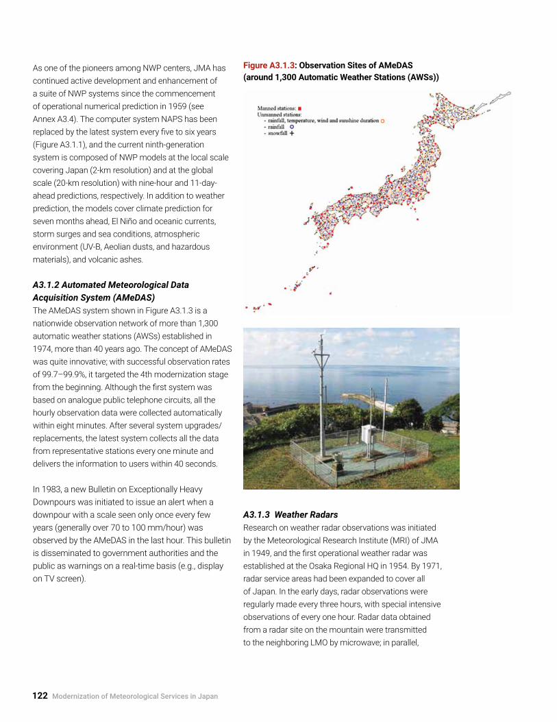
122 Modernization of Meteorological Services in Japan
As one of the pioneers among NWP centers, JMA has continued active development and enhancement of a suite of NWP systems since the commencement of operational numerical prediction in 1959 (see Annex A3.4). The computer system NAPS has been replaced by the latest system every five to six years (Figure A3.1.1), and the current ninth-generation system is composed of NWP models at the local scale covering Japan (2-km resolution) and at the global scale (20-km resolution) with nine-hour and 11-day-ahead predictions, respectively. In addition to weather prediction, the models cover climate prediction for seven months ahead, El Niño and oceanic currents, storm surges and sea conditions, atmospheric environment (UV-B, Aeolian dusts, and hazardous materials), and volcanic ashes.
A3.1.2 Automated Meteorological Data Acquisition System (AMeDAS)The AMeDAS system shown in Figure A3.1.3 is a nationwide observation network of more than 1,300 automatic weather stations (AWSs) established in 1974, more than 40 years ago. The concept of AMeDAS was quite innovative; with successful observation rates of 99.7–99.9%, it targeted the 4th modernization stage from the beginning. Although the first system was based on analogue public telephone circuits, all the hourly observation data were collected automatically within eight minutes. After several system upgrades/replacements, the latest system collects all the data from representative stations every one minute and delivers the information to users within 40 seconds.
In 1983, a new Bulletin on Exceptionally Heavy Downpours was initiated to issue an alert when a downpour with a scale seen only once every few years (generally over 70 to 100 mm/hour) was observed by the AMeDAS in the last hour. This bulletin is disseminated to government authorities and the public as warnings on a real-time basis (e.g., display on TV screen).
Figure A3.1.3: Observation Sites of AMeDAS (around 1,300 Automatic Weather Stations (AWSs))
A3.1.3 Weather Radars Research on weather radar observations was initiated by the Meteorological Research Institute (MRI) of JMA in 1949, and the first operational weather radar was established at the Osaka Regional HQ in 1954. By 1971, radar service areas had been expanded to cover all of Japan. In the early days, radar observations were regularly made every three hours, with special intensive observations of every one hour. Radar data obtained from a radar site on the mountain were transmitted to the neighboring LMO by microwave; in parallel,

Modernization of Observation and Forecasting Systems and Service Delivery in Japan 123
manually analyzed sketches of radar echo images on the site were transmitted to the LMO, initially by telegram and later by facsimile.
In 1982, the modernization of data processing was initiated by the digitization of radar data, and composite echo maps of multiple radars were disseminated to LMOs. In addition, the operational experiment of Quantitative Precipitation Estimation/Quantitative Precipitation Forecast (QPE/QPF) was started. The QPE and QPF were put into operation in 1983 and 1988, respectively. Subsequently, with the replacement of systems and the commencement of data exchange with the National Hydrological Service of MLIT and local governments, the spatial and time resolutions of radar observations have become finer, from 5 km to 250 m and from 10 to 5 minutes during the last 30-year period (see Annex 3.2).
A total of 20 Doppler weather radars were introduced in 2006–2013 with the aim of enhancing services to cope with strong gusts, including tornadoes, as countermeasures against the recent record damage. The Doppler weather radars facilitated the issuance of alert information for tornadoes from 2008 and the Nowcast for tornadoes from 2010.
For the system control, centralized remote control and monitoring systems were introduced at six regional centers (regional HQs) in 1997–2002, and further centralized in Tokyo, with the redundant system at Osaka in 2005–2008 (see Figure A3.1.4).
Evolution of weather radars and products is summarized in Annex A3.2 with graphical presentations.
Figure A3.1.4: JMA Radar Observation Network (20 Doppler Weather Radars)
Tokyo Radar

124 Modernization of Meteorological Services in Japan
Figure A3.1.5: Upper-air Observation (16 sites: Radiosonde, 33 sites: Wind Profiler)
(Above: Radiosonde and Below: Wind Profiler)
A3.1.4 Upper-air Observation SystemsFor a long time, upper-air observations were made by an on-site manned radiosonde network. They were subsequently modernized by introducing automated radio sounding systems in 2000. The wind profiler network of ground-based multiple-beam Doppler radar units was introduced in 2001 for further enhancement of local severe weather forecast (see Figure A3.1.5).
A3.1.5 Aeronautical Meteorological ObservationsAviation weather offices observe not only basic meteorological elements but also specific ones that are critical for aviation operations, such as runway visual range and cloud ceiling height. Particular attention is paid to severe
weather conditions that seriously affect aviation operations. (See Section 3.3)
A lightning detection system using remote sensing techniques was introduced in 2003 for aviation safety, and Nowcast for thunder activities was introduced in 2010.
Rainfall is monitored by Doppler radars at nine airports. These units are also capable of observing three-dimensional wind fields to detect low-level wind shear, which is often hazardous to aircraft during takeoff and landing in conditions of precipitation. When there is no precipitation, three-dimensional wind fields are observed using Doppler lidars at two airports (see Figure A3.1.6).

Modernization of Observation and Forecasting Systems and Service Delivery in Japan 125
Figure A3.1.6: Aviation Weather Observation
Doppler Radar for Airport Weather (DRAW)
Doppler radar and Doppler lidar for airport weather observation

126 Modernization of Meteorological Services in Japan
A3.2 Evolution of Weather Radar and Products
A3.2.1 Graphical Presentation of the Evolution of Weather Radar and Products5
Figure A3.2.1: History of Observations from Sketches to Digital Processing (QPE)
Figure A3.2.2: Nationwide Radar Composite Map
5 Figures are provided by JMA.

Modernization of Observation and Forecasting Systems and Service Delivery in Japan 127
Figure A3.2.3: Quantitative Precipitation Estimation and Forecasts (QPE and QPF)
Figure A3.2.4: Collaboration with Other Organizations

128 Modernization of Meteorological Services in Japan
A3.2.2 Historical Evolution of Weather Radar Observations and Service Delivery
Table A3.2.1: Historical Evolution of System Development and Service Delivery (e.g., Very-short-range Forecasting of Precipitation—Quantitative Precipitation Estimation/Forecast (QPE/QPF))
6 Radar/Rain gauge-Analyzed Precipitation (R/A): radar-observed precipitation calibrated with the in-situ rain gauges of AMeDAS and others. 7 Nowcasts: very-short-range forecasts up to one hour ahead for precipitation intensity, tornadoes, and thunderstorms

Modernization of Observation and Forecasting Systems and Service Delivery in Japan 129
A3.3 History of the Geostationary Meteorological Satellite Himawari Series
Figure A3.3.1: History of the Geostationary Meteorological Satellite Himawari Series (Provided by JMA)
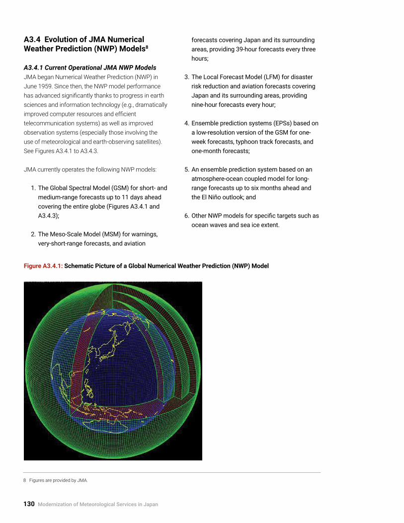
130 Modernization of Meteorological Services in Japan
A3.4 Evolution of JMA Numerical Weather Prediction (NWP) Models8
A3.4.1 Current Operational JMA NWP ModelsJMA began Numerical Weather Prediction (NWP) in June 1959. Since then, the NWP model performance has advanced significantly thanks to progress in earth sciences and information technology (e.g., dramatically improved computer resources and efficient telecommunication systems) as well as improved observation systems (especially those involving the use of meteorological and earth-observing satellites). See Figures A3.4.1 to A3.4.3.
JMA currently operates the following NWP models:
1 . The Global Spectral Model (GSM) for short- and medium-range forecasts up to 11 days ahead covering the entire globe (Figures A3 .4 .1 and A3 .4 .3);
2 . The Meso-Scale Model (MSM) for warnings, very-short-range forecasts, and aviation
forecasts covering Japan and its surrounding areas, providing 39-hour forecasts every three hours;
3 . The Local Forecast Model (LFM) for disaster risk reduction and aviation forecasts covering Japan and its surrounding areas, providing nine-hour forecasts every hour;
4 . Ensemble prediction systems (EPSs) based on a low-resolution version of the GSM for one-week forecasts, typhoon track forecasts, and one-month forecasts;
5 . An ensemble prediction system based on an atmosphere-ocean coupled model for long-range forecasts up to six months ahead and the El Niño outlook; and
6 . Other NWP models for specific targets such as ocean waves and sea ice extent .
Figure A3.4.1: Schematic Picture of a Global Numerical Weather Prediction (NWP) Model
8 Figures are provided by JMA.

Modernization of Observation and Forecasting Systems and Service Delivery in Japan 131
A3.4.2 Historical Evolution of JMA NWP Models9
Figure A3.4.2: Evolution of JMA NWP Models Since 1959
9 Figures are provided by JMA.

132 Modernization of Meteorological Services in Japan
A3.4.3 Data Coverage Maps for Global Analysis by NWP Models10
Figure A3.4.3: Data Coverage Maps for Global Analysis by NWP Models on 28 July 2015, 0000 UTC
10 Figures are provided by JMA.

Modernization of Observation and Forecasting Systems and Service Delivery in Japan 133
A3.5 Evolution of Typhoon Forecast in JMA11
A3.5.1 Historical Evolution of Typhoon Forecast in JMA
Table A3.5.1: Historical Evolution of Typhoon Forecast in JMA (Chronology). Numerals in square brackets indicate photographs and forecast charts in Figure A3.5.1.
11 Based on the information, figures, and photos provided by JMA.

134 Modernization of Meteorological Services in Japan
Figure A3.5.1: Collection of Photographs and Forecast Charts Related to Typhoon Forecast

Modernization of Observation and Forecasting Systems and Service Delivery in Japan 135
A3.5.2 Damage by Typhoon Vera (T5915) in 1959
Figure A3.5.2: Collection of Photographs by Nagoya Local Meteorological Office (LMO) Damage by Typhoon Vera (T5915) in 1959

136 Modernization of Meteorological Services in Japan
Figure A3.5.2: (Continued)

Modernization of Observation and Forecasting Systems and Service Delivery in Japan 137
A3.5.3 Example of Seamless Early Warning Services/Standard Operating Procedures for Super Typhoons in Nagoya LMO12
Figure A3.5.3: Standard Operating Procedures (Right) for Seamless Warning Services for Possible Super Typhoons Based on Experiences of Typhoon Vera (T5915) in 1959 (Left) and the Latest Early Warning Systems. Abridged Procedures in Nagoya Local Meteorological Office (LMO)
12 Based on the experience of Typhoon Vera (T5915) and the latest early warning systems (diagram (in Japanese) provided by JMA with English translation).

138 Modernization of Meteorological Services in Japan
A3.6 Risk-Based Early Warning Services in JMA
A3.6.1 Historical Evolution of JMA Warning Services
Figure A3.6.1: Evolution of JMA Warning Services through Revision of Warning Criteria Based on the diagram (in Japanese) provided by JMA

Modernization of Observation and Forecasting Systems and Service Delivery in Japan 139
A3.6.2 Early Warnings at the Municipality Level
Figure A3.6.2: Improvement in Early Warnings at the Municipality Level During the Last Decade (provided by JMA)
A3.6.3 Soil-water Index and Run-off Index13
Soil-water IndexThe soil-water index shows the risk of landslides, and is estimated from Radar/Rain gauge-Analyzed Precipitation (QPE) and Very-short-range Forecasting of Precipitation (QPF) using a simulation model (see Figure A3.6.3 on page 140). Higher indices indicate an increased risk of landslides. Landslide occurrence can be influenced by rainfall several days before.
Soil-water indices are calculated for individual 5-km grid squares, totaling approximately 16,000 grids covering the whole nation, and are used as criteria for heavy rain warnings/advisories issued by local meteorological offices (LMOs), for Landslide
Alert Information issued by LMOs with prefectural governments, and as the basis for real-time landslide risk maps publicized through the JMA website (http://www.jma.go.jp/en/doshamesh/).
Run-off IndexThe run-off index is estimated from QPE/QPF using a simple simulation model of rainfall and down-flow, and shows the impact of rainfall in the upper river basin to the downstream area (see Figure A3.6.4 on page 140).
Run-off indices are used as criteria for flood warnings/advisories issued by LMOs.
13 Based on the information provided by JMA.

140 Modernization of Meteorological Services in Japan
Figure A3.6.3: Schematic Diagram of Soil-water Index and a Photo of Landslide
Figure A3.6.4: Schematic Diagram of Run-off Index

Modernization of Observation and Forecasting Systems and Service Delivery in Japan 141
A3.7 Early Warning Services for Earthquake and Tsunami
A3.7.1 Modernization of Observation/Monitoring Systems and Early Warning ServicesThrough a similar historical evolution in weather observation and information systems, the modernization of monitoring systems for earthquakes and tsunamis has progressed from manned on-site observations at LMOs and weather offices to remote monitoring systems at regional HQs. The latest systems were centralized in Tokyo with the redundant systems at Osaka in 2009. See Table A3.7.1 and Photo A3.7.1.
Early Warning Services for Earthquake and TsunamiTo cope with the repeated tragic disasters caused by tsunami in Japan, the early warning services have been requested to maximize the time available for evacuation from tsunami generated by earthquakes in the near coasts of Japan, that is, to more promptly
issue tsunami warning after earthquakes. This challenge is a scientific/technical fight against time (Figure A3.7.1 on page 142).
JMA initiated tsunami warning services for the whole area of Japan in 1952. Warnings were issued within 20 minutes after earthquake through the following process: manned observations at LMOs, reports to regional HQs, earthquake analyses, and provision of the warnings. The time interval between the earthquake and the warning has become shorter and shorter through long and continuous endeavors to modernize the observation/monitoring systems. In the latest early warning services, after the detection of earthquake tremors, Earthquake Early Warnings (EEWs) are issued within a matter of seconds, with the seismic intensity information within 1.5 to 2 minutes, and tsunami warnings within 2 to 3 minutes (see Figures A3.7.2 to A3.7.5 on following pages).
Year Event
1941 Tsunami warning organization for the Sanriku coast established
1952 (1st )Introduction of tsunami warning services for the whole of Japan by the Central Meteorological Observatory (predecessor of JMA)
1960 Tsunami disaster with 142 casualties (dead/missing) triggered by the Chilean Earthquake of magnitude 9.5
1982 (2nd and/or 3rd)
Computerization of operation in tsunami warning services using the Local Automated Data Editing and Switching System (L-ADESS)
1983Tsunami disaster with 104 casualties triggered by the 1983 Central Sea of Japan Earthquake of magnitude 7.7 (Tsunami attacked the coast seven minutes after the quake.)
1987 (3rd) Introduction of the Earthquake Phenomena Observation System (EPOS)
1993Tsunami disaster with 202 casualties triggered by the 1993 Earthquake off the Southwest coast of Hokkaido of magnitude 7.8 (Tsunami attacked the coast within a few minutes after the quake.)
1994Introduction of the nationwide seismometer network for early detection of earthquake accompanying tsunami
1999 Introduction of tsunami warning system based on quantitative simulation techniques and database
2006 Utilization of the Earthquake Early Warning (EEW) in the operation of tsunami warning services
2009–2011 (4th)
Introduction of a centralized system in the JMA HQ with the redundant systems at Osaka Regional HQ
2011Tragic tsunami damage of almost 20,000 casualties caused by the 2011 Great East Japan Earthquake of magnitude 9.0
2013 Improvement of tsunami warnings based on experiences of the 2011 Great East Japan Earthquake
Table A3.7.1: Chronology of Tsunami Warnings. The Numbers in Parentheses Show the Corresponding Stage of Modernization as in Table 1.1.
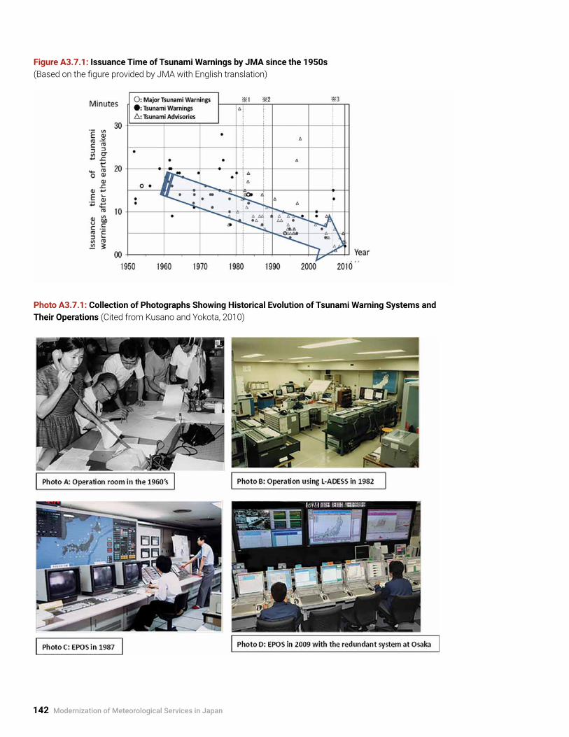
142 Modernization of Meteorological Services in Japan
Figure A3.7.1: Issuance Time of Tsunami Warnings by JMA since the 1950s (Based on the figure provided by JMA with English translation)
Photo A3.7.1: Collection of Photographs Showing Historical Evolution of Tsunami Warning Systems and Their Operations (Cited from Kusano and Yokota, 2010)

Modernization of Observation and Forecasting Systems and Service Delivery in Japan 143
A3.7.2 Current Seismometer and Seismic Intensity Meter Network
Figure A3.7.2: Current Seismometer and Seismic Intensity Meter Network (more than 4,000 sites) Upper left: Monitoring at JMA HQ; Upper right: Seismic intensity meter (left) and seismometer (right) (provided by JMA)
JMA (622)Local Governments (2,912)NIED (777)
Southern Part of the Ryukyu Islands
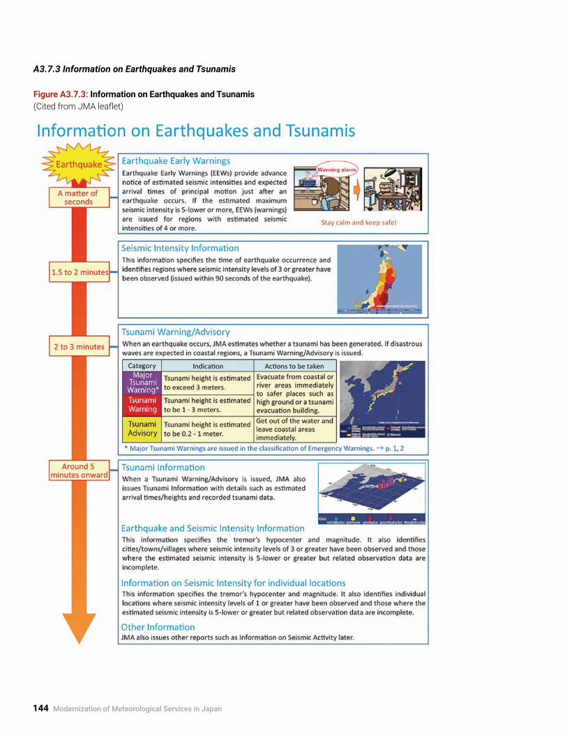
144 Modernization of Meteorological Services in Japan
A3.7.3 Information on Earthquakes and Tsunamis
Figure A3.7.3: Information on Earthquakes and Tsunamis (Cited from JMA leaflet)

Modernization of Observation and Forecasting Systems and Service Delivery in Japan 145
Figure A3.7.4: JMA Seismic Intensity (Cited from JMA leaflet)

146 Modernization of Meteorological Services in Japan
Figure A3.7.5: Tsunami Warnings and Action to be Taken (Cited from JMA leaflet)
• Tsunamis may hit before warnings are issued if the source region is near the coast. Be sure to evacuate when shaking occurs.
• Tsunami heights may exceed estimations due to coastal topography and other factors in some regions. Evacuate to higher ground.
• Tsunami Forecasts (Slight Sea Level Change) are issued if the estimated tsunami height is less than 20 cm and no damage is expected, or if slight sea level changes are expected after Tsunami Advisories are cleared.

Modernization of Observation and Forecasting Systems and Service Delivery in Japan 147
A3.8 Observation and Early Warning Services for Volcanic Activities14
A3.8.1 Volcanic Observation and Warning systemJMA issues volcanic forecasts and warnings for 110 active volcanoes in Japan (Figures A3.8.1 and A3.8.2). Warning systems with five volcanic alert levels are set in 37 active volcanoes (as of July 2016) as part of the planning for evacuation in coordination and collaboration with relevant authorities (Table A3.8.1 on page 148).
Furthermore, JMA issues (1) forecasts of volcanic ash dispersion and fall to land with amounts (Table A3.8.2 and Figure A3.8.3 on following pages); (2) forecasts of dispersion of and areas affected by volcanic gas such as sulfur dioxide; and (3) Eruption Notices to provide information on volcanic eruptions immediately after their occurrence.
14 Based on the information provided by JMA.
Active volcanoes in Japan
Eruption of Mt. Shinmoedake in 2011
Figure A3.8.1: Typical Observation System for Volcanic Activities
Figure A3.8.2: Location of 110 Active Volcanoes in Japan and 4 Volcanic Observations and Information Centers, and Eruption of Mt. Shinmoedake in 2011

148 Modernization of Meteorological Services in Japan
Table A3.8.1: Classification of Early Warning for Volcanic Activities (provided by JMA)
Volcanic Warning System (for volcanoes where volcanic alert levels are applied)

Modernization of Observation and Forecasting Systems and Service Delivery in Japan 149
Table A3.8.2: Ash Quality Categories for Volcanic Ash Fall Forecasts (provided by JMA)

150 Modernization of Meteorological Services in Japan
A3.8.2 Example of Volcanic Ash Fall Forecasts15 Kuchinoerubujima Island to the south of Kyushu erupted on 29 May 2015, 0959 JST, and the plumes rose as high as 9,000 m. The JMA HQ issued ash fall forecasts (bulletin and graphical forms) immediately after eruption (see Figure A3.8.3).
1 . 1009 JST (10 minutes after the eruption): one-hour forecast, and
2 . 1025 JST (26 minutes after the eruption): one- to six-hour forecasts at one-hour intervals .
Kuchinoerabujima IslandLatitude: 30° 26’ 36” NLongitude: 130° 13’ 02” ESummit Elevation: 657 meters
15 Based on the information on the JMA website.
Figure A3.8.3: Kuchinoerabujima Island and Eruption with Pyroclastic Flows, and Examples of Volcanic Ash Fall Forecasts (Photo taken at 1002 JST, 29 May 2015, three minutes after the eruption)

Modernization of Observation and Forecasting Systems and Service Delivery in Japan 151
A3.9 Oceanographic and Marine Meteorological Observations and Related Services16
A3.9.1 Oceanographic Observation and Monitoring for Climate ServicesJMA conducts various kinds of oceanographic observations for climate services, including global environment monitoring, using research vessels, drifting buoys, and profiling floats from the sea surface to the deep sea (Figure A3.9.1). It also uses the geostationary meteorological satellite Himawari-8 and earth-observing satellites to provide spatial information for the Pacific and on a global scale.
JMA operates two research vessels in the northwestern Pacific, which mainly monitor large-scale, long-term variations in ocean environment, including global warming, in cooperation with international observation programs. JMA also participates in the
Argo Project, which uses profiling floats to gather information on oceans and which is conducted under WMO, UNESCO/IOC, and other related institutions. Profiling floats observe water temperature and salinity from the sea surface to deep water (water depth about 2,000 m). JMA also operates the Japan Argo Data Assembly Center for international data exchange.
Based on the above observations, JMA provides a variety of oceanographic information on variations and changes in oceanic conditions (sea surface temperature, current, sea-level, carbon dioxide, ocean acidification, etc.). Further, JMA monitors and predicts El Niño and La Niña events, which are related to climate variability in the world as well as in Japan.
16 Figures and photos are from the JMA website.
Figure A3.9.1: JMA’s Oceanographic and Atmospheric Environment Observations Network (left), JMA Research Vessel (Ryofu Maru) (right bottom), and Ocean Data Buoy and Argo Float (right top)
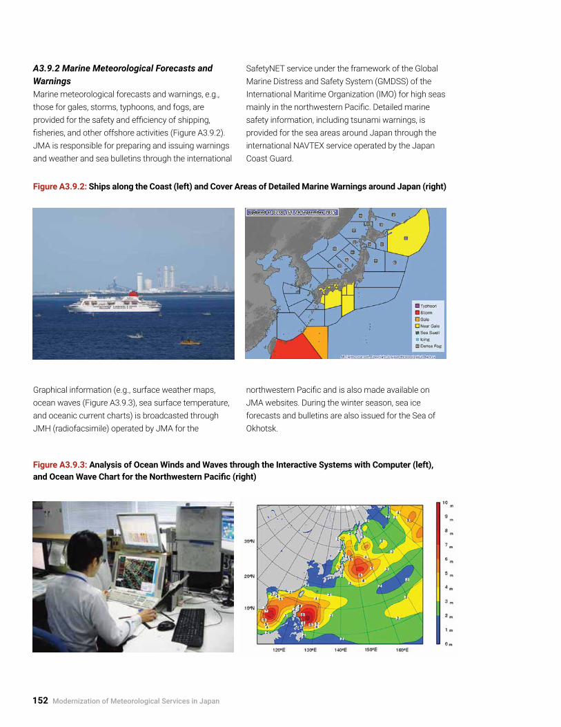
152 Modernization of Meteorological Services in Japan
A3.9.2 Marine Meteorological Forecasts and WarningsMarine meteorological forecasts and warnings, e.g., those for gales, storms, typhoons, and fogs, are provided for the safety and efficiency of shipping, fisheries, and other offshore activities (Figure A3.9.2). JMA is responsible for preparing and issuing warnings and weather and sea bulletins through the international
SafetyNET service under the framework of the Global Marine Distress and Safety System (GMDSS) of the International Maritime Organization (IMO) for high seas mainly in the northwestern Pacific. Detailed marine safety information, including tsunami warnings, is provided for the sea areas around Japan through the international NAVTEX service operated by the Japan Coast Guard.
Figure A3.9.2: Ships along the Coast (left) and Cover Areas of Detailed Marine Warnings around Japan (right)
Graphical information (e.g., surface weather maps, ocean waves (Figure A3.9.3), sea surface temperature, and oceanic current charts) is broadcasted through JMH (radiofacsimile) operated by JMA for the
northwestern Pacific and is also made available on JMA websites. During the winter season, sea ice forecasts and bulletins are also issued for the Sea of Okhotsk.
Figure A3.9.3: Analysis of Ocean Winds and Waves through the Interactive Systems with Computer (left), and Ocean Wave Chart for the Northwestern Pacific (right)

Modernization of Observation and Forecasting Systems and Service Delivery in Japan 153
A3.10 Typical NHK TV Broadcasts during Severe Weather Events
Japanese TV broadcasters, both public (Japan Broadcasting Corporation (NHK)) and private, broadcast weather and climate information in a variety of creative programs (see also Section 3.2.1 and Box 4.3). When higher disaster risks are predicted by JMA forecasts due to typhoon and other severe weather events, NHK (see Photo A3.10.1) and private broadcasters expand their weather-related programs to draw public attention to preparedness, specifically through the following:
• Special commentary on ordinary TV news and weather forecast programs;
• Weather warnings and bulletins displayed as on-screen titles on ordinary programs; and
• Special programs provided by extending news programs and/or interrupting/cancelling ordinary programs .
Photo A3.10.1: Typical TV Screens from NHK for Severe Events Relating to Typhoon and Heavy Rain (Courtesy of NHK)
(a) Commentary by a skillful certified weather forecaster showing the dynamic movement of heavy rain observed by the JMA weather radar network.
(b) Map showing latest location and size of typhoon. (Upper left: Specifics of typhoon; top: issuance of an evacuation advisory for 18,945 households by mayor of Kyoto City; top right: issuance of heavy rain emergency warning for three prefectures.)
(c) Map showing latest information on the typhoon track forecast. (Upper left: Specifics of typhoon; top: issuance of an evacuation advisory for 18,945 households by mayor of Kyoto City.)
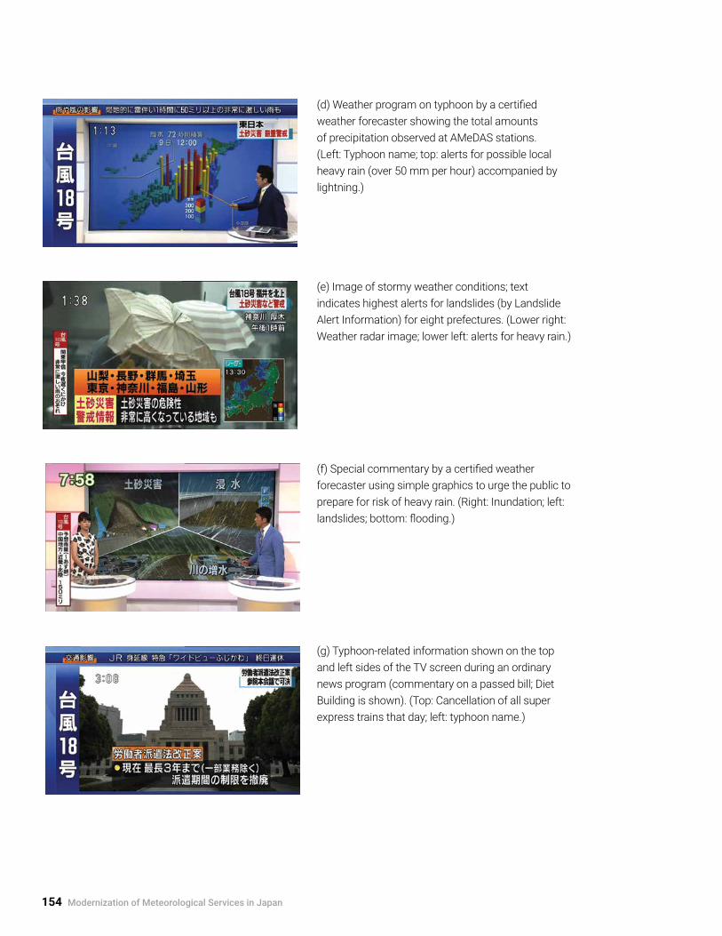
154 Modernization of Meteorological Services in Japan
(d) Weather program on typhoon by a certified weather forecaster showing the total amounts of precipitation observed at AMeDAS stations. (Left: Typhoon name; top: alerts for possible local heavy rain (over 50 mm per hour) accompanied by lightning.)
(e) Image of stormy weather conditions; text indicates highest alerts for landslides (by Landslide Alert Information) for eight prefectures. (Lower right: Weather radar image; lower left: alerts for heavy rain.)
(f) Special commentary by a certified weather forecaster using simple graphics to urge the public to prepare for risk of heavy rain. (Right: Inundation; left: landslides; bottom: flooding.)
(g) Typhoon-related information shown on the top and left sides of the TV screen during an ordinary news program (commentary on a passed bill; Diet Building is shown). (Top: Cancellation of all super express trains that day; left: typhoon name.)

Evolution of the Public-Private Partnership 155
4. Evolution of the Public-Private Partnership
A4.1 Weather Observations Performed by Persons Other Than JMA and Verification of Instruments
A4.1.1 Chronology
Table A4.1.1: Evolution of Institutional Framework for Weather Observations by Persons Other Than JMA
Year Event
1920sEstablishment of the predecessor of Meteorological Instrument Center (MIC) in the Central Meteorological Observatory (predecessor of JMA)
1952Establishment of the legal framework (Meteorological Service Act) for the standards of meteorological observations by persons other than JMA and verification of instruments by JMA
1953Establishment of the Japan Association of Meteorological Instrument Engineering (JAMIE) in the private manufacturing sector
1997Designation of the Meteorological Instrument Center of JMA as the WMO Regional Instrument Centre (RIC) of RA II (Asia)
2002Amendment to the Act to transfer the implementation of instrument verifications from JMA to the authorized body of non-profit foundation (“designated verification body”); authorization of JMBSC as the designated verification body
2004Amendment to the Act to transfer from “designated verification body” to “registered verification body”; authorization of JMBSC as the registered verification body
A4.1.2 Weather Observations Other Than by JMAAs of January 2015, there were about 28,000 observation sites operated by persons other than JMA that met technical standards and reported the site information to JMA (as specified in the Meteorological Service Act). The sites are broken down in Figure A4.1.1 (cited from JMA (2015b) with English translation).
A4.1.3 Number of Instrument VerificationsJMBSC was designated as the verification body for meteorological instruments by JMA in October 2002. It annually issues around 12,000 inspection certificates for meteorological instruments (Figure A4.1.2 on next page).
Figure A4.1.1: Notified Weather Observation Sites by Persons Other Than JMA in Compliance with Technical Standards
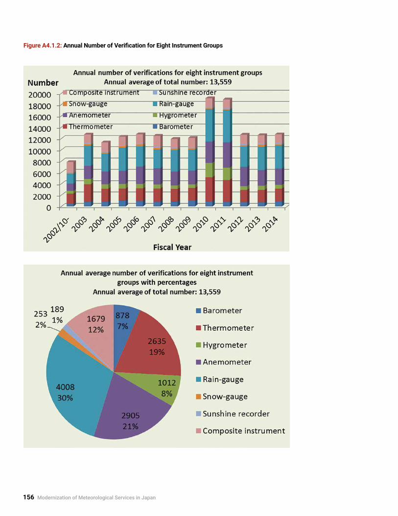
156 Modernization of Meteorological Services in Japan
Figure A4.1.2: Annual Number of Verification for Eight Instrument Groups

Experiences in International Programs and Projects 157
5. Experiences in International Programs and Projects
A5.1 International Roles of JMA and Areas of Responsibility17
A5.1.1 World and Regional Centers
Table A5.1.1: World and Regional Centers Operated by JMA
Weather monitoring and forecasting
Operation of and data dissemination for geostationary meteorological satellites (1978–) Asia, Pacific
WMO Global Data-processing and Forecasting System (GDPFS) Regional Specialized Meteorological Centre (RSMC) (1968–) East Asia
WMO RSMC Tokyo–Typhoon Center (1988–) East Asia
ICAO Tropical Cyclone Advisory Centre (TCAC) (1993–) Asia, Pacific
ICAO Volcanic Ash Advisory Centre (VAAC) (1997–) Asia, Pacific
WMO RSMC on the Atmospheric Transport Modelling (1997–) Asia
WMO Lead Centre for Verification of Ensemble Prediction System (2005–) World
Telecommunication and observation systems
WMO Information System (WIS) Global Information System Centre (GISC) (2011–) Asia
WMO Global Telecommunication System (GTS) Regional Telecommunication Hub (RTH) (1968–) East Asia
WMO Regional Radiation Centre (RRC) of RA II (1965–) Asia
WMO Lead Centre for Monitoring Quality of Land Surface Observations in RA II (1991–) Asia
WMO Regional Instrument Centre (RIC) of RA II (1997–) Asia
GCOS Surface Network (GSN) Monitoring Centre (1999–) World
Environment, climate, and ocean
WMO Global Atmosphere Watch (GAW) World Data Centre for Greenhouse Gases (WDCGG) (1990–) World
WMO GAW Quality Assurance/Science Activity Centre (QA/SAC) (1995–) Asia, Southwest Pacific
WMO GAW World Calibration Centre (WCC) (2002–) Asia, Southwest Pacific
Tokyo Climate Center (2002–) as WMO Regional Climate Centre (RCC) (2009–) Asia, Pacific
WMO Global Producing Centre for Long-range Forecasts (GPC) (2007–) World
North-East Asian Regional Global Ocean Observing System (Near-GOOS) Regional Real-time Database (1996–) Northeast Asia
National Data Centre for ARGO (Array for Real-time Geostrophic Oceanography) Program (2002–) Northwest Pacific
Tsunami
Northwest Pacific Tsunami Advisory Center (2005–) Northwest Pacific
17 Provided by JMA.

158 Modernization of Meteorological Services in Japan
A5.1.2 WMO Regional Associations Six Regional Associations (RAs) are responsible for the promotion and coordination of meteorological, hydrological, and related activities within their respective regions: Region I (Africa), Region II (Asia), Region III (South America), Region IV (North America, Central America, and the Caribbean), Region V (South-West Pacific), and Region VI (Europe).
Figure A5.1.1: WMO Regions (Cited from WMO Basic Documents No. 1, 2015 edition)

Experiences in International Programs and Projects 159
A5.2 Case Studies for Experiences in International Programs and Projects
A5.2.1 Tokyo Climate Center (TCC)–Regional Climate Centre (Tokyo)
Figure A5.2.1: Activities of Tokyo Climate Center (TCC) in support of NMHSs in the Asia-Pacific Region: (a) Schematic Diagram, (b) Example of Climate Information, and (c) Photo of Annual Training Seminar
(a)
(b) (c)

160 Modernization of Meteorological Services in Japan
Evolution of Climate ServicesAs identified in the WMO-led Global Framework for Climate Services (GFCS), climate services are essential for health, food security, water resources management, energy, and disaster risk reduction. In the last several decades, National Meteorological Services (NMSs) in developed countries—including JMA as the leading global center for NWP models—have extensively developed climate prediction models and introduced or initiated NWP-based seasonal forecasts as well as research on the prediction of climate change due to global warming. Based on advances in climate observation and prediction techniques, the World Climate Conference-3 (WCC-3) decided to establish the GFCS in 2009 to enable society to better manage the risks and opportunities arising from climate variability and change. NMHSs and other international groups and communities now set about collaborative dialogues to deliver scientific climate information to various socio-economic sectors.
Good Practices of Tokyo Climate Center (TCC) to Support Developing Countries18
JMA established the Tokyo Climate Center (TCC) in 2002 to facilitate its regional support for climate
services of NMHSs in the Asia-Pacific region. TCC was designated as one of the first WMO Regional Climate Centres (RCCs) in Region II (Asia) in 2009, and it has continued to deliver regional climate services by providing and enhancing data and products, holding training seminars, sending experts to various NMHSs, and hosting visitors. Figure A5.2.1 on previous page summarizes the activities of TCC.
Among these activities, TCC especially focuses on capacity development of climate experts (meteorologists) in NMHSs who handle fundamental products of climate models and analyses, which JMA provides via the TCC website (http://ds.data.jma.go.jp/tcc/tcc/index.html) for the issuance of climate information specific to users’ national requirements. TCC holds annual training seminars on the application of its climate monitoring and prediction products and has trained more than 100 meteorologists from 24 WMO Members since 2008. TCC also arranges JMA expert visits to and hosts visitors from NMHSs for exchange of views on climate services and effective knowledge transfer. Through the conduct of such medium-term activities, the users of TCC websites are growing each year, as shown in Figure A5.2.2.
Figure A5.2.2: Weekly Page Views of the TCC Websites of JMA from July 2004 to December 2014
18 TCC services to NMHSs in the Asia-Pacific region are detailed in the JMA website: http://ds.data.jma.go.jp/tcc/tcc/index.html.
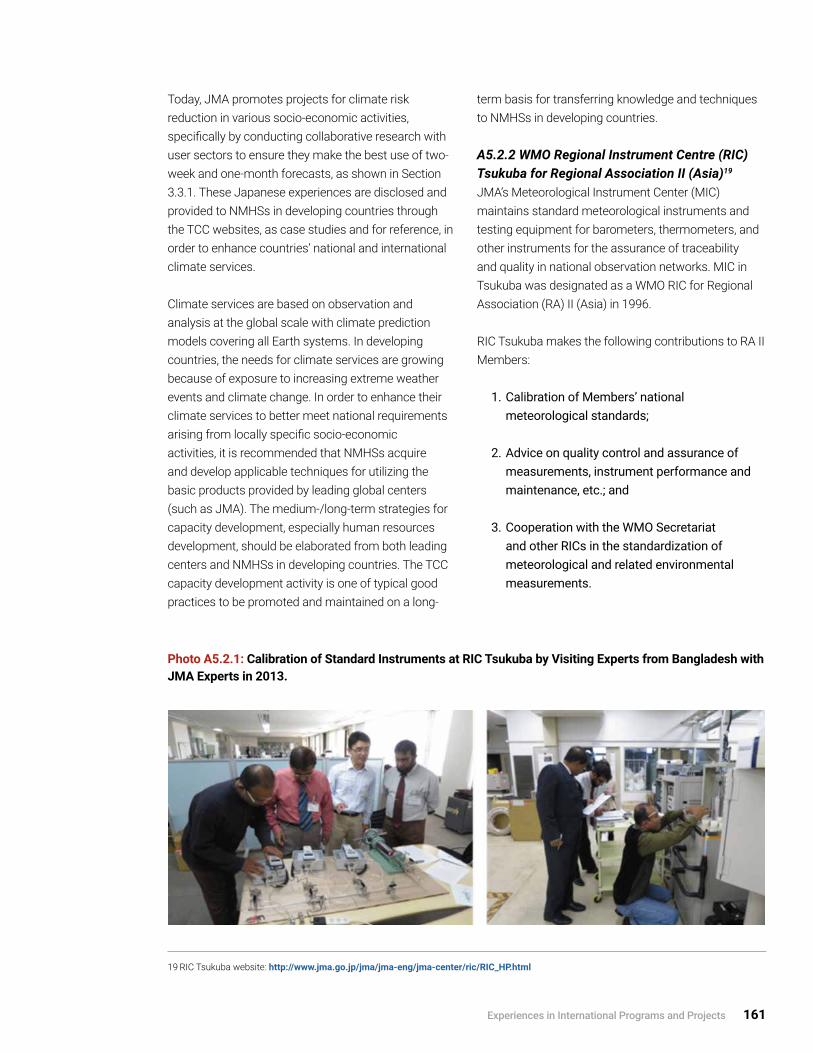
Experiences in International Programs and Projects 161
19 RIC Tsukuba website: http://www.jma.go.jp/jma/jma-eng/jma-center/ric/RIC_HP.html
Today, JMA promotes projects for climate risk reduction in various socio-economic activities, specifically by conducting collaborative research with user sectors to ensure they make the best use of two-week and one-month forecasts, as shown in Section 3.3.1. These Japanese experiences are disclosed and provided to NMHSs in developing countries through the TCC websites, as case studies and for reference, in order to enhance countries’ national and international climate services.
Climate services are based on observation and analysis at the global scale with climate prediction models covering all Earth systems. In developing countries, the needs for climate services are growing because of exposure to increasing extreme weather events and climate change. In order to enhance their climate services to better meet national requirements arising from locally specific socio-economic activities, it is recommended that NMHSs acquire and develop applicable techniques for utilizing the basic products provided by leading global centers (such as JMA). The medium-/long-term strategies for capacity development, especially human resources development, should be elaborated from both leading centers and NMHSs in developing countries. The TCC capacity development activity is one of typical good practices to be promoted and maintained on a long-
term basis for transferring knowledge and techniques to NMHSs in developing countries.
A5.2.2 WMO Regional Instrument Centre (RIC) Tsukuba for Regional Association II (Asia)19
JMA’s Meteorological Instrument Center (MIC) maintains standard meteorological instruments and testing equipment for barometers, thermometers, and other instruments for the assurance of traceability and quality in national observation networks. MIC in Tsukuba was designated as a WMO RIC for Regional Association (RA) II (Asia) in 1996.
RIC Tsukuba makes the following contributions to RA II Members:
1 . Calibration of Members’ national meteorological standards;
2 . Advice on quality control and assurance of measurements, instrument performance and maintenance, etc .; and
3 . Cooperation with the WMO Secretariat and other RICs in the standardization of meteorological and related environmental measurements .
Photo A5.2.1: Calibration of Standard Instruments at RIC Tsukuba by Visiting Experts from Bangladesh with JMA Experts in 2013.

162 Modernization of Meteorological Services in Japan
In the last five years, RIC Tsukuba has calibrated national meteorological standards for six Members: Bangladesh; Fiji; Hong Kong, China; Indonesia; Oman; and Thailand. In JICA’s technical cooperation projects, RIC Tsukuba supported the calibration for Bangladesh (Photo A5.2.1 on previous page), Fiji, Mozambique, and Sri Lanka.
Furthermore, the center has organized training workshops for instrument specialists from Member states, and has contributed to improving the quality and reliability of meteorological observational data in RA II, as shown in Photo A5.2.2.
Key Lessons Learned from the RIC Tsukuba ActivitiesA certain number of NMHSs in RA II (Asia) carry out meteorological observations using instruments whose maintenance and repair is incomplete, calling into question the traceability of their measurements. A survey on meteorological instruments, calibration, and training in RA II carried out by WMO in December 2011 indicated that less than half of Members have standards traceable to international ones, and many NMHSs have certain concerns about the quality of their observation data.
Sustainable technical support at all levels—from fundamental to advanced—should be provided by developed countries and the regional centres of WMO.
Photo A5.2.2: JMA/WMO Training Workshop on Calibration and Maintenance of Meteorological Instruments in RA II (Asia) (February 2013). Experts from 14 countries participated.

Contents 163
Annex (B) Others
Annex B 163

164 Modernization of Meteorological Services in Japan
B1. Abbreviations
ADESS Automated Data Editing and Switching System (JMA)
AFTN Aeronautical Fixed Telecommunication Network (ICAO)
AMeDAS Automated Meteorological Data Acquisition System (JMA)
ANA All Nippon Airways (Japan)
ATMC Air Traffic Management Center (CAB/MLIT)
ATMetC Air Traffic Meteorology Center (JMA)
AWS automatic weather station
AWSC Aviation Weather Service Center (JMA)
CAB Civil Aviation Bureau (MLIT)
CIMO Commission for Instruments and Methods of Observation (WMO)
CMO Central Meteorological Observatory (Predecessor of JMA)
COSMETS Computer System for Meteorological Services (JMA)
DCP Data Collection Platform (Himawari/JMA)
DCPC Data Collection or Production Centre (WIS/WMO)
DCS Data Collection System (Himawari/JMA)
DRR disaster risk reduction
EB exabyte
EEW Earthquake Early Warning (JMA products)
EPOS Earthquake Phenomena Observation System (JMA)
EPS Ensemble Prediction System (NWP model/JMA)
ESCAP United Nations Economic and Social Commission for Asia and the Pacific
EWS Early Warning System
FDMA Fire and Disaster Management Agency (MIC, Japan)
GAW Global Atmosphere Watch (WMO)
GDPFS Global Data-processing and Forecasting System (WMO)
GFCS Global Framework for Climate Services (WMO)
GFDRR Global Facility for Disaster Reduction and Recovery (WB)
GIS Geographic Information System
GISC Global Information System Centre (WIS/WMO)
GMDSS Global Marine Distress and Safety System (IMO)
GMS geostationary meteorological satellite (GMS to GMS-5 (Himawari to Himawari-5), JMA)
GMSS GMS System (GMS/JMA)
GNSS Global Navigation Satellite Systems
GPS Global Positioning System
GSM Global Spectral Model (NWP model/JMA)
GTS Global Telecommunication System (WMO)
Himawari Geostationary meteorological satellites operated by JMA
HOPE Himawari Operation Enterprise Corporation
HQ Headquarters
HRPN High-resolution Precipitation Nowcast (JMA products)
ICAO International Civil Aviation Organization
ICT information and communications technology
IMO International Maritime Organization
IMO International Meteorological Organization (Predecessor of WMO)
INDiP Information Network for Disaster Prevention (JMA)
IOC Intergovernmental Oceanographic Commission (UNESCO)
IPCC Intergovernmental Panel on Climate Change
IT information technology
JAMIE Japan Association of Meteorological Instrument Engineering (private manufacturers)

Contents 165
JAXA Japan Aerospace Exploration Agency
JCG Japan Coast Guard (MLIT)
JDDS JMA Data Dissemination System (“Himawari-8”, JMA)
JICA Japan International Cooperation Agency
JMA Japan Meteorological Agency (MLIT)
JMBSC Japan Meteorological Business Support Center
JMH Radio-facsimile broadcast of weather information (JMA)
JWA Japan Weather Association (private weather service company)
L-ADESS Local ADESS (Automated Data Editing and Switching System, JMA)
LFM Local Forecast Model (NWP model/JMA)
LMO local meteorological office (JMA)
MAFF Ministry of Agriculture, Forestry and Fisheries (Japan)
MEXT Ministry of Education, Culture, Sports, Science and Technology (Japan)
MIC Meteorological Instrument Center (JMA)
MIC Ministry of Internal Affairs and Communications (Japan)
MIF Meteorological Instrument Factory of CMO (JMA)
MLIT Ministry of Land, Infrastructure, Transport and Tourism
MoC Ministry of Construction (reorganized into MLIT)
MOFA Ministry of Foreign Affairs (Japan)
MoT Ministry of Transport (reorganized into MLIT)
MRI Meteorological Research Institute (JMA)
MSC Meteorological Satellite Center (JMA)
MSM Meso-Scale Model (NWP model/JMA)
MTSAT Multi-functional Transport Satellite (with geostationary meteorological satellite function and aviation control function, MTSAT-1R/-2 (Himawari-6/7), JMA and CAB of MLIT)
NAPS Numerical Analysis and Prediction System (JMA)
NARO National Agriculture and Food Research Organization (Japan)
NAVTEX International maritime information service (IMO/IHO Worldwide Navigation Warning Service (WWNWS); IHO: International Hydrographic Organization )
NC National Centre (WIS/WMO)
NHK Japan Broadcasting Corporation
NHS National Hydrological Service (WMO)
NIED National Research Institute for Earth Science and Disaster Prevention (Japan)
NMHS National Meteorological and Hydrological Service (WMO)
NMS National Meteorological Service (WMO)
NREN National Research and Education Network (Japan)
NTT Nippon Telegraph and Telephone Corporation (Japan)
NWP Numerical Weather Prediction
NWW National Weather Watch (JMA)
ODA official development assistance
PAGASA Philippine Atmospheric, Geophysical and Astronomical Services Administration
PPP public-private partnership
PR Permanent Representative (of a Member with WMO)
QPE Quantitative Precipitation Estimation (JMA)
QPF Quantitative Precipitation Forecast (JMA)
RA Regional Association (WMO)
R&D research and development
RCC Regional Climate Centre (WMO)
RIC Regional Instrument Centre (WMO)
RSMC Regional Specialized Meteorological Centre (WMO)
RTH Regional Telecommunication Hub (GTS/WMO)
SafetyNET International maritime information services for high sea (GMDSS/IMO)
SATAID Satellite Animation and Interactive Diagnosis (Himawari/JMA)
SIGMET Significant Meteorological Information (aviation)
SNS Social Networking Service
SSWS Storm Surge Watch Scheme (WMO)
TC Tropical Cyclone
TCC Tokyo Climate Center (JMA)
Abbreviations 165

166 Modernization of Meteorological Services in Japan
TEPCO Tokyo Electric Power Company
TMO Tokyo Meteorological Observatory (Predecessor of CMO and JMA)
UNESCO United Nations Educational, Scientific and Cultural Organization
VAA Volcanic Ash Advisory
VAAC Volcanic Ash Advisory Centre (JMA, ICAO/WMO)
VCP Voluntary Cooperation Programme (WMO)
VOLMET Voice Language Meteorological Report (Short-wave radio broadcasting service for aircraft)
VSFP Very-short-range Forecasting of Precipitation (JMA product)
WCC-3 World Climate Conference-3
WINDAS Wind Profiler Network and Data Acquisition System (JMA)
WIS WMO Information System
WMC World Meteorological Centre (WMO)
WMO World Meteorological Organization
WWW World Weather Watch (WMO)

Contents 167
B2. References
JMA Websites Japan Meteorological Agency (JMA): http://www.jma.go.jp/jma/index.html
Meteorological Satellite Center (MSC)/JMA: http://www.jma-net.go.jp/msc/en/index.html
Regional Specialized Meteorological Centre (RSMC) Tokyo: http://www.jma.go.jp/jma/jma-eng/jma-center/rsmc-hp-pub-eg/RSMC_HP.htm
Regional Instrument Centre (RIC) Tsukuba: http://www.jma.go.jp/jma/jma-eng/jma-center/ric/RIC_HP.html
Tokyo Climate Center (TCC): http://ds.data.jma.go.jp/tcc/tcc/index.html
WMO Information System (WIS) portal site of GISC-Tokyo/JMA: http://www.wis-jma.go.jp/cms/
Government Authorities and Other Websites (mainly in English)Cabinet Office (Disaster Management): http://www.cao.go.jp/en/disaster.html
Fire and Disaster Management Agency (FDMA): http://www.fdma.go.jp/en/
Japan Coast Guard (JCG): http ://www.kaiho.mlit.go.jp/e/index_e.htm
Japan International Cooperation Agency (JICA): http://www.jica.go.jp/english/index.html
Japan Meteorological Business Support Center (JMBSC): http://www.jmbsc.or.jp/en/index-e.html
Japan Law Translation Websites of the Ministry of Justice:20 http://www.japaneselawtranslation.go.jp/law/?re=02 Ministry of Agriculture, Forestry and Fisheries (MAFF) : http://www.maff.go.jp/j/tokei/kouhyou/sakumotu/higai/gaiyou/index.html#1
Ministry of Foreign Affairs (MOFA): http://www.mofa.go.jp/index.html
Ministry of Internal Affairs and Communications (MIC): http://www.soumu.go.jp/english/index.html
Minister of Land, Infrastructure, Transport and Tourism (MLIT): http://www.mlit.go.jp/en/index.html
NHK (Japan Broadcasting Corporation) World: http://www3.nhk.or.jp/nhkworld/
Tokyo Electric Power Company (TEPCO): http://www.tepco.co.jp/forecast/index-j.html
WMO WebsiteWorld Meteorological Organization (WMO): https://www.wmo.int/pages/index_en.html
20 English translation of Japanese laws, including the Meteorological Service Act
References 167

168 Modernization of Meteorological Services in Japan
PublicationsCabinet Office (2015): Disaster management in Japan (brochure in Japanese and English), 52pp, publication and Cabinet Office website (http://www.bousai.go.jp/1info/pdf/saigaipamphlet_je.pdf)
Cabinet Office (2015b): White paper on disaster management 2015 (in Japanese), 262pp, publication and Cabinet Office website (http://www.bousai.go.jp/kaigirep/hakusho/h27/)
FDMA (2014): White paper on fire prevention 2014 (in Japanese), 339pp, publication and FDMA website (http://www.fdma.go.jp/html/hakusho/h26/h26/index.html)
Hasegawa, N., S. Harada, S. Tanaka, S. Ogawa, A. Goto, Y. Sasagawa and N. Washitake (2012): Multi-Hazard Early Warning System in Japan. Institutional Partnerships in Multi-Hazard Early Warning Systems (Maryam Golnaraghi, Ed.), Springer, 181–215.
JMA (1930–2015): Journal of Meteorological Services (Monthly Journal of JMA) (in Japanese)
JMA (1975): 100 Year’s History of Meteorological Services in Japan (in Japanese), 740pp
JMA (2012): Report on the 2011 Off the Pacific Coast of Tohoku Earthquake, Volumes I and II, Technical Report of the Japan Meteorological Agency, Vol. 133, 418 pp, (in Japanese with English abstract), publication and JMA website (http://www.jma.go.jp/jma/kishou/books/gizyutu/133/gizyutu_133.html)
JMA (2012b): Volcanoes—volcano monitoring and disaster mitigation (brochure in Japanese and English), 32pp, publication and JMA website (http://www.jma.go.jp/jma/kishou/books/kazan/kazan201208_1.pdf)
JMA (2013): Outline on the Operational Numerical Weather Prediction at the Japan Meteorological Agency (in English), March 2013, JMA website (http://www.jma.go.jp/jma/jma-eng/jma-center/nwp/outline2013-nwp/index.htm)
JMA (2013b): Lessons learned from the tsunami disaster caused by the 2011 Great East Japan Earthquake and improvements in JMA’s tsunami warning system (in English), JMA website (http://www.data.jma.go.jp/svd/eqev/data/en/tsunami/LessonsLearned_Improvements_brochure.pdf)
JMA (2014): Japan Meteorological Agency (brochure in English), 24pp, publication and JMA website (http://www.jma.go.jp/jma/en/Activities/brochure201403.pdf)
JMA (2014b): Report on Recent Climate Change in the World—Reviews and Outlooks for the Future (VIII), 253pp (in Japanese), publication and JMA website (http://www.data.jma.go.jp/cpdinfo/climate_change/)
JMA (2014c): Climate information for industrial operators (leaflet in English), 4pp, JMA website (http://www.data.jma.go.jp/gmd/risk/en/CRM_leaflet.pdf)
JMA (2015): Meteorological Services Today—Save Life, Nature and the Earth (Annual Report on Meteorological Services by JMA in Japanese), 177pp, publication and JMA website, http://www.jma.go.jp/jma/kishou/books/hakusho/2015/index.html)
JMA (2015b): JMA Guidebook 2015 (in Japanese), 310pp, publication and JMA website (http://www.jma.go.jp/jma/kishou/books/jma-guidebook/index.html)
JMA (2015c): Earthquake and Tsunami—Disaster prevention and mitigation efforts (brochure in Japanese and English), 26pp, publication and JMA website (http://www.jma.go.jp/jma/kishou/books/jishintsunami/index.html)
JMA (2015d): Assessment report on the utilization of and user-satisfaction with meteorological information (in Japanese), JMA website (http://www.jma.go.jp/jma/kishou/hyouka/manzokudo/manzokudo-index.htm)

Contents 169
JMA (2015e): Climate Change Monitoring Report 2014, JMA website (http://www.jma.go.jp/jma/en/NMHS/indexe_ccmr.html)
JMBSC (2015): Historical evolution of private meteorological services and of the data distribution services by JMBSC (in Japanese), Journal of Meteorological Services, Vol. 82, 81–114. (http://www.jma.go.jp/jma/kishou/books/sokkou/82/vol82p081.pdf)
Kusano, F., and Y. Yokota (2010): History of tsunami warning services (in Japanese), Quarterly Journal of Seismology (JMA), Vol. 74, 35–91. (http://www.jma.go.jp/jma/kishou/books/kenshin/vol74p035.pdf)
MIC (2015): White Paper 2015, Information and Communications in Japan (in Japanese and English), publication and MIC website (http://www.soumu.go.jp/johotsusintokei/whitepaper/index.html)
MLIT (2012): Report on the subsidence and inundation by the 2011 Great East Japan Earthquake (in Japanese), MLIT website (http://www.mlit.go.jp/common/000206397.pdf)
MOFA (2014): Japan’s ODA White Paper 2013, publication and MOFA website (http://www.mofa.go.jp/policy/oda/page_000017.html)
NHK (2014): NHK Annual Report 2014 (Radio & Television Year Book in Japanese), 753pp, publication and NHK website (https://www.nhk.or.jp/bunken/book/regular/nenkan/nenkan_2014.html)
NHK (2015): NHK Guideline on Broadcasting 2015 (in Japanese), 89pp, NHK website (http://www.nhk.or.jp/pr/keiei/bc-guideline/pdf/guideline2015.pdf)
NHK (2015b): NHK Annual Report 2015–2016 (in English), 15pp, publication and NHK website (http://www.nhk.or.jp/corporateinfo/english/publication/pdf/annual_report.pdf)
Nitta, T. ed. (2015): Encyclopedia of meteorological disasters, four seasons in Japan and their impacts and preventions (in Japanese), 558pp, Asakura Publishing Co., Ltd.
Rogers, David P., and Vladimir V. Tsirkunov (2013): Weather and Climate Resilience: Effective Preparedness through National Meteorological and Hydrological Services, World Bank, 141pp, http://dx.doi.org/10.1596/978-1-4648-0026-9.
Seki, T., T. Okada, M. Okada and T. Sugano (2008): Early Warning “Area Mail”, NTT Technical Review, Vol. 6, No. 12, 1–6. https://www.ntt-review.jp/archive/ntttechnical.php?contents=ntr200812sf2.pdf&mode=show_pdf
References 169

170 Modernization of Meteorological Services in Japan


Contact:
World Bank Disaster Risk Management Hub, TokyoPhone: +81-3-3597-1320Email: [email protected]: http://www.worldbank.org/drmhubtokyo
The World Bank Disaster Risk Management Hub, Tokyo supports developing countries to mainstream DRM in national development planning and investment programs. As part of the Global Facility for Disaster Reduction and Recovery and in coordination with the World Bank Tokyo Office, the DRM Hub provides technical assistance grants and connects Japanese and global DRM expertise and solutions with World Bank teams and government officials. Over 37 countries have benefited from the Hub’s technical assistance, knowledge, and capacity building activities. The DRM Hub was established in 2014 through the Japan-World Bank Program for Mainstreaming DRM in Developing Countries—a partnership between Japan’s Ministry of Finance and the World Bank.