models for gis governance · the gio is authorized by statute or executive order. geographic...
TRANSCRIPT

GIT GOVERNANCE State Models and Best Practices
Missouri
Prepared for Wisconsin Geographic Information Office
Wisconsin State Cartographer’s Office
Prepared by L. Shanley
Land Information & Computer Graphics Facility University of Wisconsin-Madison
APRIL 2007

GIT GOVERNANCE: STATE MODELS AND BEST PRATICES
The Wisconsin Geographic Information Office (GIO) has the responsibility to coordinate Wisconsin’s geospatial information activities, to implement standards to facilitate interoperability of information related to homeland security, to make recommendations on awarding grants to fund geospatial data, and to create information sharing agreements with state, local and tribal governments. The Wisconsin State Cartographer's Office (SCO) is a unit within the Department of Geography at the University of Wisconsin-Madison. With an outreach mission, the SCO gathers, maintains and disseminates information about mapping and geo-spatial data in the state. The Land Information & Computer Graphics Facility (LICGF) of the University of Wisconsin-Madison provides research, training, and outreach in the use of land and geographic information systems while focusing on land records modernization, land and natural resource management applications, and the use of information for land-use decision-making. The US Geological Survey (USGS) has realigned its spatial programs into a National Geospatial Program Office (NGPO), bringing The National Map, Geospatial One-Stop, and the Federal Geographic Data Committee into a single program office. With the creation of the NGPO, the essential components of delivering the National Spatial Data Infrastructure (NSDI) and capitalizing on the power of place will be managed as a unified portfolio that benefits the entire geospatial community. This state GIT governance profile was compiled as part of GIT Governance: State Models and Best Practices, a summary report in support of a proposal for a geographic information council for the State of Wisconsin (April 2007), and was prepared by L. Shanley, Land Information & Computer Graphics Facility, University of Wisconsin-Madison, and National Consortium for Rural Geospatial Innovations (RGIS), with assistance from Tony Spicci, State Geographic Information Officer and GIS Supervisor, Resource Science Division, Missouri Department of Conservation, and with additional assistance from D. David Moyer, and Stephen J. Ventura, Director, Land Information & Computer Graphics Facility, University of Wisconsin-Madison. This report was funded by a “50 States Initiative” grant award through the Federal Geographic Data Committee’s (FGDC) 2006 National Spatial Data Infrastructure (NSDI) Cooperative Agreement Program (CAP). This CAP grant – Agreement Number 06HQAG0109 – was administered through the Wisconsin Geographic Information Office (GIO), in cooperation with the Wisconsin State Cartographer’s Office (SCO). Wisconsin Department of Administration Wisconsin Geographic Information Office 101 East Wilson Street, 8th Floor Madison, WI 53707-7844 Website: http://www.doa.state.wi.us/section_detail.asp?linkcatid=568
Email: [email protected] Phone: (608) 261-5042
WISCONSIN GEOGRAPHIC INFORMATION OFFICE | i

GIT GOVERNANCE: STATE MODELS AND BEST PRATICES
Project Team David Mockert Principal, State GIO, WI Geographic Information Office Lea Shanley Research Analyst & Project Coordination, LICGF, UW-Madison Steve Ventura Project Consultant, LICGF, UW-Madison Interview Participants and Co-contributors Dennis Goreham Manager, UT Automated Geographic Reference Center Gary Irish Program Manager, AZ Land Resource Information System Christian Jacques Director, MA Office of Geographic and Environmental Information Shelby Johnson State GIO, Arkansas Geographic Information Office William Johnson Manager, NY GIS & Critical Infrastructure Coordination Jim Knudson Director, PA State Geospatial Technologies Zsolt Nagy Manager, NC Center for Geographic Information & Analysis Anthony Spicci GIS Supervisor, RSD, MO Department of Conservation Gene Trobia State Cartographer, AZ Geographic Information Council Collaborating Organizations and Key Contacts Ted Koch State Cartographer, Wisconsin State Cartographer’s Office (SCO) Dick Vraga Wisconsin Geography Liaison, U.S. Geological Survey (USGS) Jason Grueneberg President, Wisconsin Land Information Association (WLIA) Damon Anderson President, Wisconsin Land Information Officers Network (LION)
WISCONSIN GEOGRAPHIC INFORMATION OFFICE | ii

GIT GOVERNANCE: STATE MODELS AND BEST PRATICES
Table of Contents Missouri GIT Governance ..................................................................................... 1 Geospatial Coordination Structures and Procedures.................................. 1 Geographic Information Officer ......................................................... 2 Missouri Geographic Information Office............................................ 2 Missouri Geographic Information Systems Advisory Committee ...... 3 State Agency GIS Forum .................................................................. 6 Missouri Spatial Data Information Service ........................................ 7 Missouri Resource Assessment Partnership .................................... 8 Funding and Support................................................................................. 10 Challenges and Opportunities ................................................................... 10 Appendices.......................................................................................................... 12 A. MGISAC By-Laws, Amended February 9, 2006 .................................. 12 List of Figures Figure 1. Missouri GIS Coordination Organizational Structure, 2006 ......... 9
WISCONSIN GEOGRAPHIC INFORMATION OFFICE | iii

GIT GOVERNANCE: STATE MODELS AND BEST PRATICES
Missouri GIT Governance
GEOSPATIAL COORDINATION STRUCTURES AND PROCEDURES
A 1993 proposal by the University of Missouri’s Geographic Resource Center (GRC) titled
"Strategic management plan for the management and coordination of Geographic Information
System technology (GIS) and the creation of a State Spatial Data Center" sparked discussions
within Missouri about the need for a statewide approach to GIS coordination. Although this
proposal was supported by the Governor’s Office, early attempts at obtaining general revenue
funding were unsuccessful. In 1995, however, the Legislature authorized funding for the
creation of a GIS clearinghouse, the Missouri Spatial Data Information Service (MSDIS), under
GRC,1 and the Governor solicited state agency participation in his “Missouri GIS Initiative.” In
1996, the Missouri GIS Advisory Committee (MGISAC) was established as a standing
committee under the Information Technology and Planning Board within the Office of
Information Technology (OIT). In 2005, MGISAC was moved into the Department of
Administration, along with OIT as part of an effort to consolidate OFT and the Division of
Information Services. Executive Order 05-07, which authorized this consolidation, does not
explicitly mention MGISAC (see Appendix).
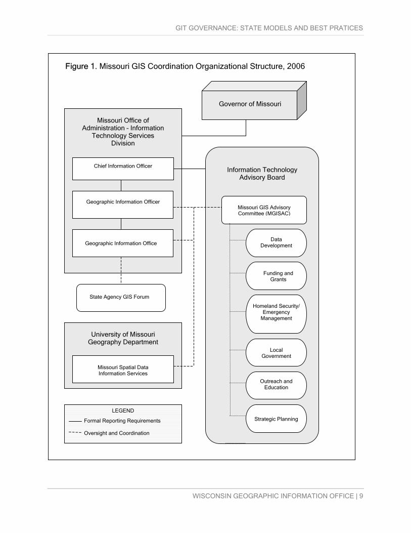
As of 2006, MGISAC is the lead GIS coordination body in Missouri and is housed within the
Department of Administration’s Office of Information Technology Services Division (ITSD),
which coordinates the data processing policies for the executive branch. MGISAC reports to the
CIO and provides an annual report to the Information Technology Advisory Board (ITAB), which
WISCONSIN GEOGRAPHIC INFORMATION OFFICE | 1
1 Warnecke, L., 2002. State Geographic Information and Related Technology (GI/GIT) Profile: Missouri. MGISAC Website, http://www.mgisac.org/Archives/GISProfile2002
GIT GOVERNANCE: STATE MODELS AND BEST PRATICES
has approval power over MGISAC charter and by-laws. MGISAC’s activities are supported by
the Missouri Spatial Data Information Service, and by the newly created Missouri Geographic
Information Office (GIO). The GIO is also housed within the ITSD and reports to the CIO (see
Figure 4). The Geographic Information Officer, who functions as the GIS coordinator for state
agencies and for the State of Missouri, was appointed by the CIO in 2005.2 Neither MGISAC nor
the GIO is authorized by statute or executive order.
Geographic Information Officer
First appointed by the CIO in 2005, the Geographic Information Officer (GIO) serves as the
statewide GIS coordinator, and serves as the primary contact for all geospatial matters in the
State of Missouri. The CIO’s appointment letter tasks the GIO “with providing statewide
coordination of [geographic information technology] activities,” including “data development
activities, potential funding distribution, federal initiatives, partnership opportunities and
appropriate standards.”3 The GIO also approves, adopts, and implements MGISAC initiatives.
The GIO directs the Missouri Geographic Information Office, located within the Office of
Administration, Information Technology Services Division. The GIO is not authorized by statute
or executive order, and as of 2006, is a voluntary part-time position.
Missouri Geographic Information Office
The mission of the Missouri Geographic Information Office4 is “to coordinate and support
geospatial technologies for the State of Missouri so it can efficiently serve the public’s spatial
data needs.” This office also provides administrative support for MSGISAC and the State
Agency GIS Forum. The Missouri Geographic Information Office is housed within the Office of
Administration, Information Technology Services Division. The Geographic Information Office
has one half-time staff member, the state GIO.
2 State GIO Appointment Letter from State CIO, Missouri GIO Website: http://www.gis.mo.gov/pdf/gio_letter.pdf
3 State GIO Appointment Letter from State CIO, Missouri GIO Website: http://www.gis.mo.gov/pdf/gio_letter.pdf
WISCONSIN GEOGRAPHIC INFORMATION OFFICE | 2
4 Missouri Geographic Information Office Website: http://www.gis.mo.gov/

GIT GOVERNANCE: STATE MODELS AND BEST PRATICES
Missouri Geographic Information Systems Advisory Committee
Formed as part of the 1995 Governor’s Initiative, the Missouri GIS Advisory Committee
(MGISAC)5 serves as the primary GIS coordination body for the State of Missouri. MGISAC is
housed within the Office of Administration, Information Technology Services Division, and
reports to the CIO and Information Technology Advisory Board (ITAB). The Chair of MGISAC
serves as an ex-officio member of the ITAB. The ITAB, in turn, advises the State CIO on IT
architecture, policy and standards.6 The Missouri Spatial Data Information Service (MSDIS) and
newly created GIO provide administrative and technical support.
MGISAC is not authorized under executive order or legislative action, but it does follow a set of
formal by-laws, which are revised periodically. As described in the 2006 By-laws (see
Appendix), the purpose of the MGISAC is to:
•
•
•
•
•
•
•
•
“[f]oster cooperation among state, local, and federal agencies, educational
institutions, private industry, and others in the field of Geographic Information
Systems (GIS);
[p]rovide guidance for the Missouri Spatial Data Information Service (MSDIS)
in fulfilling the objectives of the Missouri GIS Strategic Management Plan
(SMP);
[d]evelop GIS standards for the state;
[p]rovide an arena for discussions of relevant GIS issues;
[p]rovide expert advice to the Chief Information Officer (CIO) and the GIS
community on GIS related issues;
[f]acilitate resolution of GIS issues impacting the state;
[c]oordinate and facilitate statewide training as needed; and
[w]ork together with other states on standards and other GIS issues.” 7
5 Missouri GIS Advisory Committee Website: http://www.mgisac.org/
6 ITAB Charter, Missouri DOA ITSD Website: http://www.oa.mo.gov/itsd/cio/itab/itabcharter.pdf
WISCONSIN GEOGRAPHIC INFORMATION OFFICE | 3
7 MGISAC By-Laws, Amended August 10, 2006, MGISAC Website: http://www.mgisac.org/ByLaws/ByLaws and MGISAC Brochure, MGISAC Website, http://www.mgisac.org/uploads/Main/mgisac_brochure.pdf

GIT GOVERNANCE: STATE MODELS AND BEST PRATICES
Further, the objectives of MGISAC are to:
•
•
•
•
•
•
•
•
•
•
•
•
[m]eet with the CIO and/or the Information Technology Advisory Board (ITAB)
as needed to facilitate communication and cooperation between the MGISAC
and the Missouri Office of Administration—Information Technology Services
Division (ITSD);
[c]onduct monthly meetings;
[r]eview MSDIS operational status reports quarterly;
[r]eview MSDIS financial statements quarterly;
[s]end at least one representative to regional and national GIS conferences;
as needed;
[p]lan and conduct the Missouri GIS Conference biennially; and
[a]ssist in planning and conducting the MAGIC Conference biennially. Originally, MGISAC focused largely on state agency GIS coordination, and was comprised of
nine (9) members, including representatives from five (5) state agencies, two (2) federal
agencies, one (1) local government, and one (1) university. As GIS implementation grew in
Missouri, however, so did the Committee. In 1999, the Committee’s by-laws were revised to
allow for additional committee members. By 2001, GISAC was comprised of twenty-one (21)
members, including representatives from:
Ten (10) state agencies;
Two (2) federal agencies;
Six (6) local governments;
Two (2) universities; and,
One (1) private company.
But, only representatives from state agencies were voting members; this lack of voting power
diminished the enthusiasm of non-state members to fully participate in MGISAC meetings and
activities. During this transition period, some state agency offices advocated that only state
agency members should be allowed to vote on issues exclusively of state interest.
WISCONSIN GEOGRAPHIC INFORMATION OFFICE | 4
GIT GOVERNANCE: STATE MODELS AND BEST PRATICES
In 2006, MGISAC’s membership was restructured again to broaden representation, and to allow
for non-state representatives to serve as voting members. Under the revised 2006 by-laws,8
there are three types of members: ex-officio, “state,” and “cooperating.” The two ex-officio, non-
voting members include the GIO from the Missouri Office of Administration—Information
Technology Services Division (ITSD), and a representative of the Missouri Spatial Data
Information Service (MSDIS). “State” members include representatives from “any of the three
branches of state government or statewide elected officials that provide oversight and
management of an operational GIS environment in the State of Missouri.” "Cooperating"
members, on the other hand, are selected from the following sectors: federal government
agencies; local government agencies; universities, colleges, or other academic institutions;
public utility organizations; and not-for-profit organizations, cooperative government agencies,
and quasi-government agencies.
In 2007, the Committee is comprised of twenty-nine (29) members, including:
•
•
•
Two ex-officio members;
Eleven (11) state agencies, including one (1) member from the Missouri
House of Representatives; and,
Sixteen (16) cooperating agencies and organizations, which, as of the writing
of this report, included:
Two (2) federal agencies;
Tour (4) municipal governments;
Three (3) county governments;
One (1) village government;
One (1) professional mapping organization;
One (1) regional coordinating organization;
One (1) military department;
One (1) not-for-profit; and,
One (1) council of governments.
WISCONSIN GEOGRAPHIC INFORMATION OFFICE | 5
8 2006 By-Laws, Amended August 10, 2006, MGISAC Website: http://www.mgisac.org/ByLaws/ByLaws

GIT GOVERNANCE: STATE MODELS AND BEST PRATICES
Both state members and cooperating members have voting privileges. Individuals from the
private sector cannot serve as voting members representing their companies, but can serve if
they are representing a professional GIS organization or not-for-profit.
The Chief Information Officer (CIO) of the Missouri Office of Administration Information
Technology Services Division (ITSD) appoints all members of MGISAC; and, except for “ex-
officio” members, all “state” and “cooperating” members are appointed from candidates
nominated through MGISAC or the CIO. Terms were increased to two years from one-year
appointments, which members may serve consecutively. A Chair and Vice-Chair of MGISAC
are elected from the state members by a majority vote, and the Secretary is elected from the full
membership. MGISAC meets monthly, although members are not compensated for their
participation.
MGISAC currently has six (6) subcommittees, including Data Development, Funding and
Grants, Homeland Security/Emergency Management, Local Government, Outreach and
Education, and Strategic Planning, as well as associated working groups or teams. The
objectives of the Local Government Committee, for example, are: 1) to improve web content for
local government GIS users; 2) to develop relationships with related organizations; 3) to serve
as the MGISAC liaison to local governments; 4) to develop and distribute memorandum of
agreement templates; and 5) to host regional meetings. Anyone can participate as members of
MGISAC’s subcommittees.
State Agency GIS Forum
Established by the GIO in February 2006, the State Agency GIS (SAG) Forum serves as a
forum for state agency GIS coordinators to discuss and strategically address geospatial issues
related to state government.9 The Forum meets at least monthly and when needed.
WISCONSIN GEOGRAPHIC INFORMATION OFFICE | 6
9 State Agency GIS Forum, GIO Website: http://www.gis.mo.gov/SAG_Forum.htm

GIT GOVERNANCE: STATE MODELS AND BEST PRATICES
Missouri Spatial Data Information Service
Established within the University of Missouri's Geographic Resources Center (GRC) in 1995,
the Missouri Spatial Data Information Service (MSDIS)10 was tasked with the creation of a
geospatial data clearinghouse and with the provision of geographic information services and
support to state agencies. Today, MSDIS is responsible “for data storage and access,
standardization of both digital and tabular data, creation of the data dictionary, compilation of
metadata, and statewide GIS user information networks.”11 As stated, the goal of the MSDIS is
“to encourage use of GIS technology and geographic data resources in state government by
providing practical support in the form of GIS-related services to current and potential user
agencies.” To this end, MSDIS will:
•
•
•
•
“establish and make available to the GIS community in state and local
government a core database of geographic information to be held and
maintained in common as a continuing asset within an archive mechanism;
encourage development, maintenance, and dissemination of thematic
databases built on the core database foundation;
encourage use of GIS technology and geographic data resources in state
government by providing practical support in the form of GIS-related services
to current and potential user agencies, and
inform supervisors, managers, and other professionals in user agencies and
state government at large about GIS technology, and its potential and
capabilities in state government.” 12 The Missouri Geographic Information Systems Advisory Committee and the Chief Information
Officer assists MSDIS with the formulation of work plans and provides direction for MSDIS
activities. MSDIS, in turn, provides administrative and technical support to the MGISAC and
10 Missouri Spatial Data Information Service Website: http://msdisweb.missouri.edu/
11 MSDIS Website, About MSDIS: http://msdisweb.missouri.edu/about.htm
12 MSDIS Website, Goals: http://msdisweb.missouri.edu/goals.htm
WISCONSIN GEOGRAPHIC INFORMATION OFFICE | 7

GIT GOVERNANCE: STATE MODELS AND BEST PRATICES
provides geographic information access and distribution services for the state. The MSDIS has
2.5 FTE staff dedicated to serve in this role.
Missouri Resource Assessment Partnership
The University of Missouri’s Missouri Resource Assessment Partnership (MoRAP)13 is an
interagency partnership involving state and federal agencies, not-for-profits organizations, and
universities with the purpose of providing expertise in GIS, remote sensing, and natural
resource management. MoRAP activities are directed by a steering committee and supported
by a technical committee.
WISCONSIN GEOGRAPHIC INFORMATION OFFICE | 8
13 MoRAP Website: http://www.cerc.usgs.gov/morap/
GIT GOVERNANCE: STATE MODELS AND BEST PRATICES
LEGEND Formal Reporting Requirements Oversight and Coordination
Missouri Spatial Data Information Services
State Agency GIS Forum
Information Technology Advisory Board
Strategic Planning
Outreach and Education
Local Government
Homeland Security/ Emergency
Management
Funding and Grants
Data Development
Missouri GIS Advisory Committee (MGISAC)
University of Missouri Geography Department
Geographic Information Office
Geographic Information Officer
Chief Information Officer
Missouri Office of Administration – Information
Technology Services Division
Figure 1. Missouri GIS Coordination Organizational Structure, 2006
Governor of Missouri
WISCONSIN GEOGRAPHIC INFORMATION OFFICE | 9

GIT GOVERNANCE: STATE MODELS AND BEST PRATICES
FUNDING AND SUPPORT
Interview respondents in Missouri felt that funding for GIS coordination and development has
not been adequate; in particular, funding is needed for large-scale data development projects
such as street centerlines and high-resolution elevation data. But, this may change with the
implementation of a new Geographic Information Office (GIO) and the appointment of a
Geographic Information Officer.
The Geographic Information Office is funded by general revenue through the Office of
Administration, Information Technology Services Division, which covers administrative costs
and coordination activities. The Geographic Information Office has one part-time staff member –
the State Geographic Information Officer. The Missouri Spatial Data Information Service
(MSDIS) is supported in part through general revenue, which is supplemented with income
generated from project grants, as well as in kind contributions and student participation.
The Missouri Geographic Information Systems Advisory Committee (MGISAC) has no
dedicated funding. Member expenses are covered by participating agencies. The cost of
providing administrative and technical support to MGISAC is minimal and is covered by the GIO
and MSDIS. Some proceeds were generated from the last annual state conference, and have
been used to provide statewide workshops. Geospatial data related to MGISAC initiatives is
developed through individual project-based state and federal-agency partnerships.
CHALLENGES AND OPPORTUNITIES
Without authorization by executive order or legislation, the Missouri Geographic Information
Systems Advisory Committee (MGISAC) does not carry the same weight as other state boards
that have this authority. Furthermore, MGISAC membership has moved away from being
comprised of agency directors or their designees, who have the power to decide policy and set
budgets, to being comprised of largely mid-level GIS managers. An incentive is needed to
renew and encourage policy maker participation. On the other hand, current members bring to
the table a high level of technical sophistication and valuable institutional knowledge. MGISAC
is comprised of a large number of dedicated and highly-motivated members, with little member
WISCONSIN GEOGRAPHIC INFORMATION OFFICE | 10

GIT GOVERNANCE: STATE MODELS AND BEST PRATICES
turnover. Furthermore, while local government and other organizations have been
underrepresented on MGISAC in the past, the new membership structure now allows for
participation from a broad spectrum of GIS data users and producers.
Of note, MGISAC and MSDIS completed the Missouri/FGDC Cooperative Agreement Program
’04 in which fifty-three (53) local government personnel participated in a three-day GIS course to
encourage the provision of local data for The National Map. As part of this effort, all sixteen (16)
regional councils of government formally agreed to share geospatial data. In 2005, the state
received additional funding to provide training and support for local governments to collect and
maintain their Structures data layers.
Currently, MGISAC is guiding the development and enhancement of geospatial technologies
within the State Information Technology Infrastructure in support of the Missouri Adaptive
Enterprise Architecture (MAEA) Plan. MGISAC is also coordinating with the Information
Technology Services Division, the Office of Homeland Security, and MSDIS on the development
of the communication infrastructure necessary to support Homeland Security efforts, including
the development of the databases and geospatial layers necessary to support homeland
security planning, mitigation, risk assessment, and other operations.14 Lastly, MGISAC has
initiated a Flood Plain Modernization Project, in collaboration with two universities, USGS, State
Emergency Management, and FEMA, and has released a request for information for a
Statewide Orthophotography Project.
WISCONSIN GEOGRAPHIC INFORMATION OFFICE | 11
14 2005 NSGIC State Summaries, Missouri, p. 49, www.nsgic.org, accessed September 2006.

GIT GOVERNANCE: STATE MODELS AND BEST PRATICES
Appendices
A. MGISAC BY-LAWS, AMENDED FEBRUARY 9, 2006
MGISAC By-Laws, MGISAC Website: http://www.mgisac.org/ByLaws/ByLaws
Current By-Laws (amended February 9, 2006)
1. Name The name of the organization shall be the Missouri Geographic Information Systems Advisory
Committee (MGISAC).
2. Purpose In accordance with the Governor’s Initiative commenced in April 1995, the purpose of the
MGISAC is to:
2.1 Foster cooperation among state, local, and federal agencies, educational institutions, private
industry, and others in the field of Geographic Information Systems (GIS);
2.2 Provide guidance for the Missouri Spatial Data Information Service (MSDIS) in fulfilling the
objectives of the Missouri GIS Strategic Management Plan (SMP);
2.3 Develop GIS standards for the state;
2.4 Provide an arena for discussions of relevant GIS issues;
WISCONSIN GEOGRAPHIC INFORMATION OFFICE | 12

GIT GOVERNANCE: STATE MODELS AND BEST PRATICES
2.5 Provide expert advice to the Chief Information Officer (CIO) and the GIS community on GIS
related issues;
2.6 Facilitate resolution of GIS issues impacting the state;
2.7 Coordinate and facilitate statewide training as needed; and
2.8 Work together with other states on standards and other GIS issues.
3. Objectives
The objectives of the MGISAC are to:
3.1 Meet with the CIO and/or the Information Technology Advisory Board (ITAB) as needed to
facilitate communication and cooperation between the MGISAC and the Missouri Office of
Administration—Information Technology Services Division (ITSD);
3.2 Conduct monthly meetings;
3.3 Review MSDIS operational status reports quarterly;
3.4 Review MSDIS financial statements quarterly;
3.5 Send at least one representative to regional and national GIS conferences; as needed;
3.6 Plan and conduct the Missouri GIS Conference annually; and
3.7 Assist in planning and conducting the MAGIC Conference biennially.
4. Membership 4.1 Member Composition
WISCONSIN GEOGRAPHIC INFORMATION OFFICE | 13

GIT GOVERNANCE: STATE MODELS AND BEST PRATICES
Membership on the MGISAC shall be classified in one of three ways: "ex-officio" members,
"state" members or "cooperating" members.
4.1.1 "Ex-officio" Members There will be two ex-officio members on the MGISAC. One will be the GIO from the Missouri
Office of Administration—Information Technology Services Division (ITSD), and one will be from
the Missouri Spatial Data Information Service (MSDIS). Ex-officio members shall not have
voting privileges.
4.1.2 "State" Members The representatives of any of the three branches of state government or statewide elected
officials that provide oversight and management of an operational GIS environment in the State
of Missouri are eligible for MGISAC membership as a "State" member. "State" members will
have voting privileges.
4.1.3 "Cooperating" Members "Cooperating" members shall be selected from the following sectors and assigned to the
appropriate caucus:
• federal government agencies;
• local government agencies;
• universities, colleges, or other academic institutions;
• public utility organizations; and
• not-for-profit organizations, cooperative government agencies, and quasi-government
agencies.
"Cooperating" members will have voting privileges and will be limited to one member per
agency or organization.
Agency means any administrative body existing under the constitution or by law and authorized
by law or the constitution to make rules or to adjudicate contested cases. Local governments
shall be defined as county, city, town or village governing bodies.
WISCONSIN GEOGRAPHIC INFORMATION OFFICE | 14

GIT GOVERNANCE: STATE MODELS AND BEST PRATICES
4.2 Members All members of the MGISAC shall be appointed by the Chief Information Officer (CIO) of the
Missouri Office of Administration—Information Technology Services Division (ITSD). Except for
"ex-officio" members, all "state" and "cooperating" members shall be appointed from candidates
nominated through the MGISAC or the CIO. Existing members in good standing may be re-
nominated during the month of April. The CIO will evaluate the nominations and make
appointments no later than two months after receiving the nominations.
4.3 Term Appointed members of the MGISAC shall serve a term of no more than two years. Members
may serve consecutive terms. The term shall be July 1 to June 30. Vacancies occurring before
the expiration of the term shall be filled by appointment from a list of nominees submitted by the
MGISAC to the CIO. These members shall serve the remaining portion of the retiring member’s
term.
5. Structure 5.1 Advisory Committee The full membership of the Missouri GIS Advisory Committee will meet and act to provide
leadership and direction for the state in the development, management, and use of geographic
information.
5.2 Officers Nominations for MGISAC officers shall be solicited and initiated during the regularly scheduled
July meeting and can be submitted through the end of that month. Nominees shall be given an
opportunity to provide the Committee with a platform statement before the officer elections are
held. Officers shall serve one-year terms beginning at the conclusion of the meeting at which
they are elected.
5.2.1 The Chair shall be elected from "state" membership by a majority vote.
WISCONSIN GEOGRAPHIC INFORMATION OFFICE | 15

GIT GOVERNANCE: STATE MODELS AND BEST PRATICES
5.2.2 The Vice-chair shall be elected from "state" membership by a majority vote. The Vice-chair
normally assumes the duties of the Chair in the absence of the Chair. If the Vice-chair cannot
fulfill the duties of the Chair, then a Chair shall be elected to fill the vacancy in the same manner
as other officers. If the Vice-chair steps down during his or her term, then a Vice-chair shall be
elected to serve the remainder of the term.
5.2.3 The Secretary shall be elected from the full membership of the MGISAC by a majority
vote. If the Secretary steps down during his or her term, then a Secretary shall be elected to
serve the remainder of the term.
5.3 Subcommittees Subcommittees are established to facilitate MGISAC business and exist at the discretion of the
Chair. The Chair designates the structure and leadership of subcommittees in consultation with
the other officers.
6. Duties and Responsibilities 6.1 Members Members of MGISAC are expected to attend and participate in the MGISAC meetings as
committee members or committee officers. If a member is unable to attend a particular meeting,
a proxy should attend in the member’s place. If three consecutive regularly scheduled meetings
are missed by a member without notifying the Committee Chair or the Secretary before the
meeting begins, and no proxy from the member’s organization attends, the member shall be
deemed to have resigned from the committee.
6.2 Chair The Chair is responsible for leadership and coordination of all MGISAC activities. In addition,
the Chair is responsible for meeting schedules, agendas, signing all correspondence, and
presiding at meetings.
WISCONSIN GEOGRAPHIC INFORMATION OFFICE | 16

GIT GOVERNANCE: STATE MODELS AND BEST PRATICES
6.3 Vice-chair The Vice-chair is responsible for assisting the Chair and assuming the duties of the Chair
temporarily when the Chair is unavailable for any reason.
6.4 Secretary The Secretary is responsible for recording the minutes of the meetings and making them
available for posting on the MGISAC web site. The Secretary shall transmit officer election
results to the CIO.
6.5 Subcommittee Chairs A Subcommittee Chair is responsible for the leadership of a specified committee. A
Subcommittee Chair is responsible for conducting meetings and any activities necessary for the
successful completion of the Subcommittee’s tasks.
7. Voting and Elections 7.1 Voting Each state and cooperating member is allowed one vote. Votes shall only be cast during
meetings where more than 50% of all voting members or their designated proxies are present.
7.2 Elections Officer elections are to be conducted during the regularly scheduled August meeting. Written
ballots are to be distributed to voting members or their proxies, and are to be collected and
counted by at least two members of the nomination subcommittee. Members who are unable to
attend or to send a proxy to the meeting during which elections are held may request and
submit ballots prior to the start of the meeting. Election winners will be announced once the
votes are tallied. The number of votes cast for each candidate will be made available to
members by the Secretary upon request after the conclusion of the meeting during which
elections are conducted.
WISCONSIN GEOGRAPHIC INFORMATION OFFICE | 17

GIT GOVERNANCE: STATE MODELS AND BEST PRATICES
WISCONSIN GEOGRAPHIC INFORMATION OFFICE | 18
8. Meetings MGISAC meetings are normally held on a monthly basis at the discretion of the MGISAC Chair
in consultation with the membership.
9. Amendments Amendments to these bylaws shall be offered by submission in writing to all MGISAC members
at least ten days before the next scheduled meeting. The proposed amendment shall be taken
up for consideration at the next scheduled meeting of the Committee where more than 50% of
all voting members or their designated proxies are present. The amendment shall be adopted
when it has been approved by at least a 75% majority of those casting votes at the meeting of
the MGISAC where the amendment is considered.