modelling marine recreation potential in england: annex 1 · – step by step instructions on ......
TRANSCRIPT

Modelling Marine Recreation Potential in England Annex Volume 1: Annex A to D (Non-technical Annex) MMO Project No: MMO1064
Project funded by: Marine Management Organisation
Report prepared by: Marine Planning Consultants


© Marine Management Organisation 2014 This publication (excluding the logos) may be re-used free of charge in any format or medium (under the terms of the Open Government Licence www.nationalarchives.gov.uk/doc/open-government-licence/). It may only be re-used accurately and not in a misleading context. The material must be acknowledged as Marine Management Organisation Copyright and use of it must give the title of the source publication. Where third party Copyright material has been identified, further use of that material requires permission from the Copyright holders concerned. Disclaimer This report contributes to the Marine Management Organisation (MMO) evidence base which is a resource developed through a large range of research activity and methods carried out by both the MMO and external experts. The opinions expressed in this report do not necessarily reflect the views of the MMO nor are they intended to indicate how the MMO will act on a given set of facts or signify any preference for one research activity or method over another. The MMO is not liable for the accuracy or completeness of the information contained nor is it responsible for any use of the content. This report should be cited as MMO (2014). Modelling Marine Recreation Potential in England – Annex A to D. A report produced for the Marine Management Organisation, pp 37. MMO Project No: 1064. ISBN: 978-1-909452-27-5. First published June 2014.

Contents
Project Resources External to the Main Report .................................................... 1 Annexes ................................................................................................................. 1 Annex Volume 1 ..................................................................................................... 1 Annex Volume 2 ..................................................................................................... 1 Electronic Deliverables ........................................................................................... 2
Annex A: Project References & Deliverables ............................................................ 3
A1. Acronyms ......................................................................................................... 3 A2. Terminology ..................................................................................................... 4 A3. References ...................................................................................................... 6
Annex B: Modelled Activity Maps .............................................................................. 8 Annex C: Activity Preferences ................................................................................. 21
C1. Activities ........................................................................................................ 21 C2. Influencing Parameters .................................................................................. 21
Annex D: Activity Consultation ................................................................................ 25
D1. Consultees .................................................................................................... 25 D2. Consultation Stages ...................................................................................... 27 D3. Activity Matrix ................................................................................................ 27 D4. Pilot study and Webinar series ...................................................................... 28 D5. Workshop ...................................................................................................... 29 D6. Stakeholder Engagement Feedback ............................................................. 30 D7. Post Workshop Alterations ............................................................................ 32

Figures Figure 1: Watching land and sea wildlife from land map. ........................................... 9 Figure 2: Beach activities map including swimming. ................................................ 10 Figure 3: Paddle sports activity map. ....................................................................... 11 Figure 4: Surfing activity map. .................................................................................. 12 Figure 5: Windsurfing activity map. .......................................................................... 13 Figure 6: Sailing activity map. .................................................................................. 14 Figure 7: Motorboating activity map. ........................................................................ 15 Figure 8: Personal watercraft activity map. .............................................................. 16 Figure 9: Scuba diving activity map. ......................................................................... 17 Figure 10: Boat based wildlife watching activity map. .............................................. 18 Figure 11: Boat based angling activity map. ............................................................. 19 Figure 12: Shore based angling activity map. .......................................................... 20 Tables Table 1. Activities not taken forward in model .......................................................... 21 Table 2. Parameters that Inform the Model .............................................................. 21 Table 3: Stakeholder project participation. ............................................................... 26


Modelling marine recreation potential in England – Annex A to D
Project Resources External to the Main Report
Annexes
The project annexes consist of two volumes. The first volume comprises the non-technical annexes, including a map annex, activity preferences and stakeholder consultation. The second volume comprises the technical annexes, including detail on input data and data layer processing, model development, confidence assessment and Marine Recreation Model User Guide. These annex volumes are separate documents and are referenced in the main report. Only the Vol. 2 Technical Annex is stand alone and can be used separately from the main project report to inform the model development. The annexes are structured as follows:
Annex Volume 1
Annex A: Guide & References - provides a reference list of acronyms and terminology descriptions, as well as references cited throughout the project report and appendices.
Annex B: Modelled Activity Maps - provides maps of the activities modelled in this study, presented at the national scale.
Annex C: Activity Preferences - provides further detail on the activities selected to model and the influencing user preferences, or parameters. This includes the approach taken to prioritising the parameters and a more detailed breakdown of the varying elements of the Activity Matrix (activity preferences).
Annex D: Activity Consultation - gives further description to the stakeholder consultation steps taken and stakeholder feedback.
Annex Volume 2
Annex E: Model Baseline & Definition - technical annex detailing the baseline model and its definitions.
Annex F: Input Data Processing - technical annex detailing the input data processing, including the input data catalogue.
Annex G: Common/Multi-Layer Processing – technical annex providing a description of the Tool 1 Gridding Tools and their use
Annex H: Model Methodology - is a technical annex describing the model methodology, detailing Tool 2, the ‘Union Tool’, Tool 3, the model ready Activity Matrix and Tool 4, the model.
Annex I: Confidence Assessment - provides an assessment of the model outputs, including the confidence assessment of the input data (not sourced from the MMO) and the confidence assessment of the input data layers.
1 of 32
Modelling marine recreation potential in England – Annex A to D
2 of 32
Annex J: Future application of the model – provides recommendations for future use and evolution of the model
Annex K: MMO1064 Marine Recreation Model User Guide – step by step instructions on processing data suitable for the model and rerunning the model.
Electronic Deliverables
Below is a complete list of electronic deliverables with this project.
• Final report • Vol. 1 Report Annex • Vol. 2 Technical Annex, including model guidance • Project research flier • Data processing logs, including flow diagrams • GIS data layers • XML metadata • Model Tools 1, 2, 3 and 4 • Combined Consultation Activity Matrix spreadsheet • Data confidence assessments • Input data catalogue.
All associated documents for the MMO1064 project can be found in the MMO website evidence pages at: http://www.marinemanagement.org.uk/evidence/1064.htm

Modelling marine recreation potential in England – Annex A to D
Annex A: Project References and Deliverables
A1. Acronyms
Acronym Description .mxd File extension: ESRI ArcGIS map document
AONB Area of Outstanding Natural Beauty
BKSA British Kite Sports Association
BMF British Marine Federation
BSAC British Sub-Aqua Club
BWSW British Water Ski and Wakeboard
Cefas Centre for Environment, Fisheries and Aquaculture Science
Defra Department for Environment, Food and Rural Affairs
EA Environment Agency
EMS European Marine Sites
GI Geographic Information
GIS Geographic Information System
IFCA Inshore Fisheries Conservation Authority
INCA Industry Nature Conservation Association
JNCC Joint Nature Conservation Committee
MCA Maritime and Coastguard Agency
MCS Marine Conservation Society
MCZ Marine Conservation Zone
MEDIN Marine Environmental Data & Information Network
MMO Marine Management Organisation
MPC Marine Planning Consultants
NE Natural England
NT National Trust
PDF Portable Document Format
QA Quality Assurance
RNLI Royal National Lifeboat Institution
RSPB Royal Society for the Protection of Birds
RYA Royal Yachting Association
SAC Sub-Aqua Club
3 of 32

Modelling marine recreation potential in England – Annex A to D
Acronym Description SCUBA Self-contained Underwater Breathing Apparatus
SLSGB Surf Life Saving Great Britain
A2. Terminology
Term Description
ArcGIS A commonly used mapping software provided by ESRI.
Attribute data Information describing or relating to a location, event or entity, for example habitat type.
Common aims agreement
Document outlining agreement between MMO and third party to work together to achieve mutual targets.
Confidence assessment
A measure of confidence in a dataset, assessing numerous criteria including data capture methodology and level of peer-review.
Data licence agreement
Agreement between two parties outlining terms for one to supply data to the other
Dataset A collection of related data depicting an event, or series of events. Held in either tabular or spatial form.
Discovery portal A MEDIN search facility, enabling geographic search tools to find MEDIN-compliant datasets.
European Marine Sites (EMS)
This term refers to special areas of conservation (SACs) and special protection areas (SPAs), which are protected under the EC Habitats Directive and Birds Directive.
Geographic Information System (GIS)
Software that facilitates the storage, management, analysis and production of spatial data.
Marine Environmental Data and Information Network (MEDIN)
MEDIN promotes the sharing of, and access to, marine data, through data repositories, search facilities and a number of data guidelines and a metadata standard.
Marine Plan Areas Areas in England’s marine area designated for marine planning, including both Inshore and Offshore Marine Plan Areas.
Marine recreation activity
Recreational activities that occur on, or in association with the marine environment.
4 of 32

Modelling marine recreation potential in England – Annex A to D
5 of 32
Metadata Information about data, such as when a piece of data was collected, by whom and using what method(s).
MMO1013 Code assigned to the first recreation report commissioned by the MMO on marine recreation evidence which looked to gather datasets at a national scale and also to inform the East Coast Marine Plan Areas.
MMO1043 Code assigned to the second recreation report commissioned by the MMO on marine recreation evidence which looked to gather further datasets at a national scale, to inform the South Coast Marine Plan Areas and develop tools to inform future data gathering.
MMO1064 Code assigned to this report.
Quality Assurance A series of steps taken to ensure a product – in this case a dataset – is fit for purpose.
Shapefile Proprietary GIS data format, created by ESRI (the manufacturers of ArcGIS).
Spatial data Data with a geographic ‘tag’, meaning it has a location in space that can be plotted and used to inform decision-making.
StakMap Data product released by Natural England, based on a survey of marine recreation activities in England.
Web GIS An online GIS platform that displays GIS data to a wide audience

Modelling marine recreation potential in England – Annex A to D
A3. References
Balaguer, P., Diedrich, A., Sarda, R., Fuster, M., Canellas, B., & Tintore, J., 2011. Spatial analysis of recreational boating as a first step for marine spatial planning in Mallorca (Balearic Islands, Spain). Ocean & Coastal Management [online] 54, pp. 241-249 Buckecker, M., Degenhardt, B & Kienast, F., 2013. Developing a spatial explicit model of people's nearby outdoor recreation use. [online] TObeWELL Conference, 3-6 September 2013. Available from: http://www.tobewell.eu/media/universityofexeter/businessschool/documents/research/tobewell/wageningen/1B_Buchecker.pdf [Accessed February 2014] Chambers, C., Haines, R., Jones, D., Pitts, J., McAleese, L, Wellard, K., 2013. Wales Activity Mapping: A Pilot Study on the Economic Valuation of Marine Recreation Activity in Pembrokeshire. Marine Planning Consultants, in consortium with Atkins and Pembrokeshire Coastal Forum. Funded by Port of Milford Haven and the Sustainable Development Fund (SDF), a Welsh Government initiative. HM Government, 2011. UK Marine Policy Statement [pdf] Defra. Available at: https://www.gov.uk/government/uploads/system/uploads/attachment_data/file/69322/pb3654-marine-policy-statement-110316.pdf [Accessed 12 March 2014] Marine and Coastal Access Act 2009 (c.23) London: HMSO Marine Management Organisation (MMO), 2013a. Strategic Scoping Report August 2013 [pdf] MMO. Available at: http://www.marinemanagement.org.uk/marineplanning/key/documents/ssr-august2013.pdf [Accessed 12 March 2014] Marine Management Organisation (MMO), 2013b. Compilation of spatial data on marine activities: Phase 2. A report produced for the Marine Management Organisation, pp 83. MMO Project No: 1043. ISBN: 978-1-909452-10-7. Marine Management Organisation (MMO), 2012a. Compilation of spatial data on marine recreational activities. A report produced for the Marine Management Organisation, pp 94. MMO Project No: 1013. ISBN: 978-1-909452-00-8. Marine Management Organisation (MMO), 2012b. Evidence and Issues Report for the East Inshore and East Offshore marine plan areas [online] MMO. Available at: http://www.marinemanagement.org.uk/marineplanning/areas/east_issues.htm [Accessed March 2014] Marine Management Organisation (MMO) and Marine Scotland, 2012c. A critical review of tools and methods to apply marine social and economic data to decision-making. A report produced for the Marine Management Organisation and Marine Scotland, pp 58. MMO Project No: 1012. ISBN: 978-1-909452-02-2. Marine Management Organisation (MMO) and Marine Scotland, 2012d. A review of marine social and economic data. A report produced for the Marine Management
6 of 32

Modelling marine recreation potential in England – Annex A to D
Organisation and Marine Scotland, pp 42. MMO Project No: 1012. ISBN: 978-1-909452-01-5. Natural England, 2013. Marine Conservation Zones [online]. Available at: http://www.naturalengland.org.uk/ourwork/marine/mpa/mcz/default.aspx [Accessed February, 2013] Armstrong, M.; Brown, A.; Hargreaves, J.; Hyder, K.; Pilgrim-Morrison, S.; Munday, M.; Proctor, S.; Roberts, A.; Williamson K., 2013. Sea Angling 2012 – a survey of recreational sea angling activity and economic value in England. [pdf] Defra. Available at: http://www.marinemanagement.org.uk/seaangling/documents/finalreport.pdf [Accessed in February 2014] Roger Tym & Partners, 2011. Maximising the socio-economic benefits of marine planning for Englsih coastal communities [pdf] MMO. Available at: http://www.marinemanagement.org.uk/marineplanning/key/documents/se_national.pdf [Accessed February 2014] Ruiz-Frau, A., Hinz, H., Edwards-Jones, G., Kaiser, M.J. 2013. Spatially explicit economic assessment of cultural ecosystem services: Non-extractive recreational uses of the coastal environment related to marine biodiversity. Marine Policy [online] 38, pp. 90-98 [Accessed 18 March 2014] St. Martin, K. & Hall-Arberb, M. (2008) The missing layer: Geo-technologies, communities, and implications for marine spatial planning. Marine Policy. 32:5, pp 779-786. Tappin, D.R.; Pearce, B.; Fitch, S.; Dove, D.; Gearey, B.; Hill, J.M.; Chambers, C.; Bates, R.; Pinnion, J.; Diaz Doce, D.; Green, M.; Gallyot, J.; Georgiou, L.; Brutto, D.; Marzialetti, S.; Hopla, E.; Ramsay, E.; Fielding, H.. (2011) The Humber Regional Environmental Characterisation. Marine Aggregate Levy Sustainability Fund, 345pp. (OR/10/054)
7 of 32

Modelling marine recreation potential in England – Annex A to D
8 of 32
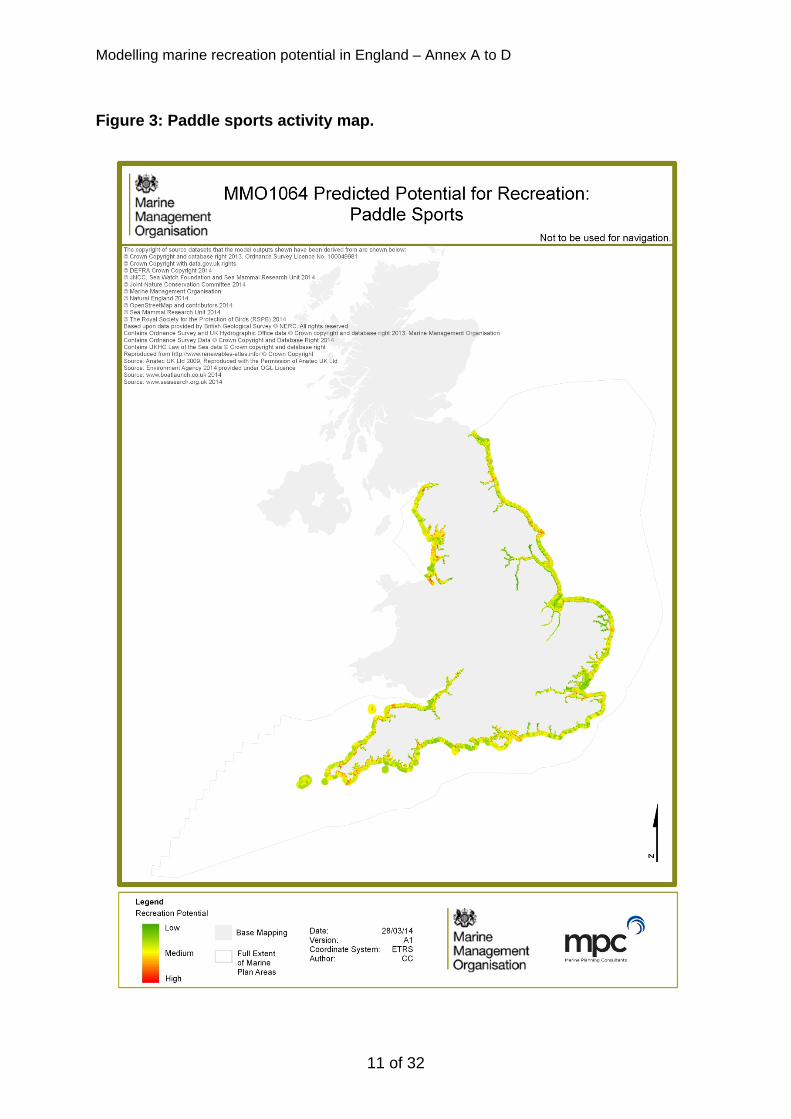
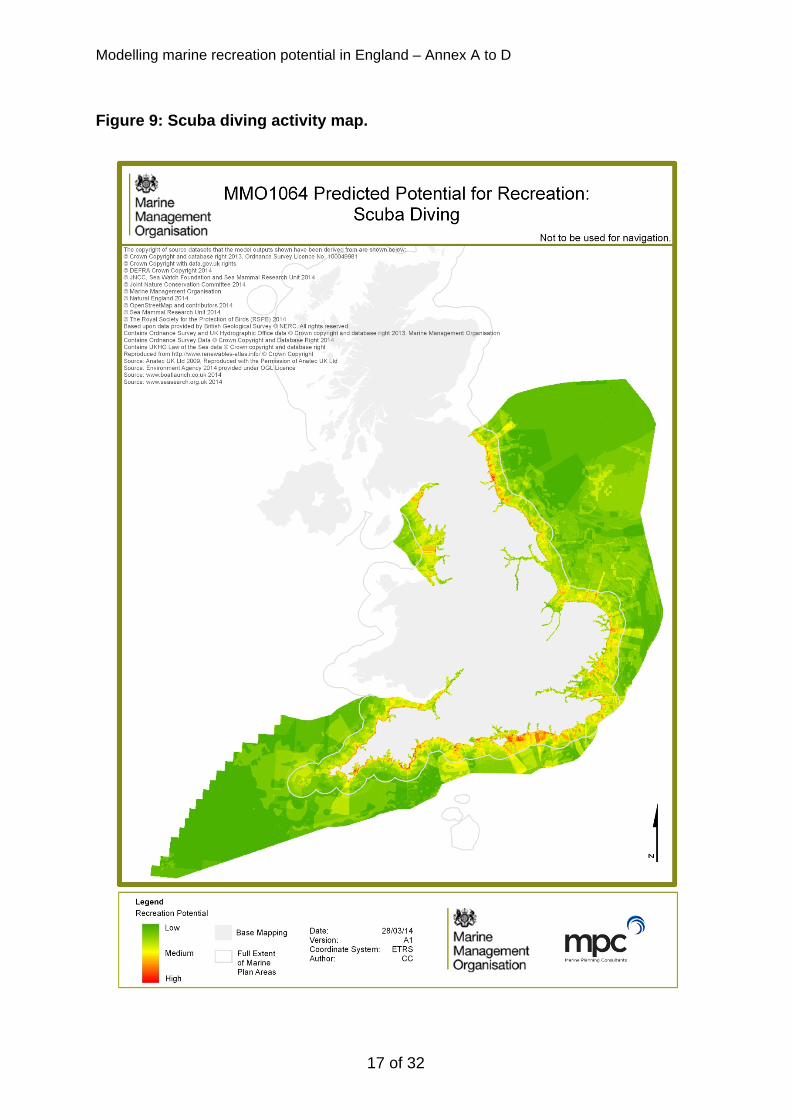
Annex B: Modelled Activity Maps The following maps illustrate the modelled outputs of the activities included in this study. The model and a series of interim activity output maps were validated by stakeholders at the project workshop on the 5th March. The maps in this annex are the result of further data and model development post workshop validation.

Modelling marine recreation potential in England – Annex A to D
Figure 1: Watching land and sea wildlife from land map.
9 of 32

Modelling marine recreation potential in England – Annex A to D
Figure 2: Beach activities map including swimming.
10 of 32
Modelling marine recreation potential in England – Annex A to D
Figure 3: Paddle sports activity map.
11 of 32

Modelling marine recreation potential in England – Annex A to D
Figure 4: Surfing activity map.
12 of 32

Modelling marine recreation potential in England – Annex A to D
Figure 5: Windsurfing activity map.
13 of 32

Modelling marine recreation potential in England – Annex A to D
Figure 6: Sailing activity map.
14 of 32

Modelling marine recreation potential in England – Annex A to D
Figure 7: Motorboating activity map.
15 of 32

Modelling marine recreation potential in England – Annex A to D
Figure 8: Personal watercraft activity map.
16 of 32
Modelling marine recreation potential in England – Annex A to D
Figure 9: Scuba diving activity map.
17 of 32

Modelling marine recreation potential in England – Annex A to D
Figure 10: Boat based wildlife watching activity map.
18 of 32

Modelling marine recreation potential in England – Annex A to D
Figure 11: Boat based angling activity map.
19 of 32

Modelling marine recreation potential in England – Annex A to D
Figure 12: Shore based angling activity map.
20 of 32

Modelling marine recreation potential in England – Annex A to D
Annex C: Activity Preferences
C1. Activities
Table 1: Activities not taken forward in model.
Activity Reason for Excluding from Model Coasteering Stakeholder not available
Beach volleyball Accommodated by beach activities - broadly - and available dataset on volleyball courts
Beach ultimate frisbee Minor activity/land based Power kiting Stakeholder not available Kite buggying Stakeholder not available Snorkelling Accommodated by swimming - broadly Kite surfing Accommodated by surfing and windsurfing Motor racing Accommodated by motor boating - broadly Bait collection Angling modelled in preference to bait collection Wildfowling Stakeholder not available
C2. Influencing Parameters
Table 2: Parameters that Inform the Model.
Parameter Group
Parameter Description Justification for use in model
1 Area Baseline Activity Area
The baseline area required by the activity in terms of inshore/offshore extent
Imperative parameter to all activities to inform suitability, also used to mask model outputs
2 Area Estuary The presence of estuaries
Estuaries can provide poor conditions, e.g. water quality/turbidity (e.g. beach activities, diving) or lack of waves (e.g. surfing) and these conditions are not picked up by other parameters due to data limitations inshore. Also an attraction to other activities (e.g. wildlife)
3 Access Land Access
Access from MHW to footpaths, roads and 4x4 tracks
Imperative parameter for all activities with differing levels of access required per activity
4 Access Car parks Access from MHW to car parks
Imperative parameter for some activities where heavy craft is involved in activity; and a strong bias on others where car transportation improves
21 of 32

Modelling marine recreation potential in England – Annex A to D
Parameter Group
Parameter Description Justification for use in model
attraction.
5 Access Marinas Distance from marina This is similar to the baseline activity area but shows the influence local access structures have for craft based activities; also provides a deterrent to some activities, e.g. surfing due to influence on waves
6 Access Slipways Distance from slipways
This is similar to the baseline activity area but shows the influence local access structures have for craft based activities
7 Access Moorings Distance from moorings
This is similar to the baseline activity area but shows the influence local access structures have for craft based activities
8 Land ecology
Land habitats
Habitats on land (above MHW), e.g. sea cliffs
Areas that users are attracted to as a backdrop to their activity, primarily land activities and a few nearshore activities, e.g. poaddlesports; also as an attraction to wildflie
9 Land ecology
Intertidal habitats
Habitats between MHW and MLW of attraction, e.g. sand
Serves as a proxy to beach substrate which informs access for watercraft and attraction to leisure users; as well as an attraction to wildlife
10 Land ecology
Land reserves
Areas on land designated for wildlife interest excluding birds
Attraction to those with a direct interest in wildlife as well as those who enjoy it as a backdrop attraction to their activity
11 Land ecology
Birds on land
Areas on land where birds are found nesting or use as a habitat
Attraction to those with a direct interest in wildlife as well as those who enjoy it as a backdrop attraction to their activity
12 Environment Water depth
Irrespective of tidal regime, it is the depth of water required for an activity
Shallow waters preferred by many non-vessel based activities or required, e.g. to impact on wave conditions for surfing
13 Environment Wind magnitude
- Different parts of the wind regime serve as an attraction to people, e.g. low winds for beach activities and higher winds for windsurfing; and to wildlife presence
22 of 32

Modelling marine recreation potential in England – Annex A to D
Parameter Group
Parameter Description Justification for use in model
14 Environment Wave height
- Different parts of the wave regime serve as an attraction to people
15 Environment Water quality
Water quality conditions in terms of contaminants rather than turbidity/visibility
Influences users physically getting in the sea
16 Marine ecology
Subtidal habitats
Presence/absence of reef or hard substrate
Attraction to those with a direct interest in wildlife at the seabed, i.e. diving and angling (does not inform wave conditions as depth addresses this)
17 Marine ecology
Seahorses Sightings/monitoring Attraction to those with a direct interest in wildlife in the water column
18 Marine ecology
Cetaceans Sightings/monitoring Attraction to those with a direct interest in wildlife at the sea surface, i.e. visible from vessels; also serves as a deterrent to fish so impacts on angling
19 Marine ecology
Basking Sharks
Sightings/monitoring Attraction to those with a direct interest in wildlife at the sea surface, i.e. visible from vessels
20 Marine ecology
Birds at sea
Sightings/monitoring Attraction to those with a direct interest in wildlife at the sea surface, i.e. visible from vessels
21 Marine ecology
Seals at sea
Sightings/monitoring Attraction to those with a direct interest in wildlife at the sea surface, i.e. visible from vessels; also serves as a deterrent to fish so impacts on angling
22 Anthropogenic
Wrecks Presence/absence for which the activity can reasonably occur (note this needs to take into account protected status etc., e.g. for diving, or simply presence for safety)
Attraction to those with a direct interest in wildlife at the seabed
23 Anthropogenic
Leisure navigation
Presence of suitable navigable areas for marine activities and leisure
Attraction to those operating small vessels; and a deterrent to those activities disrupted by vessels, e.g. windsurfing, angling
24 Anthropogenic
Restricted areas
Areas that restrict activities through enforcement or warn
Always acts as a deterrent to activities where users either have to or choose to
23 of 32

Modelling marine recreation potential in England – Annex A to D
24 of 32
Parameter Group
Parameter Description Justification for use in model
users of their safety measures (e.g. firing ranges)
avoid

Modelling marine recreation potential in England – Annex A to D
Annex D: Activity Consultation During the project, two sets of consutlees were approached: i) activity organisations, to inform the model controls; and ii) data providers. This Annex is only relevant to activity stakeholders who have been consulted at various stages of the project. Their input has been crucial to inform the model parameters, activities, model scores, direction of influence and primary/secondary conditions.
D1. Consultees
Activity organisations targeted during the consultation required in depth knowledge of their nominated activity and to understand what factors influences potential participation. To cover a high level of expertise and knowledge, national stakeholders were prioritised, though where this was not possible, regional representatives were approached, e.g. Association of Inshore Fisheries and Conservation Authorities (IFCAs). This built on previous recreation projects MMO1013 and MMO1043 which was considered essential to the success of the project. Almost all stakeholders had either previously been consulted, or at least an attempt had been previously made to open a dialogue with them. For each activity defined in Table 2 of the project report, one or more stakeholders were selected and subsequently invited to inform this activity. The stakeholders who provided input in this project are shown in Table 3 below. In total 23 national recreation and related stakeholders were invited to consultation on the project, which included a series of webinars and a validation workshop. During the course of the project 2 regional IFCAs were consulted. The project communication built on previous recreation consultation and developed new contacts with organisation representatives for the UK Windsurfing Association (UKWA) and Magic Seaweed. In addition, new lines of consultation were set up with Northumberland IFCA and Kent and Essex IFCA who provided input on both angling Activity Matrices; KEIFCA also attended the validation workshop.
25 of 32

Modelling marine recreation potential in England – Annex A to D
Table 3: Stakeholder project participation.
MMO1064 Activity Group Stakeholder(s)
Con
sulta
tion*
W
ebin
ar*
Act
ivity
Mat
rix*
Valid
atio
n W
/S*
Wildlife tours: on land
Royal Society for the Protection of Birds (RSPB) Wildlife Trust
Beach activities National Trust Royal National Lifeboat Institute (RNLI) Surf‐Life Saving Great Britain (SLSGB)
Paddle sports Canoe‐England British Stand Up Paddle‐Boarding Association (BSUP)
Surfing Surfers Against Sewage (SAS) Magic Seaweed
Wind surfing UK Windsurfing Association (UKWA) British Kitesports Association (BKSA)
Sailing Royal Yachting Association (RYA) British Marine Federation (BMF)
UK Harbour Masters Association (UKHA) Premier Marinas MDL Marinas
Marine Coastguard Agency (MCA) Cruising Association
Motor boating Royal Yachting Association (RYA) British Marine Federation (BMF)
UK Harbour Masters Association (UKHA) Premier Marinas MDL Marinas***
Marine Coastguard Agency (MCA) British water ski and Wakeboarding Association (BWSW)
Jet ski Royal Yachting Association (RYA) SCUBA diving British Sub‐Aqua Club (BSAC)
Wildlife tours: by vessel
Royal Society for the Protection of Birds (RSPB) Wildlife Trust
Offshore angling Angling Trust Northumberland/Kent & Essex IFCA**
Shore angling Angling Trust Northumberland/Kent & Essex IFCA**
Wildfowling British Association for Shooting and Conservation (BASC) * Consultation= Successful communication; Webinar = Attended webinar; Activity Matrix = Completed Activity Matrix; Validation W/S = Attended Validation Workshop. ** NIFCA could not attend the validation workshop, but a representative from the Kent & Essex IFCA did.
26 of 32

Modelling marine recreation potential in England – Annex A to D
*** MDL Marinas supplied only one completed Activity Matrix although recorded twice as this combined both sailing and motor boating.
D2. Consultation Stages
Consultation material, developed through MMO review and approval, was provided through direct contact (email) and followed up with telephone consultation, including:
• MMO letter by email • Email invitation to complete Activity Matrix and attend webinar • Pilot webinar hosted by MPC • Webinar, explanation of Activity Matrix, hosted by MPC • Email invitation to validation workshop, including agenda
D3. Activity Matrix
As described in section 2.3 of the project report, the ‘Activity Matrix’ was compiled to allow input on the model controls against each activity. The 25 stakeholder representatives (including the 2 regional IFCAs) were invited to complete values within the Activity Matrix, which was informed through a demonstration Webinar (see below). Of the 25 stakeholders approached MPC failed to make contact with only 1, however, consultation was unable to be completed after initial contact with a further 5 consultees, due to project time constraints, work related commitments and relevant staff availability. In total 17 stakeholders signed up to a structured webinar which provided guidance to completing the Activity Matrix. This resulted in 14 completed Activity Matrices from 10 stakeholders, informing on 12 of the 14 selected activities (swimming was commented on within the beach activities matrix, but was originally counted separately as one of the 14). The RYA completed 3 Activity Matrices, whilst the IFCAs and Wildlife Trust completed 2 each; sailing, motorboating, personal watercraft (RYA), shore and boat-based angling (IFCAs), shore and boat-based wildlife watching (WT). At the inception stage of the project it was agreed with the MMO that all relevant national marine recreation stakeholders should be included in the project, but that each project identified activity, should only be informed by one Activity Matrix, where possible. In addition some stakeholders, e.g. British Marine Federation and RNLI, did not represent just one activity, but a range of potential activities. During consultation at the webinar stage it was quickly agreed between consultees that the Activity Matrix would be better completed by one organisation who had a more direct relevance to a particular activity, as opposed to being a representative of multiple activities. As a result a reduced number of Activity Matrices was received in relation to the good proportion of consultees who signed up to a webinar – the majority of whom still attended the validation workshop, described below. The values received back from stakeholders were amalgamated in a single spreadsheet for reference. This has not been provided with the report as stakeholders have ince changed their values at the validation workshop and to reference back would present confusion to the reader. It is important to note that the
27 of 32

Modelling marine recreation potential in England – Annex A to D
development of the Activity Matrix was an iterative process with adjustments made following webinars, telephone calls with stakeholders, the workshop and internal discussions. Of particular importance to the stakeholder feedback, was the justification/comments within the Activity Matrix, relevant to their chosen model scores and primary and secondary category ranges. This helped inform the project team on the choice of scores and was vital to helping QA all responses received. In addition this section provides additional detail on the behaviour and requirements of different activity users. For example, access and entry to the marine environment is vital to marine recreation, however, not all these access and entry points are relevant to all marine users, whilst some are more vital than others, e.g. moorings and marinas are an important entry point for sailing and motor boats, but not personal watercraft. These users are more likely to launch from slipways, even though personal water craft could be launched from a marina. This is because slipways offer more flexibility to jet skis and some marinas may have restrictions of their use in place. [Note that the parameters jetties, estuary mean high water mark, groynes and beach infrastructure were originally included in the consultation Activity Matrix but were subsequently removed owing to understanding of their priority and data availability.
D4. Pilot study and Webinar series
The purpose of the webinar, i.e. via a shared PC screen and conference call set up, was to explain the project to stakeholders, demonstrate the Activity Matrix format and function, and explore any essential data parameters missing to inform data sourcing (which was run in parallel to consultation). Due to the number of consultees invited to the take part in the project, the webinar event was split into a series of four separate webinars run in succession, each with stakeholders from similar activities, wherever possible, taking part. A pilot study was conducted on 15th January 2014, to assess the usability and suitability of the Activity Matrix with a selected group of stakeholders. Although four stakeholders were approached to be pilot consultees, it was only possible for two to attend: the Cruising Association and Surfers Against Sewage (SAS). It was originally proposed that stakeholders would complete the Activity Matrix for their respective activities during the course of the formal webinar. What the pilot study showed, however, was that there were far more questions about its purpose and how to complete it than was originally assumed. As a result the focus of the subsequent webinar series was to provide further explanation about how to complete the Activity Matrix and ensure all stakeholders were aware of its purpose in relation to informing the model, thus allowing stakeholders to complete the matrix in their own time. As a result, a slightly extended deadline for responses was required. The webinar series consisted of 4 scheduled events from the 20th – 23rd January 2014, lasting ~1hr, with 15 attendees as follows:
28 of 32

Modelling marine recreation potential in England – Annex A to D
• 20th Jan - Sailing & Motor Boat Group RYA, MDL, Cruising Association, BMF, UKHA, BWSW,
• 21st Jan – Diving, Angling & Wildlife Group BSAC, Angling Trust, RSPB, Wildlife Trusts, BASC
• 22nd Jan – Board & Paddle Sports Group SAS, Canoe-England, UKWA
• 23rd Jan - Beach Activities, Coasteering & Swimming Group National Trust, RNLI.
Subsequent to the formal webinar series a representative from the Northumberland and Kent and Essex IFCAs were consulted and completed the Activity Matrix on-behalf of shore-based and boat-based angling (2 separate activity groups).
D5. Workshop
A validation workshop was held on the 5th March, 2014 in Southampton at the Grand Harbour Hotel. The initial agenda of the workshop as sent to all invitees was to demonstrate the preliminary outputs on activities modelled and provide stakeholders the opportunity to validate these outputs, adjusting their Activity Matrix scores, if necessary to improve model accuracy. The validation process was to be conducted by organising stakeholders into 2 broadly similar groups, reflecting the same groups devised for the webinar series, and demonstrating the model inputs and outputs in two break-out sessions. The activity user groups were: Group 1 (Inshore focus): board and paddle sports, beach activities and onshore angling Group 2: (Offshore focus): sailing, motorboating, personal watercraft, offshore angling and diving As a result of the QA process of the Activity Matrices received, plus further evolution on the spreadsheet itself, e.g. the decision not to model some parameters, it was necessary that one of the break-out sessions should be given over to consulting with stakeholders about the changes made to the model scores and Activity Matrix. The second break out session was then focused on assessing the outputs of the model predictions per activity as time allowed. A summary of the day is provided below:
• Welcome – context of marine recreation data and project objective • MMO presentation – South plan area process and South Plan Analytical
Report • MPC presentation – Methods of developing a recreation model, scope and
challenges faced • Break-out session 1 – evaluation of model scores and changes to the Activity
Matrix post webinar consultation • Break-out session 2 - model outputs demonstrated and validation feedback
sought
29 of 32

Modelling marine recreation potential in England – Annex A to D
• Open discussion of the strengths and weaknesses of the model, reassessment of the model outputs.
A total of 17 stakeholders attended the workshop, which included representatives from VisitEngland and Solent Forum. 10 of the 14 project activities were represented, with only inshore and boat based wildlife watching/tours not represented. Of the stakeholders who attended the workshop 6 had attended the webinar but had been unable to submit an Activity Matrix, reflecting the continued interest in the project.
D6. Stakeholder Engagement Feedback
Detailed below is a brief description of stakeholder engagement feedback of those activities represented at the validation workshop. The feedback provided here are not associated with the maps in Annex B. These have been produced post consultation and to respond to the validation feedback provided below.
Beach Activities
The presence of beach activities was broadly accurate, but only provided a coarse indicator of where beach activities occur. It is also important to consider the requirements of other activities, e.g. SCUBA diving, jet skiing or windsurfing, which some family members may partake in, but not all, so important to consider entry points such as slipways for informing where beach activities may take place. The model could be improved with the input of amenities, e.g. toilets, cafes etc. but it was acknowledged that this relies on suitable, readily available national data. Also relevance for land/seascape could be included in future model iterations.
Paddle Sports
Good representation of paddle sports, although representation could be improved around port areas. Land access is essential to kayakers and other paddle sports and the distance to the shoreline will dictate the most desirable launch sites. Ports are popular with sea-kayakers, especially for novices where sea conditions are likely to be calm. Port presence should be considered.
Surfing
Land access, beach substrate and environmental conditions – wave, wind and water depth – are the primary controlling parameters. It is therefore important that the input data supporting these parameters is suitable to informing the activity. Improving wave height input data and additional data, such as wave period data, is necessary to improve the model outputs and without improved wave data at a national scale, the model results do not have the consent of the surfing stakeholders.
Windsurfing
Similarly windsurfing was primarily controlled by land access, beach substrate and environmental conditions and shared views of for surfing regarding wave data, applied similarly to wind data. Windsurfing requires an offshore extent of 6km for racing etc.
30 of 32

Modelling marine recreation potential in England – Annex A to D
Sailing
The model representations for sailing were accurate considering the model resolution and available input data. Areas around the Solent, whilst showing significant usage, could have been heavier, but may have been limited by available national wind data. Model scores for marinas, slipways and moorings, were all increased from +2 to +3, so demonstrate that these sites will always be highly influential to the people that use them.
Motorboating
Similar to sailing the model outputs were fairly accurate considering the model limitations. Heavy usage was noted along the north Cornish coast, which isn’t known for significant motorboating activity, but recognition this is a model to illustrate activity potential. Model scores for marinas, slipways and moorings were changed to +3 along the same justifications for sailing. Stronger emphasis on wave height being a negative influence on the general activity, as opposed to accommodating a few users who seek waves for fun.
Personal Watercraft (PWC)
Model outputs reflected activity well, given model limitations. Restricted areas will define where the activity can take place, but acknowledge the available data is limited and managed areas are site specific and change on a regular basis. Aside from slipways, natural entry and land access are key to jet ski’s being able to launch at numerous locations, especially along the south coast.
SCUBA Diving
SCUBA diving was well represented. Water quality is an important parameter for all divers, i.e. you will not dive in the vicinity of a burst or outflow sewer pipe, and the further from shore the less this is an issue, however, water visibility is a far more important parameter to all divers, i.e. areas with high turbidity or high sediment discharge will suffer from reduced visibility and be less attractive to divers. Distance from car park is an important consideration concerning access to the shoreline, as users will be unlikely to carry heavy kit more than 100m. Areas with restrictions and designated shipping lanes or known heavy navigable routes will also control where the average recreation diver goes, e.g. unless you have special dispensation divers are not allowed to dive in shipping lanes, especially in heavily used areas such as the channel.
Boat Angling
Boat angling was reasonably well represented in the model outputs, although in some locations, e.g. the north Cornish coast, the outputs for motorboating and boat based angling could have been switched. Influence of entry points, marinas, slipways and moorings will be important as with the justification for sailing and motorboating. Subtidal habitat will always influence boat angling, whereas intertidal areas less so, these habitats are very dependent on where you are fishing and the local tidal regime, making it very difficult to model at the national level. Target
31 of 32

Modelling marine recreation potential in England – Annex A to D
32 of 32
species data layer could help improve model outputs further, which with enough time could be derived from the Sea Angling 2012 dataset.
Shore Angling
90% of shore angling is done in the intertidal area, therefore it always has an influence (+3) of the activity as far as the model scoring structure is concerned, wheras subtidal areas are far less significant. Ports represent a largely positive entry point for shore anglers as waters are deep and fish are attracted to alternative food sources, however, there are obvious negative influences, such as the potential for heavy traffic and water contamination; and many of the access points within ports are already represented other access datasets, e.g. slipways. Target species data layer could help improve model outputs further, which with enough time could be derived from the Sea Angling 2012 dataset.
D7. Post Workshop Alterations
Following the workshop, the following changes were made:
• An additional parameter, estuary presence was added to help steer beach activities, surfing and SCUBA diving away from these areas
• The baseline activity area limits was adjusted to account for windsurfing • Car parks were altered to divide up the distance from the shoreline, so
whereas this was previously all car parks within 1km this was altered to categories of 0-250, 250-500, 500-1000m (this allows for users who require car access and parking to drop off heavy equipment)
• Some additional technical alterations were made to the data thresholds, e.g. what classifies low, medium or high wind; and density threshold for presence of seals and cetaceans
• Addition of wrecks, leisure navigation and restricted areas as model parameters
• Final adjustment of activity preferences to address comments and data requirements.