modelling long-term fire occurrence factors in spain by ...j. mart´ınez-fern andez et al.:...
TRANSCRIPT

Nat. Hazards Earth Syst. Sci., 13, 311–327, 2013www.nat-hazards-earth-syst-sci.net/13/311/2013/doi:10.5194/nhess-13-311-2013© Author(s) 2013. CC Attribution 3.0 License.
EGU Journal Logos (RGB)
Advances in Geosciences
Open A
ccess
Natural Hazards and Earth System
SciencesO
pen Access
Annales Geophysicae
Open A
ccess
Nonlinear Processes in Geophysics
Open A
ccess
Atmospheric Chemistry
and Physics
Open A
ccess
Atmospheric Chemistry
and Physics
Open A
ccess
Discussions
Atmospheric Measurement
Techniques
Open A
ccess
Atmospheric Measurement
Techniques
Open A
ccess
Discussions
Biogeosciences
Open A
ccess
Open A
ccess
BiogeosciencesDiscussions
Climate of the Past
Open A
ccess
Open A
ccess
Climate of the Past
Discussions
Earth System Dynamics
Open A
ccess
Open A
ccess
Earth System Dynamics
Discussions
GeoscientificInstrumentation
Methods andData Systems
Open A
ccess
GeoscientificInstrumentation
Methods andData Systems
Open A
ccess
Discussions
GeoscientificModel Development
Open A
ccess
Open A
ccess
GeoscientificModel Development
Discussions
Hydrology and Earth System
Sciences
Open A
ccess
Hydrology and Earth System
Sciences
Open A
ccess
Discussions
Ocean Science
Open A
ccess
Open A
ccess
Ocean ScienceDiscussions
Solid Earth
Open A
ccess
Open A
ccess
Solid EarthDiscussions
The Cryosphere
Open A
ccess
Open A
ccess
The CryosphereDiscussions
Natural Hazards and Earth System
Sciences
Open A
ccess
Discussions
Modelling long-term fire occurrence factors in Spain by accountingfor local variations with geographically weighted regression
J. Mart ınez-Fernandez1, E. Chuvieco2, and N. Koutsias3
1INIA-CIFOR, Forest Research Centre, Department of Forest Ecology and Genetics, Carretera de La Coruna, Km. 7,5 28040,Madrid, Spain2Department of Geography and Geology, University of Alcala, Calle Colegios 2, 28801 Alcala de Henares, Spain3Department of Environmental and Natural Resources Management, University of Western Greece, G. Seferi 2,30100 Agrinio, Greece
Correspondence to:J. Martınez-Fernandez ([email protected])
Received: 16 May 2012 – Published in Nat. Hazards Earth Syst. Sci. Discuss.: –Revised: 6 November 2012 – Accepted: 10 November 2012 – Published: 11 February 2013
Abstract. Humans are responsible for most forest fires in Eu-rope, but anthropogenic factors behind these events are stillpoorly understood. We tried to identify the driving factorsof human-caused fire occurrence in Spain by applying twodifferent statistical approaches. Firstly, assuming stationaryprocesses for the whole country, we created models basedon multiple linear regression and binary logistic regressionto find factors associated with fire density and fire presence,respectively. Secondly, we used geographically weighted re-gression (GWR) to better understand and explore the localand regional variations of those factors behind human-causedfire occurrence.
The number of human-caused fires occurring within a 25-yr period (1983–2007) was computed for each of the 7638Spanish mainland municipalities, creating a binary variable(fire/no fire) to develop logistic models, and a continuousvariable (fire density) to build standard linear regressionmodels. A total of 383 657 fires were registered in the studydataset. The binary logistic model, which estimates the prob-ability of having/not having a fire, successfully classified76.4 % of the total observations, while the ordinary leastsquares (OLS) regression model explained 53 % of the vari-ation of the fire density patterns (adjustedR2
= 0.53). Bothapproaches confirmed, in addition to forest and climatic vari-ables, the importance of variables related with agrarian activ-ities, land abandonment, rural population exodus and devel-opmental processes as underlying factors of fire occurrence.
For the GWR approach, the explanatory power of the GWlinear model for fire density using an adaptive bandwidth
increased from 53 % to 67 %, while for the GW logisticmodel the correctly classified observations improved onlyslightly, from 76.4 % to 78.4 %, but significantly accordingto the corrected Akaike Information Criterion (AICc), from3451.19 to 3321.19. The results from GWR indicated a sig-nificant spatial variation in the local parameter estimates forall the variables and an important reduction of the autocor-relation in the residuals of the GW linear model. Despite thefitting improvement of local models, GW regression, morethan an alternative to “global” or traditional regression mod-elling, seems to be a valuable complement to explore the non-stationary relationships between the response variable andthe explanatory variables. The synergy of global and localmodelling provides insights into fire management and policyand helps further our understanding of the fire problem overlarge areas while at the same time recognizing its local char-acter.
1 Introduction
Human factors are critical to explain fire occurrence world-wide, but they are particularly relevant in European Mediter-ranean countries with a long fire history related to tradi-tional farming activities, as is the case in Spain. It is esti-mated that more than 90 % of forest fires are caused by peo-ple in European Mediterranean countries (Leone et al., 2009;Velez, 2009; FAO, 2007). Additionally, these areas have ex-perienced important socioeconomic transformations over thelast few decades, including land abandonment and/or higher
Published by Copernicus Publications on behalf of the European Geosciences Union.

312 J. Martınez-Fernandez et al.: Modelling long-term fire occurrence factors in Spain
tourist and urban pressures on the forest areas, which couldimply higher ignition risk. Given the importance of the hu-man risk, any improvement in the modelling and assessmentof factors that drive human-made ignitions is critical for fireprevention, planning and management. Also, a better knowl-edge of the spatial patterns of fire occurrence and their re-lationships with underlying factors of human risk becomesa necessity to locate and make prevention efforts more effi-cient.
It is also necessary to further improve the modelling tech-niques. In fire occurrence modelling, different statistical andregression modelling techniques have been applied at sev-eral temporal and spatial scales, in many cases assuming thatthe model parameters are valid and homogeneous for the en-tire study area from which the data were sampled or, alter-natively, assuming that the model structure is spatially sta-tionary, such as the examples in Syphard et al. (2008), Chu-vieco et al. (2010), Vilar et al. (2010) and Kwak et al. (2012).However, when large geographical study areas are involved,it would be more reasonable to find varied rather than con-stant relationships. For instance, Koutsias et al. (2005, 2010),when modelling fire densities, observed that the explanatorypower of classical linear regression increased considerablyafter assuming varying relationships instead of constant ones.Their analysis was developed at the provincial level (NUTS-3) across the European Mediterranean Basin countries (Por-tugal, Spain, southern France, Italy and Greece) using geo-graphically seighted regression (GWR), so initiating the useof GWR in fire modelling studies.
Although interest in accounting for regional variations inwildfire occurrence factors has been shown recently in somestudies (Moreira et al., 2009; Carmo et al., 2011; Gonzalez-Olabarria et al., 2011; Padilla and Vega-Garcıa, 2011; Nunes,2012), except for Koutsias et al. (2005, 2010), this has onlybegun to be addressed very recently by using local geograph-ically weighted regression (Tulbure et al. 2011; Poudyal etal., 2012; Avila-Flores et al., 2010; Sa et al., 2011; Rodriguesand De la Riva, 2012). In our study, similar to those of Kout-sias et al. (2010) and Sa et al. (2011), GWR is consideredas a complement to the “global” regression modelling ap-proach, with which it is compared in order to better un-derstand particular processes at the regional scale, but atthe same time recognizing its own local characteristics andpatterns (Fotheringham et al., 1996, 1997, 2002). The term“global” is used here to describe a model that refers to a ho-mogeneous process in which the relationships being mod-elled are the same everywhere within the study area.
2 Objectives
The work presented here is an extension of previous research(Martınez et al., 2009) that showed how the rate of human-caused fires in Spain can be predicted and explained fromsocioeconomic and geographic variables, assuming spatially
stationary processes. The overall objective of this new studyis to check, in a quantitative way, if these stationary mod-els are adequate to properly explain and understand long-term fire occurrence patterns in a large study area such as theSpanish peninsular territory. In order to achieve this overallobjective, three improvements have been implemented overthe previous work.
The first concerns the predicted variable. Instead of mod-elling only the high versus low occurrence, in this paper wehave addressed two aspects of fire occurrence: (i) fire pres-ence/absence and (ii) fire density, using a longer historicaltime period (25 yr versus 13) for both. For these two aspectswe built two predictive “global” models at the national scaleusing two “classical” regression approaches: OLS linear re-gression to explain long-term fire density patterns and, com-plementarily, a binary logistic model to define the existingunderlying factors behind fire presence and to better under-stand why in some of the municipalities no fires have beenobserved during the studied period. The terms “ordinary” and“classical” are used here to represent the default regressionmodel in many statistical software packages, in contrast toother specific models like GWR.
The second innovative aspect of this work is the analysis ofthe spatial variations within the fire occurrence models to ex-plore possible local characteristics and regional patterns. Forthis we used GWR, which assumes non-stationary relation-ships between the explanatory variables and fire occurrence.Given the large territory of Spain with important climatic andsocioeconomic differences – for example between the north-ern and the southern regions, the Atlantic and Mediterraneanareas, or between the mountains, the large plains and the riverdepressions – we hypothesize that some explicative factorsshould show region-specific trends, deviating from global ornational patterns. In addition, we assumed that a unique sta-tionary model for Spain would be “notably influenced by thehigh fire occurrence of the Galicia region (northwest of thecountry). This area contains 11 % (850) of all municipalitiesin Spain, but 70 % (152 891) of the forest fires, and thus cre-ates a spatial imbalance in the global model” (Martınez et al.,2009, p. 1251). These obvious premises have scarcely beentested in Spain using quantitative models. Therefore, to ex-plore the spatial variability, we focus on the assessment (i)of variables presenting contradictory signs to the global co-efficients, (ii) of areas where we observe unusually or unex-pectedly high or low local coefficients, and (iii) of variablespresenting a positive or negative influence in the model; fi-nally, (iv) we try to deduce, if possible, the cause of thosespatial patterns.
The third novelty of this paper with respect to our previousstudy (Martınez et al., 2009) was the consideration of miss-ing explanatory environmental variables regarding climate,vegetation and topography. These structural environmentalvariables are essential to enable fire ignition and they arethe basis on which the remaining socioeconomic, historical,land use and landscape variables interact. Besides, missing
Nat. Hazards Earth Syst. Sci., 13, 311–327, 2013 www.nat-hazards-earth-syst-sci.net/13/311/2013/
J. Mart ınez-Fernandez et al.: Modelling long-term fire occurrence factors in Spain 313
response variables could be the cause of the unexplainedspatial variations in the model parameters (Fotheringham etal., 2002; Koutsias et al., 2012). For this reason we havespecifically tried to consider all key explanatory factors, in-cluding the environmental ones.
The starting point of creating fire occurrence models is toidentify the most critical factors and then define and gatherdatasets to generate quantitative models. We identified fac-tors based on previous literature reviews about fire causesand fire modelling (Leone et al., 2003, 2009; Martınez et al.,2004, 2009; Velez, 2009), where the theoretical or expectedrelationships between fires and each factor/variable in Spainand Mediterranean countries were explained. Then, each ofthose explanatory factors was measured as a numeric indica-tor (direct or surrogate) from available datasets.
However, model building in this study is not fully “concep-tual” because the final variable selection is obtained by semi-automatic statistical techniques. Besides, this paper does notintend to build a “mechanistic” or “cause–effect” model thatexplains human fire occurrence in the different environmentsof Spain. For that objective it would be better to use otherapproaches, for example, such as defining different environ-mental regions or study areas inside Spain and building spe-cific models for each region, and subsequently comparingwhich are the most influential variables for each. Nor do weintend to analyze the statistical and spatial interactions be-tween explanatory variables within the global models.
3 Materials and methods
3.1 Study area and fire database
As the dependent variable, the numbers of human-causedfires occurring within a 25 yr period (1983–2007) were com-puted for each of the 7638 municipalities of the Spanishpeninsula (487 000 km2) analyzed. This is another improve-ment over the previous study of Martınez et al. (2009) inwhich a 13-yr series from 1987 to 2000 was used. These datawere obtained from the Spanish Forest Fire Report Database,one of the best and longest fire statistics in Europe (Leone etal., 2009). A total of 383 657 fire events has been gatheredand considered in the database, regardless of their size. A bi-nary variable (fire/no fire) for each municipality was derivedto develop logistic models, and a continuous variable (firedensity or the total number of fires in the period divided bythe area of each municipality in km2) was estimated to buildlinear regression models, in this case selecting only the 6993municipalities in which one or more fires were registered dur-ing the study period. Log transformation was applied to con-vert the original fire density values (Fig. 1c) to approximatea normal distribution (Fig. 1d), since the original count datawould be more appropriately modelled with Poisson or Neg-ative Binomial models depending on their variance to meanratio (Cardille et al., 2001). The spatial distribution of both
dependent variables is shown in Fig. 1a and b, revealing crit-ical regions for fire occurrence, especially in the NW of thecountry, and also along the Mediterranean coast and in somemountain ranges in the centre.
In the previous study the dependent variable was definedas the cumulative number of fires in the studied period di-vided by the forest area of each municipality. Instead, theflammable land cover (both vegetation and crops) are hereconsidered as explanatory variables in order to analyze theirinfluence and weight inside the models, and not as part of thedependent variable.
3.2 Independent variables
The independent variables used in the analysis were com-posed initially by 29 socioeconomic and demographic in-dicators together with agricultural and land cover statis-tics compiled in Martınez et al. (2009). The identificationof these variables was based on experts’ interviews, anal-yses of fire reports and causality statistics, and an exten-sive literature review. Some of the factors could not be es-timated directly or from surrogate variables, while some oth-ers were not available for all the regions. Table 1 in Martınezet al. (2009) lists these variables along with their theoreti-cal relationships with fire ignition factors and the literaturesource, when available. Additionally, for the present study6 new environmental variables were added referring to to-pographic characteristics (mean altitude and slope), climaticindicators (summer temperature and mean annual precipita-tion obtained from Ninyerola et al. (2005), using the avail-able station data set with more than 15 and/or 20 yr), andforest vegetation statistics (total wildland area and the wild-land area without tree cover, both obtained from the ForestMap of Spain-MFE50 developed between 1997–2006). Totalwildland area included tree-covered areas (standing forest),shrublands and grasslands and theoretically this variable issupposed to be more related to fire presence (binary model).Wildlands without tree cover only comprise shrublands andgrasslands. We hypothesize that these types of areas are morestrongly correlated with the fire density (linear model). All35 variables were compiled and calculated at the municipal-ity level for the peninsular territory of Spain, with the excep-tion of the region of Navarre, and all of them selected afterchecking for multi-collinearity as described also in Martınezet al. (2009, p. 1244).
3.3 Global models using classical regression
Both predictive models, based on OLS and binary logisticregression, were calculated in SPSS using automatic step-wise forward procedures for variable selection in combi-nation with manual modification (i.e. selection using the“introduce method”). All cases were checked for potentialcollinearity problems of the selected variables by calculatingthe correlation matrix and applying other common statistical
www.nat-hazards-earth-syst-sci.net/13/311/2013/ Nat. Hazards Earth Syst. Sci., 13, 311–327, 2013

314 J. Martınez-Fernandez et al.: Modelling long-term fire occurrence factors in Spain
Fig. 1.Map and histograms of dependent variables. Spatial distribution of the fire density in the Spanish municipalities with more than 1 event(A). The log transformation was applied to convert the original values of the dependent variable(C) to an approximate normal distribution(D). The map(B) shows the spatial distribution of the municipalities without fires used for the binary logistic modelling.
Table 1. Model parameters and sensitivity analysis for ordinary logistic model: ranking of influence of the input variables (the lower theranks, the more important).
VARIABLE DESCRIPTIONMODEL PARAMETERS RANKING CRITERIA
Coef.B Std. Coef.B Wald Change in Exp (B) (i) (ii) (iii) (iv) (v) Score−2 LL
FOR P % Forest and wildland surface 0.034 0.979 160.7 200.84 1.0341 1 1 1 3 7DIS 50 91 Rural exodus: population decrease 0.021 0.588 89.8 98.27 1.0213 2 2 2 4 13
between 1950 and 1991ICFSUP P Forest/cultivated land interface area 0.099 0.506 55.0 59.71 1.1044 4 3 3 2 16
NOGESPF Forest area with less management 0.011 0.327 58.1 55.47 1.0116 3 4 4 7 24and planning over time
P A Mean annual precipitation 0.003 0.687 40.6 48.09 1.0035 6 7 6 1 25T SU Mean summer temperature 0.158 0.386 37.4 38.58 1.1712 5 6 5 8 26DIS SAU Decrease in agricultural area 0.012 0.247 23.8 22.09 1.0127 7 5 7 6 32
between 1989 and 1999CL21 PM CORINE: agriculture but with 0.0149 0.163 7.4 8.59 1.0158 9 9 9 5 40
significant areas of natural vegetationPOT DEN Population potential −0.0002 −0.155 17.7 18.54 1.000 9 8 8 8 9 42
Notes: intersect (constant)= −3.887. Ranking criteria: (i) standardized coefficients; (ii) Wald statistic; (iii) step at which the variable was input into the model in a forwardstepwise automatic procedure; (iv) change in log of likelihood (−2 LL) when the variable was removed from the model; (v) odds ratio or the exponential of the logit coefficientB
(Exp (B)).
Nat. Hazards Earth Syst. Sci., 13, 311–327, 2013 www.nat-hazards-earth-syst-sci.net/13/311/2013/

J. Mart ınez-Fernandez et al.: Modelling long-term fire occurrence factors in Spain 315
tests such as tolerance coefficient, variance inflation factor(VIF) (Krebs et al., 2012) and eigenvalue analysis (SSTARS,2012). The regression models were built using the standard-ized Z-scores for the dependent and independent variables.Additionally, the normal distribution of residuals and the lackof systematic patterns were checked for OLS. Clustering ofover and/or under predictions is, for example, evidence thatat least one key explanatory variable is missing. For thesereasons we analyzed the histogram, the scatterplot, the nor-malQ − Q plot and the residual maps.
To evaluate the influence of individual variables in themodels, several criteria were computed and analyzed glob-ally: (i) a simple calculation of the standardized coefficientsaccording to the method of Menard (2010, p. 89); (ii) the t-statistic and its level of significance, although in the case oflogistic regression we used the Wald statistic; (iii) the stepat which the variable was input into the model; and (iv) thechange in theR2 when the variable was removed from themodel (the greater the change, the more important the vari-able). In the case of logistic regression, we used the changein logarithm of likelihood (−2 LL); and (v) the odds ratio orthe exponential of the logit coefficientB (Exp (B)) for thelogistic model case.
3.4 Local models using GWR
To overcome the assumption of stationarity we applied theGWR approach using the independent variables of global re-gression, both for the linear and the logistic model. All anal-yses were implemented within GWR 3.0.1 software for Win-dows (Fotheringham et al., 2002; Charlton et al., 2003) us-ing both the adaptive (nearest neighbours) and the fixed (dis-tance) kernel types, with the minimization of the correctedAkaike Information Criterion (AICc) being the criterion todetermine the optimal bandwidth size of the kernel func-tions. This parameter (AICc) was also used to compare theglobal OLS or logistic model with the local GWR model. Asa complement, the ANOVA tests the null hypothesis that theGWR model, in the linear approach, represents no improve-ment over the global OLS model.
The main output from GWR for each observation point isa set of parameter estimates (local coefficients for each in-dependent variable) and associated diagnostics (standard er-rors, influence index, Cook’s D statistics, localR2 statistic,and local standard deviation) that can be visualized withina GIS environment (Charlton and Fotheringham, 2009). De-tailed analysis of these maps allowed us to better understandand explore the spatial variability of the explanatory factors,as localR2 values show the performance of the GWR modelin different areas. Additionally, GWR software includes twotests to determine whether the local parameter estimates aresignificantly stationary or not. Firstly, the variables might ex-hibit non-stationarity if the inter-quartile range (25 % and75 % quartiles) of the GWR parameters is greater than±1standard deviation (SD) of the equivalent global OLS param-
eters (Fotheringham et al., 2002; Wang et al., 2005). Sec-ondly, significance of the spatial variability in the local pa-rameter estimates can be examined by a Monte Carlo test, butonly in the case of linear GWR, since this test is not availablefor logistic GWR.
Similar to OLS regression, some spatial autocorrelationstatistics for the residuals of the models have been esti-mated using Moran’s I index of spatial autocorrelation. Thismade it possible to explore their spatial structure and identifywhether GWR captured the spatial pattern of the residuals. Ifthe residuals were autocorrelated then the results of the OLSregression analysis would violate one of the assumptions ofOLS regression and the regression analysis would be unre-liable. In the case of logistic regression, we computed theAverage Nearest Neighbour Distance Index (ANND value)included in ArcGIS Desktop 10 in the Spatial Statistics tool-box. With an index< 1 the pattern would tend towards clus-tering, while if> 1 the trend is toward dispersion or compe-tition. The interval range is from 0 to 2.14. (ArcGIS Desktop10 Help).
4 Results
4.1 Classical regression models
After collinearity analysis we decided not to introduce thevariables “slope” and “population occupied in agriculture”into the regression procedure. Instead, we introduced thevariable “agricultural areas but with significant areas of nat-ural vegetation”. The stepwise procedure for the binary lo-gistic regression selected 9 significant variables for the fi-nal model, which successfully classified 76.4 % of the to-tal observations using the estimated optimal cut-off point of0.91, which corresponds to the intersection of the two linesin which sensitivity and specificity are equal (Vasconcelos etal., 2001). Among the nine explanatory variables identifiedas critical by the analysis, the most important variables werethe forest surface, population decrease and forest-cultivatedland interface. Mean annual precipitation and mean summertemperature were also relevant (Table 1). The spatial distri-bution of the residuals (over and under estimations) of thelogistic model (Fig. 2) shows that the spatial pattern of theerrors is not very clear because they are dispersed throughdifferent regions of the country. However, some areas wereerror-free, particulary in the north, northwest and some partsof the centre and west. Most of the errors are underestima-tions (Table 2) because it was more probable that at least onefire had occurred during the 25-yr period than for no fires atall. The Average Nearest Neighbour Distance Index (ANND)showed the residuals tended towards clustering (0.77) and theZ-score of−18.6 indicates there is less than a 1 % likelihoodthat this clustered pattern could be the result of a randomprocess.
In the case of OLS regression, the model selected 23 vari-ables as significant using an automatic stepwise procedure.
www.nat-hazards-earth-syst-sci.net/13/311/2013/ Nat. Hazards Earth Syst. Sci., 13, 311–327, 2013

316 J. Martınez-Fernandez et al.: Modelling long-term fire occurrence factors in Spain
Fig. 2.Municipalities where prediction and observation data did not agree; either fire is predicted when it is not observed (overestimated) orfire is not predicted when it is observed (underestimated). Ordinary logistic regression on the right and GW logistic regression on the left.
Table 2.Residual spatial performance of logistic models using the Average Nearest Neighbour Distance Analysis.
Ordinary Binary logistic model GW Binary Logistic model
Total Over- Under- Total Over- Under-errors estimated estimated errors estimated estimated
Number of cases 1797 158 1639 1513 170 1343Nearest neighbour ratio 0.77 0.62 0.74 0.70 0.69 0.66z-score −18.60 −9.08 −20.20 −22.15 −7.62 −23.89p-value 0.000 0.000 0.000 0.000 0.000 0.000
To simplify the model we selected the first nine most ex-planatory, plus three others in positions 11, 15 and 18 (de-crease in number of owners of agrarian holdings, % ownersof agrarian holdings> 55 yr, and density of agricultural ma-chinery, respectively) that, in our opinion, included relevantaspects of agrarian structure, as reported by different regionalstudies. Consequently, the final model consisting of 12 vari-ables (Table 3) explained 53 % of the variation of the depen-dent variable (adjustedR2
= 0.53). Among these variables,mean annual precipitation, density of agricultural properties,mean altitude, population decrease and non tree-covered for-est surfaces were the most explanatory. For the residuals ofthis OLS regression model, the Kolmogorov-Smirnov testvalue was low (0.028) but still significant (p = 0.000), show-ing that the residuals fit the normal curve poorly. However,as can be observed in the histogram (Fig. 3b), the residualswith a mean value close to 0 and a SD of 0.99 approximateacceptably well to the shape of the normal curve. The Nor-mal Q − Q plot (Fig. 3c) represents the expected values ina straight line when the data are normally distributed. In thiscase, the residuals fit properly except for low observed val-ues (low fire densities). A clustered pattern can be observedin the distribution map of the residuals (Fig. 3d) in parts ofthe country, although there is no clear systematic pattern. Theover-predicted cases (negative values) were more concen-trated in some inland areas of the eastern part of the Iberian
Peninsula. Under-prediction was more dispersed with someareas especially clustered in the NW.
Both models, logistic and OLS, are complex with a highnumber of variables, and for some variables the effect of in-troducing them in the model (measure by the change inR2 orthe change of−2 LL) is very weak, as can be seen in Tables 1and 3, although still significant. In any case, the high numberof variables in the model was considered in agreement withthe objective of identifying the factors that are more signif-icant to explain fire risk, rather than obtaining parsimoniousmodels with very few variables.
4.2 Geographically weighted regression models
The GWR results showed that local models based on GWRgenerally fit better than global models based on classicalOLS or logistic regression, while the number of effective pa-rameters increased considerably from 10 to 29.7 in logistic,and from 13 to 63.03 or 158.34 for linear models. Based onthe minimization of the corrected Akaike Information Cri-terion (AICc), the best fixed bandwidth size in the case oflogistic GWR was 219 km (AICc = 3321.19). For the lin-ear GWR, the best bandwidth size for the fixed mode wasa distance of 154 km (AICc = 5898.6), while for the adaptivemode it was 5724 nearest neighbours (AICc = 6395.5). Mod-els like this, with a high number of neighbours, tend to havea poor fit and present an oversmoothed pattern, as could be
Nat. Hazards Earth Syst. Sci., 13, 311–327, 2013 www.nat-hazards-earth-syst-sci.net/13/311/2013/

J. Mart ınez-Fernandez et al.: Modelling long-term fire occurrence factors in Spain 317
Fig. 3. Residual analysis of the OLS regression model: scatterplots between observed and predicted observations(A), histogram data plotsof the standardized residuals(B), normalQ − Q plot of the standardized residuals(C) and map of the standardized residuals(D).
Table 3. Model parameters and sensitivity analysis for ordinary linear regression model (OLS): ranking of influence of the input variables(the lower the ranks, the more important).
VARIABLE DESCRIPTIONMODEL PARAMETERS RANKING CRITERIA
Coef.B Std Coef. t Sig. R2 (i) (ii) (iii) (iv) ScoreChange
P A Mean annual precipitation 0.0013 0.331 33.5 0.000 0.3041 1 1 1 4PAR SEXP Agricultural land fragmentation: 0.0020 0.185−16.2 0.000 0.092 2 3 2 2 9
density of agricultural plotsALT MEAN Mean altitude of municipality −0.0005 −0.178 17.8 0.000 0.046 3 2 3 3 11
DIS 50 91 Rural exodus: population decrease 0.0057 0.161 11.5 0.000 0.0354 6 4 4 18between 1950 and 1991
DESAR P % Wildlands without tree cover 0.0077 0.147 15.6 0.000 0.0255 4 5 5 19(mainly shrub and grasslands)
FRAG7× 7 Landscape fragmentation index 0.1810 0.111 15.4 0.000 0.0126 5 6 6 23using a 7× 7 kernel
ENTSIN M Density of human settlements 0.0024 0.081 7.8 0.000 0.0087 7 7 7 28ROAD DEN Density of roads 0.0003 0.074 7.4 0.000 0.0058 8 8 8 32IUF DEN Urban/forest interface density 0.0005 0.059 6.2 0.000 0.0039 10 9 9 37DIS TIT Decrease in number of owners −0.0022 −0.056 −6.2 0.000 0.002 10 9 10 10 39
of agrarian holdings 89–99MAQUIN D Density of agricultural machinery 0.0088 0.034 4.2 0.00003 0.00112 11 11 11 45TIT 55 P Rural ageing: % owners of agrarian 0.0026 0.035 3.1 0.00195 0.00111 12 12 12 47
holdings> 55 yr
Note: intersect (constant)= −1.2073. Ranking criteria: (i) standardized coefficients; (ii)t statistic; (iii) step at which the variable was input into the model in a forwardstepwise automatic procedure; (iv) change in theR2 when the variable was removed from the model.
www.nat-hazards-earth-syst-sci.net/13/311/2013/ Nat. Hazards Earth Syst. Sci., 13, 311–327, 2013
318 J. Martınez-Fernandez et al.: Modelling long-term fire occurrence factors in Spain
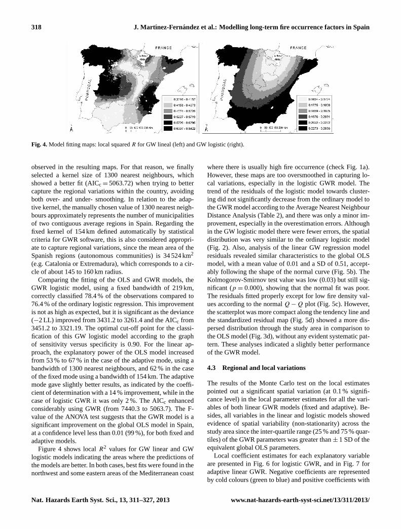
Fig. 4.Model fitting maps: local squaredR for GW lineal (left) and GW logistic (right).
observed in the resulting maps. For that reason, we finallyselected a kernel size of 1300 nearest neighbours, whichshowed a better fit (AICc = 5063.72) when trying to bettercapture the regional variations within the country, avoidingboth over- and under- smoothing. In relation to the adap-tive kernel, the manually chosen value of 1300 nearest neigh-bours approximately represents the number of municipalitiesof two contiguous average regions in Spain. Regarding thefixed kernel of 154 km defined automatically by statisticalcriteria for GWR software, this is also considered appropri-ate to capture regional variations, since the mean area of theSpanish regions (autonomous communities) is 34 524 km2
(e.g. Catalonia or Extremadura), which corresponds to a cir-cle of about 145 to 160 km radius.
Comparing the fitting of the OLS and GWR models, theGWR logistic model, using a fixed bandwidth of 219 km,correctly classified 78.4 % of the observations compared to76.4 % of the ordinary logistic regression. This improvementis not as high as expected, but it is significant as the deviance(−2 LL) improved from 3431.2 to 3261.4 and the AICc from3451.2 to 3321.19. The optimal cut-off point for the classi-fication of this GW logistic model according to the graphof sensitivity versus specificity is 0.90. For the linear ap-proach, the explanatory power of the OLS model increasedfrom 53 % to 67 % in the case of the adaptive mode, using abandwidth of 1300 nearest neighbours, and 62 % in the caseof the fixed mode using a bandwidth of 154 km. The adaptivemode gave slightly better results, as indicated by the coeffi-cient of determination with a 14 % improvement, while in thecase of logistic GWR it was only 2 %. The AICc enhancedconsiderably using GWR (from 7440.3 to 5063.7). The F-value of the ANOVA test suggests that the GWR model is asignificant improvement on the global OLS model in Spain,at a confidence level less than 0.01 (99 %), for both fixed andadaptive models.
Figure 4 shows localR2 values for GW linear and GWlogistic models indicating the areas where the predictions ofthe models are better. In both cases, best fits were found in thenorthwest and some eastern areas of the Mediterranean coast
where there is usually high fire occurrence (check Fig. 1a).However, these maps are too oversmoothed in capturing lo-cal variations, especially in the logistic GWR model. Thetrend of the residuals of the logistic model towards cluster-ing did not significantly decrease from the ordinary model tothe GWR model according to the Average Nearest NeighbourDistance Analysis (Table 2), and there was only a minor im-provement, especially in the overestimation errors. Althoughin the GW logistic model there were fewer errors, the spatialdistribution was very similar to the ordinary logistic model(Fig. 2). Also, analysis of the linear GW regression modelresiduals revealed similar characteristics to the global OLSmodel, with a mean value of 0.01 and a SD of 0.51, accept-ably following the shape of the normal curve (Fig. 5b). TheKolmogorov-Smirnov test value was low (0.03) but still sig-nificant (p = 0.000), showing that the normal fit was poor.The residuals fitted properly except for low fire density val-ues according to the normalQ − Q plot (Fig. 5c). However,the scatterplot was more compact along the tendency line andthe standardized residual map (Fig. 5d) showed a more dis-persed distribution through the study area in comparison tothe OLS model (Fig. 3d), without any evident systematic pat-tern. These analyses indicated a slightly better performanceof the GWR model.
4.3 Regional and local variations
The results of the Monte Carlo test on the local estimatespointed out a significant spatial variation (at 0.1 % signifi-cance level) in the local parameter estimates for all the vari-ables of both linear GWR models (fixed and adaptive). Be-sides, all variables in the linear and logistic models showedevidence of spatial variability (non-stationarity) across thestudy area since the inter-quartile range (25 % and 75 % quar-tiles) of the GWR parameters was greater than± 1 SD of theequivalent global OLS parameters.
Local coefficient estimates for each explanatory variableare presented in Fig. 6 for logistic GWR, and in Fig. 7 foradaptive linear GWR. Negative coefficients are representedby cold colours (green to blue) and positive coefficients with
Nat. Hazards Earth Syst. Sci., 13, 311–327, 2013 www.nat-hazards-earth-syst-sci.net/13/311/2013/

J. Mart ınez-Fernandez et al.: Modelling long-term fire occurrence factors in Spain 319
Fig. 5. Residual analysis of the GW linear regression model: scatterplots between observed and predicted observations(A), histogram dataplots of the standardized residuals(B), normalQ − Q plot of the standardized residuals(C), and map of the standardized residuals(D).
warm colours (orange to red). The objective of these maps isto explore the spatial variability and to understand better lo-cal and regional variations of the fire occurrence causal fac-tors in Spain, developed in the discussion section.
4.4 Spatial autocorrelation of residuals
Spatial correlograms of the residuals of the linear models(Fig. 8) show that there is significant spatial autocorrelationof the residuals of the OLS regression model up to a distanceof 600 km, while for the residuals of the GWR model the au-tocorrelation has been reduced significantly but still exists inrelative short lag distances, up to approximately 110 km (Ta-ble 4). Less structured residuals have been observed in otherstudies dealing with GWR (Koutsias et al., 2010), indicatingthat although the method does not directly address spatial au-tocorrelation issues (Jetz et al., 2005), it provides a solutionto the problem of spatially autocorrelated errors (Propastinand Kappas, 2008).
5 Discussion
In both regression modelling approaches there were impor-tant variables related with land and population abandonment,
agrarian activities, or development processes, in addition toforest properties and climatic variables. However, only twovariables, precipitation and population decrease, were com-mon between the two approaches, indicating different under-lying mechanisms for fire presence and for fire density atthe community level. In this discussion we analyze the mostimportant explanatory variables for each model and exploretheir spatial variations according to GWR local parameters(Figs. 6 and 7). Some variables presented high variability inexplaining the dependent variable, occasionally even beingcontradictory to the global coefficients.
5.1 Driving factors of long-term fire presence
The percentage of wildland area was the most important fac-tor to discriminate non fire-prone from fire-prone municipal-ities (defined as those in which at least one fire was observedduring the 25-yr period studied). This is reasonable since theprobability of fire ignition and spread was very low in placeswith a very low percentage of forest and natural cover, asfuels are very scarce or non-existing. The influence of thisvariable was higher in the south of the country, as observed inFig. 6. Another important variable was forest–cultivated landinterface (ICFSUPP), which is related to agricultural activ-ities where fire is frequently used in arable and crop lands,
www.nat-hazards-earth-syst-sci.net/13/311/2013/ Nat. Hazards Earth Syst. Sci., 13, 311–327, 2013

320 J. Martınez-Fernandez et al.: Modelling long-term fire occurrence factors in Spain
Fig. 6. Local coefficients for GW binary logistic model using a fixed bandwidth of 219 km. Negative coefficients are mapped with coldcolours (green) and positive with warm colours (orange to red). Variable names and their descriptions are in Table 1.
Table 4.Moran’s Index Summary for different band distances on the Linear GWR residuals.
Threshold Distance 90 km 100 km 105 km 110 km 120 km 154 km
Moran’s Index 0.007316 0.003598 0.001945 0.00088−0.00041 −0.00021Expected Index −0.000143 −0.000143 −0.000143 −0.00014 −0.000143 −0.00014z-score 8.939 4.95545 2.898472 1.48896 −0.421 −0.125p-value 0.000 0.000001 0.00375 0.13650 0.674 0.900residual pattern interpretation clustered clustered clustered random random random
very close to or intermixed with forest areas. This variablewas less relevant in the Iberian Mountain System and EbroRiver Depression. The importance of the forest–agricultureinterface (FAI) in forest fires in Spain was observed in pre-vious studies (Martınez et al., 2009, Ortega et al., 2012;Gonzalez-Olabarrıa et al., 2012), which found that the land-scapes most vulnerable to fire were those with fine-grainedforest–agriculture mixtures or mosaics, where the human-
caused fires were more intense than homogeneous and non-fragmented landscapes.
Variables DIS50 91 (population decrease between 1950and 1991) and DISSAU (decrease in agricultural area be-tween 1989 and 1999) were positively correlated with theoccurrence of at least one fire event. Both variables can beassociated with abandonment of land and traditional activi-ties and the movement of population from rural and moun-tainous areas to lowlands and urban areas. A consequence of
Nat. Hazards Earth Syst. Sci., 13, 311–327, 2013 www.nat-hazards-earth-syst-sci.net/13/311/2013/

J. Mart ınez-Fernandez et al.: Modelling long-term fire occurrence factors in Spain 321
Fig. 7. Local coefficients for adaptive GWR linear model using a bandwidth of 1300 nearest neighbours. Negative coefficients are mappedwith cold colours (green to blue) and positive with warm colours (orange to red). Variable names and their descriptions are in Table 3.
land abandonment is fuel build-up. Instead, according to thepositive correlations observed for these variables, in munic-ipalities with population reduction and land abandonment,fires were expected in cases where the decrease is lower.Under this demographic and social context, areas maintain-ing a relatively higher agricultural population are more fireprone. This is an example of the contradictory types of rela-
tionships between the explanatory and response variables inwildfire occurrence modelling. According to the local coef-ficient maps in the NW, the occurrence of at least one fire ismore closely associated to the population presence than therural exodus or land abandonment (DIS50 91), while in thesouth, the presence of agricultural land (DISSAU) is moreinfluential (Fig. 6).
www.nat-hazards-earth-syst-sci.net/13/311/2013/ Nat. Hazards Earth Syst. Sci., 13, 311–327, 2013

322 J. Martınez-Fernandez et al.: Modelling long-term fire occurrence factors in Spain
Fig. 8.Spatial correlograms of the residuals of the OLS linear regression (left) and GWR regression modelling (right).
Population and agricultural area decrease are also closelyrelated with the population potential (POTDEN), a similarconcept of population density or human presence, which isfurther associated with the probability of fire ignition andarea burned. This has a positive influence in many studies(Cardille et al., 2001; Maingi and Henry, 2007; Romero-Calcerrada, 2008; Catry et al., 2009; Sebastian-Lopez et al.,2008; Martınez et al., 2009; Marques et al., 2011; Nunes,2012) or a negative relationship for some areas in other stud-ies (Narayanaraj and Wimberly, 2012; Sa et al., 2011). Addi-tionally, the previously mentioned variables were also relatedwith the CORINE land use class “agriculture but with signif-icant areas of natural vegetation” (CL21 PM), showing thatfire occurrence was more likely in municipalities where agri-cultural and forest areas are intermixed, similar to what hasbeen reported by Ortega et al. (2012). Recently, when try-ing to explain the extreme 2007 fires in the Greek Pelopon-nese, Koutsias et al. (2012) observed that the CORINE landcover category “agricultural land, highly interspersed withsignificant areas of natural vegetation” was the most affectedby fire, reflecting the encroachment of natural vegetation inabandoned fields and also recent patterns of evolution in thewildland–rural interface where agricultural land is increas-ingly intermixed with natural vegetation.
Together with land abandonment and population decrease,the economic value of lands and forests was identified as afactor of human-caused fires due to a decreasing involve-ment in conservation and land management by the remain-ing rural population. In this sense, the NOGESPF variablein the model was positively correlated with fire occurrence.This variable measures the percentage of forest surface withless management, control and planning over time, which inSpain is the private forest land, land belonging to local au-thorities with free use, consortiums and neighbouring forests.All these kinds of properties have a generally worse conser-vation and protection status than national, regional or publicforest. Local coefficients for this variable were positive inthe Mediterranean coast and negative in the NW. Padilla andVega-Garcia (2011) found that several variables related toforest ownership (private, public and communal areas) weresignificant for the northern ecoregions of Spain.
Finally, climatic variables were also found to be relevantfactors to explain fire occurrence. Mean summer tempera-ture and mean annual precipitation are important factors, es-pecially in the warmer areas of the E and SE. Many studies(Shyphard et al., 2008; Drever et al., 2008; Vilar et al., 2010;Padilla and Vega-Garcıa et al., 2011; Oliveira et al., 2012,Sa et al., 2011; Narayarnaraj and Wimberly, 2012; Nunes,2012) selected several climatic variables as very significantin their fire models – some related to precipitation, such asfire-season and off-season precipitation, precipitation sea-sonality, soil water storage and soil moisture anomaly – andothers related to temperature, especially the maximum tem-perature in the driest season.
5.2 Driving factors of long-term fire density
Summer temperature was not a significant factor to explainfire density in linear regression, unlike in the logistic model(fire/no fire incidence). However, the mean annual precipita-tion was the most important factor to explain forest fire den-sity (Table 3). Local coefficients for this variable were posi-tive across almost the entire country, especially in the SE andsome parts of the inland west, which may be related to theimpact of rainfall on fuel availability, particularly in the drySE regions of Spain. The exception was observed in the NEand central Pyrenees (negative local coefficients) where rain-fall occurs also in the summer and therefore the fire seasontends to be shorter, although this also happens in other partsof the country where positive coefficients are found. Oliveiraet al. (2012) pointed out that the most important variables re-lated with fire density distribution in the EUMed region wereoff-season precipitation (positive influence related to vegeta-tion growth and fuel accumulation) and fire season precipi-tation, with a negative relationship limiting fire ignition andspread. Sa et al. (2011) indicate that in the drier areas of sub-Saharan Africa there is a positive relationship between fireincidence and soil water, which is important for vegetationgrowth.
The density of agricultural properties (PARSEXP)was positively related to fire occurrence, suggesting thathighly partitioned agricultural properties increased the
Nat. Hazards Earth Syst. Sci., 13, 311–327, 2013 www.nat-hazards-earth-syst-sci.net/13/311/2013/

J. Mart ınez-Fernandez et al.: Modelling long-term fire occurrence factors in Spain 323
human-caused ignition risk. In combination with the vari-able “density of agricultural machinery” (MAQUIND), thisindicates that, the higher the number of properties and ma-chines, the more likely conflicts and negligence become. Fireis one of the preferred tools to eliminate stubble, weeds,field margins, hedges and shrubs, and to reclaim abandonedlands (Leone et al., 2003), especially in areas where agricul-tural parcel density is very high and irregularly distributedin space. In Spain, more than 20 % of the fires that occurredwithin the 25-yr period (1980–2004) were caused by inten-tional or negligent agricultural burnings and other burningsof shrublands to regrow or maintain pastures for livestock,although the importance of these causes could be far greater,and actually estimated at 45 % (Leone et al., 2009; Kout-sias et al., 2010). In addition, as explained in Martınez etal. (2009, p. 1248), in many cases mechanization implies awillingness to obtain more space and land for cultivation,and fires are one of the tools to achieve it. Also, more in-tensive agricultural activity, promoted by mechanization overtime, may increase the need to burn more stubble, agricul-tural residues and prunings, as well as a higher number ofignitions produced by accidental sparks deriving from en-gine operation. Similar agriculture related variables have alsobeen used in other fire modelling studies (Sebastian-Lopezet al., 2008; Catry et al., 2009). According to the spatial dis-tribution of the local coefficients, we identified areas wherethe expected direction in relation to high fire density exhib-ited opposite trends to the global model. This is the case ofvariable PARSEXP in the Valencia Region and the northernplateau (especially in the “Ribera del Duero” region), wherelocal negative coefficients were found. Both areas have highfragmentation of small-holdings both in irrigated and in rain-fed arable land agriculture, but they have few forested ar-eas and a landscape with less wildland–agrarian mosaics.However these areas present high and positive coefficientsfor variable agricultural machinery. Instead, in the easternCantabrian regions (Basque Country and Cantabria) and theGuadalquivir depression in the SW, variables MAQUIND(agricultural machinery) and TIT55 P (percentage of oldowners of agrarian holdings) showed the opposite trends. Insome of these humid Atlantic environments of the north, live-stock and forestry are more important than agriculture. Thesouthwestern Guadalquivir area presented one of the low-est indices in the number of agricultural machines comparedwith other irrigated areas of the country.
The mean municipality altitude (ALTMEAN) variablewas the third most explanatory in the model. The global coef-ficient and most of the local coefficients throughout the coun-try were negative, so at lower altitudes more fire densitieswere expected, especially in the central part of the countryand the eastern coast. However, we observed a positive influ-ence across the entire S of the country and in the NW (Gali-cia). Coefficients were neutral (close to 0) in the N of Aragonand the central Pyrenees in the upper mountains. Other stud-ies showed that elevation presents contrasting relationships
with fire occurrence. Some studies found a positive influence(Catry et al., 2009; Marques et al., 2011) as a consequenceof pastoral burns (renovation of pastures for livestock) or ahigher frequency of lightning in higher altitudes (Vazquezand Moreno, 1998; Narayanaraj and Wimberly, 2012), whileother studies found a negative correlation (Vasconcelos et al.,2001; Sebastian-Lopez et al., 2008; Gonzalez-Olabarrıa etal., 2012; Vilar et al., 2010; Padilla and Vega-Garcia, 2011),suggesting that lower elevations tend to be the more xericplaces, with dryer fuels and less productivity. However, fueldry-out is probably a function of the temporal distribution ofprecipitation, which in the Mediterranean area is very highin summer due to the seasonal drought. In addition, whenaltitude increases, the vegetation loading tends to decreasewith more unburnable areas appearing (rocks, sparse vege-tation, ice, etc.) although only over a certain height. Unlikelightning-caused fires, Narayanaraj and Wimberly (2012) de-tected a negative association between elevation and slope andhuman-caused fires in a mountain area of Washington State.Similarly, Vilar et al. (2010) found a less intense land useat high elevations in the Madrid Region. In some regions ofSpain, as in other parts of the world, population, roads andsome land uses responsible for the higher number of ignitionsare concentrated in coastal areas, decreasing with increasingelevation (Badia-Perpinya and Pallares-Barbera, 2006). Thesame conclusions about how topography reflects the loca-tions of human activities in relation to fire ignitions are indi-cated for a region of China by Xu et al. (2006), showing thatthe anthropogenic factors are closely related to fires when al-titudes of forests are lower than 900 m. However, at higherelevations their influence is much lower. In other studies thetopography effect has been related with fires, using variablesrelated with roughness or terrain shape index (Dickson et al.,2006, Nunes, 2012; Padilla and Vega-Garcia, 2011; Naraya-naraj and Wimberly, 2012).
As in the logistic model, population decrease between1950 and 1991 (DIS50 91) was found to be a relevant ex-planatory variable. Besides, the inclusion in the model ofDIS TIT (decrease of the number of owners of agrarian hold-ings 89–99) reinforces the idea of the relationship betweenland abandonment and rural exodus, with a high fire risk(Hill et al., 2008; Nunes, 2012). The local coefficient mapsof these two variables portrayed two patterns: (1) on onehand, in the east of the country, fires are related to populationabandonment and rural exodus, with the resulting accumula-tion of fuels, but at the same time there is some maintenanceof agricultural activities related to fires because the variableDIS TIT correlates positively with fire density; and (2), incontrast to this trend, the western region, particularly in theNW, DIS 50 91 has positive correlation with fires, indicatinga further influence of the population presence on fires. How-ever, in these western areas, DISTIT correlates negativelyto fires, so if agricultural land owners decline and agricul-tural activities are abandoned, fires tend to be more frequent,mainly because of greater fuel accumulation. In addition, in
www.nat-hazards-earth-syst-sci.net/13/311/2013/ Nat. Hazards Earth Syst. Sci., 13, 311–327, 2013

324 J. Martınez-Fernandez et al.: Modelling long-term fire occurrence factors in Spain
this NW area (Galicia), which is the most fire affected region,we found strong positive coefficients with the variable ageingagricultural population (TIT55 P), because in this region theolder population is the more accustomed to use fire in farm-ing works, as they did in their youth (Velez, 2009). This vari-able also suggests the impact of the land abandonment pro-cess in increasing fire frequency. A similar trend was also ob-served by Nunes (2012) in Portugal, where the ageing indexcorrelates negatively with the density of the population andis positively associated with agricultural land abandonment.The same process has been pointed out for the MediterraneanEuropean Basin using the difference of the youth index be-tween 1990 and 1960 (Koutsias et al., 2010) as a proxy.
Two of the variables relate fires to forestry and landscapefeatures. Thus, more fires were found in landscapes with alarge percentage of shrublands and grasslands (DESARP),especially in the Cantabrian Mountains and N coast wherethere are numerous pastoral fires to create, maintain, or re-grow pastures for livestock (Moreira et al., 2011). Many stud-ies have confirmed that shrubland is one of the most fire af-fected land cover types (Nunes et al., 2005; Sebastian-Lopezet al., 2008; Catry et al., 2009; Moreira et al., 2009; Bajoccoand Ricotta, 2008; Nunes, 2012; Oliveira et al., 2012) due toa combination of factors: “a higher rate of fire spread, a largerfrequency of ignitions (e.g. to create pastures) and a lowerfire fighting priority” (Marques et al., 2011, p. 783). In sub-Saharan Africa the herbaceous vegetation proportion is thevariable best related with fire incidence (Sa et al., 2012). Onthe other hand, more fire density was found in Spanish land-scapes with high fragmentation (FRAG7× 7), especially inthe three main river depressions where agriculture dominates(Duero, Ebro and Guadalquivir) and where there is less forestcover. Heterogeneous and interspersed patterns composed byspatially separated patches with different land uses presentshigher ignition frequencies (Ortega et al., 2012; Ruiz-Mirazoet al., 2012).
Finally, two variables were related, in general, to humanpresence and accessibility. Road density (ROADDEN), thesame as road distance, has very often been found to be relatedto human accidental or negligent fires (Cardille et al., 2001;Vasconcellos et al., 2001; Badia-Perpinya and Pallares-Barbera, 2006; Yang et al., 2007; Romero-Calcerrada etal., 2008; Martınez et al., 2009; Catry et al., 2009; Vi-lar et al., 2010; Padilla and Vega-Garcıa, 2011; Gonzalez-Olabarria, 2012; Oliveira et al., 2012; Narayanaraj and Wim-berly, 2012), as well the density and distance to human set-tlement (ENTSINM). Specifically, the risk appeared to behigher in the urban–forest interface (IUFDEN) zone (Badia-Perpinya and Pallares-Barbera, 2006; Syphard et al., 2007;Catry et al., 2009; Martınez et al., 2009; Romero-Calcerradaet al., 2010; Vilar et al., 2010; Gonzalez-Olabarrıa et al.,2012; Narayanaraj and Wimberly, 2012) where populationand human infrastructure facilities are in contact, close to ordisseminated throughout the forested zones, especially in thevicinity of large cities and tourist resorts (Viegas et al., 2003).
According to the spatial distribution of the local coefficientsof these variables, it might be surprising to find high coef-ficients in areas where the values of these variables are low,such as in the southern part of Central Spain and in the in-land mountains of the south, where a low population density,few population centres and scarce wildland–urban interfacesare found. However, these few places with higher densities ofhuman activities seem to tend to bias the model and thereforeseem to be decisive for the fire occurrence in those areas.
6 Conclusions
In this study we built two complementary models whichcover the whole range of the human-caused fire occurrencein Spain during a 25 yr period. The first model tries to pre-dict and explain fire densities, and the second fire pres-ence/absence. The most influential variables for both mod-els are related to agrarian activities, land abandonment, ru-ral exodus and development processes. Additionally, specifictraits of vegetation, climatology and topography have alsobeen very important, since they affect the initial conditionsenabling fire incidence. The inclusion of these environmentalvariables results in an improvement over the previous model(Martınez et al., 2009), on which this study is based.
Relevant differences between both models are found be-cause only two explanatory variables are common: meanannual precipitation and population decrease. Potentiallyflammable land cover types (total wildland area and agri-cultural/forest interfaces and mosaics) and the mean sum-mer temperature are the main specific variables for the firepresence model. Instead, agricultural fragmentation, eleva-tion, shrublands and grasslands, along with human structures(roads, settlements, etc.) and other rural indicators are spe-cific variables for the fire density model.
However, these stationary models and global regressionapproaches seem to be insufficient to appropriately explainthe underlying fire factors, because all variables selectedshowed significant spatial variations at the regional or lo-cal scale according to the GWR model. Nevertheless, onlysome of them present, in fact, very high variability or con-tradictory relationships with the response variable and/or theglobal trends. For example, the density and fragmentation ofagricultural plots has a negative relationship with fires in re-gions with low forest areas and less wildland–agrarian mo-saics, as along the E coast in the Valencia Region and theeastern part of the northern plateau (Ribera de Duero), andboth areas are characterized by having small-holdings of irri-gated agriculture and also rain-fed arable lands. Also, precip-itation, decrease in owners of agrarian holdings, populationentities or the urban–forest interface present unexpectedlyhigh regression coefficients in areas where those variableshave low original values. Thus, although precipitation seemsto be a very important factor to model fire densities in the dri-est areas of the country, it is not that relevant in other areas
Nat. Hazards Earth Syst. Sci., 13, 311–327, 2013 www.nat-hazards-earth-syst-sci.net/13/311/2013/

J. Mart ınez-Fernandez et al.: Modelling long-term fire occurrence factors in Spain 325
with more rainfall availability. Similarly, the percentage offorest and wildland area has a higher influence in the S of thecountry, which is drier and with less vegetation as comparedto the N. Another interesting pattern is observed between theE and the W–NW where population presence seems to havea further influence on fires, although at the same time im-portant land abandonment processes are observed. In the E,instead, fires seem directly more related to population aban-donment and rural exodus, but also to agricultural activities,though to a lesser degree. Finally, lower altitude seems morerelated with the fire density along the eastern coast and in thecentral part of the country, unlike the pattern observed in theS and NW where higher altitudes present more fire risk. Inthe upper mountains of the Central Pyrenees this relation isneutral.
This analysis is another contribution to the field of firemanagement and fire risk assessment in the Mediterraneancountries, which quantitatively and spatially demonstratedthe importance of considering regional variations and localmodelling as a complement to global and stationary modelsin order to better understand the fire problem over large studyareas.
Acknowledgements.The authors are grateful to Ministry of Agri-culture, Food and Environment of Spain for providing access to firedata base. Comments, suggestions and corrections of the editor andreviewers during the evaluation process are greatly appreciated.
Edited by: K. ChangReviewed by: O. Price and one anonymous referee
References
Avila-Flores, D., Pompa-Garcia, M., Antonio-Nemiga, X.,Rodriguez-Trejo, D., Vargas-Perez, E., and Santillan-Perez,J.: Driving factors for forest fire occurrence in Durango Stateof Mexico: A geospatial perspective, Chinese Geogr. Sci., 20,491–497, 2010.
Badia-Perpinya, A. and Pallares-Barbera, M.: Spatial distribution ofignitions in Mediterranean periurban and rural areas: the case ofCatalonia, Int. J. Wildland Fire, 15, 187–196, 2006.
Bajocco, S. and Ricotta, C.: Evidence of selective burning in Sar-dinia (Italy): which land cover classes do wildfires prefer?, Land-scape Ecol., 23, 241–248, 2008.
Brunsdon, C., Fotheringham, A. S., and Charlton, M.: Geograph-ically weighted regression: a method for exploring spatial non-stationarity, Geogr. Anal., 28, 281–298, 1996.
Carmo, M., Moreira, F., Casimiro, P., and Vaz, P.: Land use and to-pography influence on wildfire occurrence in northern Portugal,Landscape Urban Plan., 100, 169–176, 2011.
Catry, F. X., Rego, F. C., Bacao, F. L., and Moreira, F.: Modelingand mapping wildfire ignition risk in Portugal, Int. J. WildlandFire, 18, 921–931,doi:10.1071/WF07123, 2009.
Cardille, J. A., Ventura, S. J., and Turner, M. G.: Environmental andsocial factors influencing wildfires in the Upper Midwest, UnitedStates, Ecol. Appl., 11, 111–127, 2001.
Charlton, M. and Fotheringham, A. S.: Geographically WeightedRegression. A Tutorial on using GWR in ArcGIS 9.3, avail-able at:http://ncg.nuim.ie/ncg/gwr/GWRTutorial.pdf, NationalCentre for Geocomputation, National University of IrelandMaynooth, Maynooth, County Kildare, Ireland, 25 pp., 2009.
Charlton, M., Fotheringham, A. S., and Brunsdon, C.: Geographi-cally Weighted Regression. VERSION 2.x, User’s Manual andInstallation Guide. National Centre for Geocomputation, Na-tional University of Ireland Maynooth, Maynooth, 33 pp., 2003.
Chuvieco, E., Aguado, I., Yebra, M., Nieto, H., Salas, J., Martın, M.P., Vilar, L., Martınez, F. J., Martın, S., Ibarra, P., De la Riva, J.,Baeza, J., Rodriguez, F., Molina, J., Herrera, M. A., and Zamora,R.: Development of a framework for fire risk assessment usingremote sensing and geographic information system technologies,Ecol. Model., 221, 46–58, 2010.
Dickson, B. G., Prather, J. W., Xu, Y., Hampton, H. M., Aumack, E.N., and Sisk T. D.: Mapping the probability of large fire occur-rence in northern Arizona, USA, Landscape Ecol., 21, 747–761,2006.
Drever, C. R., Drever, M. C., Messier, C., Bergeron, Y., and Flanni-gan, M.: Fire and the relative roles of weather, climate and land-scape characteristics in the Great Lakes-St. Lawrence forest ofCanada, J. Veg. Sci., 19, 57–66, 2008.
FAO: Fire Management – Global Assessment 2006, A ThematicStudy Prepared in the Framework of the Global Forest ResourcesAssessment 2005, FAO, Rome, 2007.
Fotheringham, A. S., Charlton, M., and Brunsdon, C.: The Geogra-phy of Parameter Space: An Investigation of Spatial Nonstation-arity, Int. J. Geogr. Inf. Syst., 10, 605–627, 1996.
Fotheringham, A. S., Charlton, M., and Brunsdon, C.: Two tech-niques for exploring nonstationarity in geographical data, Geo-graphical Systems, 4, 59–82. 1997.
Fotheringham, A. S., Brunsdon, C., and Charlton, M.: Geograph-ically Weighted Regression: The Analysis of Spatially VaryingRelationships, John Wiley and Sons, New York, 269 pp., 2002.
Gonzalez-Olabarria, J. R., Mola, B., Pukkala, T. and Palahı, M.:Using multi-scale spatial analysis to assess fire ignition densityin Catalonia, Spain, Ann. For. Sci., 68, 861–871, 2011.
Hill, J., Stellmes, M., Udelhoven, T., Roder, A., and Sommer, S.:Mediterranean desertification and land degradation: Mapping re-lated land use change syndromes based on satellite observations,Global Planet. Change, 64, 146–157, 2008.
Hope, A. C. A.: A simplified Monte Carlo Significance Test Proce-dure, J. R. Stat. Soc. Ser. B, 30, 582–598, 1968.
Jetz, W., Rahbek, C., and Lichstein, J. W.: Local and Global Ap-proaches to Spatial Data Analysis in Ecology, Global Ecol. Bio-geogr., 14, 97–98, 2005.
Koutsias, N., Martınez, J., Chuvieco, E., and Allgower, B.: Mod-eling Wildland Fire Occurrence in Southern Europe by a Geo-graphically Weighted Regression Approach, in: Proceedings ofthe 5th International Workshop on Remote Sensing and GIS Ap-plications to Forest Fire Management: Fire Effects Assessment,Universidad de Zaragoza, Spain, 57–60, ISBN:84-96214-52-4,2005.
Koutsias, N., Martınez-Fernandez, J., and Allgower, B.: Do factorscausing wildfires vary in space? Evidence from geographicallyweighted regression, GISci. Remote Sens., 47, 1548–1603, 2010.
Koutsias, N., Arianoutsou, M., Kallimanis, A. S., Mallinis, G., Hal-ley, J. M., and Dimopoulos, P.: Where did the fires burn in Pelo-
www.nat-hazards-earth-syst-sci.net/13/311/2013/ Nat. Hazards Earth Syst. Sci., 13, 311–327, 2013
326 J. Martınez-Fernandez et al.: Modelling long-term fire occurrence factors in Spain
ponnisos, Greece the summer of 2007? Evidence for a synergyof fuel and weather, Agr. For. Meteorol., 156, 41–53, 2012.
Krebs, P., Koutsias, N., and Conedera, M.: Modelling the eco-cultural niche of giant chestnut trees in southern Switzer-land: new insights into landscape history through distribu-tion analysis of a heritage, J. Hist. Geogr., 38, 372–386,doi:10.1016/j.jhg.2012.01.018, 2012.
Kwak, H., Lee, W., Saborowski, J., Lee, S., Won, M., Koo, K., Lee,M., and Kim, S.: Estimating the spatial pattern of human-causedforest fires using a generalized linear mixed model with spatialautocorrelation in South Korea, Int. J. Geogr. Inf. Sci., 26, 1589–1602,doi:10.1080/13658816.2011.642799, 2012.
Leone, V., Koutsias, N., Martınez, J., Vega-Garcıa, C., Allgower,B., and Lovreglio, R: The human factor in fire danger assess-ment, edited by: Chuvieco, E., in: Wildland Fire Danger, Esti-mation and Mapping, The Role of Remote Sensing Data, Ser.Rem. Sens., 4, World Scientific Publishing Co. Pte. Ltd, 143–196, ISBN:981-238-569-X, 2003.
Leone, V., Lovreglio, R., Martın, M. P, Martınez, J., and Vi-lar, L.: Human factors of fire occurrence in the Mediterranean,edited by: Chuvieco, E., in: Earth Observation of WildlandFires in Mediterranean Ecosystems, Springer-Verlag, Berlin Hei-delberg, 149–170, ISBN:978-3-642-01753-7,doi:10.1007/978-3-642-01754-411, 2009.
Maingi, J. K. and Henry, M. C.: Factors influencing wildlife occur-rence and distribution in eastern Kentucky, USA, Int. J. WildlandFire, 16, 23–33, 2007.
Martınez, J., Martınez Vega, J., and Martın, M. P.: El factor humanoen los incendios forestales: analisis de factores socio-economicosrelacionados con la incidencia de incendios forestales en Espana,edited by: Chuvieco, E. and Martin, M. P., in:: Nuevas Tec-nologıas para la Estimacion del Riesgo de Incendios Forestales.,Madrid, CSIC, Spain, 101–142, 2004.
Martınez, J., Vega-Garcıa, C., and Chuvieco. E.: Human-causedwildfire risk rating for prevention planning in Spain, J. Environ.Manage., 90, 1241–1252,doi:10.1016/j.jenvman.2008.07.005,2009.
Marques, S., Borges, J. G., Garcia-Gonzalo, J., Moreira, F., Car-reira, J. M. B., Oliveira, M. M., Cantarinha, A., Botequim, B.,and Pereira, J. M. C.: Characterization of wildfires in Portugal,Eur. J. For. Res., 130, 775–784, 2011.
Menard, S. W.: Logistic regression: From introductory to advancedconcepts and applications, Sage, London, 377 pp., 2010.
Moreira, F., Vaz, P., Catry, F., and Silva, J. S.: Regional variationsin wildfire preference for land cover types in Portugal: implica-tions for landscape management to minimise fire hazard, Int. J.Wildland Fire, 18, 563–574, 2009.
Moreira, F., Viedma, O., Arianoutsou, M., Curt, T., Koutsias, N.,Rigolot, E., Barbati, A., Corona, P., Vaz, P., Xanthopoulos, G.,Mouillot, F., and Bilgili, E.: Landscape – wildfire interactionsin Southern Europe: implications for landscape management, J.Environ. Manage., 92, 2389–2402, 2011.
Narayanaraj, G. and Wimberly, M. C.: Influences of forest roadson the spatial patterns of human- and lightning-caused wildfireignitions, Appl. Geogr., 32, 878–888, 2012.
Ninyerola, M. Pons, X., and Roure, J. M.: Atlas Climatico dela Penınsula Iberica, Metodologıa y Aplicaciones en Bioclima-tologıa y Geobotanica. Universidad Autonoma de Barcelona,Bellaterra, Spain. 45 pp., ISBN:932860-8-7, 2005.
Nunes, A. N.: Regional variability and driving forces behind forestfires in Portugal an overview of the last three decades (1980–2009), Appl. Geogr., 34, 576–586, 2012.
Nunes, M. C. S., Vasconcelos, M. J., Pereiram, J. M. C, Dasgupta,N., Alldredge, R. J., and Rego, F. C.: Land cover type and fire inPortugal: do fires burn land cover selectively?, Landscape Ecol.,20, 661–673,doi:10.1007/s10980-005-0070-8, 2005.
Oliveira, S., Oehler, F., San-Miguel-Ayanz, J., Camia, A., andPereira, J. M. C.: Modeling spatial patterns of fire occurrence inMediterranean Europe using Multiple Regression and RandomForest, Forest Ecol. Manag., 275, 117–129, 2012.
Ortega, M., Saura, S., Gonzalez-Avila, S., Gomez-Sanz, V., andElena-Rossello, R.: Landscape vulnerability to wildfires at theforest-agriculture interface: half-century patterns in Spain as-sessed through the SISPARES monitoring framework, Agrofor-est. Syst., 85, 331–349,doi:10.1007/s10457-011-9423-2, 2012.
Padilla, M. and Vega-Garcıa, C.: On the comparative importance offire danger rating indices and their integration with spatial andtemporal variables for predicting daily human-caused fire occur-rences in Spain, Int. J. Wildland Fire, 20, 46–58, 2011.
Poudyal, N. C., Johnson-Gaither, C., Goodrick, S., Bowker, J. M.,and Gan, J.: Locating spatial variation in the association be-tween wildland fire risk and social vulnerability across six south-ern States, Environ. Manage., 49, 623–635,doi:10.1007/s00267-011-9796-z, 2012.
Propastin, P. A. and Kappas, M.: Reducing Uncertainty in Model-ing the NDVI-Precipitation Relationship: A Comparative StudyUsing Global and Local Regression Techniques, GISci. RemoteSens., 45, 47–67, 2008.
Rodrigues, J. and De la Riva, J.: Modelado de la variacion espa-cial de los factores explicativos de la causalidad humana en in-cendios forestales mediante Regresion Logıstica Ponderada Ge-ograficamente, edited by: Martınez-Vega, J. and Martın, M. P ,in: Tecnologıas de la Informacion Geografica en el contexto delCambio Global. Libro de Actas del XV Congreso Nacional deTecnologıas de la Informacion Geografica, Madrid, Spain, 395–406, 2012.
Romero-Calcerrada, R., Novillo, C. J., Millington, J. D. A., andGomez-Jimenez, I.: GIS analysis of spatial patterns of human-caused wildfire ignition risk in the SW of Madrid, Central Spain,Landscape Ecol., 23, 341–354, 2008.
Romero-Calcerrada, R., Barrio-Parra, F., Millington, J. D. A., andNovillo, C. J.: Spatial modelling of socioeconomic data to under-stand patterns of human-caused wildfire ignition risk in the SWof Madrid, Central Spain, Ecol. Modell., 221, 34–45, 2010.
Ruiz-Mirazo, J., Martınez-Fernandez, J., and Vega-Garcıa, C.: Pas-toral wildfires in the Mediterranean: understanding their linkagesto land cover patterns in managed landscapes, J. Environ. Man-age., 98, 43–50, 2012.
Sa, A. C. L., Pereira, J. M. C., Charlton, M. E., Mota, B., Bar-bosa P. M., and Fotheringham, A. S.: The pyrogeography of sub-Saharan Africa: a study of the spatial non-stationarity of fire–environment relationships using GWR, J. Geogr. Syst., 13, 227–248,doi:10.1007/s10109-010-0123-7, 2011.
Sebastian-Lopez, A., Salvador-Civil, R., Gonzalo-Jimenez, J., andSan Miguel-Ayanz, J.: Integration of socio-economic and en-vironmental variables for modelling long-term fire danger inSouthern Europe, European J. Forest Res., 127, 149–163,doi:10.1007/s10342-007-0191-5, 2008.
Nat. Hazards Earth Syst. Sci., 13, 311–327, 2013 www.nat-hazards-earth-syst-sci.net/13/311/2013/

J. Mart ınez-Fernandez et al.: Modelling long-term fire occurrence factors in Spain 327
Syphard, A. D., Radeloff, V. C., Keeley, J. E., Hawbaker, T. J., Clay-ton, M. K., Stewart, S. I., and Hammer, R. B.: Human influenceon California fire regimes, Ecol. Appl., 17, 1388–1402, 2007.
Syphard, A. D., Radeloff, V. C., Keuler, N. S., Taylor, R. S., Haw-baker, T. J., Stewart, S. I., and Clayton, M. K.: Predicting spatialpatterns of fire on a southern California landscape, Int. J. Wild-land Fire, 17, 602–613,doi:10.1071/WF07087, 2008.
SSTARS (Social Sciences Teaching and Research Statistics):Multicollinearity in Logistic Regression. Information Tech-nology Computing Center, University of Kentucky, avail-able at: http://www.uky.edu/ComputingCenter/SSTARS/MulticollinearityinLogisticRegression.htm, last access:10 March 2012.
Tulbure, M. G., Wimberly, M. C., Roy, D. P., and Henebry, G.M.: Spatial and temporal heterogeneity of agricultural fires inthe central United States in relation to land cover and land use,Landscape Ecol., 26, 211–224,doi:10.1007/s10980-010-9548-0,2011.
Vasconcelos, M. J. P., Silva, S., Tome, M., Alvim, M., and Pereira, J.M. C.: Spatial prediction of fire ignition probabilities: comparinglogistic regression and neural networks, Photogramm. Eng. Rem.S., 67, 73–8, 2001.
Vazquez A. and Moreno J. M.: Patterns of lightning- and human-caused fires in peninsular Spain, Int. J. Wildland Fire, 8, 103–115,doi:10.1071/WF9980103, 1998.
Vega-Garcia, C., Woodard, T., Adamowicz, W. L., and Lee, B.,: Alogit model for predicting the daily occurrence of human causedforest fires, Int. J. Wildland Fire, 5, 101–111, 1995.
Velez, R.: La Defensa Contra Incendios Forestales. Fundamentos yExperiencias. McGraw-Hill, Aravaca, Madrid, Spain, 2009.
Viegas, D. X., Allgower, B., Koutsias, N., and Eftichidis, G.: FireSpread and the Urban Wildland Interface Problem, edited by:Xanthopoulos, G., in: Proceedings of the International Workshopon Forest Fires in the Wildland-Urban Interface and Rural Ar-eas in Europe: an integral planning and management challenge,MAICh, Chania, Greece, 22–34, 2003.
Vilar, L., Woolford, D. G., Martell, D. L., and Martın, M. P.: Amodel for predicting human-caused wildfire occurrence in theregion of Madrid, Spain, Int. J. Wildland Fire, 19, 325–337,doi:10.1071/WF09030, 2010.
Wang, Q., Ni, J., and Tenhunen, J.: Application of a Geographically-Weighted Regression Analysis to Estimate Net Primary Produc-tion of Chinese Forest, Global Ecol. Biogeogr., 14, 379–393,2005.
Xu, D. Shao, G. Dai, L. Hao, Z. Tang, L., and Wang, H.: Mappingforest fire risk zones with spatial data and principal componentanalysis, Sci. China Ser. E, 49, 140–149, 2006.
Yang, J., He, H. S., Shifley S. R., and Gustafson E. J.: Spatial pat-terns of modern period human-caused fire occurrence in the Mis-souri Ozark Highlands, Forest Sci., 53, 1–15, 2007.
www.nat-hazards-earth-syst-sci.net/13/311/2013/ Nat. Hazards Earth Syst. Sci., 13, 311–327, 2013