modeling three-dimensional cohesive sediment transport and...
TRANSCRIPT

Yusuke UCHIYAMA
REPORT OF THE PORT AND AIRPORT RESEARCH INSTITUTE Vol44 No1 Copyright copy 2005 the Port and Airport Research Institute All Rights Researved
-20-
Modeling three-dimensional cohesive sediment transport and associated morphological variation in estuarine intertidal mudflats
Yusuke UCHIYAMA
March 2005
Littoral Drift Division Port and Airport Research Institute
Yokosuka JAPAN
REPORT OF THE PORT AND AIRPORT RESEARCH INSTITUTE Vol44 No1 (Mar 2005)
Modeling three-dimensional cohesive sediment transport and associated morphological variation in estuarine intertidal mudflats
Yusuke UCHIYAMA
Synopsis
A numerical model has recently been developed with incorporating a wetting and drying scheme into the Princeton Ocean Model (POM Blumberg and Mellor 1983) to simulate tidal currents in San Francisco Bay CA USA (WD-POM Uchiyama 2004) San Francisco Bay is encompassed by extensive intertidal area including mudflats and salt marshes where flooding and draining are predominant for overlaying hy-drodynamics Intertidal sediment transport and associated topography changes are of interest for coastal engineers (eg Dyer 1986) as well as marine biologists (eg Kuwae et al 2003) whereas no three-dimensional numerical models have been developed thus far to calculate the intertidal sediment transport properly In the present study cohesive sediment transport and bed elevation changes are modeled and adapted to WD-POM to assess intertidal morphodynamics in San Francisco Bay
The cohesive sediment transport model contains settling speeds of cohesive flocs (Burban et al 1990) and the sinksource terms due to deposition (Partheniades 1992) and resuspension (Krone 1962) at the sea-bed The governing equation is transformed into the horizontal orthogonal curvilinear coordinate and the vertical sigma coordinate as used in WD-POM The bed elevation model is also developed based upon the volume conservation of the depositedsuspended sediments and is capable of considering consolidation through sediment porosity
Astronomical tidal oscillations are imposed onto the open boundary condition off Golden Gate (the bay mouth) Neither fluvial sediments nor surface wind stresses are assumed in the computation for the sim-plicity The model outputs exhibit that cohesive sediments are suspended dominantly in the deeper chan-nels while being transported and deposited on intertidal areas fringing the bay The morphological change due to tidal currents during two spring-neap cycles shows that intertidal mudflats tend to slightly be accreted yet channels seem rather eroded These results demonstrate that the intertidal areas play an important role in the sediment budgets in the estuary acting as lsquosinkrsquo of the suspended cohesive sediments under action of the tidal currents
Key Words cohesive sediment transport morphological change intertidal mudflat numerical model
Senior Researcher Littoral Drift Division Marine Environment and Engineering Department 3-1-1 Nagase Yokosuka 239-0826 Japan phone +81-46-844-5045 facsimile +81-46-841-9812 email uchiyamaparigojp
-1-
港湾空港技術研究所報告
第44巻第1号(20053)
内湾干潟海域における3次元凝集性土砂輸送 およびそれに伴う地形変動のモデリング
内山 雄介
要 旨
代表的な 3 次元海洋流動モデルである Princeton Ocean Model(POM Blumberg and Mellor 1983)に適用可能な冠水干出スキームが著者によって開発され米国サンフランシスコ湾の潮
流シミュレーションに適用された(WD-POM Uchiyama 2004)WD-POM では新たに拡張対数
則が導入され潮間帯周辺において水深が極めて浅くなった場合であっても海底面境界層内外
の流速分布構造および底質再懸濁に対して重要な底面シアをより正確に再現することが可能と
なっているサンフランシスコ湾は広大な潮間帯干潟により沿岸部を囲まれた典型的な閉鎖性
内湾であり干出冠水現象が湾内流動に対して重要な役割を果たしているこのような潮間帯
域における底質輸送とそれに伴う地形変化の機構と実態にいては海岸工学分野(例えばDyer 1986)だけではなく海洋生物分野(例えばKuwae et al 2003)においても注目されているし
かしながら潮間帯域の底質輸送を精緻に再現する 3 次元モデルはこれまで提案されていなかっ
たそこで本研究ではWD-POM に適用可能な 3 次元凝集性土砂(cohesive sediment)輸送モデ
ルおよび地形変化モデルを開発しそれらをサンフランシスコ湾に適用して湾内の底質移動海
底地形変動特性を検討する 土砂輸送モデルは沈降速度を考慮した 3 次元の移流拡散方程式を基礎式とし水塊のシアと
凝集性土砂のフロック形成を考慮した沈降速度(Burban et al 1990)海底面における沈降堆積
速度(Partheniades 1992)および再懸濁侵食速度(Krone 1962)の各サブモデルが含まれている
基礎方程式は WD-POM に適合するように 3 次元デカルト座標系から水平直交曲線座標系および
鉛直σ座標系へと変換されている海底地形変動モデルは底質の沈降再懸濁を考慮した海底面
における土砂の体積保存則に基いており底質の間隙率を通じて圧密沈下を考慮できるように定
式化されている 湾口部(Golden Gate 西側)の開境界において天文潮のみを与えて湾内の潮流分布およびそ
れに伴う土砂輸送と地形変化に関する計算を行った本研究では潮流成分による土砂輸送の効果
を検討するため湾北東部の Sacramento-San Joaquin デルタからの淡水流入や海表面における風
応力の作用(吹送流および風波)は考慮していないモデルによる計算結果から凝集性土砂の
再懸濁は湾中央に形成された水深の深い水路部において卓越しており下げ潮流によって潮間帯
周辺を含む浅海域方向に土砂が輸送されて沈降するというメカニズムが卓越することが明らかと
なったこれに対応して二朔望周期(約 28 日間)における潮流による地形変化結果から水路
部では侵食が潮間帯干潟では堆積が卓越していることが分かったすなわち潮間帯干潟域は
内湾全体の流動だけではなく土砂収支の観点からも非常に重要な役割を果たしており潮流に対
しては土砂のldquoシンクrdquoとして機能していることが示された
キーワード凝集性土砂輸送地形変化潮間帯干潟数値モデル
海洋水工部 漂砂研究室 主任研究官 239-0826 神奈川県横須賀市長瀬3-1-1 電話046-844-5045FAX046-841-9812Eメールuchiyamaparigojp
-2-
CONTENTS
Synopsis1
1 INTRODUCTION5
2 STUDY SITE6
3 NUMERICAL MODELING7
31 Cohesive Sediment Transport7 32 Boundary Conditions and Empirical Submodels8 33 Bed Shear Stress and Vertical Mixing Parameterization8 34 Bed Elevation Modeling9
4 RESULTS9
41 Cohesive Sediment Concentrations9 42 Geomorphological Variations12
5 DISCUSSION14
6 CONCLUSIONS15
ACKNOWLEDGEMENTS15
REFERENCES15
-3-
-4-
Modeling three-dimensional cohesive sediment transport and associated morphological response in estuarine intertidal mudflats
1 INTRODUCTION
Intertidal mudflats play a crucial role in the transport of land-sourced sediments and contaminants into estuar-ies Currents and waves interact to erode mudflats and vary with tidal range seasons and episodic events such as storms Sedimentation occurs during relatively calm periods when accretion is higher than erosion (Christie and Dyer 1998 Uchiyama et al 2001 Talke and Sta-cey 2003) Mudflats are recognized to be an important component of the estuarine system particularly with re-gard to sediments contaminants and organic matter be-cause they provide an extensive boundary condition (Dyer 1998) Hydrodynamics sediment transport and associated morphological variations have been investi-gated mostly through field measurement programs par-ticularly during the late 1990rsquos (eg Wood et al 1998 Whitehouse and Mitchener 1998 Widdows et al 1998 Li and Parchure 1998 Van der Lee 1998 Van der Lee 2000 Whitehouse et al 2000) Intertidal sediment transport and associated topography changes are of in-terest not only for coastal engineers and physical ocean-ographers (eg Dyer 1986) but also aquatic biochemists and marine biologists (eg Kerner 1993 de Jonge and van Beusekom 1995 Asmus et al 1998 Kuwae et al 1998 Cabrita and Brotas 2000 Christensen et al 2000 Kuwae et al 2003)
Effort has also been made to develop numerical mod-els for intertidal areas while wetting and drying (emer-gence during high waters and immergence during low waters) are essential to the intertidal hydrodynamics but it is generally difficult to implement the wettingdrying capability into three-dimensional numerical models Nevertheless a number of cohesive sediment transport models have been developed involving Sheng and Lick (1979) Thomas and McAnally (1985) Zeigler and Lick (1988) Hayter and Pakala (1989) Barros and Baptista (1989) Lee et al (1994) Ziegler and Nisbet (1994 1995) McDonald and Cheng (1997) Shrestha et al (2000) Inagaki (2000) HydroQual Inc (2002) Naka-gawa (2003 2005) Bricker et al (2004) and others Most of them are based on 2DH hydrodynamic models such as TRIM (Cheng et al 1993) which can readily be applied to intertidal simulations (McDonald and Cheng
1997) However intertidal mudflats extend in the estu-aries where baroclinic motion is effectively significant for the hydrodynamics (Ralston and Stacey 2004) and thus three-dimensional prognostic models are requisite for exploring intertidal sediment transport Among the models referred to above Inagaki (2000) Nakagawa (2003 2005) and Bricker et al (2004) developed the three-dimensional intertidal cohesive sediment transport models Inagaki (2000) and Bricker et al (2004) used a model based upon TRIM-3D (Casulli and Cattani 1994 Gross et al 1998) which is originally capable of simu-lating inundation and drainage occurred on intertidal mudflats However both of them paid no attention to intertidal processes whereas the simulations are done for South San Francisco Bay which is fringed by extensive intertidal areas and man-made salt ponds (Siegel and Bachand 2002) Nakagawa (2003 2005) employed the PHRI siltation model developed by Tsuruya et al (1990) with implementing a wetting and drying capability to simulate cohesive sediment transport in Ariake Bay Ja-pan still he mentioned nothing about effects of the inter-tidal mudflats surrounding the estuary on its hydrody-namics and sediment transport
A wetting and drying scheme (WDS) has recently been developed and incorporated into the Princeton Ocean Model (POM Blumberg and Mellor 1983 1987) to simulate tidal currents in San Francisco Bay (WD-POM Uchiyama 2004) The WDS is different from the other schemes proposed by Zheng et al (2003) Xie et al (2004) and Oey (2005) in representation of bed boundary layer since the extended logarithmic law was newly introduced into the WDS so as to accurately esti-mate bed shear stresses and resultant sediment resuspen-sion and deposition in extremely shallow basins such as intertidal mudflats The accuracy of WD-POM was verified by comparing the observed tidal surface eleva-tions and 3D current velocities to the model outputs The primary advantage of WD-POM over TRIM-3D and the PHRI model is its ability to evaluate the 3D hydro-dynamics and associated scalar (salinity temperature sediments etc) transport even though water depth ap-proaches zero in response to tide This is mainly due to the coordinate systems that these models employ Al-though TRIM-3D and the PHRI model are configured on
-5-
Yusuke UCHIYAMA
Figure 1 Location of the st marks correspond to the turb
the 3D Cartesian coordinate level vertical coordinate (wheparallel to a certain datum plaoriginal version of POM) is ovilinear coordinate with thesigma-coordinate (Uchiyamaconclusion of the study by USan Francisco Bay the intertremarkably alter and control bayment since the intertidal ently enhances refraction antidal waves while attenuatinconsequent phases owing to inshallow regions
The objectives of the presesive sediment transport andvariations to incorporate theexamine effects of intertidal tdrodynamics and resultant seCohesive sediments are intrichydrodynamics pore water and bioturbation as reviewed
udy San Francisco Bay amp Sacramento-San Joaquin Delta system California USA Circleidity measurement sites by Buchanan and Ruhl (2001) summarized in Table 3
with a so-called the multi-re vertical grids are aligned ne) WD-POM (and also its n the 2DH orthogonal cur- vertical terrain-following 2004) The important chiyama (2004) is that in
idal mudflats are found to hydrodynamics of the em-sloping bathymetry appar-d shoaling of propagating g propagating speeds and creasing bed friction in the
nt paper are to model cohe- associated morphological m into WD-POM and to opography on estuarine hy-diment transport processes ately influenced by ambient dynamics biostabilization in Black et al (2002) To
avoid this complexity the model presented here simply formulated by using the standard parameterizations such as by Krone (1962) for the resuspension rate by Parthe-niades (1992) for the deposition rate and by Burban et al (1990) for the settling speeds Attempts are made to extract some crucial properties of sedimentary dynamics from the computational results by paying careful atten-tion to effects of the intertidal shallow topography 2 STUDY SITE
San Francisco Bay California USA (Figures 1 and 2) consisting of South Bay Central Bay San Pablo Bay and Suisun Bay is chosen for the study site The bay is a tidally-forced semi-enclosed estuary encompassed by wide-spreading intertidal area comprising mudflats and salt marshes where flooding and draining are predomi-nant for overlaying hydrodynamics San Francisco Bay has the surface area of about 1240km2 and the intertidal mudflats of about 200km2 The Sacramento-San Joa-quin delta system enormously supplies the freshwater and associated sediment influx sourced by the Sierra
-6-
Modeling three-dimensional cohesive sediment transport and associated morphological response in estuarine intertidal mudflats
MtBtsd1b(2aWsem 3 3
1Ml
Figure 2 The bathymetric map of San Francisco Bay California USA (left) and the computational grid alignment us-ing the horizontal orthogonal curvilinear transformation (right) The bathymetry is relative to the MLLW level
ountains and Central Valley to the northeastern part of he bay ie Suisun Bay San Pablo Bay and Central ay (Conomos et al 1985) By contrast South Bay
he southernmost part of San Francisco Bay is often de-cribed as a tidally oscillating lagoon with density-riven exchanges with the northern reach (Gross et al 999) Limited number of numerical simulations have een performed for San Francisco Bay by Cheng et al 1993) and McDonald and Cheng (1997) using TRIM-D by Gross et al (1998) Inagaki (2000) and Bricker et l (2004) with TRIM-3D and by Uchiyama (2004) with D-POM since emersion and immersion are indispen-
able to hydrodynamics of the embayment although gen-rally laborious to incorporate into 3D hydrodynamic odels
NUMERICAL MODELING
1 Cohesive Sediment Transport
Princeton Ocean Model (Blumberg and Mellor 1983 987) consists of a set of the 3D primitive equations ellor-Yamada level 25 turbulent closure model (Mel-
or and Yamada 1982 Galperin et al 1988) for vertical
eddy coefficients and a Smagorinsky-type parameteriza-tion for horizontal mixing with the Boussinesq approxi-mation and hydrostatic assumption The governing equations are converted from the 3D Cartesian coordi-nate into the orthogonal curvilinear coordinate (horizon-tal) and σminuscoordinate (vertical) to smoothly follow com-plex terrain geometries and marine bathymetries as shown in Figure 2 A wetting and drying feature is implemented by Uchiyama (2004) to deal with hydrody-namics in extremely shallow basins composed of inter-tidal flats and salt marshes The cohesive sediment transport model to be coupled with WD-POM is devel-oped here as expressed in Eqn (1)
( )
CH
s
FCD
K
CWy
VCDx
UCDt
CD
+⎥⎦⎤
⎢⎣⎡
partpart
partpart
=
partpart
+part
part+
partpart
+part
part
σσ
σω -
(1)
where (U V ω) 3D velocity vector D total depth (=H+η H depth η surface elevation) C cohesive sediment concentration Ws settling velocity KH verti-cal eddy diffusivity and FC the horizontal diffusion terms Equation (1) is converted from the regular Car-tesian coordinate into the 2D horizontal curvilinear and
-7-
Yusuke UCHIYAMA
Table 1 Summary of the hydrodynamic and numerical parameters used in the San Francisco Bay-simulation
definition parameter value time step for external mode (2D) ∆te 5 s time step for internal mode (3D) ∆ti 50 s Smagorinsly constant AM 02 density of seawater ρ 1025 kgm3
roughness height z0 1 cm critical depth used in WDS dcr 20 cm minimum depth used in WDS dmin 5 cm scaling factor used in WDS δ 1 cm
( see Uchiyama 2004)
Table 2 Sedimentological parameters used in the San Francisco Bay-simulation
definition parameter value initial sediment concentration C|t=0 0 mgl roughness height for sediments zb 05 cm dry density of sediments ρs 20 kgm3
porosity of sediments λs 05 minimum τb for erosion τbe 015 Pa minimum τb for deposition τbd 003 Pa constant erosion probability Pe 5times10-6 kgm2s
vertical sigma coordinate as used in WD-POM Set-tling velocity Ws is unchanged in Eqn (1) after the con-version into a σ-coordinate system (Wang 2001 2002) The horizontal advection terms (the second ant third terms in the left hand side) are calculated with the Smo-larkiewiczrsquos iterative upstream scheme (Smolarkiewicz 1984) All the terms in Eqn (1) are solved explicitly except the vertical diffusion term 32 Boundary Conditions and Empirical Sub-models
The boundary conditions for Eqn (1) at the surface and seabed are defined as
00 rarr=⎟⎠⎞
⎜⎝⎛
partpart σσC
DKH at sea surface (2)
1 minusrarrminus=⎟⎠⎞
⎜⎝⎛
partpart σσ pr
H DECD
K at seabed (3)
where Er Dp erosion and deposition rates at the seabed empirically formulated The source term Er is sim-plistically evaluated to represent resuspension of cohe-sive sediments from the bed in accordance with the con-ventional formulation using the threshold stress τbe for
the bed shear stress τb and a constant erosion probability Pe (Krone 1962 Ariathurai and Krone 1976)
⎪⎩
⎪⎨
⎧
lt=
ge⎟⎟⎠
⎞⎜⎜⎝
⎛ minus=
bebr
bebbe
beber
whenE
whenPE
ττ
τττ
ττ
0
(4)
where Pe the constant erosion probability τbe the criti-cal bottom shear stress for erosion Similarly the sink term Dp in Eqn (3) can be calculated by using the parameterization by Partheniades (1992)
dsp PCWD = (51)
02
20
211 ωπ
ω
dePY
d int infinminus
minusminus= (52)
⎥⎦
⎤⎢⎣
⎡⎟⎟⎠
⎞⎜⎜⎝
⎛minussdot= sdot bdeY
bd
b τ
ττ 2711250log042 (53)
where Pd the deposition probability ω 0 a dummy vari-able and τbd the bottom shear stress below which Pd=1 (dynecm2)
Settling velocity Ws of cohesive flocs is calculated with the parameterization by Burban et al (1990) in
-8-
Modeling three-dimensional cohesive sediment transport and associated morphological response in estuarine intertidal mudflats
which flocculation is dependent on the product of local concentration and vertical shear stress in water column
( )βα CGWs = (61)
2122
zz ⎥⎥⎦
⎤
⎢⎢⎣
⎡⎟⎠⎞
⎜⎝⎛
partpart
+⎟⎠⎞
⎜⎝⎛
partpart
=VUKG Msρ (62)
in which ρs dry density of suspended medium KM ver-tical eddy viscosity α β the empirical non-dimensional constants Ws C and G are expressed in mday mgL and dynecm2 respectively The above equation im-plicitly incorporates the effect of internal shear stress G on aggregation and settling For saltwater suspensions Burban et al (1990) estimated values of α and β to be 242 and 022 (HydroQual Inc 2002) 33 Bed Shear Stress and Vertical Mixing Parameterization
Bed shear stress for sediments is formulated with slightly being modified based on the extended logarith-mic law to be
bbdsb uuC rrρτ = (71)
2
0ln1minus
⎥⎦
⎤⎢⎣
⎡⎟⎟⎠
⎞⎜⎜⎝
⎛ +=
bd z
zzCκ
(72)
where κ the von Karman constant Cd bed friction coef-ficient ub the bottom-most horizontal velocity vector z+ z0 height of ub relative to the bed z0 the roughness height and zb the roughness height for sediments To-gether with Eqn (7) leaving the determination of l un-changed where l is turbulent macroscale KM and the vertical eddy diffusivities KH and Kq must be slightly al-tered as proposed in Uchiyama (2004) so that
( )(( ) ⎪
⎭
⎪⎬
⎫
+=+=+=
0
0
0
zlqSKzlqSKzlqSK
HH
MM
κκκ
) (8)
where SM SH and Sq are the stability functions and q is the square root of TKE multiplied by 2 used in the Mel-lor-Yamada level 25 sub-model in POM
34 Bed Elevation Modeling
Bathymetry changes can be evaluated from the vol-ume conservation of sediments at the bed varying with erosion and deposition rates computed in the model
( ) (9) pr
ss
b DEtdhd
minus=ρλ
1
where hb bed elevation λs porosity of the bed sedi-ments Although the previous studies have often intro-duced a ldquolayeredrdquo bed model (Hayter 1983 McDonald and Cheng 1997 HydroQual Inc 2002) to incorporate consolidation of deposited sediments and vertical distri-bution of the dry density of sediments in the bed and the critical shear stress into the numerical models (Tsai and Lick 1987 MacIntyre et al 1990) it contains many unknown tuning parameters In the present study the bed elevation model is simplistically formulated to avoid intricate uncertainty 4 RESULTS 41 Cohesive Sediment Concentrations
The horizontal grid alignment of San Francisco Bay is displayed in Figure 2 A total of 45 x 160 horizontal cells and 10 vertical σ-layers are defined in the simula-tion as used by Uchiyama (2004) Astronomical tidal oscillations are imposed on the open boundary condition off Golden Gate (the bay mouth) Neither fluvial sedi-ments nor surface wind stresses are assumed in the com-putation for the simplicity The elevation condition is applied to the open boundary a spatial gradient (the first order differentiation) of elevation velocities q2 q2l and C are set to be zero The hydrodynamic sedimen-tological and numerical parameters used in the simula-tion are listed in Tables 1 and 2 The sedimentological parameters employed here are generally standard values not calibrated with field data since the simulation solely considers tidal currents so it would have almost no meaning to compare with the observed data quantita-tively Nevertheless the computed spatial distribution of sediment concentrations and morphological variations indicate a fairly reasonable agreement with the observed results as demonstrated later
-9-
Yusuke UCHIYAMA
Msdl
Figure 3 Bihourly evolution of the cohesive sediment concentrations (black-white colors) and 3D horizontal velocityvectors (white arrows) at the first σ-layer (surface) during a ebbing phase in a spring tide on the 108th and 109th Julianday in 2003 (UTC) The contour intervals are set to be 50mgl
The starting date of the simulation coincides with arch 29 2003 (the 88th Julian day in 2003) and a
imulation spin-up (McDonald and Cheng 1997) is con-ucted for the first 12 days to attain a dynamically equi-ibrium distribution of the sediment concentrations since
the simulation starts with zero concentration in the whole domain at t=0s The last 28 days (ie two spring-neap cycles) are utilized in the following analysis and thus the total duration of the computation is 40 days Water surface elevations and 3D tidal current velocities at mul-
-10-
Modeling three-dimensional cohesive sediment transport and associated morphological response in estuarine intertidal mudflats
Figure 4 Same as Figure 3 but during a flooding phase
tiple locations along the coast line of San Francisco Bay have already validated with the observed data to repre-sent that WD-POM is able to accurately reproduce the hydrodynamics in the whole bay (Uchiyama 2004)
Figures 3 and 4 show the bihourly development of the sediment concentrations and the 3D horizontal cur-rent velocity vectors at the first σ-layer for 14 hours on the 108th to 109th Julian day in 2003 in UTC The model outputs exhibit that during a spring tide cohesive
-11-
Yusuke UCHIYAMA
Table 3 Statistical summary of the near-bottom suspended sediment concentrations measured in San Francisco Bay ob-served by USGS (Buchanan and Ruhl 2001) The locations of the measurement sites are plotted in Figure 1 The concentrations are measured by optical backscatterance sensors (OBSs) calibrated with sampled turbid waters
Site mean (mgl) median (mgl) Mallard Island 46 58 Carquinez Bridge 203 297 Mare Island Causeway 186 235 Channel Marker 9 213 263 Point San Pablo 81 99 Pier 24 33 38 Channel Marker 17 171 215 Dumbarton Bridge 150 190 San Mateo Bridge 60 73
mid-depth concentration
sediments are suspended dominantly in the deeper chan-nels while being transported and deposited on the inter-tidal areas fringing the bay at flooding phases This tendency can also be observed during neap tides although magnitude of the variations is much smaller (not shown here) than those for the spring tides In South San Francisco Bay the concentrations are not as high as those in San Pablo Bay as weaker tidal currents are generated in South Bay The sediment concentra-tions in San Pablo Bay are estimated from the simulation to range from 0 to 300 mgl while those in South Bay vary about 0-200 mgl These ranges of the fluctuations reasonably agree with the observed data as listed in Ta-ble 3 and displayed in Figure 5 The measured con-centrations range from 0 to 150 mgl in the whole bay indicating higher concentrations in San Pablo Bay and Suisun Bay while lower in South Bay The median concentrations fluctuate from 99 (Point San Pablo) to 297 mgl (Carquinez Bridge) in San Pablo Bay although in South Bay ranging from 38 (Pier 24 Central Bay) to 215 mgl (Channel Marker 17 South Bay) as indicated in Table 3 (after Buchanan and Ruhl 2001) In addi-tion to the in situ measurements the satellite image analysis gave us the instantaneous surface sediment con-centrations as displayed in Figure 5 (after Ruhl et al 2001) The image was taken on March 25 1995 at 1300 and the concentrations are inferred from the bands-1 and -2 of the NOAA-14 AVHRR and calibrated with the measured data using optical backscatterance sensors These observed results clearly support that the
model presented here is capable of realistically reproduc-ing the cohesive sediment concentrations in San Fran-cisco Bay However because the concentrations may significantly increase in response to riverine discharges and wind condition it is necessary to implement these effects into the model in the future
The incoming tidal waves are propagating as anti-clockwise Kelvin waves but significantly refracted on the intertidal slopes in San Francisco Bay (Uchiyama 2004) presumably to boost the instantaneous as well as residual velocity component normal to the isobaths par-ticularly in the intertidal areas Figures 3 and 4 also exhibit that in San Pablo Bay the bed cohesive sediments begin to be resuspended in the channels during an ebbing phase (at 14h) and subsequently being carried in the di-rection of ebb tidal currents (at 16h through 18h) Next the resuspended sediments appear to be transported onto the intertidal areas in response to the rising tides and to approach the shoreline during floods (at 18h through 22h) and finally the sediments are diluted perhaps by deposition (at 22h though 2h) Figure 5 shows a simi-lar pattern in which higher concentrations appear to be around the deeper channels although lower on the inter-tidal shallow areas This spatial distribution of the sediment concentrations is most likely induced by the tidal current component normal to the isobaths and may provoke specific topography variation in the bay as dis-cussed later
-12-
Modeling three-dimensional cohesive sediment transport and associated morphological response in estuarine intertidal mudflats
Figure 5 A NOAA-AVHRR image corresponding to the instantaneous sediment concentrations in San Francisco Bayon March 25 1995 at 1300h (after Ruhl et al 2001)
42 Geomorphological Variations
The morphological changes due to the tidal currents during two spring-neap cycles (28 days) in San Pablo Bay and South Bay are estimated as shown in Figure 6 Intertidal mudflats tend to slightly be accreted whereas deeper channels seem rather eroded in the both subem-bayments This result is obviously consistent with the temporal development of the cohesive sediment concen-trations as sequently indicated in Figures 3 and 4 Sediment resuspension is predominant in the deeper channels to generate suspended cohesive sediments re-sulting in significant erosion The sediments are then transported and deposited onto the intertidal areas to en-hance accretion
This computed geomorphological pattern is next compared with surveyed topography variations Figure 7 (a) shows the bathymetry-change rate in San Pablo Bay calculated with the historical bathymetry surveys conducted by COOPS-NOS-NOAA in 1922 and 1951 and summarized by USGS (after Jaffe et al 1998)
The channel is eroded by about 24m for 29 years be-tween two surveys to yield ~10cmy as shown in Figure 7 (a) The simulated maximum erosion rate is about 10-20 cmy demonstrating the model can qualitatively replicate the geomorphological behavior in San Pablo Bay realistically This consistency also suggests that the sediment transport and associated bathymetry varia-tions are largely controlled by tidal currents However the locations of the most accretive regions inferred by the model outputs are slightly different from those by the surveys probably because the model neglects the surface wind stress waves and fluvial discharges and employs the simplified sediment submodels Similar compari-son can be done by examining Figures 6 (b) and 7 (b) which exhibits bathymetry changes between 1931 and 1956 in South Bay on the basis of the surveys (after Foxgrover et al 2004) The bathymetry tends to vary at around plusmn2-3cmy in the simulated results although about plusmn1-2cmy calculated from the surveys The model-generated morphological pattern is much different from that evaluated by the surveys Accretion pre-
-13-
Yusuke UCHIYAMA
(a) San Pablo Bay ndash Central San Francisco Bay (b) South San Francisco Bay
Figure 6 Model-estimated bathymetry changes in (a) San Pablo Bay and (b) South San Francisco Bay
(a) San Pablo Bay ndash Central San Francisco Bay (b) South San Francisco Bay
Figure 7 The erosion and accretion rate estimated for the historical bathymetric surveys conducted by CO-OPS NOS-NOAA in (a) San Pablo Bay (after Jaffe et al 1998) and (b) South San Francisco Bay (after Foxgroverl et al 2004)
dominantly occurs in the whole South Bay according to the surveyed results while the model output shows that the intertidal areas are largely eroded This inconsis-tency may also be caused by the neglecting hydrody-namic components such as wind and waves which gen-erally enhance erosion
5 DISCUSSION
The model is qualitatively able to estimate the cohe-sive sediment transport and resultant bathymetry varia-tions with having a realistic agreement with the observed
-14-
Modeling three-dimensional cohesive sediment transport and associated morphological response in estuarine intertidal mudflats
Figure 8 Long-term accretion on an intertidal sloping topography Only a sinusoidal tidal oscillation is considered at the open boundary (the left side)
results An important finding here is that the tidal cur-rents have a key role in the sediment resuspension and the subembayment or inter-embayment scale dispersion of the resuspended sediments to induce erosion in the deeper channels and accretion in the intertidal areas In order to verify this accretive effect of tidal currents on intertidal topography a 2D-vertical long-term simulation of sediment transport and morphological response on a uniform intertidal slope is performed The initial beach slope is set at 1500 and monochromatic sinusoidal tidal oscillations with amplitude of 12m and at a period of 12h are imposed on the open boundary condition located at the cross-shore distance of 0km in Figure 8 The sedimentological parameters and the other boundary conditions are same as those used in the 3D simulation for San Francisco Bay except the open boundary condi-tion for the sediment concentration In the 2D simula-tion a constant value of C0 (C0 is set 100 mgl here) is used for the sediment concentrations when the direction of currents at the open boundary is landward The nu-merical parameters are set here as ∆ te = 2s ∆ ti = 60s ∆ x = 100m 5 vertical σ-layers are used and the Coriolis terms are eliminated
The computed long-term morphological evolution is found to be similar to the results of the 3D simulation The flooding tides evidently amplify the shoreward sediment transport to be deposited near the shoreline and accordingly enhance the accretion in the intertidal areas As a consequent the intertidal topography is de-veloped gradually near the high water mark The cross-shore topography after 100 years is resemble the results
with more simplified 1D models proposed by Roberts et al (2000) and Pritchard et al (2002) This result also suggests that tidal currents evidently influence to raise the sediment deposition on the intertidal areas and to create the flat topography near the shoreline 6 CONCLUSIONS
Cohesive sediment transport and resultant bathymetry response in estuaries encompassed by intertidal area are developed on the basis of WD-POM The primary ad-vantage of the model is its ability to simulate the vertical hydrodynamics (vertical profiles of 3D velocities turbu-lence sediments and other passive scalars) even though the water surface descends to become extremely shallow The model employs the widely-used parameterizations involving the erosion rate submodel by Krone (1962) the deposition rate submodel by Partheniades (1992) and the settling speed submodel by Burban et al (1990)
The model is applied to San Francisco Bay CA USA which is fringed by extensive intertidal mudflats The model outputs are compared to the observed results by Buchanan and Ruhl (2001) Ruhl et al (2001) Jaffe et al (1998) and Foxgrover et al (2004) to exhibit a reasonable agreement The simulated results indicate that the sediments are remarkably suspended in the deeper channels while deposited on the intertidal fringes This sediment transport induces significant erosion in the channel and visible accretion in the intertidal mudflats The intertidal areas play an important role in the sedi-ment budgets in the estuary acting as lsquosinkrsquo of the sus-
-15-
Yusuke UCHIYAMA
pended cohesive sediments under action of the tidal cur-rents A supplemental 2D vertical simulation with a simplified numerical setting also supports the results educed from the 3D simulation to demonstrate that tidal currents have evident influence on transporting the re-suspended sediment shoreward and enhancing accumula-tion to create mudflat topographies ACKNOWLEDGEMENTS
This research project was partially supported by Ja-pan Society for Promotion of Science and is a part of the authorrsquos work during his stay at University of California Berkeley USA since March 2002 till March 2004 The author would like to express sincere appreciation to Professor Mark T Stacey of UC Berkeley Professor Rodney J Sobey of Imperial College of London UK and Mr Yasuyuki Nakagawa of Port and Airport Re-search Institute Japan for their helpful comments on the manuscript Thanks are also due to Mr Satoshi Inagaki of Kajima Corporation Dr Jeremy D Bricker of Kobe University Dr Stefan A Talke and Dr David K Ral-ston of UC Berkeley for their discussion on the numeri-cal modeling and help with searching for the literatures
(Accepted on November 10 2004) REFERENCES Ariathurai R and Krone RB 1976 Mathematical
modeling of sediment transport in estuaries Circula-tion Sediments and Transfer of Material in the Estu-ary Wiley ML (ed) Estuarine Processes 11 Aca-demic Press New York USA 98-106
Asmus RM Jensen MH Jensen KM Kristensen E Asmus H and Wille A 1998 The role of water movement and spatial scaling for measurement of dis-solved inorganic nitrogen fluxes in intertidal sedi-ments Estuar Coast Shelf Sci 46 221-232
Barros AP and Baptista AM 1989 An Eulerian-Lagrangian model for sediment transport in estuaries In Estuarine and Coastal Modeling M Spaulding (ed) ASCE 1 102-112
Black KS Tolhurst TJ Paterson DM and Hager-they SE 2002 Working with natural cohesive sediments J Hydr Eng 128 2-8
Blumberg AF and Mellor GL 1983 Diagnostic and prognostic numerical circulation studies of the South Atlantic Bight J Geophys Res 88 4579-4593
Blumberg AF and Mellor GL 1987 A description of a three-dimensional coastal ocean circulation model In Three-dimensional Coastal Ocean Models Vol4 Heaps N (ed) Ameri Geophys Union Washington DC pp208
Bricker JD Inagaki S and Monismith SG 2004 Modeling the effects of bed drag coefficient variabil-ity under wind waves in South San Francisco Bay Proc 8th Intrsquol Conf Coastal and Estuarine Modeling ASCE Monterey CA USA (in print Pers Comm)
Buchanan PA and Ruhl CA 2001 Summary of sus-pended-sediment concentration data San Francisco Bay California Water Year 1999 Open-File Report 01-100 US Geological Survey Sacramento CA USA 40pp
Burban PY Xu Y McNeil J and Lick W 1990 Settling speeds of flocs in fresh and sea waters J Geophys Res 95 18213-18220
Cabrita MT and Brotas V 2000 Seasonal variation in denitrification and dissolved nitrogen fluxes in inter-tidal sediments of Tagus estuary Portugal Mar Ecol Progress Ser 202 51-65
Casulli V and Cattani E 1994 Stability accuracy and efficiency of a semi-implicit method for three-dimensional shallow water flow Computers and Mathematics with Application 27 99-112
Cheng RT Casulli V and Gartner JW 1993 Tidal residual intertidal mudflat (TRIM) model and its ap-plication to San Francisco Bay California Estuar Coastal Shelf Sci 36 235-280
Christensen B Vedel A and Kristensen E 2000 Carbon and nitrogen fluxes in sediment inhabited by suspension-feeding (Nereis diversicolor) and non-suspension feeding (N Virens) polychaetes Mar Ecol Progress Ser 192 203-217
Christie MC and Dyer KR 1998 Measurements of the turbid tidal edge over Skeffling mudflats In Black KS Patterson DM and Cramp A (eds) Sedimentary processes in the intertidal zone Geo-logical Society London UK 139 45-55
-16-
Modeling three-dimensional cohesive sediment transport and associated morphological response in estuarine intertidal mudflats
Conomos TJ Smith RE and Gartner JW 1985 En-vironmental setting of San Francisco Bay Hydrobi-ologia 129 1-12
De Jonge VN and van Beusekom JEE 1995 Wind- and tide-induced resuspension of sediment and mi-crophytobenthos from tidal flats in the Ems estuary Limnol Oceanogr 40 766-778
Dyer KR 1986 Intertidal areas In Coastal and Es-tuarine Sediment Dynamics John Wiley amp Sons Ltd Chichester UK 260-264
Dyer KR 1998 The typology of intertidal mudflats In Black KS Patterson DM and Cramp A (eds) Sedimentary processes in the intertidal zone Geo-logical Society London UK 139 11-24
Foxgrover AC Higgins SA Ingraca MK Jaffe BE and Smith RE 2004 Deposition Erosion and Bathymetric Change in South San Francisco Bay 1858 ndash 1983 Open-File Report 2004-1192 US Geo-logical Survey Santa Cruz CA USA 23pp
Galperin B Kantha LH Hassid S and Rosati A 1988 A quasi-equilibrium turbulent energy model for geophysical flows J Atmos Sci 45 55-62
Gross ES Koseff JR and Monismith SG 1999 Three-dimensional salinity simulations of South San Francisco Bay J Hydraulic Eng 125 1199-1209
Hayter EJ 1983 Prediction of cohesive sediment movement in estuarial waters PhD thesis Univer-sity of Florida Gainesville FL USA 363pp
Hayter EJ and Pakala CV 1989 Transport of inor-ganic contaminants in estuarial waters J Coastal Res 5 217-230
HydroQual Inc 2002 A primer for ECOMSED Users Manual Ver 13 HydroQual Inc Mahwah NJ USA 188pp
Inagaki S 2000 Effects of a proposed San Francisco airport runway extension on hydrodynamics and sediment transport in South San Francisco Bay En-gineerrsquos Degree Thesis Stanford University Stan-ford CA USA
Jaffe BE Smith RE and Torresan LZ 1998 Sedi-mentation and Bathymetric Change in San Pablo Bay 1856ndash1983 Open-File Report 98-759 US Geologi-cal Survey Menlo Park CA USA
Kerner M 1993 Coupling of microbial fermentation and respiration processes in an intertidal mudflat of the Elbe estuary Limnol Oceanogr 38 314-330
Krone RB 1962 Flume study of the transport of sediment in estuarial processes Final Report Hy-draulic Eng Lab and Sanitary Eng Res Lab Univ Calif Berkeley CA USA
Kuwae T Hosokawa Y and Eguchi N 1998 Dis-solved inorganic nitrogen cycling in Banzu intertidal sand-flat Japan Mangroves and Salt Marshes 2 167-175
Kuwae T Kibe E and Nakamura Y 2003 Effect of emersion and immersion on the porewater nutrient dynamics of an intertidal sandflat in Tokyo Bay Estu Coastal Shelf Sci 57 929-940
Lee DH Bedford KW and Yen CJ 1994 Storm and entrainment effects on tributary sediment loads J Hydr Eng 120 81-103
Li Y and Parchure TM 1998 Mudbanks of the southwest coast of India VI Suspended sediment profiles J Coastal Res 14 (4) 1363-1372
MacIntyre S Lick W and Tsai CH 1990 Variability of entrainment of cohesive sediments in freshwater Biogeochemistry 9 187-209
McDonald ET and Cheng RT 1997 A numerical model of sediment transport applied to San Francisco Bay California J Marine Env Eng 4 1-41
Mellor GL and Yamada T 1982 Development of a turbulence closure model for geophysical fluid prob-lems Rev Geophys Space Phys 20 851-875
Nakagawa Y 2003 Numerical modeling of fine sedi-ment transport processes in the Ariake Bay Rep Port and Airport Res Inst Port and Airport Res Inst Yokosuka Japan Vol42 (4) 25-42 (in Japanese with an English abstract)
Nakagawa Y 2005 Fine sediment transport in Ariake Bay Japan Proc INTERCOH 2003 (in print Pers Comm)
Oey L-Y 2005 A wetting and drying scheme for POM Ocean Modeling 8 (in press Pers Comm)
Partheniades E 1992 Estuarine sediment dynamics and shoaling processes In Herbick J (ed) Handbook of Coastal and Ocean Engineering 3 985-1071
Pritchard D Hogg AJ and Roberts W 2002 Mor-phological modelling of intertidal mudflats the role
-17-
Yusuke UCHIYAMA
of cross-shore tidal currents Cont Shelf Res 22 1887-1895
Ralston DK and Stacey MT 2004 Three-dimensional modeling of intertidal flow and transport Periodic stratification and its implications for sedi-ment transport Suppl AGU Chapman Conf Salt-marsh Geomorphology Amer Geophys Union Hali-fax NS Canada 27-28
Roberts W Le Hir P and Whitehouse RJS 2000 Investigation using simple mathematical models of the effect of tidal currents and waves on the profile shape of intertidal mudflats Cont Shelf Res 20 1079-1097
Ruhl CA Schoelhammer DH Stumpf RP and Lindsay CL 2001 Combined use of remote sensing and continuous monitoring to analyse the variability of suspended sediment concentrations in San Fran-cisco Bay California Estur Coastal Shelf Sci 53 801-812
Sheng YP and Lick W 1979 The transport and re-suspension of sediments in a shallow lake J Geo-phys Res 84 (C4) 1809-1826
Shrestha PL Blumberg AF Di Toro DM and Hell-weger F 2000 A three-dimensional model for cohe-sive sediment transport in shallow bays ASCE Joint Conf Water Resour Eng and Water Resour Plan-ning and Management Minneapolis MN USA
Siegel SW and Bachand PAM 2002 Feasibility analysis South Bay Salt Pond Restoration Wetlands and Water Resources San Rafael CA USA 228 pp
Smolarkiewicz PK 1984 A fully multidimensional positive definite advection transport algorithm with small implicit diffusion J Comp Phys 54 325-362
Tsai CH and Lick W 1987 Resuspension of sedi-ments from Long Island Sound Wat Sci Tech 21 (6-7) 155-184
Talke SA and Stacey MT 2003 The influence of oceanic swell on flows over an estuarine intertidal mudflat in San Francisco Bay Estuar Coastal Shelf Sci 58 541-554
Thomas WA and McAnally WHJr 1985 Userrsquos manual for the generalized computer program system open-channel flow and sedimentation TABS-2 In-struction Report HL85-1 US Army Engineer Water-ways Experimental Station Vicksburg MS USA
Tsuruya K Murakami K and Irie K 1990 Mathe-matical modeling of mud transport in ports with a multilayer model ndash Application to Kumamoto Port- Rep Port and Harbour Res Inst Port and Harbour Res Inst Yokosuka Japan Vol29 (1) 3-51
Uchiyama Y Kuriyama Y and Katoh K 2001 Sus-pended sediment and morphological response on Banzu tidal flat Japan Proc4th Intrsquol Conf Coastal Dynamics Ameri Soc Civil Eng Lund Sweden 1038-1047
Uchiyama Y 2004 Modeling wetting and drying scheme based on an extended logarithmic law for a three-dimensional sigma-coordinate coastal ocean model Rep Port and Airport Res Inst Port and Air-port Res Inst Yokosuka Japan 43 (4) 3-21
Van der Lee WTB 1998 The impact of fluid shear and the suspended sediment concentration on the mud floc size variation in the Dollard estuary The Nether-lands In Black KS Patterson DM and Cramp A (eds) Sedimentary processes in the intertidal zone Geological Society London UK 139 187-198
Van der Lee WTB 2000 Temporal variation of floc size and settling velocity in the Dollard estuary Con-tinental Shelf Res 20 1495 ndash 1511
Wang XH 2001 A numerical study of sediment trans-port in a coastal embayment during winter storms J Coastal Res 34 414-427
Wang XH 2002 Tide-induced sediment resuspension and the bottom boundary layer in an idealized estuary with a muddy bed J Phys Oceanogr 32 3113-3131
WhitehouseRJS and Mitchener HJ 1998 Observa-tions of the morphodynamic behavior of an intertidal mudflat at different timescales In Black KS Pat-terson DM and Cramp A (eds) Sedimentary proc-esses in the intertidal zone Geological Society Lon-don UK 139 255-271
Whitehouse RJS Soulsby RL Roberts W and MitchenerHJ 2000 Intertidal Processes In Dy-namics of estuarine muds Thomas Telford London UK 163-168
Widdows J Brinsley M and Elliott M 1998 Use of in-situ flume to quantify particle flux (biodeposition rates and sediment erosion) for an intertidal mudflat in relation to changes in current velocity and benthic
-18-
Modeling three-dimensional cohesive sediment transport and associated morphological response in estuarine intertidal mudflats
Zheng L Chen C and Liu H 2003 A modeling study of the Satilla River Estuary Georgia I Flooding-drying process and water exchange over the salt marsh-estuary-shelf complex Estuaries 26 (3) 651-669
macrofauna In Black KS Patterson DM and Cramp A (eds) Sedimentary processes in the inter-tidal zone Geological Society London UK 139 85-97
Wood RG Black KS and Jago CF 1998 Meas-urements of preliminary modeling of current velocity over an intertidal mudflat In Black KS Patterson DM and Cramp A (eds) Sedimentary processes in the intertidal zone Geological Society London UK 139 167-175
Ziegler CK and Lick W 1988 The transport of fine-grained sediments in shallow waters Env Geol Water Sci 11 (1) 123-132
Ziegler CK and Nisbet BS 1994 Fine-grained sedi-ment transport in Pawtuxet River Rhode Island J Hydr Eng 120 (5) 561-576 Xie L Pietrafesa LJ and Peng M 2004 Incorpora-
tion of a mass-conserving inundation scheme into a three dimensional storm surge model J Coastal Res 20 282-296
Ziegler CK and Nisbet BS 1995 Long-term simula-tion of fine-grained sediment transport in large reser-vior J Hydr Eng 121 (11) 773-781
-19-
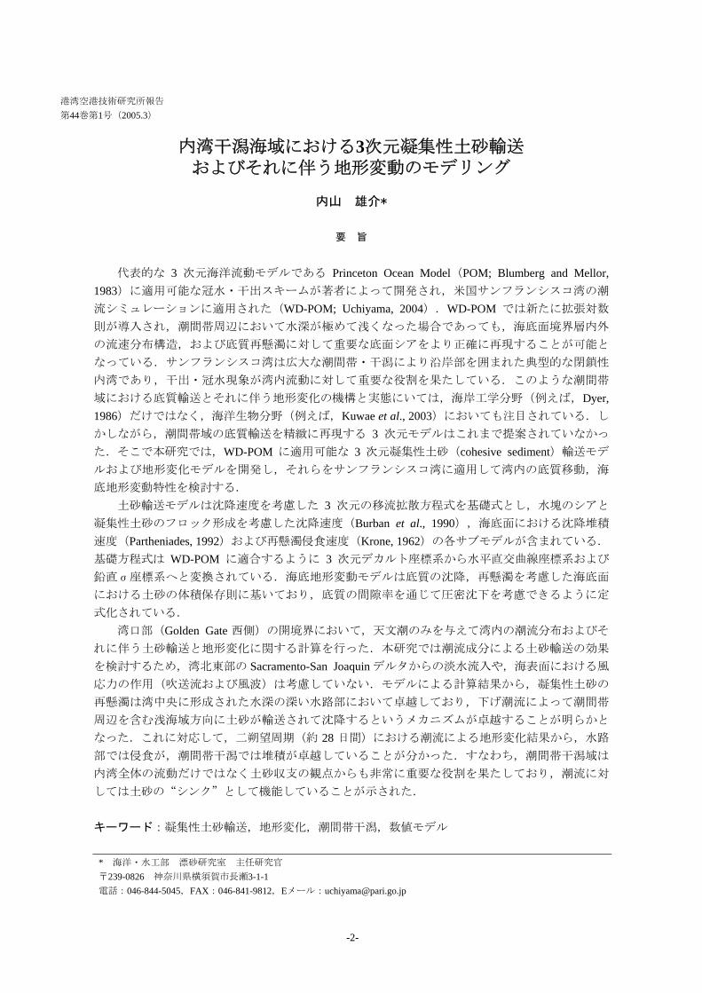

Modeling three-dimensional cohesive sediment transport and associated morphological response in estuarine intertidal mudflats
1 INTRODUCTION
Intertidal mudflats play a crucial role in the transport of land-sourced sediments and contaminants into estuar-ies Currents and waves interact to erode mudflats and vary with tidal range seasons and episodic events such as storms Sedimentation occurs during relatively calm periods when accretion is higher than erosion (Christie and Dyer 1998 Uchiyama et al 2001 Talke and Sta-cey 2003) Mudflats are recognized to be an important component of the estuarine system particularly with re-gard to sediments contaminants and organic matter be-cause they provide an extensive boundary condition (Dyer 1998) Hydrodynamics sediment transport and associated morphological variations have been investi-gated mostly through field measurement programs par-ticularly during the late 1990rsquos (eg Wood et al 1998 Whitehouse and Mitchener 1998 Widdows et al 1998 Li and Parchure 1998 Van der Lee 1998 Van der Lee 2000 Whitehouse et al 2000) Intertidal sediment transport and associated topography changes are of in-terest not only for coastal engineers and physical ocean-ographers (eg Dyer 1986) but also aquatic biochemists and marine biologists (eg Kerner 1993 de Jonge and van Beusekom 1995 Asmus et al 1998 Kuwae et al 1998 Cabrita and Brotas 2000 Christensen et al 2000 Kuwae et al 2003)
Effort has also been made to develop numerical mod-els for intertidal areas while wetting and drying (emer-gence during high waters and immergence during low waters) are essential to the intertidal hydrodynamics but it is generally difficult to implement the wettingdrying capability into three-dimensional numerical models Nevertheless a number of cohesive sediment transport models have been developed involving Sheng and Lick (1979) Thomas and McAnally (1985) Zeigler and Lick (1988) Hayter and Pakala (1989) Barros and Baptista (1989) Lee et al (1994) Ziegler and Nisbet (1994 1995) McDonald and Cheng (1997) Shrestha et al (2000) Inagaki (2000) HydroQual Inc (2002) Naka-gawa (2003 2005) Bricker et al (2004) and others Most of them are based on 2DH hydrodynamic models such as TRIM (Cheng et al 1993) which can readily be applied to intertidal simulations (McDonald and Cheng
1997) However intertidal mudflats extend in the estu-aries where baroclinic motion is effectively significant for the hydrodynamics (Ralston and Stacey 2004) and thus three-dimensional prognostic models are requisite for exploring intertidal sediment transport Among the models referred to above Inagaki (2000) Nakagawa (2003 2005) and Bricker et al (2004) developed the three-dimensional intertidal cohesive sediment transport models Inagaki (2000) and Bricker et al (2004) used a model based upon TRIM-3D (Casulli and Cattani 1994 Gross et al 1998) which is originally capable of simu-lating inundation and drainage occurred on intertidal mudflats However both of them paid no attention to intertidal processes whereas the simulations are done for South San Francisco Bay which is fringed by extensive intertidal areas and man-made salt ponds (Siegel and Bachand 2002) Nakagawa (2003 2005) employed the PHRI siltation model developed by Tsuruya et al (1990) with implementing a wetting and drying capability to simulate cohesive sediment transport in Ariake Bay Ja-pan still he mentioned nothing about effects of the inter-tidal mudflats surrounding the estuary on its hydrody-namics and sediment transport
A wetting and drying scheme (WDS) has recently been developed and incorporated into the Princeton Ocean Model (POM Blumberg and Mellor 1983 1987) to simulate tidal currents in San Francisco Bay (WD-POM Uchiyama 2004) The WDS is different from the other schemes proposed by Zheng et al (2003) Xie et al (2004) and Oey (2005) in representation of bed boundary layer since the extended logarithmic law was newly introduced into the WDS so as to accurately esti-mate bed shear stresses and resultant sediment resuspen-sion and deposition in extremely shallow basins such as intertidal mudflats The accuracy of WD-POM was verified by comparing the observed tidal surface eleva-tions and 3D current velocities to the model outputs The primary advantage of WD-POM over TRIM-3D and the PHRI model is its ability to evaluate the 3D hydro-dynamics and associated scalar (salinity temperature sediments etc) transport even though water depth ap-proaches zero in response to tide This is mainly due to the coordinate systems that these models employ Al-though TRIM-3D and the PHRI model are configured on
-5-
Yusuke UCHIYAMA
Figure 1 Location of the st marks correspond to the turb
the 3D Cartesian coordinate level vertical coordinate (wheparallel to a certain datum plaoriginal version of POM) is ovilinear coordinate with thesigma-coordinate (Uchiyamaconclusion of the study by USan Francisco Bay the intertremarkably alter and control bayment since the intertidal ently enhances refraction antidal waves while attenuatinconsequent phases owing to inshallow regions
The objectives of the presesive sediment transport andvariations to incorporate theexamine effects of intertidal tdrodynamics and resultant seCohesive sediments are intrichydrodynamics pore water and bioturbation as reviewed
udy San Francisco Bay amp Sacramento-San Joaquin Delta system California USA Circleidity measurement sites by Buchanan and Ruhl (2001) summarized in Table 3
with a so-called the multi-re vertical grids are aligned ne) WD-POM (and also its n the 2DH orthogonal cur- vertical terrain-following 2004) The important chiyama (2004) is that in
idal mudflats are found to hydrodynamics of the em-sloping bathymetry appar-d shoaling of propagating g propagating speeds and creasing bed friction in the
nt paper are to model cohe- associated morphological m into WD-POM and to opography on estuarine hy-diment transport processes ately influenced by ambient dynamics biostabilization in Black et al (2002) To
avoid this complexity the model presented here simply formulated by using the standard parameterizations such as by Krone (1962) for the resuspension rate by Parthe-niades (1992) for the deposition rate and by Burban et al (1990) for the settling speeds Attempts are made to extract some crucial properties of sedimentary dynamics from the computational results by paying careful atten-tion to effects of the intertidal shallow topography 2 STUDY SITE
San Francisco Bay California USA (Figures 1 and 2) consisting of South Bay Central Bay San Pablo Bay and Suisun Bay is chosen for the study site The bay is a tidally-forced semi-enclosed estuary encompassed by wide-spreading intertidal area comprising mudflats and salt marshes where flooding and draining are predomi-nant for overlaying hydrodynamics San Francisco Bay has the surface area of about 1240km2 and the intertidal mudflats of about 200km2 The Sacramento-San Joa-quin delta system enormously supplies the freshwater and associated sediment influx sourced by the Sierra
-6-
Modeling three-dimensional cohesive sediment transport and associated morphological response in estuarine intertidal mudflats
MtBtsd1b(2aWsem 3 3
1Ml
Figure 2 The bathymetric map of San Francisco Bay California USA (left) and the computational grid alignment us-ing the horizontal orthogonal curvilinear transformation (right) The bathymetry is relative to the MLLW level
ountains and Central Valley to the northeastern part of he bay ie Suisun Bay San Pablo Bay and Central ay (Conomos et al 1985) By contrast South Bay
he southernmost part of San Francisco Bay is often de-cribed as a tidally oscillating lagoon with density-riven exchanges with the northern reach (Gross et al 999) Limited number of numerical simulations have een performed for San Francisco Bay by Cheng et al 1993) and McDonald and Cheng (1997) using TRIM-D by Gross et al (1998) Inagaki (2000) and Bricker et l (2004) with TRIM-3D and by Uchiyama (2004) with D-POM since emersion and immersion are indispen-
able to hydrodynamics of the embayment although gen-rally laborious to incorporate into 3D hydrodynamic odels
NUMERICAL MODELING
1 Cohesive Sediment Transport
Princeton Ocean Model (Blumberg and Mellor 1983 987) consists of a set of the 3D primitive equations ellor-Yamada level 25 turbulent closure model (Mel-
or and Yamada 1982 Galperin et al 1988) for vertical
eddy coefficients and a Smagorinsky-type parameteriza-tion for horizontal mixing with the Boussinesq approxi-mation and hydrostatic assumption The governing equations are converted from the 3D Cartesian coordi-nate into the orthogonal curvilinear coordinate (horizon-tal) and σminuscoordinate (vertical) to smoothly follow com-plex terrain geometries and marine bathymetries as shown in Figure 2 A wetting and drying feature is implemented by Uchiyama (2004) to deal with hydrody-namics in extremely shallow basins composed of inter-tidal flats and salt marshes The cohesive sediment transport model to be coupled with WD-POM is devel-oped here as expressed in Eqn (1)
( )
CH
s
FCD
K
CWy
VCDx
UCDt
CD
+⎥⎦⎤
⎢⎣⎡
partpart
partpart
=
partpart
+part
part+
partpart
+part
part
σσ
σω -
(1)
where (U V ω) 3D velocity vector D total depth (=H+η H depth η surface elevation) C cohesive sediment concentration Ws settling velocity KH verti-cal eddy diffusivity and FC the horizontal diffusion terms Equation (1) is converted from the regular Car-tesian coordinate into the 2D horizontal curvilinear and
-7-
Yusuke UCHIYAMA
Table 1 Summary of the hydrodynamic and numerical parameters used in the San Francisco Bay-simulation
definition parameter value time step for external mode (2D) ∆te 5 s time step for internal mode (3D) ∆ti 50 s Smagorinsly constant AM 02 density of seawater ρ 1025 kgm3
roughness height z0 1 cm critical depth used in WDS dcr 20 cm minimum depth used in WDS dmin 5 cm scaling factor used in WDS δ 1 cm
( see Uchiyama 2004)
Table 2 Sedimentological parameters used in the San Francisco Bay-simulation
definition parameter value initial sediment concentration C|t=0 0 mgl roughness height for sediments zb 05 cm dry density of sediments ρs 20 kgm3
porosity of sediments λs 05 minimum τb for erosion τbe 015 Pa minimum τb for deposition τbd 003 Pa constant erosion probability Pe 5times10-6 kgm2s
vertical sigma coordinate as used in WD-POM Set-tling velocity Ws is unchanged in Eqn (1) after the con-version into a σ-coordinate system (Wang 2001 2002) The horizontal advection terms (the second ant third terms in the left hand side) are calculated with the Smo-larkiewiczrsquos iterative upstream scheme (Smolarkiewicz 1984) All the terms in Eqn (1) are solved explicitly except the vertical diffusion term 32 Boundary Conditions and Empirical Sub-models
The boundary conditions for Eqn (1) at the surface and seabed are defined as
00 rarr=⎟⎠⎞
⎜⎝⎛
partpart σσC
DKH at sea surface (2)
1 minusrarrminus=⎟⎠⎞
⎜⎝⎛
partpart σσ pr
H DECD
K at seabed (3)
where Er Dp erosion and deposition rates at the seabed empirically formulated The source term Er is sim-plistically evaluated to represent resuspension of cohe-sive sediments from the bed in accordance with the con-ventional formulation using the threshold stress τbe for
the bed shear stress τb and a constant erosion probability Pe (Krone 1962 Ariathurai and Krone 1976)
⎪⎩
⎪⎨
⎧
lt=
ge⎟⎟⎠
⎞⎜⎜⎝
⎛ minus=
bebr
bebbe
beber
whenE
whenPE
ττ
τττ
ττ
0
(4)
where Pe the constant erosion probability τbe the criti-cal bottom shear stress for erosion Similarly the sink term Dp in Eqn (3) can be calculated by using the parameterization by Partheniades (1992)
dsp PCWD = (51)
02
20
211 ωπ
ω
dePY
d int infinminus
minusminus= (52)
⎥⎦
⎤⎢⎣
⎡⎟⎟⎠
⎞⎜⎜⎝
⎛minussdot= sdot bdeY
bd
b τ
ττ 2711250log042 (53)
where Pd the deposition probability ω 0 a dummy vari-able and τbd the bottom shear stress below which Pd=1 (dynecm2)
Settling velocity Ws of cohesive flocs is calculated with the parameterization by Burban et al (1990) in
-8-
Modeling three-dimensional cohesive sediment transport and associated morphological response in estuarine intertidal mudflats
which flocculation is dependent on the product of local concentration and vertical shear stress in water column
( )βα CGWs = (61)
2122
zz ⎥⎥⎦
⎤
⎢⎢⎣
⎡⎟⎠⎞
⎜⎝⎛
partpart
+⎟⎠⎞
⎜⎝⎛
partpart
=VUKG Msρ (62)
in which ρs dry density of suspended medium KM ver-tical eddy viscosity α β the empirical non-dimensional constants Ws C and G are expressed in mday mgL and dynecm2 respectively The above equation im-plicitly incorporates the effect of internal shear stress G on aggregation and settling For saltwater suspensions Burban et al (1990) estimated values of α and β to be 242 and 022 (HydroQual Inc 2002) 33 Bed Shear Stress and Vertical Mixing Parameterization
Bed shear stress for sediments is formulated with slightly being modified based on the extended logarith-mic law to be
bbdsb uuC rrρτ = (71)
2
0ln1minus
⎥⎦
⎤⎢⎣
⎡⎟⎟⎠
⎞⎜⎜⎝
⎛ +=
bd z
zzCκ
(72)
where κ the von Karman constant Cd bed friction coef-ficient ub the bottom-most horizontal velocity vector z+ z0 height of ub relative to the bed z0 the roughness height and zb the roughness height for sediments To-gether with Eqn (7) leaving the determination of l un-changed where l is turbulent macroscale KM and the vertical eddy diffusivities KH and Kq must be slightly al-tered as proposed in Uchiyama (2004) so that
( )(( ) ⎪
⎭
⎪⎬
⎫
+=+=+=
0
0
0
zlqSKzlqSKzlqSK
HH
MM
κκκ
) (8)
where SM SH and Sq are the stability functions and q is the square root of TKE multiplied by 2 used in the Mel-lor-Yamada level 25 sub-model in POM
34 Bed Elevation Modeling
Bathymetry changes can be evaluated from the vol-ume conservation of sediments at the bed varying with erosion and deposition rates computed in the model
( ) (9) pr
ss
b DEtdhd
minus=ρλ
1
where hb bed elevation λs porosity of the bed sedi-ments Although the previous studies have often intro-duced a ldquolayeredrdquo bed model (Hayter 1983 McDonald and Cheng 1997 HydroQual Inc 2002) to incorporate consolidation of deposited sediments and vertical distri-bution of the dry density of sediments in the bed and the critical shear stress into the numerical models (Tsai and Lick 1987 MacIntyre et al 1990) it contains many unknown tuning parameters In the present study the bed elevation model is simplistically formulated to avoid intricate uncertainty 4 RESULTS 41 Cohesive Sediment Concentrations
The horizontal grid alignment of San Francisco Bay is displayed in Figure 2 A total of 45 x 160 horizontal cells and 10 vertical σ-layers are defined in the simula-tion as used by Uchiyama (2004) Astronomical tidal oscillations are imposed on the open boundary condition off Golden Gate (the bay mouth) Neither fluvial sedi-ments nor surface wind stresses are assumed in the com-putation for the simplicity The elevation condition is applied to the open boundary a spatial gradient (the first order differentiation) of elevation velocities q2 q2l and C are set to be zero The hydrodynamic sedimen-tological and numerical parameters used in the simula-tion are listed in Tables 1 and 2 The sedimentological parameters employed here are generally standard values not calibrated with field data since the simulation solely considers tidal currents so it would have almost no meaning to compare with the observed data quantita-tively Nevertheless the computed spatial distribution of sediment concentrations and morphological variations indicate a fairly reasonable agreement with the observed results as demonstrated later
-9-
Yusuke UCHIYAMA
Msdl
Figure 3 Bihourly evolution of the cohesive sediment concentrations (black-white colors) and 3D horizontal velocityvectors (white arrows) at the first σ-layer (surface) during a ebbing phase in a spring tide on the 108th and 109th Julianday in 2003 (UTC) The contour intervals are set to be 50mgl
The starting date of the simulation coincides with arch 29 2003 (the 88th Julian day in 2003) and a
imulation spin-up (McDonald and Cheng 1997) is con-ucted for the first 12 days to attain a dynamically equi-ibrium distribution of the sediment concentrations since
the simulation starts with zero concentration in the whole domain at t=0s The last 28 days (ie two spring-neap cycles) are utilized in the following analysis and thus the total duration of the computation is 40 days Water surface elevations and 3D tidal current velocities at mul-
-10-
Modeling three-dimensional cohesive sediment transport and associated morphological response in estuarine intertidal mudflats
Figure 4 Same as Figure 3 but during a flooding phase
tiple locations along the coast line of San Francisco Bay have already validated with the observed data to repre-sent that WD-POM is able to accurately reproduce the hydrodynamics in the whole bay (Uchiyama 2004)
Figures 3 and 4 show the bihourly development of the sediment concentrations and the 3D horizontal cur-rent velocity vectors at the first σ-layer for 14 hours on the 108th to 109th Julian day in 2003 in UTC The model outputs exhibit that during a spring tide cohesive
-11-
Yusuke UCHIYAMA
Table 3 Statistical summary of the near-bottom suspended sediment concentrations measured in San Francisco Bay ob-served by USGS (Buchanan and Ruhl 2001) The locations of the measurement sites are plotted in Figure 1 The concentrations are measured by optical backscatterance sensors (OBSs) calibrated with sampled turbid waters
Site mean (mgl) median (mgl) Mallard Island 46 58 Carquinez Bridge 203 297 Mare Island Causeway 186 235 Channel Marker 9 213 263 Point San Pablo 81 99 Pier 24 33 38 Channel Marker 17 171 215 Dumbarton Bridge 150 190 San Mateo Bridge 60 73
mid-depth concentration
sediments are suspended dominantly in the deeper chan-nels while being transported and deposited on the inter-tidal areas fringing the bay at flooding phases This tendency can also be observed during neap tides although magnitude of the variations is much smaller (not shown here) than those for the spring tides In South San Francisco Bay the concentrations are not as high as those in San Pablo Bay as weaker tidal currents are generated in South Bay The sediment concentra-tions in San Pablo Bay are estimated from the simulation to range from 0 to 300 mgl while those in South Bay vary about 0-200 mgl These ranges of the fluctuations reasonably agree with the observed data as listed in Ta-ble 3 and displayed in Figure 5 The measured con-centrations range from 0 to 150 mgl in the whole bay indicating higher concentrations in San Pablo Bay and Suisun Bay while lower in South Bay The median concentrations fluctuate from 99 (Point San Pablo) to 297 mgl (Carquinez Bridge) in San Pablo Bay although in South Bay ranging from 38 (Pier 24 Central Bay) to 215 mgl (Channel Marker 17 South Bay) as indicated in Table 3 (after Buchanan and Ruhl 2001) In addi-tion to the in situ measurements the satellite image analysis gave us the instantaneous surface sediment con-centrations as displayed in Figure 5 (after Ruhl et al 2001) The image was taken on March 25 1995 at 1300 and the concentrations are inferred from the bands-1 and -2 of the NOAA-14 AVHRR and calibrated with the measured data using optical backscatterance sensors These observed results clearly support that the
model presented here is capable of realistically reproduc-ing the cohesive sediment concentrations in San Fran-cisco Bay However because the concentrations may significantly increase in response to riverine discharges and wind condition it is necessary to implement these effects into the model in the future
The incoming tidal waves are propagating as anti-clockwise Kelvin waves but significantly refracted on the intertidal slopes in San Francisco Bay (Uchiyama 2004) presumably to boost the instantaneous as well as residual velocity component normal to the isobaths par-ticularly in the intertidal areas Figures 3 and 4 also exhibit that in San Pablo Bay the bed cohesive sediments begin to be resuspended in the channels during an ebbing phase (at 14h) and subsequently being carried in the di-rection of ebb tidal currents (at 16h through 18h) Next the resuspended sediments appear to be transported onto the intertidal areas in response to the rising tides and to approach the shoreline during floods (at 18h through 22h) and finally the sediments are diluted perhaps by deposition (at 22h though 2h) Figure 5 shows a simi-lar pattern in which higher concentrations appear to be around the deeper channels although lower on the inter-tidal shallow areas This spatial distribution of the sediment concentrations is most likely induced by the tidal current component normal to the isobaths and may provoke specific topography variation in the bay as dis-cussed later
-12-
Modeling three-dimensional cohesive sediment transport and associated morphological response in estuarine intertidal mudflats
Figure 5 A NOAA-AVHRR image corresponding to the instantaneous sediment concentrations in San Francisco Bayon March 25 1995 at 1300h (after Ruhl et al 2001)
42 Geomorphological Variations
The morphological changes due to the tidal currents during two spring-neap cycles (28 days) in San Pablo Bay and South Bay are estimated as shown in Figure 6 Intertidal mudflats tend to slightly be accreted whereas deeper channels seem rather eroded in the both subem-bayments This result is obviously consistent with the temporal development of the cohesive sediment concen-trations as sequently indicated in Figures 3 and 4 Sediment resuspension is predominant in the deeper channels to generate suspended cohesive sediments re-sulting in significant erosion The sediments are then transported and deposited onto the intertidal areas to en-hance accretion
This computed geomorphological pattern is next compared with surveyed topography variations Figure 7 (a) shows the bathymetry-change rate in San Pablo Bay calculated with the historical bathymetry surveys conducted by COOPS-NOS-NOAA in 1922 and 1951 and summarized by USGS (after Jaffe et al 1998)
The channel is eroded by about 24m for 29 years be-tween two surveys to yield ~10cmy as shown in Figure 7 (a) The simulated maximum erosion rate is about 10-20 cmy demonstrating the model can qualitatively replicate the geomorphological behavior in San Pablo Bay realistically This consistency also suggests that the sediment transport and associated bathymetry varia-tions are largely controlled by tidal currents However the locations of the most accretive regions inferred by the model outputs are slightly different from those by the surveys probably because the model neglects the surface wind stress waves and fluvial discharges and employs the simplified sediment submodels Similar compari-son can be done by examining Figures 6 (b) and 7 (b) which exhibits bathymetry changes between 1931 and 1956 in South Bay on the basis of the surveys (after Foxgrover et al 2004) The bathymetry tends to vary at around plusmn2-3cmy in the simulated results although about plusmn1-2cmy calculated from the surveys The model-generated morphological pattern is much different from that evaluated by the surveys Accretion pre-
-13-
Yusuke UCHIYAMA
(a) San Pablo Bay ndash Central San Francisco Bay (b) South San Francisco Bay
Figure 6 Model-estimated bathymetry changes in (a) San Pablo Bay and (b) South San Francisco Bay
(a) San Pablo Bay ndash Central San Francisco Bay (b) South San Francisco Bay
Figure 7 The erosion and accretion rate estimated for the historical bathymetric surveys conducted by CO-OPS NOS-NOAA in (a) San Pablo Bay (after Jaffe et al 1998) and (b) South San Francisco Bay (after Foxgroverl et al 2004)
dominantly occurs in the whole South Bay according to the surveyed results while the model output shows that the intertidal areas are largely eroded This inconsis-tency may also be caused by the neglecting hydrody-namic components such as wind and waves which gen-erally enhance erosion
5 DISCUSSION
The model is qualitatively able to estimate the cohe-sive sediment transport and resultant bathymetry varia-tions with having a realistic agreement with the observed
-14-
Modeling three-dimensional cohesive sediment transport and associated morphological response in estuarine intertidal mudflats
Figure 8 Long-term accretion on an intertidal sloping topography Only a sinusoidal tidal oscillation is considered at the open boundary (the left side)
results An important finding here is that the tidal cur-rents have a key role in the sediment resuspension and the subembayment or inter-embayment scale dispersion of the resuspended sediments to induce erosion in the deeper channels and accretion in the intertidal areas In order to verify this accretive effect of tidal currents on intertidal topography a 2D-vertical long-term simulation of sediment transport and morphological response on a uniform intertidal slope is performed The initial beach slope is set at 1500 and monochromatic sinusoidal tidal oscillations with amplitude of 12m and at a period of 12h are imposed on the open boundary condition located at the cross-shore distance of 0km in Figure 8 The sedimentological parameters and the other boundary conditions are same as those used in the 3D simulation for San Francisco Bay except the open boundary condi-tion for the sediment concentration In the 2D simula-tion a constant value of C0 (C0 is set 100 mgl here) is used for the sediment concentrations when the direction of currents at the open boundary is landward The nu-merical parameters are set here as ∆ te = 2s ∆ ti = 60s ∆ x = 100m 5 vertical σ-layers are used and the Coriolis terms are eliminated
The computed long-term morphological evolution is found to be similar to the results of the 3D simulation The flooding tides evidently amplify the shoreward sediment transport to be deposited near the shoreline and accordingly enhance the accretion in the intertidal areas As a consequent the intertidal topography is de-veloped gradually near the high water mark The cross-shore topography after 100 years is resemble the results
with more simplified 1D models proposed by Roberts et al (2000) and Pritchard et al (2002) This result also suggests that tidal currents evidently influence to raise the sediment deposition on the intertidal areas and to create the flat topography near the shoreline 6 CONCLUSIONS
Cohesive sediment transport and resultant bathymetry response in estuaries encompassed by intertidal area are developed on the basis of WD-POM The primary ad-vantage of the model is its ability to simulate the vertical hydrodynamics (vertical profiles of 3D velocities turbu-lence sediments and other passive scalars) even though the water surface descends to become extremely shallow The model employs the widely-used parameterizations involving the erosion rate submodel by Krone (1962) the deposition rate submodel by Partheniades (1992) and the settling speed submodel by Burban et al (1990)
The model is applied to San Francisco Bay CA USA which is fringed by extensive intertidal mudflats The model outputs are compared to the observed results by Buchanan and Ruhl (2001) Ruhl et al (2001) Jaffe et al (1998) and Foxgrover et al (2004) to exhibit a reasonable agreement The simulated results indicate that the sediments are remarkably suspended in the deeper channels while deposited on the intertidal fringes This sediment transport induces significant erosion in the channel and visible accretion in the intertidal mudflats The intertidal areas play an important role in the sedi-ment budgets in the estuary acting as lsquosinkrsquo of the sus-
-15-
Yusuke UCHIYAMA
pended cohesive sediments under action of the tidal cur-rents A supplemental 2D vertical simulation with a simplified numerical setting also supports the results educed from the 3D simulation to demonstrate that tidal currents have evident influence on transporting the re-suspended sediment shoreward and enhancing accumula-tion to create mudflat topographies ACKNOWLEDGEMENTS
This research project was partially supported by Ja-pan Society for Promotion of Science and is a part of the authorrsquos work during his stay at University of California Berkeley USA since March 2002 till March 2004 The author would like to express sincere appreciation to Professor Mark T Stacey of UC Berkeley Professor Rodney J Sobey of Imperial College of London UK and Mr Yasuyuki Nakagawa of Port and Airport Re-search Institute Japan for their helpful comments on the manuscript Thanks are also due to Mr Satoshi Inagaki of Kajima Corporation Dr Jeremy D Bricker of Kobe University Dr Stefan A Talke and Dr David K Ral-ston of UC Berkeley for their discussion on the numeri-cal modeling and help with searching for the literatures
(Accepted on November 10 2004) REFERENCES Ariathurai R and Krone RB 1976 Mathematical
modeling of sediment transport in estuaries Circula-tion Sediments and Transfer of Material in the Estu-ary Wiley ML (ed) Estuarine Processes 11 Aca-demic Press New York USA 98-106
Asmus RM Jensen MH Jensen KM Kristensen E Asmus H and Wille A 1998 The role of water movement and spatial scaling for measurement of dis-solved inorganic nitrogen fluxes in intertidal sedi-ments Estuar Coast Shelf Sci 46 221-232
Barros AP and Baptista AM 1989 An Eulerian-Lagrangian model for sediment transport in estuaries In Estuarine and Coastal Modeling M Spaulding (ed) ASCE 1 102-112
Black KS Tolhurst TJ Paterson DM and Hager-they SE 2002 Working with natural cohesive sediments J Hydr Eng 128 2-8
Blumberg AF and Mellor GL 1983 Diagnostic and prognostic numerical circulation studies of the South Atlantic Bight J Geophys Res 88 4579-4593
Blumberg AF and Mellor GL 1987 A description of a three-dimensional coastal ocean circulation model In Three-dimensional Coastal Ocean Models Vol4 Heaps N (ed) Ameri Geophys Union Washington DC pp208
Bricker JD Inagaki S and Monismith SG 2004 Modeling the effects of bed drag coefficient variabil-ity under wind waves in South San Francisco Bay Proc 8th Intrsquol Conf Coastal and Estuarine Modeling ASCE Monterey CA USA (in print Pers Comm)
Buchanan PA and Ruhl CA 2001 Summary of sus-pended-sediment concentration data San Francisco Bay California Water Year 1999 Open-File Report 01-100 US Geological Survey Sacramento CA USA 40pp
Burban PY Xu Y McNeil J and Lick W 1990 Settling speeds of flocs in fresh and sea waters J Geophys Res 95 18213-18220
Cabrita MT and Brotas V 2000 Seasonal variation in denitrification and dissolved nitrogen fluxes in inter-tidal sediments of Tagus estuary Portugal Mar Ecol Progress Ser 202 51-65
Casulli V and Cattani E 1994 Stability accuracy and efficiency of a semi-implicit method for three-dimensional shallow water flow Computers and Mathematics with Application 27 99-112
Cheng RT Casulli V and Gartner JW 1993 Tidal residual intertidal mudflat (TRIM) model and its ap-plication to San Francisco Bay California Estuar Coastal Shelf Sci 36 235-280
Christensen B Vedel A and Kristensen E 2000 Carbon and nitrogen fluxes in sediment inhabited by suspension-feeding (Nereis diversicolor) and non-suspension feeding (N Virens) polychaetes Mar Ecol Progress Ser 192 203-217
Christie MC and Dyer KR 1998 Measurements of the turbid tidal edge over Skeffling mudflats In Black KS Patterson DM and Cramp A (eds) Sedimentary processes in the intertidal zone Geo-logical Society London UK 139 45-55
-16-
Modeling three-dimensional cohesive sediment transport and associated morphological response in estuarine intertidal mudflats
Conomos TJ Smith RE and Gartner JW 1985 En-vironmental setting of San Francisco Bay Hydrobi-ologia 129 1-12
De Jonge VN and van Beusekom JEE 1995 Wind- and tide-induced resuspension of sediment and mi-crophytobenthos from tidal flats in the Ems estuary Limnol Oceanogr 40 766-778
Dyer KR 1986 Intertidal areas In Coastal and Es-tuarine Sediment Dynamics John Wiley amp Sons Ltd Chichester UK 260-264
Dyer KR 1998 The typology of intertidal mudflats In Black KS Patterson DM and Cramp A (eds) Sedimentary processes in the intertidal zone Geo-logical Society London UK 139 11-24
Foxgrover AC Higgins SA Ingraca MK Jaffe BE and Smith RE 2004 Deposition Erosion and Bathymetric Change in South San Francisco Bay 1858 ndash 1983 Open-File Report 2004-1192 US Geo-logical Survey Santa Cruz CA USA 23pp
Galperin B Kantha LH Hassid S and Rosati A 1988 A quasi-equilibrium turbulent energy model for geophysical flows J Atmos Sci 45 55-62
Gross ES Koseff JR and Monismith SG 1999 Three-dimensional salinity simulations of South San Francisco Bay J Hydraulic Eng 125 1199-1209
Hayter EJ 1983 Prediction of cohesive sediment movement in estuarial waters PhD thesis Univer-sity of Florida Gainesville FL USA 363pp
Hayter EJ and Pakala CV 1989 Transport of inor-ganic contaminants in estuarial waters J Coastal Res 5 217-230
HydroQual Inc 2002 A primer for ECOMSED Users Manual Ver 13 HydroQual Inc Mahwah NJ USA 188pp
Inagaki S 2000 Effects of a proposed San Francisco airport runway extension on hydrodynamics and sediment transport in South San Francisco Bay En-gineerrsquos Degree Thesis Stanford University Stan-ford CA USA
Jaffe BE Smith RE and Torresan LZ 1998 Sedi-mentation and Bathymetric Change in San Pablo Bay 1856ndash1983 Open-File Report 98-759 US Geologi-cal Survey Menlo Park CA USA
Kerner M 1993 Coupling of microbial fermentation and respiration processes in an intertidal mudflat of the Elbe estuary Limnol Oceanogr 38 314-330
Krone RB 1962 Flume study of the transport of sediment in estuarial processes Final Report Hy-draulic Eng Lab and Sanitary Eng Res Lab Univ Calif Berkeley CA USA
Kuwae T Hosokawa Y and Eguchi N 1998 Dis-solved inorganic nitrogen cycling in Banzu intertidal sand-flat Japan Mangroves and Salt Marshes 2 167-175
Kuwae T Kibe E and Nakamura Y 2003 Effect of emersion and immersion on the porewater nutrient dynamics of an intertidal sandflat in Tokyo Bay Estu Coastal Shelf Sci 57 929-940
Lee DH Bedford KW and Yen CJ 1994 Storm and entrainment effects on tributary sediment loads J Hydr Eng 120 81-103
Li Y and Parchure TM 1998 Mudbanks of the southwest coast of India VI Suspended sediment profiles J Coastal Res 14 (4) 1363-1372
MacIntyre S Lick W and Tsai CH 1990 Variability of entrainment of cohesive sediments in freshwater Biogeochemistry 9 187-209
McDonald ET and Cheng RT 1997 A numerical model of sediment transport applied to San Francisco Bay California J Marine Env Eng 4 1-41
Mellor GL and Yamada T 1982 Development of a turbulence closure model for geophysical fluid prob-lems Rev Geophys Space Phys 20 851-875
Nakagawa Y 2003 Numerical modeling of fine sedi-ment transport processes in the Ariake Bay Rep Port and Airport Res Inst Port and Airport Res Inst Yokosuka Japan Vol42 (4) 25-42 (in Japanese with an English abstract)
Nakagawa Y 2005 Fine sediment transport in Ariake Bay Japan Proc INTERCOH 2003 (in print Pers Comm)
Oey L-Y 2005 A wetting and drying scheme for POM Ocean Modeling 8 (in press Pers Comm)
Partheniades E 1992 Estuarine sediment dynamics and shoaling processes In Herbick J (ed) Handbook of Coastal and Ocean Engineering 3 985-1071
Pritchard D Hogg AJ and Roberts W 2002 Mor-phological modelling of intertidal mudflats the role
-17-
Yusuke UCHIYAMA
of cross-shore tidal currents Cont Shelf Res 22 1887-1895
Ralston DK and Stacey MT 2004 Three-dimensional modeling of intertidal flow and transport Periodic stratification and its implications for sedi-ment transport Suppl AGU Chapman Conf Salt-marsh Geomorphology Amer Geophys Union Hali-fax NS Canada 27-28
Roberts W Le Hir P and Whitehouse RJS 2000 Investigation using simple mathematical models of the effect of tidal currents and waves on the profile shape of intertidal mudflats Cont Shelf Res 20 1079-1097
Ruhl CA Schoelhammer DH Stumpf RP and Lindsay CL 2001 Combined use of remote sensing and continuous monitoring to analyse the variability of suspended sediment concentrations in San Fran-cisco Bay California Estur Coastal Shelf Sci 53 801-812
Sheng YP and Lick W 1979 The transport and re-suspension of sediments in a shallow lake J Geo-phys Res 84 (C4) 1809-1826
Shrestha PL Blumberg AF Di Toro DM and Hell-weger F 2000 A three-dimensional model for cohe-sive sediment transport in shallow bays ASCE Joint Conf Water Resour Eng and Water Resour Plan-ning and Management Minneapolis MN USA
Siegel SW and Bachand PAM 2002 Feasibility analysis South Bay Salt Pond Restoration Wetlands and Water Resources San Rafael CA USA 228 pp
Smolarkiewicz PK 1984 A fully multidimensional positive definite advection transport algorithm with small implicit diffusion J Comp Phys 54 325-362
Tsai CH and Lick W 1987 Resuspension of sedi-ments from Long Island Sound Wat Sci Tech 21 (6-7) 155-184
Talke SA and Stacey MT 2003 The influence of oceanic swell on flows over an estuarine intertidal mudflat in San Francisco Bay Estuar Coastal Shelf Sci 58 541-554
Thomas WA and McAnally WHJr 1985 Userrsquos manual for the generalized computer program system open-channel flow and sedimentation TABS-2 In-struction Report HL85-1 US Army Engineer Water-ways Experimental Station Vicksburg MS USA
Tsuruya K Murakami K and Irie K 1990 Mathe-matical modeling of mud transport in ports with a multilayer model ndash Application to Kumamoto Port- Rep Port and Harbour Res Inst Port and Harbour Res Inst Yokosuka Japan Vol29 (1) 3-51
Uchiyama Y Kuriyama Y and Katoh K 2001 Sus-pended sediment and morphological response on Banzu tidal flat Japan Proc4th Intrsquol Conf Coastal Dynamics Ameri Soc Civil Eng Lund Sweden 1038-1047
Uchiyama Y 2004 Modeling wetting and drying scheme based on an extended logarithmic law for a three-dimensional sigma-coordinate coastal ocean model Rep Port and Airport Res Inst Port and Air-port Res Inst Yokosuka Japan 43 (4) 3-21
Van der Lee WTB 1998 The impact of fluid shear and the suspended sediment concentration on the mud floc size variation in the Dollard estuary The Nether-lands In Black KS Patterson DM and Cramp A (eds) Sedimentary processes in the intertidal zone Geological Society London UK 139 187-198
Van der Lee WTB 2000 Temporal variation of floc size and settling velocity in the Dollard estuary Con-tinental Shelf Res 20 1495 ndash 1511
Wang XH 2001 A numerical study of sediment trans-port in a coastal embayment during winter storms J Coastal Res 34 414-427
Wang XH 2002 Tide-induced sediment resuspension and the bottom boundary layer in an idealized estuary with a muddy bed J Phys Oceanogr 32 3113-3131
WhitehouseRJS and Mitchener HJ 1998 Observa-tions of the morphodynamic behavior of an intertidal mudflat at different timescales In Black KS Pat-terson DM and Cramp A (eds) Sedimentary proc-esses in the intertidal zone Geological Society Lon-don UK 139 255-271
Whitehouse RJS Soulsby RL Roberts W and MitchenerHJ 2000 Intertidal Processes In Dy-namics of estuarine muds Thomas Telford London UK 163-168
Widdows J Brinsley M and Elliott M 1998 Use of in-situ flume to quantify particle flux (biodeposition rates and sediment erosion) for an intertidal mudflat in relation to changes in current velocity and benthic
-18-
Modeling three-dimensional cohesive sediment transport and associated morphological response in estuarine intertidal mudflats
Zheng L Chen C and Liu H 2003 A modeling study of the Satilla River Estuary Georgia I Flooding-drying process and water exchange over the salt marsh-estuary-shelf complex Estuaries 26 (3) 651-669
macrofauna In Black KS Patterson DM and Cramp A (eds) Sedimentary processes in the inter-tidal zone Geological Society London UK 139 85-97
Wood RG Black KS and Jago CF 1998 Meas-urements of preliminary modeling of current velocity over an intertidal mudflat In Black KS Patterson DM and Cramp A (eds) Sedimentary processes in the intertidal zone Geological Society London UK 139 167-175
Ziegler CK and Lick W 1988 The transport of fine-grained sediments in shallow waters Env Geol Water Sci 11 (1) 123-132
Ziegler CK and Nisbet BS 1994 Fine-grained sedi-ment transport in Pawtuxet River Rhode Island J Hydr Eng 120 (5) 561-576 Xie L Pietrafesa LJ and Peng M 2004 Incorpora-
tion of a mass-conserving inundation scheme into a three dimensional storm surge model J Coastal Res 20 282-296
Ziegler CK and Nisbet BS 1995 Long-term simula-tion of fine-grained sediment transport in large reser-vior J Hydr Eng 121 (11) 773-781
-19-
Yusuke UCHIYAMA
Figure 1 Location of the st marks correspond to the turb
the 3D Cartesian coordinate level vertical coordinate (wheparallel to a certain datum plaoriginal version of POM) is ovilinear coordinate with thesigma-coordinate (Uchiyamaconclusion of the study by USan Francisco Bay the intertremarkably alter and control bayment since the intertidal ently enhances refraction antidal waves while attenuatinconsequent phases owing to inshallow regions
The objectives of the presesive sediment transport andvariations to incorporate theexamine effects of intertidal tdrodynamics and resultant seCohesive sediments are intrichydrodynamics pore water and bioturbation as reviewed
udy San Francisco Bay amp Sacramento-San Joaquin Delta system California USA Circleidity measurement sites by Buchanan and Ruhl (2001) summarized in Table 3
with a so-called the multi-re vertical grids are aligned ne) WD-POM (and also its n the 2DH orthogonal cur- vertical terrain-following 2004) The important chiyama (2004) is that in
idal mudflats are found to hydrodynamics of the em-sloping bathymetry appar-d shoaling of propagating g propagating speeds and creasing bed friction in the
nt paper are to model cohe- associated morphological m into WD-POM and to opography on estuarine hy-diment transport processes ately influenced by ambient dynamics biostabilization in Black et al (2002) To
avoid this complexity the model presented here simply formulated by using the standard parameterizations such as by Krone (1962) for the resuspension rate by Parthe-niades (1992) for the deposition rate and by Burban et al (1990) for the settling speeds Attempts are made to extract some crucial properties of sedimentary dynamics from the computational results by paying careful atten-tion to effects of the intertidal shallow topography 2 STUDY SITE
San Francisco Bay California USA (Figures 1 and 2) consisting of South Bay Central Bay San Pablo Bay and Suisun Bay is chosen for the study site The bay is a tidally-forced semi-enclosed estuary encompassed by wide-spreading intertidal area comprising mudflats and salt marshes where flooding and draining are predomi-nant for overlaying hydrodynamics San Francisco Bay has the surface area of about 1240km2 and the intertidal mudflats of about 200km2 The Sacramento-San Joa-quin delta system enormously supplies the freshwater and associated sediment influx sourced by the Sierra
-6-
Modeling three-dimensional cohesive sediment transport and associated morphological response in estuarine intertidal mudflats
MtBtsd1b(2aWsem 3 3
1Ml
Figure 2 The bathymetric map of San Francisco Bay California USA (left) and the computational grid alignment us-ing the horizontal orthogonal curvilinear transformation (right) The bathymetry is relative to the MLLW level
ountains and Central Valley to the northeastern part of he bay ie Suisun Bay San Pablo Bay and Central ay (Conomos et al 1985) By contrast South Bay
he southernmost part of San Francisco Bay is often de-cribed as a tidally oscillating lagoon with density-riven exchanges with the northern reach (Gross et al 999) Limited number of numerical simulations have een performed for San Francisco Bay by Cheng et al 1993) and McDonald and Cheng (1997) using TRIM-D by Gross et al (1998) Inagaki (2000) and Bricker et l (2004) with TRIM-3D and by Uchiyama (2004) with D-POM since emersion and immersion are indispen-
able to hydrodynamics of the embayment although gen-rally laborious to incorporate into 3D hydrodynamic odels
NUMERICAL MODELING
1 Cohesive Sediment Transport
Princeton Ocean Model (Blumberg and Mellor 1983 987) consists of a set of the 3D primitive equations ellor-Yamada level 25 turbulent closure model (Mel-
or and Yamada 1982 Galperin et al 1988) for vertical
eddy coefficients and a Smagorinsky-type parameteriza-tion for horizontal mixing with the Boussinesq approxi-mation and hydrostatic assumption The governing equations are converted from the 3D Cartesian coordi-nate into the orthogonal curvilinear coordinate (horizon-tal) and σminuscoordinate (vertical) to smoothly follow com-plex terrain geometries and marine bathymetries as shown in Figure 2 A wetting and drying feature is implemented by Uchiyama (2004) to deal with hydrody-namics in extremely shallow basins composed of inter-tidal flats and salt marshes The cohesive sediment transport model to be coupled with WD-POM is devel-oped here as expressed in Eqn (1)
( )
CH
s
FCD
K
CWy
VCDx
UCDt
CD
+⎥⎦⎤
⎢⎣⎡
partpart
partpart
=
partpart
+part
part+
partpart
+part
part
σσ
σω -
(1)
where (U V ω) 3D velocity vector D total depth (=H+η H depth η surface elevation) C cohesive sediment concentration Ws settling velocity KH verti-cal eddy diffusivity and FC the horizontal diffusion terms Equation (1) is converted from the regular Car-tesian coordinate into the 2D horizontal curvilinear and
-7-
Yusuke UCHIYAMA
Table 1 Summary of the hydrodynamic and numerical parameters used in the San Francisco Bay-simulation
definition parameter value time step for external mode (2D) ∆te 5 s time step for internal mode (3D) ∆ti 50 s Smagorinsly constant AM 02 density of seawater ρ 1025 kgm3
roughness height z0 1 cm critical depth used in WDS dcr 20 cm minimum depth used in WDS dmin 5 cm scaling factor used in WDS δ 1 cm
( see Uchiyama 2004)
Table 2 Sedimentological parameters used in the San Francisco Bay-simulation
definition parameter value initial sediment concentration C|t=0 0 mgl roughness height for sediments zb 05 cm dry density of sediments ρs 20 kgm3
porosity of sediments λs 05 minimum τb for erosion τbe 015 Pa minimum τb for deposition τbd 003 Pa constant erosion probability Pe 5times10-6 kgm2s
vertical sigma coordinate as used in WD-POM Set-tling velocity Ws is unchanged in Eqn (1) after the con-version into a σ-coordinate system (Wang 2001 2002) The horizontal advection terms (the second ant third terms in the left hand side) are calculated with the Smo-larkiewiczrsquos iterative upstream scheme (Smolarkiewicz 1984) All the terms in Eqn (1) are solved explicitly except the vertical diffusion term 32 Boundary Conditions and Empirical Sub-models
The boundary conditions for Eqn (1) at the surface and seabed are defined as
00 rarr=⎟⎠⎞
⎜⎝⎛
partpart σσC
DKH at sea surface (2)
1 minusrarrminus=⎟⎠⎞
⎜⎝⎛
partpart σσ pr
H DECD
K at seabed (3)
where Er Dp erosion and deposition rates at the seabed empirically formulated The source term Er is sim-plistically evaluated to represent resuspension of cohe-sive sediments from the bed in accordance with the con-ventional formulation using the threshold stress τbe for
the bed shear stress τb and a constant erosion probability Pe (Krone 1962 Ariathurai and Krone 1976)
⎪⎩
⎪⎨
⎧
lt=
ge⎟⎟⎠
⎞⎜⎜⎝
⎛ minus=
bebr
bebbe
beber
whenE
whenPE
ττ
τττ
ττ
0
(4)
where Pe the constant erosion probability τbe the criti-cal bottom shear stress for erosion Similarly the sink term Dp in Eqn (3) can be calculated by using the parameterization by Partheniades (1992)
dsp PCWD = (51)
02
20
211 ωπ
ω
dePY
d int infinminus
minusminus= (52)
⎥⎦
⎤⎢⎣
⎡⎟⎟⎠
⎞⎜⎜⎝
⎛minussdot= sdot bdeY
bd
b τ
ττ 2711250log042 (53)
where Pd the deposition probability ω 0 a dummy vari-able and τbd the bottom shear stress below which Pd=1 (dynecm2)
Settling velocity Ws of cohesive flocs is calculated with the parameterization by Burban et al (1990) in
-8-
Modeling three-dimensional cohesive sediment transport and associated morphological response in estuarine intertidal mudflats
which flocculation is dependent on the product of local concentration and vertical shear stress in water column
( )βα CGWs = (61)
2122
zz ⎥⎥⎦
⎤
⎢⎢⎣
⎡⎟⎠⎞
⎜⎝⎛
partpart
+⎟⎠⎞
⎜⎝⎛
partpart
=VUKG Msρ (62)
in which ρs dry density of suspended medium KM ver-tical eddy viscosity α β the empirical non-dimensional constants Ws C and G are expressed in mday mgL and dynecm2 respectively The above equation im-plicitly incorporates the effect of internal shear stress G on aggregation and settling For saltwater suspensions Burban et al (1990) estimated values of α and β to be 242 and 022 (HydroQual Inc 2002) 33 Bed Shear Stress and Vertical Mixing Parameterization
Bed shear stress for sediments is formulated with slightly being modified based on the extended logarith-mic law to be
bbdsb uuC rrρτ = (71)
2
0ln1minus
⎥⎦
⎤⎢⎣
⎡⎟⎟⎠
⎞⎜⎜⎝
⎛ +=
bd z
zzCκ
(72)
where κ the von Karman constant Cd bed friction coef-ficient ub the bottom-most horizontal velocity vector z+ z0 height of ub relative to the bed z0 the roughness height and zb the roughness height for sediments To-gether with Eqn (7) leaving the determination of l un-changed where l is turbulent macroscale KM and the vertical eddy diffusivities KH and Kq must be slightly al-tered as proposed in Uchiyama (2004) so that
( )(( ) ⎪
⎭
⎪⎬
⎫
+=+=+=
0
0
0
zlqSKzlqSKzlqSK
HH
MM
κκκ
) (8)
where SM SH and Sq are the stability functions and q is the square root of TKE multiplied by 2 used in the Mel-lor-Yamada level 25 sub-model in POM
34 Bed Elevation Modeling
Bathymetry changes can be evaluated from the vol-ume conservation of sediments at the bed varying with erosion and deposition rates computed in the model
( ) (9) pr
ss
b DEtdhd
minus=ρλ
1
where hb bed elevation λs porosity of the bed sedi-ments Although the previous studies have often intro-duced a ldquolayeredrdquo bed model (Hayter 1983 McDonald and Cheng 1997 HydroQual Inc 2002) to incorporate consolidation of deposited sediments and vertical distri-bution of the dry density of sediments in the bed and the critical shear stress into the numerical models (Tsai and Lick 1987 MacIntyre et al 1990) it contains many unknown tuning parameters In the present study the bed elevation model is simplistically formulated to avoid intricate uncertainty 4 RESULTS 41 Cohesive Sediment Concentrations
The horizontal grid alignment of San Francisco Bay is displayed in Figure 2 A total of 45 x 160 horizontal cells and 10 vertical σ-layers are defined in the simula-tion as used by Uchiyama (2004) Astronomical tidal oscillations are imposed on the open boundary condition off Golden Gate (the bay mouth) Neither fluvial sedi-ments nor surface wind stresses are assumed in the com-putation for the simplicity The elevation condition is applied to the open boundary a spatial gradient (the first order differentiation) of elevation velocities q2 q2l and C are set to be zero The hydrodynamic sedimen-tological and numerical parameters used in the simula-tion are listed in Tables 1 and 2 The sedimentological parameters employed here are generally standard values not calibrated with field data since the simulation solely considers tidal currents so it would have almost no meaning to compare with the observed data quantita-tively Nevertheless the computed spatial distribution of sediment concentrations and morphological variations indicate a fairly reasonable agreement with the observed results as demonstrated later
-9-
Yusuke UCHIYAMA
Msdl
Figure 3 Bihourly evolution of the cohesive sediment concentrations (black-white colors) and 3D horizontal velocityvectors (white arrows) at the first σ-layer (surface) during a ebbing phase in a spring tide on the 108th and 109th Julianday in 2003 (UTC) The contour intervals are set to be 50mgl
The starting date of the simulation coincides with arch 29 2003 (the 88th Julian day in 2003) and a
imulation spin-up (McDonald and Cheng 1997) is con-ucted for the first 12 days to attain a dynamically equi-ibrium distribution of the sediment concentrations since
the simulation starts with zero concentration in the whole domain at t=0s The last 28 days (ie two spring-neap cycles) are utilized in the following analysis and thus the total duration of the computation is 40 days Water surface elevations and 3D tidal current velocities at mul-
-10-
Modeling three-dimensional cohesive sediment transport and associated morphological response in estuarine intertidal mudflats
Figure 4 Same as Figure 3 but during a flooding phase
tiple locations along the coast line of San Francisco Bay have already validated with the observed data to repre-sent that WD-POM is able to accurately reproduce the hydrodynamics in the whole bay (Uchiyama 2004)
Figures 3 and 4 show the bihourly development of the sediment concentrations and the 3D horizontal cur-rent velocity vectors at the first σ-layer for 14 hours on the 108th to 109th Julian day in 2003 in UTC The model outputs exhibit that during a spring tide cohesive
-11-
Yusuke UCHIYAMA
Table 3 Statistical summary of the near-bottom suspended sediment concentrations measured in San Francisco Bay ob-served by USGS (Buchanan and Ruhl 2001) The locations of the measurement sites are plotted in Figure 1 The concentrations are measured by optical backscatterance sensors (OBSs) calibrated with sampled turbid waters
Site mean (mgl) median (mgl) Mallard Island 46 58 Carquinez Bridge 203 297 Mare Island Causeway 186 235 Channel Marker 9 213 263 Point San Pablo 81 99 Pier 24 33 38 Channel Marker 17 171 215 Dumbarton Bridge 150 190 San Mateo Bridge 60 73
mid-depth concentration
sediments are suspended dominantly in the deeper chan-nels while being transported and deposited on the inter-tidal areas fringing the bay at flooding phases This tendency can also be observed during neap tides although magnitude of the variations is much smaller (not shown here) than those for the spring tides In South San Francisco Bay the concentrations are not as high as those in San Pablo Bay as weaker tidal currents are generated in South Bay The sediment concentra-tions in San Pablo Bay are estimated from the simulation to range from 0 to 300 mgl while those in South Bay vary about 0-200 mgl These ranges of the fluctuations reasonably agree with the observed data as listed in Ta-ble 3 and displayed in Figure 5 The measured con-centrations range from 0 to 150 mgl in the whole bay indicating higher concentrations in San Pablo Bay and Suisun Bay while lower in South Bay The median concentrations fluctuate from 99 (Point San Pablo) to 297 mgl (Carquinez Bridge) in San Pablo Bay although in South Bay ranging from 38 (Pier 24 Central Bay) to 215 mgl (Channel Marker 17 South Bay) as indicated in Table 3 (after Buchanan and Ruhl 2001) In addi-tion to the in situ measurements the satellite image analysis gave us the instantaneous surface sediment con-centrations as displayed in Figure 5 (after Ruhl et al 2001) The image was taken on March 25 1995 at 1300 and the concentrations are inferred from the bands-1 and -2 of the NOAA-14 AVHRR and calibrated with the measured data using optical backscatterance sensors These observed results clearly support that the
model presented here is capable of realistically reproduc-ing the cohesive sediment concentrations in San Fran-cisco Bay However because the concentrations may significantly increase in response to riverine discharges and wind condition it is necessary to implement these effects into the model in the future
The incoming tidal waves are propagating as anti-clockwise Kelvin waves but significantly refracted on the intertidal slopes in San Francisco Bay (Uchiyama 2004) presumably to boost the instantaneous as well as residual velocity component normal to the isobaths par-ticularly in the intertidal areas Figures 3 and 4 also exhibit that in San Pablo Bay the bed cohesive sediments begin to be resuspended in the channels during an ebbing phase (at 14h) and subsequently being carried in the di-rection of ebb tidal currents (at 16h through 18h) Next the resuspended sediments appear to be transported onto the intertidal areas in response to the rising tides and to approach the shoreline during floods (at 18h through 22h) and finally the sediments are diluted perhaps by deposition (at 22h though 2h) Figure 5 shows a simi-lar pattern in which higher concentrations appear to be around the deeper channels although lower on the inter-tidal shallow areas This spatial distribution of the sediment concentrations is most likely induced by the tidal current component normal to the isobaths and may provoke specific topography variation in the bay as dis-cussed later
-12-
Modeling three-dimensional cohesive sediment transport and associated morphological response in estuarine intertidal mudflats
Figure 5 A NOAA-AVHRR image corresponding to the instantaneous sediment concentrations in San Francisco Bayon March 25 1995 at 1300h (after Ruhl et al 2001)
42 Geomorphological Variations
The morphological changes due to the tidal currents during two spring-neap cycles (28 days) in San Pablo Bay and South Bay are estimated as shown in Figure 6 Intertidal mudflats tend to slightly be accreted whereas deeper channels seem rather eroded in the both subem-bayments This result is obviously consistent with the temporal development of the cohesive sediment concen-trations as sequently indicated in Figures 3 and 4 Sediment resuspension is predominant in the deeper channels to generate suspended cohesive sediments re-sulting in significant erosion The sediments are then transported and deposited onto the intertidal areas to en-hance accretion
This computed geomorphological pattern is next compared with surveyed topography variations Figure 7 (a) shows the bathymetry-change rate in San Pablo Bay calculated with the historical bathymetry surveys conducted by COOPS-NOS-NOAA in 1922 and 1951 and summarized by USGS (after Jaffe et al 1998)
The channel is eroded by about 24m for 29 years be-tween two surveys to yield ~10cmy as shown in Figure 7 (a) The simulated maximum erosion rate is about 10-20 cmy demonstrating the model can qualitatively replicate the geomorphological behavior in San Pablo Bay realistically This consistency also suggests that the sediment transport and associated bathymetry varia-tions are largely controlled by tidal currents However the locations of the most accretive regions inferred by the model outputs are slightly different from those by the surveys probably because the model neglects the surface wind stress waves and fluvial discharges and employs the simplified sediment submodels Similar compari-son can be done by examining Figures 6 (b) and 7 (b) which exhibits bathymetry changes between 1931 and 1956 in South Bay on the basis of the surveys (after Foxgrover et al 2004) The bathymetry tends to vary at around plusmn2-3cmy in the simulated results although about plusmn1-2cmy calculated from the surveys The model-generated morphological pattern is much different from that evaluated by the surveys Accretion pre-
-13-
Yusuke UCHIYAMA
(a) San Pablo Bay ndash Central San Francisco Bay (b) South San Francisco Bay
Figure 6 Model-estimated bathymetry changes in (a) San Pablo Bay and (b) South San Francisco Bay
(a) San Pablo Bay ndash Central San Francisco Bay (b) South San Francisco Bay
Figure 7 The erosion and accretion rate estimated for the historical bathymetric surveys conducted by CO-OPS NOS-NOAA in (a) San Pablo Bay (after Jaffe et al 1998) and (b) South San Francisco Bay (after Foxgroverl et al 2004)
dominantly occurs in the whole South Bay according to the surveyed results while the model output shows that the intertidal areas are largely eroded This inconsis-tency may also be caused by the neglecting hydrody-namic components such as wind and waves which gen-erally enhance erosion
5 DISCUSSION
The model is qualitatively able to estimate the cohe-sive sediment transport and resultant bathymetry varia-tions with having a realistic agreement with the observed
-14-
Modeling three-dimensional cohesive sediment transport and associated morphological response in estuarine intertidal mudflats
Figure 8 Long-term accretion on an intertidal sloping topography Only a sinusoidal tidal oscillation is considered at the open boundary (the left side)
results An important finding here is that the tidal cur-rents have a key role in the sediment resuspension and the subembayment or inter-embayment scale dispersion of the resuspended sediments to induce erosion in the deeper channels and accretion in the intertidal areas In order to verify this accretive effect of tidal currents on intertidal topography a 2D-vertical long-term simulation of sediment transport and morphological response on a uniform intertidal slope is performed The initial beach slope is set at 1500 and monochromatic sinusoidal tidal oscillations with amplitude of 12m and at a period of 12h are imposed on the open boundary condition located at the cross-shore distance of 0km in Figure 8 The sedimentological parameters and the other boundary conditions are same as those used in the 3D simulation for San Francisco Bay except the open boundary condi-tion for the sediment concentration In the 2D simula-tion a constant value of C0 (C0 is set 100 mgl here) is used for the sediment concentrations when the direction of currents at the open boundary is landward The nu-merical parameters are set here as ∆ te = 2s ∆ ti = 60s ∆ x = 100m 5 vertical σ-layers are used and the Coriolis terms are eliminated
The computed long-term morphological evolution is found to be similar to the results of the 3D simulation The flooding tides evidently amplify the shoreward sediment transport to be deposited near the shoreline and accordingly enhance the accretion in the intertidal areas As a consequent the intertidal topography is de-veloped gradually near the high water mark The cross-shore topography after 100 years is resemble the results
with more simplified 1D models proposed by Roberts et al (2000) and Pritchard et al (2002) This result also suggests that tidal currents evidently influence to raise the sediment deposition on the intertidal areas and to create the flat topography near the shoreline 6 CONCLUSIONS
Cohesive sediment transport and resultant bathymetry response in estuaries encompassed by intertidal area are developed on the basis of WD-POM The primary ad-vantage of the model is its ability to simulate the vertical hydrodynamics (vertical profiles of 3D velocities turbu-lence sediments and other passive scalars) even though the water surface descends to become extremely shallow The model employs the widely-used parameterizations involving the erosion rate submodel by Krone (1962) the deposition rate submodel by Partheniades (1992) and the settling speed submodel by Burban et al (1990)
The model is applied to San Francisco Bay CA USA which is fringed by extensive intertidal mudflats The model outputs are compared to the observed results by Buchanan and Ruhl (2001) Ruhl et al (2001) Jaffe et al (1998) and Foxgrover et al (2004) to exhibit a reasonable agreement The simulated results indicate that the sediments are remarkably suspended in the deeper channels while deposited on the intertidal fringes This sediment transport induces significant erosion in the channel and visible accretion in the intertidal mudflats The intertidal areas play an important role in the sedi-ment budgets in the estuary acting as lsquosinkrsquo of the sus-
-15-
Yusuke UCHIYAMA
pended cohesive sediments under action of the tidal cur-rents A supplemental 2D vertical simulation with a simplified numerical setting also supports the results educed from the 3D simulation to demonstrate that tidal currents have evident influence on transporting the re-suspended sediment shoreward and enhancing accumula-tion to create mudflat topographies ACKNOWLEDGEMENTS
This research project was partially supported by Ja-pan Society for Promotion of Science and is a part of the authorrsquos work during his stay at University of California Berkeley USA since March 2002 till March 2004 The author would like to express sincere appreciation to Professor Mark T Stacey of UC Berkeley Professor Rodney J Sobey of Imperial College of London UK and Mr Yasuyuki Nakagawa of Port and Airport Re-search Institute Japan for their helpful comments on the manuscript Thanks are also due to Mr Satoshi Inagaki of Kajima Corporation Dr Jeremy D Bricker of Kobe University Dr Stefan A Talke and Dr David K Ral-ston of UC Berkeley for their discussion on the numeri-cal modeling and help with searching for the literatures
(Accepted on November 10 2004) REFERENCES Ariathurai R and Krone RB 1976 Mathematical
modeling of sediment transport in estuaries Circula-tion Sediments and Transfer of Material in the Estu-ary Wiley ML (ed) Estuarine Processes 11 Aca-demic Press New York USA 98-106
Asmus RM Jensen MH Jensen KM Kristensen E Asmus H and Wille A 1998 The role of water movement and spatial scaling for measurement of dis-solved inorganic nitrogen fluxes in intertidal sedi-ments Estuar Coast Shelf Sci 46 221-232
Barros AP and Baptista AM 1989 An Eulerian-Lagrangian model for sediment transport in estuaries In Estuarine and Coastal Modeling M Spaulding (ed) ASCE 1 102-112
Black KS Tolhurst TJ Paterson DM and Hager-they SE 2002 Working with natural cohesive sediments J Hydr Eng 128 2-8
Blumberg AF and Mellor GL 1983 Diagnostic and prognostic numerical circulation studies of the South Atlantic Bight J Geophys Res 88 4579-4593
Blumberg AF and Mellor GL 1987 A description of a three-dimensional coastal ocean circulation model In Three-dimensional Coastal Ocean Models Vol4 Heaps N (ed) Ameri Geophys Union Washington DC pp208
Bricker JD Inagaki S and Monismith SG 2004 Modeling the effects of bed drag coefficient variabil-ity under wind waves in South San Francisco Bay Proc 8th Intrsquol Conf Coastal and Estuarine Modeling ASCE Monterey CA USA (in print Pers Comm)
Buchanan PA and Ruhl CA 2001 Summary of sus-pended-sediment concentration data San Francisco Bay California Water Year 1999 Open-File Report 01-100 US Geological Survey Sacramento CA USA 40pp
Burban PY Xu Y McNeil J and Lick W 1990 Settling speeds of flocs in fresh and sea waters J Geophys Res 95 18213-18220
Cabrita MT and Brotas V 2000 Seasonal variation in denitrification and dissolved nitrogen fluxes in inter-tidal sediments of Tagus estuary Portugal Mar Ecol Progress Ser 202 51-65
Casulli V and Cattani E 1994 Stability accuracy and efficiency of a semi-implicit method for three-dimensional shallow water flow Computers and Mathematics with Application 27 99-112
Cheng RT Casulli V and Gartner JW 1993 Tidal residual intertidal mudflat (TRIM) model and its ap-plication to San Francisco Bay California Estuar Coastal Shelf Sci 36 235-280
Christensen B Vedel A and Kristensen E 2000 Carbon and nitrogen fluxes in sediment inhabited by suspension-feeding (Nereis diversicolor) and non-suspension feeding (N Virens) polychaetes Mar Ecol Progress Ser 192 203-217
Christie MC and Dyer KR 1998 Measurements of the turbid tidal edge over Skeffling mudflats In Black KS Patterson DM and Cramp A (eds) Sedimentary processes in the intertidal zone Geo-logical Society London UK 139 45-55
-16-
Modeling three-dimensional cohesive sediment transport and associated morphological response in estuarine intertidal mudflats
Conomos TJ Smith RE and Gartner JW 1985 En-vironmental setting of San Francisco Bay Hydrobi-ologia 129 1-12
De Jonge VN and van Beusekom JEE 1995 Wind- and tide-induced resuspension of sediment and mi-crophytobenthos from tidal flats in the Ems estuary Limnol Oceanogr 40 766-778
Dyer KR 1986 Intertidal areas In Coastal and Es-tuarine Sediment Dynamics John Wiley amp Sons Ltd Chichester UK 260-264
Dyer KR 1998 The typology of intertidal mudflats In Black KS Patterson DM and Cramp A (eds) Sedimentary processes in the intertidal zone Geo-logical Society London UK 139 11-24
Foxgrover AC Higgins SA Ingraca MK Jaffe BE and Smith RE 2004 Deposition Erosion and Bathymetric Change in South San Francisco Bay 1858 ndash 1983 Open-File Report 2004-1192 US Geo-logical Survey Santa Cruz CA USA 23pp
Galperin B Kantha LH Hassid S and Rosati A 1988 A quasi-equilibrium turbulent energy model for geophysical flows J Atmos Sci 45 55-62
Gross ES Koseff JR and Monismith SG 1999 Three-dimensional salinity simulations of South San Francisco Bay J Hydraulic Eng 125 1199-1209
Hayter EJ 1983 Prediction of cohesive sediment movement in estuarial waters PhD thesis Univer-sity of Florida Gainesville FL USA 363pp
Hayter EJ and Pakala CV 1989 Transport of inor-ganic contaminants in estuarial waters J Coastal Res 5 217-230
HydroQual Inc 2002 A primer for ECOMSED Users Manual Ver 13 HydroQual Inc Mahwah NJ USA 188pp
Inagaki S 2000 Effects of a proposed San Francisco airport runway extension on hydrodynamics and sediment transport in South San Francisco Bay En-gineerrsquos Degree Thesis Stanford University Stan-ford CA USA
Jaffe BE Smith RE and Torresan LZ 1998 Sedi-mentation and Bathymetric Change in San Pablo Bay 1856ndash1983 Open-File Report 98-759 US Geologi-cal Survey Menlo Park CA USA
Kerner M 1993 Coupling of microbial fermentation and respiration processes in an intertidal mudflat of the Elbe estuary Limnol Oceanogr 38 314-330
Krone RB 1962 Flume study of the transport of sediment in estuarial processes Final Report Hy-draulic Eng Lab and Sanitary Eng Res Lab Univ Calif Berkeley CA USA
Kuwae T Hosokawa Y and Eguchi N 1998 Dis-solved inorganic nitrogen cycling in Banzu intertidal sand-flat Japan Mangroves and Salt Marshes 2 167-175
Kuwae T Kibe E and Nakamura Y 2003 Effect of emersion and immersion on the porewater nutrient dynamics of an intertidal sandflat in Tokyo Bay Estu Coastal Shelf Sci 57 929-940
Lee DH Bedford KW and Yen CJ 1994 Storm and entrainment effects on tributary sediment loads J Hydr Eng 120 81-103
Li Y and Parchure TM 1998 Mudbanks of the southwest coast of India VI Suspended sediment profiles J Coastal Res 14 (4) 1363-1372
MacIntyre S Lick W and Tsai CH 1990 Variability of entrainment of cohesive sediments in freshwater Biogeochemistry 9 187-209
McDonald ET and Cheng RT 1997 A numerical model of sediment transport applied to San Francisco Bay California J Marine Env Eng 4 1-41
Mellor GL and Yamada T 1982 Development of a turbulence closure model for geophysical fluid prob-lems Rev Geophys Space Phys 20 851-875
Nakagawa Y 2003 Numerical modeling of fine sedi-ment transport processes in the Ariake Bay Rep Port and Airport Res Inst Port and Airport Res Inst Yokosuka Japan Vol42 (4) 25-42 (in Japanese with an English abstract)
Nakagawa Y 2005 Fine sediment transport in Ariake Bay Japan Proc INTERCOH 2003 (in print Pers Comm)
Oey L-Y 2005 A wetting and drying scheme for POM Ocean Modeling 8 (in press Pers Comm)
Partheniades E 1992 Estuarine sediment dynamics and shoaling processes In Herbick J (ed) Handbook of Coastal and Ocean Engineering 3 985-1071
Pritchard D Hogg AJ and Roberts W 2002 Mor-phological modelling of intertidal mudflats the role
-17-
Yusuke UCHIYAMA
of cross-shore tidal currents Cont Shelf Res 22 1887-1895
Ralston DK and Stacey MT 2004 Three-dimensional modeling of intertidal flow and transport Periodic stratification and its implications for sedi-ment transport Suppl AGU Chapman Conf Salt-marsh Geomorphology Amer Geophys Union Hali-fax NS Canada 27-28
Roberts W Le Hir P and Whitehouse RJS 2000 Investigation using simple mathematical models of the effect of tidal currents and waves on the profile shape of intertidal mudflats Cont Shelf Res 20 1079-1097
Ruhl CA Schoelhammer DH Stumpf RP and Lindsay CL 2001 Combined use of remote sensing and continuous monitoring to analyse the variability of suspended sediment concentrations in San Fran-cisco Bay California Estur Coastal Shelf Sci 53 801-812
Sheng YP and Lick W 1979 The transport and re-suspension of sediments in a shallow lake J Geo-phys Res 84 (C4) 1809-1826
Shrestha PL Blumberg AF Di Toro DM and Hell-weger F 2000 A three-dimensional model for cohe-sive sediment transport in shallow bays ASCE Joint Conf Water Resour Eng and Water Resour Plan-ning and Management Minneapolis MN USA
Siegel SW and Bachand PAM 2002 Feasibility analysis South Bay Salt Pond Restoration Wetlands and Water Resources San Rafael CA USA 228 pp
Smolarkiewicz PK 1984 A fully multidimensional positive definite advection transport algorithm with small implicit diffusion J Comp Phys 54 325-362
Tsai CH and Lick W 1987 Resuspension of sedi-ments from Long Island Sound Wat Sci Tech 21 (6-7) 155-184
Talke SA and Stacey MT 2003 The influence of oceanic swell on flows over an estuarine intertidal mudflat in San Francisco Bay Estuar Coastal Shelf Sci 58 541-554
Thomas WA and McAnally WHJr 1985 Userrsquos manual for the generalized computer program system open-channel flow and sedimentation TABS-2 In-struction Report HL85-1 US Army Engineer Water-ways Experimental Station Vicksburg MS USA
Tsuruya K Murakami K and Irie K 1990 Mathe-matical modeling of mud transport in ports with a multilayer model ndash Application to Kumamoto Port- Rep Port and Harbour Res Inst Port and Harbour Res Inst Yokosuka Japan Vol29 (1) 3-51
Uchiyama Y Kuriyama Y and Katoh K 2001 Sus-pended sediment and morphological response on Banzu tidal flat Japan Proc4th Intrsquol Conf Coastal Dynamics Ameri Soc Civil Eng Lund Sweden 1038-1047
Uchiyama Y 2004 Modeling wetting and drying scheme based on an extended logarithmic law for a three-dimensional sigma-coordinate coastal ocean model Rep Port and Airport Res Inst Port and Air-port Res Inst Yokosuka Japan 43 (4) 3-21
Van der Lee WTB 1998 The impact of fluid shear and the suspended sediment concentration on the mud floc size variation in the Dollard estuary The Nether-lands In Black KS Patterson DM and Cramp A (eds) Sedimentary processes in the intertidal zone Geological Society London UK 139 187-198
Van der Lee WTB 2000 Temporal variation of floc size and settling velocity in the Dollard estuary Con-tinental Shelf Res 20 1495 ndash 1511
Wang XH 2001 A numerical study of sediment trans-port in a coastal embayment during winter storms J Coastal Res 34 414-427
Wang XH 2002 Tide-induced sediment resuspension and the bottom boundary layer in an idealized estuary with a muddy bed J Phys Oceanogr 32 3113-3131
WhitehouseRJS and Mitchener HJ 1998 Observa-tions of the morphodynamic behavior of an intertidal mudflat at different timescales In Black KS Pat-terson DM and Cramp A (eds) Sedimentary proc-esses in the intertidal zone Geological Society Lon-don UK 139 255-271
Whitehouse RJS Soulsby RL Roberts W and MitchenerHJ 2000 Intertidal Processes In Dy-namics of estuarine muds Thomas Telford London UK 163-168
Widdows J Brinsley M and Elliott M 1998 Use of in-situ flume to quantify particle flux (biodeposition rates and sediment erosion) for an intertidal mudflat in relation to changes in current velocity and benthic
-18-
Modeling three-dimensional cohesive sediment transport and associated morphological response in estuarine intertidal mudflats
Zheng L Chen C and Liu H 2003 A modeling study of the Satilla River Estuary Georgia I Flooding-drying process and water exchange over the salt marsh-estuary-shelf complex Estuaries 26 (3) 651-669
macrofauna In Black KS Patterson DM and Cramp A (eds) Sedimentary processes in the inter-tidal zone Geological Society London UK 139 85-97
Wood RG Black KS and Jago CF 1998 Meas-urements of preliminary modeling of current velocity over an intertidal mudflat In Black KS Patterson DM and Cramp A (eds) Sedimentary processes in the intertidal zone Geological Society London UK 139 167-175
Ziegler CK and Lick W 1988 The transport of fine-grained sediments in shallow waters Env Geol Water Sci 11 (1) 123-132
Ziegler CK and Nisbet BS 1994 Fine-grained sedi-ment transport in Pawtuxet River Rhode Island J Hydr Eng 120 (5) 561-576 Xie L Pietrafesa LJ and Peng M 2004 Incorpora-
tion of a mass-conserving inundation scheme into a three dimensional storm surge model J Coastal Res 20 282-296
Ziegler CK and Nisbet BS 1995 Long-term simula-tion of fine-grained sediment transport in large reser-vior J Hydr Eng 121 (11) 773-781
-19-

Modeling three-dimensional cohesive sediment transport and associated morphological response in estuarine intertidal mudflats
MtBtsd1b(2aWsem 3 3
1Ml
Figure 2 The bathymetric map of San Francisco Bay California USA (left) and the computational grid alignment us-ing the horizontal orthogonal curvilinear transformation (right) The bathymetry is relative to the MLLW level
ountains and Central Valley to the northeastern part of he bay ie Suisun Bay San Pablo Bay and Central ay (Conomos et al 1985) By contrast South Bay
he southernmost part of San Francisco Bay is often de-cribed as a tidally oscillating lagoon with density-riven exchanges with the northern reach (Gross et al 999) Limited number of numerical simulations have een performed for San Francisco Bay by Cheng et al 1993) and McDonald and Cheng (1997) using TRIM-D by Gross et al (1998) Inagaki (2000) and Bricker et l (2004) with TRIM-3D and by Uchiyama (2004) with D-POM since emersion and immersion are indispen-
able to hydrodynamics of the embayment although gen-rally laborious to incorporate into 3D hydrodynamic odels
NUMERICAL MODELING
1 Cohesive Sediment Transport
Princeton Ocean Model (Blumberg and Mellor 1983 987) consists of a set of the 3D primitive equations ellor-Yamada level 25 turbulent closure model (Mel-
or and Yamada 1982 Galperin et al 1988) for vertical
eddy coefficients and a Smagorinsky-type parameteriza-tion for horizontal mixing with the Boussinesq approxi-mation and hydrostatic assumption The governing equations are converted from the 3D Cartesian coordi-nate into the orthogonal curvilinear coordinate (horizon-tal) and σminuscoordinate (vertical) to smoothly follow com-plex terrain geometries and marine bathymetries as shown in Figure 2 A wetting and drying feature is implemented by Uchiyama (2004) to deal with hydrody-namics in extremely shallow basins composed of inter-tidal flats and salt marshes The cohesive sediment transport model to be coupled with WD-POM is devel-oped here as expressed in Eqn (1)
( )
CH
s
FCD
K
CWy
VCDx
UCDt
CD
+⎥⎦⎤
⎢⎣⎡
partpart
partpart
=
partpart
+part
part+
partpart
+part
part
σσ
σω -
(1)
where (U V ω) 3D velocity vector D total depth (=H+η H depth η surface elevation) C cohesive sediment concentration Ws settling velocity KH verti-cal eddy diffusivity and FC the horizontal diffusion terms Equation (1) is converted from the regular Car-tesian coordinate into the 2D horizontal curvilinear and
-7-
Yusuke UCHIYAMA
Table 1 Summary of the hydrodynamic and numerical parameters used in the San Francisco Bay-simulation
definition parameter value time step for external mode (2D) ∆te 5 s time step for internal mode (3D) ∆ti 50 s Smagorinsly constant AM 02 density of seawater ρ 1025 kgm3
roughness height z0 1 cm critical depth used in WDS dcr 20 cm minimum depth used in WDS dmin 5 cm scaling factor used in WDS δ 1 cm
( see Uchiyama 2004)
Table 2 Sedimentological parameters used in the San Francisco Bay-simulation
definition parameter value initial sediment concentration C|t=0 0 mgl roughness height for sediments zb 05 cm dry density of sediments ρs 20 kgm3
porosity of sediments λs 05 minimum τb for erosion τbe 015 Pa minimum τb for deposition τbd 003 Pa constant erosion probability Pe 5times10-6 kgm2s
vertical sigma coordinate as used in WD-POM Set-tling velocity Ws is unchanged in Eqn (1) after the con-version into a σ-coordinate system (Wang 2001 2002) The horizontal advection terms (the second ant third terms in the left hand side) are calculated with the Smo-larkiewiczrsquos iterative upstream scheme (Smolarkiewicz 1984) All the terms in Eqn (1) are solved explicitly except the vertical diffusion term 32 Boundary Conditions and Empirical Sub-models
The boundary conditions for Eqn (1) at the surface and seabed are defined as
00 rarr=⎟⎠⎞
⎜⎝⎛
partpart σσC
DKH at sea surface (2)
1 minusrarrminus=⎟⎠⎞
⎜⎝⎛
partpart σσ pr
H DECD
K at seabed (3)
where Er Dp erosion and deposition rates at the seabed empirically formulated The source term Er is sim-plistically evaluated to represent resuspension of cohe-sive sediments from the bed in accordance with the con-ventional formulation using the threshold stress τbe for
the bed shear stress τb and a constant erosion probability Pe (Krone 1962 Ariathurai and Krone 1976)
⎪⎩
⎪⎨
⎧
lt=
ge⎟⎟⎠
⎞⎜⎜⎝
⎛ minus=
bebr
bebbe
beber
whenE
whenPE
ττ
τττ
ττ
0
(4)
where Pe the constant erosion probability τbe the criti-cal bottom shear stress for erosion Similarly the sink term Dp in Eqn (3) can be calculated by using the parameterization by Partheniades (1992)
dsp PCWD = (51)
02
20
211 ωπ
ω
dePY
d int infinminus
minusminus= (52)
⎥⎦
⎤⎢⎣
⎡⎟⎟⎠
⎞⎜⎜⎝
⎛minussdot= sdot bdeY
bd
b τ
ττ 2711250log042 (53)
where Pd the deposition probability ω 0 a dummy vari-able and τbd the bottom shear stress below which Pd=1 (dynecm2)
Settling velocity Ws of cohesive flocs is calculated with the parameterization by Burban et al (1990) in
-8-
Modeling three-dimensional cohesive sediment transport and associated morphological response in estuarine intertidal mudflats
which flocculation is dependent on the product of local concentration and vertical shear stress in water column
( )βα CGWs = (61)
2122
zz ⎥⎥⎦
⎤
⎢⎢⎣
⎡⎟⎠⎞
⎜⎝⎛
partpart
+⎟⎠⎞
⎜⎝⎛
partpart
=VUKG Msρ (62)
in which ρs dry density of suspended medium KM ver-tical eddy viscosity α β the empirical non-dimensional constants Ws C and G are expressed in mday mgL and dynecm2 respectively The above equation im-plicitly incorporates the effect of internal shear stress G on aggregation and settling For saltwater suspensions Burban et al (1990) estimated values of α and β to be 242 and 022 (HydroQual Inc 2002) 33 Bed Shear Stress and Vertical Mixing Parameterization
Bed shear stress for sediments is formulated with slightly being modified based on the extended logarith-mic law to be
bbdsb uuC rrρτ = (71)
2
0ln1minus
⎥⎦
⎤⎢⎣
⎡⎟⎟⎠
⎞⎜⎜⎝
⎛ +=
bd z
zzCκ
(72)
where κ the von Karman constant Cd bed friction coef-ficient ub the bottom-most horizontal velocity vector z+ z0 height of ub relative to the bed z0 the roughness height and zb the roughness height for sediments To-gether with Eqn (7) leaving the determination of l un-changed where l is turbulent macroscale KM and the vertical eddy diffusivities KH and Kq must be slightly al-tered as proposed in Uchiyama (2004) so that
( )(( ) ⎪
⎭
⎪⎬
⎫
+=+=+=
0
0
0
zlqSKzlqSKzlqSK
HH
MM
κκκ
) (8)
where SM SH and Sq are the stability functions and q is the square root of TKE multiplied by 2 used in the Mel-lor-Yamada level 25 sub-model in POM
34 Bed Elevation Modeling
Bathymetry changes can be evaluated from the vol-ume conservation of sediments at the bed varying with erosion and deposition rates computed in the model
( ) (9) pr
ss
b DEtdhd
minus=ρλ
1
where hb bed elevation λs porosity of the bed sedi-ments Although the previous studies have often intro-duced a ldquolayeredrdquo bed model (Hayter 1983 McDonald and Cheng 1997 HydroQual Inc 2002) to incorporate consolidation of deposited sediments and vertical distri-bution of the dry density of sediments in the bed and the critical shear stress into the numerical models (Tsai and Lick 1987 MacIntyre et al 1990) it contains many unknown tuning parameters In the present study the bed elevation model is simplistically formulated to avoid intricate uncertainty 4 RESULTS 41 Cohesive Sediment Concentrations
The horizontal grid alignment of San Francisco Bay is displayed in Figure 2 A total of 45 x 160 horizontal cells and 10 vertical σ-layers are defined in the simula-tion as used by Uchiyama (2004) Astronomical tidal oscillations are imposed on the open boundary condition off Golden Gate (the bay mouth) Neither fluvial sedi-ments nor surface wind stresses are assumed in the com-putation for the simplicity The elevation condition is applied to the open boundary a spatial gradient (the first order differentiation) of elevation velocities q2 q2l and C are set to be zero The hydrodynamic sedimen-tological and numerical parameters used in the simula-tion are listed in Tables 1 and 2 The sedimentological parameters employed here are generally standard values not calibrated with field data since the simulation solely considers tidal currents so it would have almost no meaning to compare with the observed data quantita-tively Nevertheless the computed spatial distribution of sediment concentrations and morphological variations indicate a fairly reasonable agreement with the observed results as demonstrated later
-9-
Yusuke UCHIYAMA
Msdl
Figure 3 Bihourly evolution of the cohesive sediment concentrations (black-white colors) and 3D horizontal velocityvectors (white arrows) at the first σ-layer (surface) during a ebbing phase in a spring tide on the 108th and 109th Julianday in 2003 (UTC) The contour intervals are set to be 50mgl
The starting date of the simulation coincides with arch 29 2003 (the 88th Julian day in 2003) and a
imulation spin-up (McDonald and Cheng 1997) is con-ucted for the first 12 days to attain a dynamically equi-ibrium distribution of the sediment concentrations since
the simulation starts with zero concentration in the whole domain at t=0s The last 28 days (ie two spring-neap cycles) are utilized in the following analysis and thus the total duration of the computation is 40 days Water surface elevations and 3D tidal current velocities at mul-
-10-
Modeling three-dimensional cohesive sediment transport and associated morphological response in estuarine intertidal mudflats
Figure 4 Same as Figure 3 but during a flooding phase
tiple locations along the coast line of San Francisco Bay have already validated with the observed data to repre-sent that WD-POM is able to accurately reproduce the hydrodynamics in the whole bay (Uchiyama 2004)
Figures 3 and 4 show the bihourly development of the sediment concentrations and the 3D horizontal cur-rent velocity vectors at the first σ-layer for 14 hours on the 108th to 109th Julian day in 2003 in UTC The model outputs exhibit that during a spring tide cohesive
-11-
Yusuke UCHIYAMA
Table 3 Statistical summary of the near-bottom suspended sediment concentrations measured in San Francisco Bay ob-served by USGS (Buchanan and Ruhl 2001) The locations of the measurement sites are plotted in Figure 1 The concentrations are measured by optical backscatterance sensors (OBSs) calibrated with sampled turbid waters
Site mean (mgl) median (mgl) Mallard Island 46 58 Carquinez Bridge 203 297 Mare Island Causeway 186 235 Channel Marker 9 213 263 Point San Pablo 81 99 Pier 24 33 38 Channel Marker 17 171 215 Dumbarton Bridge 150 190 San Mateo Bridge 60 73
mid-depth concentration
sediments are suspended dominantly in the deeper chan-nels while being transported and deposited on the inter-tidal areas fringing the bay at flooding phases This tendency can also be observed during neap tides although magnitude of the variations is much smaller (not shown here) than those for the spring tides In South San Francisco Bay the concentrations are not as high as those in San Pablo Bay as weaker tidal currents are generated in South Bay The sediment concentra-tions in San Pablo Bay are estimated from the simulation to range from 0 to 300 mgl while those in South Bay vary about 0-200 mgl These ranges of the fluctuations reasonably agree with the observed data as listed in Ta-ble 3 and displayed in Figure 5 The measured con-centrations range from 0 to 150 mgl in the whole bay indicating higher concentrations in San Pablo Bay and Suisun Bay while lower in South Bay The median concentrations fluctuate from 99 (Point San Pablo) to 297 mgl (Carquinez Bridge) in San Pablo Bay although in South Bay ranging from 38 (Pier 24 Central Bay) to 215 mgl (Channel Marker 17 South Bay) as indicated in Table 3 (after Buchanan and Ruhl 2001) In addi-tion to the in situ measurements the satellite image analysis gave us the instantaneous surface sediment con-centrations as displayed in Figure 5 (after Ruhl et al 2001) The image was taken on March 25 1995 at 1300 and the concentrations are inferred from the bands-1 and -2 of the NOAA-14 AVHRR and calibrated with the measured data using optical backscatterance sensors These observed results clearly support that the
model presented here is capable of realistically reproduc-ing the cohesive sediment concentrations in San Fran-cisco Bay However because the concentrations may significantly increase in response to riverine discharges and wind condition it is necessary to implement these effects into the model in the future
The incoming tidal waves are propagating as anti-clockwise Kelvin waves but significantly refracted on the intertidal slopes in San Francisco Bay (Uchiyama 2004) presumably to boost the instantaneous as well as residual velocity component normal to the isobaths par-ticularly in the intertidal areas Figures 3 and 4 also exhibit that in San Pablo Bay the bed cohesive sediments begin to be resuspended in the channels during an ebbing phase (at 14h) and subsequently being carried in the di-rection of ebb tidal currents (at 16h through 18h) Next the resuspended sediments appear to be transported onto the intertidal areas in response to the rising tides and to approach the shoreline during floods (at 18h through 22h) and finally the sediments are diluted perhaps by deposition (at 22h though 2h) Figure 5 shows a simi-lar pattern in which higher concentrations appear to be around the deeper channels although lower on the inter-tidal shallow areas This spatial distribution of the sediment concentrations is most likely induced by the tidal current component normal to the isobaths and may provoke specific topography variation in the bay as dis-cussed later
-12-
Modeling three-dimensional cohesive sediment transport and associated morphological response in estuarine intertidal mudflats
Figure 5 A NOAA-AVHRR image corresponding to the instantaneous sediment concentrations in San Francisco Bayon March 25 1995 at 1300h (after Ruhl et al 2001)
42 Geomorphological Variations
The morphological changes due to the tidal currents during two spring-neap cycles (28 days) in San Pablo Bay and South Bay are estimated as shown in Figure 6 Intertidal mudflats tend to slightly be accreted whereas deeper channels seem rather eroded in the both subem-bayments This result is obviously consistent with the temporal development of the cohesive sediment concen-trations as sequently indicated in Figures 3 and 4 Sediment resuspension is predominant in the deeper channels to generate suspended cohesive sediments re-sulting in significant erosion The sediments are then transported and deposited onto the intertidal areas to en-hance accretion
This computed geomorphological pattern is next compared with surveyed topography variations Figure 7 (a) shows the bathymetry-change rate in San Pablo Bay calculated with the historical bathymetry surveys conducted by COOPS-NOS-NOAA in 1922 and 1951 and summarized by USGS (after Jaffe et al 1998)
The channel is eroded by about 24m for 29 years be-tween two surveys to yield ~10cmy as shown in Figure 7 (a) The simulated maximum erosion rate is about 10-20 cmy demonstrating the model can qualitatively replicate the geomorphological behavior in San Pablo Bay realistically This consistency also suggests that the sediment transport and associated bathymetry varia-tions are largely controlled by tidal currents However the locations of the most accretive regions inferred by the model outputs are slightly different from those by the surveys probably because the model neglects the surface wind stress waves and fluvial discharges and employs the simplified sediment submodels Similar compari-son can be done by examining Figures 6 (b) and 7 (b) which exhibits bathymetry changes between 1931 and 1956 in South Bay on the basis of the surveys (after Foxgrover et al 2004) The bathymetry tends to vary at around plusmn2-3cmy in the simulated results although about plusmn1-2cmy calculated from the surveys The model-generated morphological pattern is much different from that evaluated by the surveys Accretion pre-
-13-
Yusuke UCHIYAMA
(a) San Pablo Bay ndash Central San Francisco Bay (b) South San Francisco Bay
Figure 6 Model-estimated bathymetry changes in (a) San Pablo Bay and (b) South San Francisco Bay
(a) San Pablo Bay ndash Central San Francisco Bay (b) South San Francisco Bay
Figure 7 The erosion and accretion rate estimated for the historical bathymetric surveys conducted by CO-OPS NOS-NOAA in (a) San Pablo Bay (after Jaffe et al 1998) and (b) South San Francisco Bay (after Foxgroverl et al 2004)
dominantly occurs in the whole South Bay according to the surveyed results while the model output shows that the intertidal areas are largely eroded This inconsis-tency may also be caused by the neglecting hydrody-namic components such as wind and waves which gen-erally enhance erosion
5 DISCUSSION
The model is qualitatively able to estimate the cohe-sive sediment transport and resultant bathymetry varia-tions with having a realistic agreement with the observed
-14-
Modeling three-dimensional cohesive sediment transport and associated morphological response in estuarine intertidal mudflats
Figure 8 Long-term accretion on an intertidal sloping topography Only a sinusoidal tidal oscillation is considered at the open boundary (the left side)
results An important finding here is that the tidal cur-rents have a key role in the sediment resuspension and the subembayment or inter-embayment scale dispersion of the resuspended sediments to induce erosion in the deeper channels and accretion in the intertidal areas In order to verify this accretive effect of tidal currents on intertidal topography a 2D-vertical long-term simulation of sediment transport and morphological response on a uniform intertidal slope is performed The initial beach slope is set at 1500 and monochromatic sinusoidal tidal oscillations with amplitude of 12m and at a period of 12h are imposed on the open boundary condition located at the cross-shore distance of 0km in Figure 8 The sedimentological parameters and the other boundary conditions are same as those used in the 3D simulation for San Francisco Bay except the open boundary condi-tion for the sediment concentration In the 2D simula-tion a constant value of C0 (C0 is set 100 mgl here) is used for the sediment concentrations when the direction of currents at the open boundary is landward The nu-merical parameters are set here as ∆ te = 2s ∆ ti = 60s ∆ x = 100m 5 vertical σ-layers are used and the Coriolis terms are eliminated
The computed long-term morphological evolution is found to be similar to the results of the 3D simulation The flooding tides evidently amplify the shoreward sediment transport to be deposited near the shoreline and accordingly enhance the accretion in the intertidal areas As a consequent the intertidal topography is de-veloped gradually near the high water mark The cross-shore topography after 100 years is resemble the results
with more simplified 1D models proposed by Roberts et al (2000) and Pritchard et al (2002) This result also suggests that tidal currents evidently influence to raise the sediment deposition on the intertidal areas and to create the flat topography near the shoreline 6 CONCLUSIONS
Cohesive sediment transport and resultant bathymetry response in estuaries encompassed by intertidal area are developed on the basis of WD-POM The primary ad-vantage of the model is its ability to simulate the vertical hydrodynamics (vertical profiles of 3D velocities turbu-lence sediments and other passive scalars) even though the water surface descends to become extremely shallow The model employs the widely-used parameterizations involving the erosion rate submodel by Krone (1962) the deposition rate submodel by Partheniades (1992) and the settling speed submodel by Burban et al (1990)
The model is applied to San Francisco Bay CA USA which is fringed by extensive intertidal mudflats The model outputs are compared to the observed results by Buchanan and Ruhl (2001) Ruhl et al (2001) Jaffe et al (1998) and Foxgrover et al (2004) to exhibit a reasonable agreement The simulated results indicate that the sediments are remarkably suspended in the deeper channels while deposited on the intertidal fringes This sediment transport induces significant erosion in the channel and visible accretion in the intertidal mudflats The intertidal areas play an important role in the sedi-ment budgets in the estuary acting as lsquosinkrsquo of the sus-
-15-
Yusuke UCHIYAMA
pended cohesive sediments under action of the tidal cur-rents A supplemental 2D vertical simulation with a simplified numerical setting also supports the results educed from the 3D simulation to demonstrate that tidal currents have evident influence on transporting the re-suspended sediment shoreward and enhancing accumula-tion to create mudflat topographies ACKNOWLEDGEMENTS
This research project was partially supported by Ja-pan Society for Promotion of Science and is a part of the authorrsquos work during his stay at University of California Berkeley USA since March 2002 till March 2004 The author would like to express sincere appreciation to Professor Mark T Stacey of UC Berkeley Professor Rodney J Sobey of Imperial College of London UK and Mr Yasuyuki Nakagawa of Port and Airport Re-search Institute Japan for their helpful comments on the manuscript Thanks are also due to Mr Satoshi Inagaki of Kajima Corporation Dr Jeremy D Bricker of Kobe University Dr Stefan A Talke and Dr David K Ral-ston of UC Berkeley for their discussion on the numeri-cal modeling and help with searching for the literatures
(Accepted on November 10 2004) REFERENCES Ariathurai R and Krone RB 1976 Mathematical
modeling of sediment transport in estuaries Circula-tion Sediments and Transfer of Material in the Estu-ary Wiley ML (ed) Estuarine Processes 11 Aca-demic Press New York USA 98-106
Asmus RM Jensen MH Jensen KM Kristensen E Asmus H and Wille A 1998 The role of water movement and spatial scaling for measurement of dis-solved inorganic nitrogen fluxes in intertidal sedi-ments Estuar Coast Shelf Sci 46 221-232
Barros AP and Baptista AM 1989 An Eulerian-Lagrangian model for sediment transport in estuaries In Estuarine and Coastal Modeling M Spaulding (ed) ASCE 1 102-112
Black KS Tolhurst TJ Paterson DM and Hager-they SE 2002 Working with natural cohesive sediments J Hydr Eng 128 2-8
Blumberg AF and Mellor GL 1983 Diagnostic and prognostic numerical circulation studies of the South Atlantic Bight J Geophys Res 88 4579-4593
Blumberg AF and Mellor GL 1987 A description of a three-dimensional coastal ocean circulation model In Three-dimensional Coastal Ocean Models Vol4 Heaps N (ed) Ameri Geophys Union Washington DC pp208
Bricker JD Inagaki S and Monismith SG 2004 Modeling the effects of bed drag coefficient variabil-ity under wind waves in South San Francisco Bay Proc 8th Intrsquol Conf Coastal and Estuarine Modeling ASCE Monterey CA USA (in print Pers Comm)
Buchanan PA and Ruhl CA 2001 Summary of sus-pended-sediment concentration data San Francisco Bay California Water Year 1999 Open-File Report 01-100 US Geological Survey Sacramento CA USA 40pp
Burban PY Xu Y McNeil J and Lick W 1990 Settling speeds of flocs in fresh and sea waters J Geophys Res 95 18213-18220
Cabrita MT and Brotas V 2000 Seasonal variation in denitrification and dissolved nitrogen fluxes in inter-tidal sediments of Tagus estuary Portugal Mar Ecol Progress Ser 202 51-65
Casulli V and Cattani E 1994 Stability accuracy and efficiency of a semi-implicit method for three-dimensional shallow water flow Computers and Mathematics with Application 27 99-112
Cheng RT Casulli V and Gartner JW 1993 Tidal residual intertidal mudflat (TRIM) model and its ap-plication to San Francisco Bay California Estuar Coastal Shelf Sci 36 235-280
Christensen B Vedel A and Kristensen E 2000 Carbon and nitrogen fluxes in sediment inhabited by suspension-feeding (Nereis diversicolor) and non-suspension feeding (N Virens) polychaetes Mar Ecol Progress Ser 192 203-217
Christie MC and Dyer KR 1998 Measurements of the turbid tidal edge over Skeffling mudflats In Black KS Patterson DM and Cramp A (eds) Sedimentary processes in the intertidal zone Geo-logical Society London UK 139 45-55
-16-
Modeling three-dimensional cohesive sediment transport and associated morphological response in estuarine intertidal mudflats
Conomos TJ Smith RE and Gartner JW 1985 En-vironmental setting of San Francisco Bay Hydrobi-ologia 129 1-12
De Jonge VN and van Beusekom JEE 1995 Wind- and tide-induced resuspension of sediment and mi-crophytobenthos from tidal flats in the Ems estuary Limnol Oceanogr 40 766-778
Dyer KR 1986 Intertidal areas In Coastal and Es-tuarine Sediment Dynamics John Wiley amp Sons Ltd Chichester UK 260-264
Dyer KR 1998 The typology of intertidal mudflats In Black KS Patterson DM and Cramp A (eds) Sedimentary processes in the intertidal zone Geo-logical Society London UK 139 11-24
Foxgrover AC Higgins SA Ingraca MK Jaffe BE and Smith RE 2004 Deposition Erosion and Bathymetric Change in South San Francisco Bay 1858 ndash 1983 Open-File Report 2004-1192 US Geo-logical Survey Santa Cruz CA USA 23pp
Galperin B Kantha LH Hassid S and Rosati A 1988 A quasi-equilibrium turbulent energy model for geophysical flows J Atmos Sci 45 55-62
Gross ES Koseff JR and Monismith SG 1999 Three-dimensional salinity simulations of South San Francisco Bay J Hydraulic Eng 125 1199-1209
Hayter EJ 1983 Prediction of cohesive sediment movement in estuarial waters PhD thesis Univer-sity of Florida Gainesville FL USA 363pp
Hayter EJ and Pakala CV 1989 Transport of inor-ganic contaminants in estuarial waters J Coastal Res 5 217-230
HydroQual Inc 2002 A primer for ECOMSED Users Manual Ver 13 HydroQual Inc Mahwah NJ USA 188pp
Inagaki S 2000 Effects of a proposed San Francisco airport runway extension on hydrodynamics and sediment transport in South San Francisco Bay En-gineerrsquos Degree Thesis Stanford University Stan-ford CA USA
Jaffe BE Smith RE and Torresan LZ 1998 Sedi-mentation and Bathymetric Change in San Pablo Bay 1856ndash1983 Open-File Report 98-759 US Geologi-cal Survey Menlo Park CA USA
Kerner M 1993 Coupling of microbial fermentation and respiration processes in an intertidal mudflat of the Elbe estuary Limnol Oceanogr 38 314-330
Krone RB 1962 Flume study of the transport of sediment in estuarial processes Final Report Hy-draulic Eng Lab and Sanitary Eng Res Lab Univ Calif Berkeley CA USA
Kuwae T Hosokawa Y and Eguchi N 1998 Dis-solved inorganic nitrogen cycling in Banzu intertidal sand-flat Japan Mangroves and Salt Marshes 2 167-175
Kuwae T Kibe E and Nakamura Y 2003 Effect of emersion and immersion on the porewater nutrient dynamics of an intertidal sandflat in Tokyo Bay Estu Coastal Shelf Sci 57 929-940
Lee DH Bedford KW and Yen CJ 1994 Storm and entrainment effects on tributary sediment loads J Hydr Eng 120 81-103
Li Y and Parchure TM 1998 Mudbanks of the southwest coast of India VI Suspended sediment profiles J Coastal Res 14 (4) 1363-1372
MacIntyre S Lick W and Tsai CH 1990 Variability of entrainment of cohesive sediments in freshwater Biogeochemistry 9 187-209
McDonald ET and Cheng RT 1997 A numerical model of sediment transport applied to San Francisco Bay California J Marine Env Eng 4 1-41
Mellor GL and Yamada T 1982 Development of a turbulence closure model for geophysical fluid prob-lems Rev Geophys Space Phys 20 851-875
Nakagawa Y 2003 Numerical modeling of fine sedi-ment transport processes in the Ariake Bay Rep Port and Airport Res Inst Port and Airport Res Inst Yokosuka Japan Vol42 (4) 25-42 (in Japanese with an English abstract)
Nakagawa Y 2005 Fine sediment transport in Ariake Bay Japan Proc INTERCOH 2003 (in print Pers Comm)
Oey L-Y 2005 A wetting and drying scheme for POM Ocean Modeling 8 (in press Pers Comm)
Partheniades E 1992 Estuarine sediment dynamics and shoaling processes In Herbick J (ed) Handbook of Coastal and Ocean Engineering 3 985-1071
Pritchard D Hogg AJ and Roberts W 2002 Mor-phological modelling of intertidal mudflats the role
-17-
Yusuke UCHIYAMA
of cross-shore tidal currents Cont Shelf Res 22 1887-1895
Ralston DK and Stacey MT 2004 Three-dimensional modeling of intertidal flow and transport Periodic stratification and its implications for sedi-ment transport Suppl AGU Chapman Conf Salt-marsh Geomorphology Amer Geophys Union Hali-fax NS Canada 27-28
Roberts W Le Hir P and Whitehouse RJS 2000 Investigation using simple mathematical models of the effect of tidal currents and waves on the profile shape of intertidal mudflats Cont Shelf Res 20 1079-1097
Ruhl CA Schoelhammer DH Stumpf RP and Lindsay CL 2001 Combined use of remote sensing and continuous monitoring to analyse the variability of suspended sediment concentrations in San Fran-cisco Bay California Estur Coastal Shelf Sci 53 801-812
Sheng YP and Lick W 1979 The transport and re-suspension of sediments in a shallow lake J Geo-phys Res 84 (C4) 1809-1826
Shrestha PL Blumberg AF Di Toro DM and Hell-weger F 2000 A three-dimensional model for cohe-sive sediment transport in shallow bays ASCE Joint Conf Water Resour Eng and Water Resour Plan-ning and Management Minneapolis MN USA
Siegel SW and Bachand PAM 2002 Feasibility analysis South Bay Salt Pond Restoration Wetlands and Water Resources San Rafael CA USA 228 pp
Smolarkiewicz PK 1984 A fully multidimensional positive definite advection transport algorithm with small implicit diffusion J Comp Phys 54 325-362
Tsai CH and Lick W 1987 Resuspension of sedi-ments from Long Island Sound Wat Sci Tech 21 (6-7) 155-184
Talke SA and Stacey MT 2003 The influence of oceanic swell on flows over an estuarine intertidal mudflat in San Francisco Bay Estuar Coastal Shelf Sci 58 541-554
Thomas WA and McAnally WHJr 1985 Userrsquos manual for the generalized computer program system open-channel flow and sedimentation TABS-2 In-struction Report HL85-1 US Army Engineer Water-ways Experimental Station Vicksburg MS USA
Tsuruya K Murakami K and Irie K 1990 Mathe-matical modeling of mud transport in ports with a multilayer model ndash Application to Kumamoto Port- Rep Port and Harbour Res Inst Port and Harbour Res Inst Yokosuka Japan Vol29 (1) 3-51
Uchiyama Y Kuriyama Y and Katoh K 2001 Sus-pended sediment and morphological response on Banzu tidal flat Japan Proc4th Intrsquol Conf Coastal Dynamics Ameri Soc Civil Eng Lund Sweden 1038-1047
Uchiyama Y 2004 Modeling wetting and drying scheme based on an extended logarithmic law for a three-dimensional sigma-coordinate coastal ocean model Rep Port and Airport Res Inst Port and Air-port Res Inst Yokosuka Japan 43 (4) 3-21
Van der Lee WTB 1998 The impact of fluid shear and the suspended sediment concentration on the mud floc size variation in the Dollard estuary The Nether-lands In Black KS Patterson DM and Cramp A (eds) Sedimentary processes in the intertidal zone Geological Society London UK 139 187-198
Van der Lee WTB 2000 Temporal variation of floc size and settling velocity in the Dollard estuary Con-tinental Shelf Res 20 1495 ndash 1511
Wang XH 2001 A numerical study of sediment trans-port in a coastal embayment during winter storms J Coastal Res 34 414-427
Wang XH 2002 Tide-induced sediment resuspension and the bottom boundary layer in an idealized estuary with a muddy bed J Phys Oceanogr 32 3113-3131
WhitehouseRJS and Mitchener HJ 1998 Observa-tions of the morphodynamic behavior of an intertidal mudflat at different timescales In Black KS Pat-terson DM and Cramp A (eds) Sedimentary proc-esses in the intertidal zone Geological Society Lon-don UK 139 255-271
Whitehouse RJS Soulsby RL Roberts W and MitchenerHJ 2000 Intertidal Processes In Dy-namics of estuarine muds Thomas Telford London UK 163-168
Widdows J Brinsley M and Elliott M 1998 Use of in-situ flume to quantify particle flux (biodeposition rates and sediment erosion) for an intertidal mudflat in relation to changes in current velocity and benthic
-18-
Modeling three-dimensional cohesive sediment transport and associated morphological response in estuarine intertidal mudflats
Zheng L Chen C and Liu H 2003 A modeling study of the Satilla River Estuary Georgia I Flooding-drying process and water exchange over the salt marsh-estuary-shelf complex Estuaries 26 (3) 651-669
macrofauna In Black KS Patterson DM and Cramp A (eds) Sedimentary processes in the inter-tidal zone Geological Society London UK 139 85-97
Wood RG Black KS and Jago CF 1998 Meas-urements of preliminary modeling of current velocity over an intertidal mudflat In Black KS Patterson DM and Cramp A (eds) Sedimentary processes in the intertidal zone Geological Society London UK 139 167-175
Ziegler CK and Lick W 1988 The transport of fine-grained sediments in shallow waters Env Geol Water Sci 11 (1) 123-132
Ziegler CK and Nisbet BS 1994 Fine-grained sedi-ment transport in Pawtuxet River Rhode Island J Hydr Eng 120 (5) 561-576 Xie L Pietrafesa LJ and Peng M 2004 Incorpora-
tion of a mass-conserving inundation scheme into a three dimensional storm surge model J Coastal Res 20 282-296
Ziegler CK and Nisbet BS 1995 Long-term simula-tion of fine-grained sediment transport in large reser-vior J Hydr Eng 121 (11) 773-781
-19-

Yusuke UCHIYAMA
Table 1 Summary of the hydrodynamic and numerical parameters used in the San Francisco Bay-simulation
definition parameter value time step for external mode (2D) ∆te 5 s time step for internal mode (3D) ∆ti 50 s Smagorinsly constant AM 02 density of seawater ρ 1025 kgm3
roughness height z0 1 cm critical depth used in WDS dcr 20 cm minimum depth used in WDS dmin 5 cm scaling factor used in WDS δ 1 cm
( see Uchiyama 2004)
Table 2 Sedimentological parameters used in the San Francisco Bay-simulation
definition parameter value initial sediment concentration C|t=0 0 mgl roughness height for sediments zb 05 cm dry density of sediments ρs 20 kgm3
porosity of sediments λs 05 minimum τb for erosion τbe 015 Pa minimum τb for deposition τbd 003 Pa constant erosion probability Pe 5times10-6 kgm2s
vertical sigma coordinate as used in WD-POM Set-tling velocity Ws is unchanged in Eqn (1) after the con-version into a σ-coordinate system (Wang 2001 2002) The horizontal advection terms (the second ant third terms in the left hand side) are calculated with the Smo-larkiewiczrsquos iterative upstream scheme (Smolarkiewicz 1984) All the terms in Eqn (1) are solved explicitly except the vertical diffusion term 32 Boundary Conditions and Empirical Sub-models
The boundary conditions for Eqn (1) at the surface and seabed are defined as
00 rarr=⎟⎠⎞
⎜⎝⎛
partpart σσC
DKH at sea surface (2)
1 minusrarrminus=⎟⎠⎞
⎜⎝⎛
partpart σσ pr
H DECD
K at seabed (3)
where Er Dp erosion and deposition rates at the seabed empirically formulated The source term Er is sim-plistically evaluated to represent resuspension of cohe-sive sediments from the bed in accordance with the con-ventional formulation using the threshold stress τbe for
the bed shear stress τb and a constant erosion probability Pe (Krone 1962 Ariathurai and Krone 1976)
⎪⎩
⎪⎨
⎧
lt=
ge⎟⎟⎠
⎞⎜⎜⎝
⎛ minus=
bebr
bebbe
beber
whenE
whenPE
ττ
τττ
ττ
0
(4)
where Pe the constant erosion probability τbe the criti-cal bottom shear stress for erosion Similarly the sink term Dp in Eqn (3) can be calculated by using the parameterization by Partheniades (1992)
dsp PCWD = (51)
02
20
211 ωπ
ω
dePY
d int infinminus
minusminus= (52)
⎥⎦
⎤⎢⎣
⎡⎟⎟⎠
⎞⎜⎜⎝
⎛minussdot= sdot bdeY
bd
b τ
ττ 2711250log042 (53)
where Pd the deposition probability ω 0 a dummy vari-able and τbd the bottom shear stress below which Pd=1 (dynecm2)
Settling velocity Ws of cohesive flocs is calculated with the parameterization by Burban et al (1990) in
-8-
Modeling three-dimensional cohesive sediment transport and associated morphological response in estuarine intertidal mudflats
which flocculation is dependent on the product of local concentration and vertical shear stress in water column
( )βα CGWs = (61)
2122
zz ⎥⎥⎦
⎤
⎢⎢⎣
⎡⎟⎠⎞
⎜⎝⎛
partpart
+⎟⎠⎞
⎜⎝⎛
partpart
=VUKG Msρ (62)
in which ρs dry density of suspended medium KM ver-tical eddy viscosity α β the empirical non-dimensional constants Ws C and G are expressed in mday mgL and dynecm2 respectively The above equation im-plicitly incorporates the effect of internal shear stress G on aggregation and settling For saltwater suspensions Burban et al (1990) estimated values of α and β to be 242 and 022 (HydroQual Inc 2002) 33 Bed Shear Stress and Vertical Mixing Parameterization
Bed shear stress for sediments is formulated with slightly being modified based on the extended logarith-mic law to be
bbdsb uuC rrρτ = (71)
2
0ln1minus
⎥⎦
⎤⎢⎣
⎡⎟⎟⎠
⎞⎜⎜⎝
⎛ +=
bd z
zzCκ
(72)
where κ the von Karman constant Cd bed friction coef-ficient ub the bottom-most horizontal velocity vector z+ z0 height of ub relative to the bed z0 the roughness height and zb the roughness height for sediments To-gether with Eqn (7) leaving the determination of l un-changed where l is turbulent macroscale KM and the vertical eddy diffusivities KH and Kq must be slightly al-tered as proposed in Uchiyama (2004) so that
( )(( ) ⎪
⎭
⎪⎬
⎫
+=+=+=
0
0
0
zlqSKzlqSKzlqSK
HH
MM
κκκ
) (8)
where SM SH and Sq are the stability functions and q is the square root of TKE multiplied by 2 used in the Mel-lor-Yamada level 25 sub-model in POM
34 Bed Elevation Modeling
Bathymetry changes can be evaluated from the vol-ume conservation of sediments at the bed varying with erosion and deposition rates computed in the model
( ) (9) pr
ss
b DEtdhd
minus=ρλ
1
where hb bed elevation λs porosity of the bed sedi-ments Although the previous studies have often intro-duced a ldquolayeredrdquo bed model (Hayter 1983 McDonald and Cheng 1997 HydroQual Inc 2002) to incorporate consolidation of deposited sediments and vertical distri-bution of the dry density of sediments in the bed and the critical shear stress into the numerical models (Tsai and Lick 1987 MacIntyre et al 1990) it contains many unknown tuning parameters In the present study the bed elevation model is simplistically formulated to avoid intricate uncertainty 4 RESULTS 41 Cohesive Sediment Concentrations
The horizontal grid alignment of San Francisco Bay is displayed in Figure 2 A total of 45 x 160 horizontal cells and 10 vertical σ-layers are defined in the simula-tion as used by Uchiyama (2004) Astronomical tidal oscillations are imposed on the open boundary condition off Golden Gate (the bay mouth) Neither fluvial sedi-ments nor surface wind stresses are assumed in the com-putation for the simplicity The elevation condition is applied to the open boundary a spatial gradient (the first order differentiation) of elevation velocities q2 q2l and C are set to be zero The hydrodynamic sedimen-tological and numerical parameters used in the simula-tion are listed in Tables 1 and 2 The sedimentological parameters employed here are generally standard values not calibrated with field data since the simulation solely considers tidal currents so it would have almost no meaning to compare with the observed data quantita-tively Nevertheless the computed spatial distribution of sediment concentrations and morphological variations indicate a fairly reasonable agreement with the observed results as demonstrated later
-9-
Yusuke UCHIYAMA
Msdl
Figure 3 Bihourly evolution of the cohesive sediment concentrations (black-white colors) and 3D horizontal velocityvectors (white arrows) at the first σ-layer (surface) during a ebbing phase in a spring tide on the 108th and 109th Julianday in 2003 (UTC) The contour intervals are set to be 50mgl
The starting date of the simulation coincides with arch 29 2003 (the 88th Julian day in 2003) and a
imulation spin-up (McDonald and Cheng 1997) is con-ucted for the first 12 days to attain a dynamically equi-ibrium distribution of the sediment concentrations since
the simulation starts with zero concentration in the whole domain at t=0s The last 28 days (ie two spring-neap cycles) are utilized in the following analysis and thus the total duration of the computation is 40 days Water surface elevations and 3D tidal current velocities at mul-
-10-
Modeling three-dimensional cohesive sediment transport and associated morphological response in estuarine intertidal mudflats
Figure 4 Same as Figure 3 but during a flooding phase
tiple locations along the coast line of San Francisco Bay have already validated with the observed data to repre-sent that WD-POM is able to accurately reproduce the hydrodynamics in the whole bay (Uchiyama 2004)
Figures 3 and 4 show the bihourly development of the sediment concentrations and the 3D horizontal cur-rent velocity vectors at the first σ-layer for 14 hours on the 108th to 109th Julian day in 2003 in UTC The model outputs exhibit that during a spring tide cohesive
-11-
Yusuke UCHIYAMA
Table 3 Statistical summary of the near-bottom suspended sediment concentrations measured in San Francisco Bay ob-served by USGS (Buchanan and Ruhl 2001) The locations of the measurement sites are plotted in Figure 1 The concentrations are measured by optical backscatterance sensors (OBSs) calibrated with sampled turbid waters
Site mean (mgl) median (mgl) Mallard Island 46 58 Carquinez Bridge 203 297 Mare Island Causeway 186 235 Channel Marker 9 213 263 Point San Pablo 81 99 Pier 24 33 38 Channel Marker 17 171 215 Dumbarton Bridge 150 190 San Mateo Bridge 60 73
mid-depth concentration
sediments are suspended dominantly in the deeper chan-nels while being transported and deposited on the inter-tidal areas fringing the bay at flooding phases This tendency can also be observed during neap tides although magnitude of the variations is much smaller (not shown here) than those for the spring tides In South San Francisco Bay the concentrations are not as high as those in San Pablo Bay as weaker tidal currents are generated in South Bay The sediment concentra-tions in San Pablo Bay are estimated from the simulation to range from 0 to 300 mgl while those in South Bay vary about 0-200 mgl These ranges of the fluctuations reasonably agree with the observed data as listed in Ta-ble 3 and displayed in Figure 5 The measured con-centrations range from 0 to 150 mgl in the whole bay indicating higher concentrations in San Pablo Bay and Suisun Bay while lower in South Bay The median concentrations fluctuate from 99 (Point San Pablo) to 297 mgl (Carquinez Bridge) in San Pablo Bay although in South Bay ranging from 38 (Pier 24 Central Bay) to 215 mgl (Channel Marker 17 South Bay) as indicated in Table 3 (after Buchanan and Ruhl 2001) In addi-tion to the in situ measurements the satellite image analysis gave us the instantaneous surface sediment con-centrations as displayed in Figure 5 (after Ruhl et al 2001) The image was taken on March 25 1995 at 1300 and the concentrations are inferred from the bands-1 and -2 of the NOAA-14 AVHRR and calibrated with the measured data using optical backscatterance sensors These observed results clearly support that the
model presented here is capable of realistically reproduc-ing the cohesive sediment concentrations in San Fran-cisco Bay However because the concentrations may significantly increase in response to riverine discharges and wind condition it is necessary to implement these effects into the model in the future
The incoming tidal waves are propagating as anti-clockwise Kelvin waves but significantly refracted on the intertidal slopes in San Francisco Bay (Uchiyama 2004) presumably to boost the instantaneous as well as residual velocity component normal to the isobaths par-ticularly in the intertidal areas Figures 3 and 4 also exhibit that in San Pablo Bay the bed cohesive sediments begin to be resuspended in the channels during an ebbing phase (at 14h) and subsequently being carried in the di-rection of ebb tidal currents (at 16h through 18h) Next the resuspended sediments appear to be transported onto the intertidal areas in response to the rising tides and to approach the shoreline during floods (at 18h through 22h) and finally the sediments are diluted perhaps by deposition (at 22h though 2h) Figure 5 shows a simi-lar pattern in which higher concentrations appear to be around the deeper channels although lower on the inter-tidal shallow areas This spatial distribution of the sediment concentrations is most likely induced by the tidal current component normal to the isobaths and may provoke specific topography variation in the bay as dis-cussed later
-12-
Modeling three-dimensional cohesive sediment transport and associated morphological response in estuarine intertidal mudflats
Figure 5 A NOAA-AVHRR image corresponding to the instantaneous sediment concentrations in San Francisco Bayon March 25 1995 at 1300h (after Ruhl et al 2001)
42 Geomorphological Variations
The morphological changes due to the tidal currents during two spring-neap cycles (28 days) in San Pablo Bay and South Bay are estimated as shown in Figure 6 Intertidal mudflats tend to slightly be accreted whereas deeper channels seem rather eroded in the both subem-bayments This result is obviously consistent with the temporal development of the cohesive sediment concen-trations as sequently indicated in Figures 3 and 4 Sediment resuspension is predominant in the deeper channels to generate suspended cohesive sediments re-sulting in significant erosion The sediments are then transported and deposited onto the intertidal areas to en-hance accretion
This computed geomorphological pattern is next compared with surveyed topography variations Figure 7 (a) shows the bathymetry-change rate in San Pablo Bay calculated with the historical bathymetry surveys conducted by COOPS-NOS-NOAA in 1922 and 1951 and summarized by USGS (after Jaffe et al 1998)
The channel is eroded by about 24m for 29 years be-tween two surveys to yield ~10cmy as shown in Figure 7 (a) The simulated maximum erosion rate is about 10-20 cmy demonstrating the model can qualitatively replicate the geomorphological behavior in San Pablo Bay realistically This consistency also suggests that the sediment transport and associated bathymetry varia-tions are largely controlled by tidal currents However the locations of the most accretive regions inferred by the model outputs are slightly different from those by the surveys probably because the model neglects the surface wind stress waves and fluvial discharges and employs the simplified sediment submodels Similar compari-son can be done by examining Figures 6 (b) and 7 (b) which exhibits bathymetry changes between 1931 and 1956 in South Bay on the basis of the surveys (after Foxgrover et al 2004) The bathymetry tends to vary at around plusmn2-3cmy in the simulated results although about plusmn1-2cmy calculated from the surveys The model-generated morphological pattern is much different from that evaluated by the surveys Accretion pre-
-13-
Yusuke UCHIYAMA
(a) San Pablo Bay ndash Central San Francisco Bay (b) South San Francisco Bay
Figure 6 Model-estimated bathymetry changes in (a) San Pablo Bay and (b) South San Francisco Bay
(a) San Pablo Bay ndash Central San Francisco Bay (b) South San Francisco Bay
Figure 7 The erosion and accretion rate estimated for the historical bathymetric surveys conducted by CO-OPS NOS-NOAA in (a) San Pablo Bay (after Jaffe et al 1998) and (b) South San Francisco Bay (after Foxgroverl et al 2004)
dominantly occurs in the whole South Bay according to the surveyed results while the model output shows that the intertidal areas are largely eroded This inconsis-tency may also be caused by the neglecting hydrody-namic components such as wind and waves which gen-erally enhance erosion
5 DISCUSSION
The model is qualitatively able to estimate the cohe-sive sediment transport and resultant bathymetry varia-tions with having a realistic agreement with the observed
-14-
Modeling three-dimensional cohesive sediment transport and associated morphological response in estuarine intertidal mudflats
Figure 8 Long-term accretion on an intertidal sloping topography Only a sinusoidal tidal oscillation is considered at the open boundary (the left side)
results An important finding here is that the tidal cur-rents have a key role in the sediment resuspension and the subembayment or inter-embayment scale dispersion of the resuspended sediments to induce erosion in the deeper channels and accretion in the intertidal areas In order to verify this accretive effect of tidal currents on intertidal topography a 2D-vertical long-term simulation of sediment transport and morphological response on a uniform intertidal slope is performed The initial beach slope is set at 1500 and monochromatic sinusoidal tidal oscillations with amplitude of 12m and at a period of 12h are imposed on the open boundary condition located at the cross-shore distance of 0km in Figure 8 The sedimentological parameters and the other boundary conditions are same as those used in the 3D simulation for San Francisco Bay except the open boundary condi-tion for the sediment concentration In the 2D simula-tion a constant value of C0 (C0 is set 100 mgl here) is used for the sediment concentrations when the direction of currents at the open boundary is landward The nu-merical parameters are set here as ∆ te = 2s ∆ ti = 60s ∆ x = 100m 5 vertical σ-layers are used and the Coriolis terms are eliminated
The computed long-term morphological evolution is found to be similar to the results of the 3D simulation The flooding tides evidently amplify the shoreward sediment transport to be deposited near the shoreline and accordingly enhance the accretion in the intertidal areas As a consequent the intertidal topography is de-veloped gradually near the high water mark The cross-shore topography after 100 years is resemble the results
with more simplified 1D models proposed by Roberts et al (2000) and Pritchard et al (2002) This result also suggests that tidal currents evidently influence to raise the sediment deposition on the intertidal areas and to create the flat topography near the shoreline 6 CONCLUSIONS
Cohesive sediment transport and resultant bathymetry response in estuaries encompassed by intertidal area are developed on the basis of WD-POM The primary ad-vantage of the model is its ability to simulate the vertical hydrodynamics (vertical profiles of 3D velocities turbu-lence sediments and other passive scalars) even though the water surface descends to become extremely shallow The model employs the widely-used parameterizations involving the erosion rate submodel by Krone (1962) the deposition rate submodel by Partheniades (1992) and the settling speed submodel by Burban et al (1990)
The model is applied to San Francisco Bay CA USA which is fringed by extensive intertidal mudflats The model outputs are compared to the observed results by Buchanan and Ruhl (2001) Ruhl et al (2001) Jaffe et al (1998) and Foxgrover et al (2004) to exhibit a reasonable agreement The simulated results indicate that the sediments are remarkably suspended in the deeper channels while deposited on the intertidal fringes This sediment transport induces significant erosion in the channel and visible accretion in the intertidal mudflats The intertidal areas play an important role in the sedi-ment budgets in the estuary acting as lsquosinkrsquo of the sus-
-15-
Yusuke UCHIYAMA
pended cohesive sediments under action of the tidal cur-rents A supplemental 2D vertical simulation with a simplified numerical setting also supports the results educed from the 3D simulation to demonstrate that tidal currents have evident influence on transporting the re-suspended sediment shoreward and enhancing accumula-tion to create mudflat topographies ACKNOWLEDGEMENTS
This research project was partially supported by Ja-pan Society for Promotion of Science and is a part of the authorrsquos work during his stay at University of California Berkeley USA since March 2002 till March 2004 The author would like to express sincere appreciation to Professor Mark T Stacey of UC Berkeley Professor Rodney J Sobey of Imperial College of London UK and Mr Yasuyuki Nakagawa of Port and Airport Re-search Institute Japan for their helpful comments on the manuscript Thanks are also due to Mr Satoshi Inagaki of Kajima Corporation Dr Jeremy D Bricker of Kobe University Dr Stefan A Talke and Dr David K Ral-ston of UC Berkeley for their discussion on the numeri-cal modeling and help with searching for the literatures
(Accepted on November 10 2004) REFERENCES Ariathurai R and Krone RB 1976 Mathematical
modeling of sediment transport in estuaries Circula-tion Sediments and Transfer of Material in the Estu-ary Wiley ML (ed) Estuarine Processes 11 Aca-demic Press New York USA 98-106
Asmus RM Jensen MH Jensen KM Kristensen E Asmus H and Wille A 1998 The role of water movement and spatial scaling for measurement of dis-solved inorganic nitrogen fluxes in intertidal sedi-ments Estuar Coast Shelf Sci 46 221-232
Barros AP and Baptista AM 1989 An Eulerian-Lagrangian model for sediment transport in estuaries In Estuarine and Coastal Modeling M Spaulding (ed) ASCE 1 102-112
Black KS Tolhurst TJ Paterson DM and Hager-they SE 2002 Working with natural cohesive sediments J Hydr Eng 128 2-8
Blumberg AF and Mellor GL 1983 Diagnostic and prognostic numerical circulation studies of the South Atlantic Bight J Geophys Res 88 4579-4593
Blumberg AF and Mellor GL 1987 A description of a three-dimensional coastal ocean circulation model In Three-dimensional Coastal Ocean Models Vol4 Heaps N (ed) Ameri Geophys Union Washington DC pp208
Bricker JD Inagaki S and Monismith SG 2004 Modeling the effects of bed drag coefficient variabil-ity under wind waves in South San Francisco Bay Proc 8th Intrsquol Conf Coastal and Estuarine Modeling ASCE Monterey CA USA (in print Pers Comm)
Buchanan PA and Ruhl CA 2001 Summary of sus-pended-sediment concentration data San Francisco Bay California Water Year 1999 Open-File Report 01-100 US Geological Survey Sacramento CA USA 40pp
Burban PY Xu Y McNeil J and Lick W 1990 Settling speeds of flocs in fresh and sea waters J Geophys Res 95 18213-18220
Cabrita MT and Brotas V 2000 Seasonal variation in denitrification and dissolved nitrogen fluxes in inter-tidal sediments of Tagus estuary Portugal Mar Ecol Progress Ser 202 51-65
Casulli V and Cattani E 1994 Stability accuracy and efficiency of a semi-implicit method for three-dimensional shallow water flow Computers and Mathematics with Application 27 99-112
Cheng RT Casulli V and Gartner JW 1993 Tidal residual intertidal mudflat (TRIM) model and its ap-plication to San Francisco Bay California Estuar Coastal Shelf Sci 36 235-280
Christensen B Vedel A and Kristensen E 2000 Carbon and nitrogen fluxes in sediment inhabited by suspension-feeding (Nereis diversicolor) and non-suspension feeding (N Virens) polychaetes Mar Ecol Progress Ser 192 203-217
Christie MC and Dyer KR 1998 Measurements of the turbid tidal edge over Skeffling mudflats In Black KS Patterson DM and Cramp A (eds) Sedimentary processes in the intertidal zone Geo-logical Society London UK 139 45-55
-16-
Modeling three-dimensional cohesive sediment transport and associated morphological response in estuarine intertidal mudflats
Conomos TJ Smith RE and Gartner JW 1985 En-vironmental setting of San Francisco Bay Hydrobi-ologia 129 1-12
De Jonge VN and van Beusekom JEE 1995 Wind- and tide-induced resuspension of sediment and mi-crophytobenthos from tidal flats in the Ems estuary Limnol Oceanogr 40 766-778
Dyer KR 1986 Intertidal areas In Coastal and Es-tuarine Sediment Dynamics John Wiley amp Sons Ltd Chichester UK 260-264
Dyer KR 1998 The typology of intertidal mudflats In Black KS Patterson DM and Cramp A (eds) Sedimentary processes in the intertidal zone Geo-logical Society London UK 139 11-24
Foxgrover AC Higgins SA Ingraca MK Jaffe BE and Smith RE 2004 Deposition Erosion and Bathymetric Change in South San Francisco Bay 1858 ndash 1983 Open-File Report 2004-1192 US Geo-logical Survey Santa Cruz CA USA 23pp
Galperin B Kantha LH Hassid S and Rosati A 1988 A quasi-equilibrium turbulent energy model for geophysical flows J Atmos Sci 45 55-62
Gross ES Koseff JR and Monismith SG 1999 Three-dimensional salinity simulations of South San Francisco Bay J Hydraulic Eng 125 1199-1209
Hayter EJ 1983 Prediction of cohesive sediment movement in estuarial waters PhD thesis Univer-sity of Florida Gainesville FL USA 363pp
Hayter EJ and Pakala CV 1989 Transport of inor-ganic contaminants in estuarial waters J Coastal Res 5 217-230
HydroQual Inc 2002 A primer for ECOMSED Users Manual Ver 13 HydroQual Inc Mahwah NJ USA 188pp
Inagaki S 2000 Effects of a proposed San Francisco airport runway extension on hydrodynamics and sediment transport in South San Francisco Bay En-gineerrsquos Degree Thesis Stanford University Stan-ford CA USA
Jaffe BE Smith RE and Torresan LZ 1998 Sedi-mentation and Bathymetric Change in San Pablo Bay 1856ndash1983 Open-File Report 98-759 US Geologi-cal Survey Menlo Park CA USA
Kerner M 1993 Coupling of microbial fermentation and respiration processes in an intertidal mudflat of the Elbe estuary Limnol Oceanogr 38 314-330
Krone RB 1962 Flume study of the transport of sediment in estuarial processes Final Report Hy-draulic Eng Lab and Sanitary Eng Res Lab Univ Calif Berkeley CA USA
Kuwae T Hosokawa Y and Eguchi N 1998 Dis-solved inorganic nitrogen cycling in Banzu intertidal sand-flat Japan Mangroves and Salt Marshes 2 167-175
Kuwae T Kibe E and Nakamura Y 2003 Effect of emersion and immersion on the porewater nutrient dynamics of an intertidal sandflat in Tokyo Bay Estu Coastal Shelf Sci 57 929-940
Lee DH Bedford KW and Yen CJ 1994 Storm and entrainment effects on tributary sediment loads J Hydr Eng 120 81-103
Li Y and Parchure TM 1998 Mudbanks of the southwest coast of India VI Suspended sediment profiles J Coastal Res 14 (4) 1363-1372
MacIntyre S Lick W and Tsai CH 1990 Variability of entrainment of cohesive sediments in freshwater Biogeochemistry 9 187-209
McDonald ET and Cheng RT 1997 A numerical model of sediment transport applied to San Francisco Bay California J Marine Env Eng 4 1-41
Mellor GL and Yamada T 1982 Development of a turbulence closure model for geophysical fluid prob-lems Rev Geophys Space Phys 20 851-875
Nakagawa Y 2003 Numerical modeling of fine sedi-ment transport processes in the Ariake Bay Rep Port and Airport Res Inst Port and Airport Res Inst Yokosuka Japan Vol42 (4) 25-42 (in Japanese with an English abstract)
Nakagawa Y 2005 Fine sediment transport in Ariake Bay Japan Proc INTERCOH 2003 (in print Pers Comm)
Oey L-Y 2005 A wetting and drying scheme for POM Ocean Modeling 8 (in press Pers Comm)
Partheniades E 1992 Estuarine sediment dynamics and shoaling processes In Herbick J (ed) Handbook of Coastal and Ocean Engineering 3 985-1071
Pritchard D Hogg AJ and Roberts W 2002 Mor-phological modelling of intertidal mudflats the role
-17-
Yusuke UCHIYAMA
of cross-shore tidal currents Cont Shelf Res 22 1887-1895
Ralston DK and Stacey MT 2004 Three-dimensional modeling of intertidal flow and transport Periodic stratification and its implications for sedi-ment transport Suppl AGU Chapman Conf Salt-marsh Geomorphology Amer Geophys Union Hali-fax NS Canada 27-28
Roberts W Le Hir P and Whitehouse RJS 2000 Investigation using simple mathematical models of the effect of tidal currents and waves on the profile shape of intertidal mudflats Cont Shelf Res 20 1079-1097
Ruhl CA Schoelhammer DH Stumpf RP and Lindsay CL 2001 Combined use of remote sensing and continuous monitoring to analyse the variability of suspended sediment concentrations in San Fran-cisco Bay California Estur Coastal Shelf Sci 53 801-812
Sheng YP and Lick W 1979 The transport and re-suspension of sediments in a shallow lake J Geo-phys Res 84 (C4) 1809-1826
Shrestha PL Blumberg AF Di Toro DM and Hell-weger F 2000 A three-dimensional model for cohe-sive sediment transport in shallow bays ASCE Joint Conf Water Resour Eng and Water Resour Plan-ning and Management Minneapolis MN USA
Siegel SW and Bachand PAM 2002 Feasibility analysis South Bay Salt Pond Restoration Wetlands and Water Resources San Rafael CA USA 228 pp
Smolarkiewicz PK 1984 A fully multidimensional positive definite advection transport algorithm with small implicit diffusion J Comp Phys 54 325-362
Tsai CH and Lick W 1987 Resuspension of sedi-ments from Long Island Sound Wat Sci Tech 21 (6-7) 155-184
Talke SA and Stacey MT 2003 The influence of oceanic swell on flows over an estuarine intertidal mudflat in San Francisco Bay Estuar Coastal Shelf Sci 58 541-554
Thomas WA and McAnally WHJr 1985 Userrsquos manual for the generalized computer program system open-channel flow and sedimentation TABS-2 In-struction Report HL85-1 US Army Engineer Water-ways Experimental Station Vicksburg MS USA
Tsuruya K Murakami K and Irie K 1990 Mathe-matical modeling of mud transport in ports with a multilayer model ndash Application to Kumamoto Port- Rep Port and Harbour Res Inst Port and Harbour Res Inst Yokosuka Japan Vol29 (1) 3-51
Uchiyama Y Kuriyama Y and Katoh K 2001 Sus-pended sediment and morphological response on Banzu tidal flat Japan Proc4th Intrsquol Conf Coastal Dynamics Ameri Soc Civil Eng Lund Sweden 1038-1047
Uchiyama Y 2004 Modeling wetting and drying scheme based on an extended logarithmic law for a three-dimensional sigma-coordinate coastal ocean model Rep Port and Airport Res Inst Port and Air-port Res Inst Yokosuka Japan 43 (4) 3-21
Van der Lee WTB 1998 The impact of fluid shear and the suspended sediment concentration on the mud floc size variation in the Dollard estuary The Nether-lands In Black KS Patterson DM and Cramp A (eds) Sedimentary processes in the intertidal zone Geological Society London UK 139 187-198
Van der Lee WTB 2000 Temporal variation of floc size and settling velocity in the Dollard estuary Con-tinental Shelf Res 20 1495 ndash 1511
Wang XH 2001 A numerical study of sediment trans-port in a coastal embayment during winter storms J Coastal Res 34 414-427
Wang XH 2002 Tide-induced sediment resuspension and the bottom boundary layer in an idealized estuary with a muddy bed J Phys Oceanogr 32 3113-3131
WhitehouseRJS and Mitchener HJ 1998 Observa-tions of the morphodynamic behavior of an intertidal mudflat at different timescales In Black KS Pat-terson DM and Cramp A (eds) Sedimentary proc-esses in the intertidal zone Geological Society Lon-don UK 139 255-271
Whitehouse RJS Soulsby RL Roberts W and MitchenerHJ 2000 Intertidal Processes In Dy-namics of estuarine muds Thomas Telford London UK 163-168
Widdows J Brinsley M and Elliott M 1998 Use of in-situ flume to quantify particle flux (biodeposition rates and sediment erosion) for an intertidal mudflat in relation to changes in current velocity and benthic
-18-
Modeling three-dimensional cohesive sediment transport and associated morphological response in estuarine intertidal mudflats
Zheng L Chen C and Liu H 2003 A modeling study of the Satilla River Estuary Georgia I Flooding-drying process and water exchange over the salt marsh-estuary-shelf complex Estuaries 26 (3) 651-669
macrofauna In Black KS Patterson DM and Cramp A (eds) Sedimentary processes in the inter-tidal zone Geological Society London UK 139 85-97
Wood RG Black KS and Jago CF 1998 Meas-urements of preliminary modeling of current velocity over an intertidal mudflat In Black KS Patterson DM and Cramp A (eds) Sedimentary processes in the intertidal zone Geological Society London UK 139 167-175
Ziegler CK and Lick W 1988 The transport of fine-grained sediments in shallow waters Env Geol Water Sci 11 (1) 123-132
Ziegler CK and Nisbet BS 1994 Fine-grained sedi-ment transport in Pawtuxet River Rhode Island J Hydr Eng 120 (5) 561-576 Xie L Pietrafesa LJ and Peng M 2004 Incorpora-
tion of a mass-conserving inundation scheme into a three dimensional storm surge model J Coastal Res 20 282-296
Ziegler CK and Nisbet BS 1995 Long-term simula-tion of fine-grained sediment transport in large reser-vior J Hydr Eng 121 (11) 773-781
-19-

Modeling three-dimensional cohesive sediment transport and associated morphological response in estuarine intertidal mudflats
which flocculation is dependent on the product of local concentration and vertical shear stress in water column
( )βα CGWs = (61)
2122
zz ⎥⎥⎦
⎤
⎢⎢⎣
⎡⎟⎠⎞
⎜⎝⎛
partpart
+⎟⎠⎞
⎜⎝⎛
partpart
=VUKG Msρ (62)
in which ρs dry density of suspended medium KM ver-tical eddy viscosity α β the empirical non-dimensional constants Ws C and G are expressed in mday mgL and dynecm2 respectively The above equation im-plicitly incorporates the effect of internal shear stress G on aggregation and settling For saltwater suspensions Burban et al (1990) estimated values of α and β to be 242 and 022 (HydroQual Inc 2002) 33 Bed Shear Stress and Vertical Mixing Parameterization
Bed shear stress for sediments is formulated with slightly being modified based on the extended logarith-mic law to be
bbdsb uuC rrρτ = (71)
2
0ln1minus
⎥⎦
⎤⎢⎣
⎡⎟⎟⎠
⎞⎜⎜⎝
⎛ +=
bd z
zzCκ
(72)
where κ the von Karman constant Cd bed friction coef-ficient ub the bottom-most horizontal velocity vector z+ z0 height of ub relative to the bed z0 the roughness height and zb the roughness height for sediments To-gether with Eqn (7) leaving the determination of l un-changed where l is turbulent macroscale KM and the vertical eddy diffusivities KH and Kq must be slightly al-tered as proposed in Uchiyama (2004) so that
( )(( ) ⎪
⎭
⎪⎬
⎫
+=+=+=
0
0
0
zlqSKzlqSKzlqSK
HH
MM
κκκ
) (8)
where SM SH and Sq are the stability functions and q is the square root of TKE multiplied by 2 used in the Mel-lor-Yamada level 25 sub-model in POM
34 Bed Elevation Modeling
Bathymetry changes can be evaluated from the vol-ume conservation of sediments at the bed varying with erosion and deposition rates computed in the model
( ) (9) pr
ss
b DEtdhd
minus=ρλ
1
where hb bed elevation λs porosity of the bed sedi-ments Although the previous studies have often intro-duced a ldquolayeredrdquo bed model (Hayter 1983 McDonald and Cheng 1997 HydroQual Inc 2002) to incorporate consolidation of deposited sediments and vertical distri-bution of the dry density of sediments in the bed and the critical shear stress into the numerical models (Tsai and Lick 1987 MacIntyre et al 1990) it contains many unknown tuning parameters In the present study the bed elevation model is simplistically formulated to avoid intricate uncertainty 4 RESULTS 41 Cohesive Sediment Concentrations
The horizontal grid alignment of San Francisco Bay is displayed in Figure 2 A total of 45 x 160 horizontal cells and 10 vertical σ-layers are defined in the simula-tion as used by Uchiyama (2004) Astronomical tidal oscillations are imposed on the open boundary condition off Golden Gate (the bay mouth) Neither fluvial sedi-ments nor surface wind stresses are assumed in the com-putation for the simplicity The elevation condition is applied to the open boundary a spatial gradient (the first order differentiation) of elevation velocities q2 q2l and C are set to be zero The hydrodynamic sedimen-tological and numerical parameters used in the simula-tion are listed in Tables 1 and 2 The sedimentological parameters employed here are generally standard values not calibrated with field data since the simulation solely considers tidal currents so it would have almost no meaning to compare with the observed data quantita-tively Nevertheless the computed spatial distribution of sediment concentrations and morphological variations indicate a fairly reasonable agreement with the observed results as demonstrated later
-9-
Yusuke UCHIYAMA
Msdl
Figure 3 Bihourly evolution of the cohesive sediment concentrations (black-white colors) and 3D horizontal velocityvectors (white arrows) at the first σ-layer (surface) during a ebbing phase in a spring tide on the 108th and 109th Julianday in 2003 (UTC) The contour intervals are set to be 50mgl
The starting date of the simulation coincides with arch 29 2003 (the 88th Julian day in 2003) and a
imulation spin-up (McDonald and Cheng 1997) is con-ucted for the first 12 days to attain a dynamically equi-ibrium distribution of the sediment concentrations since
the simulation starts with zero concentration in the whole domain at t=0s The last 28 days (ie two spring-neap cycles) are utilized in the following analysis and thus the total duration of the computation is 40 days Water surface elevations and 3D tidal current velocities at mul-
-10-
Modeling three-dimensional cohesive sediment transport and associated morphological response in estuarine intertidal mudflats
Figure 4 Same as Figure 3 but during a flooding phase
tiple locations along the coast line of San Francisco Bay have already validated with the observed data to repre-sent that WD-POM is able to accurately reproduce the hydrodynamics in the whole bay (Uchiyama 2004)
Figures 3 and 4 show the bihourly development of the sediment concentrations and the 3D horizontal cur-rent velocity vectors at the first σ-layer for 14 hours on the 108th to 109th Julian day in 2003 in UTC The model outputs exhibit that during a spring tide cohesive
-11-
Yusuke UCHIYAMA
Table 3 Statistical summary of the near-bottom suspended sediment concentrations measured in San Francisco Bay ob-served by USGS (Buchanan and Ruhl 2001) The locations of the measurement sites are plotted in Figure 1 The concentrations are measured by optical backscatterance sensors (OBSs) calibrated with sampled turbid waters
Site mean (mgl) median (mgl) Mallard Island 46 58 Carquinez Bridge 203 297 Mare Island Causeway 186 235 Channel Marker 9 213 263 Point San Pablo 81 99 Pier 24 33 38 Channel Marker 17 171 215 Dumbarton Bridge 150 190 San Mateo Bridge 60 73
mid-depth concentration
sediments are suspended dominantly in the deeper chan-nels while being transported and deposited on the inter-tidal areas fringing the bay at flooding phases This tendency can also be observed during neap tides although magnitude of the variations is much smaller (not shown here) than those for the spring tides In South San Francisco Bay the concentrations are not as high as those in San Pablo Bay as weaker tidal currents are generated in South Bay The sediment concentra-tions in San Pablo Bay are estimated from the simulation to range from 0 to 300 mgl while those in South Bay vary about 0-200 mgl These ranges of the fluctuations reasonably agree with the observed data as listed in Ta-ble 3 and displayed in Figure 5 The measured con-centrations range from 0 to 150 mgl in the whole bay indicating higher concentrations in San Pablo Bay and Suisun Bay while lower in South Bay The median concentrations fluctuate from 99 (Point San Pablo) to 297 mgl (Carquinez Bridge) in San Pablo Bay although in South Bay ranging from 38 (Pier 24 Central Bay) to 215 mgl (Channel Marker 17 South Bay) as indicated in Table 3 (after Buchanan and Ruhl 2001) In addi-tion to the in situ measurements the satellite image analysis gave us the instantaneous surface sediment con-centrations as displayed in Figure 5 (after Ruhl et al 2001) The image was taken on March 25 1995 at 1300 and the concentrations are inferred from the bands-1 and -2 of the NOAA-14 AVHRR and calibrated with the measured data using optical backscatterance sensors These observed results clearly support that the
model presented here is capable of realistically reproduc-ing the cohesive sediment concentrations in San Fran-cisco Bay However because the concentrations may significantly increase in response to riverine discharges and wind condition it is necessary to implement these effects into the model in the future
The incoming tidal waves are propagating as anti-clockwise Kelvin waves but significantly refracted on the intertidal slopes in San Francisco Bay (Uchiyama 2004) presumably to boost the instantaneous as well as residual velocity component normal to the isobaths par-ticularly in the intertidal areas Figures 3 and 4 also exhibit that in San Pablo Bay the bed cohesive sediments begin to be resuspended in the channels during an ebbing phase (at 14h) and subsequently being carried in the di-rection of ebb tidal currents (at 16h through 18h) Next the resuspended sediments appear to be transported onto the intertidal areas in response to the rising tides and to approach the shoreline during floods (at 18h through 22h) and finally the sediments are diluted perhaps by deposition (at 22h though 2h) Figure 5 shows a simi-lar pattern in which higher concentrations appear to be around the deeper channels although lower on the inter-tidal shallow areas This spatial distribution of the sediment concentrations is most likely induced by the tidal current component normal to the isobaths and may provoke specific topography variation in the bay as dis-cussed later
-12-
Modeling three-dimensional cohesive sediment transport and associated morphological response in estuarine intertidal mudflats
Figure 5 A NOAA-AVHRR image corresponding to the instantaneous sediment concentrations in San Francisco Bayon March 25 1995 at 1300h (after Ruhl et al 2001)
42 Geomorphological Variations
The morphological changes due to the tidal currents during two spring-neap cycles (28 days) in San Pablo Bay and South Bay are estimated as shown in Figure 6 Intertidal mudflats tend to slightly be accreted whereas deeper channels seem rather eroded in the both subem-bayments This result is obviously consistent with the temporal development of the cohesive sediment concen-trations as sequently indicated in Figures 3 and 4 Sediment resuspension is predominant in the deeper channels to generate suspended cohesive sediments re-sulting in significant erosion The sediments are then transported and deposited onto the intertidal areas to en-hance accretion
This computed geomorphological pattern is next compared with surveyed topography variations Figure 7 (a) shows the bathymetry-change rate in San Pablo Bay calculated with the historical bathymetry surveys conducted by COOPS-NOS-NOAA in 1922 and 1951 and summarized by USGS (after Jaffe et al 1998)
The channel is eroded by about 24m for 29 years be-tween two surveys to yield ~10cmy as shown in Figure 7 (a) The simulated maximum erosion rate is about 10-20 cmy demonstrating the model can qualitatively replicate the geomorphological behavior in San Pablo Bay realistically This consistency also suggests that the sediment transport and associated bathymetry varia-tions are largely controlled by tidal currents However the locations of the most accretive regions inferred by the model outputs are slightly different from those by the surveys probably because the model neglects the surface wind stress waves and fluvial discharges and employs the simplified sediment submodels Similar compari-son can be done by examining Figures 6 (b) and 7 (b) which exhibits bathymetry changes between 1931 and 1956 in South Bay on the basis of the surveys (after Foxgrover et al 2004) The bathymetry tends to vary at around plusmn2-3cmy in the simulated results although about plusmn1-2cmy calculated from the surveys The model-generated morphological pattern is much different from that evaluated by the surveys Accretion pre-
-13-
Yusuke UCHIYAMA
(a) San Pablo Bay ndash Central San Francisco Bay (b) South San Francisco Bay
Figure 6 Model-estimated bathymetry changes in (a) San Pablo Bay and (b) South San Francisco Bay
(a) San Pablo Bay ndash Central San Francisco Bay (b) South San Francisco Bay
Figure 7 The erosion and accretion rate estimated for the historical bathymetric surveys conducted by CO-OPS NOS-NOAA in (a) San Pablo Bay (after Jaffe et al 1998) and (b) South San Francisco Bay (after Foxgroverl et al 2004)
dominantly occurs in the whole South Bay according to the surveyed results while the model output shows that the intertidal areas are largely eroded This inconsis-tency may also be caused by the neglecting hydrody-namic components such as wind and waves which gen-erally enhance erosion
5 DISCUSSION
The model is qualitatively able to estimate the cohe-sive sediment transport and resultant bathymetry varia-tions with having a realistic agreement with the observed
-14-
Modeling three-dimensional cohesive sediment transport and associated morphological response in estuarine intertidal mudflats
Figure 8 Long-term accretion on an intertidal sloping topography Only a sinusoidal tidal oscillation is considered at the open boundary (the left side)
results An important finding here is that the tidal cur-rents have a key role in the sediment resuspension and the subembayment or inter-embayment scale dispersion of the resuspended sediments to induce erosion in the deeper channels and accretion in the intertidal areas In order to verify this accretive effect of tidal currents on intertidal topography a 2D-vertical long-term simulation of sediment transport and morphological response on a uniform intertidal slope is performed The initial beach slope is set at 1500 and monochromatic sinusoidal tidal oscillations with amplitude of 12m and at a period of 12h are imposed on the open boundary condition located at the cross-shore distance of 0km in Figure 8 The sedimentological parameters and the other boundary conditions are same as those used in the 3D simulation for San Francisco Bay except the open boundary condi-tion for the sediment concentration In the 2D simula-tion a constant value of C0 (C0 is set 100 mgl here) is used for the sediment concentrations when the direction of currents at the open boundary is landward The nu-merical parameters are set here as ∆ te = 2s ∆ ti = 60s ∆ x = 100m 5 vertical σ-layers are used and the Coriolis terms are eliminated
The computed long-term morphological evolution is found to be similar to the results of the 3D simulation The flooding tides evidently amplify the shoreward sediment transport to be deposited near the shoreline and accordingly enhance the accretion in the intertidal areas As a consequent the intertidal topography is de-veloped gradually near the high water mark The cross-shore topography after 100 years is resemble the results
with more simplified 1D models proposed by Roberts et al (2000) and Pritchard et al (2002) This result also suggests that tidal currents evidently influence to raise the sediment deposition on the intertidal areas and to create the flat topography near the shoreline 6 CONCLUSIONS
Cohesive sediment transport and resultant bathymetry response in estuaries encompassed by intertidal area are developed on the basis of WD-POM The primary ad-vantage of the model is its ability to simulate the vertical hydrodynamics (vertical profiles of 3D velocities turbu-lence sediments and other passive scalars) even though the water surface descends to become extremely shallow The model employs the widely-used parameterizations involving the erosion rate submodel by Krone (1962) the deposition rate submodel by Partheniades (1992) and the settling speed submodel by Burban et al (1990)
The model is applied to San Francisco Bay CA USA which is fringed by extensive intertidal mudflats The model outputs are compared to the observed results by Buchanan and Ruhl (2001) Ruhl et al (2001) Jaffe et al (1998) and Foxgrover et al (2004) to exhibit a reasonable agreement The simulated results indicate that the sediments are remarkably suspended in the deeper channels while deposited on the intertidal fringes This sediment transport induces significant erosion in the channel and visible accretion in the intertidal mudflats The intertidal areas play an important role in the sedi-ment budgets in the estuary acting as lsquosinkrsquo of the sus-
-15-
Yusuke UCHIYAMA
pended cohesive sediments under action of the tidal cur-rents A supplemental 2D vertical simulation with a simplified numerical setting also supports the results educed from the 3D simulation to demonstrate that tidal currents have evident influence on transporting the re-suspended sediment shoreward and enhancing accumula-tion to create mudflat topographies ACKNOWLEDGEMENTS
This research project was partially supported by Ja-pan Society for Promotion of Science and is a part of the authorrsquos work during his stay at University of California Berkeley USA since March 2002 till March 2004 The author would like to express sincere appreciation to Professor Mark T Stacey of UC Berkeley Professor Rodney J Sobey of Imperial College of London UK and Mr Yasuyuki Nakagawa of Port and Airport Re-search Institute Japan for their helpful comments on the manuscript Thanks are also due to Mr Satoshi Inagaki of Kajima Corporation Dr Jeremy D Bricker of Kobe University Dr Stefan A Talke and Dr David K Ral-ston of UC Berkeley for their discussion on the numeri-cal modeling and help with searching for the literatures
(Accepted on November 10 2004) REFERENCES Ariathurai R and Krone RB 1976 Mathematical
modeling of sediment transport in estuaries Circula-tion Sediments and Transfer of Material in the Estu-ary Wiley ML (ed) Estuarine Processes 11 Aca-demic Press New York USA 98-106
Asmus RM Jensen MH Jensen KM Kristensen E Asmus H and Wille A 1998 The role of water movement and spatial scaling for measurement of dis-solved inorganic nitrogen fluxes in intertidal sedi-ments Estuar Coast Shelf Sci 46 221-232
Barros AP and Baptista AM 1989 An Eulerian-Lagrangian model for sediment transport in estuaries In Estuarine and Coastal Modeling M Spaulding (ed) ASCE 1 102-112
Black KS Tolhurst TJ Paterson DM and Hager-they SE 2002 Working with natural cohesive sediments J Hydr Eng 128 2-8
Blumberg AF and Mellor GL 1983 Diagnostic and prognostic numerical circulation studies of the South Atlantic Bight J Geophys Res 88 4579-4593
Blumberg AF and Mellor GL 1987 A description of a three-dimensional coastal ocean circulation model In Three-dimensional Coastal Ocean Models Vol4 Heaps N (ed) Ameri Geophys Union Washington DC pp208
Bricker JD Inagaki S and Monismith SG 2004 Modeling the effects of bed drag coefficient variabil-ity under wind waves in South San Francisco Bay Proc 8th Intrsquol Conf Coastal and Estuarine Modeling ASCE Monterey CA USA (in print Pers Comm)
Buchanan PA and Ruhl CA 2001 Summary of sus-pended-sediment concentration data San Francisco Bay California Water Year 1999 Open-File Report 01-100 US Geological Survey Sacramento CA USA 40pp
Burban PY Xu Y McNeil J and Lick W 1990 Settling speeds of flocs in fresh and sea waters J Geophys Res 95 18213-18220
Cabrita MT and Brotas V 2000 Seasonal variation in denitrification and dissolved nitrogen fluxes in inter-tidal sediments of Tagus estuary Portugal Mar Ecol Progress Ser 202 51-65
Casulli V and Cattani E 1994 Stability accuracy and efficiency of a semi-implicit method for three-dimensional shallow water flow Computers and Mathematics with Application 27 99-112
Cheng RT Casulli V and Gartner JW 1993 Tidal residual intertidal mudflat (TRIM) model and its ap-plication to San Francisco Bay California Estuar Coastal Shelf Sci 36 235-280
Christensen B Vedel A and Kristensen E 2000 Carbon and nitrogen fluxes in sediment inhabited by suspension-feeding (Nereis diversicolor) and non-suspension feeding (N Virens) polychaetes Mar Ecol Progress Ser 192 203-217
Christie MC and Dyer KR 1998 Measurements of the turbid tidal edge over Skeffling mudflats In Black KS Patterson DM and Cramp A (eds) Sedimentary processes in the intertidal zone Geo-logical Society London UK 139 45-55
-16-
Modeling three-dimensional cohesive sediment transport and associated morphological response in estuarine intertidal mudflats
Conomos TJ Smith RE and Gartner JW 1985 En-vironmental setting of San Francisco Bay Hydrobi-ologia 129 1-12
De Jonge VN and van Beusekom JEE 1995 Wind- and tide-induced resuspension of sediment and mi-crophytobenthos from tidal flats in the Ems estuary Limnol Oceanogr 40 766-778
Dyer KR 1986 Intertidal areas In Coastal and Es-tuarine Sediment Dynamics John Wiley amp Sons Ltd Chichester UK 260-264
Dyer KR 1998 The typology of intertidal mudflats In Black KS Patterson DM and Cramp A (eds) Sedimentary processes in the intertidal zone Geo-logical Society London UK 139 11-24
Foxgrover AC Higgins SA Ingraca MK Jaffe BE and Smith RE 2004 Deposition Erosion and Bathymetric Change in South San Francisco Bay 1858 ndash 1983 Open-File Report 2004-1192 US Geo-logical Survey Santa Cruz CA USA 23pp
Galperin B Kantha LH Hassid S and Rosati A 1988 A quasi-equilibrium turbulent energy model for geophysical flows J Atmos Sci 45 55-62
Gross ES Koseff JR and Monismith SG 1999 Three-dimensional salinity simulations of South San Francisco Bay J Hydraulic Eng 125 1199-1209
Hayter EJ 1983 Prediction of cohesive sediment movement in estuarial waters PhD thesis Univer-sity of Florida Gainesville FL USA 363pp
Hayter EJ and Pakala CV 1989 Transport of inor-ganic contaminants in estuarial waters J Coastal Res 5 217-230
HydroQual Inc 2002 A primer for ECOMSED Users Manual Ver 13 HydroQual Inc Mahwah NJ USA 188pp
Inagaki S 2000 Effects of a proposed San Francisco airport runway extension on hydrodynamics and sediment transport in South San Francisco Bay En-gineerrsquos Degree Thesis Stanford University Stan-ford CA USA
Jaffe BE Smith RE and Torresan LZ 1998 Sedi-mentation and Bathymetric Change in San Pablo Bay 1856ndash1983 Open-File Report 98-759 US Geologi-cal Survey Menlo Park CA USA
Kerner M 1993 Coupling of microbial fermentation and respiration processes in an intertidal mudflat of the Elbe estuary Limnol Oceanogr 38 314-330
Krone RB 1962 Flume study of the transport of sediment in estuarial processes Final Report Hy-draulic Eng Lab and Sanitary Eng Res Lab Univ Calif Berkeley CA USA
Kuwae T Hosokawa Y and Eguchi N 1998 Dis-solved inorganic nitrogen cycling in Banzu intertidal sand-flat Japan Mangroves and Salt Marshes 2 167-175
Kuwae T Kibe E and Nakamura Y 2003 Effect of emersion and immersion on the porewater nutrient dynamics of an intertidal sandflat in Tokyo Bay Estu Coastal Shelf Sci 57 929-940
Lee DH Bedford KW and Yen CJ 1994 Storm and entrainment effects on tributary sediment loads J Hydr Eng 120 81-103
Li Y and Parchure TM 1998 Mudbanks of the southwest coast of India VI Suspended sediment profiles J Coastal Res 14 (4) 1363-1372
MacIntyre S Lick W and Tsai CH 1990 Variability of entrainment of cohesive sediments in freshwater Biogeochemistry 9 187-209
McDonald ET and Cheng RT 1997 A numerical model of sediment transport applied to San Francisco Bay California J Marine Env Eng 4 1-41
Mellor GL and Yamada T 1982 Development of a turbulence closure model for geophysical fluid prob-lems Rev Geophys Space Phys 20 851-875
Nakagawa Y 2003 Numerical modeling of fine sedi-ment transport processes in the Ariake Bay Rep Port and Airport Res Inst Port and Airport Res Inst Yokosuka Japan Vol42 (4) 25-42 (in Japanese with an English abstract)
Nakagawa Y 2005 Fine sediment transport in Ariake Bay Japan Proc INTERCOH 2003 (in print Pers Comm)
Oey L-Y 2005 A wetting and drying scheme for POM Ocean Modeling 8 (in press Pers Comm)
Partheniades E 1992 Estuarine sediment dynamics and shoaling processes In Herbick J (ed) Handbook of Coastal and Ocean Engineering 3 985-1071
Pritchard D Hogg AJ and Roberts W 2002 Mor-phological modelling of intertidal mudflats the role
-17-
Yusuke UCHIYAMA
of cross-shore tidal currents Cont Shelf Res 22 1887-1895
Ralston DK and Stacey MT 2004 Three-dimensional modeling of intertidal flow and transport Periodic stratification and its implications for sedi-ment transport Suppl AGU Chapman Conf Salt-marsh Geomorphology Amer Geophys Union Hali-fax NS Canada 27-28
Roberts W Le Hir P and Whitehouse RJS 2000 Investigation using simple mathematical models of the effect of tidal currents and waves on the profile shape of intertidal mudflats Cont Shelf Res 20 1079-1097
Ruhl CA Schoelhammer DH Stumpf RP and Lindsay CL 2001 Combined use of remote sensing and continuous monitoring to analyse the variability of suspended sediment concentrations in San Fran-cisco Bay California Estur Coastal Shelf Sci 53 801-812
Sheng YP and Lick W 1979 The transport and re-suspension of sediments in a shallow lake J Geo-phys Res 84 (C4) 1809-1826
Shrestha PL Blumberg AF Di Toro DM and Hell-weger F 2000 A three-dimensional model for cohe-sive sediment transport in shallow bays ASCE Joint Conf Water Resour Eng and Water Resour Plan-ning and Management Minneapolis MN USA
Siegel SW and Bachand PAM 2002 Feasibility analysis South Bay Salt Pond Restoration Wetlands and Water Resources San Rafael CA USA 228 pp
Smolarkiewicz PK 1984 A fully multidimensional positive definite advection transport algorithm with small implicit diffusion J Comp Phys 54 325-362
Tsai CH and Lick W 1987 Resuspension of sedi-ments from Long Island Sound Wat Sci Tech 21 (6-7) 155-184
Talke SA and Stacey MT 2003 The influence of oceanic swell on flows over an estuarine intertidal mudflat in San Francisco Bay Estuar Coastal Shelf Sci 58 541-554
Thomas WA and McAnally WHJr 1985 Userrsquos manual for the generalized computer program system open-channel flow and sedimentation TABS-2 In-struction Report HL85-1 US Army Engineer Water-ways Experimental Station Vicksburg MS USA
Tsuruya K Murakami K and Irie K 1990 Mathe-matical modeling of mud transport in ports with a multilayer model ndash Application to Kumamoto Port- Rep Port and Harbour Res Inst Port and Harbour Res Inst Yokosuka Japan Vol29 (1) 3-51
Uchiyama Y Kuriyama Y and Katoh K 2001 Sus-pended sediment and morphological response on Banzu tidal flat Japan Proc4th Intrsquol Conf Coastal Dynamics Ameri Soc Civil Eng Lund Sweden 1038-1047
Uchiyama Y 2004 Modeling wetting and drying scheme based on an extended logarithmic law for a three-dimensional sigma-coordinate coastal ocean model Rep Port and Airport Res Inst Port and Air-port Res Inst Yokosuka Japan 43 (4) 3-21
Van der Lee WTB 1998 The impact of fluid shear and the suspended sediment concentration on the mud floc size variation in the Dollard estuary The Nether-lands In Black KS Patterson DM and Cramp A (eds) Sedimentary processes in the intertidal zone Geological Society London UK 139 187-198
Van der Lee WTB 2000 Temporal variation of floc size and settling velocity in the Dollard estuary Con-tinental Shelf Res 20 1495 ndash 1511
Wang XH 2001 A numerical study of sediment trans-port in a coastal embayment during winter storms J Coastal Res 34 414-427
Wang XH 2002 Tide-induced sediment resuspension and the bottom boundary layer in an idealized estuary with a muddy bed J Phys Oceanogr 32 3113-3131
WhitehouseRJS and Mitchener HJ 1998 Observa-tions of the morphodynamic behavior of an intertidal mudflat at different timescales In Black KS Pat-terson DM and Cramp A (eds) Sedimentary proc-esses in the intertidal zone Geological Society Lon-don UK 139 255-271
Whitehouse RJS Soulsby RL Roberts W and MitchenerHJ 2000 Intertidal Processes In Dy-namics of estuarine muds Thomas Telford London UK 163-168
Widdows J Brinsley M and Elliott M 1998 Use of in-situ flume to quantify particle flux (biodeposition rates and sediment erosion) for an intertidal mudflat in relation to changes in current velocity and benthic
-18-
Modeling three-dimensional cohesive sediment transport and associated morphological response in estuarine intertidal mudflats
Zheng L Chen C and Liu H 2003 A modeling study of the Satilla River Estuary Georgia I Flooding-drying process and water exchange over the salt marsh-estuary-shelf complex Estuaries 26 (3) 651-669
macrofauna In Black KS Patterson DM and Cramp A (eds) Sedimentary processes in the inter-tidal zone Geological Society London UK 139 85-97
Wood RG Black KS and Jago CF 1998 Meas-urements of preliminary modeling of current velocity over an intertidal mudflat In Black KS Patterson DM and Cramp A (eds) Sedimentary processes in the intertidal zone Geological Society London UK 139 167-175
Ziegler CK and Lick W 1988 The transport of fine-grained sediments in shallow waters Env Geol Water Sci 11 (1) 123-132
Ziegler CK and Nisbet BS 1994 Fine-grained sedi-ment transport in Pawtuxet River Rhode Island J Hydr Eng 120 (5) 561-576 Xie L Pietrafesa LJ and Peng M 2004 Incorpora-
tion of a mass-conserving inundation scheme into a three dimensional storm surge model J Coastal Res 20 282-296
Ziegler CK and Nisbet BS 1995 Long-term simula-tion of fine-grained sediment transport in large reser-vior J Hydr Eng 121 (11) 773-781
-19-
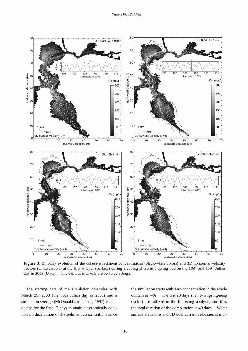
Yusuke UCHIYAMA
Msdl
Figure 3 Bihourly evolution of the cohesive sediment concentrations (black-white colors) and 3D horizontal velocityvectors (white arrows) at the first σ-layer (surface) during a ebbing phase in a spring tide on the 108th and 109th Julianday in 2003 (UTC) The contour intervals are set to be 50mgl
The starting date of the simulation coincides with arch 29 2003 (the 88th Julian day in 2003) and a
imulation spin-up (McDonald and Cheng 1997) is con-ucted for the first 12 days to attain a dynamically equi-ibrium distribution of the sediment concentrations since
the simulation starts with zero concentration in the whole domain at t=0s The last 28 days (ie two spring-neap cycles) are utilized in the following analysis and thus the total duration of the computation is 40 days Water surface elevations and 3D tidal current velocities at mul-
-10-
Modeling three-dimensional cohesive sediment transport and associated morphological response in estuarine intertidal mudflats
Figure 4 Same as Figure 3 but during a flooding phase
tiple locations along the coast line of San Francisco Bay have already validated with the observed data to repre-sent that WD-POM is able to accurately reproduce the hydrodynamics in the whole bay (Uchiyama 2004)
Figures 3 and 4 show the bihourly development of the sediment concentrations and the 3D horizontal cur-rent velocity vectors at the first σ-layer for 14 hours on the 108th to 109th Julian day in 2003 in UTC The model outputs exhibit that during a spring tide cohesive
-11-
Yusuke UCHIYAMA
Table 3 Statistical summary of the near-bottom suspended sediment concentrations measured in San Francisco Bay ob-served by USGS (Buchanan and Ruhl 2001) The locations of the measurement sites are plotted in Figure 1 The concentrations are measured by optical backscatterance sensors (OBSs) calibrated with sampled turbid waters
Site mean (mgl) median (mgl) Mallard Island 46 58 Carquinez Bridge 203 297 Mare Island Causeway 186 235 Channel Marker 9 213 263 Point San Pablo 81 99 Pier 24 33 38 Channel Marker 17 171 215 Dumbarton Bridge 150 190 San Mateo Bridge 60 73
mid-depth concentration
sediments are suspended dominantly in the deeper chan-nels while being transported and deposited on the inter-tidal areas fringing the bay at flooding phases This tendency can also be observed during neap tides although magnitude of the variations is much smaller (not shown here) than those for the spring tides In South San Francisco Bay the concentrations are not as high as those in San Pablo Bay as weaker tidal currents are generated in South Bay The sediment concentra-tions in San Pablo Bay are estimated from the simulation to range from 0 to 300 mgl while those in South Bay vary about 0-200 mgl These ranges of the fluctuations reasonably agree with the observed data as listed in Ta-ble 3 and displayed in Figure 5 The measured con-centrations range from 0 to 150 mgl in the whole bay indicating higher concentrations in San Pablo Bay and Suisun Bay while lower in South Bay The median concentrations fluctuate from 99 (Point San Pablo) to 297 mgl (Carquinez Bridge) in San Pablo Bay although in South Bay ranging from 38 (Pier 24 Central Bay) to 215 mgl (Channel Marker 17 South Bay) as indicated in Table 3 (after Buchanan and Ruhl 2001) In addi-tion to the in situ measurements the satellite image analysis gave us the instantaneous surface sediment con-centrations as displayed in Figure 5 (after Ruhl et al 2001) The image was taken on March 25 1995 at 1300 and the concentrations are inferred from the bands-1 and -2 of the NOAA-14 AVHRR and calibrated with the measured data using optical backscatterance sensors These observed results clearly support that the
model presented here is capable of realistically reproduc-ing the cohesive sediment concentrations in San Fran-cisco Bay However because the concentrations may significantly increase in response to riverine discharges and wind condition it is necessary to implement these effects into the model in the future
The incoming tidal waves are propagating as anti-clockwise Kelvin waves but significantly refracted on the intertidal slopes in San Francisco Bay (Uchiyama 2004) presumably to boost the instantaneous as well as residual velocity component normal to the isobaths par-ticularly in the intertidal areas Figures 3 and 4 also exhibit that in San Pablo Bay the bed cohesive sediments begin to be resuspended in the channels during an ebbing phase (at 14h) and subsequently being carried in the di-rection of ebb tidal currents (at 16h through 18h) Next the resuspended sediments appear to be transported onto the intertidal areas in response to the rising tides and to approach the shoreline during floods (at 18h through 22h) and finally the sediments are diluted perhaps by deposition (at 22h though 2h) Figure 5 shows a simi-lar pattern in which higher concentrations appear to be around the deeper channels although lower on the inter-tidal shallow areas This spatial distribution of the sediment concentrations is most likely induced by the tidal current component normal to the isobaths and may provoke specific topography variation in the bay as dis-cussed later
-12-
Modeling three-dimensional cohesive sediment transport and associated morphological response in estuarine intertidal mudflats
Figure 5 A NOAA-AVHRR image corresponding to the instantaneous sediment concentrations in San Francisco Bayon March 25 1995 at 1300h (after Ruhl et al 2001)
42 Geomorphological Variations
The morphological changes due to the tidal currents during two spring-neap cycles (28 days) in San Pablo Bay and South Bay are estimated as shown in Figure 6 Intertidal mudflats tend to slightly be accreted whereas deeper channels seem rather eroded in the both subem-bayments This result is obviously consistent with the temporal development of the cohesive sediment concen-trations as sequently indicated in Figures 3 and 4 Sediment resuspension is predominant in the deeper channels to generate suspended cohesive sediments re-sulting in significant erosion The sediments are then transported and deposited onto the intertidal areas to en-hance accretion
This computed geomorphological pattern is next compared with surveyed topography variations Figure 7 (a) shows the bathymetry-change rate in San Pablo Bay calculated with the historical bathymetry surveys conducted by COOPS-NOS-NOAA in 1922 and 1951 and summarized by USGS (after Jaffe et al 1998)
The channel is eroded by about 24m for 29 years be-tween two surveys to yield ~10cmy as shown in Figure 7 (a) The simulated maximum erosion rate is about 10-20 cmy demonstrating the model can qualitatively replicate the geomorphological behavior in San Pablo Bay realistically This consistency also suggests that the sediment transport and associated bathymetry varia-tions are largely controlled by tidal currents However the locations of the most accretive regions inferred by the model outputs are slightly different from those by the surveys probably because the model neglects the surface wind stress waves and fluvial discharges and employs the simplified sediment submodels Similar compari-son can be done by examining Figures 6 (b) and 7 (b) which exhibits bathymetry changes between 1931 and 1956 in South Bay on the basis of the surveys (after Foxgrover et al 2004) The bathymetry tends to vary at around plusmn2-3cmy in the simulated results although about plusmn1-2cmy calculated from the surveys The model-generated morphological pattern is much different from that evaluated by the surveys Accretion pre-
-13-
Yusuke UCHIYAMA
(a) San Pablo Bay ndash Central San Francisco Bay (b) South San Francisco Bay
Figure 6 Model-estimated bathymetry changes in (a) San Pablo Bay and (b) South San Francisco Bay
(a) San Pablo Bay ndash Central San Francisco Bay (b) South San Francisco Bay
Figure 7 The erosion and accretion rate estimated for the historical bathymetric surveys conducted by CO-OPS NOS-NOAA in (a) San Pablo Bay (after Jaffe et al 1998) and (b) South San Francisco Bay (after Foxgroverl et al 2004)
dominantly occurs in the whole South Bay according to the surveyed results while the model output shows that the intertidal areas are largely eroded This inconsis-tency may also be caused by the neglecting hydrody-namic components such as wind and waves which gen-erally enhance erosion
5 DISCUSSION
The model is qualitatively able to estimate the cohe-sive sediment transport and resultant bathymetry varia-tions with having a realistic agreement with the observed
-14-
Modeling three-dimensional cohesive sediment transport and associated morphological response in estuarine intertidal mudflats
Figure 8 Long-term accretion on an intertidal sloping topography Only a sinusoidal tidal oscillation is considered at the open boundary (the left side)
results An important finding here is that the tidal cur-rents have a key role in the sediment resuspension and the subembayment or inter-embayment scale dispersion of the resuspended sediments to induce erosion in the deeper channels and accretion in the intertidal areas In order to verify this accretive effect of tidal currents on intertidal topography a 2D-vertical long-term simulation of sediment transport and morphological response on a uniform intertidal slope is performed The initial beach slope is set at 1500 and monochromatic sinusoidal tidal oscillations with amplitude of 12m and at a period of 12h are imposed on the open boundary condition located at the cross-shore distance of 0km in Figure 8 The sedimentological parameters and the other boundary conditions are same as those used in the 3D simulation for San Francisco Bay except the open boundary condi-tion for the sediment concentration In the 2D simula-tion a constant value of C0 (C0 is set 100 mgl here) is used for the sediment concentrations when the direction of currents at the open boundary is landward The nu-merical parameters are set here as ∆ te = 2s ∆ ti = 60s ∆ x = 100m 5 vertical σ-layers are used and the Coriolis terms are eliminated
The computed long-term morphological evolution is found to be similar to the results of the 3D simulation The flooding tides evidently amplify the shoreward sediment transport to be deposited near the shoreline and accordingly enhance the accretion in the intertidal areas As a consequent the intertidal topography is de-veloped gradually near the high water mark The cross-shore topography after 100 years is resemble the results
with more simplified 1D models proposed by Roberts et al (2000) and Pritchard et al (2002) This result also suggests that tidal currents evidently influence to raise the sediment deposition on the intertidal areas and to create the flat topography near the shoreline 6 CONCLUSIONS
Cohesive sediment transport and resultant bathymetry response in estuaries encompassed by intertidal area are developed on the basis of WD-POM The primary ad-vantage of the model is its ability to simulate the vertical hydrodynamics (vertical profiles of 3D velocities turbu-lence sediments and other passive scalars) even though the water surface descends to become extremely shallow The model employs the widely-used parameterizations involving the erosion rate submodel by Krone (1962) the deposition rate submodel by Partheniades (1992) and the settling speed submodel by Burban et al (1990)
The model is applied to San Francisco Bay CA USA which is fringed by extensive intertidal mudflats The model outputs are compared to the observed results by Buchanan and Ruhl (2001) Ruhl et al (2001) Jaffe et al (1998) and Foxgrover et al (2004) to exhibit a reasonable agreement The simulated results indicate that the sediments are remarkably suspended in the deeper channels while deposited on the intertidal fringes This sediment transport induces significant erosion in the channel and visible accretion in the intertidal mudflats The intertidal areas play an important role in the sedi-ment budgets in the estuary acting as lsquosinkrsquo of the sus-
-15-
Yusuke UCHIYAMA
pended cohesive sediments under action of the tidal cur-rents A supplemental 2D vertical simulation with a simplified numerical setting also supports the results educed from the 3D simulation to demonstrate that tidal currents have evident influence on transporting the re-suspended sediment shoreward and enhancing accumula-tion to create mudflat topographies ACKNOWLEDGEMENTS
This research project was partially supported by Ja-pan Society for Promotion of Science and is a part of the authorrsquos work during his stay at University of California Berkeley USA since March 2002 till March 2004 The author would like to express sincere appreciation to Professor Mark T Stacey of UC Berkeley Professor Rodney J Sobey of Imperial College of London UK and Mr Yasuyuki Nakagawa of Port and Airport Re-search Institute Japan for their helpful comments on the manuscript Thanks are also due to Mr Satoshi Inagaki of Kajima Corporation Dr Jeremy D Bricker of Kobe University Dr Stefan A Talke and Dr David K Ral-ston of UC Berkeley for their discussion on the numeri-cal modeling and help with searching for the literatures
(Accepted on November 10 2004) REFERENCES Ariathurai R and Krone RB 1976 Mathematical
modeling of sediment transport in estuaries Circula-tion Sediments and Transfer of Material in the Estu-ary Wiley ML (ed) Estuarine Processes 11 Aca-demic Press New York USA 98-106
Asmus RM Jensen MH Jensen KM Kristensen E Asmus H and Wille A 1998 The role of water movement and spatial scaling for measurement of dis-solved inorganic nitrogen fluxes in intertidal sedi-ments Estuar Coast Shelf Sci 46 221-232
Barros AP and Baptista AM 1989 An Eulerian-Lagrangian model for sediment transport in estuaries In Estuarine and Coastal Modeling M Spaulding (ed) ASCE 1 102-112
Black KS Tolhurst TJ Paterson DM and Hager-they SE 2002 Working with natural cohesive sediments J Hydr Eng 128 2-8
Blumberg AF and Mellor GL 1983 Diagnostic and prognostic numerical circulation studies of the South Atlantic Bight J Geophys Res 88 4579-4593
Blumberg AF and Mellor GL 1987 A description of a three-dimensional coastal ocean circulation model In Three-dimensional Coastal Ocean Models Vol4 Heaps N (ed) Ameri Geophys Union Washington DC pp208
Bricker JD Inagaki S and Monismith SG 2004 Modeling the effects of bed drag coefficient variabil-ity under wind waves in South San Francisco Bay Proc 8th Intrsquol Conf Coastal and Estuarine Modeling ASCE Monterey CA USA (in print Pers Comm)
Buchanan PA and Ruhl CA 2001 Summary of sus-pended-sediment concentration data San Francisco Bay California Water Year 1999 Open-File Report 01-100 US Geological Survey Sacramento CA USA 40pp
Burban PY Xu Y McNeil J and Lick W 1990 Settling speeds of flocs in fresh and sea waters J Geophys Res 95 18213-18220
Cabrita MT and Brotas V 2000 Seasonal variation in denitrification and dissolved nitrogen fluxes in inter-tidal sediments of Tagus estuary Portugal Mar Ecol Progress Ser 202 51-65
Casulli V and Cattani E 1994 Stability accuracy and efficiency of a semi-implicit method for three-dimensional shallow water flow Computers and Mathematics with Application 27 99-112
Cheng RT Casulli V and Gartner JW 1993 Tidal residual intertidal mudflat (TRIM) model and its ap-plication to San Francisco Bay California Estuar Coastal Shelf Sci 36 235-280
Christensen B Vedel A and Kristensen E 2000 Carbon and nitrogen fluxes in sediment inhabited by suspension-feeding (Nereis diversicolor) and non-suspension feeding (N Virens) polychaetes Mar Ecol Progress Ser 192 203-217
Christie MC and Dyer KR 1998 Measurements of the turbid tidal edge over Skeffling mudflats In Black KS Patterson DM and Cramp A (eds) Sedimentary processes in the intertidal zone Geo-logical Society London UK 139 45-55
-16-
Modeling three-dimensional cohesive sediment transport and associated morphological response in estuarine intertidal mudflats
Conomos TJ Smith RE and Gartner JW 1985 En-vironmental setting of San Francisco Bay Hydrobi-ologia 129 1-12
De Jonge VN and van Beusekom JEE 1995 Wind- and tide-induced resuspension of sediment and mi-crophytobenthos from tidal flats in the Ems estuary Limnol Oceanogr 40 766-778
Dyer KR 1986 Intertidal areas In Coastal and Es-tuarine Sediment Dynamics John Wiley amp Sons Ltd Chichester UK 260-264
Dyer KR 1998 The typology of intertidal mudflats In Black KS Patterson DM and Cramp A (eds) Sedimentary processes in the intertidal zone Geo-logical Society London UK 139 11-24
Foxgrover AC Higgins SA Ingraca MK Jaffe BE and Smith RE 2004 Deposition Erosion and Bathymetric Change in South San Francisco Bay 1858 ndash 1983 Open-File Report 2004-1192 US Geo-logical Survey Santa Cruz CA USA 23pp
Galperin B Kantha LH Hassid S and Rosati A 1988 A quasi-equilibrium turbulent energy model for geophysical flows J Atmos Sci 45 55-62
Gross ES Koseff JR and Monismith SG 1999 Three-dimensional salinity simulations of South San Francisco Bay J Hydraulic Eng 125 1199-1209
Hayter EJ 1983 Prediction of cohesive sediment movement in estuarial waters PhD thesis Univer-sity of Florida Gainesville FL USA 363pp
Hayter EJ and Pakala CV 1989 Transport of inor-ganic contaminants in estuarial waters J Coastal Res 5 217-230
HydroQual Inc 2002 A primer for ECOMSED Users Manual Ver 13 HydroQual Inc Mahwah NJ USA 188pp
Inagaki S 2000 Effects of a proposed San Francisco airport runway extension on hydrodynamics and sediment transport in South San Francisco Bay En-gineerrsquos Degree Thesis Stanford University Stan-ford CA USA
Jaffe BE Smith RE and Torresan LZ 1998 Sedi-mentation and Bathymetric Change in San Pablo Bay 1856ndash1983 Open-File Report 98-759 US Geologi-cal Survey Menlo Park CA USA
Kerner M 1993 Coupling of microbial fermentation and respiration processes in an intertidal mudflat of the Elbe estuary Limnol Oceanogr 38 314-330
Krone RB 1962 Flume study of the transport of sediment in estuarial processes Final Report Hy-draulic Eng Lab and Sanitary Eng Res Lab Univ Calif Berkeley CA USA
Kuwae T Hosokawa Y and Eguchi N 1998 Dis-solved inorganic nitrogen cycling in Banzu intertidal sand-flat Japan Mangroves and Salt Marshes 2 167-175
Kuwae T Kibe E and Nakamura Y 2003 Effect of emersion and immersion on the porewater nutrient dynamics of an intertidal sandflat in Tokyo Bay Estu Coastal Shelf Sci 57 929-940
Lee DH Bedford KW and Yen CJ 1994 Storm and entrainment effects on tributary sediment loads J Hydr Eng 120 81-103
Li Y and Parchure TM 1998 Mudbanks of the southwest coast of India VI Suspended sediment profiles J Coastal Res 14 (4) 1363-1372
MacIntyre S Lick W and Tsai CH 1990 Variability of entrainment of cohesive sediments in freshwater Biogeochemistry 9 187-209
McDonald ET and Cheng RT 1997 A numerical model of sediment transport applied to San Francisco Bay California J Marine Env Eng 4 1-41
Mellor GL and Yamada T 1982 Development of a turbulence closure model for geophysical fluid prob-lems Rev Geophys Space Phys 20 851-875
Nakagawa Y 2003 Numerical modeling of fine sedi-ment transport processes in the Ariake Bay Rep Port and Airport Res Inst Port and Airport Res Inst Yokosuka Japan Vol42 (4) 25-42 (in Japanese with an English abstract)
Nakagawa Y 2005 Fine sediment transport in Ariake Bay Japan Proc INTERCOH 2003 (in print Pers Comm)
Oey L-Y 2005 A wetting and drying scheme for POM Ocean Modeling 8 (in press Pers Comm)
Partheniades E 1992 Estuarine sediment dynamics and shoaling processes In Herbick J (ed) Handbook of Coastal and Ocean Engineering 3 985-1071
Pritchard D Hogg AJ and Roberts W 2002 Mor-phological modelling of intertidal mudflats the role
-17-
Yusuke UCHIYAMA
of cross-shore tidal currents Cont Shelf Res 22 1887-1895
Ralston DK and Stacey MT 2004 Three-dimensional modeling of intertidal flow and transport Periodic stratification and its implications for sedi-ment transport Suppl AGU Chapman Conf Salt-marsh Geomorphology Amer Geophys Union Hali-fax NS Canada 27-28
Roberts W Le Hir P and Whitehouse RJS 2000 Investigation using simple mathematical models of the effect of tidal currents and waves on the profile shape of intertidal mudflats Cont Shelf Res 20 1079-1097
Ruhl CA Schoelhammer DH Stumpf RP and Lindsay CL 2001 Combined use of remote sensing and continuous monitoring to analyse the variability of suspended sediment concentrations in San Fran-cisco Bay California Estur Coastal Shelf Sci 53 801-812
Sheng YP and Lick W 1979 The transport and re-suspension of sediments in a shallow lake J Geo-phys Res 84 (C4) 1809-1826
Shrestha PL Blumberg AF Di Toro DM and Hell-weger F 2000 A three-dimensional model for cohe-sive sediment transport in shallow bays ASCE Joint Conf Water Resour Eng and Water Resour Plan-ning and Management Minneapolis MN USA
Siegel SW and Bachand PAM 2002 Feasibility analysis South Bay Salt Pond Restoration Wetlands and Water Resources San Rafael CA USA 228 pp
Smolarkiewicz PK 1984 A fully multidimensional positive definite advection transport algorithm with small implicit diffusion J Comp Phys 54 325-362
Tsai CH and Lick W 1987 Resuspension of sedi-ments from Long Island Sound Wat Sci Tech 21 (6-7) 155-184
Talke SA and Stacey MT 2003 The influence of oceanic swell on flows over an estuarine intertidal mudflat in San Francisco Bay Estuar Coastal Shelf Sci 58 541-554
Thomas WA and McAnally WHJr 1985 Userrsquos manual for the generalized computer program system open-channel flow and sedimentation TABS-2 In-struction Report HL85-1 US Army Engineer Water-ways Experimental Station Vicksburg MS USA
Tsuruya K Murakami K and Irie K 1990 Mathe-matical modeling of mud transport in ports with a multilayer model ndash Application to Kumamoto Port- Rep Port and Harbour Res Inst Port and Harbour Res Inst Yokosuka Japan Vol29 (1) 3-51
Uchiyama Y Kuriyama Y and Katoh K 2001 Sus-pended sediment and morphological response on Banzu tidal flat Japan Proc4th Intrsquol Conf Coastal Dynamics Ameri Soc Civil Eng Lund Sweden 1038-1047
Uchiyama Y 2004 Modeling wetting and drying scheme based on an extended logarithmic law for a three-dimensional sigma-coordinate coastal ocean model Rep Port and Airport Res Inst Port and Air-port Res Inst Yokosuka Japan 43 (4) 3-21
Van der Lee WTB 1998 The impact of fluid shear and the suspended sediment concentration on the mud floc size variation in the Dollard estuary The Nether-lands In Black KS Patterson DM and Cramp A (eds) Sedimentary processes in the intertidal zone Geological Society London UK 139 187-198
Van der Lee WTB 2000 Temporal variation of floc size and settling velocity in the Dollard estuary Con-tinental Shelf Res 20 1495 ndash 1511
Wang XH 2001 A numerical study of sediment trans-port in a coastal embayment during winter storms J Coastal Res 34 414-427
Wang XH 2002 Tide-induced sediment resuspension and the bottom boundary layer in an idealized estuary with a muddy bed J Phys Oceanogr 32 3113-3131
WhitehouseRJS and Mitchener HJ 1998 Observa-tions of the morphodynamic behavior of an intertidal mudflat at different timescales In Black KS Pat-terson DM and Cramp A (eds) Sedimentary proc-esses in the intertidal zone Geological Society Lon-don UK 139 255-271
Whitehouse RJS Soulsby RL Roberts W and MitchenerHJ 2000 Intertidal Processes In Dy-namics of estuarine muds Thomas Telford London UK 163-168
Widdows J Brinsley M and Elliott M 1998 Use of in-situ flume to quantify particle flux (biodeposition rates and sediment erosion) for an intertidal mudflat in relation to changes in current velocity and benthic
-18-
Modeling three-dimensional cohesive sediment transport and associated morphological response in estuarine intertidal mudflats
Zheng L Chen C and Liu H 2003 A modeling study of the Satilla River Estuary Georgia I Flooding-drying process and water exchange over the salt marsh-estuary-shelf complex Estuaries 26 (3) 651-669
macrofauna In Black KS Patterson DM and Cramp A (eds) Sedimentary processes in the inter-tidal zone Geological Society London UK 139 85-97
Wood RG Black KS and Jago CF 1998 Meas-urements of preliminary modeling of current velocity over an intertidal mudflat In Black KS Patterson DM and Cramp A (eds) Sedimentary processes in the intertidal zone Geological Society London UK 139 167-175
Ziegler CK and Lick W 1988 The transport of fine-grained sediments in shallow waters Env Geol Water Sci 11 (1) 123-132
Ziegler CK and Nisbet BS 1994 Fine-grained sedi-ment transport in Pawtuxet River Rhode Island J Hydr Eng 120 (5) 561-576 Xie L Pietrafesa LJ and Peng M 2004 Incorpora-
tion of a mass-conserving inundation scheme into a three dimensional storm surge model J Coastal Res 20 282-296
Ziegler CK and Nisbet BS 1995 Long-term simula-tion of fine-grained sediment transport in large reser-vior J Hydr Eng 121 (11) 773-781
-19-

Modeling three-dimensional cohesive sediment transport and associated morphological response in estuarine intertidal mudflats
Figure 4 Same as Figure 3 but during a flooding phase
tiple locations along the coast line of San Francisco Bay have already validated with the observed data to repre-sent that WD-POM is able to accurately reproduce the hydrodynamics in the whole bay (Uchiyama 2004)
Figures 3 and 4 show the bihourly development of the sediment concentrations and the 3D horizontal cur-rent velocity vectors at the first σ-layer for 14 hours on the 108th to 109th Julian day in 2003 in UTC The model outputs exhibit that during a spring tide cohesive
-11-
Yusuke UCHIYAMA
Table 3 Statistical summary of the near-bottom suspended sediment concentrations measured in San Francisco Bay ob-served by USGS (Buchanan and Ruhl 2001) The locations of the measurement sites are plotted in Figure 1 The concentrations are measured by optical backscatterance sensors (OBSs) calibrated with sampled turbid waters
Site mean (mgl) median (mgl) Mallard Island 46 58 Carquinez Bridge 203 297 Mare Island Causeway 186 235 Channel Marker 9 213 263 Point San Pablo 81 99 Pier 24 33 38 Channel Marker 17 171 215 Dumbarton Bridge 150 190 San Mateo Bridge 60 73
mid-depth concentration
sediments are suspended dominantly in the deeper chan-nels while being transported and deposited on the inter-tidal areas fringing the bay at flooding phases This tendency can also be observed during neap tides although magnitude of the variations is much smaller (not shown here) than those for the spring tides In South San Francisco Bay the concentrations are not as high as those in San Pablo Bay as weaker tidal currents are generated in South Bay The sediment concentra-tions in San Pablo Bay are estimated from the simulation to range from 0 to 300 mgl while those in South Bay vary about 0-200 mgl These ranges of the fluctuations reasonably agree with the observed data as listed in Ta-ble 3 and displayed in Figure 5 The measured con-centrations range from 0 to 150 mgl in the whole bay indicating higher concentrations in San Pablo Bay and Suisun Bay while lower in South Bay The median concentrations fluctuate from 99 (Point San Pablo) to 297 mgl (Carquinez Bridge) in San Pablo Bay although in South Bay ranging from 38 (Pier 24 Central Bay) to 215 mgl (Channel Marker 17 South Bay) as indicated in Table 3 (after Buchanan and Ruhl 2001) In addi-tion to the in situ measurements the satellite image analysis gave us the instantaneous surface sediment con-centrations as displayed in Figure 5 (after Ruhl et al 2001) The image was taken on March 25 1995 at 1300 and the concentrations are inferred from the bands-1 and -2 of the NOAA-14 AVHRR and calibrated with the measured data using optical backscatterance sensors These observed results clearly support that the
model presented here is capable of realistically reproduc-ing the cohesive sediment concentrations in San Fran-cisco Bay However because the concentrations may significantly increase in response to riverine discharges and wind condition it is necessary to implement these effects into the model in the future
The incoming tidal waves are propagating as anti-clockwise Kelvin waves but significantly refracted on the intertidal slopes in San Francisco Bay (Uchiyama 2004) presumably to boost the instantaneous as well as residual velocity component normal to the isobaths par-ticularly in the intertidal areas Figures 3 and 4 also exhibit that in San Pablo Bay the bed cohesive sediments begin to be resuspended in the channels during an ebbing phase (at 14h) and subsequently being carried in the di-rection of ebb tidal currents (at 16h through 18h) Next the resuspended sediments appear to be transported onto the intertidal areas in response to the rising tides and to approach the shoreline during floods (at 18h through 22h) and finally the sediments are diluted perhaps by deposition (at 22h though 2h) Figure 5 shows a simi-lar pattern in which higher concentrations appear to be around the deeper channels although lower on the inter-tidal shallow areas This spatial distribution of the sediment concentrations is most likely induced by the tidal current component normal to the isobaths and may provoke specific topography variation in the bay as dis-cussed later
-12-
Modeling three-dimensional cohesive sediment transport and associated morphological response in estuarine intertidal mudflats
Figure 5 A NOAA-AVHRR image corresponding to the instantaneous sediment concentrations in San Francisco Bayon March 25 1995 at 1300h (after Ruhl et al 2001)
42 Geomorphological Variations
The morphological changes due to the tidal currents during two spring-neap cycles (28 days) in San Pablo Bay and South Bay are estimated as shown in Figure 6 Intertidal mudflats tend to slightly be accreted whereas deeper channels seem rather eroded in the both subem-bayments This result is obviously consistent with the temporal development of the cohesive sediment concen-trations as sequently indicated in Figures 3 and 4 Sediment resuspension is predominant in the deeper channels to generate suspended cohesive sediments re-sulting in significant erosion The sediments are then transported and deposited onto the intertidal areas to en-hance accretion
This computed geomorphological pattern is next compared with surveyed topography variations Figure 7 (a) shows the bathymetry-change rate in San Pablo Bay calculated with the historical bathymetry surveys conducted by COOPS-NOS-NOAA in 1922 and 1951 and summarized by USGS (after Jaffe et al 1998)
The channel is eroded by about 24m for 29 years be-tween two surveys to yield ~10cmy as shown in Figure 7 (a) The simulated maximum erosion rate is about 10-20 cmy demonstrating the model can qualitatively replicate the geomorphological behavior in San Pablo Bay realistically This consistency also suggests that the sediment transport and associated bathymetry varia-tions are largely controlled by tidal currents However the locations of the most accretive regions inferred by the model outputs are slightly different from those by the surveys probably because the model neglects the surface wind stress waves and fluvial discharges and employs the simplified sediment submodels Similar compari-son can be done by examining Figures 6 (b) and 7 (b) which exhibits bathymetry changes between 1931 and 1956 in South Bay on the basis of the surveys (after Foxgrover et al 2004) The bathymetry tends to vary at around plusmn2-3cmy in the simulated results although about plusmn1-2cmy calculated from the surveys The model-generated morphological pattern is much different from that evaluated by the surveys Accretion pre-
-13-
Yusuke UCHIYAMA
(a) San Pablo Bay ndash Central San Francisco Bay (b) South San Francisco Bay
Figure 6 Model-estimated bathymetry changes in (a) San Pablo Bay and (b) South San Francisco Bay
(a) San Pablo Bay ndash Central San Francisco Bay (b) South San Francisco Bay
Figure 7 The erosion and accretion rate estimated for the historical bathymetric surveys conducted by CO-OPS NOS-NOAA in (a) San Pablo Bay (after Jaffe et al 1998) and (b) South San Francisco Bay (after Foxgroverl et al 2004)
dominantly occurs in the whole South Bay according to the surveyed results while the model output shows that the intertidal areas are largely eroded This inconsis-tency may also be caused by the neglecting hydrody-namic components such as wind and waves which gen-erally enhance erosion
5 DISCUSSION
The model is qualitatively able to estimate the cohe-sive sediment transport and resultant bathymetry varia-tions with having a realistic agreement with the observed
-14-
Modeling three-dimensional cohesive sediment transport and associated morphological response in estuarine intertidal mudflats
Figure 8 Long-term accretion on an intertidal sloping topography Only a sinusoidal tidal oscillation is considered at the open boundary (the left side)
results An important finding here is that the tidal cur-rents have a key role in the sediment resuspension and the subembayment or inter-embayment scale dispersion of the resuspended sediments to induce erosion in the deeper channels and accretion in the intertidal areas In order to verify this accretive effect of tidal currents on intertidal topography a 2D-vertical long-term simulation of sediment transport and morphological response on a uniform intertidal slope is performed The initial beach slope is set at 1500 and monochromatic sinusoidal tidal oscillations with amplitude of 12m and at a period of 12h are imposed on the open boundary condition located at the cross-shore distance of 0km in Figure 8 The sedimentological parameters and the other boundary conditions are same as those used in the 3D simulation for San Francisco Bay except the open boundary condi-tion for the sediment concentration In the 2D simula-tion a constant value of C0 (C0 is set 100 mgl here) is used for the sediment concentrations when the direction of currents at the open boundary is landward The nu-merical parameters are set here as ∆ te = 2s ∆ ti = 60s ∆ x = 100m 5 vertical σ-layers are used and the Coriolis terms are eliminated
The computed long-term morphological evolution is found to be similar to the results of the 3D simulation The flooding tides evidently amplify the shoreward sediment transport to be deposited near the shoreline and accordingly enhance the accretion in the intertidal areas As a consequent the intertidal topography is de-veloped gradually near the high water mark The cross-shore topography after 100 years is resemble the results
with more simplified 1D models proposed by Roberts et al (2000) and Pritchard et al (2002) This result also suggests that tidal currents evidently influence to raise the sediment deposition on the intertidal areas and to create the flat topography near the shoreline 6 CONCLUSIONS
Cohesive sediment transport and resultant bathymetry response in estuaries encompassed by intertidal area are developed on the basis of WD-POM The primary ad-vantage of the model is its ability to simulate the vertical hydrodynamics (vertical profiles of 3D velocities turbu-lence sediments and other passive scalars) even though the water surface descends to become extremely shallow The model employs the widely-used parameterizations involving the erosion rate submodel by Krone (1962) the deposition rate submodel by Partheniades (1992) and the settling speed submodel by Burban et al (1990)
The model is applied to San Francisco Bay CA USA which is fringed by extensive intertidal mudflats The model outputs are compared to the observed results by Buchanan and Ruhl (2001) Ruhl et al (2001) Jaffe et al (1998) and Foxgrover et al (2004) to exhibit a reasonable agreement The simulated results indicate that the sediments are remarkably suspended in the deeper channels while deposited on the intertidal fringes This sediment transport induces significant erosion in the channel and visible accretion in the intertidal mudflats The intertidal areas play an important role in the sedi-ment budgets in the estuary acting as lsquosinkrsquo of the sus-
-15-
Yusuke UCHIYAMA
pended cohesive sediments under action of the tidal cur-rents A supplemental 2D vertical simulation with a simplified numerical setting also supports the results educed from the 3D simulation to demonstrate that tidal currents have evident influence on transporting the re-suspended sediment shoreward and enhancing accumula-tion to create mudflat topographies ACKNOWLEDGEMENTS
This research project was partially supported by Ja-pan Society for Promotion of Science and is a part of the authorrsquos work during his stay at University of California Berkeley USA since March 2002 till March 2004 The author would like to express sincere appreciation to Professor Mark T Stacey of UC Berkeley Professor Rodney J Sobey of Imperial College of London UK and Mr Yasuyuki Nakagawa of Port and Airport Re-search Institute Japan for their helpful comments on the manuscript Thanks are also due to Mr Satoshi Inagaki of Kajima Corporation Dr Jeremy D Bricker of Kobe University Dr Stefan A Talke and Dr David K Ral-ston of UC Berkeley for their discussion on the numeri-cal modeling and help with searching for the literatures
(Accepted on November 10 2004) REFERENCES Ariathurai R and Krone RB 1976 Mathematical
modeling of sediment transport in estuaries Circula-tion Sediments and Transfer of Material in the Estu-ary Wiley ML (ed) Estuarine Processes 11 Aca-demic Press New York USA 98-106
Asmus RM Jensen MH Jensen KM Kristensen E Asmus H and Wille A 1998 The role of water movement and spatial scaling for measurement of dis-solved inorganic nitrogen fluxes in intertidal sedi-ments Estuar Coast Shelf Sci 46 221-232
Barros AP and Baptista AM 1989 An Eulerian-Lagrangian model for sediment transport in estuaries In Estuarine and Coastal Modeling M Spaulding (ed) ASCE 1 102-112
Black KS Tolhurst TJ Paterson DM and Hager-they SE 2002 Working with natural cohesive sediments J Hydr Eng 128 2-8
Blumberg AF and Mellor GL 1983 Diagnostic and prognostic numerical circulation studies of the South Atlantic Bight J Geophys Res 88 4579-4593
Blumberg AF and Mellor GL 1987 A description of a three-dimensional coastal ocean circulation model In Three-dimensional Coastal Ocean Models Vol4 Heaps N (ed) Ameri Geophys Union Washington DC pp208
Bricker JD Inagaki S and Monismith SG 2004 Modeling the effects of bed drag coefficient variabil-ity under wind waves in South San Francisco Bay Proc 8th Intrsquol Conf Coastal and Estuarine Modeling ASCE Monterey CA USA (in print Pers Comm)
Buchanan PA and Ruhl CA 2001 Summary of sus-pended-sediment concentration data San Francisco Bay California Water Year 1999 Open-File Report 01-100 US Geological Survey Sacramento CA USA 40pp
Burban PY Xu Y McNeil J and Lick W 1990 Settling speeds of flocs in fresh and sea waters J Geophys Res 95 18213-18220
Cabrita MT and Brotas V 2000 Seasonal variation in denitrification and dissolved nitrogen fluxes in inter-tidal sediments of Tagus estuary Portugal Mar Ecol Progress Ser 202 51-65
Casulli V and Cattani E 1994 Stability accuracy and efficiency of a semi-implicit method for three-dimensional shallow water flow Computers and Mathematics with Application 27 99-112
Cheng RT Casulli V and Gartner JW 1993 Tidal residual intertidal mudflat (TRIM) model and its ap-plication to San Francisco Bay California Estuar Coastal Shelf Sci 36 235-280
Christensen B Vedel A and Kristensen E 2000 Carbon and nitrogen fluxes in sediment inhabited by suspension-feeding (Nereis diversicolor) and non-suspension feeding (N Virens) polychaetes Mar Ecol Progress Ser 192 203-217
Christie MC and Dyer KR 1998 Measurements of the turbid tidal edge over Skeffling mudflats In Black KS Patterson DM and Cramp A (eds) Sedimentary processes in the intertidal zone Geo-logical Society London UK 139 45-55
-16-
Modeling three-dimensional cohesive sediment transport and associated morphological response in estuarine intertidal mudflats
Conomos TJ Smith RE and Gartner JW 1985 En-vironmental setting of San Francisco Bay Hydrobi-ologia 129 1-12
De Jonge VN and van Beusekom JEE 1995 Wind- and tide-induced resuspension of sediment and mi-crophytobenthos from tidal flats in the Ems estuary Limnol Oceanogr 40 766-778
Dyer KR 1986 Intertidal areas In Coastal and Es-tuarine Sediment Dynamics John Wiley amp Sons Ltd Chichester UK 260-264
Dyer KR 1998 The typology of intertidal mudflats In Black KS Patterson DM and Cramp A (eds) Sedimentary processes in the intertidal zone Geo-logical Society London UK 139 11-24
Foxgrover AC Higgins SA Ingraca MK Jaffe BE and Smith RE 2004 Deposition Erosion and Bathymetric Change in South San Francisco Bay 1858 ndash 1983 Open-File Report 2004-1192 US Geo-logical Survey Santa Cruz CA USA 23pp
Galperin B Kantha LH Hassid S and Rosati A 1988 A quasi-equilibrium turbulent energy model for geophysical flows J Atmos Sci 45 55-62
Gross ES Koseff JR and Monismith SG 1999 Three-dimensional salinity simulations of South San Francisco Bay J Hydraulic Eng 125 1199-1209
Hayter EJ 1983 Prediction of cohesive sediment movement in estuarial waters PhD thesis Univer-sity of Florida Gainesville FL USA 363pp
Hayter EJ and Pakala CV 1989 Transport of inor-ganic contaminants in estuarial waters J Coastal Res 5 217-230
HydroQual Inc 2002 A primer for ECOMSED Users Manual Ver 13 HydroQual Inc Mahwah NJ USA 188pp
Inagaki S 2000 Effects of a proposed San Francisco airport runway extension on hydrodynamics and sediment transport in South San Francisco Bay En-gineerrsquos Degree Thesis Stanford University Stan-ford CA USA
Jaffe BE Smith RE and Torresan LZ 1998 Sedi-mentation and Bathymetric Change in San Pablo Bay 1856ndash1983 Open-File Report 98-759 US Geologi-cal Survey Menlo Park CA USA
Kerner M 1993 Coupling of microbial fermentation and respiration processes in an intertidal mudflat of the Elbe estuary Limnol Oceanogr 38 314-330
Krone RB 1962 Flume study of the transport of sediment in estuarial processes Final Report Hy-draulic Eng Lab and Sanitary Eng Res Lab Univ Calif Berkeley CA USA
Kuwae T Hosokawa Y and Eguchi N 1998 Dis-solved inorganic nitrogen cycling in Banzu intertidal sand-flat Japan Mangroves and Salt Marshes 2 167-175
Kuwae T Kibe E and Nakamura Y 2003 Effect of emersion and immersion on the porewater nutrient dynamics of an intertidal sandflat in Tokyo Bay Estu Coastal Shelf Sci 57 929-940
Lee DH Bedford KW and Yen CJ 1994 Storm and entrainment effects on tributary sediment loads J Hydr Eng 120 81-103
Li Y and Parchure TM 1998 Mudbanks of the southwest coast of India VI Suspended sediment profiles J Coastal Res 14 (4) 1363-1372
MacIntyre S Lick W and Tsai CH 1990 Variability of entrainment of cohesive sediments in freshwater Biogeochemistry 9 187-209
McDonald ET and Cheng RT 1997 A numerical model of sediment transport applied to San Francisco Bay California J Marine Env Eng 4 1-41
Mellor GL and Yamada T 1982 Development of a turbulence closure model for geophysical fluid prob-lems Rev Geophys Space Phys 20 851-875
Nakagawa Y 2003 Numerical modeling of fine sedi-ment transport processes in the Ariake Bay Rep Port and Airport Res Inst Port and Airport Res Inst Yokosuka Japan Vol42 (4) 25-42 (in Japanese with an English abstract)
Nakagawa Y 2005 Fine sediment transport in Ariake Bay Japan Proc INTERCOH 2003 (in print Pers Comm)
Oey L-Y 2005 A wetting and drying scheme for POM Ocean Modeling 8 (in press Pers Comm)
Partheniades E 1992 Estuarine sediment dynamics and shoaling processes In Herbick J (ed) Handbook of Coastal and Ocean Engineering 3 985-1071
Pritchard D Hogg AJ and Roberts W 2002 Mor-phological modelling of intertidal mudflats the role
-17-
Yusuke UCHIYAMA
of cross-shore tidal currents Cont Shelf Res 22 1887-1895
Ralston DK and Stacey MT 2004 Three-dimensional modeling of intertidal flow and transport Periodic stratification and its implications for sedi-ment transport Suppl AGU Chapman Conf Salt-marsh Geomorphology Amer Geophys Union Hali-fax NS Canada 27-28
Roberts W Le Hir P and Whitehouse RJS 2000 Investigation using simple mathematical models of the effect of tidal currents and waves on the profile shape of intertidal mudflats Cont Shelf Res 20 1079-1097
Ruhl CA Schoelhammer DH Stumpf RP and Lindsay CL 2001 Combined use of remote sensing and continuous monitoring to analyse the variability of suspended sediment concentrations in San Fran-cisco Bay California Estur Coastal Shelf Sci 53 801-812
Sheng YP and Lick W 1979 The transport and re-suspension of sediments in a shallow lake J Geo-phys Res 84 (C4) 1809-1826
Shrestha PL Blumberg AF Di Toro DM and Hell-weger F 2000 A three-dimensional model for cohe-sive sediment transport in shallow bays ASCE Joint Conf Water Resour Eng and Water Resour Plan-ning and Management Minneapolis MN USA
Siegel SW and Bachand PAM 2002 Feasibility analysis South Bay Salt Pond Restoration Wetlands and Water Resources San Rafael CA USA 228 pp
Smolarkiewicz PK 1984 A fully multidimensional positive definite advection transport algorithm with small implicit diffusion J Comp Phys 54 325-362
Tsai CH and Lick W 1987 Resuspension of sedi-ments from Long Island Sound Wat Sci Tech 21 (6-7) 155-184
Talke SA and Stacey MT 2003 The influence of oceanic swell on flows over an estuarine intertidal mudflat in San Francisco Bay Estuar Coastal Shelf Sci 58 541-554
Thomas WA and McAnally WHJr 1985 Userrsquos manual for the generalized computer program system open-channel flow and sedimentation TABS-2 In-struction Report HL85-1 US Army Engineer Water-ways Experimental Station Vicksburg MS USA
Tsuruya K Murakami K and Irie K 1990 Mathe-matical modeling of mud transport in ports with a multilayer model ndash Application to Kumamoto Port- Rep Port and Harbour Res Inst Port and Harbour Res Inst Yokosuka Japan Vol29 (1) 3-51
Uchiyama Y Kuriyama Y and Katoh K 2001 Sus-pended sediment and morphological response on Banzu tidal flat Japan Proc4th Intrsquol Conf Coastal Dynamics Ameri Soc Civil Eng Lund Sweden 1038-1047
Uchiyama Y 2004 Modeling wetting and drying scheme based on an extended logarithmic law for a three-dimensional sigma-coordinate coastal ocean model Rep Port and Airport Res Inst Port and Air-port Res Inst Yokosuka Japan 43 (4) 3-21
Van der Lee WTB 1998 The impact of fluid shear and the suspended sediment concentration on the mud floc size variation in the Dollard estuary The Nether-lands In Black KS Patterson DM and Cramp A (eds) Sedimentary processes in the intertidal zone Geological Society London UK 139 187-198
Van der Lee WTB 2000 Temporal variation of floc size and settling velocity in the Dollard estuary Con-tinental Shelf Res 20 1495 ndash 1511
Wang XH 2001 A numerical study of sediment trans-port in a coastal embayment during winter storms J Coastal Res 34 414-427
Wang XH 2002 Tide-induced sediment resuspension and the bottom boundary layer in an idealized estuary with a muddy bed J Phys Oceanogr 32 3113-3131
WhitehouseRJS and Mitchener HJ 1998 Observa-tions of the morphodynamic behavior of an intertidal mudflat at different timescales In Black KS Pat-terson DM and Cramp A (eds) Sedimentary proc-esses in the intertidal zone Geological Society Lon-don UK 139 255-271
Whitehouse RJS Soulsby RL Roberts W and MitchenerHJ 2000 Intertidal Processes In Dy-namics of estuarine muds Thomas Telford London UK 163-168
Widdows J Brinsley M and Elliott M 1998 Use of in-situ flume to quantify particle flux (biodeposition rates and sediment erosion) for an intertidal mudflat in relation to changes in current velocity and benthic
-18-
Modeling three-dimensional cohesive sediment transport and associated morphological response in estuarine intertidal mudflats
Zheng L Chen C and Liu H 2003 A modeling study of the Satilla River Estuary Georgia I Flooding-drying process and water exchange over the salt marsh-estuary-shelf complex Estuaries 26 (3) 651-669
macrofauna In Black KS Patterson DM and Cramp A (eds) Sedimentary processes in the inter-tidal zone Geological Society London UK 139 85-97
Wood RG Black KS and Jago CF 1998 Meas-urements of preliminary modeling of current velocity over an intertidal mudflat In Black KS Patterson DM and Cramp A (eds) Sedimentary processes in the intertidal zone Geological Society London UK 139 167-175
Ziegler CK and Lick W 1988 The transport of fine-grained sediments in shallow waters Env Geol Water Sci 11 (1) 123-132
Ziegler CK and Nisbet BS 1994 Fine-grained sedi-ment transport in Pawtuxet River Rhode Island J Hydr Eng 120 (5) 561-576 Xie L Pietrafesa LJ and Peng M 2004 Incorpora-
tion of a mass-conserving inundation scheme into a three dimensional storm surge model J Coastal Res 20 282-296
Ziegler CK and Nisbet BS 1995 Long-term simula-tion of fine-grained sediment transport in large reser-vior J Hydr Eng 121 (11) 773-781
-19-

Yusuke UCHIYAMA
Table 3 Statistical summary of the near-bottom suspended sediment concentrations measured in San Francisco Bay ob-served by USGS (Buchanan and Ruhl 2001) The locations of the measurement sites are plotted in Figure 1 The concentrations are measured by optical backscatterance sensors (OBSs) calibrated with sampled turbid waters
Site mean (mgl) median (mgl) Mallard Island 46 58 Carquinez Bridge 203 297 Mare Island Causeway 186 235 Channel Marker 9 213 263 Point San Pablo 81 99 Pier 24 33 38 Channel Marker 17 171 215 Dumbarton Bridge 150 190 San Mateo Bridge 60 73
mid-depth concentration
sediments are suspended dominantly in the deeper chan-nels while being transported and deposited on the inter-tidal areas fringing the bay at flooding phases This tendency can also be observed during neap tides although magnitude of the variations is much smaller (not shown here) than those for the spring tides In South San Francisco Bay the concentrations are not as high as those in San Pablo Bay as weaker tidal currents are generated in South Bay The sediment concentra-tions in San Pablo Bay are estimated from the simulation to range from 0 to 300 mgl while those in South Bay vary about 0-200 mgl These ranges of the fluctuations reasonably agree with the observed data as listed in Ta-ble 3 and displayed in Figure 5 The measured con-centrations range from 0 to 150 mgl in the whole bay indicating higher concentrations in San Pablo Bay and Suisun Bay while lower in South Bay The median concentrations fluctuate from 99 (Point San Pablo) to 297 mgl (Carquinez Bridge) in San Pablo Bay although in South Bay ranging from 38 (Pier 24 Central Bay) to 215 mgl (Channel Marker 17 South Bay) as indicated in Table 3 (after Buchanan and Ruhl 2001) In addi-tion to the in situ measurements the satellite image analysis gave us the instantaneous surface sediment con-centrations as displayed in Figure 5 (after Ruhl et al 2001) The image was taken on March 25 1995 at 1300 and the concentrations are inferred from the bands-1 and -2 of the NOAA-14 AVHRR and calibrated with the measured data using optical backscatterance sensors These observed results clearly support that the
model presented here is capable of realistically reproduc-ing the cohesive sediment concentrations in San Fran-cisco Bay However because the concentrations may significantly increase in response to riverine discharges and wind condition it is necessary to implement these effects into the model in the future
The incoming tidal waves are propagating as anti-clockwise Kelvin waves but significantly refracted on the intertidal slopes in San Francisco Bay (Uchiyama 2004) presumably to boost the instantaneous as well as residual velocity component normal to the isobaths par-ticularly in the intertidal areas Figures 3 and 4 also exhibit that in San Pablo Bay the bed cohesive sediments begin to be resuspended in the channels during an ebbing phase (at 14h) and subsequently being carried in the di-rection of ebb tidal currents (at 16h through 18h) Next the resuspended sediments appear to be transported onto the intertidal areas in response to the rising tides and to approach the shoreline during floods (at 18h through 22h) and finally the sediments are diluted perhaps by deposition (at 22h though 2h) Figure 5 shows a simi-lar pattern in which higher concentrations appear to be around the deeper channels although lower on the inter-tidal shallow areas This spatial distribution of the sediment concentrations is most likely induced by the tidal current component normal to the isobaths and may provoke specific topography variation in the bay as dis-cussed later
-12-
Modeling three-dimensional cohesive sediment transport and associated morphological response in estuarine intertidal mudflats
Figure 5 A NOAA-AVHRR image corresponding to the instantaneous sediment concentrations in San Francisco Bayon March 25 1995 at 1300h (after Ruhl et al 2001)
42 Geomorphological Variations
The morphological changes due to the tidal currents during two spring-neap cycles (28 days) in San Pablo Bay and South Bay are estimated as shown in Figure 6 Intertidal mudflats tend to slightly be accreted whereas deeper channels seem rather eroded in the both subem-bayments This result is obviously consistent with the temporal development of the cohesive sediment concen-trations as sequently indicated in Figures 3 and 4 Sediment resuspension is predominant in the deeper channels to generate suspended cohesive sediments re-sulting in significant erosion The sediments are then transported and deposited onto the intertidal areas to en-hance accretion
This computed geomorphological pattern is next compared with surveyed topography variations Figure 7 (a) shows the bathymetry-change rate in San Pablo Bay calculated with the historical bathymetry surveys conducted by COOPS-NOS-NOAA in 1922 and 1951 and summarized by USGS (after Jaffe et al 1998)
The channel is eroded by about 24m for 29 years be-tween two surveys to yield ~10cmy as shown in Figure 7 (a) The simulated maximum erosion rate is about 10-20 cmy demonstrating the model can qualitatively replicate the geomorphological behavior in San Pablo Bay realistically This consistency also suggests that the sediment transport and associated bathymetry varia-tions are largely controlled by tidal currents However the locations of the most accretive regions inferred by the model outputs are slightly different from those by the surveys probably because the model neglects the surface wind stress waves and fluvial discharges and employs the simplified sediment submodels Similar compari-son can be done by examining Figures 6 (b) and 7 (b) which exhibits bathymetry changes between 1931 and 1956 in South Bay on the basis of the surveys (after Foxgrover et al 2004) The bathymetry tends to vary at around plusmn2-3cmy in the simulated results although about plusmn1-2cmy calculated from the surveys The model-generated morphological pattern is much different from that evaluated by the surveys Accretion pre-
-13-
Yusuke UCHIYAMA
(a) San Pablo Bay ndash Central San Francisco Bay (b) South San Francisco Bay
Figure 6 Model-estimated bathymetry changes in (a) San Pablo Bay and (b) South San Francisco Bay
(a) San Pablo Bay ndash Central San Francisco Bay (b) South San Francisco Bay
Figure 7 The erosion and accretion rate estimated for the historical bathymetric surveys conducted by CO-OPS NOS-NOAA in (a) San Pablo Bay (after Jaffe et al 1998) and (b) South San Francisco Bay (after Foxgroverl et al 2004)
dominantly occurs in the whole South Bay according to the surveyed results while the model output shows that the intertidal areas are largely eroded This inconsis-tency may also be caused by the neglecting hydrody-namic components such as wind and waves which gen-erally enhance erosion
5 DISCUSSION
The model is qualitatively able to estimate the cohe-sive sediment transport and resultant bathymetry varia-tions with having a realistic agreement with the observed
-14-
Modeling three-dimensional cohesive sediment transport and associated morphological response in estuarine intertidal mudflats
Figure 8 Long-term accretion on an intertidal sloping topography Only a sinusoidal tidal oscillation is considered at the open boundary (the left side)
results An important finding here is that the tidal cur-rents have a key role in the sediment resuspension and the subembayment or inter-embayment scale dispersion of the resuspended sediments to induce erosion in the deeper channels and accretion in the intertidal areas In order to verify this accretive effect of tidal currents on intertidal topography a 2D-vertical long-term simulation of sediment transport and morphological response on a uniform intertidal slope is performed The initial beach slope is set at 1500 and monochromatic sinusoidal tidal oscillations with amplitude of 12m and at a period of 12h are imposed on the open boundary condition located at the cross-shore distance of 0km in Figure 8 The sedimentological parameters and the other boundary conditions are same as those used in the 3D simulation for San Francisco Bay except the open boundary condi-tion for the sediment concentration In the 2D simula-tion a constant value of C0 (C0 is set 100 mgl here) is used for the sediment concentrations when the direction of currents at the open boundary is landward The nu-merical parameters are set here as ∆ te = 2s ∆ ti = 60s ∆ x = 100m 5 vertical σ-layers are used and the Coriolis terms are eliminated
The computed long-term morphological evolution is found to be similar to the results of the 3D simulation The flooding tides evidently amplify the shoreward sediment transport to be deposited near the shoreline and accordingly enhance the accretion in the intertidal areas As a consequent the intertidal topography is de-veloped gradually near the high water mark The cross-shore topography after 100 years is resemble the results
with more simplified 1D models proposed by Roberts et al (2000) and Pritchard et al (2002) This result also suggests that tidal currents evidently influence to raise the sediment deposition on the intertidal areas and to create the flat topography near the shoreline 6 CONCLUSIONS
Cohesive sediment transport and resultant bathymetry response in estuaries encompassed by intertidal area are developed on the basis of WD-POM The primary ad-vantage of the model is its ability to simulate the vertical hydrodynamics (vertical profiles of 3D velocities turbu-lence sediments and other passive scalars) even though the water surface descends to become extremely shallow The model employs the widely-used parameterizations involving the erosion rate submodel by Krone (1962) the deposition rate submodel by Partheniades (1992) and the settling speed submodel by Burban et al (1990)
The model is applied to San Francisco Bay CA USA which is fringed by extensive intertidal mudflats The model outputs are compared to the observed results by Buchanan and Ruhl (2001) Ruhl et al (2001) Jaffe et al (1998) and Foxgrover et al (2004) to exhibit a reasonable agreement The simulated results indicate that the sediments are remarkably suspended in the deeper channels while deposited on the intertidal fringes This sediment transport induces significant erosion in the channel and visible accretion in the intertidal mudflats The intertidal areas play an important role in the sedi-ment budgets in the estuary acting as lsquosinkrsquo of the sus-
-15-
Yusuke UCHIYAMA
pended cohesive sediments under action of the tidal cur-rents A supplemental 2D vertical simulation with a simplified numerical setting also supports the results educed from the 3D simulation to demonstrate that tidal currents have evident influence on transporting the re-suspended sediment shoreward and enhancing accumula-tion to create mudflat topographies ACKNOWLEDGEMENTS
This research project was partially supported by Ja-pan Society for Promotion of Science and is a part of the authorrsquos work during his stay at University of California Berkeley USA since March 2002 till March 2004 The author would like to express sincere appreciation to Professor Mark T Stacey of UC Berkeley Professor Rodney J Sobey of Imperial College of London UK and Mr Yasuyuki Nakagawa of Port and Airport Re-search Institute Japan for their helpful comments on the manuscript Thanks are also due to Mr Satoshi Inagaki of Kajima Corporation Dr Jeremy D Bricker of Kobe University Dr Stefan A Talke and Dr David K Ral-ston of UC Berkeley for their discussion on the numeri-cal modeling and help with searching for the literatures
(Accepted on November 10 2004) REFERENCES Ariathurai R and Krone RB 1976 Mathematical
modeling of sediment transport in estuaries Circula-tion Sediments and Transfer of Material in the Estu-ary Wiley ML (ed) Estuarine Processes 11 Aca-demic Press New York USA 98-106
Asmus RM Jensen MH Jensen KM Kristensen E Asmus H and Wille A 1998 The role of water movement and spatial scaling for measurement of dis-solved inorganic nitrogen fluxes in intertidal sedi-ments Estuar Coast Shelf Sci 46 221-232
Barros AP and Baptista AM 1989 An Eulerian-Lagrangian model for sediment transport in estuaries In Estuarine and Coastal Modeling M Spaulding (ed) ASCE 1 102-112
Black KS Tolhurst TJ Paterson DM and Hager-they SE 2002 Working with natural cohesive sediments J Hydr Eng 128 2-8
Blumberg AF and Mellor GL 1983 Diagnostic and prognostic numerical circulation studies of the South Atlantic Bight J Geophys Res 88 4579-4593
Blumberg AF and Mellor GL 1987 A description of a three-dimensional coastal ocean circulation model In Three-dimensional Coastal Ocean Models Vol4 Heaps N (ed) Ameri Geophys Union Washington DC pp208
Bricker JD Inagaki S and Monismith SG 2004 Modeling the effects of bed drag coefficient variabil-ity under wind waves in South San Francisco Bay Proc 8th Intrsquol Conf Coastal and Estuarine Modeling ASCE Monterey CA USA (in print Pers Comm)
Buchanan PA and Ruhl CA 2001 Summary of sus-pended-sediment concentration data San Francisco Bay California Water Year 1999 Open-File Report 01-100 US Geological Survey Sacramento CA USA 40pp
Burban PY Xu Y McNeil J and Lick W 1990 Settling speeds of flocs in fresh and sea waters J Geophys Res 95 18213-18220
Cabrita MT and Brotas V 2000 Seasonal variation in denitrification and dissolved nitrogen fluxes in inter-tidal sediments of Tagus estuary Portugal Mar Ecol Progress Ser 202 51-65
Casulli V and Cattani E 1994 Stability accuracy and efficiency of a semi-implicit method for three-dimensional shallow water flow Computers and Mathematics with Application 27 99-112
Cheng RT Casulli V and Gartner JW 1993 Tidal residual intertidal mudflat (TRIM) model and its ap-plication to San Francisco Bay California Estuar Coastal Shelf Sci 36 235-280
Christensen B Vedel A and Kristensen E 2000 Carbon and nitrogen fluxes in sediment inhabited by suspension-feeding (Nereis diversicolor) and non-suspension feeding (N Virens) polychaetes Mar Ecol Progress Ser 192 203-217
Christie MC and Dyer KR 1998 Measurements of the turbid tidal edge over Skeffling mudflats In Black KS Patterson DM and Cramp A (eds) Sedimentary processes in the intertidal zone Geo-logical Society London UK 139 45-55
-16-
Modeling three-dimensional cohesive sediment transport and associated morphological response in estuarine intertidal mudflats
Conomos TJ Smith RE and Gartner JW 1985 En-vironmental setting of San Francisco Bay Hydrobi-ologia 129 1-12
De Jonge VN and van Beusekom JEE 1995 Wind- and tide-induced resuspension of sediment and mi-crophytobenthos from tidal flats in the Ems estuary Limnol Oceanogr 40 766-778
Dyer KR 1986 Intertidal areas In Coastal and Es-tuarine Sediment Dynamics John Wiley amp Sons Ltd Chichester UK 260-264
Dyer KR 1998 The typology of intertidal mudflats In Black KS Patterson DM and Cramp A (eds) Sedimentary processes in the intertidal zone Geo-logical Society London UK 139 11-24
Foxgrover AC Higgins SA Ingraca MK Jaffe BE and Smith RE 2004 Deposition Erosion and Bathymetric Change in South San Francisco Bay 1858 ndash 1983 Open-File Report 2004-1192 US Geo-logical Survey Santa Cruz CA USA 23pp
Galperin B Kantha LH Hassid S and Rosati A 1988 A quasi-equilibrium turbulent energy model for geophysical flows J Atmos Sci 45 55-62
Gross ES Koseff JR and Monismith SG 1999 Three-dimensional salinity simulations of South San Francisco Bay J Hydraulic Eng 125 1199-1209
Hayter EJ 1983 Prediction of cohesive sediment movement in estuarial waters PhD thesis Univer-sity of Florida Gainesville FL USA 363pp
Hayter EJ and Pakala CV 1989 Transport of inor-ganic contaminants in estuarial waters J Coastal Res 5 217-230
HydroQual Inc 2002 A primer for ECOMSED Users Manual Ver 13 HydroQual Inc Mahwah NJ USA 188pp
Inagaki S 2000 Effects of a proposed San Francisco airport runway extension on hydrodynamics and sediment transport in South San Francisco Bay En-gineerrsquos Degree Thesis Stanford University Stan-ford CA USA
Jaffe BE Smith RE and Torresan LZ 1998 Sedi-mentation and Bathymetric Change in San Pablo Bay 1856ndash1983 Open-File Report 98-759 US Geologi-cal Survey Menlo Park CA USA
Kerner M 1993 Coupling of microbial fermentation and respiration processes in an intertidal mudflat of the Elbe estuary Limnol Oceanogr 38 314-330
Krone RB 1962 Flume study of the transport of sediment in estuarial processes Final Report Hy-draulic Eng Lab and Sanitary Eng Res Lab Univ Calif Berkeley CA USA
Kuwae T Hosokawa Y and Eguchi N 1998 Dis-solved inorganic nitrogen cycling in Banzu intertidal sand-flat Japan Mangroves and Salt Marshes 2 167-175
Kuwae T Kibe E and Nakamura Y 2003 Effect of emersion and immersion on the porewater nutrient dynamics of an intertidal sandflat in Tokyo Bay Estu Coastal Shelf Sci 57 929-940
Lee DH Bedford KW and Yen CJ 1994 Storm and entrainment effects on tributary sediment loads J Hydr Eng 120 81-103
Li Y and Parchure TM 1998 Mudbanks of the southwest coast of India VI Suspended sediment profiles J Coastal Res 14 (4) 1363-1372
MacIntyre S Lick W and Tsai CH 1990 Variability of entrainment of cohesive sediments in freshwater Biogeochemistry 9 187-209
McDonald ET and Cheng RT 1997 A numerical model of sediment transport applied to San Francisco Bay California J Marine Env Eng 4 1-41
Mellor GL and Yamada T 1982 Development of a turbulence closure model for geophysical fluid prob-lems Rev Geophys Space Phys 20 851-875
Nakagawa Y 2003 Numerical modeling of fine sedi-ment transport processes in the Ariake Bay Rep Port and Airport Res Inst Port and Airport Res Inst Yokosuka Japan Vol42 (4) 25-42 (in Japanese with an English abstract)
Nakagawa Y 2005 Fine sediment transport in Ariake Bay Japan Proc INTERCOH 2003 (in print Pers Comm)
Oey L-Y 2005 A wetting and drying scheme for POM Ocean Modeling 8 (in press Pers Comm)
Partheniades E 1992 Estuarine sediment dynamics and shoaling processes In Herbick J (ed) Handbook of Coastal and Ocean Engineering 3 985-1071
Pritchard D Hogg AJ and Roberts W 2002 Mor-phological modelling of intertidal mudflats the role
-17-
Yusuke UCHIYAMA
of cross-shore tidal currents Cont Shelf Res 22 1887-1895
Ralston DK and Stacey MT 2004 Three-dimensional modeling of intertidal flow and transport Periodic stratification and its implications for sedi-ment transport Suppl AGU Chapman Conf Salt-marsh Geomorphology Amer Geophys Union Hali-fax NS Canada 27-28
Roberts W Le Hir P and Whitehouse RJS 2000 Investigation using simple mathematical models of the effect of tidal currents and waves on the profile shape of intertidal mudflats Cont Shelf Res 20 1079-1097
Ruhl CA Schoelhammer DH Stumpf RP and Lindsay CL 2001 Combined use of remote sensing and continuous monitoring to analyse the variability of suspended sediment concentrations in San Fran-cisco Bay California Estur Coastal Shelf Sci 53 801-812
Sheng YP and Lick W 1979 The transport and re-suspension of sediments in a shallow lake J Geo-phys Res 84 (C4) 1809-1826
Shrestha PL Blumberg AF Di Toro DM and Hell-weger F 2000 A three-dimensional model for cohe-sive sediment transport in shallow bays ASCE Joint Conf Water Resour Eng and Water Resour Plan-ning and Management Minneapolis MN USA
Siegel SW and Bachand PAM 2002 Feasibility analysis South Bay Salt Pond Restoration Wetlands and Water Resources San Rafael CA USA 228 pp
Smolarkiewicz PK 1984 A fully multidimensional positive definite advection transport algorithm with small implicit diffusion J Comp Phys 54 325-362
Tsai CH and Lick W 1987 Resuspension of sedi-ments from Long Island Sound Wat Sci Tech 21 (6-7) 155-184
Talke SA and Stacey MT 2003 The influence of oceanic swell on flows over an estuarine intertidal mudflat in San Francisco Bay Estuar Coastal Shelf Sci 58 541-554
Thomas WA and McAnally WHJr 1985 Userrsquos manual for the generalized computer program system open-channel flow and sedimentation TABS-2 In-struction Report HL85-1 US Army Engineer Water-ways Experimental Station Vicksburg MS USA
Tsuruya K Murakami K and Irie K 1990 Mathe-matical modeling of mud transport in ports with a multilayer model ndash Application to Kumamoto Port- Rep Port and Harbour Res Inst Port and Harbour Res Inst Yokosuka Japan Vol29 (1) 3-51
Uchiyama Y Kuriyama Y and Katoh K 2001 Sus-pended sediment and morphological response on Banzu tidal flat Japan Proc4th Intrsquol Conf Coastal Dynamics Ameri Soc Civil Eng Lund Sweden 1038-1047
Uchiyama Y 2004 Modeling wetting and drying scheme based on an extended logarithmic law for a three-dimensional sigma-coordinate coastal ocean model Rep Port and Airport Res Inst Port and Air-port Res Inst Yokosuka Japan 43 (4) 3-21
Van der Lee WTB 1998 The impact of fluid shear and the suspended sediment concentration on the mud floc size variation in the Dollard estuary The Nether-lands In Black KS Patterson DM and Cramp A (eds) Sedimentary processes in the intertidal zone Geological Society London UK 139 187-198
Van der Lee WTB 2000 Temporal variation of floc size and settling velocity in the Dollard estuary Con-tinental Shelf Res 20 1495 ndash 1511
Wang XH 2001 A numerical study of sediment trans-port in a coastal embayment during winter storms J Coastal Res 34 414-427
Wang XH 2002 Tide-induced sediment resuspension and the bottom boundary layer in an idealized estuary with a muddy bed J Phys Oceanogr 32 3113-3131
WhitehouseRJS and Mitchener HJ 1998 Observa-tions of the morphodynamic behavior of an intertidal mudflat at different timescales In Black KS Pat-terson DM and Cramp A (eds) Sedimentary proc-esses in the intertidal zone Geological Society Lon-don UK 139 255-271
Whitehouse RJS Soulsby RL Roberts W and MitchenerHJ 2000 Intertidal Processes In Dy-namics of estuarine muds Thomas Telford London UK 163-168
Widdows J Brinsley M and Elliott M 1998 Use of in-situ flume to quantify particle flux (biodeposition rates and sediment erosion) for an intertidal mudflat in relation to changes in current velocity and benthic
-18-
Modeling three-dimensional cohesive sediment transport and associated morphological response in estuarine intertidal mudflats
Zheng L Chen C and Liu H 2003 A modeling study of the Satilla River Estuary Georgia I Flooding-drying process and water exchange over the salt marsh-estuary-shelf complex Estuaries 26 (3) 651-669
macrofauna In Black KS Patterson DM and Cramp A (eds) Sedimentary processes in the inter-tidal zone Geological Society London UK 139 85-97
Wood RG Black KS and Jago CF 1998 Meas-urements of preliminary modeling of current velocity over an intertidal mudflat In Black KS Patterson DM and Cramp A (eds) Sedimentary processes in the intertidal zone Geological Society London UK 139 167-175
Ziegler CK and Lick W 1988 The transport of fine-grained sediments in shallow waters Env Geol Water Sci 11 (1) 123-132
Ziegler CK and Nisbet BS 1994 Fine-grained sedi-ment transport in Pawtuxet River Rhode Island J Hydr Eng 120 (5) 561-576 Xie L Pietrafesa LJ and Peng M 2004 Incorpora-
tion of a mass-conserving inundation scheme into a three dimensional storm surge model J Coastal Res 20 282-296
Ziegler CK and Nisbet BS 1995 Long-term simula-tion of fine-grained sediment transport in large reser-vior J Hydr Eng 121 (11) 773-781
-19-

Modeling three-dimensional cohesive sediment transport and associated morphological response in estuarine intertidal mudflats
Figure 5 A NOAA-AVHRR image corresponding to the instantaneous sediment concentrations in San Francisco Bayon March 25 1995 at 1300h (after Ruhl et al 2001)
42 Geomorphological Variations
The morphological changes due to the tidal currents during two spring-neap cycles (28 days) in San Pablo Bay and South Bay are estimated as shown in Figure 6 Intertidal mudflats tend to slightly be accreted whereas deeper channels seem rather eroded in the both subem-bayments This result is obviously consistent with the temporal development of the cohesive sediment concen-trations as sequently indicated in Figures 3 and 4 Sediment resuspension is predominant in the deeper channels to generate suspended cohesive sediments re-sulting in significant erosion The sediments are then transported and deposited onto the intertidal areas to en-hance accretion
This computed geomorphological pattern is next compared with surveyed topography variations Figure 7 (a) shows the bathymetry-change rate in San Pablo Bay calculated with the historical bathymetry surveys conducted by COOPS-NOS-NOAA in 1922 and 1951 and summarized by USGS (after Jaffe et al 1998)
The channel is eroded by about 24m for 29 years be-tween two surveys to yield ~10cmy as shown in Figure 7 (a) The simulated maximum erosion rate is about 10-20 cmy demonstrating the model can qualitatively replicate the geomorphological behavior in San Pablo Bay realistically This consistency also suggests that the sediment transport and associated bathymetry varia-tions are largely controlled by tidal currents However the locations of the most accretive regions inferred by the model outputs are slightly different from those by the surveys probably because the model neglects the surface wind stress waves and fluvial discharges and employs the simplified sediment submodels Similar compari-son can be done by examining Figures 6 (b) and 7 (b) which exhibits bathymetry changes between 1931 and 1956 in South Bay on the basis of the surveys (after Foxgrover et al 2004) The bathymetry tends to vary at around plusmn2-3cmy in the simulated results although about plusmn1-2cmy calculated from the surveys The model-generated morphological pattern is much different from that evaluated by the surveys Accretion pre-
-13-
Yusuke UCHIYAMA
(a) San Pablo Bay ndash Central San Francisco Bay (b) South San Francisco Bay
Figure 6 Model-estimated bathymetry changes in (a) San Pablo Bay and (b) South San Francisco Bay
(a) San Pablo Bay ndash Central San Francisco Bay (b) South San Francisco Bay
Figure 7 The erosion and accretion rate estimated for the historical bathymetric surveys conducted by CO-OPS NOS-NOAA in (a) San Pablo Bay (after Jaffe et al 1998) and (b) South San Francisco Bay (after Foxgroverl et al 2004)
dominantly occurs in the whole South Bay according to the surveyed results while the model output shows that the intertidal areas are largely eroded This inconsis-tency may also be caused by the neglecting hydrody-namic components such as wind and waves which gen-erally enhance erosion
5 DISCUSSION
The model is qualitatively able to estimate the cohe-sive sediment transport and resultant bathymetry varia-tions with having a realistic agreement with the observed
-14-
Modeling three-dimensional cohesive sediment transport and associated morphological response in estuarine intertidal mudflats
Figure 8 Long-term accretion on an intertidal sloping topography Only a sinusoidal tidal oscillation is considered at the open boundary (the left side)
results An important finding here is that the tidal cur-rents have a key role in the sediment resuspension and the subembayment or inter-embayment scale dispersion of the resuspended sediments to induce erosion in the deeper channels and accretion in the intertidal areas In order to verify this accretive effect of tidal currents on intertidal topography a 2D-vertical long-term simulation of sediment transport and morphological response on a uniform intertidal slope is performed The initial beach slope is set at 1500 and monochromatic sinusoidal tidal oscillations with amplitude of 12m and at a period of 12h are imposed on the open boundary condition located at the cross-shore distance of 0km in Figure 8 The sedimentological parameters and the other boundary conditions are same as those used in the 3D simulation for San Francisco Bay except the open boundary condi-tion for the sediment concentration In the 2D simula-tion a constant value of C0 (C0 is set 100 mgl here) is used for the sediment concentrations when the direction of currents at the open boundary is landward The nu-merical parameters are set here as ∆ te = 2s ∆ ti = 60s ∆ x = 100m 5 vertical σ-layers are used and the Coriolis terms are eliminated
The computed long-term morphological evolution is found to be similar to the results of the 3D simulation The flooding tides evidently amplify the shoreward sediment transport to be deposited near the shoreline and accordingly enhance the accretion in the intertidal areas As a consequent the intertidal topography is de-veloped gradually near the high water mark The cross-shore topography after 100 years is resemble the results
with more simplified 1D models proposed by Roberts et al (2000) and Pritchard et al (2002) This result also suggests that tidal currents evidently influence to raise the sediment deposition on the intertidal areas and to create the flat topography near the shoreline 6 CONCLUSIONS
Cohesive sediment transport and resultant bathymetry response in estuaries encompassed by intertidal area are developed on the basis of WD-POM The primary ad-vantage of the model is its ability to simulate the vertical hydrodynamics (vertical profiles of 3D velocities turbu-lence sediments and other passive scalars) even though the water surface descends to become extremely shallow The model employs the widely-used parameterizations involving the erosion rate submodel by Krone (1962) the deposition rate submodel by Partheniades (1992) and the settling speed submodel by Burban et al (1990)
The model is applied to San Francisco Bay CA USA which is fringed by extensive intertidal mudflats The model outputs are compared to the observed results by Buchanan and Ruhl (2001) Ruhl et al (2001) Jaffe et al (1998) and Foxgrover et al (2004) to exhibit a reasonable agreement The simulated results indicate that the sediments are remarkably suspended in the deeper channels while deposited on the intertidal fringes This sediment transport induces significant erosion in the channel and visible accretion in the intertidal mudflats The intertidal areas play an important role in the sedi-ment budgets in the estuary acting as lsquosinkrsquo of the sus-
-15-
Yusuke UCHIYAMA
pended cohesive sediments under action of the tidal cur-rents A supplemental 2D vertical simulation with a simplified numerical setting also supports the results educed from the 3D simulation to demonstrate that tidal currents have evident influence on transporting the re-suspended sediment shoreward and enhancing accumula-tion to create mudflat topographies ACKNOWLEDGEMENTS
This research project was partially supported by Ja-pan Society for Promotion of Science and is a part of the authorrsquos work during his stay at University of California Berkeley USA since March 2002 till March 2004 The author would like to express sincere appreciation to Professor Mark T Stacey of UC Berkeley Professor Rodney J Sobey of Imperial College of London UK and Mr Yasuyuki Nakagawa of Port and Airport Re-search Institute Japan for their helpful comments on the manuscript Thanks are also due to Mr Satoshi Inagaki of Kajima Corporation Dr Jeremy D Bricker of Kobe University Dr Stefan A Talke and Dr David K Ral-ston of UC Berkeley for their discussion on the numeri-cal modeling and help with searching for the literatures
(Accepted on November 10 2004) REFERENCES Ariathurai R and Krone RB 1976 Mathematical
modeling of sediment transport in estuaries Circula-tion Sediments and Transfer of Material in the Estu-ary Wiley ML (ed) Estuarine Processes 11 Aca-demic Press New York USA 98-106
Asmus RM Jensen MH Jensen KM Kristensen E Asmus H and Wille A 1998 The role of water movement and spatial scaling for measurement of dis-solved inorganic nitrogen fluxes in intertidal sedi-ments Estuar Coast Shelf Sci 46 221-232
Barros AP and Baptista AM 1989 An Eulerian-Lagrangian model for sediment transport in estuaries In Estuarine and Coastal Modeling M Spaulding (ed) ASCE 1 102-112
Black KS Tolhurst TJ Paterson DM and Hager-they SE 2002 Working with natural cohesive sediments J Hydr Eng 128 2-8
Blumberg AF and Mellor GL 1983 Diagnostic and prognostic numerical circulation studies of the South Atlantic Bight J Geophys Res 88 4579-4593
Blumberg AF and Mellor GL 1987 A description of a three-dimensional coastal ocean circulation model In Three-dimensional Coastal Ocean Models Vol4 Heaps N (ed) Ameri Geophys Union Washington DC pp208
Bricker JD Inagaki S and Monismith SG 2004 Modeling the effects of bed drag coefficient variabil-ity under wind waves in South San Francisco Bay Proc 8th Intrsquol Conf Coastal and Estuarine Modeling ASCE Monterey CA USA (in print Pers Comm)
Buchanan PA and Ruhl CA 2001 Summary of sus-pended-sediment concentration data San Francisco Bay California Water Year 1999 Open-File Report 01-100 US Geological Survey Sacramento CA USA 40pp
Burban PY Xu Y McNeil J and Lick W 1990 Settling speeds of flocs in fresh and sea waters J Geophys Res 95 18213-18220
Cabrita MT and Brotas V 2000 Seasonal variation in denitrification and dissolved nitrogen fluxes in inter-tidal sediments of Tagus estuary Portugal Mar Ecol Progress Ser 202 51-65
Casulli V and Cattani E 1994 Stability accuracy and efficiency of a semi-implicit method for three-dimensional shallow water flow Computers and Mathematics with Application 27 99-112
Cheng RT Casulli V and Gartner JW 1993 Tidal residual intertidal mudflat (TRIM) model and its ap-plication to San Francisco Bay California Estuar Coastal Shelf Sci 36 235-280
Christensen B Vedel A and Kristensen E 2000 Carbon and nitrogen fluxes in sediment inhabited by suspension-feeding (Nereis diversicolor) and non-suspension feeding (N Virens) polychaetes Mar Ecol Progress Ser 192 203-217
Christie MC and Dyer KR 1998 Measurements of the turbid tidal edge over Skeffling mudflats In Black KS Patterson DM and Cramp A (eds) Sedimentary processes in the intertidal zone Geo-logical Society London UK 139 45-55
-16-
Modeling three-dimensional cohesive sediment transport and associated morphological response in estuarine intertidal mudflats
Conomos TJ Smith RE and Gartner JW 1985 En-vironmental setting of San Francisco Bay Hydrobi-ologia 129 1-12
De Jonge VN and van Beusekom JEE 1995 Wind- and tide-induced resuspension of sediment and mi-crophytobenthos from tidal flats in the Ems estuary Limnol Oceanogr 40 766-778
Dyer KR 1986 Intertidal areas In Coastal and Es-tuarine Sediment Dynamics John Wiley amp Sons Ltd Chichester UK 260-264
Dyer KR 1998 The typology of intertidal mudflats In Black KS Patterson DM and Cramp A (eds) Sedimentary processes in the intertidal zone Geo-logical Society London UK 139 11-24
Foxgrover AC Higgins SA Ingraca MK Jaffe BE and Smith RE 2004 Deposition Erosion and Bathymetric Change in South San Francisco Bay 1858 ndash 1983 Open-File Report 2004-1192 US Geo-logical Survey Santa Cruz CA USA 23pp
Galperin B Kantha LH Hassid S and Rosati A 1988 A quasi-equilibrium turbulent energy model for geophysical flows J Atmos Sci 45 55-62
Gross ES Koseff JR and Monismith SG 1999 Three-dimensional salinity simulations of South San Francisco Bay J Hydraulic Eng 125 1199-1209
Hayter EJ 1983 Prediction of cohesive sediment movement in estuarial waters PhD thesis Univer-sity of Florida Gainesville FL USA 363pp
Hayter EJ and Pakala CV 1989 Transport of inor-ganic contaminants in estuarial waters J Coastal Res 5 217-230
HydroQual Inc 2002 A primer for ECOMSED Users Manual Ver 13 HydroQual Inc Mahwah NJ USA 188pp
Inagaki S 2000 Effects of a proposed San Francisco airport runway extension on hydrodynamics and sediment transport in South San Francisco Bay En-gineerrsquos Degree Thesis Stanford University Stan-ford CA USA
Jaffe BE Smith RE and Torresan LZ 1998 Sedi-mentation and Bathymetric Change in San Pablo Bay 1856ndash1983 Open-File Report 98-759 US Geologi-cal Survey Menlo Park CA USA
Kerner M 1993 Coupling of microbial fermentation and respiration processes in an intertidal mudflat of the Elbe estuary Limnol Oceanogr 38 314-330
Krone RB 1962 Flume study of the transport of sediment in estuarial processes Final Report Hy-draulic Eng Lab and Sanitary Eng Res Lab Univ Calif Berkeley CA USA
Kuwae T Hosokawa Y and Eguchi N 1998 Dis-solved inorganic nitrogen cycling in Banzu intertidal sand-flat Japan Mangroves and Salt Marshes 2 167-175
Kuwae T Kibe E and Nakamura Y 2003 Effect of emersion and immersion on the porewater nutrient dynamics of an intertidal sandflat in Tokyo Bay Estu Coastal Shelf Sci 57 929-940
Lee DH Bedford KW and Yen CJ 1994 Storm and entrainment effects on tributary sediment loads J Hydr Eng 120 81-103
Li Y and Parchure TM 1998 Mudbanks of the southwest coast of India VI Suspended sediment profiles J Coastal Res 14 (4) 1363-1372
MacIntyre S Lick W and Tsai CH 1990 Variability of entrainment of cohesive sediments in freshwater Biogeochemistry 9 187-209
McDonald ET and Cheng RT 1997 A numerical model of sediment transport applied to San Francisco Bay California J Marine Env Eng 4 1-41
Mellor GL and Yamada T 1982 Development of a turbulence closure model for geophysical fluid prob-lems Rev Geophys Space Phys 20 851-875
Nakagawa Y 2003 Numerical modeling of fine sedi-ment transport processes in the Ariake Bay Rep Port and Airport Res Inst Port and Airport Res Inst Yokosuka Japan Vol42 (4) 25-42 (in Japanese with an English abstract)
Nakagawa Y 2005 Fine sediment transport in Ariake Bay Japan Proc INTERCOH 2003 (in print Pers Comm)
Oey L-Y 2005 A wetting and drying scheme for POM Ocean Modeling 8 (in press Pers Comm)
Partheniades E 1992 Estuarine sediment dynamics and shoaling processes In Herbick J (ed) Handbook of Coastal and Ocean Engineering 3 985-1071
Pritchard D Hogg AJ and Roberts W 2002 Mor-phological modelling of intertidal mudflats the role
-17-
Yusuke UCHIYAMA
of cross-shore tidal currents Cont Shelf Res 22 1887-1895
Ralston DK and Stacey MT 2004 Three-dimensional modeling of intertidal flow and transport Periodic stratification and its implications for sedi-ment transport Suppl AGU Chapman Conf Salt-marsh Geomorphology Amer Geophys Union Hali-fax NS Canada 27-28
Roberts W Le Hir P and Whitehouse RJS 2000 Investigation using simple mathematical models of the effect of tidal currents and waves on the profile shape of intertidal mudflats Cont Shelf Res 20 1079-1097
Ruhl CA Schoelhammer DH Stumpf RP and Lindsay CL 2001 Combined use of remote sensing and continuous monitoring to analyse the variability of suspended sediment concentrations in San Fran-cisco Bay California Estur Coastal Shelf Sci 53 801-812
Sheng YP and Lick W 1979 The transport and re-suspension of sediments in a shallow lake J Geo-phys Res 84 (C4) 1809-1826
Shrestha PL Blumberg AF Di Toro DM and Hell-weger F 2000 A three-dimensional model for cohe-sive sediment transport in shallow bays ASCE Joint Conf Water Resour Eng and Water Resour Plan-ning and Management Minneapolis MN USA
Siegel SW and Bachand PAM 2002 Feasibility analysis South Bay Salt Pond Restoration Wetlands and Water Resources San Rafael CA USA 228 pp
Smolarkiewicz PK 1984 A fully multidimensional positive definite advection transport algorithm with small implicit diffusion J Comp Phys 54 325-362
Tsai CH and Lick W 1987 Resuspension of sedi-ments from Long Island Sound Wat Sci Tech 21 (6-7) 155-184
Talke SA and Stacey MT 2003 The influence of oceanic swell on flows over an estuarine intertidal mudflat in San Francisco Bay Estuar Coastal Shelf Sci 58 541-554
Thomas WA and McAnally WHJr 1985 Userrsquos manual for the generalized computer program system open-channel flow and sedimentation TABS-2 In-struction Report HL85-1 US Army Engineer Water-ways Experimental Station Vicksburg MS USA
Tsuruya K Murakami K and Irie K 1990 Mathe-matical modeling of mud transport in ports with a multilayer model ndash Application to Kumamoto Port- Rep Port and Harbour Res Inst Port and Harbour Res Inst Yokosuka Japan Vol29 (1) 3-51
Uchiyama Y Kuriyama Y and Katoh K 2001 Sus-pended sediment and morphological response on Banzu tidal flat Japan Proc4th Intrsquol Conf Coastal Dynamics Ameri Soc Civil Eng Lund Sweden 1038-1047
Uchiyama Y 2004 Modeling wetting and drying scheme based on an extended logarithmic law for a three-dimensional sigma-coordinate coastal ocean model Rep Port and Airport Res Inst Port and Air-port Res Inst Yokosuka Japan 43 (4) 3-21
Van der Lee WTB 1998 The impact of fluid shear and the suspended sediment concentration on the mud floc size variation in the Dollard estuary The Nether-lands In Black KS Patterson DM and Cramp A (eds) Sedimentary processes in the intertidal zone Geological Society London UK 139 187-198
Van der Lee WTB 2000 Temporal variation of floc size and settling velocity in the Dollard estuary Con-tinental Shelf Res 20 1495 ndash 1511
Wang XH 2001 A numerical study of sediment trans-port in a coastal embayment during winter storms J Coastal Res 34 414-427
Wang XH 2002 Tide-induced sediment resuspension and the bottom boundary layer in an idealized estuary with a muddy bed J Phys Oceanogr 32 3113-3131
WhitehouseRJS and Mitchener HJ 1998 Observa-tions of the morphodynamic behavior of an intertidal mudflat at different timescales In Black KS Pat-terson DM and Cramp A (eds) Sedimentary proc-esses in the intertidal zone Geological Society Lon-don UK 139 255-271
Whitehouse RJS Soulsby RL Roberts W and MitchenerHJ 2000 Intertidal Processes In Dy-namics of estuarine muds Thomas Telford London UK 163-168
Widdows J Brinsley M and Elliott M 1998 Use of in-situ flume to quantify particle flux (biodeposition rates and sediment erosion) for an intertidal mudflat in relation to changes in current velocity and benthic
-18-
Modeling three-dimensional cohesive sediment transport and associated morphological response in estuarine intertidal mudflats
Zheng L Chen C and Liu H 2003 A modeling study of the Satilla River Estuary Georgia I Flooding-drying process and water exchange over the salt marsh-estuary-shelf complex Estuaries 26 (3) 651-669
macrofauna In Black KS Patterson DM and Cramp A (eds) Sedimentary processes in the inter-tidal zone Geological Society London UK 139 85-97
Wood RG Black KS and Jago CF 1998 Meas-urements of preliminary modeling of current velocity over an intertidal mudflat In Black KS Patterson DM and Cramp A (eds) Sedimentary processes in the intertidal zone Geological Society London UK 139 167-175
Ziegler CK and Lick W 1988 The transport of fine-grained sediments in shallow waters Env Geol Water Sci 11 (1) 123-132
Ziegler CK and Nisbet BS 1994 Fine-grained sedi-ment transport in Pawtuxet River Rhode Island J Hydr Eng 120 (5) 561-576 Xie L Pietrafesa LJ and Peng M 2004 Incorpora-
tion of a mass-conserving inundation scheme into a three dimensional storm surge model J Coastal Res 20 282-296
Ziegler CK and Nisbet BS 1995 Long-term simula-tion of fine-grained sediment transport in large reser-vior J Hydr Eng 121 (11) 773-781
-19-

Yusuke UCHIYAMA
(a) San Pablo Bay ndash Central San Francisco Bay (b) South San Francisco Bay
Figure 6 Model-estimated bathymetry changes in (a) San Pablo Bay and (b) South San Francisco Bay
(a) San Pablo Bay ndash Central San Francisco Bay (b) South San Francisco Bay
Figure 7 The erosion and accretion rate estimated for the historical bathymetric surveys conducted by CO-OPS NOS-NOAA in (a) San Pablo Bay (after Jaffe et al 1998) and (b) South San Francisco Bay (after Foxgroverl et al 2004)
dominantly occurs in the whole South Bay according to the surveyed results while the model output shows that the intertidal areas are largely eroded This inconsis-tency may also be caused by the neglecting hydrody-namic components such as wind and waves which gen-erally enhance erosion
5 DISCUSSION
The model is qualitatively able to estimate the cohe-sive sediment transport and resultant bathymetry varia-tions with having a realistic agreement with the observed
-14-
Modeling three-dimensional cohesive sediment transport and associated morphological response in estuarine intertidal mudflats
Figure 8 Long-term accretion on an intertidal sloping topography Only a sinusoidal tidal oscillation is considered at the open boundary (the left side)
results An important finding here is that the tidal cur-rents have a key role in the sediment resuspension and the subembayment or inter-embayment scale dispersion of the resuspended sediments to induce erosion in the deeper channels and accretion in the intertidal areas In order to verify this accretive effect of tidal currents on intertidal topography a 2D-vertical long-term simulation of sediment transport and morphological response on a uniform intertidal slope is performed The initial beach slope is set at 1500 and monochromatic sinusoidal tidal oscillations with amplitude of 12m and at a period of 12h are imposed on the open boundary condition located at the cross-shore distance of 0km in Figure 8 The sedimentological parameters and the other boundary conditions are same as those used in the 3D simulation for San Francisco Bay except the open boundary condi-tion for the sediment concentration In the 2D simula-tion a constant value of C0 (C0 is set 100 mgl here) is used for the sediment concentrations when the direction of currents at the open boundary is landward The nu-merical parameters are set here as ∆ te = 2s ∆ ti = 60s ∆ x = 100m 5 vertical σ-layers are used and the Coriolis terms are eliminated
The computed long-term morphological evolution is found to be similar to the results of the 3D simulation The flooding tides evidently amplify the shoreward sediment transport to be deposited near the shoreline and accordingly enhance the accretion in the intertidal areas As a consequent the intertidal topography is de-veloped gradually near the high water mark The cross-shore topography after 100 years is resemble the results
with more simplified 1D models proposed by Roberts et al (2000) and Pritchard et al (2002) This result also suggests that tidal currents evidently influence to raise the sediment deposition on the intertidal areas and to create the flat topography near the shoreline 6 CONCLUSIONS
Cohesive sediment transport and resultant bathymetry response in estuaries encompassed by intertidal area are developed on the basis of WD-POM The primary ad-vantage of the model is its ability to simulate the vertical hydrodynamics (vertical profiles of 3D velocities turbu-lence sediments and other passive scalars) even though the water surface descends to become extremely shallow The model employs the widely-used parameterizations involving the erosion rate submodel by Krone (1962) the deposition rate submodel by Partheniades (1992) and the settling speed submodel by Burban et al (1990)
The model is applied to San Francisco Bay CA USA which is fringed by extensive intertidal mudflats The model outputs are compared to the observed results by Buchanan and Ruhl (2001) Ruhl et al (2001) Jaffe et al (1998) and Foxgrover et al (2004) to exhibit a reasonable agreement The simulated results indicate that the sediments are remarkably suspended in the deeper channels while deposited on the intertidal fringes This sediment transport induces significant erosion in the channel and visible accretion in the intertidal mudflats The intertidal areas play an important role in the sedi-ment budgets in the estuary acting as lsquosinkrsquo of the sus-
-15-
Yusuke UCHIYAMA
pended cohesive sediments under action of the tidal cur-rents A supplemental 2D vertical simulation with a simplified numerical setting also supports the results educed from the 3D simulation to demonstrate that tidal currents have evident influence on transporting the re-suspended sediment shoreward and enhancing accumula-tion to create mudflat topographies ACKNOWLEDGEMENTS
This research project was partially supported by Ja-pan Society for Promotion of Science and is a part of the authorrsquos work during his stay at University of California Berkeley USA since March 2002 till March 2004 The author would like to express sincere appreciation to Professor Mark T Stacey of UC Berkeley Professor Rodney J Sobey of Imperial College of London UK and Mr Yasuyuki Nakagawa of Port and Airport Re-search Institute Japan for their helpful comments on the manuscript Thanks are also due to Mr Satoshi Inagaki of Kajima Corporation Dr Jeremy D Bricker of Kobe University Dr Stefan A Talke and Dr David K Ral-ston of UC Berkeley for their discussion on the numeri-cal modeling and help with searching for the literatures
(Accepted on November 10 2004) REFERENCES Ariathurai R and Krone RB 1976 Mathematical
modeling of sediment transport in estuaries Circula-tion Sediments and Transfer of Material in the Estu-ary Wiley ML (ed) Estuarine Processes 11 Aca-demic Press New York USA 98-106
Asmus RM Jensen MH Jensen KM Kristensen E Asmus H and Wille A 1998 The role of water movement and spatial scaling for measurement of dis-solved inorganic nitrogen fluxes in intertidal sedi-ments Estuar Coast Shelf Sci 46 221-232
Barros AP and Baptista AM 1989 An Eulerian-Lagrangian model for sediment transport in estuaries In Estuarine and Coastal Modeling M Spaulding (ed) ASCE 1 102-112
Black KS Tolhurst TJ Paterson DM and Hager-they SE 2002 Working with natural cohesive sediments J Hydr Eng 128 2-8
Blumberg AF and Mellor GL 1983 Diagnostic and prognostic numerical circulation studies of the South Atlantic Bight J Geophys Res 88 4579-4593
Blumberg AF and Mellor GL 1987 A description of a three-dimensional coastal ocean circulation model In Three-dimensional Coastal Ocean Models Vol4 Heaps N (ed) Ameri Geophys Union Washington DC pp208
Bricker JD Inagaki S and Monismith SG 2004 Modeling the effects of bed drag coefficient variabil-ity under wind waves in South San Francisco Bay Proc 8th Intrsquol Conf Coastal and Estuarine Modeling ASCE Monterey CA USA (in print Pers Comm)
Buchanan PA and Ruhl CA 2001 Summary of sus-pended-sediment concentration data San Francisco Bay California Water Year 1999 Open-File Report 01-100 US Geological Survey Sacramento CA USA 40pp
Burban PY Xu Y McNeil J and Lick W 1990 Settling speeds of flocs in fresh and sea waters J Geophys Res 95 18213-18220
Cabrita MT and Brotas V 2000 Seasonal variation in denitrification and dissolved nitrogen fluxes in inter-tidal sediments of Tagus estuary Portugal Mar Ecol Progress Ser 202 51-65
Casulli V and Cattani E 1994 Stability accuracy and efficiency of a semi-implicit method for three-dimensional shallow water flow Computers and Mathematics with Application 27 99-112
Cheng RT Casulli V and Gartner JW 1993 Tidal residual intertidal mudflat (TRIM) model and its ap-plication to San Francisco Bay California Estuar Coastal Shelf Sci 36 235-280
Christensen B Vedel A and Kristensen E 2000 Carbon and nitrogen fluxes in sediment inhabited by suspension-feeding (Nereis diversicolor) and non-suspension feeding (N Virens) polychaetes Mar Ecol Progress Ser 192 203-217
Christie MC and Dyer KR 1998 Measurements of the turbid tidal edge over Skeffling mudflats In Black KS Patterson DM and Cramp A (eds) Sedimentary processes in the intertidal zone Geo-logical Society London UK 139 45-55
-16-
Modeling three-dimensional cohesive sediment transport and associated morphological response in estuarine intertidal mudflats
Conomos TJ Smith RE and Gartner JW 1985 En-vironmental setting of San Francisco Bay Hydrobi-ologia 129 1-12
De Jonge VN and van Beusekom JEE 1995 Wind- and tide-induced resuspension of sediment and mi-crophytobenthos from tidal flats in the Ems estuary Limnol Oceanogr 40 766-778
Dyer KR 1986 Intertidal areas In Coastal and Es-tuarine Sediment Dynamics John Wiley amp Sons Ltd Chichester UK 260-264
Dyer KR 1998 The typology of intertidal mudflats In Black KS Patterson DM and Cramp A (eds) Sedimentary processes in the intertidal zone Geo-logical Society London UK 139 11-24
Foxgrover AC Higgins SA Ingraca MK Jaffe BE and Smith RE 2004 Deposition Erosion and Bathymetric Change in South San Francisco Bay 1858 ndash 1983 Open-File Report 2004-1192 US Geo-logical Survey Santa Cruz CA USA 23pp
Galperin B Kantha LH Hassid S and Rosati A 1988 A quasi-equilibrium turbulent energy model for geophysical flows J Atmos Sci 45 55-62
Gross ES Koseff JR and Monismith SG 1999 Three-dimensional salinity simulations of South San Francisco Bay J Hydraulic Eng 125 1199-1209
Hayter EJ 1983 Prediction of cohesive sediment movement in estuarial waters PhD thesis Univer-sity of Florida Gainesville FL USA 363pp
Hayter EJ and Pakala CV 1989 Transport of inor-ganic contaminants in estuarial waters J Coastal Res 5 217-230
HydroQual Inc 2002 A primer for ECOMSED Users Manual Ver 13 HydroQual Inc Mahwah NJ USA 188pp
Inagaki S 2000 Effects of a proposed San Francisco airport runway extension on hydrodynamics and sediment transport in South San Francisco Bay En-gineerrsquos Degree Thesis Stanford University Stan-ford CA USA
Jaffe BE Smith RE and Torresan LZ 1998 Sedi-mentation and Bathymetric Change in San Pablo Bay 1856ndash1983 Open-File Report 98-759 US Geologi-cal Survey Menlo Park CA USA
Kerner M 1993 Coupling of microbial fermentation and respiration processes in an intertidal mudflat of the Elbe estuary Limnol Oceanogr 38 314-330
Krone RB 1962 Flume study of the transport of sediment in estuarial processes Final Report Hy-draulic Eng Lab and Sanitary Eng Res Lab Univ Calif Berkeley CA USA
Kuwae T Hosokawa Y and Eguchi N 1998 Dis-solved inorganic nitrogen cycling in Banzu intertidal sand-flat Japan Mangroves and Salt Marshes 2 167-175
Kuwae T Kibe E and Nakamura Y 2003 Effect of emersion and immersion on the porewater nutrient dynamics of an intertidal sandflat in Tokyo Bay Estu Coastal Shelf Sci 57 929-940
Lee DH Bedford KW and Yen CJ 1994 Storm and entrainment effects on tributary sediment loads J Hydr Eng 120 81-103
Li Y and Parchure TM 1998 Mudbanks of the southwest coast of India VI Suspended sediment profiles J Coastal Res 14 (4) 1363-1372
MacIntyre S Lick W and Tsai CH 1990 Variability of entrainment of cohesive sediments in freshwater Biogeochemistry 9 187-209
McDonald ET and Cheng RT 1997 A numerical model of sediment transport applied to San Francisco Bay California J Marine Env Eng 4 1-41
Mellor GL and Yamada T 1982 Development of a turbulence closure model for geophysical fluid prob-lems Rev Geophys Space Phys 20 851-875
Nakagawa Y 2003 Numerical modeling of fine sedi-ment transport processes in the Ariake Bay Rep Port and Airport Res Inst Port and Airport Res Inst Yokosuka Japan Vol42 (4) 25-42 (in Japanese with an English abstract)
Nakagawa Y 2005 Fine sediment transport in Ariake Bay Japan Proc INTERCOH 2003 (in print Pers Comm)
Oey L-Y 2005 A wetting and drying scheme for POM Ocean Modeling 8 (in press Pers Comm)
Partheniades E 1992 Estuarine sediment dynamics and shoaling processes In Herbick J (ed) Handbook of Coastal and Ocean Engineering 3 985-1071
Pritchard D Hogg AJ and Roberts W 2002 Mor-phological modelling of intertidal mudflats the role
-17-
Yusuke UCHIYAMA
of cross-shore tidal currents Cont Shelf Res 22 1887-1895
Ralston DK and Stacey MT 2004 Three-dimensional modeling of intertidal flow and transport Periodic stratification and its implications for sedi-ment transport Suppl AGU Chapman Conf Salt-marsh Geomorphology Amer Geophys Union Hali-fax NS Canada 27-28
Roberts W Le Hir P and Whitehouse RJS 2000 Investigation using simple mathematical models of the effect of tidal currents and waves on the profile shape of intertidal mudflats Cont Shelf Res 20 1079-1097
Ruhl CA Schoelhammer DH Stumpf RP and Lindsay CL 2001 Combined use of remote sensing and continuous monitoring to analyse the variability of suspended sediment concentrations in San Fran-cisco Bay California Estur Coastal Shelf Sci 53 801-812
Sheng YP and Lick W 1979 The transport and re-suspension of sediments in a shallow lake J Geo-phys Res 84 (C4) 1809-1826
Shrestha PL Blumberg AF Di Toro DM and Hell-weger F 2000 A three-dimensional model for cohe-sive sediment transport in shallow bays ASCE Joint Conf Water Resour Eng and Water Resour Plan-ning and Management Minneapolis MN USA
Siegel SW and Bachand PAM 2002 Feasibility analysis South Bay Salt Pond Restoration Wetlands and Water Resources San Rafael CA USA 228 pp
Smolarkiewicz PK 1984 A fully multidimensional positive definite advection transport algorithm with small implicit diffusion J Comp Phys 54 325-362
Tsai CH and Lick W 1987 Resuspension of sedi-ments from Long Island Sound Wat Sci Tech 21 (6-7) 155-184
Talke SA and Stacey MT 2003 The influence of oceanic swell on flows over an estuarine intertidal mudflat in San Francisco Bay Estuar Coastal Shelf Sci 58 541-554
Thomas WA and McAnally WHJr 1985 Userrsquos manual for the generalized computer program system open-channel flow and sedimentation TABS-2 In-struction Report HL85-1 US Army Engineer Water-ways Experimental Station Vicksburg MS USA
Tsuruya K Murakami K and Irie K 1990 Mathe-matical modeling of mud transport in ports with a multilayer model ndash Application to Kumamoto Port- Rep Port and Harbour Res Inst Port and Harbour Res Inst Yokosuka Japan Vol29 (1) 3-51
Uchiyama Y Kuriyama Y and Katoh K 2001 Sus-pended sediment and morphological response on Banzu tidal flat Japan Proc4th Intrsquol Conf Coastal Dynamics Ameri Soc Civil Eng Lund Sweden 1038-1047
Uchiyama Y 2004 Modeling wetting and drying scheme based on an extended logarithmic law for a three-dimensional sigma-coordinate coastal ocean model Rep Port and Airport Res Inst Port and Air-port Res Inst Yokosuka Japan 43 (4) 3-21
Van der Lee WTB 1998 The impact of fluid shear and the suspended sediment concentration on the mud floc size variation in the Dollard estuary The Nether-lands In Black KS Patterson DM and Cramp A (eds) Sedimentary processes in the intertidal zone Geological Society London UK 139 187-198
Van der Lee WTB 2000 Temporal variation of floc size and settling velocity in the Dollard estuary Con-tinental Shelf Res 20 1495 ndash 1511
Wang XH 2001 A numerical study of sediment trans-port in a coastal embayment during winter storms J Coastal Res 34 414-427
Wang XH 2002 Tide-induced sediment resuspension and the bottom boundary layer in an idealized estuary with a muddy bed J Phys Oceanogr 32 3113-3131
WhitehouseRJS and Mitchener HJ 1998 Observa-tions of the morphodynamic behavior of an intertidal mudflat at different timescales In Black KS Pat-terson DM and Cramp A (eds) Sedimentary proc-esses in the intertidal zone Geological Society Lon-don UK 139 255-271
Whitehouse RJS Soulsby RL Roberts W and MitchenerHJ 2000 Intertidal Processes In Dy-namics of estuarine muds Thomas Telford London UK 163-168
Widdows J Brinsley M and Elliott M 1998 Use of in-situ flume to quantify particle flux (biodeposition rates and sediment erosion) for an intertidal mudflat in relation to changes in current velocity and benthic
-18-
Modeling three-dimensional cohesive sediment transport and associated morphological response in estuarine intertidal mudflats
Zheng L Chen C and Liu H 2003 A modeling study of the Satilla River Estuary Georgia I Flooding-drying process and water exchange over the salt marsh-estuary-shelf complex Estuaries 26 (3) 651-669
macrofauna In Black KS Patterson DM and Cramp A (eds) Sedimentary processes in the inter-tidal zone Geological Society London UK 139 85-97
Wood RG Black KS and Jago CF 1998 Meas-urements of preliminary modeling of current velocity over an intertidal mudflat In Black KS Patterson DM and Cramp A (eds) Sedimentary processes in the intertidal zone Geological Society London UK 139 167-175
Ziegler CK and Lick W 1988 The transport of fine-grained sediments in shallow waters Env Geol Water Sci 11 (1) 123-132
Ziegler CK and Nisbet BS 1994 Fine-grained sedi-ment transport in Pawtuxet River Rhode Island J Hydr Eng 120 (5) 561-576 Xie L Pietrafesa LJ and Peng M 2004 Incorpora-
tion of a mass-conserving inundation scheme into a three dimensional storm surge model J Coastal Res 20 282-296
Ziegler CK and Nisbet BS 1995 Long-term simula-tion of fine-grained sediment transport in large reser-vior J Hydr Eng 121 (11) 773-781
-19-

Modeling three-dimensional cohesive sediment transport and associated morphological response in estuarine intertidal mudflats
Figure 8 Long-term accretion on an intertidal sloping topography Only a sinusoidal tidal oscillation is considered at the open boundary (the left side)
results An important finding here is that the tidal cur-rents have a key role in the sediment resuspension and the subembayment or inter-embayment scale dispersion of the resuspended sediments to induce erosion in the deeper channels and accretion in the intertidal areas In order to verify this accretive effect of tidal currents on intertidal topography a 2D-vertical long-term simulation of sediment transport and morphological response on a uniform intertidal slope is performed The initial beach slope is set at 1500 and monochromatic sinusoidal tidal oscillations with amplitude of 12m and at a period of 12h are imposed on the open boundary condition located at the cross-shore distance of 0km in Figure 8 The sedimentological parameters and the other boundary conditions are same as those used in the 3D simulation for San Francisco Bay except the open boundary condi-tion for the sediment concentration In the 2D simula-tion a constant value of C0 (C0 is set 100 mgl here) is used for the sediment concentrations when the direction of currents at the open boundary is landward The nu-merical parameters are set here as ∆ te = 2s ∆ ti = 60s ∆ x = 100m 5 vertical σ-layers are used and the Coriolis terms are eliminated
The computed long-term morphological evolution is found to be similar to the results of the 3D simulation The flooding tides evidently amplify the shoreward sediment transport to be deposited near the shoreline and accordingly enhance the accretion in the intertidal areas As a consequent the intertidal topography is de-veloped gradually near the high water mark The cross-shore topography after 100 years is resemble the results
with more simplified 1D models proposed by Roberts et al (2000) and Pritchard et al (2002) This result also suggests that tidal currents evidently influence to raise the sediment deposition on the intertidal areas and to create the flat topography near the shoreline 6 CONCLUSIONS
Cohesive sediment transport and resultant bathymetry response in estuaries encompassed by intertidal area are developed on the basis of WD-POM The primary ad-vantage of the model is its ability to simulate the vertical hydrodynamics (vertical profiles of 3D velocities turbu-lence sediments and other passive scalars) even though the water surface descends to become extremely shallow The model employs the widely-used parameterizations involving the erosion rate submodel by Krone (1962) the deposition rate submodel by Partheniades (1992) and the settling speed submodel by Burban et al (1990)
The model is applied to San Francisco Bay CA USA which is fringed by extensive intertidal mudflats The model outputs are compared to the observed results by Buchanan and Ruhl (2001) Ruhl et al (2001) Jaffe et al (1998) and Foxgrover et al (2004) to exhibit a reasonable agreement The simulated results indicate that the sediments are remarkably suspended in the deeper channels while deposited on the intertidal fringes This sediment transport induces significant erosion in the channel and visible accretion in the intertidal mudflats The intertidal areas play an important role in the sedi-ment budgets in the estuary acting as lsquosinkrsquo of the sus-
-15-
Yusuke UCHIYAMA
pended cohesive sediments under action of the tidal cur-rents A supplemental 2D vertical simulation with a simplified numerical setting also supports the results educed from the 3D simulation to demonstrate that tidal currents have evident influence on transporting the re-suspended sediment shoreward and enhancing accumula-tion to create mudflat topographies ACKNOWLEDGEMENTS
This research project was partially supported by Ja-pan Society for Promotion of Science and is a part of the authorrsquos work during his stay at University of California Berkeley USA since March 2002 till March 2004 The author would like to express sincere appreciation to Professor Mark T Stacey of UC Berkeley Professor Rodney J Sobey of Imperial College of London UK and Mr Yasuyuki Nakagawa of Port and Airport Re-search Institute Japan for their helpful comments on the manuscript Thanks are also due to Mr Satoshi Inagaki of Kajima Corporation Dr Jeremy D Bricker of Kobe University Dr Stefan A Talke and Dr David K Ral-ston of UC Berkeley for their discussion on the numeri-cal modeling and help with searching for the literatures
(Accepted on November 10 2004) REFERENCES Ariathurai R and Krone RB 1976 Mathematical
modeling of sediment transport in estuaries Circula-tion Sediments and Transfer of Material in the Estu-ary Wiley ML (ed) Estuarine Processes 11 Aca-demic Press New York USA 98-106
Asmus RM Jensen MH Jensen KM Kristensen E Asmus H and Wille A 1998 The role of water movement and spatial scaling for measurement of dis-solved inorganic nitrogen fluxes in intertidal sedi-ments Estuar Coast Shelf Sci 46 221-232
Barros AP and Baptista AM 1989 An Eulerian-Lagrangian model for sediment transport in estuaries In Estuarine and Coastal Modeling M Spaulding (ed) ASCE 1 102-112
Black KS Tolhurst TJ Paterson DM and Hager-they SE 2002 Working with natural cohesive sediments J Hydr Eng 128 2-8
Blumberg AF and Mellor GL 1983 Diagnostic and prognostic numerical circulation studies of the South Atlantic Bight J Geophys Res 88 4579-4593
Blumberg AF and Mellor GL 1987 A description of a three-dimensional coastal ocean circulation model In Three-dimensional Coastal Ocean Models Vol4 Heaps N (ed) Ameri Geophys Union Washington DC pp208
Bricker JD Inagaki S and Monismith SG 2004 Modeling the effects of bed drag coefficient variabil-ity under wind waves in South San Francisco Bay Proc 8th Intrsquol Conf Coastal and Estuarine Modeling ASCE Monterey CA USA (in print Pers Comm)
Buchanan PA and Ruhl CA 2001 Summary of sus-pended-sediment concentration data San Francisco Bay California Water Year 1999 Open-File Report 01-100 US Geological Survey Sacramento CA USA 40pp
Burban PY Xu Y McNeil J and Lick W 1990 Settling speeds of flocs in fresh and sea waters J Geophys Res 95 18213-18220
Cabrita MT and Brotas V 2000 Seasonal variation in denitrification and dissolved nitrogen fluxes in inter-tidal sediments of Tagus estuary Portugal Mar Ecol Progress Ser 202 51-65
Casulli V and Cattani E 1994 Stability accuracy and efficiency of a semi-implicit method for three-dimensional shallow water flow Computers and Mathematics with Application 27 99-112
Cheng RT Casulli V and Gartner JW 1993 Tidal residual intertidal mudflat (TRIM) model and its ap-plication to San Francisco Bay California Estuar Coastal Shelf Sci 36 235-280
Christensen B Vedel A and Kristensen E 2000 Carbon and nitrogen fluxes in sediment inhabited by suspension-feeding (Nereis diversicolor) and non-suspension feeding (N Virens) polychaetes Mar Ecol Progress Ser 192 203-217
Christie MC and Dyer KR 1998 Measurements of the turbid tidal edge over Skeffling mudflats In Black KS Patterson DM and Cramp A (eds) Sedimentary processes in the intertidal zone Geo-logical Society London UK 139 45-55
-16-
Modeling three-dimensional cohesive sediment transport and associated morphological response in estuarine intertidal mudflats
Conomos TJ Smith RE and Gartner JW 1985 En-vironmental setting of San Francisco Bay Hydrobi-ologia 129 1-12
De Jonge VN and van Beusekom JEE 1995 Wind- and tide-induced resuspension of sediment and mi-crophytobenthos from tidal flats in the Ems estuary Limnol Oceanogr 40 766-778
Dyer KR 1986 Intertidal areas In Coastal and Es-tuarine Sediment Dynamics John Wiley amp Sons Ltd Chichester UK 260-264
Dyer KR 1998 The typology of intertidal mudflats In Black KS Patterson DM and Cramp A (eds) Sedimentary processes in the intertidal zone Geo-logical Society London UK 139 11-24
Foxgrover AC Higgins SA Ingraca MK Jaffe BE and Smith RE 2004 Deposition Erosion and Bathymetric Change in South San Francisco Bay 1858 ndash 1983 Open-File Report 2004-1192 US Geo-logical Survey Santa Cruz CA USA 23pp
Galperin B Kantha LH Hassid S and Rosati A 1988 A quasi-equilibrium turbulent energy model for geophysical flows J Atmos Sci 45 55-62
Gross ES Koseff JR and Monismith SG 1999 Three-dimensional salinity simulations of South San Francisco Bay J Hydraulic Eng 125 1199-1209
Hayter EJ 1983 Prediction of cohesive sediment movement in estuarial waters PhD thesis Univer-sity of Florida Gainesville FL USA 363pp
Hayter EJ and Pakala CV 1989 Transport of inor-ganic contaminants in estuarial waters J Coastal Res 5 217-230
HydroQual Inc 2002 A primer for ECOMSED Users Manual Ver 13 HydroQual Inc Mahwah NJ USA 188pp
Inagaki S 2000 Effects of a proposed San Francisco airport runway extension on hydrodynamics and sediment transport in South San Francisco Bay En-gineerrsquos Degree Thesis Stanford University Stan-ford CA USA
Jaffe BE Smith RE and Torresan LZ 1998 Sedi-mentation and Bathymetric Change in San Pablo Bay 1856ndash1983 Open-File Report 98-759 US Geologi-cal Survey Menlo Park CA USA
Kerner M 1993 Coupling of microbial fermentation and respiration processes in an intertidal mudflat of the Elbe estuary Limnol Oceanogr 38 314-330
Krone RB 1962 Flume study of the transport of sediment in estuarial processes Final Report Hy-draulic Eng Lab and Sanitary Eng Res Lab Univ Calif Berkeley CA USA
Kuwae T Hosokawa Y and Eguchi N 1998 Dis-solved inorganic nitrogen cycling in Banzu intertidal sand-flat Japan Mangroves and Salt Marshes 2 167-175
Kuwae T Kibe E and Nakamura Y 2003 Effect of emersion and immersion on the porewater nutrient dynamics of an intertidal sandflat in Tokyo Bay Estu Coastal Shelf Sci 57 929-940
Lee DH Bedford KW and Yen CJ 1994 Storm and entrainment effects on tributary sediment loads J Hydr Eng 120 81-103
Li Y and Parchure TM 1998 Mudbanks of the southwest coast of India VI Suspended sediment profiles J Coastal Res 14 (4) 1363-1372
MacIntyre S Lick W and Tsai CH 1990 Variability of entrainment of cohesive sediments in freshwater Biogeochemistry 9 187-209
McDonald ET and Cheng RT 1997 A numerical model of sediment transport applied to San Francisco Bay California J Marine Env Eng 4 1-41
Mellor GL and Yamada T 1982 Development of a turbulence closure model for geophysical fluid prob-lems Rev Geophys Space Phys 20 851-875
Nakagawa Y 2003 Numerical modeling of fine sedi-ment transport processes in the Ariake Bay Rep Port and Airport Res Inst Port and Airport Res Inst Yokosuka Japan Vol42 (4) 25-42 (in Japanese with an English abstract)
Nakagawa Y 2005 Fine sediment transport in Ariake Bay Japan Proc INTERCOH 2003 (in print Pers Comm)
Oey L-Y 2005 A wetting and drying scheme for POM Ocean Modeling 8 (in press Pers Comm)
Partheniades E 1992 Estuarine sediment dynamics and shoaling processes In Herbick J (ed) Handbook of Coastal and Ocean Engineering 3 985-1071
Pritchard D Hogg AJ and Roberts W 2002 Mor-phological modelling of intertidal mudflats the role
-17-
Yusuke UCHIYAMA
of cross-shore tidal currents Cont Shelf Res 22 1887-1895
Ralston DK and Stacey MT 2004 Three-dimensional modeling of intertidal flow and transport Periodic stratification and its implications for sedi-ment transport Suppl AGU Chapman Conf Salt-marsh Geomorphology Amer Geophys Union Hali-fax NS Canada 27-28
Roberts W Le Hir P and Whitehouse RJS 2000 Investigation using simple mathematical models of the effect of tidal currents and waves on the profile shape of intertidal mudflats Cont Shelf Res 20 1079-1097
Ruhl CA Schoelhammer DH Stumpf RP and Lindsay CL 2001 Combined use of remote sensing and continuous monitoring to analyse the variability of suspended sediment concentrations in San Fran-cisco Bay California Estur Coastal Shelf Sci 53 801-812
Sheng YP and Lick W 1979 The transport and re-suspension of sediments in a shallow lake J Geo-phys Res 84 (C4) 1809-1826
Shrestha PL Blumberg AF Di Toro DM and Hell-weger F 2000 A three-dimensional model for cohe-sive sediment transport in shallow bays ASCE Joint Conf Water Resour Eng and Water Resour Plan-ning and Management Minneapolis MN USA
Siegel SW and Bachand PAM 2002 Feasibility analysis South Bay Salt Pond Restoration Wetlands and Water Resources San Rafael CA USA 228 pp
Smolarkiewicz PK 1984 A fully multidimensional positive definite advection transport algorithm with small implicit diffusion J Comp Phys 54 325-362
Tsai CH and Lick W 1987 Resuspension of sedi-ments from Long Island Sound Wat Sci Tech 21 (6-7) 155-184
Talke SA and Stacey MT 2003 The influence of oceanic swell on flows over an estuarine intertidal mudflat in San Francisco Bay Estuar Coastal Shelf Sci 58 541-554
Thomas WA and McAnally WHJr 1985 Userrsquos manual for the generalized computer program system open-channel flow and sedimentation TABS-2 In-struction Report HL85-1 US Army Engineer Water-ways Experimental Station Vicksburg MS USA
Tsuruya K Murakami K and Irie K 1990 Mathe-matical modeling of mud transport in ports with a multilayer model ndash Application to Kumamoto Port- Rep Port and Harbour Res Inst Port and Harbour Res Inst Yokosuka Japan Vol29 (1) 3-51
Uchiyama Y Kuriyama Y and Katoh K 2001 Sus-pended sediment and morphological response on Banzu tidal flat Japan Proc4th Intrsquol Conf Coastal Dynamics Ameri Soc Civil Eng Lund Sweden 1038-1047
Uchiyama Y 2004 Modeling wetting and drying scheme based on an extended logarithmic law for a three-dimensional sigma-coordinate coastal ocean model Rep Port and Airport Res Inst Port and Air-port Res Inst Yokosuka Japan 43 (4) 3-21
Van der Lee WTB 1998 The impact of fluid shear and the suspended sediment concentration on the mud floc size variation in the Dollard estuary The Nether-lands In Black KS Patterson DM and Cramp A (eds) Sedimentary processes in the intertidal zone Geological Society London UK 139 187-198
Van der Lee WTB 2000 Temporal variation of floc size and settling velocity in the Dollard estuary Con-tinental Shelf Res 20 1495 ndash 1511
Wang XH 2001 A numerical study of sediment trans-port in a coastal embayment during winter storms J Coastal Res 34 414-427
Wang XH 2002 Tide-induced sediment resuspension and the bottom boundary layer in an idealized estuary with a muddy bed J Phys Oceanogr 32 3113-3131
WhitehouseRJS and Mitchener HJ 1998 Observa-tions of the morphodynamic behavior of an intertidal mudflat at different timescales In Black KS Pat-terson DM and Cramp A (eds) Sedimentary proc-esses in the intertidal zone Geological Society Lon-don UK 139 255-271
Whitehouse RJS Soulsby RL Roberts W and MitchenerHJ 2000 Intertidal Processes In Dy-namics of estuarine muds Thomas Telford London UK 163-168
Widdows J Brinsley M and Elliott M 1998 Use of in-situ flume to quantify particle flux (biodeposition rates and sediment erosion) for an intertidal mudflat in relation to changes in current velocity and benthic
-18-
Modeling three-dimensional cohesive sediment transport and associated morphological response in estuarine intertidal mudflats
Zheng L Chen C and Liu H 2003 A modeling study of the Satilla River Estuary Georgia I Flooding-drying process and water exchange over the salt marsh-estuary-shelf complex Estuaries 26 (3) 651-669
macrofauna In Black KS Patterson DM and Cramp A (eds) Sedimentary processes in the inter-tidal zone Geological Society London UK 139 85-97
Wood RG Black KS and Jago CF 1998 Meas-urements of preliminary modeling of current velocity over an intertidal mudflat In Black KS Patterson DM and Cramp A (eds) Sedimentary processes in the intertidal zone Geological Society London UK 139 167-175
Ziegler CK and Lick W 1988 The transport of fine-grained sediments in shallow waters Env Geol Water Sci 11 (1) 123-132
Ziegler CK and Nisbet BS 1994 Fine-grained sedi-ment transport in Pawtuxet River Rhode Island J Hydr Eng 120 (5) 561-576 Xie L Pietrafesa LJ and Peng M 2004 Incorpora-
tion of a mass-conserving inundation scheme into a three dimensional storm surge model J Coastal Res 20 282-296
Ziegler CK and Nisbet BS 1995 Long-term simula-tion of fine-grained sediment transport in large reser-vior J Hydr Eng 121 (11) 773-781
-19-

Yusuke UCHIYAMA
pended cohesive sediments under action of the tidal cur-rents A supplemental 2D vertical simulation with a simplified numerical setting also supports the results educed from the 3D simulation to demonstrate that tidal currents have evident influence on transporting the re-suspended sediment shoreward and enhancing accumula-tion to create mudflat topographies ACKNOWLEDGEMENTS
This research project was partially supported by Ja-pan Society for Promotion of Science and is a part of the authorrsquos work during his stay at University of California Berkeley USA since March 2002 till March 2004 The author would like to express sincere appreciation to Professor Mark T Stacey of UC Berkeley Professor Rodney J Sobey of Imperial College of London UK and Mr Yasuyuki Nakagawa of Port and Airport Re-search Institute Japan for their helpful comments on the manuscript Thanks are also due to Mr Satoshi Inagaki of Kajima Corporation Dr Jeremy D Bricker of Kobe University Dr Stefan A Talke and Dr David K Ral-ston of UC Berkeley for their discussion on the numeri-cal modeling and help with searching for the literatures
(Accepted on November 10 2004) REFERENCES Ariathurai R and Krone RB 1976 Mathematical
modeling of sediment transport in estuaries Circula-tion Sediments and Transfer of Material in the Estu-ary Wiley ML (ed) Estuarine Processes 11 Aca-demic Press New York USA 98-106
Asmus RM Jensen MH Jensen KM Kristensen E Asmus H and Wille A 1998 The role of water movement and spatial scaling for measurement of dis-solved inorganic nitrogen fluxes in intertidal sedi-ments Estuar Coast Shelf Sci 46 221-232
Barros AP and Baptista AM 1989 An Eulerian-Lagrangian model for sediment transport in estuaries In Estuarine and Coastal Modeling M Spaulding (ed) ASCE 1 102-112
Black KS Tolhurst TJ Paterson DM and Hager-they SE 2002 Working with natural cohesive sediments J Hydr Eng 128 2-8
Blumberg AF and Mellor GL 1983 Diagnostic and prognostic numerical circulation studies of the South Atlantic Bight J Geophys Res 88 4579-4593
Blumberg AF and Mellor GL 1987 A description of a three-dimensional coastal ocean circulation model In Three-dimensional Coastal Ocean Models Vol4 Heaps N (ed) Ameri Geophys Union Washington DC pp208
Bricker JD Inagaki S and Monismith SG 2004 Modeling the effects of bed drag coefficient variabil-ity under wind waves in South San Francisco Bay Proc 8th Intrsquol Conf Coastal and Estuarine Modeling ASCE Monterey CA USA (in print Pers Comm)
Buchanan PA and Ruhl CA 2001 Summary of sus-pended-sediment concentration data San Francisco Bay California Water Year 1999 Open-File Report 01-100 US Geological Survey Sacramento CA USA 40pp
Burban PY Xu Y McNeil J and Lick W 1990 Settling speeds of flocs in fresh and sea waters J Geophys Res 95 18213-18220
Cabrita MT and Brotas V 2000 Seasonal variation in denitrification and dissolved nitrogen fluxes in inter-tidal sediments of Tagus estuary Portugal Mar Ecol Progress Ser 202 51-65
Casulli V and Cattani E 1994 Stability accuracy and efficiency of a semi-implicit method for three-dimensional shallow water flow Computers and Mathematics with Application 27 99-112
Cheng RT Casulli V and Gartner JW 1993 Tidal residual intertidal mudflat (TRIM) model and its ap-plication to San Francisco Bay California Estuar Coastal Shelf Sci 36 235-280
Christensen B Vedel A and Kristensen E 2000 Carbon and nitrogen fluxes in sediment inhabited by suspension-feeding (Nereis diversicolor) and non-suspension feeding (N Virens) polychaetes Mar Ecol Progress Ser 192 203-217
Christie MC and Dyer KR 1998 Measurements of the turbid tidal edge over Skeffling mudflats In Black KS Patterson DM and Cramp A (eds) Sedimentary processes in the intertidal zone Geo-logical Society London UK 139 45-55
-16-
Modeling three-dimensional cohesive sediment transport and associated morphological response in estuarine intertidal mudflats
Conomos TJ Smith RE and Gartner JW 1985 En-vironmental setting of San Francisco Bay Hydrobi-ologia 129 1-12
De Jonge VN and van Beusekom JEE 1995 Wind- and tide-induced resuspension of sediment and mi-crophytobenthos from tidal flats in the Ems estuary Limnol Oceanogr 40 766-778
Dyer KR 1986 Intertidal areas In Coastal and Es-tuarine Sediment Dynamics John Wiley amp Sons Ltd Chichester UK 260-264
Dyer KR 1998 The typology of intertidal mudflats In Black KS Patterson DM and Cramp A (eds) Sedimentary processes in the intertidal zone Geo-logical Society London UK 139 11-24
Foxgrover AC Higgins SA Ingraca MK Jaffe BE and Smith RE 2004 Deposition Erosion and Bathymetric Change in South San Francisco Bay 1858 ndash 1983 Open-File Report 2004-1192 US Geo-logical Survey Santa Cruz CA USA 23pp
Galperin B Kantha LH Hassid S and Rosati A 1988 A quasi-equilibrium turbulent energy model for geophysical flows J Atmos Sci 45 55-62
Gross ES Koseff JR and Monismith SG 1999 Three-dimensional salinity simulations of South San Francisco Bay J Hydraulic Eng 125 1199-1209
Hayter EJ 1983 Prediction of cohesive sediment movement in estuarial waters PhD thesis Univer-sity of Florida Gainesville FL USA 363pp
Hayter EJ and Pakala CV 1989 Transport of inor-ganic contaminants in estuarial waters J Coastal Res 5 217-230
HydroQual Inc 2002 A primer for ECOMSED Users Manual Ver 13 HydroQual Inc Mahwah NJ USA 188pp
Inagaki S 2000 Effects of a proposed San Francisco airport runway extension on hydrodynamics and sediment transport in South San Francisco Bay En-gineerrsquos Degree Thesis Stanford University Stan-ford CA USA
Jaffe BE Smith RE and Torresan LZ 1998 Sedi-mentation and Bathymetric Change in San Pablo Bay 1856ndash1983 Open-File Report 98-759 US Geologi-cal Survey Menlo Park CA USA
Kerner M 1993 Coupling of microbial fermentation and respiration processes in an intertidal mudflat of the Elbe estuary Limnol Oceanogr 38 314-330
Krone RB 1962 Flume study of the transport of sediment in estuarial processes Final Report Hy-draulic Eng Lab and Sanitary Eng Res Lab Univ Calif Berkeley CA USA
Kuwae T Hosokawa Y and Eguchi N 1998 Dis-solved inorganic nitrogen cycling in Banzu intertidal sand-flat Japan Mangroves and Salt Marshes 2 167-175
Kuwae T Kibe E and Nakamura Y 2003 Effect of emersion and immersion on the porewater nutrient dynamics of an intertidal sandflat in Tokyo Bay Estu Coastal Shelf Sci 57 929-940
Lee DH Bedford KW and Yen CJ 1994 Storm and entrainment effects on tributary sediment loads J Hydr Eng 120 81-103
Li Y and Parchure TM 1998 Mudbanks of the southwest coast of India VI Suspended sediment profiles J Coastal Res 14 (4) 1363-1372
MacIntyre S Lick W and Tsai CH 1990 Variability of entrainment of cohesive sediments in freshwater Biogeochemistry 9 187-209
McDonald ET and Cheng RT 1997 A numerical model of sediment transport applied to San Francisco Bay California J Marine Env Eng 4 1-41
Mellor GL and Yamada T 1982 Development of a turbulence closure model for geophysical fluid prob-lems Rev Geophys Space Phys 20 851-875
Nakagawa Y 2003 Numerical modeling of fine sedi-ment transport processes in the Ariake Bay Rep Port and Airport Res Inst Port and Airport Res Inst Yokosuka Japan Vol42 (4) 25-42 (in Japanese with an English abstract)
Nakagawa Y 2005 Fine sediment transport in Ariake Bay Japan Proc INTERCOH 2003 (in print Pers Comm)
Oey L-Y 2005 A wetting and drying scheme for POM Ocean Modeling 8 (in press Pers Comm)
Partheniades E 1992 Estuarine sediment dynamics and shoaling processes In Herbick J (ed) Handbook of Coastal and Ocean Engineering 3 985-1071
Pritchard D Hogg AJ and Roberts W 2002 Mor-phological modelling of intertidal mudflats the role
-17-
Yusuke UCHIYAMA
of cross-shore tidal currents Cont Shelf Res 22 1887-1895
Ralston DK and Stacey MT 2004 Three-dimensional modeling of intertidal flow and transport Periodic stratification and its implications for sedi-ment transport Suppl AGU Chapman Conf Salt-marsh Geomorphology Amer Geophys Union Hali-fax NS Canada 27-28
Roberts W Le Hir P and Whitehouse RJS 2000 Investigation using simple mathematical models of the effect of tidal currents and waves on the profile shape of intertidal mudflats Cont Shelf Res 20 1079-1097
Ruhl CA Schoelhammer DH Stumpf RP and Lindsay CL 2001 Combined use of remote sensing and continuous monitoring to analyse the variability of suspended sediment concentrations in San Fran-cisco Bay California Estur Coastal Shelf Sci 53 801-812
Sheng YP and Lick W 1979 The transport and re-suspension of sediments in a shallow lake J Geo-phys Res 84 (C4) 1809-1826
Shrestha PL Blumberg AF Di Toro DM and Hell-weger F 2000 A three-dimensional model for cohe-sive sediment transport in shallow bays ASCE Joint Conf Water Resour Eng and Water Resour Plan-ning and Management Minneapolis MN USA
Siegel SW and Bachand PAM 2002 Feasibility analysis South Bay Salt Pond Restoration Wetlands and Water Resources San Rafael CA USA 228 pp
Smolarkiewicz PK 1984 A fully multidimensional positive definite advection transport algorithm with small implicit diffusion J Comp Phys 54 325-362
Tsai CH and Lick W 1987 Resuspension of sedi-ments from Long Island Sound Wat Sci Tech 21 (6-7) 155-184
Talke SA and Stacey MT 2003 The influence of oceanic swell on flows over an estuarine intertidal mudflat in San Francisco Bay Estuar Coastal Shelf Sci 58 541-554
Thomas WA and McAnally WHJr 1985 Userrsquos manual for the generalized computer program system open-channel flow and sedimentation TABS-2 In-struction Report HL85-1 US Army Engineer Water-ways Experimental Station Vicksburg MS USA
Tsuruya K Murakami K and Irie K 1990 Mathe-matical modeling of mud transport in ports with a multilayer model ndash Application to Kumamoto Port- Rep Port and Harbour Res Inst Port and Harbour Res Inst Yokosuka Japan Vol29 (1) 3-51
Uchiyama Y Kuriyama Y and Katoh K 2001 Sus-pended sediment and morphological response on Banzu tidal flat Japan Proc4th Intrsquol Conf Coastal Dynamics Ameri Soc Civil Eng Lund Sweden 1038-1047
Uchiyama Y 2004 Modeling wetting and drying scheme based on an extended logarithmic law for a three-dimensional sigma-coordinate coastal ocean model Rep Port and Airport Res Inst Port and Air-port Res Inst Yokosuka Japan 43 (4) 3-21
Van der Lee WTB 1998 The impact of fluid shear and the suspended sediment concentration on the mud floc size variation in the Dollard estuary The Nether-lands In Black KS Patterson DM and Cramp A (eds) Sedimentary processes in the intertidal zone Geological Society London UK 139 187-198
Van der Lee WTB 2000 Temporal variation of floc size and settling velocity in the Dollard estuary Con-tinental Shelf Res 20 1495 ndash 1511
Wang XH 2001 A numerical study of sediment trans-port in a coastal embayment during winter storms J Coastal Res 34 414-427
Wang XH 2002 Tide-induced sediment resuspension and the bottom boundary layer in an idealized estuary with a muddy bed J Phys Oceanogr 32 3113-3131
WhitehouseRJS and Mitchener HJ 1998 Observa-tions of the morphodynamic behavior of an intertidal mudflat at different timescales In Black KS Pat-terson DM and Cramp A (eds) Sedimentary proc-esses in the intertidal zone Geological Society Lon-don UK 139 255-271
Whitehouse RJS Soulsby RL Roberts W and MitchenerHJ 2000 Intertidal Processes In Dy-namics of estuarine muds Thomas Telford London UK 163-168
Widdows J Brinsley M and Elliott M 1998 Use of in-situ flume to quantify particle flux (biodeposition rates and sediment erosion) for an intertidal mudflat in relation to changes in current velocity and benthic
-18-
Modeling three-dimensional cohesive sediment transport and associated morphological response in estuarine intertidal mudflats
Zheng L Chen C and Liu H 2003 A modeling study of the Satilla River Estuary Georgia I Flooding-drying process and water exchange over the salt marsh-estuary-shelf complex Estuaries 26 (3) 651-669
macrofauna In Black KS Patterson DM and Cramp A (eds) Sedimentary processes in the inter-tidal zone Geological Society London UK 139 85-97
Wood RG Black KS and Jago CF 1998 Meas-urements of preliminary modeling of current velocity over an intertidal mudflat In Black KS Patterson DM and Cramp A (eds) Sedimentary processes in the intertidal zone Geological Society London UK 139 167-175
Ziegler CK and Lick W 1988 The transport of fine-grained sediments in shallow waters Env Geol Water Sci 11 (1) 123-132
Ziegler CK and Nisbet BS 1994 Fine-grained sedi-ment transport in Pawtuxet River Rhode Island J Hydr Eng 120 (5) 561-576 Xie L Pietrafesa LJ and Peng M 2004 Incorpora-
tion of a mass-conserving inundation scheme into a three dimensional storm surge model J Coastal Res 20 282-296
Ziegler CK and Nisbet BS 1995 Long-term simula-tion of fine-grained sediment transport in large reser-vior J Hydr Eng 121 (11) 773-781
-19-

Modeling three-dimensional cohesive sediment transport and associated morphological response in estuarine intertidal mudflats
Conomos TJ Smith RE and Gartner JW 1985 En-vironmental setting of San Francisco Bay Hydrobi-ologia 129 1-12
De Jonge VN and van Beusekom JEE 1995 Wind- and tide-induced resuspension of sediment and mi-crophytobenthos from tidal flats in the Ems estuary Limnol Oceanogr 40 766-778
Dyer KR 1986 Intertidal areas In Coastal and Es-tuarine Sediment Dynamics John Wiley amp Sons Ltd Chichester UK 260-264
Dyer KR 1998 The typology of intertidal mudflats In Black KS Patterson DM and Cramp A (eds) Sedimentary processes in the intertidal zone Geo-logical Society London UK 139 11-24
Foxgrover AC Higgins SA Ingraca MK Jaffe BE and Smith RE 2004 Deposition Erosion and Bathymetric Change in South San Francisco Bay 1858 ndash 1983 Open-File Report 2004-1192 US Geo-logical Survey Santa Cruz CA USA 23pp
Galperin B Kantha LH Hassid S and Rosati A 1988 A quasi-equilibrium turbulent energy model for geophysical flows J Atmos Sci 45 55-62
Gross ES Koseff JR and Monismith SG 1999 Three-dimensional salinity simulations of South San Francisco Bay J Hydraulic Eng 125 1199-1209
Hayter EJ 1983 Prediction of cohesive sediment movement in estuarial waters PhD thesis Univer-sity of Florida Gainesville FL USA 363pp
Hayter EJ and Pakala CV 1989 Transport of inor-ganic contaminants in estuarial waters J Coastal Res 5 217-230
HydroQual Inc 2002 A primer for ECOMSED Users Manual Ver 13 HydroQual Inc Mahwah NJ USA 188pp
Inagaki S 2000 Effects of a proposed San Francisco airport runway extension on hydrodynamics and sediment transport in South San Francisco Bay En-gineerrsquos Degree Thesis Stanford University Stan-ford CA USA
Jaffe BE Smith RE and Torresan LZ 1998 Sedi-mentation and Bathymetric Change in San Pablo Bay 1856ndash1983 Open-File Report 98-759 US Geologi-cal Survey Menlo Park CA USA
Kerner M 1993 Coupling of microbial fermentation and respiration processes in an intertidal mudflat of the Elbe estuary Limnol Oceanogr 38 314-330
Krone RB 1962 Flume study of the transport of sediment in estuarial processes Final Report Hy-draulic Eng Lab and Sanitary Eng Res Lab Univ Calif Berkeley CA USA
Kuwae T Hosokawa Y and Eguchi N 1998 Dis-solved inorganic nitrogen cycling in Banzu intertidal sand-flat Japan Mangroves and Salt Marshes 2 167-175
Kuwae T Kibe E and Nakamura Y 2003 Effect of emersion and immersion on the porewater nutrient dynamics of an intertidal sandflat in Tokyo Bay Estu Coastal Shelf Sci 57 929-940
Lee DH Bedford KW and Yen CJ 1994 Storm and entrainment effects on tributary sediment loads J Hydr Eng 120 81-103
Li Y and Parchure TM 1998 Mudbanks of the southwest coast of India VI Suspended sediment profiles J Coastal Res 14 (4) 1363-1372
MacIntyre S Lick W and Tsai CH 1990 Variability of entrainment of cohesive sediments in freshwater Biogeochemistry 9 187-209
McDonald ET and Cheng RT 1997 A numerical model of sediment transport applied to San Francisco Bay California J Marine Env Eng 4 1-41
Mellor GL and Yamada T 1982 Development of a turbulence closure model for geophysical fluid prob-lems Rev Geophys Space Phys 20 851-875
Nakagawa Y 2003 Numerical modeling of fine sedi-ment transport processes in the Ariake Bay Rep Port and Airport Res Inst Port and Airport Res Inst Yokosuka Japan Vol42 (4) 25-42 (in Japanese with an English abstract)
Nakagawa Y 2005 Fine sediment transport in Ariake Bay Japan Proc INTERCOH 2003 (in print Pers Comm)
Oey L-Y 2005 A wetting and drying scheme for POM Ocean Modeling 8 (in press Pers Comm)
Partheniades E 1992 Estuarine sediment dynamics and shoaling processes In Herbick J (ed) Handbook of Coastal and Ocean Engineering 3 985-1071
Pritchard D Hogg AJ and Roberts W 2002 Mor-phological modelling of intertidal mudflats the role
-17-
Yusuke UCHIYAMA
of cross-shore tidal currents Cont Shelf Res 22 1887-1895
Ralston DK and Stacey MT 2004 Three-dimensional modeling of intertidal flow and transport Periodic stratification and its implications for sedi-ment transport Suppl AGU Chapman Conf Salt-marsh Geomorphology Amer Geophys Union Hali-fax NS Canada 27-28
Roberts W Le Hir P and Whitehouse RJS 2000 Investigation using simple mathematical models of the effect of tidal currents and waves on the profile shape of intertidal mudflats Cont Shelf Res 20 1079-1097
Ruhl CA Schoelhammer DH Stumpf RP and Lindsay CL 2001 Combined use of remote sensing and continuous monitoring to analyse the variability of suspended sediment concentrations in San Fran-cisco Bay California Estur Coastal Shelf Sci 53 801-812
Sheng YP and Lick W 1979 The transport and re-suspension of sediments in a shallow lake J Geo-phys Res 84 (C4) 1809-1826
Shrestha PL Blumberg AF Di Toro DM and Hell-weger F 2000 A three-dimensional model for cohe-sive sediment transport in shallow bays ASCE Joint Conf Water Resour Eng and Water Resour Plan-ning and Management Minneapolis MN USA
Siegel SW and Bachand PAM 2002 Feasibility analysis South Bay Salt Pond Restoration Wetlands and Water Resources San Rafael CA USA 228 pp
Smolarkiewicz PK 1984 A fully multidimensional positive definite advection transport algorithm with small implicit diffusion J Comp Phys 54 325-362
Tsai CH and Lick W 1987 Resuspension of sedi-ments from Long Island Sound Wat Sci Tech 21 (6-7) 155-184
Talke SA and Stacey MT 2003 The influence of oceanic swell on flows over an estuarine intertidal mudflat in San Francisco Bay Estuar Coastal Shelf Sci 58 541-554
Thomas WA and McAnally WHJr 1985 Userrsquos manual for the generalized computer program system open-channel flow and sedimentation TABS-2 In-struction Report HL85-1 US Army Engineer Water-ways Experimental Station Vicksburg MS USA
Tsuruya K Murakami K and Irie K 1990 Mathe-matical modeling of mud transport in ports with a multilayer model ndash Application to Kumamoto Port- Rep Port and Harbour Res Inst Port and Harbour Res Inst Yokosuka Japan Vol29 (1) 3-51
Uchiyama Y Kuriyama Y and Katoh K 2001 Sus-pended sediment and morphological response on Banzu tidal flat Japan Proc4th Intrsquol Conf Coastal Dynamics Ameri Soc Civil Eng Lund Sweden 1038-1047
Uchiyama Y 2004 Modeling wetting and drying scheme based on an extended logarithmic law for a three-dimensional sigma-coordinate coastal ocean model Rep Port and Airport Res Inst Port and Air-port Res Inst Yokosuka Japan 43 (4) 3-21
Van der Lee WTB 1998 The impact of fluid shear and the suspended sediment concentration on the mud floc size variation in the Dollard estuary The Nether-lands In Black KS Patterson DM and Cramp A (eds) Sedimentary processes in the intertidal zone Geological Society London UK 139 187-198
Van der Lee WTB 2000 Temporal variation of floc size and settling velocity in the Dollard estuary Con-tinental Shelf Res 20 1495 ndash 1511
Wang XH 2001 A numerical study of sediment trans-port in a coastal embayment during winter storms J Coastal Res 34 414-427
Wang XH 2002 Tide-induced sediment resuspension and the bottom boundary layer in an idealized estuary with a muddy bed J Phys Oceanogr 32 3113-3131
WhitehouseRJS and Mitchener HJ 1998 Observa-tions of the morphodynamic behavior of an intertidal mudflat at different timescales In Black KS Pat-terson DM and Cramp A (eds) Sedimentary proc-esses in the intertidal zone Geological Society Lon-don UK 139 255-271
Whitehouse RJS Soulsby RL Roberts W and MitchenerHJ 2000 Intertidal Processes In Dy-namics of estuarine muds Thomas Telford London UK 163-168
Widdows J Brinsley M and Elliott M 1998 Use of in-situ flume to quantify particle flux (biodeposition rates and sediment erosion) for an intertidal mudflat in relation to changes in current velocity and benthic
-18-
Modeling three-dimensional cohesive sediment transport and associated morphological response in estuarine intertidal mudflats
Zheng L Chen C and Liu H 2003 A modeling study of the Satilla River Estuary Georgia I Flooding-drying process and water exchange over the salt marsh-estuary-shelf complex Estuaries 26 (3) 651-669
macrofauna In Black KS Patterson DM and Cramp A (eds) Sedimentary processes in the inter-tidal zone Geological Society London UK 139 85-97
Wood RG Black KS and Jago CF 1998 Meas-urements of preliminary modeling of current velocity over an intertidal mudflat In Black KS Patterson DM and Cramp A (eds) Sedimentary processes in the intertidal zone Geological Society London UK 139 167-175
Ziegler CK and Lick W 1988 The transport of fine-grained sediments in shallow waters Env Geol Water Sci 11 (1) 123-132
Ziegler CK and Nisbet BS 1994 Fine-grained sedi-ment transport in Pawtuxet River Rhode Island J Hydr Eng 120 (5) 561-576 Xie L Pietrafesa LJ and Peng M 2004 Incorpora-
tion of a mass-conserving inundation scheme into a three dimensional storm surge model J Coastal Res 20 282-296
Ziegler CK and Nisbet BS 1995 Long-term simula-tion of fine-grained sediment transport in large reser-vior J Hydr Eng 121 (11) 773-781
-19-