modeling quality assurance project plan
TRANSCRIPT

Modeling Quality Assurance Project Plan for
Soos Creek Watershed Temperature and Dissolved Oxygen TMDL Technical Analysis Contract: EP-C-08-002
Task Order 0088
Prepared for: U.S. Environmental Protection Agency Region 10 1200 6th Avenue, Suite 900 (OWW-134) Seattle, WA 98101-3140
Prepared by:
Tetra Tech, Inc. 10306 Eaton Place, Suite 340 Fairfax, VA 22030-2201
QAPP 321, Revision 0
June 28, 2012
This quality assurance project plan (QAPP) has been prepared according to guidance provided in EPA Requirements for Quality Assurance Project Plans (EPA QA/R-5, EPA/240/B-01/003, U.S. Environmental Protection Agency, Office of Environmental Information, Washington, DC, March 2001, [Reissued May 2006]) and EPA Guidance for Quality Assurance Project Plans for Modeling (EPA QA/G-5M, EPA/240/R-02/007, U.S. Environmental Protection Agency, Office of Environmental Information, Washington, DC, December 2002) to ensure that environmental and related data collected, compiled, and/or generated for this project are complete, accurate, and of the type, quantity, and quality required for their intended use. Tetra Tech will conduct the work in conformance with the quality assurance program described in the quality management plan for Tetra Tech’s Fairfax Center and with the procedures detailed in this QAPP.
Posted to the internet by the Washington State Department of Ecology
Publication No. 12-03-111
www.ecy.wa.gov/biblio/1203111.html

Soos Creek Watershed Temperature and Dissolved Oxygen TMDL QAPP 321, Revision 0 Modeling and TMDL Technical Analysis QAPP Date: April 20, 2012
Page ii of xvi
(This page was intentionally left blank.)

Soos Creek Watershed Temperature and Dissolved Oxygen TMDL QAPP 321, Revision 0 Modeling and TMDL Technical Analysis QAPP Date: April 20, 2012 Page iii of xvi
Approvals:
July 2012 July 2012
Jayne Carlin Date Task Order Manager U.S. Environmental Protection Agency, Region 10
Gina Grepo-Grove Date Quality Assurance Manager U.S. Environmental Protection Agency, Region 10
July 2012
Dave Ragsdale Date Technical Lead U.S. Environmental Protection Agency, Region 10
July 2012 July 2012
Dave Garland Date Watershed Unit Supervisor, Northwest Region Washington Department of Ecology
Stephanie Brock Date Technical Lead Washington Department of Ecology
June 2012 July 2012
Amy King Date Task Order Leader Tetra Tech, Inc.
July 2012
Mark Sievers Date Project Manager Tetra Tech, Inc. July 2012
Sen Bai, Ph.D. Date Modeling Lead Tetra Tech, Inc.
John O’Donnell Date Quality Assurance Officer Tetra Tech, Inc.
July 2012
Jonathon Butcher, Ph.D., PH Date Modeling Quality Control Officer Tetra Tech, Inc.

Soos Creek Watershed Temperature and Dissolved Oxygen TMDL QAPP 321, Revision 0 Modeling and TMDL Technical Analysis QAPP Date: April 20, 2012 Page iv of xvi
(This page was intentionally left blank.)

Soos Creek Watershed Temperature and Dissolved Oxygen TMDL QAPP 321, Revision 0 Modeling and TMDL Technical Analysis QAPP Date: April 20, 2012 Page v of xvi
Contents 1 Project Management ...............................................................................................................................1
1.1 Project/Task Organization .................................................................................................................1
1.2 Problem Definition/Background .......................................................................................................3
1.3 Project/Task Description ...................................................................................................................8
1.4 Quality Objectives and Criteria for Model Inputs/Outputs ............................................................. 11
1.4.1 State the Problem ..................................................................................................................... 11
1.4.2 Identify the Decision ................................................................................................................ 13
1.4.3 Identify the Inputs to the Decision ........................................................................................... 13
1.4.4 Define the Boundaries of the Study ......................................................................................... 13
1.4.5 Develop a Decision Rule for Information Synthesis ................................................................ 13
1.4.6 Specify Tolerance Limits on Decision Errors .......................................................................... 13
1.5 Special Training Requirements/Certification .................................................................................. 14
1.6 Documentation and Records ........................................................................................................... 14
2 Model Selection, Calibration, and Supporting Data Acquisition and Management .............................. 16
2.1 Model Selection............................................................................................................................... 16
2.2 Model Calibration and Validation ................................................................................................... 16
2.2.1 Objectives of Model Calibration Activities ............................................................................. 16
2.2.2 Model Calibration/Validation Procedures ............................................................................... 16
2.2.3 Numeric Guidance for Acceptance of Model Calibration ....................................................... 20
2.2.4 Model Evaluation of HSPF and QUAL2Kw ........................................................................... 20
2.3 Nondirect Measurements (Secondary Data Acquisition Requirements) ......................................... 22
2.3.1 Flow Data ................................................................................................................................ 22
2.3.2 Meteorological Data ................................................................................................................ 23
2.3.3 Water Quality Observations ..................................................................................................... 23
2.3.4 Point Source Discharges .......................................................................................................... 23
2.3.5 Quality Control for Nondirect Measurements.......................................................................... 23
2.4 Data Management and Hardware/Software Configuration ............................................................. 24
3 Assessments and Response Actions ...................................................................................................... 25
3.1 Assessment and Response Actions .................................................................................................. 25
3.1.1 Model Development Quality Assessment ................................................................................ 26
3.1.2 Software Development Quality Assessment ............................................................................ 26
3.1.3 Surveillance of Project Activities ............................................................................................ 26
3.2 Reports to Management................................................................................................................... 27

Soos Creek Watershed Temperature and Dissolved Oxygen TMDL QAPP 321, Revision 0 Modeling and TMDL Technical Analysis QAPP Date: April 20, 2012 Page vi of xvi
4 Output Assessment and Model Usability .............................................................................................. 29
4.1 Departures from Acceptance Criteria .............................................................................................. 29
4.2 Model Corroboration Methods ........................................................................................................ 29
4.3 Reconciliation with User Requirements .......................................................................................... 29
5 Literature Cited ..................................................................................................................................... 31
Tables Table 2-1. Performance targets for HSPF hydrologic simulation................................................................ 21
Table 2-2. Performance targets for HSPF and QUAL2Kw water quality simulation ................................... 22
Table 2-3. Sources of key secondary data ................................................................................................. 22
Figures Figure 1. Project organizational structure. .................................................................................................... 2
Figure 2. Project location. ............................................................................................................................. 4
Figure 3. Location of 303(d) listed segments including those for DO and temperature addressed in this study and 305(b) listed segments for bioassesment. ............................................................................. 5

Soos Creek Watershed Temperature and Dissolved Oxygen TMDL QAPP 321, Revision 0 Modeling and TMDL Technical Analysis QAPP Date: April 20, 2012 Page vii of xvi
Abbreviations and Acronyms CREM Council for Regulatory Environmental Modeling
DMR discharge monitoring report
DO dissolved oxygen
DQO data quality objective
EMC event mean concentration
ENS Nash-Sutcliffe coefficient of model fit efficiency
EPA U.S. Environmental Protection Agency
GIS geographical information system
HSPF Hydrologic Simulation Program - FORTRAN
LA load allocation
MIT Muckleshoot Indian Tribe
MS4 municipal separate storm sewer system
ODEQ Oregon Department of Environmental Quality
QA quality assurance
QAPP quality assurance project plan
QC quality control
RE relative error
TMDL total maximum daily load
TOL Task Order Leader
USGS U.S. Geological Survey
WLA wasteload allocation

Soos Creek Watershed Temperature and Dissolved Oxygen TMDL QAPP 321, Revision 0 Modeling and TMDL Technical Analysis QAPP Date: April 20, 2012 Page viii of xvi
Distribution This document will be distributed to the following personnel who will be involved in this project.
Name/title Phone/e-mail Mailing address U.S. Environmental Protection Agency (EPA) Region 10
Jayne Carlin Task Order Manager
(206) 553-8512 [email protected]
EPA Region 10 1200 6th Ave., Suite 900 Seattle, WA 98101 Gina Grepo-Grove
Quality Assurance Manager (206) 553-1632 [email protected]
David Ragsdale Technical Lead
(360) 407-6589 [email protected]
Washington Department of Ecology 300 Desmond Drive SE Lacey, WA 98503
Washington Department of Ecology
Stephanie Brock Ecology Technical Lead
(360) 407-6498 [email protected]
Washington Department of Ecology 300 Desmond Drive SE Lacey, WA 98503
Dave Garland Watershed Unit Supervisor
(425) 649-7031 [email protected]
Washington Department of Ecology 31910 160th Ave. SE Bellevue, WA 98008-5452 Joan Nolan
Ecology TMDL Lead 425-649-4425 [email protected]
Muckleshoot Indian Tribe
Nancy Rapin Water Quality Specialist, Fisheries Division
(253) 876-3128 [email protected]
Muckleshoot Indian Tribe 39015 172nd Ave. SE Auburn, WA 98092
Carla Carlson Water Resources Analyst/ Hydrologist, Fisheries Division
(253) 876-3127 [email protected]
Joel Massmann, Ph.D. P.E. Principal Engineer
(206)236-6225 [email protected]
Keta Waters, LLC 1912 33rd Ave. S. Seattle, WA 98144
Tetra Tech, Inc.
Mark Sievers Task Order Leader
(703) 385-6000x309 [email protected]
Tetra Tech, Inc. 10306 Eaton Place, Suite 340 Fairfax, VA 22030 Sen Bai, Ph.D.
Modeling Lead (703) 385-6000x161 [email protected]
John O’Donnell Quality Assurance Officer
(703) 385-6000 x121 [email protected]
Jonathan Butcher, Ph.D. Modeling Quality Control Officer
(919) 485-8278 x103 [email protected]
Tetra Tech, Inc. 3200 Chapel Hill-Nelson Hwy, Suite 105 P.O. Box 14409 Research Triangle Park, NC 27709

Soos Creek Watershed Temperature and Dissolved Oxygen TMDL QAPP 321, Revision 0 Modeling and TMDL Technical Analysis QAPP Date: April 20, 2012 Page 1 of 32
1 Project Management 1.1 PROJECT/TASK ORGANIZATION Under Task Order 88 of contract EP-C-08-002 the U.S. Environmental Protection Agency (EPA) issued a technical directive directing Tetra Tech to assist EPA Region 10 and Washington Department of Ecology (Ecology) with conducting technical analysis for a temperature and dissolved oxygen (DO) total maximum daily load (TMDL) for the Soos Creek watershed in King County, Washington. The technical directive is a pilot TMDL that not only addresses impairment due to decreased DO and increased temperature, but also the impacts of stormwater on water quality and aquatic habitat in a Puget Sound stream. In addition to evaluating the effects on dissolved oxygen and temperature associated with riparian shade and nutrient loading, Tetra Tech will investigate the impacts of stormwater on water quality and aquatic habitat. Impervious cover, stream flow and bioassessment are potential surrogate parameters for the pollutants and the multitude of other affects that stormwater can have on water quality and the stream’s ability to support designated aquatic life uses.
This quality assurance project plan (QAPP) provides a general description of the modeling and associated analytical work that Tetra Tech will perform for the project, including following data quality objectives (DQOs) and quality control (QC) procedures to ensure that the final product satisfies EPA requirements. This QAPP also addresses the use of secondary data (data collected for another purpose or collected by an organization or organizations not under the scope of this QAPP) to support TMDL development.
The organizational aspects of the program provide the framework for conducting the necessary tasks. The organizational structure and function can also facilitate task performance and adherence to QC procedures and quality assurance (QA) requirements. Those who are leading the various technical phases of the project and those who are ultimately responsible for approving and accepting final products and deliverables fill the key task roles. The program organization chart, provided in Figure 1, illustrates the relationships and lines of communication among all participants and data users. The responsibilities of those persons are described below.
Ms. Jayne Carlin, EPA Region 10 task order manager, will provide overall project/program oversight for this. She will work with the Tetra Tech task order leader (TOL) to ensure that project objectives are attained. Ms. Carlin will be assisted by the technical lead Mr. David Ragsdale. The task order manager, with the assistance of the technical lead, will also have the following responsibilities:
Providing oversight for model selection, data selection, model calibration, model validation, and adherence to project objectives
Maintaining the official approved QAPP
Coordinating with contractors, reviewers, and others to ensure technical quality and contract adherence
The EPA Region 10 QA manager, Ms. Gina Grepo-Grove, or her designee, will be responsible for reviewing and approving this QAPP. The QA Manager or designee may conduct external performance and system audits and participate in Agency QA review of the study, if necessary.
The Tetra Tech TOL for this project is Mr. Mark Sievers. He will provide management oversight for the project. Additional responsibilities of the Tetra Tech TOL include the following:
• Coordinating project assignments, establishing priorities, and scheduling
• Ensuring completion of high-quality products within established budgets and time schedules

Soos Creek Watershed Temperature and Dissolved Oxygen TMDL QAPP 321, Revision 0 Modeling and TMDL Technical Analysis QAPP Date: April 20, 2012 Page 2 of 32
• Providing guidance, technical advice, and performance evaluations to those assigned to the project, and implementing quality improvements or necessary corrective actions
• Preparing and reviewing preparation of project deliverables, including the QAPP, draft and final reports, and other materials developed to support the project
Figure 1. Project organizational structure.
• Providing support to EPA Region 10 in interacting with the project team, technical reviewers, workgroup participants, and others to ensure that technical quality requirements of the study design objectives are met
The Tetra Tech QA officer is Mr. John O’Donnell, whose primary responsibilities are the following:
• Providing support to the Tetra Tech TOL in preparing and distributing the QAPP
• Reviewing and internally approving the QAPP
• Monitoring QC activities to determine conformance
Tetra Tech modeling staff will be responsible for developing water quality model input data sets, applying the models, comparing model results to observed data, calibrating the models, and writing documentation. For the purposes of this project, two modeling leads have been identified. Mr. Mustafa Faizullabhoy will lead the modeling efforts for the Shade application, and Dr. Sen Bai, P.E., will lead the modeling effort
EPA Task Order Manager Jayne Carlin
Technical Lead David Ragsdale
U.S. EPA Region 10 QA Coordinator
Gina Grepo-Grove
Tetra Tech TOL
Mark Sievers
Tetra Tech QA Officer
John O’Donnell
Modeling Task Leader
Dr. Sen Bai, P.E.
Tetra Tech Modeling QC Officer
Dr. Jonathon Butcher, P.H.
Tetra Tech
Other Technical Staff
Project Management Authority QA Program Authority Other Lines of Communication
Tetra Tech
Other QA/QC Staff

Soos Creek Watershed Temperature and Dissolved Oxygen TMDL QAPP 321, Revision 0 Modeling and TMDL Technical Analysis QAPP Date: April 20, 2012 Page 3 of 32
including the use of QUAL2Kw for water quality and a Hydrologic Simulation Program-FORTRAN (HSPF) model that was developed by King County and modified by the Muckleshoot Indian Tribe (MIT) for the watershed hydrology. Tetra Tech staff will implement the QA/QC program, complete assigned work on schedule and with strict adherence to the established procedures, and complete required documentation. Other technical staff will perform literature searches; assist in secondary data gathering, compilation, and review; and help complete other deliverables to support the development of the draft and final report.
The modeling QC officer, Dr. Jonathon Butcher, P.H., will provide additional oversight. Dr. Butcher is familiar with the proposed models and will provide final QC review of the model setup and output. The modeling QC officer or his designees will be responsible for performing evaluations to ensure that QC is maintained throughout the data collection and analysis process. QC evaluations will include reviewing site-specific model equations and codes (when necessary), double-checking work as it is completed, and providing written documentation of those reviews to ensure that the standards set forth in the QAPP and in other planning documents are met or exceeded. Other QA/QC staff, including technical reviewers and technical editors selected as needed, will provide peer review oversight of the content of the work products and ensure that they comply with EPA Region 10’s and Ecology’s specifications.
1.2 PROBLEM DEFINITION/BACKGROUND The Soos Creek watershed is in Water Resource Inventory Area 9 in King County, Washington. The mainstem Big Soos Creek flows south into the Green River and has nearly 25 tributary streams, including Soosette, Jenkins, and Covington creeks. The Soos Creek watershed drains approximately 70 square miles through unincorporated King County and the cities of Maple Valley, Covington, Black Diamond, and Kent (Figure 2).
The Soos Creek watershed has historically supported all five species of North American Pacific salmon (i.e., chinook, coho, chum, pink, and sockeye) and steelhead and cutthroat trout (King County 2008a). The Puget Sound chinook salmon and steelhead are listed as threatened on the Endangered Species List (NOAA 2011). The beneficial uses protected in the Soos Creek watershed, are core summer salmonid habitat, primary contact recreational uses, water supply, wildlife habitat, harvesting, commerce/navigation, boating, aesthetics, and as a habitat for aquatic species (WAC 2011). The applicable 7-day average daily maximum (7-DADMAX) temperatures criteria is 16 degrees Celsius (°C). Portions of Big Soos, Jenkins, and Covington creeks require supplemental protection for spawning and incubating salmonids. These waters have lower temperature requirements during spawning and incubation period during which the 7-DADMAX temperatures must not exceed 13 °C. The supplemental period is from September 15 to July 1. The DO concentrations in the watershed must remain above 9.5 milligrams per liter (mg/L).
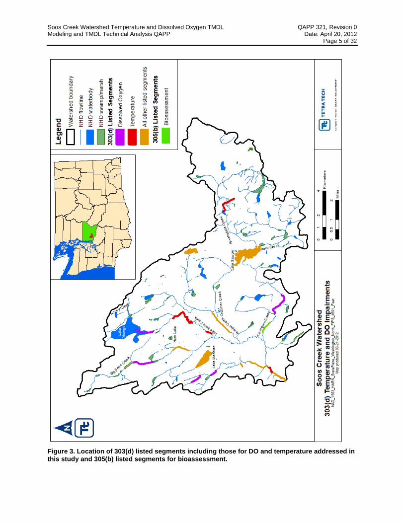
The Soos Creek watershed has 24 segments included as water quality impaired on the state’s 2008 303(d) list. The six DO listings occur on Big Soos Creek, Covington Creek, Little Soos Creek, and Little Soosette Creek. The four segments listed as impaired for temperature occur on Big Soos Creek, Little Soos Creek and Ravensdale Creek. Also, 13 segments are listed as impaired for fecal coliform bacteria and one segment impaired for total phosphorus. The overall system also has Category 2 (Waters of Concern) listings for pH, ammonia-N, bioassessment, and mercury. This TMDL addresses the impairment for DO, temperature (Figure 3) and aquatic habitat.
Basin land use consists of high-density residential and commercial development, agriculture/pasture, rural residential, and forest/forestry practices. In its comprehensive plan, King County has anticipated that substantial portions of the Soos Creek watershed will incorporate or urbanize (or both) by 2025 (King County 2008b). According to this plan, the current watershed population of approximately 112,000 people is likely to increase resulting in additional effects on surface waters.

Soos Creek Watershed Temperature and Dissolved Oxygen TMDL QAPP 321, Revision 0 Modeling and TMDL Technical Analysis QAPP Date: April 20, 2012 Page 4 of 32
Figure 2. Project location.
Soos Creek Watershed Temperature and Dissolved Oxygen TMDL QAPP 321, Revision 0 Modeling and TMDL Technical Analysis QAPP Date: April 20, 2012 Page 5 of 32
Figure 3. Location of 303(d) listed segments including those for DO and temperature addressed in this study and 305(b) listed segments for bioassessment.

Soos Creek Watershed Temperature and Dissolved Oxygen TMDL QAPP 321, Revision 0 Modeling and TMDL Technical Analysis QAPP Date: April 20, 2012 Page 6 of 32
Several types of NPDES permitted facilities or activities exist in the Soos Creek watershed. The most numerous is the construction stormwater general permit, with 45 active construction permits throughout the watershed. Construction permits primarily address the release of total suspended sediments into surface waters and associated increases in turbidity; however, the permits can also include limits on pH, nutrients, or other pollutant parameters.
King County and Washington Department of Transportation hold phase I municipal separate storm sewer system (MS4) permits in the watershed. Three communities (Covington, Black Diamond, and Maple Valley) hold phase II MS4 permits. Six sand and gravel general permits, three industrial stormwater general permits, one industrial individual permit, and two recycling general permits are in the watershed. Those permits do not stipulate limits for temperature, DO, or flow.
Since 1972 King County has been collecting water quality samples monthly at these four sites in the Soos Creek watershed: Soos Creek near the mouth, Covington Creek, Jenkins Creek near the mouth, and Little Soos Creek near the mouth. Beginning in 1987, sediment quality samples have been collected from Soos Creek. Benthic invertebrates were sampled in 2002, 2003, and 2006 at various locations in the watershed. Additionally, King County currently operates six stream flow gages (54a, 54h, 54i, 54j, 26a, and 09a) and five active precipitation gages (54v, 26u, 09v, KANG, and BDIA) and has historic records for two inactive precipitation gages (54w and 09u) in the system (King County 2009a).
In 2007 Ecology, King County, and others initiated a cooperative effort to develop a TMDL study for temperature and DO in the Soos Creek watershed. During the summer low-flow period (July–September), several water quality monitoring projects were conducted to collect short-term data on continuous temperature, continuous DO, synoptic productivity, and synoptic flow and travel time as outlined in the Sampling and Analysis Plan and Quality Assurance Project Plan–Soos Creek for DO and temperature (King County 2009b). Monitoring included in situ continuous data and instantaneous values and grab samples collected for laboratory analysis.
The objective of this pilot stormwater TMDL is to addresses the impairment to stream temperature, DO, and aquatic habitat caused predominantly by stormwater runoff. The results of this TMDL might include establishing load and wasteload allocations for impervious cover and/or use other surrogate measures such as bioassessment scores. “Bioassessment” is a measurement of biological and physical conditions at a stream location which when compared to expected conditions provides an indicator of the health of aquatic habitat conditions. In addition, the ‘stressors’ which contribute to the bioassessment results can often be identified and thereby provide direction for restoration activities needed to improve water quality and aquatic habitat. To meet this objective Tetra Tech has been tasked with the following:
• Conducting literature reviews to determine feasibility of developing targets for impervious surface allocations which can contribute to degradation of water quality and stream function. The review will evaluate examples or approaches for developing TMDLs for temperature, DO, and bioassessment by linking increased pollutant runoff, increased peak flows, degraded riparian conditions, and harmful channel alterations due to impervious surface in the watershed.
• Developing a linked Shade-HSPF-QUAL2Kw modeling system to assess temperature and DO conditions in the watershed and calculate allocations to improve water quality. This modeling system is composed of a geographical information system (GIS)-based Shade model linked to a QUAL2Kw water quality model and an HSPF watershed model to develop management options.
• Developing recommended TMDL wasteload and load allocations that will include impervious surface allocations that address temperature, DO, and bioassessment impairments.
Soos Creek Watershed Temperature and Dissolved Oxygen TMDL QAPP 321, Revision 0 Modeling and TMDL Technical Analysis QAPP Date: April 20, 2012 Page 7 of 32
Estimates of low flow during summer critical periods will be developed with assistance by MIT staff. Tetra Tech will perform the water quality modeling tasks in this project and incorporate bioassessment results to identify TMDL targets that if implemented will support designated beneficial uses for these waters. The bioassessment monitoring will be completed by Tetra Tech in a different technical directive and conducted under a different QAPP.
Addressing the principal study questions requires a modeling framework that can provide an interactive simulation of flow, upland nutrient and thermal loading, and in-stream oxygen demand and heating processes. The Shade model was selected to evaluate solar radiation along the stream using watershed specific GIS-based data derived with the tTools ArcView extension developed by Oregon Department of Environmental Quality (ODEQ). tTools uses polygon and grid coverages to determine vegetation and topography data perpendicular to the stream channel and longitudinal stream channel characteristics such as the near-stream disturbance zone and elevation. Typical input into tTools are LiDAR, digital elevation models (DEMs), and aerial imagery (digital orthophoto quadrangles and rectified aerial photos). Stream width, aspect, topographic shade angles, elevation, and riparian vegetation will be sampled with tTools for incorporation into the Shade model.
Ecology’s Shade model (Shade.xls—a Microsoft Excel spreadsheet available for download at http://www.ecy.wa.gov/programs/eap/models.html) was adapted from a program that ODEQ developed as part of its HeatSource model version 6. Shade.xls calculates the amount of shade using one of two methods. The first is Chen’s method, based on the FORTRAN program, HSPF SHADE. Y.D. Chen developed it for his 1996 Ph.D. dissertation at the University of Georgia (Chen 1996), and it is further documented in the Journal of Environmental Engineering (Chen 1998a, 1998b). The second method is ODEQ’s original method from the HeatSource model version 6. Documentation of ODEQ’s HeatSource model is at www.deq.state.or.us/wq/TMDLs/TMDLs.htm and www.heatsource.info. The Shade model quantifies the potential daily solar load and generates the percent effective shade. Effective shade is the fraction of shortwave solar radiation that does not reach the stream surface because vegetative cover and topography intercept it. Effective shade is influenced by latitude/longitude, time of year, stream geometry, topography, and vegetative buffer characteristics, such as height, width, overhang, and density.
The Shade model requires physical and vegetation parameters such as stream width, aspect, topographic shade angles, elevation, and riparian vegetation sampled using the tTools GIS extension. tTools output will be used as input for the Shade model to generate longitudinal effective shade profiles. Reach-averaged integrated hourly effective shade (i.e., the fraction of potential solar radiation blocked by topography and vegetation) will be used as input into the QUAL2Kw model, which is discussed later.
HSPF is a comprehensive, basin-scale and stream reach model that is capable of simulating hydrology, pollutant load generation, and fate and transport of pollutants in stream channels. It allows the integrated simulation of runoff processes and in-stream interactions and is capable of simulating subdaily dynamic time series of runoff and pollutant loads and concentration.
The original HSPF model for Soos Creek watershed was developed by King County. MIT will use this model to simulate hydrology in the Soos Creek watershed. MIT will refine the hydrology calibration, and it will create different impervious area scenarios. The model will be given to Tetra Tech for review and use in the Soos Creek TMDL as described in this QAPP. Before the HSPF model is used, Tetra Tech will review input parameters, along with calibration and validation (model corroboration) results to ensure that the HSPF hydrology model meets the specifications in this QAPP.
Tetra Tech will build on the hydrology simulation to complete an HSPF water quality application that can be used to support temperature and DO simulation in the Soos Creek watershed. The DO simulation could also require simulation of nutrients and algal growth. Tetra Tech will use the RQUAL functions (a module used to simulate behavior of constituents involved in biological transformations) in HSPF. Output from the HSPF model—including flow, water temperature (estimated using the HTRCH and SHADE-
Soos Creek Watershed Temperature and Dissolved Oxygen TMDL QAPP 321, Revision 0 Modeling and TMDL Technical Analysis QAPP Date: April 20, 2012 Page 8 of 32
HSPF modules), and water quality parameters—will be used to provide nonpoint boundary conditions to the QUAL2Kw water quality model. Point sources boundaries will be developed from permit and DMR data. The HSPF model will also be used to address potential habitat impacts of altered flow regimes under future scenarios.
Tetra Tech will calibrate the HSPF and QUAL2Kw water quality models in tandem. Parameter values obtained by calibrating and validating the QUAL2Kw model will be used to refine the temperature and DO representation in HSPF, while the updated HSPF model will be used to further refine the boundary conditions for QUAL2Kw.
The steady-state QUAL2Kw model will be used for detailed evaluation of temperature and water quality impacts in the Soos Creek watershed under critical flow and weather conditions. QUAL2Kw is a quasi-steady state model and is Ecology’s preferred tool for temperature and DO TMDLs. The model uses steady-state flow conditions and simulates water temperature and water quality parameters with diel variations. QUAL2Kw is well matched to the short-period, intensive/continuous monitoring work conducted on the creek. QUAL2Kw will be used to address specific specialized processes (e.g., hyporheic flow).
Tetra Tech will use QUAL2Kw to conduct focused analysis of critical conditions (i.e., low flow, high temperature) from which TMDL targets can be determined directly. For QUAL2Kw calibration and validation, observed flow, temperature, and water quality parameters will be used if available. If such data are not available, results from calibrated HSPF model will be used. Model inputs for various management scenarios will be from the basin-scale HSPF model. The QUAL2Kw model will be used for evaluating TMDL loading capacity and developing allocations under critical conditions, including evaluation of MIT’s projected critical season low stream flow under various impervious cover scenarios determined by the Soos Creek team. Calibration of the QUAL2Kw model to intensively monitored events will also be used to refine parameters for the heat and DO simulations in the watershed-scale HSPF water quality model.
Meteorological conditions have strong influences on water temperature. Parameters included in QUAL2Kw input that affect stream temperature are effective shade, solar radiation, air temperature, cloud cover, relative humidity, and headwater temperature. These parameters are calculated (e.g., effective shade from Shade model) or obtained from weather station information. Stream temperature is also affected by point source effluent temperatures, which will be obtained from discharge monitoring report (DMR) data, where available. These factors will be specified or simulated on an hourly time scale.
This QAPP addresses only the Tetra Tech modeling task (Task 3 below), as the literature search (Task 2), development of selected TMDL report sections (Task 4), and assistance with development of materials for the public notice process, comment response, and revision of the modeling and technical approach descriptions in the TMDL documents (Task 5) do not entail specific QC requirements.
1.3 PROJECT/TASK DESCRIPTION The analysis and modeling work that is the subject of this QAPP is described in Task 3 of the technical directive issued under task order 0088 of contract EP-C-08-002. The modeling task requires coordination with the local authorities (Ecology and the MIT), as concurrent HSPF modeling work is being conducted in King County by the MIT. The following subtasks are included in this project:
1. Project Administration. Tetra Tech will coordinate and facilitate project communication with the Soos Creek Project Team (Team), which includes representatives from EPA, Ecology, MIT, and, occasionally with the local water agencies of the cities of Black Diamond, Covington, Kent and Maple Valley and King County.

Soos Creek Watershed Temperature and Dissolved Oxygen TMDL QAPP 321, Revision 0 Modeling and TMDL Technical Analysis QAPP Date: April 20, 2012 Page 9 of 32
a. Tetra Tech will coordinate a kickoff call and subsequent calls with the Team to discuss the background, scope, goals, schedule, and projected outcomes and outputs. After the kickoff call, Tetra Tech will prepare summarized highlights including key discussion points, outcomes, and action items from the call.
b. Tetra Tech will coordinate conference calls with Team members (specified by EPA) whenever draft work products are available for review and prepare summarized highlights of each of the subsequent calls. After a deliverable is submitted, Tetra Tech will allow for a 2-week EPA, state, and stakeholder review and comment period. Tetra Tech will set up a conference call, using a Doodle poll, to discuss the deliverable.
2. Determine Feasibility of Impervious Surface Allocations for Temperature, DO, and Aquatic Life (Impairments). Tetra Tech will complete literature searches and reviews to summarize methods/processes related to developing impervious surface allocations in TMDLs. These examples along with more traditional approaches for addressing DO, temperature, and biological impairment will be considered for developing a TMDL for the Soos Creek watershed. The literature searches will be limited to review and feasibility assessment, and will build on, but not duplicate, ongoing efforts by MIT, which include hydrology modeling scenarios in HSPF to assess the impacts of impervious surfaces.
a. Feasibility assessments
i. Tetra Tech will explore the feasibility of linking decreased baseflows to increased impervious surface and basin water management (withdrawal and return) to summer stream temperature and DO impairments.
ii. Tetra Tech will determine the feasibility of linking increased pollutant loads, peak flows, and channel alterations due to increased impervious surface areas to DO and bioassessment impairments.
b. Tetra Tech will draft a memorandum describing the results of the feasibility assessments and make recommendations of an approach to develop impervious surface allocations for the Soos Creek TMDL. Tetra Tech will organize a conference call to discuss the findings with the Team and will incorporate comments and recommendations of the Team in its final memorandum. Tetra Tech will use the information in the memorandum to develop meaningful allocations, for example, impervious cover, flow, or biological targets.
3. TMDL Modeling and Technical Analysis. Under Task 3 of the technical directive, Tetra Tech will do the following:
a. Assemble and inventory all available data provided by the Team and prepare a summary of data received and data gaps (data still needed to complete subsequent modeling and analyses).
b. Attend a site visit with the Team to the Soos Creek watershed (April 25 & 26) and prepare a modeling QAPP (this document) for the mutually agreed upon models for review and approval before developing (or using) the identified models.
c. Model the existing Soos Creek watershed using the HSPF model initially developed by King County and modified by MIT.
d. Develop an HSPF model and QUAL2Kw modeling analysis of temperature and DO for the system, and the Team will provide feedback and guidance regarding the model and technical approach.
Soos Creek Watershed Temperature and Dissolved Oxygen TMDL QAPP 321, Revision 0 Modeling and TMDL Technical Analysis QAPP Date: April 20, 2012 Page 10 of 32
i. The model will include all stream subbasins for which data were collected during the 2007 data collection program including models for Big Soos, Little Soos, Jenkins, and Covington creeks.
ii. Tetra Tech will model the following scenarios:
1. Current condition using a calibration period for temperature determined as the warmest average 7-day period of the 2007 sampling year and validation determined as the second warmest average 7-day period. Current conditions and validation period for DO modeling will coincide with the 2 synoptic surveys conducted during 2007 sampling.
2. Critical low-flow and weather condition (7Q10 flows [the lowest 7-day average flow that occurs on average once every 10 years] and 90th percentile weather conditions [air temperature, dew point temperature and wind speed]).
3. For establishing recommended load allocations (LAs) and wasteload allocations (WLAs), several different management scenarios proposed by the Team. Depending on the results of the impervious surface allocations task (Task 2), one of the management scenarios could include baseflow estimates for various impervious surface and water withdrawal scenarios derived by the MIT staff using King County’s HSPF model for the system.
e. Develop a draft TMDL report (with the exception of the implementation plan) using the template and examples provided by the Team. The draft TMDL report will be delivered in sections to expedite Team decisions and the review process. Specifically, Tetra Tech will develop draft TMDL sections describing the Analytical Approach and Findings, and it will include a description of the modeling approach, assumptions, limitations, and results. After the Team reviews and comments on the sections, Tetra Tech will compile a written response to comments and revise and finalize the TMDL report sections according to the comments received and corrective measures agreed to in collaboration with the Team.
f. Tetra Tech will provide all data and model input files used for developing the draft TMDL report to Ecology, EPA and MIT.
4. TMDL Wasteload, Load Allocations, Margin of Safety and Reasonable Assurance. Tetra Tech will develop draft report sections for the following parts of the TMDL report:
a. Loading capacity.
b. WLAs for point sources expressed as numeric daily loads to address temperature and DO impairments. The WLAs will include numeric or programmatic targets (e.g., via impervious cover, flow and/or bioassessment) to meet the temperature and DO criteria as well as support aquatic life uses. Recommended WLAs will be developed for all permitted point sources in the basin, including stormwater, sand and gravel, hatchery, and the like.
c. LAs for nonpoint sources in the basin consisting of numeric targets to meet the temperature and DO criteria. LAs will be calculated for individual sectors (e.g., land use types), and could include percent impervious surface goals.
d. Margin of safety, describing assumptions made during modeling.

Soos Creek Watershed Temperature and Dissolved Oxygen TMDL QAPP 321, Revision 0 Modeling and TMDL Technical Analysis QAPP Date: April 20, 2012 Page 11 of 32
e. Seasonal variation and critical conditions describing how the modeling approach addresses each.
f. Recommended implementation options for attainment, including percent imperviousness reductions, improving riparian shade, nutrient load reductions, recommendations for low impact development approaches, bioassessment targets at compliance points in the watershed, and best management practices including monitoring requirements identifying specific locations and frequency and an analysis linking best management practices to the impairments, improvements, costs, and expected effectiveness as they relate to temperature and DO.
g. Reasonable assurance description incorporating the elements of Ecology’s standard components of reasonable assurance based on an approved TMDL example selected and provided by the Team. The discussion may include descriptions of the process used to estimate the recommended nonpoint source load and WLAs by sector and assumption applied to estimate the expected reductions (e.g., number and type of best management practices and their associated efficiencies).
5. Soos Creek Temperature and DO TMDL for public notice. Tetra Tech will provide technical assistance during the public notice period to help finalize the TMDL, including preparing graphic aids describing the technical approach for presentation or inclusion in the TMDL fact sheet, and revising the model/technical approach descriptions in the TMDL document according to comments, if appropriate.
1.4 QUALITY OBJECTIVES AND CRITERIA FOR MODEL INPUTS/OUTPUTS This section describes the quality objectives for the project and the general performance criteria to achieve those objectives. Specific quantitative tests are described further in Section 2.
EPA policy is to use a systematic planning process to define quality objectives and performance criteria. Systematic planning identifies the expected outcome of the modeling project, its technical goals, cost and schedule, and the criteria for determining whether the inputs and outputs of the various intermediate stages of the project, and the project’s final product, are acceptable.
The Soos Creek TMDL modeling and technical analyses are being planned consistent with EPA’s DQO Process. A key component of the DQO Process is identifying and documenting the decision context for the project (the principal study questions). The general quality objectives for modeling are to provide information sufficient to answer each of the principal study questions, which are described below for this project.
The quality of an environmental analysis program can be evaluated in three steps: (1) establishing scientific assessment quality objectives, (2) evaluating program design for whether the objectives can be met, and (3) establishing assessment and measurement quality objectives that can be used to evaluate the appropriateness of the methods used in the program.
Sections 1.4.1 through 1.4.6 describe DQOs and criteria for TMDL development for this project, written in accordance with the seven steps described in EPA’s Guidance for the Data Quality Objectives Process (EPA QA/G-4) (USEPA 2006a).
1.4.1 State the Problem Ecology has 24 segments of the Soos Creek watershed listed as water quality impaired on the state’s 2008 303(d) list that require development of TMDLs. Among the 24 listed segments are 6 DO listings on Big Soos, Covington, Little Soos, and Little Soosette creeks and 4 segments listed as impaired for temperature

Soos Creek Watershed Temperature and Dissolved Oxygen TMDL QAPP 321, Revision 0 Modeling and TMDL Technical Analysis QAPP Date: April 20, 2012 Page 12 of 32
on Big Soos, Little Soos, and Ravensdale creeks. The remaining segments are listed for fecal coliform bacteria and phosphorus, which although outside the scope of this project the anticipated targets for riparian vegetation, DO, and stormwater runoff may also reduce these pollutants such that they no longer violate water quality standards. The beneficial uses protected in the Soos Creek watershed are core summer rearing habitat for salmonids. Portions of Big Soos, Jenkins, and Covington creeks require supplemental protection for spawning and incubation of salmonids. The applicable temperature criterion for salmonid rearing is a 7-DADMAX temperature that must not exceed 16 °C. The supplemental spawning and incubation requirements dictate additional requirements during the period of the year when spawning and incubation are occurring (September 15 to July 1), during which the 7-DADMAX temperatures must not exceed 13 °C. If temperatures are naturally occurring above these criteria, human actions considered cumulatively must not cause the 7-DADMAX temperature of that waterbody to increase more than 0.3 °C. When the background condition of the water is cooler than the criteria, incremental temperature increases resulting from individual point source activities must not, at any time, exceed 28/(T + 7) as measured at the edge of a mixing zone boundary (where T represents the background temperature as measured at a point or points unaffected by the discharge and representative of the highest ambient water temperature in the vicinity of the discharge), and incremental temperature increases resulting from the combined effect of all nonpoint source activities in the waterbody must not, at any time, exceed 2.8 °C. Such incremental increases must not exceed the prevailing temperature criteria. Water temperatures should not exceed these criteria at a probability frequency of more than once every 10 years.
For both the salmonid rearing and the spawning and incubation use categories, DO must remain above 9.5 mg/L. DO concentrations should not drop below these criteria at a probability frequency of more than once every 10 years. If DO concentrations are naturally below these criteria, human influences should not cause an additional decrease of more than 0.2 mg/L.
A description of available monitoring data and other information is being provided in a separate deliverable under this technical directive. Depressed DO and increased temperatures in Soos Creek occur as a result of a series of complex processes. The DO and temperature impairment are suspected to be the net result of increases in impervious surface which affect base flow, nutrient and sediment loadings, and loss of mature riparian vegetation throughout the watershed. As such, the current modeling framework and TMDL are focused on potential impacts and benefits of management of impervious surface, informing future water resource management decisions relative to stormwater discharges, groundwater recharge, restoration of riparian vegetation and reduced loading of sediment and nutrients to the Soos Creek watershed.
In sum, the principal study questions to be addressed in this project are
1. What is the feasibility of incorporating impervious surface allocations into TMDLs for temperature, DO, and bioassessment by linking increased pollutant runoff, peak flows, and channel alterations from increased impervious surface to temperature, DO, and bioassessment impairments?
2. What are the sources of decreased DO and increased temperature and impaired aquatic life habitat in the Soos Creek watershed during critical summer, low-flow conditions?
3. What are the TMDL allocations—such as riparian shade, nutrients, impervious area, flow, or biological targets—needed in the Soos Creek watershed to meet temperature and DO standards?
4. What are the stressors affecting the ability of Soos Creek to fully support designated uses? Is it feasible to determine biological targets that represent full support of designate aquatic uses at compliance points or for effectiveness monitoring?

Soos Creek Watershed Temperature and Dissolved Oxygen TMDL QAPP 321, Revision 0 Modeling and TMDL Technical Analysis QAPP Date: April 20, 2012 Page 13 of 32
1.4.2 Identify the Decision The intended end product of this task order is TMDLs for temperature and DO in the Soos Creek watershed. The watershed simulation models provide the ability to evaluate the relative benefit of different management alternatives that might limit impervious surface and enhance riparian cover. The Team (EPA, Ecology, MIT, and Tetra Tech) will determine management alternatives and it will consider them for TMDL allocations.
1.4.3 Identify the Inputs to the Decision The Shade, QUAL2Kw, and HSPF model framework developed as a result of this task order will be used to evaluate potential management scenarios in addition to DO and temperature TMDLs. The model will provide decision-related inputs on the impacts of these scenarios on total flows and nutrient loading to Soos Creek from both upland and in-stream sources and from potential riparian vegetative cover options.
1.4.4 Define the Boundaries of the Study The focus of the study is the impaired segments of Big Soos, Covington, Little Soos, Little Soosette, and Ravensdale creeks; however, conditions in the impaired segments are largely determined by loads derived from the contributing watershed. The boundaries of the study are thus generally coincident with the extent of the Soos Creek watershed, which occupies approximately 70 square miles of glacial deposits, foothill ridges, and flat valley land (Figure 2).
1.4.5 Develop a Decision Rule for Information Synthesis The purpose of a decision rule is to integrate the outputs from the study into a single statement that describes the logical basis for choosing among alternative actions. Output from the previous DQO steps will be used to guide decision makers to choose from among alternative actions. The model described in this QAPP will be applied in the context of a larger stakeholder process and management scenarios. The overall decision rule relative to the HSPF model is
To support uses in Soos Creek it is necessary to control a variety of factors that contribute—either directly or indirectly—to elevated temperatures and decreased DO. A watershed model that is capable of evaluating flow, upland nutrient sources, and in-stream processes will be used to evaluate the contributions of different sources to current conditions and to determine load reductions necessary to achieve standards. The evaluation of the sensitivity and importance of different stressor sources will be used to identify, evaluate, and test potential implementation strategies to reduce temperature and increase DO in Soos Creek. The modeling described in this QAPP will be used to provide evaluations of the potential benefits of candidate management strategies that will be developed by the Team.
1.4.6 Specify Tolerance Limits on Decision Errors To help guide the interpretation of the technical information provided by the water quality model, general performance targets for the modeling are described in Section 2.2.4. The performance targets are based on generally accepted values from the literature and Tetra Tech staff experience with previous projects.
Specific numeric acceptance criteria are not specified for the model. Instead, appropriate uses of the model will be determined by the project team after assessing the types of decisions to be made, the model performance, and the available resources.

Soos Creek Watershed Temperature and Dissolved Oxygen TMDL QAPP 321, Revision 0 Modeling and TMDL Technical Analysis QAPP Date: April 20, 2012 Page 14 of 32
1.5 SPECIAL TRAINING REQUIREMENTS/CERTIFICATION Tetra Tech staff members involved in developing model input data sets and model application have experience in numerical modeling gained through their work on numerous similar projects. The Tetra Tech TOL, Mark Sievers, who has extensive experience managing similar projects, will provide guidance to the modeling. The TOL will ensure strict adherence to the project protocols.
The Tetra Tech TOL will oversee the project team in its execution of key project objectives. Dr. Sen Bai, P.E., the modeling lead, and Dr. Jonathan Butcher, the modeling QC officer will primarily assist the TOL.
Dr. Bai is an environmental engineer providing technical and project management support in the areas of watershed modeling, hydrodynamic and water quality modeling, linked watershed-receiving water modeling, and TMDL development. Dr. Bai has served as lead modeler for more than 20 waterbodies and watersheds, including lakes, rivers, and reservoirs using CE-QUAL-W2, EFDC, WASP, LA-QUAL, GWLF, LSPC, and HSPF.
Dr. Jonathan Butcher, P.H., is a water quality modeler and Professional Hydrologist (American Institute of Hydrology) with more than 25 years’ experience supporting EPA, state, and local governments throughout the United States in TMDL and water supply protection studies. He is a nationally recognized expert in the application of the watershed and waterbody response models.
Mr. John O’Donnell, the QA officer for this project, is the QA manager for Tetra Tech’s Fairfax Center offices. He has more than 20 years of environmental laboratory and QA experience and has been QA officer for several contracts in the past, including EPA contracts with the Office of Science and Technology; Office of Wastewater Management; and Office of Wetlands, Oceans, and Watersheds.
1.6 DOCUMENTATION AND RECORDS Thorough documentation of all modeling activities is necessary to be able to effectively interpret the results. All records and documents relevant to the application, including electronic versions of data and input data sets, will be maintained at Tetra Tech’s offices in the central file. The central repository for the modeling work will be Tetra Tech’s Fairfax, Virginia, office. Tetra Tech will deliver a copy of the records and documents in the central file to EPA Region 10 at the end of the task. Unless other arrangements are made, records will be maintained at Tetra Tech’s offices for a minimum of 3 years after task completion.
The Tetra Tech TOL and designees will maintain files, as appropriate, as repositories for information and data used in models and for preparing reports and documents during the task. Electronic project files are maintained on network computers and are backed up weekly. The Tetra Tech TOL will supervise the use of materials in the central files. The following information will be included in the hard copy or electronic task files in the central file:
• Any reports and documents prepared
• Contract and task order information
• QAPP and draft and final versions of requirements and design documents
• Electronic copies of models
• Results of technical reviews, internal and external design tests, quality assessments of output data, and audits
• Documentation of response actions during the task to correct problems
• Input and test data sets

Soos Creek Watershed Temperature and Dissolved Oxygen TMDL QAPP 321, Revision 0 Modeling and TMDL Technical Analysis QAPP Date: April 20, 2012 Page 15 of 32
• Communications (memoranda; internal notes, telephone conversation records, letters, meeting minutes, and all written correspondence among the task team personnel, suppliers, or others)
• Studies, reports, documents, and newspaper articles pertaining to the task
• Special data compilations
Records of receipt with information on source and description of documentation will be filed along with the original data sheets and files to ensure traceability. Records of actions and subsequent findings will be kept during additional data processing.
All data files, source codes, and executable versions of the computer software will be retained for internal peer review, auditing, or post-task reuse in the electronic task files in the administrative record. These materials include the following:
• Versions of the source and executable code used
• Databases used for model input, as necessary
• Key assumptions
• Documentation of the model code and verification testing for newly developed codes or modifications to the existing model
The Tetra Tech modeling QC officer and other experienced technical staff will review the materials listed above during internal peer review of modified existing models or new codes or models. The designated QC officers will perform QC checks on any modifications to the source code used in the design process. All new input and output files, together with existing files, records, codes, and data sets, will be saved for inspection and possible reuse.
Any changes in this QAPP required during the study will be documented in a memo sent by Tetra Tech’s QA officer to each person on the distribution list following approval by the appropriate persons. The memo will be attached to the revised QAPP.
All methods, assumptions, etc. will be documented in a final memorandum detailing the modeling process and conclusions, as required by the task order.

Soos Creek Watershed Temperature and Dissolved Oxygen TMDL QAPP 321, Revision 0 Modeling and TMDL Technical Analysis QAPP Date: April 20, 2012 Page 16 of 32
2 Model Selection, Calibration, and Supporting Data Acquisition and Management
2.1 MODEL SELECTION The work described in this QAPP does not involve creating new simulation modeling software. Rather, it involves developing and applying existing models—Shade, HSPF, and QUAL2Kw.
2.2 MODEL CALIBRATION AND VALIDATION Environmental simulation models are simplified mathematical representations of complex real-world systems. Models cannot accurately depict the multitude of processes occurring at all physical and temporal scales. Models can, however, make use of known interrelationships among variables to predict how a given quantity or variable would change in response to a change in an interdependent variable or forcing function. In this way, models can be useful frameworks for investigating how a system would likely respond to a perturbation from its current state. To provide a credible basis for predicting and evaluating mitigation options, the ability of the model to represent real-world conditions should be demonstrated through a process of model calibration and corroboration (CREM 2009).
2.2.1 Objectives of Model Calibration Activities Model calibration is designed to ensure that the model is adequate to provide appropriate input to answer the study questions. The objective of this TMDL is to develop an innovative temperature and DO TMDL that includes stormwater WLAs and LAs via impervious cover or flow. Below are the principal study questions to be addressed by modeling in this project.
1. What is the feasibility of incorporating impervious surface allocations into TMDLs for temperature, DO, and bioassessment by linking increased pollutant runoff, peak and low flows, and channel alterations with the existing and projected amounts of impervious surface in the watershed?
2. What are the sources/causes of decreased DO and increased temperature and impaired aquatic life habitat in the Soos Creek watershed during critical summer low flow conditions?
3. What are the TMDL allocations—such as riparian shade, nutrients, impervious area, flow, or biological targets—needed in the Soos Creek watershed to meet temperature and DO standards?
4. What are the stressors affecting the ability of Soos Creek to fully support designated uses? Is it feasible to determine biological targets that represent full support of designate aquatic uses at compliance points or for effectiveness monitoring?
To address those questions, the models must be able to provide credible representations of (1) water movement and (2) thermal and pollutant load generation and transport.
2.2.2 Model Calibration/Validation Procedures Calibration consists of the process of adjusting model parameters to provide a match to observed conditions. Calibration is necessary because of the semi-empirical nature of water quality models. Although these models are formulated from mass balance principles, most of the kinetic descriptions in

Soos Creek Watershed Temperature and Dissolved Oxygen TMDL QAPP 321, Revision 0 Modeling and TMDL Technical Analysis QAPP Date: April 20, 2012 Page 17 of 32
the models are empirically derived. These empirical derivations contain a number of coefficients that are usually determined by calibration to data collected in the waterbody of interest.
Calibration tunes the models to represent conditions appropriate to the waterbody and watershed being studied. However, calibration alone is not sufficient to evaluate the predictive capability of the model or to determine whether the model developed via calibration contains a valid representation of cause and effect relationships. To help determine the adequacy of the calibration and to evaluate the uncertainty associated with the calibration, the model is subjected to a corroboration step. In the corroboration step, the model performance is assessed on a set of data separate from that used in calibration.
The Soos Creek model will be calibrated and validated through a sequential process, beginning with hydrology (by MIT for HSPF and Tetra Tech for QUAL2Kw), followed by the water quality (by Tetra Tech). Hydrologic calibration will use standard operating procedures. Those are described for the HSPF model in BASINS Technical Note 6 on Estimating Hydrology and Hydraulic Parameters for HSPF (USEPA 2000). HSPF modeling will build on work conducted by King County with additional scenarios developed by MIT.
MIT will calibrate the hydrology modeling for HSPF, and Tetra Tech will review it. While, MIT is not bound by this QAPP, EPA expects that the HSPF hydrology model will meet EPA quality objectives. The MIT model will evaluate the effects of impervious surfaces and other land use changes on base flow in the Soos Creek system. The impacts of these land use changes will be quantified by comparing simulated base flows under impacted conditions with simulated base flows from undeveloped conditions with no impervious surfaces in the basin. MIT Staff will estimate base flow reductions due to groundwater and surface water withdrawals. The Tetra Tech review of the HSPF hydrology model will include verifying that all model inputs are within literature acceptable ranges. Model output will be compared to, among other things, the annual water balance, low/high flow distribution, storm peaks, and hydrograph shape. It is expected that during hydrology calibration, land segment hydrology parameters will be adjusted iteratively to achieve agreement between simulated and observed stream flows at specified locations throughout the basin. Because the temperature and DO impairments occur in low-flow periods for both water temperature and DO, the calibration will be emphasized in the low-flow simulation. Agreement between observed and simulated stream flow data are evaluated on annual and seasonal bases using quantitative and qualitative measures. Specifically, annual water balance, groundwater volumes and recession rates, and surface runoff and interflow volumes and timing are evaluated, along with composite comparisons (e.g., average monthly stream flow values over the period of record). If the MIT HSPF hydrology model does not meet EPA quality objectives, Tetra Tech will notify EPA to determine if additional calibration is necessary. Alternatively, MIT will document the reasons why certain objectives cannot be achieved.
After calibration for hydrology of HSPF, the hydrology in QUAL2Kw will be calibrated by Tetra Tech. The simulated water balance is determined almost entirely by boundary conditions, which will be specified on the basis of best available data. The calibration of hydrology in QUAL2Kw is focused on ensuring that depths, flow velocities, and travel times are well represented in the model.
After completing the calibrations of hydrology for both HSPF and QUAL2Kw, Tetra Tech will calibrate the HSPF and QUAL2Kw models for water quality. Water quality parameters are simulated in both HSPF and QUAL2Kw. HSPF will simulate water temperature, DO, nutrients, and algae using the RQUAL function continuously for the same period as the hydrology calibration. Calibration of HSPF water quality parameters will rely mainly on a qualitative visual inspection of hydrograph peaks, etc.
Tetra Tech will perform calibration for temperature and DO in the QUAL2Kw model. The QUAL2Kw model uses steady-state flow; the observed DO is not sensitive to flow but is sensitive to temperature. Therefore, steady-state analyses at typical summer baseflow conditions will be appropriate. Tetra Tech

Soos Creek Watershed Temperature and Dissolved Oxygen TMDL QAPP 321, Revision 0 Modeling and TMDL Technical Analysis QAPP Date: April 20, 2012 Page 18 of 32
will identify periods of relatively intensive data availability from the existing monitoring record for calibration, corroboration, and potential further testing of the model performance.
The QUA2Kw will be calibrated through a sequential process, beginning with water temperature, followed by chemical water quality and algal/macrophyte response. The temperature simulation will depend on boundary conditions and riparian shading. The water quality calibration will begin by attaining a general representation of total nitrogen and total phosphorus concentrations. That will be followed by calibration for nutrient species, which must be done simultaneously with model development of macrophyte/benthic algae growth. DO calibration will then occur as the final step, because the DO balance depends on all the other components of the calibration.
For this project, Tetra Tech will use both visual inspection and statistics comparing observed and modeled data when continuous data are available. When continuous data are not available, visual inspection will be the main approach to determine if calibration/validation are sufficient. A two-stage approach will be used for water quality calibration. In the first stage, the model calibration will be guided by a visual comparison approach aimed at reproducing the trend and overall dynamics of the system. After the model has been calibrated to the trend and overall dynamics, the second stage involves fine tuning the parameters and then calculating various error statistics to find the most appropriate calibration within the range of state spaces found in stage one for the locations with sufficient data.
After the model is adequately calibrated, the quality of the calibration will be evaluated through corroboration tests on separate data. This process is often referred to as model validation, defined as, “subsequent testing of a pre-calibrated model to additional field data, usually under different external conditions, to further examine the model’s ability to predict future conditions” (USEPA 1997). Its purpose is to ensure that the calibrated model properly assesses all the variables and conditions that can affect model results and demonstrate the ability to predict field observations for periods separate from the calibration effort. That helps to ensure that the model of the system is robust and that the quality of the calibration is not an artifact of over-fitting to a specific set of observations, which can occur because of the persistence of the effects of high-precipitation events on water storage in the model. Validation also provides a direct measure of the degree of uncertainty that can be expected when the model is applied to conditions outside the calibration series. For HSPF, the model runs continuously and covers different wet and dry conditions. Therefore, calibration and validation will be combined. Because QUAL2Kw can represent conditions for only one day with steady-state flow and diel water quality, another set of data is needed for model validation. During model validation, the kinetics-related rates and constants obtained from calibration will be applied to the validation data set. These rates and constants will be adjusted iteratively until model calibration and validation results both agree well with the different data sets.
To conduct the calibration and corroboration process, a qualitative graphical comparison and set of basic statistical methods will be used to compare model predictions and observations, including the mean error statistic, the absolute mean error, the root-mean-square error, the relative error, the coefficient of determination, and the Nash-Sutcliffe coefficient (ENS) of model fit efficiency for time series data. Because QUAL2Kw is a steady-state (diurnal) model, other statistics that are commonly applied to dynamic models, such as the coefficient of determination, and the Nash-Sutcliffe coefficient of model fit efficiency, will not be applied here. While each of those statistics will be reported, model acceptance criteria are defined on a specific subset of these measures, as described in Section 2.2.4.
Mean Error Statistic. The mean error between model predictions and observations is defined as
nPO
E ∑ −=
)(,
where

Soos Creek Watershed Temperature and Dissolved Oxygen TMDL QAPP 321, Revision 0 Modeling and TMDL Technical Analysis QAPP Date: April 20, 2012 Page 19 of 32
E = mean error
O = observations
P = model prediction at the same time as the observations
n = number of observed-predicted pairs
A mean error of zero is ideal. A non-zero value is an indication that the model might be biased toward either over- or under-prediction. However, an important consideration of the mean error approach is that it can severely penalize the model for small phase shifts in timing. One approach that can be used to address this is to establish a time window, calculate the range of model predictions for the time window, then count a deviation from prediction only if the observation falls outside this range.
Absolute Mean Error Statistic. The absolute mean error between model predictions and observations is defined as
nPO
Eabs∑ −
=)(
,
where
Eabs = absolute mean error.
An absolute mean error of zero is ideal. The magnitude of the absolute mean error indicates the average deviation between model predictions and observed data. Unlike the mean error, the absolute mean error cannot give a false zero.
Root-Mean-Square Error Statistic. The root-mean-square error (Erms) is defined as
nPO
Erms∑ −
=2)(
.
A root-mean-square error of zero is ideal. The root-mean-square error is an indicator of the deviation between model predictions and observations. The Erms statistic is an alternative to (and is usually larger than) the absolute mean error.
Relative Error Statistics. The relative error statistics (RE) between model predictions and observations is calculated by dividing the mean error and absolute mean error statistics by the mean of the observations. A relative error statistic of zero is ideal. When it is non-zero, it represents the percentage of deviation between the model prediction and observation.
Coefficient of Determination. The coefficient of determination (R2) is the squared version of the correlation coefficient (R) defined as
( ) ( )( ) ( ) ∑ ∑
∑∑∑
⋅
⋅=
−⋅−
−⋅−=
2222ii
ii
ii
ii
PO
PO
PPOO
PPOOR ,
where the overbar indicates the mean of the observed values. The coefficient of determination varies between 0 and 1 and indicates the proportion of the total variation in observations explained by the model.
Nash-Sutcliffe Coefficient of Model Fit Efficiency. The coefficient of model fit efficiency or Nash-Sutcliffe coefficient (ENS) is particularly useful for evaluating model fit to continuous data, taking into account both the difference between model and observation and the variance of the observations. The statistic is defined as

Soos Creek Watershed Temperature and Dissolved Oxygen TMDL QAPP 321, Revision 0 Modeling and TMDL Technical Analysis QAPP Date: April 20, 2012 Page 20 of 32
( )
( )∑
∑
=
=
−
−−= n
ii
n
iii
NS
OO
POE
1
2
1
2
0.1 .
The resulting coefficient ranges from minus infinity to 1.0, with higher values indicating better agreement. At a value of zero, the test indicates that the observed mean is as good a predictor as the model, while negative values indicate that the observed mean is a better predictor than the model.
2.2.3 Numeric Guidance for Acceptance of Model Calibration The intended uses of the model focus on the effectiveness and cost-effectiveness of different implementation strategies. As such, the ability of the models to represent the relative contributions of different source areas and the relative performance of different management measures is of greatest importance, while obtaining a precise estimate of loading time series is of less direct interest. Ideally, the models should attain tight calibration to observed data; however, a less precise calibration can still be useful.
In light of these uses of the models, it is most informative to specify performance target ranges of precision that characterize the model results as very good, good, fair, or poor. These characterizations inform appropriate uses of the model: Where a model achieves an excellent fit it can assume a strong role in evaluating management options. Conversely, where a model achieves only a fair or poor fit it should assume a much less prominent role in the overall weight-of-evidence evaluation of management options.
The general acceptance criterion for models to be applied in this project is to achieve a quality of fit of good or better. If that level of quality is not achieved on some or all measures, the model might still be useful; however, a detailed description of its potential range of applicability will be provided, as described in Section 4.1. These criteria should be used as evidence of the quality of fit, but other factors such as qualitative measures should be considered by the Team in regards to the acceptability of the model calibration.
2.2.4 Model Evaluation of HSPF and QUAL2Kw For HSPF hydrologic models, a variety of performance targets have been specified, including Donigian et al. (1984), Lumb et al. (1994), and Donigian (2000). On the basis of these publications and previous experience with the model, the HSPF performance targets for simulation of the water balance components are summarized inTable 2-1. As noted in Section 2.2.3, model performance will be deemed acceptable where a performance evaluation of good or very good is attained. Note that various factors can contribute to poor statistics. For hydrology simulation, precipitation and evapotranspiration are the major driving forces. Yet the spatial variations are high, especially for precipitation. Other factors such as unique geology and groundwater system can also contribute to poor calibration. The statistics should be used with visual inspection to evaluate the model performances.
Because QUAL2Kw uses steady-state flow, only one flow condition can be considered for one model run. For model calibration and validation, two modeled results will be output. The flow balance of QUAL2Kw is mainly governed by specified boundary inflows. No statistics will be calculated for flow. For other parameters such as velocity, statistics can be calculated if data are available. Statistics become meaningful when sufficient data are available. It is not expected that sufficient data will be available for the QUAL2Kw hydrology calibration. The statistics must be used cautiously in combination with visual inspection.

Soos Creek Watershed Temperature and Dissolved Oxygen TMDL QAPP 321, Revision 0 Modeling and TMDL Technical Analysis QAPP Date: April 20, 2012 Page 21 of 32
Table 2-1. Performance targets for HSPF hydrologic simulation
Model component Very good Good Fair Poor
1. Error in total volume ≤ 5% 5%–10% 10%–15% > 15%
2. Error in 50% lowest flow volumes ≤ 10% 10%–15% 15%–25% > 25%
3. Error in 10% highest flow volumes ≤ 10% 10%–15% 15%–25% > 25%
4. Error in storm volume ≤ 10% 10%–15% 15%–25% > 25%
5. Winter volume error ≤ 15% 15%–30% 30%–50% > 50%
6. Spring volume error ≤ 15% 15%–30% 30%–50% > 50%
7. Summer volume error ≤ 15% 15%–30% 30%–50% > 50%
8. Fall volume error ≤ 15% 15%–30% 30%–50% > 50%
9. R2 daily values > 0.80 > 0.70 > 0.60 ≤ 0.60
10. R2 monthly values > 0.85 > 0.75 > 0.65 ≤ 0.65
It is important to clarify that the tolerance ranges are intended to be applied to mean values and that individual events or observations can show larger differences and still be acceptable (Donigian 2000).
General performance targets for water quality simulation with HSPF are also provided by Donigian (2000) and are shown in Table 2-2. These are calculated from observed and simulated daily values, and should be applied only in cases with a minimum of 20 observations. Unlike flow, water quality parameters are not observed continuously. The HSPF calibration must therefore rely on comparison of continuous model output to point-in-time-and-space observations. This creates a situation in which it is not possible to fully separate error in the model from variability inherent in the observations. For example, a model could provide an accurate representation of an event mean or daily average concentration in a reach, but an individual observation at one time and one point in a reach itself could differ significantly from the average. In addition, any uncertainty present in the hydrologic calibration will also propagate into the water quality simulation. Data collection itself often cannot capture the peak values. Loading information can also consist of average values (for example, monthly data from DMR). Therefore, capturing all the observed in-stream data right at the exact date by the model can become unachievable. Statistics should be used cautiously in combination with visual inspection of graphical comparisons of model results and data.
The QUAL2Kw model runs under steady-state flow conditions. The water quality in that selected day can vary. Statistics can be calculated if continuous data are available. The criteria in Table 2-2 can be applied to the QUAL2Kw model component as nominal performance metrics in assessing overall model performance. As noted in Section 2.2.3, model performance will be deemed acceptable where a performance evaluation of good or very good is attained. Again, statistics should be used cautiously in combination with visual inspections.

Soos Creek Watershed Temperature and Dissolved Oxygen TMDL QAPP 321, Revision 0 Modeling and TMDL Technical Analysis QAPP Date: April 20, 2012 Page 22 of 32
Table 2-2. Performance targets for HSPF and QUAL2Kw water quality simulation
Model component Very good Good Fair Poor
DO ≤ 15% 15%–25% 25%–35% > 35%
Nutrients ≤ 15% 15%–25% 25%–35% > 35%
Water temperature ≤ 5% 5%–10% 10%–15% > 15%
2.3 NONDIRECT MEASUREMENTS (SECONDARY DATA ACQUISITION REQUIREMENTS)
Nondirect measurements (also referred to as secondary data) are data previously collected under an effort outside this contract that are used for model development and calibration. Other secondary data will be assembled from other sources. Table 2-3 lists the secondary sources that Tetra Tech will use. The sections below provide details regarding how such secondary data will be identified, acquired, and used for this task. Table 2-3. Sources of key secondary data
Data type Source
Tributary and mainstem flow U.S. Geological Survey gaging (National Water Information System); King County Hydrologic Information Center (1987 to present)
Tributary and mainstem water quality King County
Reach hydraulics King County HSPF; MIT HSPF
Meteorology National Climatic Data Center; King County; Washington State University Experimental Field Station
Point source information (e.g., permits, DMRs)
Discharge Monitoring Reports (Ecology)
2.3.1 Flow Data Reliable streamflow data are important to model development and calibration and validation. The U.S. Geological Survey (USGS) maintains a streamflow gage on Big Soos Creek near State Road 58. Data from the gage are readily available through the USGS National Water Information System, accompanied by useful QC information. Some additional flow measurements in the Soos Creek watershed are collected continuously and are available through King County’s Hydrologic Information Center. When flow data from sources other than USGS and King County gaging and field measurements are used, Tetra Tech will review the relevant QA protocols and document the results in the project report. MIT will use flow data to calibrate the King County HSPF model.

Soos Creek Watershed Temperature and Dissolved Oxygen TMDL QAPP 321, Revision 0 Modeling and TMDL Technical Analysis QAPP Date: April 20, 2012 Page 23 of 32
2.3.2 Meteorological Data HSPF requires input time series of precipitation, temperature, and potential evapotranspiration at a minimum. All relevant precipitation and temperature stations will be reviewed for applicability to the model. Detailed data for hourly air temperature and other inputs potentially needed to estimate potential evapotranspiration such as dew point temperature, wind speed, and cloud cover will be obtained from seven King County weather stations, which record temperature, barometric pressure, and precipitation. Additional data on evaporation are available from Washington State University. If wind speed, cloud cover, and the like are needed, Tetra Tech will obtain the data from the SeaTac Airport National Climatic Data Center station.
2.3.3 Water Quality Observations Tetra Tech has also compiled and reviewed water quality monitoring data for Soos Creek watershed collected by King County and others. Specifically, as noted previously, Ecology, King County, and others initiated a cooperative effort to develop a TMDL study for temperature and DO in the Soos Creek watershed. During the summer low-flow period (July–September), several water quality monitoring projects were conducted to collect short-term data on continuous temperature, continuous DO, synoptic productivity, and synoptic flow and travel time as outlined in the Sampling and Analysis Plan and Quality Assurance Project Plan–Soos Creek for DO and temperature (King County 2009b). Monitoring included in situ continuous data and instantaneous values as well as grab samples collected for laboratory analysis.
Tetra Tech assumes that data collected and provided by Ecology and King County has undergone appropriate QA/QC procedures. When data from other sources are used, Tetra Tech will review the relevant QA protocols and document the results in the project report.
2.3.4 Point Source Discharges Several types of NPDES permitted facilities or activities exist in the Soos Creek watershed. The most numerous is the construction stormwater general permit, with 45 active construction permits throughout the watershed. Construction permits primarily address the release of total suspended solids into surface waters and associated increases in turbidity; however, the permits can also include limits on pH, nutrients, or other pollutant parameters.
King County and Washington Department of Transportation hold Phase I MS4 permits in the watershed. Three communities (Covington, Black Diamond, and Maple Valley) hold Phase II MS4 permits. Six sand and gravel general permits, three industrial stormwater general permits, one industrial individual permit, and two recycling general permits are in effect in the watershed. Those permits do not stipulate limits for temperature, DO, or flow. Tetra Tech will assemble all available monitoring data from Ecology. When data from other sources are used, Tetra Tech will review the relevant QA protocols and document the results in the project report.
2.3.5 Quality Control for Nondirect Measurements The majority of the nondirect measurements will be obtained from quality assured sources. Tetra Tech will assume that data obtained from EPA, USGS, Ecology, King County, or MIT documents and databases have been screened and meet specified measurement performance criteria. Such criteria might not be reported for the parameters of interest in the documents or databases. Tetra Tech will determine how much effort should be made to find reports or metadata that might contain that information. Tetra Tech will perform general quality checks on the transfer of data from any source databases to another database, spreadsheet, or document.

Soos Creek Watershed Temperature and Dissolved Oxygen TMDL QAPP 321, Revision 0 Modeling and TMDL Technical Analysis QAPP Date: April 20, 2012 Page 24 of 32
Where data are obtained from sources lacking an associated quality report, Tetra Tech will evaluate data quality of such secondary data before using it. Additional methods that might be used to determine the quality of secondary data are
• Verifying values and extracting statements of data quality from the raw data, metadata, or original final report
• Comparing data to a checklist of required factors (e.g., analyzed by an approved laboratory, used a specific method, met specified DQOs, validated)
If it is determined that such searches are not necessary or that no quality requirements exist or can be established, but the data must be used in the task, Tetra Tech will add a disclaimer to the deliverable indicating that the quality of the secondary data is unknown.
2.4 DATA MANAGEMENT AND HARDWARE/SOFTWARE CONFIGURATION Tetra Tech will not conduct sampling (primary data collection) for this task. Secondary data collected as part of this task will be maintained as hardcopy only, both hardcopy and electronic, or electronic only, depending on their nature.
The modeling software to be used for this project consists primarily of the HSPF model and the QUAL2Kw model. Code and executables for HSPF are publicly available from EPA as part of the BASINS4 package (http://water.epa.gov/scitech/datait/models/basins/index.cfm), and executables for the QUAL2Kw and Shade models are available as part of Ecology’s Environmental Assessment Program Models for Total Maximum Daily Load Studies (http://www.ecy.wa.gov/programs/eap/models.html).
The Tetra Tech TOL will maintain and provide the final version of the model input, output, and executables to EPA for archiving at the completion of the task. Electronic copies of the data, GIS, and other supporting documentation will be supplied to Region 10 with the final report. Tetra Tech will maintain copies in a task subdirectory (subject to regular system backups) and on disk for a maximum period of 3 years after task termination, unless otherwise directed by EPA.
Most work conducted by Tetra Tech for this task requires the maintenance of computer resources. Tetra Tech’s computers are either covered by on-site service agreements or serviced by in-house specialists. When a problem with a microcomputer occurs, in-house computer specialists diagnose the problem and correct it if possible. When outside assistance is necessary, the computer specialists call the appropriate vendor. For other computer equipment requiring outside repair and not covered by a service contract, local computer service companies are used on a time-and-materials basis. Routine maintenance of microcomputers is performed by in-house computer specialists. Electric power to each microcomputer flows through a surge suppressor to protect electronic components from potentially damaging voltage spikes. All computer users have been instructed on the importance of routinely archiving work assignment data files from hard drive to compact disc or server storage. The office network server is backed up on tape nightly during the week. Screening for viruses on electronic files loaded on microcomputers or the network is standard company policy. Automated screening systems have been placed on all Tetra Tech computer systems and are updated regularly to ensure that viruses are identified and destroyed. Annual maintenance of software is performed to keep up with evolutionary changes in computer storage, media, and programs.

Soos Creek Watershed Temperature and Dissolved Oxygen TMDL QAPP 321, Revision 0 Modeling and TMDL Technical Analysis QAPP Date: April 20, 2012 Page 25 of 32
3 Assessments and Response Actions 3.1 ASSESSMENT AND RESPONSE ACTIONS The QA program under which this task order will be performed includes surveillance and internal and external testing of the software application. The essential steps in the QA program are as follows:
• Identify and define the problem • Assign responsibility for investigating the problem • Investigate and determine the cause of the problem
• Assign and accept responsibility for implementing appropriate corrective action • Establish the effectiveness of and implement the corrective action
• Verify that the corrective action has eliminated the problem
Many technical problems can be solved on the spot by the staff members involved; for example, by modifying the technical approach, correcting errors in input data, or correcting errors or deficiencies in documentation. Immediate corrective actions are part of normal operating procedures and are noted in records for the task. Problems not solved this way require formalized, long-term corrective action. If quality problems that require attention are identified, Tetra Tech will determine whether attaining acceptable quality requires short- or long-term actions. If a failure in an analytical system occurs (e.g., performance requirements are not met), the appropriate QC officer will be responsible for corrective action and will immediately inform the Tetra Tech TOL or QA officer, as appropriate. Subsequent steps taken will depend on the nature and significance of the problem.
The Tetra Tech TOL (or designee) has primary responsibility for monitoring the activities of this task and identifying or confirming any quality problems. Significant quality problems will also be brought to the attention of the Tetra Tech QA officer, who will initiate the corrective action system described above, document the nature of the problem, and ensure that the recommended corrective action is carried out. The Tetra Tech QA officer has the authority to stop work if problems affecting data quality that will require extensive effort to resolve are identified.
Corrective actions could include the following:
• Reemphasizing to staff the task objectives, the limitations in scope, the need to adhere to the agreed-upon schedule and procedures, and the need to document QC and QA activities
• Securing additional commitment of staff time to devote to the task • Retaining outside consultants to review problems in specialized technical areas
• Changing procedures
The assigned QC officer (or designee) will perform or oversee the following qualitative and quantitative assessments of model performance to ensure that models are performing the required tasks while meeting the quality objectives:
• Data acquisition assessments • Secondary data quality assessments
• Model testing studies • Model evaluations
• Internal peer reviews
Soos Creek Watershed Temperature and Dissolved Oxygen TMDL QAPP 321, Revision 0 Modeling and TMDL Technical Analysis QAPP Date: April 20, 2012 Page 26 of 32
3.1.1 Model Development Quality Assessment This QAPP and other supporting materials will be distributed to all personnel involved in the work assignment. The designated QC officer will ensure that all tasks described in the work plan are carried out in accordance with the QAPP. Tetra Tech will review staff performance throughout each development phase of each case study to ensure adherence to task protocols.
Quality assessment is defined as the process by which QC is implemented in the model development task. All modelers will conform to the following guidelines:
• All modeling activities including data interpretation, load calculations, or other related computational activities are subject to audit or peer review. Thus, the modelers are instructed to maintain careful written and electronic records for all aspects of model development.
• If historical data are used, a written record on where the data were obtained and any information on their quality will be documented in the final report. A written record on where this information is on a computer or backup media will be maintained in the task files.
• If new theory is incorporated into the model framework, references for the theory and how it is implemented in any computer code will be documented.
• Any modified computer codes will be documented, including internal documentation (e.g., revision notes in the source code) and external documentation (e.g., user’s guides and technical memoranda supplements).
The QC officer will periodically conduct surveillance of each modeler’s work. Modelers will be asked to provide verbal status reports of their work at periodic internal modeling work group meetings. The Tetra Tech TOL or his designee will make monthly detailed modeling documentation available to members of the modeling work group.
3.1.2 Software Development Quality Assessment New software development is not anticipated for this project. If any such development is required, the QC officer (or designee) will conduct surveillance on software development activities to ensure that all tasks are carried out in accordance with the QAPP and satisfy user requirements. Staff performance will be reviewed throughout the project to ensure adherence to task procedures and protocols.
3.1.3 Surveillance of Project Activities Internal peer reviews will be documented in the project file and QAPP file. Documentation will include the names, titles, and positions of the peer reviewers; their report findings; and the project management’s documented responses to their findings. The Tetra Tech TOL could replace a staff member if it is in the best interest of the task to do so.
Performance audits are quantitative checks on different segments of task activities. The Tetra Tech QC officer (or designee) will be responsible for overseeing work as it is performed and for periodically conducting internal assessments during the data entry and analysis phases of the task. The Tetra Tech TOL will perform surveillance activities throughout the duration of the task to ensure that management and technical aspects are being properly implemented according to the schedule and quality requirements specified in the data review and technical approach documentation. These surveillance activities will include assessing how task milestones are achieved and documented; corrective actions are implemented; budgets are adhered to; peer reviews are performed; data are managed; and whether computers, software, and data are acquired in a timely manner.

Soos Creek Watershed Temperature and Dissolved Oxygen TMDL QAPP 321, Revision 0 Modeling and TMDL Technical Analysis QAPP Date: April 20, 2012 Page 27 of 32
3.2 REPORTS TO MANAGEMENT The TOL (or designee) will provide monthly progress reports to EPA. As appropriate, these reports will inform EPA of the following:
• Adherence to project schedule and budget
• Deviations from approved QAPP, as determined from project assessment and oversight activities
• The impact of any deviations on model application quality and uncertainty
• The need for and results of response actions to correct any deviations
• Potential uncertainties in decisions based on model predictions and data
• Data quality assessment findings regarding model input data and model outputs

Soos Creek Watershed Temperature and Dissolved Oxygen TMDL QAPP 321, Revision 0 Modeling and TMDL Technical Analysis QAPP Date: April 20, 2012 Page 28 of 32
(This page was intentionally left blank.)

Soos Creek Watershed Temperature and Dissolved Oxygen TMDL QAPP 321, Revision 0 Modeling and TMDL Technical Analysis QAPP Date: April 20, 2012 Page 29 of 32
4 Output Assessment and Model Usability 4.1 DEPARTURES FROM ACCEPTANCE CRITERIA The model developed for the project will be used to assess a series of study questions, as summarized in Section 1.3, associated with the project goals and objectives. Acceptance criteria for the model are described in Section 2.2.4.
Written documentation will be prepared under the direction of the relevant QC officer addressing the calibrated model’s ability to meet the specified acceptance criteria and provided to the TOL and QA officer for review. If a model does not meet acceptance criteria, the QC officer will first direct efforts to bring the model into compliance. If, after such efforts, the model still fails to meet acceptance criteria, Tetra Tech will conduct a thorough exposition of the problem and potential corrective actions (e.g., additional data collection or modification of model code) and provide them to EPA. Tetra Tech will also provide an analysis of the degree to which any model that does not fully meet acceptance criteria might still be useful for addressing study questions.
4.2 MODEL CORROBORATION METHODS Simulation models used to support implementation planning will be corroborated using data sets separate from those used in model calibration, as described in Section 2.2.2. Results of model corroboration will be documented in writing and provided to EPA.
4.3 RECONCILIATION WITH USER REQUIREMENTS Quality objectives for modeling are addressed in Section 2.2.4. Specific numeric acceptance criteria are not specified for the model; instead, appropriate uses of the model will be determined by the project team on the basis of an assessment of the types of decisions to be made, the model performance, and the available resources.
If the project team determines that the quality of the model calibration is insufficient to address the principal study questions, Tetra Tech will consult with EPA and other team members, as appropriate, as to whether the levels of uncertainty present in the models can allow user requirements to be met, and, if not, the actions needed to address the issue.
A detailed evaluation of the ability of the modeling tools to meet user requirements will be provided in the modeling report.

Soos Creek Watershed Temperature and Dissolved Oxygen TMDL QAPP 321, Revision 0 Modeling and TMDL Technical Analysis QAPP Date: April 20, 2012 Page 30 of 32
(This page was intentionally left blank.)

Soos Creek Watershed Temperature and Dissolved Oxygen TMDL QAPP 321, Revision 0 Modeling and TMDL Technical Analysis QAPP Date: April 20, 2012 Page 31 of 32
5 Literature Cited Chen, Y.D. 1996. Hydrologic and water quality modeling for aquatic ecosystem protection and
restoration in forest watersheds: a case study of stream temperature in the Upper Grande Ronde River, Oregon. PhD dissertation. University of Georgia, Athens, GA.
Chen, Y.D., R.F. Carsel, S.C. McCutcheon, and W.L. Nutter. 1998a. Stream temperature simulation of forested riparian areas: I. watershed-scale model development. Journal of Environmental Engineering 124:304–315.
Chen, Y.D., R.F. Carsel, S.C. McCutcheon, and W.L. Nutter. 1998b. Stream temperature simulation of forested riparian areas: II. model application. Journal of Environmental Engineering. 124:316–328.
CREM (Council for Regulatory Environmental Modeling). 2009. Guidance on the Development, Evaluation, and Application of Environmental Models. EPA/100/K-09/003. Office of the Science Advisor, Council for Regulatory Environmental Modeling, U.S. Environmental Protection Agency, Washington, DC.
Donigian, A.S., J.C. Imhoff, B.R. Bicknell, and J.L. Kittle. 1984. Application Guide for the Hydrologic Simulation Program - FORTRAN. EPA 600/3-84-066. U.S. Environmental Protection Agency, Athens, GA.
Donigian, A.S. Jr. 2000. HSPF Training Workshop Handbook and CD. Lecture #19. Calibration and Verification Issues, Slide #L19-22. U.S. Environmental Protection Agency, Washington Information Center, January 10–14, 2000. Presented to and prepared for U.S. Environmental Protection Agency, Office of Water, Office of Science and Technology, Washington, DC.
Donigian, A.S. Jr., and J.T. Love. 2003. Sediment Calibration Procedures and Guidelines for Watershed Modeling. Presented at the Water Environment Federation Total Maximum Daily Load Conference, November 16–19, 2003, Chicago, IL.
King County. 2008a. Fish Distribution Maps from the 2000 Reconnaissance Assessment Report - Green/Duwamish and Central Puget Sound Watershed (WRIA 9). King County Department of Natural Resources and Parks, Water and Land Resources Division. <http://www.govlink.org/watersheds/9/reports/FishDist.aspx>. Accessed February 15, 2012.
King County. 2008b. 2008 King County Comprehensive Plan Update. King County. <http://www.kingcounty.gov/property/permits/codes/growth/CompPlan/archive/2008Adopted.aspx>. Accessed February 15, 2012.
King County. 2009a. Stream and River Water Quality Monitoring. King County Department of Natural Resources and Parks, Water and Land Resources Division. <http://green.kingcounty.gov/WLR/Waterres/StreamsData/WaterShedInfo.aspx?Locator=A320>. Accessed February 15, 2012.
King County. 2009b. Sampling and Analysis Plan and Quality Assurance Project Plan–Soos Creek. King County Department of Natural Resources and Parks, Water and Land Resources Division. <http://your.kingcounty.gov/dnrp/library/2009/kcr2022/SAP.pdf>. Accessed February 15, 2012.
Lumb, A.M., R.B. McCammon, and J.L. Kittle Jr. 1994. User’s Manual for an Expert system (HSPEXP) for Calibration of the Hydrological Simulation Program – FORTRAN. U.S. Geological Survey, Reston, VA.
NOAA (National Oceanic Atmospheric Association). 2011. Endangered Species Act Status of West Coast Salmon & Steelhead. Northwest Regional Office. National Marine Fisheries Service.

Soos Creek Watershed Temperature and Dissolved Oxygen TMDL QAPP 321, Revision 0 Modeling and TMDL Technical Analysis QAPP Date: April 20, 2012 Page 32 of 32
<http://www.nwr.noaa.gov/ESA-Salmon-Listings/upload/1-pgr-8-11.pdf>. Accessed February 15, 2012.
USEPA (U.S. Environmental Protection Agency). 1997. Compendium of Tools for Watershed Assessment and TMDL Development. EPA 841-B-97-006. U.S. Environmental Protection Agency, Office of Water, Washington, DC.
USEPA (U.S. Environmental Protection Agency). 2000. BASINS Technical Note 6 on Estimating Hydrology and Hydraulic Parameters for HSPF. U.S. Environmental Protection Agency, Office of Water, Washington, DC.
USEPA (U.S. Environmental Protection Agency). 2002. EPA Guidance for Quality Assurance Project Plans for Modeling. EPA QA/G-5M. EPA/240/R-02/007. U.S. Environmental Protection Agency, Office of Environmental Information, Washington, DC.
USEPA (U.S. Environmental Protection Agency). 2006a. Guidance for the Data Quality Objectives Process. EPA QA/G-4. EPA/240/B-06/001. U.S. Environmental Protection Agency, Office of Environmental Information, Washington, DC.
USEPA (U.S. Environmental Protection Agency). 2006b. BASINS Technical Note 8 on Sediment Parameter and Calibration Guidance for HSPF. U.S. Environmental Protection Agency, Office of Water, Washington, DC.
WAC (Washington Administrative Code). 2011. Fresh water designated uses and criteria. <http://apps.leg.wa.gov/WAC/default.aspx?cite=173-201A-200>. Updated May 21, 2011; accessed February 8, 2012.