model class screening for routine projects in national park · pdf file ·...
TRANSCRIPT

Model Class Screening for Routine
Projects in National Park
Communities
Parks Canada
J u l y 2 0 0 4


Model Class Screening Report for Routine Projects in National Park
Communities
Parks Canada Agency July 2004


Table of Contents
Acronyms . . . . . . . . . . . . . . . . . . . . . . . . . . . . . . . . . . . . . . . . . . . . . . . . . . . . . . . . . . . . . . 1
1. Application of the Model Class Screening . . . . . . . . . . . . . . . . . . . . . . . . . . . . . . . 2
1.1. Introduction . . . . . . . . . . . . . . . . . . . . . . . . . . . . . . . . . . . . . . . . . . . . . . . . . . . . 21.2. Preparation of the Model Class Screening Report . . . . . . . . . . . . . . . . . . . . . . . 51.3. Spatial Boundaries of the Class Screening Area . . . . . . . . . . . . . . . . . . . . . . . . 51.4. Public Consultation . . . . . . . . . . . . . . . . . . . . . . . . . . . . . . . . . . . . . . . . . . . . . . 71.5. Filing the Class Screening Project Report and Fulfilling the Requirements of the Canadian Environmental Assessment Registry . . . . . . . . . . . . . . . . . . . . . . . . . . . . 71.6. Amending the Model Class Screening Report . . . . . . . . . . . . . . . . . . . . . . . . . . 81.7. Routine Projects Covered by the Model Class Screening Report . . . . . . . . . . . 9
1.7.1. Projects Subject To CEAA . . . . . . . . . . . . . . . . . . . . . . . . . . . . . . . . . . . . . 91.7.2. Routine Projects Excluded by the CEAA . . . . . . . . . . . . . . . . . . . . . . . . . 111.7.3. Routine Projects Not Suited to the MCSR . . . . . . . . . . . . . . . . . . . . . . . . 131.7.4. Summary of Routine Projects Subject to Class Screening . . . . . . . . . . . . 15
1.8. Model Class Screening Process . . . . . . . . . . . . . . . . . . . . . . . . . . . . . . . . . . . . 161.8.1. Steps in the Class Screening Process . . . . . . . . . . . . . . . . . . . . . . . . . . . 161.8.2. Responsibilities, Time Lines and Public Review . . . . . . . . . . . . . . . . . . . 18
2. Field, Yoho National Park of Canada . . . . . . . . . . . . . . . . . . . . . . . . . . . . . . . . . 19
2.1. Spatial Boundaries of the Class Screening Area . . . . . . . . . . . . . . . . . . . . . . . 192.2. Environmental Setting . . . . . . . . . . . . . . . . . . . . . . . . . . . . . . . . . . . . . . . . . . . 19
2.2.1. Regional Setting . . . . . . . . . . . . . . . . . . . . . . . . . . . . . . . . . . . . . . . . . . . . 192.2.2. Air Quality . . . . . . . . . . . . . . . . . . . . . . . . . . . . . . . . . . . . . . . . . . . . . . . . 202.2.3. Hydrology, Water Quality and Aquatic Resources . . . . . . . . . . . . . . . . . 202.2.4. Landforms and Soils . . . . . . . . . . . . . . . . . . . . . . . . . . . . . . . . . . . . . . . . 202.2.5. Vegetation . . . . . . . . . . . . . . . . . . . . . . . . . . . . . . . . . . . . . . . . . . . . . . . . 212.2.6. Wildlife Habitat and Populations . . . . . . . . . . . . . . . . . . . . . . . . . . . . . . 212.2.7. Heritage Resources . . . . . . . . . . . . . . . . . . . . . . . . . . . . . . . . . . . . . . . . . 222.2.8. Socio-economics . . . . . . . . . . . . . . . . . . . . . . . . . . . . . . . . . . . . . . . . . . . 222.2.9. Aesthetics . . . . . . . . . . . . . . . . . . . . . . . . . . . . . . . . . . . . . . . . . . . . . . . . . 22
2.3. Description of Current Infrastructure in Each Project Class . . . . . . . . . . . . . . 252.3.1. Subclass 1 – Buildings . . . . . . . . . . . . . . . . . . . . . . . . . . . . . . . . . . . . . . . 252.3.2. Subclass 2 – Service Lines . . . . . . . . . . . . . . . . . . . . . . . . . . . . . . . . . . . . 262.3.3. Subclass 3 - Roads . . . . . . . . . . . . . . . . . . . . . . . . . . . . . . . . . . . . . . . . . . 262.3.4. Subclass 4 – Trails, Parks and Recreation Grounds . . . . . . . . . . . . . . . . 27
2.4. Cumulative Effects . . . . . . . . . . . . . . . . . . . . . . . . . . . . . . . . . . . . . . . . . . . . . . 272.4.1. Inside the Field Village Boundary . . . . . . . . . . . . . . . . . . . . . . . . . . . . . . 272.4.2. Inside the CSA, but outside Field Village Boundary . . . . . . . . . . . . . . . . 28
2.5. References . . . . . . . . . . . . . . . . . . . . . . . . . . . . . . . . . . . . . . . . . . . . . . . . . . . . 28
3. Jasper, Jasper National Park of Canada . . . . . . . . . . . . . . . . . . . . . . . . . . . . . . . 34

3.1. Spatial Boundaries of the Class Screening Area . . . . . . . . . . . . . . . . . . . . . . . 343.2. Environmental Description . . . . . . . . . . . . . . . . . . . . . . . . . . . . . . . . . . . . . . . 34
3.2.1. Regional Setting . . . . . . . . . . . . . . . . . . . . . . . . . . . . . . . . . . . . . . . . . . . . 343.2.2. Air Quality . . . . . . . . . . . . . . . . . . . . . . . . . . . . . . . . . . . . . . . . . . . . . . . . 353.2.3. Hydrology, Water Quality and Aquatic Resources . . . . . . . . . . . . . . . . . 353.2.4. Landforms and Soils . . . . . . . . . . . . . . . . . . . . . . . . . . . . . . . . . . . . . . . . 353.2.5 Vegetation . . . . . . . . . . . . . . . . . . . . . . . . . . . . . . . . . . . . . . . . . . . . . . . . 36
3.2.6 Wildlife Habitat and Populations . . . . . . . . . . . . . . . . . . . . . . . . . . . . . . . 373.2.7 Heritage Resources . . . . . . . . . . . . . . . . . . . . . . . . . . . . . . . . . . . . . . . . . 373.2.8 Socio-economics . . . . . . . . . . . . . . . . . . . . . . . . . . . . . . . . . . . . . . . . . . . 383.2.9 Aesthetics . . . . . . . . . . . . . . . . . . . . . . . . . . . . . . . . . . . . . . . . . . . . . . . . . 38
3.3. Description of Current Infrastructure in Each Project Class . . . . . . . . . . . . . . 533.3.1. Subclass 1 – Buildings . . . . . . . . . . . . . . . . . . . . . . . . . . . . . . . . . . . . . . . 533.3.2. Subclass 2 – Service Lines . . . . . . . . . . . . . . . . . . . . . . . . . . . . . . . . . . . . 533.3.3. Subclass 3 - Roads . . . . . . . . . . . . . . . . . . . . . . . . . . . . . . . . . . . . . . . . . . 563.3.4. Subclass 4 – Trails and Parkettes . . . . . . . . . . . . . . . . . . . . . . . . . . . . . . 57
3.4. Cumulative Effects . . . . . . . . . . . . . . . . . . . . . . . . . . . . . . . . . . . . . . . . . . . . . . 573.4.1. Inside the Town of Jasper . . . . . . . . . . . . . . . . . . . . . . . . . . . . . . . . . . . . 573.4.2. Inside the CSA, but outside Jasper Boundary . . . . . . . . . . . . . . . . . . . . . 58
3.5. References . . . . . . . . . . . . . . . . . . . . . . . . . . . . . . . . . . . . . . . . . . . . . . . . . . . . 58
4. Lake Louise, Banff National Park of Canada . . . . . . . . . . . . . . . . . . . . . . . . . . . 66
4.1. Spatial Boundaries of the Class Screening Area . . . . . . . . . . . . . . . . . . . . . . . 664.2. Environmental setting . . . . . . . . . . . . . . . . . . . . . . . . . . . . . . . . . . . . . . . . . . . 66
4.2.1. Regional Setting . . . . . . . . . . . . . . . . . . . . . . . . . . . . . . . . . . . . . . . . . . . . 664.2.2. Air Quality . . . . . . . . . . . . . . . . . . . . . . . . . . . . . . . . . . . . . . . . . . . . . . . . 674.2.3. Hydrology, Water Quality and Aquatic Resources . . . . . . . . . . . . . . . . . 674.2.4. Landforms and Soils . . . . . . . . . . . . . . . . . . . . . . . . . . . . . . . . . . . . . . . . 674.2.5. Vegetation . . . . . . . . . . . . . . . . . . . . . . . . . . . . . . . . . . . . . . . . . . . . . . . . 684.2.6. Wildlife Habitat and Populations . . . . . . . . . . . . . . . . . . . . . . . . . . . . . . 694.2.7. Heritage Resources . . . . . . . . . . . . . . . . . . . . . . . . . . . . . . . . . . . . . . . . . 694.2.8. Socio-economics . . . . . . . . . . . . . . . . . . . . . . . . . . . . . . . . . . . . . . . . . . . 704.2.9. Aesthetics . . . . . . . . . . . . . . . . . . . . . . . . . . . . . . . . . . . . . . . . . . . . . . . . . 70
4.3. Description of Current Infrastructure in Each Project Class . . . . . . . . . . . . . . 734.3.1. Subclass 1 – Buildings . . . . . . . . . . . . . . . . . . . . . . . . . . . . . . . . . . . . . . . 734.3.2. Subclass 2 – Service Lines . . . . . . . . . . . . . . . . . . . . . . . . . . . . . . . . . . . . 744.3.3. Subclass 3 – Roads . . . . . . . . . . . . . . . . . . . . . . . . . . . . . . . . . . . . . . . . . 744.3.4. Subclass 4 – Trails, Parks and Recreation Grounds . . . . . . . . . . . . . . . . 75
4.4. Cumulative Effects . . . . . . . . . . . . . . . . . . . . . . . . . . . . . . . . . . . . . . . . . . . . . . 754.4.1. Inside Lake Louise Boundary . . . . . . . . . . . . . . . . . . . . . . . . . . . . . . . . . 754.4.2. Inside the CSA, but outside Lake Louise Village Boundary . . . . . . . . . . 76
4.5. References . . . . . . . . . . . . . . . . . . . . . . . . . . . . . . . . . . . . . . . . . . . . . . . . . . . . 76
5. Wasagaming, Riding Mountain National Park of Canada . . . . . . . . . . . . . . . . 82
5.1. Spatial Boundaries of the Class Screening Area . . . . . . . . . . . . . . . . . . . . . . . 825.2. Environmental Setting . . . . . . . . . . . . . . . . . . . . . . . . . . . . . . . . . . . . . . . . . . . 82

5.2.1. Regional Setting . . . . . . . . . . . . . . . . . . . . . . . . . . . . . . . . . . . . . . . . . . . . 825.2.2. Air Quality . . . . . . . . . . . . . . . . . . . . . . . . . . . . . . . . . . . . . . . . . . . . . . . . 835.2.3. Hydrology, Water Quality and Aquatic Resources . . . . . . . . . . . . . . . . . 835.2.4. Landform and Soils . . . . . . . . . . . . . . . . . . . . . . . . . . . . . . . . . . . . . . . . . 845.2.5. Vegetation . . . . . . . . . . . . . . . . . . . . . . . . . . . . . . . . . . . . . . . . . . . . . . . . 845.2.6. Wildlife . . . . . . . . . . . . . . . . . . . . . . . . . . . . . . . . . . . . . . . . . . . . . . . . . . . 855.2.7. Heritage Resources . . . . . . . . . . . . . . . . . . . . . . . . . . . . . . . . . . . . . . . . . 855.2.8. Socio-economics . . . . . . . . . . . . . . . . . . . . . . . . . . . . . . . . . . . . . . . . . . . 865.2.9. Aesthetics . . . . . . . . . . . . . . . . . . . . . . . . . . . . . . . . . . . . . . . . . . . . . . . . . 86
5.3. Description of Current Infrastructure in Each Project Class . . . . . . . . . . . . . . 865.3.1. Subclass 1 – Buildings . . . . . . . . . . . . . . . . . . . . . . . . . . . . . . . . . . . . . . . 865.3.2. Subclass 2 – Service Lines . . . . . . . . . . . . . . . . . . . . . . . . . . . . . . . . . . . . 875.3.3. Subclass 3 – Roads . . . . . . . . . . . . . . . . . . . . . . . . . . . . . . . . . . . . . . . . . 885.3.4. Subclass 4 – Trails and Parks . . . . . . . . . . . . . . . . . . . . . . . . . . . . . . . . . 88
5.4. Cumulative Effects . . . . . . . . . . . . . . . . . . . . . . . . . . . . . . . . . . . . . . . . . . . . . . 885.5. References . . . . . . . . . . . . . . . . . . . . . . . . . . . . . . . . . . . . . . . . . . . . . . . . . . . . 89
6. Waskesiu, Prince Albert National Park of Canada . . . . . . . . . . . . . . . . . . . . . . 93
6.1. Spatial Boundaries of the Class Screening Area . . . . . . . . . . . . . . . . . . . . . . . 936.2. Environmental Setting . . . . . . . . . . . . . . . . . . . . . . . . . . . . . . . . . . . . . . . . . . . 93
6.2.1. Regional Setting . . . . . . . . . . . . . . . . . . . . . . . . . . . . . . . . . . . . . . . . . . . . 936.2.2. Air Quality . . . . . . . . . . . . . . . . . . . . . . . . . . . . . . . . . . . . . . . . . . . . . . . . 946.2.3. Hydrology, Water Quality and Aquatic Resources . . . . . . . . . . . . . . . . . 946.2.4. Landforms and Soils . . . . . . . . . . . . . . . . . . . . . . . . . . . . . . . . . . . . . . . . 956.2.5. Vegetation . . . . . . . . . . . . . . . . . . . . . . . . . . . . . . . . . . . . . . . . . . . . . . . . 966.2.6. Wildlife Habitat and Population . . . . . . . . . . . . . . . . . . . . . . . . . . . . . . . 976.2.7. Heritage Resources . . . . . . . . . . . . . . . . . . . . . . . . . . . . . . . . . . . . . . . . . 996.2.8. Socio-economics . . . . . . . . . . . . . . . . . . . . . . . . . . . . . . . . . . . . . . . . . . . 996.2.9. Aesthetics . . . . . . . . . . . . . . . . . . . . . . . . . . . . . . . . . . . . . . . . . . . . . . . . . 99
6.3. Description of Current Infrastructure in Each Project Class . . . . . . . . . . . . . . 996.3.1. Subclass 1 - Buildings . . . . . . . . . . . . . . . . . . . . . . . . . . . . . . . . . . . . . . . 996.3.2. Subclass 2 - Service Lines . . . . . . . . . . . . . . . . . . . . . . . . . . . . . . . . . . . . 1006.3.3. Subclass 3 - Roads . . . . . . . . . . . . . . . . . . . . . . . . . . . . . . . . . . . . . . . . . . 1006.3.4. Subclass 4 – Trails, Parks and Recreation Grounds . . . . . . . . . . . . . . . . 101
6.4. Cumulative Effects . . . . . . . . . . . . . . . . . . . . . . . . . . . . . . . . . . . . . . . . . . . . . . 1016.4.1. Inside the Waskesiu Community Boundary . . . . . . . . . . . . . . . . . . . . . . . 101
6.5. References . . . . . . . . . . . . . . . . . . . . . . . . . . . . . . . . . . . . . . . . . . . . . . . . . . . . 102
7. Waterton, Waterton Lakes National Park of Canada . . . . . . . . . . . . . . . . . . . . 106
7.1. Spatial Boundaries of the Class Screening Area . . . . . . . . . . . . . . . . . . . . . . . 1067.2. Environmental Setting . . . . . . . . . . . . . . . . . . . . . . . . . . . . . . . . . . . . . . . . . . . 106
7.2.1. Regional Setting . . . . . . . . . . . . . . . . . . . . . . . . . . . . . . . . . . . . . . . . . . . . 1067.2.2. Air Quality . . . . . . . . . . . . . . . . . . . . . . . . . . . . . . . . . . . . . . . . . . . . . . . 1077.2.3. Hydrology, Water Quality and Aquatic Resources . . . . . . . . . . . . . . . . 1077.2.4. Landforms and Soils . . . . . . . . . . . . . . . . . . . . . . . . . . . . . . . . . . . . . . . 107

7.2.5. Vegetation . . . . . . . . . . . . . . . . . . . . . . . . . . . . . . . . . . . . . . . . . . . . . . . 1087.2.6. Wildlife Habitat and Populations . . . . . . . . . . . . . . . . . . . . . . . . . . . . . 1097.2.7. Heritage Resources . . . . . . . . . . . . . . . . . . . . . . . . . . . . . . . . . . . . . . . . 1097.2.8. Socio-economics . . . . . . . . . . . . . . . . . . . . . . . . . . . . . . . . . . . . . . . . . . 1107.2.9. Aesthetics . . . . . . . . . . . . . . . . . . . . . . . . . . . . . . . . . . . . . . . . . . . . . . . . 110
7.3. Description of Current Infrastructure in Each Project Class . . . . . . . . . . . . . 1107.3.1. Sub-Class 1: Buildings . . . . . . . . . . . . . . . . . . . . . . . . . . . . . . . . . . . . . . 1107.3.2. Sub-Class 2: Service Lines . . . . . . . . . . . . . . . . . . . . . . . . . . . . . . . . . . 1117.3.3. Sub-Class 3: Roads, Sidewalks, Boardwalks and Parking Lots . . . . . . 1137.3.4. Sub-Class 4: Trails, Parks, and Recreation Grounds . . . . . . . . . . . . . . 113
7.4. Cumulative Effects . . . . . . . . . . . . . . . . . . . . . . . . . . . . . . . . . . . . . . . . . . . . . 114
7.5. References . . . . . . . . . . . . . . . . . . . . . . . . . . . . . . . . . . . . . . . . . . . . . . . . . . . 115
8. SUB-CLASS 1: BUILDINGS . . . . . . . . . . . . . . . . . . . . . . . . . . . . . . . . . . . . . . . 121
8.1. Description of Class of Projects - Buildings . . . . . . . . . . . . . . . . . . . . . . . . . 1218.2. Typical Projects Associated with the Construction, Operation, Modification,Maintenance and Repair, and Decommissioning and Abandonment of New and ExistingBuildings or Other Structures . . . . . . . . . . . . . . . . . . . . . . . . . . . . . . . . . . . . . . . . . . 1228.3. Typical Seasonal Scheduling and Duration of Projects . . . . . . . . . . . . . . . . . 1248.4. Description of Study Areas for Sub-Class 1 . . . . . . . . . . . . . . . . . . . . . . . . . 1248.5. Typical Project Sites and Environmental Setting . . . . . . . . . . . . . . . . . . . . . 1258.6. Potential Environmental Effects of Building Projects . . . . . . . . . . . . . . . . . . 1258.7. Mitigation Measures, Guidelines and Standards . . . . . . . . . . . . . . . . . . . . . . 1288.8. Residual Impacts . . . . . . . . . . . . . . . . . . . . . . . . . . . . . . . . . . . . . . . . . . . . . . 1388.9. Malfunctions and Accidents . . . . . . . . . . . . . . . . . . . . . . . . . . . . . . . . . . . . . 1398.10. Effects of the Environment on the Project . . . . . . . . . . . . . . . . . . . . . . . . . . . 1408.11. Emergencies . . . . . . . . . . . . . . . . . . . . . . . . . . . . . . . . . . . . . . . . . . . . . . . . . . 140
8.11.1. Emergency Situation Environmental Assessment Procedure . . . . . . . . 1418.11.2. Post Emergency Environmental Assessment . . . . . . . . . . . . . . . . . . . . . 141
8.12. Compliance and Follow-Up . . . . . . . . . . . . . . . . . . . . . . . . . . . . . . . . . . . . . . 1418.12.1. Compliance Monitoring during Construction . . . . . . . . . . . . . . . . . . . . 1418.12.2. Long-term Monitoring Programs and Follow-up . . . . . . . . . . . . . . . . . 141
8.13. Preparing the Class Screening Project Report . . . . . . . . . . . . . . . . . . . . . . . . 1418.13.1. Completing Form 1 . . . . . . . . . . . . . . . . . . . . . . . . . . . . . . . . . . . . . . . . 142
8.14. Time Lines . . . . . . . . . . . . . . . . . . . . . . . . . . . . . . . . . . . . . . . . . . . . . . . . . . . 143Field Class Screening Project Report Form 1-A . . . . . . . . . . . . . . . . . . . . . . . . . . . . 144Jasper Class Screening Project Report Form 1-B . . . . . . . . . . . . . . . . . . . . . . . . . . . 152Lake Louise Class Screening Project Report Form 1-C . . . . . . . . . . . . . . . . . . . . . . 160Wasagaming Class Screening Project Report Form 1-D . . . . . . . . . . . . . . . . . . . . . . 168Waskesiu Class Screening Project Report Form 1-E . . . . . . . . . . . . . . . . . . . . . . . . . 176Waterton Class Screening Project Report Form 1-F . . . . . . . . . . . . . . . . . . . . . . . . . 183
9. SUB-CLASS 2: SERVICE LINES . . . . . . . . . . . . . . . . . . . . . . . . . . . . . . . . . . . 192
9.1. Description of Class of Projects . . . . . . . . . . . . . . . . . . . . . . . . . . . . . . . . . . . 1929.2. Typical Projects Associated with the Provision of Service Lines . . . . . . . . . 192

9.2.1. Underground Services . . . . . . . . . . . . . . . . . . . . . . . . . . . . . . . . . . . . . . 1939.2.2. Aboveground Services . . . . . . . . . . . . . . . . . . . . . . . . . . . . . . . . . . . . . . 1949.2.3. Aboveground and underground services . . . . . . . . . . . . . . . . . . . . . . . . 1959.2.4. Typical Seasonal Scheduling and Construction Duration . . . . . . . . . . . 195
9.3. Description of Study Areas for Sub-Class 2 . . . . . . . . . . . . . . . . . . . . . . . . . 1959.4. Typical Project Sites and Environmental Setting . . . . . . . . . . . . . . . . . . . . . 1969.5. Potential Environmental Effects of Projects Associated with Service Lines1969.6. Mitigation Measures, Guidelines and Standards . . . . . . . . . . . . . . . . . . . . . . 1999.7. Residual Impacts . . . . . . . . . . . . . . . . . . . . . . . . . . . . . . . . . . . . . . . . . . . . . . 2119.8. Malfunctions and Accidents . . . . . . . . . . . . . . . . . . . . . . . . . . . . . . . . . . . . . 2129.9. Effects of the Environment on the Project . . . . . . . . . . . . . . . . . . . . . . . . . . . 2139.10. Emergencies . . . . . . . . . . . . . . . . . . . . . . . . . . . . . . . . . . . . . . . . . . . . . . . . . . 213
9.10.1. Emergency Situation Environmental Assessment Procedure . . . . . . . . 2139.10.2. Post Emergency Environmental Assessment . . . . . . . . . . . . . . . . . . . . . 213
9.11. Compliance and Follow-Up . . . . . . . . . . . . . . . . . . . . . . . . . . . . . . . . . . . . . . 2149.11.1. Compliance Monitoring during Construction . . . . . . . . . . . . . . . . . . . . 2149.11.2. Long-term Monitoring Programs and Follow-up . . . . . . . . . . . . . . . . . 214
9.12. Preparing the Class Screening Project Report . . . . . . . . . . . . . . . . . . . . . . . . 2149.12.1. Completing Form 2 . . . . . . . . . . . . . . . . . . . . . . . . . . . . . . . . . . . . . . . . 215
9.13. Time Lines . . . . . . . . . . . . . . . . . . . . . . . . . . . . . . . . . . . . . . . . . . . . . . . . . . . 215
Field Class Screening Project Report Form 2-A . . . . . . . . . . . . . . . . . . . . . . . . . . . . . . 216
Jasper Class Screening Project Report Form 2-B . . . . . . . . . . . . . . . . . . . . . . . . . . . . . 223
Lake Louise Class Screening Project Report Form 2-C . . . . . . . . . . . . . . . . . . . . . . . . 231
Wasagaming Class Screening Project Report Form 2-D . . . . . . . . . . . . . . . . . . . . . . . . 239
Waskesiu Class Screening Project Report Form 2-E . . . . . . . . . . . . . . . . . . . . . . . . . . . 247
Waterton Class Screening Project Report Form 2-F . . . . . . . . . . . . . . . . . . . . . . . . . . . 254
10. SUB-CLASS 3: ROADS . . . . . . . . . . . . . . . . . . . . . . . . . . . . . . . . . . . . . . . . . . . 261
10.1. Description of Class of Projects . . . . . . . . . . . . . . . . . . . . . . . . . . . . . . . . . . . 26110.2. Projects Associated with the Modification, Maintenance and Repair of Roads, andthe Construction, Modification, Decommissioning and Abandonment of Sidewalks,Boardwalks and Parking Lots . . . . . . . . . . . . . . . . . . . . . . . . . . . . . . . . . . . . . . . . . . 262
10.2.1. Typical Seasonal Scheduling and Activity Duration . . . . . . . . . . . . . . . 26410.3. Description of Study Areas for Sub-Class 3 . . . . . . . . . . . . . . . . . . . . . . . . . 26410.4. Typical Project Sites and Environmental Setting . . . . . . . . . . . . . . . . . . . . . 26510.5. Potential Environmental Effects of Sub-Class 3 Projects . . . . . . . . . . . . . . . 26510.6. Mitigation Measures, Guidelines and Standards . . . . . . . . . . . . . . . . . . . . . . 26810.7. Residual Impacts . . . . . . . . . . . . . . . . . . . . . . . . . . . . . . . . . . . . . . . . . . . . . . 27810.8. Malfunctions and Accidents . . . . . . . . . . . . . . . . . . . . . . . . . . . . . . . . . . . . . 27910.9. Effects of the Environment on the Project . . . . . . . . . . . . . . . . . . . . . . . . . . . 27910.10. Emergencies . . . . . . . . . . . . . . . . . . . . . . . . . . . . . . . . . . . . . . . . . . . . . . . . . . 279
10.10.1. Emergency Situation Environmental Assessment Procedure . . . . . . . . 28010.10.2. Post Emergency Environmental Assessment . . . . . . . . . . . . . . . . . . . . . 280
10.11. Compliance and Follow-Up . . . . . . . . . . . . . . . . . . . . . . . . . . . . . . . . . . . . . . 281
10.11.1. Compliance Monitoring during Construction . . . . . . . . . . . . . . . . . . . . 28010.11.2. Long-term Monitoring Programs and Follow-up . . . . . . . . . . . . . . . . . 280
10.12. Preparing the Class Screening Project Report . . . . . . . . . . . . . . . . . . . . . . . . 28110.12.1. Completing Form 3 . . . . . . . . . . . . . . . . . . . . . . . . . . . . . . . . . . . . . . . . 282
10.13. Time Lines . . . . . . . . . . . . . . . . . . . . . . . . . . . . . . . . . . . . . . . . . . . . . . . . . . . 282
Field Class Screening Project Report Form 3-A . . . . . . . . . . . . . . . . . . . . . . . . . . . . . . 283
Jasper Class Screening Project Report Form 3-B . . . . . . . . . . . . . . . . . . . . . . . . . . . . . 290
Lake Louise Class Screening Project Report Form 3-C . . . . . . . . . . . . . . . . . . . . . . . . 298
Wasagaming Class Screening Project Report Form 3-D . . . . . . . . . . . . . . . . . . . . . . . . 305
Waskesiu Class Screening Project Report Form 3-E . . . . . . . . . . . . . . . . . . . . . . . . . . . 313
Waterton Class Screening Project Report Form 3-F . . . . . . . . . . . . . . . . . . . . . . . . . . . 320
11. SUB-CLASS 4: TRAILS, PARKS AND RECREATION GROUNDS . . . . . . 327
11.1. Description of Class of Projects . . . . . . . . . . . . . . . . . . . . . . . . . . . . . . . . . . . 32711.2. Typical Projects Associated with the Construction of Trails, Parks and Recreation Ground . . . . . . . . . . . . . . . . . . . . . . . . . . . . .............................................327
11.2.1. Trails . . . . . . . . . . . . . . . . . . . . . . . . . . . . . . . . . . . . . . . . . . . . . . . . . . . 32711.2.2. Parks and the Recreation Grounds . . . . . . . . . . . . . . . . . . . . . . . . . . . . 328
11.3. Typical Projects Associated with the Modification, Maintenance, RepairDecommissioning and Abandonment of Trails, Parks, and Recreation Grounds . . . 32811.4. Typical Seasonal Scheduling and Project Duration . . . . . . . . . . . . . . . . . . . . 32911.5. Description of Study Areas . . . . . . . . . . . . . . . . . . . . . . . . . . . . . . . . . . . . . . 32911.6. Typical Project Sites and Environmental Setting . . . . . . . . . . . . . . . . . . . . . 33011.7. Potential Environmental Effects of the Construction, ModificationDecommissioning and Abandonment of Trails, Parks and Recreation Grounds . . . . 33011.8. Mitigation Measures, Guidelines and Standards . . . . . . . . . . . . . . . . . . . . . . 33211.9. Residual Impacts . . . . . . . . . . . . . . . . . . . . . . . . . . . . . . . . . . . . . . . . . . . . . . 33911.10. Malfunctions and Accidents . . . . . . . . . . . . . . . . . . . . . . . . . . . . . . . . . . . . . 34011.11. Effects of the Environment on the Project . . . . . . . . . . . . . . . . . . . . . . . . . . . 34011.12. Emergencies . . . . . . . . . . . . . . . . . . . . . . . . . . . . . . . . . . . . . . . . . . . . . . . . . . 340
11.12.1. Emergency Situation Environmental Assessment Procedure . . . . . . . . 34011.12.2. Post Emergency Environmental Assessment . . . . . . . . . . . . . . . . . . . . . 341
11.13. Compliance and Follow-Up . . . . . . . . . . . . . . . . . . . . . . . . . . . . . . . . . . . . . . 34111.13.1. Compliance Monitoring during Construction . . . . . . . . . . . . . . . . . . . . 34111.13.2. Long-term Monitoring Programs and Follow-up . . . . . . . . . . . . . . . . . 341
11.14. Preparing the Class Screening Project Report . . . . . . . . . . . . . . . . . . . . . . . . 34111.14.1. Completing Form 4 . . . . . . . . . . . . . . . . . . . . . . . . . . . . . . . . . . . . . . . . 342
11.15. Time Lines . . . . . . . . . . . . . . . . . . . . . . . . . . . . . . . . . . . . . . . . . . . . . . . . . . . 343
Field Class Screening Project Report Form 4-A . . . . . . . . . . . . . . . . . . . . . . . . . . . . . . 344
Jasper Class Screening Project Report Form 4-B . . . . . . . . . . . . . . . . . . . . . . . . . . . . . 351
Lake Louise Class Screening Project Report Form 4-C . . . . . . . . . . . . . . . . . . . . . . . . 358
Wasagaming Class Screening Project Report Form 4-D . . . . . . . . . . . . . . . . . . . . . . . . 365

Waskesiu Class Screening Project Report Form 4-E . . . . . . . . . . . . . . . . . . . . . . . . . . . 372
Waterton Class Screening Project Report Form 4-F . . . . . . . . . . . . . . . . . . . . . . . . . . . 379
APPENDICES . . . . . . . . . . . . . . . . . . . . . . . . . . . . . . . . . . . . . . . . . . . . . . . . . . . . . . . 385
Appendix 1: Field Specific Mitigations . . . . . . . . . . . . . . . . . . . . . . . . . . . . . . . . . . . . . 386
Appendix 2: Jasper Potentially Sensitive Sites . . . . . . . . . . . . . . . . . . . . . . . . . . . . . . . 388
Appendix 3: Jasper Specific Mitigations . . . . . . . . . . . . . . . . . . . . . . . . . . . . . . . . . . . . 390
Appendix 4: Lake Louise Specific Mitigations . . . . . . . . . . . . . . . . . . . . . . . . . . . . . . . 392
Appendix 5: Wasagaming Potentially Sensitive Sites . . . . . . . . . . . . . . . . . . . . . . . . . . 394
Appendix 6: Wasagaming Specific Mitigations . . . . . . . . . . . . . . . . . . . . . . . . . . . . . . 395
Appendix 7: Waskesiu Potentially Sensitive Sites . . . . . . . . . . . . . . . . . . . . . . . . . . . . 396
Appendix 8: Waskesiu Specific Mitigations . . . . . . . . . . . . . . . . . . . . . . . . . . . . . . . . . 397
Appendix 9: Waterton Specific Mitigations . . . . . . . . . . . . . . . . . . . . . . . . . . . . . . . . . 398


Model Class Screening Report for Routine Projects
- 1 -
Acronyms
ASL – Above Sea LevelCEAA – Canadian Environmental Assessment Act CEA – Cumulative Effects Assessment CEAR - Canadian Environmental Assessment Registry CPR – Canadian Pacific Railway CPS – Canadian Parks Service CSA – Class Screening Area CSPR – Class Screening Project Report EA – Environmental Assessment LLWWTP - Lake Louise Wastewater Treatment Plant MCSR – Model Class Screening Report PSI – Pounds per Square Inch RA – Responsible Authority as defined by the Canadian Environmental Assessment ActRCMP – Royal Canadian Mounted Police ROW – Right of way The Agency – The Canadian Environmental Assessment Agency 3VC – Three Valley Confluence, the community of Jasper is located at the confluence of the Athabasca, Miette, and Maligne Valleys

Model Class Screening Report for Routine Projects
- 2 -
1. Application of the Model Class Screening
1.1. Introduction Seven communities are located in national parks in Canada. Each year many routine projects within these communities require an environmental assessment under the Canadian Environmental Assessment Act (CEAA). In 1998, Parks Canada and the Town of Banff prepared a Model Class Screening Report to establish streamlined planning and environmental assessment procedures for a number of routine projects conducted in the town of Banff and outlying areas. By defining a uniform approach to environmental assessment, both the Town of Banff and Parks Canada were assured that routine projects and redevelopment were consistent with the objectives of the applicable plans, policy and legislation. The success of this approach led to revisions and redeclaration of the model class screening in 2003. This class screening builds on the example of Banff and applies a similar approach to the six other communities in national parks. This class screening applies to Jasper in Jasper National Park of Canada, Field in Yoho National Park of Canada, Lake Louise in Banff National Park of Canada, Wasagaming in Riding Mountain National Park of Canada, Waskesiu in Prince Albert National Park of Canada and Waterton in Waterton Lakes National Park of Canada (Figure 1.1).
CEAA is a legislated environmental assessment process designed to integrate environmental considerations in projects where there is a federal decision or responsibility, whether as proponent, land administrator, source of funding or regulator.The first type of environmental assessment under the Act is a self-directed assessment process called a screening. A screening is considered self-directed because the federal Responsible Authority (RA) determines the scope of the project subject to environmental assessment (EA) and either directly conducts or manages the EA process through the proponent.
Of projects that are subject to the CEAA, the vast majority will be assessed through a screening. Anticipating the potentially large number of screenings, many of which are similar and result in a limited range of predictable mitigable environmental effects, the Act provides for a class screening mechanism. Section 19(1) of the Act provides for the declaration of Class Screening Reports.
The Model Class Screening Report (MCSR) has been developed as a two-part assessment process (Figure 1.2). The MCSR is developed and supported by the Responsible Authority (RA) and declared by the Canadian Environmental Assessment Agency (the Agency). The MCSR defines the projects and the environmental planning process for the class, including procedures, requirements, time periods and follow-up programs. TheClass Screening Project Report (CSPR) is the project-specific environmental assessment, which is to be prepared by the proponent in accordance with the procedures outlined in the MCSR. Together, the MCSR and the CSPR constitute the environmental class screening as per Sections 16(1) and 18(1) of CEAA.

Model Class Screening Report for Routine Projects
- 3 -
Figure 1.1 Location of Communities Covered by Model Class Screening
0 60 120 180 24030Kilometres
Jasper
Lake Louise
Field
Waterton
Waskesiu
Wasagaming
Prince Albert National Park of Canada
Riding Mountain National Park of Canada
Waterton Lakes National Park of Canada
Banff National Park of Canada
Yoho National Park of Canada
Jasper National Park of Canada
Alberta Saskatchewan
United States of America
Manitoba

Model Class Screening Report for Routine Projects
- 4 -
Figure 1.2 The Class Screening Process
Projects Subject to CEAA (Section 1.7.1, 1.7.2)
Sub-Class 1 Projects Buildings or Structures
Two Part Class Screening
¶ Model Class Screening Report for Buildings or Structures Approved by Parks Canada and Declared by CEAA.
¶ Proponent completes Class Screening Project Report Form.
Sub-Class 2 Projects Service Lines
Sub-Class 3 Projects Roads, Sidewalks,
Boardwalks, Parking Lots
Sub-Class 4 Projects Trails, Parks and
Recreation Grounds
For Sub-Classes 1, 2, 3 and 4 which do not cause significant
environmental effects.
Parks Canada Approves Project
For Sub-Classes 1, 2, 3 and 4 which may cause unknown or
significant effects
Parks Canada as the Responsible Authority Approves or Rejects Project
Requires Preparation of Individual Environmental Assessment under the
Canadian Environmental Assessment Act
Projects Included in Class Screening (Section 1.7.3) Projects which are included in Class Screening: ¶ Fits in project categories as defined in Sub-Classes 1, 2, 3 or 4 ¶ Not located in a site associated with contamination ¶ Not closer than 30 m to a waterbody ¶ Complies with plans, guidelines and regulations in Tables 1.1
and 1.2 ¶ Does not have special resources on the land and meet other
requirements described in Section 1.7.3
Two Part Class Screening
¶ Model Class Screening Report for Buildings or Structures Approved by Parks Canada and Declared by CEAA.
¶ Proponent completes Class Screening Project Report Form.
Two Part Class Screening
¶ Model Class Screening Report for Buildings or Structures Approved by Parks Canada and Declared by CEAA.
¶ Proponent completes Class Screening Project Report Form.
Two Part Class Screening
¶ Model Class Screening Report for Buildings or Structures Approved by Parks Canada and Declared by CEAA.
¶ Proponent completes Class Screening Project Report Form.
For Sub-Classes 1, 2, 3 and 4 which require additional
information.

Model Class Screening Report for Routine Projects
- 5 -
The MCSR: ¶ Identifies the projects (hereto referred to as Sub-Class 1, 2, 3, or 4) subject to the
MCSR;¶ Defines the scope of project and scope of assessment; ¶ Identifies public consultation procedures undertaken in developing the MCSR; ¶ Outlines the procedures to be used to prepare a CSPR for individual projects; ¶ Describes the typical environmental settings; ¶ Identifies the potential environmental effects of projects subject to the MCSR; ¶ Presents mitigation measures to minimize potential adverse environmental effects of
individual projects; ¶ Identifies potential cumulative impacts and appropriate mitigations; ¶ Identifies follow-up or monitoring requirements for individual projects; and, ¶ Assesses the significance of residual effects.
1.2. Preparation of the Model Class Screening Report The MCSR streamlines and simplifies the environmental screening approval process for routine projects in the following ways: ¶ Many routine projects may be approved after the project proponent completes a
simple CSPR form. ¶ The MCSR defines the process to be followed by the RA and project proponent in
preparing a CSPR. This planning process will ensure the potential environmental effects and mitigation measures of projects covered by the MCSR are considered in a consistent and efficient manner during project planning, assessment, screening, andimplementation. Regulatory and industry standards and the experience of current contractors and operators in the town of Banff and Parks Canada staff have been used to identify potential environmental impacts and suitable mitigation measures in the Class Screening Area.
¶ Site-specific information on the environment and sensitivities to impacts for each community are identified in individual chapters. These chapters also describe the current relevant infrastructure in each of the communities. The generic information included in the MCSR will provide the information required in the CSPR and therefore reduce the amount of work required to prepare a CSPR.
¶ The MCSR presents a compilation of generic information for various Sub-Classes of Routine Projects. This generic information includes the range of typical environmental impacts, and the range of standard mitigation procedures and residual impacts that may result should the project proceed.
¶ Public consultation was conducted during the development of the MCSR (refer to Section 1.4). Consultation requirements during the preparation of a CSPR are therefore reduced, as specified in Section 1.8.2.
1.3. Spatial Boundaries of the Class Screening Area This class screening includes six communities: Field, Jasper, Lake Louise, Waskesiu, Wasagaming and Waterton (Figure 1.1). For each of the communities, two aspects of the spatial boundaries are identified. Each community has a legally defined community boundary. In addition, some communities have identified proximate outlying areas

Model Class Screening Report for Routine Projects
- 6 -
which are not included in the community boundary, but are connected to the community infrastructure. The Class Screening Area (CSA) therefore includes the legal community boundaries and the outlying areas as identified below.
FieldCommunity boundary as defined in the community plan. Outlying areas included in the CSA are: ¶ The Water reservoir ¶ Field cemetery ¶ Field Wastewater Treatment Plant
JasperCommunity boundary as defined in the community plan.Outlying areas included in the CSA are: Pine Bungalows, Tekarra Lodge, Alpine Village, Whistler’s Campground, Wapiti Campground, Jasper House Bungalows, Becker’s Roaring River Chalets, Patricia Lake Bungalows, Pyramid Riding Stables, Pyramid Lake Resort, Jasper Park Lodge, Jasper Cemetery, Lake Edith Resort Subdivision and Wastewater Treatment Plant.
Lake Louise Community boundary as defined in the community plan. Outlying areas included in the CSA are: ¶ Lake Louise Campground ¶ Lake Louise Trailer Court ¶ Lake Louise Wastewater Treatment Plant¶ Parks Canada Day Use Area at Lake Louise ¶ Fairview Picnic Area ¶ Government Horse Corrals
Wasagaming Community boundary as defined in the community plan. Outlying areas will include: ¶ Blocks 1, 15, 17 and 18 of the North Shore Cottage Subdivision (the North Shore
Road and Clear Lake Trail are not included in the CSA) ¶ Deep Bay cabin site¶ 320 Tawapit site
WaskesiuCommunity boundary as defined in the community plan.
WatertonCommunity boundary as defined in the community plan.
All the above areas are referred to as the Class Screening Area (CSA). Only routine projects within the CSA, as defined by the MCSR and described in 1.7.4, are covered by the MCSR.

Model Class Screening Report for Routine Projects
- 7 -
1.4. Public Consultation Since this class screening is based on the “Model Class Screening Report for Routine Projects within the Town of Banff and Proximate Outlying Areas”, the experience and comments from the public consultation are incorporated into this MCSR. In the development of this MCSR further consultation with stakeholders (cottage associations, lease holders, environmental groups, utility companies and other affected groups) was conducted in each community. This consultation included notification of the class screening process, meetings, making the draft document available for comment.
Subsequently, the Canadian Environmental Assessment Agency (The Agency) published a notice in local media and other appropriate means inviting comments from the public on the appropriateness of using the proposed MCSR. This public review occurred over 30 days. The Agency also sent direct notices regarding the availability of the report to interested organizations and individuals. The Agency ensured that all of the relevant comments received were adequately addressed within the MCSR.
The projects covered by this class screening are routine and have predictable and mitigable environmental effects and therefore not of concern to the public. Extensive consultation with stakeholders on the MCSR before submission to The Agency did not result in any comments in any of the communities. Consequently, as with the revised Banff Class Screening, there will be no public review for individual projects.
1.5. Canadian Environmental Assessment Registry The purpose of the Canadian Environmental Assessment Registry (the Registry) is to facilitate public access to records relating to environmental assessments and to provide notice in a timely manner of the assessments. The Registry consists of two components - an Internet site and a project file.
The Internet site is administered by the Agency. The responsible authority and the Agency are required to post specific records to the Internet site in relation to a model class screening report and any related class screening project reports.
The Agency will post records required during preparation of a model class screening report (e.g., public notices regarding public participation).
Upon declaration of the model class screening report, the Act requires responsible authorities to post on the Registry every three months a statement of projects for which a class screening was used. The statement should be in the form of a list of projects, and will include: ¶ the title of each project for which the model class screening report was ¶ used;¶ the location of each project; and ¶ the date of the decision for each project.
The project file component is a file maintained by the responsible authority during an environmental assessment. The project file must include all records produced, collected

Model Class Screening Report for Routine Projects
- 8 -
or submitted with respect to the environmental assessment of the project, including class screening projects reports and all records included on the Internet site. The responsible authority must maintain the file, ensure convenient public access, and respond to information requests in a timely manner.
Further information regarding the Canadian Environmental Assessment Registry can be found in "The Canadian Environmental Assessment Registry: Practitioners' Guide", prepared by the Agency.
1.6. Amending the Model Class Screening Report The purpose of an amending procedure is to allow for the modification of the MCSR after experience has been gained with its operation and effectiveness. The reasons for such modifications may include: ¶ Clarification of ambiguous areas of the document and procedures. ¶ Streamlining or modifying the planning process in areas where problems may have
arisen.¶ Minor modifications and revisions to the scope of assessment to reflect new or
changed regulatory requirements, policies or standards. ¶ Extension of the application of the MCSR to projects that were not previously
included but are analogous to projects included in the class definition.
The following amending provisions are available if any changes are required. The MCSR will be in operation for a five-year period. If changes are required during that ten-year period, depending on the nature of changes, the Agency will:
1. Amend the MCSR The Agency will review the proposed modifications and, if they are consistent with requirements of the CEAA and: ¶ Are minor; ¶ Represent editorial changes intended to clarify or improve the screening process; ¶ Do not materially alter either the scope of the projects subject to the MCSR or the
scope of the assessment required for these projects; and ¶ Do not reflect new or changed regulatory requirements, policies or standards The Agency will accept the changes and add the amended document to its public registry while not changing the declaration period.
2. Amend the MCSR with conditions The Agency may accept the amended document with conditions and add the report to the public registry while not changing the declaration period.
3. Declare the Revised MCSR Following the requirements of Section 19 of the Act and after consulting with the responsible authority, the Agency may declare the revised report for the remaining balance of the declaration period or for a new five year period when: ¶ The proposed amendments are considered to be substantial; or ¶ The proposed amendments represent modifications to the scope of the projects

Model Class Screening Report for Routine Projects
- 9 -
subject to the class or the scope of the assessment required for these projects. The Agency will add the amended document to its public registry.
1.7. Routine Projects Covered by the Model Class Screening Report
The Class Screening Process applies to projects that: ¶ Are relatively routine or repetitive; ¶ Usually result in environmental effects that are well understood or predictable; and ¶ The environmental effects can be mitigated using accepted methods such that
significant environmental effects are unlikely to occur.
1.7.1. Projects Subject To CEAA This MCSR applies to ‘construction, modification, operation, maintenance or repair and decommissioning/abandonment of buildings, service lines, roads, sidewalks, boardwalks, parking lots, trails, parks, and recreational grounds’. These projects which occur relatively frequently, typically result in environmental effects that are predictable and well understood, and can be easily mitigated using accepted mitigation methods. In order for the CEAA to be triggered a proposed development must: ¶ Be a “project” under the CEAA. A “project” is either an undertaking in relation to a
physical work such as any proposed construction, operation, modification, decommissioning, abandonment or other undertaking; or a physical activity not relating to a physical work that is specified as a project in the Inclusion List Regulations;
¶ Involve a federal authority that is required to exercise or perform one or more of the following duties relating to the project:
o Propose the project; o Grant financial assistance to the project; o Grant an interest in land in order for the project to be carried out; or o Exercise a regulatory duty listed in the Law List Regulations (paragraph
23(a) and (b)) that enables the project, such as issuing a permit or granting an approval; and,
¶ Not be listed in the Exclusion List Regulations to the CEAA.
1.7.1.1. Projects The projects, as defined under the CEAA, that are included in this MCSR are: ¶ The stabilization of a slope and physical activities to control erosion or drainage are
defined as projects by the Inclusion List Regulations Section 9.1.¶ The establishment, expansion and relocation of trails or day-use areas are defined as
projects by the Inclusion List Regulations Section 13.5. ¶ Undertakings in relation to the following physical works: buildings, other structures,
service lines, roads, sidewalks, boardwalks, parking lots, trails, parks, and recreational grounds. Undertaking is broadly defined and can include: construction, modification, operation, maintenance or repair and decommissioning/abandonment.

Model Class Screening Report for Routine Projects
- 10 -
Continued occupation and operation of a facility or structure on leased land constitutes a project under CEAA.
1.7.1.2. “Triggers” In order for environmental assessment to be required, one of the following must be true.
The ‘Land’ Trigger Section 5(1)(c) of the Act requires an assessment where a Federal Authority “has the administration of federal lands and sells, leases or otherwise disposes of those lands or transfers the administration and control of those lands or interests to Her Majesty in right of a province, for the purpose of enabling the project to be carried out in whole or in part”.
The communities and all of the CSA is located on federal lands owned by Parks Canada. Hence, issuance or replacement of land leases in the town potentially trigger an environmental assessment, based on the granting of an interest in land to allow a project to be carried out. Leases in the communities are issued in the following circumstances:
¶ Where previously undisturbed land is leased for the first time by Parks Canada; ¶ Where leases relating to smaller parcels of land are surrendered to Parks Canada in
exchange for a new lease covering the entire area, renewal of leases, or issuance of new leases. Renewal of existing leases occurs when leases that expire are renewed based on a renewal clause; and,
¶ Where new leases are issued to replace expired leases.
The term lease in CEAA Section 5(1)(c) includes each of these three situations, provided that the land is leased “for the purpose of enabling the project to be carried out in whole or in part”.
Therefore, the following applies to issuing of leases: ¶ New leases issued for the purpose of development trigger CEAA. ¶ New leases issued for the continued occupation and operation of a facility or structure
trigger CEAA. ¶ Renewal of existing leases which have a perpetual renewal clause do not trigger
CEAA.¶ Continued occupation and operation of a facility or structure on leased land
constitutes a project under CEAA.
Law List Trigger A environmental assessment is required when Parks Canada is not the proponent of the project, but as a Federal Authority (under Section 5(1)(d) of CEAA) “. . . issues a permit or licence, grants an approval or takes any other action for the purpose of enabling the project to be carried out in whole or in part”.

Model Class Screening Report for Routine Projects
- 11 -
The relevant regulations are specified in the Law List Regulations. The relevant sections are listed below. ¶ Section 11(1) of the National Parks General Regulations gives Parks Canada the
authority to issue permits for “. . . the removal of natural objects for construction purposes within a Park.” Natural objects are defined as soil, sand, gravel, rock, mineral, fossil or other object of natural phenomenon, not included within the terms flora and fauna. Therefore projects that require the removal of natural objects trigger CEAA. This includes projects requiring excavation.
¶ Section 12(1) of the National Parks General Regulations gives Parks Canada the authority to issue permits for “…authorizing the removal or destruction of any flora or natural objects for park management purposes”.
¶ Section 5(1) of the National Parks Building Regulations gives Parks Canada the authority to issue permits for any construction of buildings including initial excavation and demolition.
Proponent Trigger In some cases the work will be conducted by Parks Canada. Section 5(1)(a) of the CEAAstates: “where a federal authority is the proponent of the project and does any act or thing that commits the federal authority to carrying out the project in whole or in part.” As a result, projects conducted by Parks Canada require an environmental assessment.
1.7.2. Routine Projects Excluded by the CEAASome undertakings in relation to a physical work may not require an environmental assessment under the CEAA because they are included in the Exclusion List Regulations.These projects are therefore not included in the MCSR. The CEAA defines Excluded Projects under Section 7(1) whereby an environmental assessment of a project is not required when: ¶ The project is described in an exclusion list; ¶ The project is to be carried out in response to a national emergency for which special
temporary measures are being taken under the “Emergencies Act”; ¶ The project is to be carried out in response to an emergency and carrying out the
project forthwith is in the interest of preventing damage to property or the environment or is in the interest of public health or safety.
There are Exclusion List Regulations that list projects and classes of projects that do not require an environmental assessment under the CEAA. Schedule II to Exclusion List Regulations specifically addresses certain kinds of national parks projects. The exclusions differ depending on location. Schedules I, II, and III of the National Parks Lease and Licence of Occupation Regulations of the Canada National Parks Actdelineate the areas to which the exclusions are applied. In most cases, the areas listed on these schedules are the community boundaries, however, exceptions exist and decisions as to whether an environmental assessment is necessary will be based on the definitions in the Schedule. Based on that schedule, the following routine projects which occur in the Class Screening Area (CSA) are excluded and will not require assessment under the CEAA. They therefore are not included in this MCSR
Model Class Screening Report for Routine Projects
- 12 -
This section applies to all areas not listed in Schedules I, II, and III of the National Parks Lease and Licence of Occupation Regulations of the Canada National Parks Act: The proposed modification, maintenance or repair of an existing structure, outside the communities, including its internal fixed structures, that would not:
¶ Increase the footprint or height of the structure; ¶ Involve a heritage structure; ¶ Involve a change in the method of sewage disposal, or an increase in the amount
of sewage, waste or emissions; ¶ Involve any excavation beyond the footprint of the structure; ¶ Create a need for related facilities such as parking spaces; or ¶ Involve the likely release of a polluting substance into the environment (A
polluting substance is a substance, either natural or man-made, that can potentially have adverse effects on the environment).
This section applies to projects inside the areas listed in Schedules I, II, and III of the National Parks Lease and Licence of Occupation Regulations of the Canada National Parks Act. The proposed modification, maintenance or repair of an existing structure, including its internal fixed structures, in the communities that would not: ¶ Be carried out beyond lands subject to an existing lease; ¶ Increase the footprint or height of the building by more than 10 percent; ¶ Involve a heritage structure; ¶ Be carried out in, on or over a water body; ¶ Involve the likely release of a polluting substance into the environment; or ¶ Involve the cutting of indigenous trees.
The proposed modification, maintenance or repair of an existing buried water, stormwater, sewer, gas, electricity or telephone service line, other than a line crossing a water body, where the modification, maintenance or repair would: ¶ Take place in a built-up area; ¶ Not involve the cutting of indigenous trees; ¶ Not be carried out in or on or within 30 m of a water body; ¶ Not involve the likely release of a polluting substance into the environment; ¶ Not increase the operating capacity of the water, stormwater, sewer, gas,
electricity or telephone service line; and ¶ Not involve a risk of physical harm to mammals.
The following sections apply to the entire Class Screening Area: ¶ The proposed maintenance or repair of an existing sidewalk, boardwalk or parking
lot.¶ The proposed maintenance or repair of an existing fence. ¶ The proposed construction, installation, maintenance or repair of a sign within an
existing right of way or that is carried out at a distance of less than 15 m from an existing building.

Model Class Screening Report for Routine Projects
- 13 -
¶ The proposed maintenance or repair of an existing road, including pull-off areas, that would be carried out on the existing right of way and would not:¶ Result in the likely release of a polluting substance into a water body; and ¶ Involve the application of a dust control product or salt to the road or of a pest
control product to the areas adjacent to the road.
1.7.3. Routine Projects Not Suited to the MCSR Several activities conducted in the communities and outlying areas do not meet the class screening requirements of being routine, repetitive activities with known, easily mitigable environmental effects. These projects require further investigation to determine the level of environmental impacts, and therefore, an individual assessment will be required. The projects that are excluded from this MCSR are identified by the following thresholds.
1.7.3.1. Project Size Construction and modification projects that are outside the size or density specified in the management plans for the CSA do not fit within this MCSR.
The community plans, regulations and directives defining these parameters for inside the community boundaries are listed in Table 1.1. The park management plans defining these parameters for outside the community boundaries, but within the CSA are listed in Table 1.2.
Table 1.1. Applicable community plans, regulations and directives within community boundaries.Field Community PlanField Land Use Directives (currently draft) Regulations Respecting the Use of Land in the Town of Jasper Jasper Community Land Use Plan Lake Louise Community PlanLake Louise Community Plan Implementation Guidelines Lake Louise Land Use Directives (currently draft) Wasagaming Community Plan Waskesiu Community Plan Waskesiu Land Use Directive Waterton Lakes National Park 2000 Waterton Community Plan and the Waterton Community Land-Use Directive contained within it. Banff National Park Directive 17, Guidelines for Development Projects

Model Class Screening Report for Routine Projects
- 14 -
Table 1.2. Applicable management plans and guidelines for areas outside of community boundaries.Banff National Park Management Plan Jasper National Park of Canada Management Plan Yoho National Park of Canada Management Plan Prince Albert National Park of Canada Management Plan Riding Mountain National Park Management Plan Banff National Park Directive 17, Guidelines for Development Projects
If the project increases the amount of wastewater for either the Field Wastewater Treatment Plant or the Lake Louise Wastewater Treatment Plant, it may be excluded from the MCSR.
1.7.3.2. Project Location ¶ Projects must conform with the plans, guidelines and directives listed in Table 1.1 ¶ New projects which are planned for areas inside the Waterton community boundaries
in areas zoned as Environmental Reserve Districts follows are not covered by this MCSR.
¶ Projects outside the community boundaries and outside the Class Screening Area are not covered by this MCSR
¶ New buildings in proximate areas outside the communities; however, inside the CSA, may not be covered by this MCSR.
¶ Modifications, repairs, maintenance, abandonment and decommissioning of facilities that occur outside the town boundary inside the CSA are covered by the MCSR if they adhere to the management plans and guidelines listed in Table 1.2.
¶ Projects that impact the following sensitive resources may require a separate assessment.
o land within 30 m of water bodies o projects that occur on contaminated sites o sensitive resources identified in Table 1.3
The need for a separate environmental assessment will be at the discretion of the responsible authority.
Table 1.3 Sensitive resources for each of the communities Community Sensitive Resources Field Critical wildlife areas including movement corridors Jasper Critical wildlife areas including movement corridors
Areas which contain old growth forests, aspen, and balsam poplar. See also Appendix 2
Lake Louise Critical wildlife areas including movement corridors Wasagaming See Appendix 5 Waskesiu See Appendix 7 Waterton Critical wildlife areas including movement corridors

Model Class Screening Report for Routine Projects
- 15 -
1.7.3.3. Project Type Projects not permitted by the zoning designations defined in appropriate plans, guidelines and regulations as listed in Tables 1.1 and 1.2 are not covered by this MCSR.
New leases in Jasper in areas not listed in Schedules I, II, and III of the National Parks Lease and Licence of Occupation Regulations of the Canada National Parks Act will not be covered by this class screening and will require an individual environmental assessment.
In the North Shore Subdivision near Wasagaming, the Clear Lake Trail and North Shore Road are not included in the class screening.
Although species at risk may pass through the communities, no species at risk are known to reside in the communities. In the future, however, individuals may move into the communities or new species may be considered endangered. Projects that are not suitable for application of the model class screening also include those that may adversely affect species at risk, either directly or indirectly (for example by adversely affecting their habitat). For the purposes of this document, species at risk include: ¶ species identified on the List of Wildlife Species at Risk set out in Schedule 1 of the
Species at Risk Act (SARA), and including the critical habitat or the residences of individuals of that species, as those terms are defined in subsection 2(1) of the Species at Risk Act.
¶ species that have been recognized as "at risk" by COSEWIC or by provincial or territorial authorities.
1.7.4. Summary of Routine Projects Subject to Class Screening The projects subject to this MCSR are defined as: routine projects in the communities of Field, Jasper, Lake Louise, Wasagaming, Waskesiu, and Waterton and Outlying Proximate Areas, as defined within the Class Screening Area. This class is comprised of four sub-classes:
Sub-Class 1: Buildings
Project definition includes construction, operation, modification, maintenance or repair and decommissioning and abandonment of a building or structure, including heritage buildings, as allowed by the management plans, guidelines, and directives listed in Table 1.1 and 1.2. New buildings outside of the community boundaries are not included in the class. Project activities covered by the MCSR are described in Sub-Class 1.
Sub-Class 2: Service Lines
Project definition includes construction of new service lines (underground gas, stormwater, water, sewage, electricity and communication [e.g. telephone and cable] and aboveground power lines and communication). Operation, modification, maintenance or repair, and decommissioning and abandonment of existing lines needs only to be assessed when activities occur outside the areas listed in Schedules I, II, and III of the National

Model Class Screening Report for Routine Projects
- 16 -
Parks Lease and Licence of Occupation Regulations of the Canada National Parks Act but within the CSA, or within those areas and involve the likely release of a polluting substance into the environment; increase the operating capacity of the line; or involve a risk of physical harm to mammals. Project activities covered by the MCSR are described in Sub-class 2.
Sub-Class 3: Roads, Sidewalks, Boardwalks and Parking Lots
Project definition includes modification, maintenance and repair of existing roads within existing rights-of-way or easements only when maintenance and repair activities could result in the likely release of a polluting substance into a water body; or involve the application of a dust control product or salt to the road, or of a pest control product to the areas adjacent to the road. It also includes construction, modification, decommissioning and abandonment of sidewalks, boardwalks and parking lots up to 75 stalls. Parking lots with more than 75 stalls require individual environmental assessment. Project activities covered by the MCSR are described in Sub-class 3.
Construction of new roads and modification of roads outside of existing rights-of-way are not covered under this MCSR and will require an individual environmental assessment under the Act. Any activities associated with parking lots over 75 stalls or construction of parking lots in previously undisturbed areas are not covered under this MCSR, and will require an individual environmental assessment under the Act.
Sub-Class 4: Trails, Parks, and Recreation Grounds
Project definition includes construction, modification, maintenance or repair, and decommissioning and abandonment of trails, parks and recreation grounds. Project activities covered by the MCSR are described in Sub-class 4.
1.8. Model Class Screening Process
1.8.1. Steps in the Class Screening Process There are four steps in the Class Screening Process (Figure 1.2): Step 1: Determining whether a project requires a Screening, Step 2: Determining whether a project fits within the MCSR, Step 3: Determining whether a project has significant environmental effects, and Step 4: Determining whether a project should be reclassified to an individual assessment.
Step 1: Determining whether a screening is required. Projects that require screening have been described in Section 1.7. Based on this information, Parks Canada as the RA, will determine whether an environmental screening is required. If Parks Canada determines that no screening is required, the project may proceed.
Step 2: Determining whether a project fits within the Model Class Screening Report. If a project does require a screening, the next step is to determine whether the project fits within one of the four sub-classes:

Model Class Screening Report for Routine Projects
- 17 -
Sub-Class 1: Buildings, including construction, modification, operation, maintenance or repair and decommissioning and abandonment of a building or structure, including Heritage Buildings; Sub-Class 2: Service lines, including construction of new service lines and modification, operation, maintenance or repair, and decommissioning and abandonment of existing lines; Sub-Class 3: Roads, including modification, maintenance or repair of existing roads within existing rights-of-way, and construction, modification, decommissioning and abandonment of sidewalks, boardwalks and parking lots up to 75 stalls; and Sub-Class 4: Trails, parks and recreation grounds, including construction, modification, maintenance or repair, and decommissioning and abandonment of trails, parks, and recreation grounds.
The proponent can determine if their project fits within a sub-class by reviewing Section 1.7. Proponents whose projects fall within one of the sub-classes will be required to complete the Class Screening Project Report (CSPR) form applicable to their sub-class and submit the form to the appropriate office as indicated on the form.
Step 3: Determining whether a project has significant environmental effects. Completion of the CSPR form will provide Parks Canada with sufficient information to determine the likely environmental effects of the project. If the project is determined to have no significant adverse environmental effects when standard mitigation procedures are implemented, the proposed project can be approved by Parks Canada. Detailed information on preparing CSPR forms for each sub-class is provided in Sections 2 through 11 of this report. Parks Canada, as the RA, will provide project approvals based on the following criteria: ¶ Projects are routine, repetitive and use well-understood technology; ¶ Create no significant environmental impacts; ¶ Use recognized mitigation methods to reduce impacts; ¶ Comply with the appropriate management plans, guidelines and regulations as listed
in Table 1.1 and 1.2, and ¶ Do not negatively impact sensitive areas.
Parks Canada may request additional information if there is not sufficient information on the CSPR form to make a determination regarding significance.
Step 4: Determining whether a project should be reclassified to an individual assessment.A project may not be approved under the MCSR, and may be reclassified to require an individual assessment if: ¶ There is potential to cause a significant adverse effect that cannot be readily
mitigated; ¶ The environmental effects are uncertain; or¶ The project is excluded for reasons explained in section 1.7.3; or ¶ For other reasons, Parks Canada considers the project unsuitable to the class
screening process.

Model Class Screening Report for Routine Projects
- 18 -
In this case, the project will be removed from the class screening process and the proponent will be required to prepare an individual assessment under CEAA.
1.8.2. Responsibilities, Time Lines and Public Review The responsibilities of the proponent and Parks Canada in the Class Screening Process are outlined below: ¶ It will be the responsibility of the proponent to prepare a Class Screening Project
Report (CSPR) form. ¶ It will be the responsibility of the proponent to ensure all information provided in the
CSPR form is accurate. The proponent will be required to sign a statement to this effect. If it becomes known that inaccurate information has been provided by the proponent, any approval will be invalidated.
¶ It will be the responsibility of Parks Canada to: o Provide the necessary forms, appropriate information and advice to the
proponent;o Review the completed screening form(s); and o Approve or reject the proposed development pursuant to Section 20(1) of
the Act, or reclassify the project to an individual assessment. Parks Canada, as the RA, will review all projects and provide a response to the proponent as soon as possible, and within the following time frames when there are no outstanding issues:¶ For projects that fit under the MCSR: within 14 days of submission of the CSPR
form. ¶ For projects that are reclassified from the MCSR to an individual assessment,
notification of this reclassification will be provided within 14 days of submission of the CSPR form.

Model Class Screening Report for Routine Projects
- 19 -
2. Field, Yoho National Park of Canada
2.1. Spatial Boundaries of the Class Screening Area The Model Class Screening for Routine Projects in Field includes projects that occur within the village boundary as defined in the Field Community Plan, July 1999. In addition, the water reservoir, Field cemetery, and Field Wastewater Treatment Plant are proximate outlying areas that will be included in the class screening.
The above areas will considered part of the Class Screening Area (CSA). Only routine projects within the CSA are covered by the MCSR.
2.2. Environmental Setting The village of Field is located in Yoho National Park just west of the Continental Divide in the Rocky Mountains, at an elevation of 1243 m above sea level (ASL). The village covers 38 hectares and falls within the Kicking Horse Major Watershed. Field is situated on an alluvial fan at the base of Mount Stephen and borders the Kicking Horse River Flood plain. The regional environmental setting will be described followed by a more detailed description of the local setting. Tables 2.1 and 2.2 summarize the environmental sensitivities of the ecosites and land use districts.
2.2.1. Regional Setting At a regional scale (1:50, 000), the Ecological Land Classification (Achuff et al. 1996 and Wallis et al. 1996) details landform, soil, vegetation and wildlife information, with increasing levels of detail progressing from ecoregion, to ecosection to ecosite.Ecoregions are based primarily on vegetation, which reflects microclimate, and are divided into ecosections that are based on broad landform, drainage and soil characteristics. Ecosections are further divided into ecosites, which are based on specific soil and vegetation differences. Ecosites found in the Study Area are shown in Figure 2.1.
The Montane Ecoregion is found at lower elevations in Yoho National Park and is characterized by vegetation types dominated by Douglas fir and white spruce; aspen poplar; and, grasslands on drier sites.
White spruce, Douglas fir and aspen dominate the area in and around the village of Field.Lodgepole pine forests are a result of extensive fires around the turn of the century.Wetland complexes are found further west on the Kicking Horse River near Ottertail flats and Leanchoil. The Montane Ecoregion occurs in the valley bottom from the top of Field Hill on the Trans-Canada Highway to the west boundary of Yoho.
The Subalpine Ecoregion, which occurs at elevations above the Montane, is cooler and moister, and is divided into Lower and Upper Subalpine. The dominant vegetation in the Lower Subalpine is closed coniferous forest, with mature forests dominated by Englemann spruce and Subalpine fir. The upper boundary is about 2000m ASL. The

Model Class Screening Report for Routine Projects
- 20 -
Upper Subalpine vegetation is transitional between Lower Subalpine closed forest and the treeless Alpine tundra, with open forests and stunted tree growth.
2.2.2. Air Quality Air quality within the village has not been affected by development to date, but local activities could affect it. Idling train locomotives, traffic on the Trans Canada Highway, and extensive use of residential wood burning heaters can contribute to occasional deterioration in air quality, particularly on windless, winter days. While current levels of air pollution do not appear to pose a threat to ecological integrity, many people are concerned by the air quality during these periods.
2.2.3. Hydrology, Water Quality and Aquatic Resources The village is located on the banks of the Kicking Horse River, a Canadian Heritage River. The Kicking Horse River originates at the Great Divide adjacent to the Trans Canada Highway approximately 13 km east of Field. Sherbrooke Creek and Yoho River drain from the Wapta Icefields and feed into the Kicking Horse River above Field. Most streams in Yoho have steep gradients and are influenced by glacial melt waters diurnal and seasonal fluctuations.
The village of Field discharges treated effluent into the Kicking Horse River, which impacts water quality. Effluent coliform and bacterial levels are monitored on a regular basis. The Field Waste Water Treatment Plant will be upgraded in 2003 to accommodate future development in Field.
Introduced game species such as Rainbow, Cutthroat and Brook and native Bull Trout are present in the Kicking Horse River and in adjacent lakes and drainages. Rainbow-Cutthroat hybrids have been found in Emerald Lake.
2.2.4. Landforms and Soils Landforms in the area are glacial and fluvial in origin. Fluvial influences and landslides are the dominant processes at present. Field is located on the Stephen Creek alluvial fan with stratified coarse to fine textured Eutric Brunisols. Highly faulty rock layers characterize the geology of the area, primarily limestone with some quartzite outcrops.
The upper Kicking Horse Valley is characterized by steep sided valley walls with slopes ranging from 0 – 90%. Slopes within the village range from 0-45%. Large landslides off Cathedral Mountain approximately 5km east of Field have occurred in very recent history. Several locations on steeper slopes just outside the village boundary at the base Mt. Stephen and Mt. Dennis are unstable. Small slides and soil creep have occurred. The slopes above Second Avenue, and the Stephen Creek Valley where potential for landslides is serious, should not be disturbed.
Stephen Creek runs on the east boundary of Field and has been channeled to prevent the creek from meandering across the alluvial fan. Channelization interrupts the natural processes in the area but protects the village and the CPR (Canadian Pacific Railway).

Model Class Screening Report for Routine Projects
- 21 -
More detailed descriptions of the soils are associated with the ecotypes in the following section.
2.2.5. Vegetation The natural vegetation is characterized by a mixed forest community. White spruce, Douglas fir and aspen are the dominant tree species in Field. The majority of the land within the townsite is developed, however there are large areas off Second Avenue that are undisturbed.
Fireside Ecosection 3 (FR 3)
FR 3 encompasses the central Field commercial area and the majority of residential lots up to Second Avenue. Slopes range from 0-30% with a mixedwood white spruce and lodge pole pine forest. Second Avenue contains large undisturbed areas. Some of these areas have been designated as green space; some areas are slated for future lot releases.
Hillsdale Ecosection 6 (HD 6)
HD 6 includes CPR (Canadian Pacific Railway) lands and the visitor services upon entry to Field. The terrain is generally low grade and is adjacent to the Kicking Horse River. This area is characteristic of a flood plain with shrubby and herbed vegetation.
Dry Gulch Ecosection 5 (DG5/7)
This ecosection includes two small areas within the Field village boundary. The NE corner section does not include any facilities. The southwest section includes 3 residences and the future site of the Field Wastewater Treatment Plant. The terrain is generally steep, with sections of exposed bedrock, and supports an aspen/white spruce-Douglas fir forest.
Daer Ecosection 2 (DR 2F/7C)
DR 2F/7C includes the area outside the village boundary but inside the CSA. This area includes the village water reservoir, water pump and water supply infrastructure. Douglas fir/white spruce and aspen grow on fine to moderate textured soils. This area is very important for large carnivore movement due to its location between the village and the steep slopes of Mt. Stephen.
2.2.6. Wildlife Habitat and Populations The Montane Ecoregion is important habitat for ungulates and carnivores, providing grazing/browsing opportunities. Field is situated 13 km west of Kicking Horse Pass; one of the few low passes through the continental divide. The Kicking Horse river valley is narrow with steep valley walls. Wildlife moving east and west of the divide must negotiate a pinch point at Field where the valley floor is only 600m wide. Facilitating movement in and around the village is very important to large carnivores and ungulates.

Model Class Screening Report for Routine Projects
- 22 -
Large carnivores such as wolverine, wolves, lynx, black bear and grizzly use the Kicking Horse valley to travel between areas of good habitat. A small but consistent resident elk population utilizes the Field area. The Montane Ecoregion is also productive for small carnivores, small mammals and has medium importance for breeding birds. Mountain goats are commonly seen high on the nearby slopes of Mt. Dennis and Mt. Burgess.Moose can be common in the Amiskwi and Emerald drainages. Recent reductions in the Field village boundary will improve the integrity of the south wildlife corridor.
2.2.7. Heritage Resources The primary heritage resources in Field are historical buildings and sites of archaeological potential.
A Built Heritage Resource Description and Analysis (BHRDA) report for Field was prepared by Parks Canada in 1997. Based on the following criteria, the BHRDA identifies 7 buildings and a water tower at high priority status and 28 buildings as supporting structures.
¶ Historical associations – thematic, person/event and local development ¶ Architecture – aesthetic, functional, craftsmanship/materials and designer ¶ Environment – site, setting and landmark
Potential archaeological sites are associated with the history of the CPR and are located in the railway activity area.
The Field Community Plan details guiding principles for protecting the cultural value of heritage buildings and structures, and potential archaeological sites.
2.2.8. Socio-economics Increasing pressures from outside the Field community include: ¶ Controlled residential growth in Lake Louise,¶ Increasing number of park visitors and ¶ Residents’ desire for educational and recreational facilities
Over the past decade, Field’s population has fluctuated due changes in mining, forestry, railway, tourism and parks. The present population is approximately 300. Future increases in residency and tourism facilities will increase the pressure on water and wastewater treatment facilities and village power and road infrastructure.
Under CEAA, only those socio-economic effects that result directly from environmental effects need to be addressed in environmental assessment. In Field, for example, if poor water quality began to affect fishing and consequently tourism, the socio-economic effects of poor water quality would need to be considered. To date this is not the case, therefore socio-economic issues are not specifically addressed further in the MCSR.
2.2.9. Aesthetics Negative visual and or auditory impacts are caused in Field by CPR activity and reduced

Model Class Screening Report for Routine Projects
- 23 -
air quality (wood smoke, idling locomotives and Trans Canada highway traffic). These impacts may affect mountain viewscapes and the wilderness experience that visitors and residents expect to find in Field.
Tables 2.1. Environmental sensitivities of the land use districts within Field.
Land Use Environmental Description (ecosite)
Sensitivities
¶ ResidentialCentral Field and upper Field
West end of Field
Lower Field (Burgess Ave.)
FiresideEcosection FR 3/5
Dry Gulch Ecosection DG 5/7
Hillsdale Ecosection HD 6/3
¶ Fine to medium textured fluvial deposits. ¶ Large boulders or shallow soil over bedrock; may require
blasting for foundation excavation. ¶ Slopes ranging from 0-45%; removal of vegetation may cause
erosion. ¶ Manipulation of a steeper slopes may cause slumping and
small debris flows. ¶ Adjacent to village boundary. Proximity to town boundary
and natural areas that are designated as wildlife corridors.
¶ Moderately steep slopes with well-drained soils. Removal of vegetation may cause erosion.
¶ High importance for wildlife. Located at the west end of the village boundary and adjacent to a wildlife corridor.
¶ Random fluvial deposits with silts and clays. ¶ Slopes 1-15% ¶ Separated from Kicking Horse River flats by entrance road
and CPR (approx. 100m); potential for flooding. ¶ CommercialCentral Field
Field Entrance (Gas Station)
FiresideEcosection FR 3/5
Hillsdale Ecosection HD 6/3
¶ Fine to medium textured fluvial deposits. ¶ Slopes 0-30%; removal of vegetation may cause erosion. ¶ Ecosite rated as high wildlife diversity. ¶ Large boulders or shallow soil over bedrock; may require
blasting for foundation excavation.
¶ Random fluvial deposits with silts and clays. ¶ Slopes 1-15% ¶ Located on banks of Kicking Horse River; potential for
flooding. ¶ InstitutionalCentral Field
Field Entrance (Information Centre)
FiresideEcosection FR 3/5
Hillsdale Ecosection HD 6/3
¶ Fine to medium textured fluvial deposits. ¶ Slopes 0-30%; removal of vegetation may cause erosion. ¶ Ecosite rated as high wildlife diversity. ¶ Large boulders or shallow soil over bedrock; may require
blasting for foundation excavation.
¶ Random fluvial deposits with silts and clays. ¶ Slopes 1-15% ¶ Located on banks of Kicking Horse River; potential for
flooding. ¶ Railway and
UtilitiesHillsdale Ecosection HD 6/3
¶ Random fluvial deposits with silts and clays. ¶ Slopes 1-15% ¶ Located on banks of Kicking Horse River; potential for
flooding

Model Class Screening Report for Routine Projects
- 24 -
Land Use Environmental Description (ecosite)
Sensitivities
¶ Green Space Small buffer areas;undeveloped land that covers all ecosites.
¶ Potential sensitivities may include ecosites importance to wildlife and habitat diversity.
¶ Outside the Village of Field
Daer Ecosection DR 2F/7C
¶ Random fluvial deposits and silty loam.¶ Large boulders and shallow soil over bedrock; may require
blasting for foundation excavation. ¶ Slopes ranging from 5-45 degrees; removal of vegetation may
cause erosion¶ Manipulation of slope may cause slumping and small debris
flows.¶ Adjacent to village boundary. Area is designated as a wildlife
corridor.Dry Gulch Ecosection (DG5/7)
¶ High importance for wildlife. Located at the west end of the village boundary and adjacent to a wildlife corridor.
Tables 2.2. The environmental sensitivities of ecosites within Field and development status.
Ecosection/Ecosite
Service/Utility Facilities Present
Development Status Sensitivities
Fireside FR 3/5
¶ All underground andaboveground services.
¶ Mostly developed with some undisturbed lots. Includes paved and unpaved roads accessing residential and commercial lots.
¶ Borders village boundary to the south and west.
¶ Includes natural areas that are important for wildlife diversity.
¶ Adjacent to wildlife corridor on lower slopes of Mt. Stephen and Dennis.
¶ Unpaved road (Second Ave.) subject to erosion during spring run-off and heavy rainfall.
¶ Soil Creep.
Hillsdale HD 6/3
¶ Water supply pumphouse and wastewater lift station.
¶ Mix of CPR infrastructure, residential, commercial and visitor services. Includes Field entrance from Trans Canada Highway and bridge across Kicking Horse River.
¶ Close proximity to the Kicking Horse River, Kicking Horse River floodplain, high water table
Dry Gulch Ecosection (DG5/7)
¶ 1 single family and 1 duplex dwelling with above ground power, telephone and cable
¶ Field
¶ West end of Field (unpaved Stephen Ave.)
¶ High importance for wildlife. Located at the west end of the village boundary and adjacent to a wildlife corridor.

Model Class Screening Report for Routine Projects
- 25 -
Ecosection/Ecosite
Service/Utility Facilities Present
Development Status Sensitivities
WastewaterTreatment Plant and related infrastructure tying the plant to the village.
DaerEcosection (DR 2F/7C)
¶ Water supply reservoir and pumphouse. Main water line from reservoir entering Field below First Ave. and Stephen Creek laneway.
¶ Two restricted access gravel surfaced roads lead to Field water supply and cemetery.
¶ High importance for wildlife. Located at the east end of the village boundary and adjacent to a wildlife corridor.
2.3. Description of Current Infrastructure in Each Project Class
2.3.1. Subclass 1 – Buildings The following land use areas are all contained within the Field village boundary.
The Detailed Development Control (DDC) designation, which applies to selected sites in the commercial and institutional zones, is to strictly manage the form of development on high-profile or sensitive sites. These sites are located near the village highway entrance and the Kicking Horse River.
Residential lots are dispersed throughout the village and are categorized by single family, duplex or single family with guest/rental cabin. Residential lots vary from flat beside the CPR tracks to steep, bordering on forested village boundary. There are very few new homes (less than 10 years) in Field. Three new homes (two on Second Avenue and one on First Avenue) were constructed in 2001. Future lot releases will include undisturbed lots off Second Avenue and Stephen Avenue on the west end of Field.
Commercial lots that include commercial accommodation and retail are concentrated in Field’s downtown core (Centre Street and Kicking Horse Avenue). These lots are on the bench above the Kicking Horse River floodplain and the CPR rail yard.
Areas slated for institutional development, including the school, church, Parks Canada administration building and the community center, are concentrated on Kicking Horse and First Avenue. These areas are located in highly disturbed areas with no surrounding natural vegetation.
Facilities in outlying areas consist of one water supply facility accessed from the Stephen Creek laneway on the southeast edge of Field.

Model Class Screening Report for Routine Projects
- 26 -
Railway and Utilities are grouped into one zone. CPR facilities, including the railway tracks, station and railway yard, are concentrated along the Kicking Horse River for approximately 1.5 km. Railway operations take place within 50 m of the river. All productive riparian habitat has been removed. Utility infrastructure includes all public utilities located throughout the village and the Field Wastewater Treatment Plant at the west end of Field. The treatment plant is located on the western village boundary adjacent to a forested slope and wildlife corridor.
Small areas designated as Green Space are generally located along Stephen Creek and the slopes above the rail yards off Stephen Avenue West. These areas are very steep and contain vegetation of the Montane Ecoregion.
2.3.2. Subclass 2 – Service Lines Utility service lines covered in this sub-class include: ¶ Water, stormwater and sanitary service provided by the village of Field; ¶ Electrical power provided by BC Hydro;¶ Propane provided by Superior Propane; ¶ Telephone services provided by Telus; and ¶ Cable services provided by Personna Communications
Both underground and aboveground services are included. Present utility services are provided for a resident population of 300.
Underground services could include: water, stormwater, sewer, telephone, cable, electricity and propane. Electricity, telephone and cable television services are provided by aboveground lines in some older areas in the village. Street lighting is established throughout the community. Any new service line construction will be underground.
2.3.3. Subclass 3 - Roads Roads include all named streets in the village. Roads are typically 9 to 12 m in width, surfaced with asphalt, curbed and guttered. Most residential streets have two lanes and sidewalks. Exceptions to this are parts of Second Avenue and Burgess Avenue. These roads are one lane and gravel surface without curbs, gutters or sidewalks.
There is one Lane in Field that parallels Stephen Creek. It is gravel surfaced and narrow to encourage pedestrian use and local traffic.
Sidewalks are typically 1-2 m in width, surfaced with cement and abut paved roads. They are dispersed throughout out Field.
There is one boardwalk/pedestrian pathway connecting the commercial sector with residential sector overlooking the Field CPR yard. It is 1.5 m wide and asphalt covered.
Parking lots typically accommodate less than 75 stalls and have an asphalt or gravel surface. The largest parking lots are located near the entrance of Field at the Yoho Brothers gas station and the Parks Canada information centre.

Model Class Screening Report for Routine Projects
- 27 -
All of these roadways, lanes, sidewalks, boardwalks, parking lots and bridges are included in the sub-class.
Roads servicing the outlying facilities include the cemetery road and the water pumphouse road. These roads are not officially named but both are referred to as the “cemetery roads”. Both roads leave Field from the Stephen Creek Bridge. They are restricted in access, but are open for pedestrian traffic. The roads are one lane and gravel surfaced.
In winter, icy roads are maintained using liquid MgCl, rock salt and abrasives. No dust control occurs in summer.
2.3.4. Subclass 4 – Trails, Parks and Recreation Grounds There are no trails presently located within the CSA, although the trailhead for Mt. Stephen is located on the southeast boundary of the CSA.
Parks, and recreation grounds located within the town boundary include:
¶ Field Information Centre playground, ball diamonds and soccer field. ¶ Outdoor hockey rink. ¶ School playground. ¶ Centre St. parkette ¶ Minor horticulture (weed control and pruning) at various sites. ¶ Garbage and recycling bins.
The Field cemetery is the only park, or recreational facility located outside the village boundary.
2.4. Cumulative Effects
2.4.1. Inside the Field Village Boundary Cumulative Effects Assessment (CEA) for individual projects within the community of Field (which are screened under the MCSR) will be based on the Field Community Plan. The community plan identifies potential future projects and limits to the growth that may occur in the community of Field. An environmental assessment, including a cumulative effects assessment was conducted on this plan which identified the potential for cumulative effects on: air quality; sewage processing capacity; wildlife movement; and wildlife-human conflicts. After considering the proposed mitigation and growth, the environmental assessment concluded that the cumulative effects were not significant and this conclusion is still considered valid today. Therefore, it is reasonable to assume that future projects that conform to the Field Community Plan will be unlikely to result in significant cumulative environmental effects and therefore do not require individual CEA.

Model Class Screening Report for Routine Projects
- 28 -
If the Field Community Plan changes, and permitted densities of development or areas of commercial development increase, a new CEA will be undertaken. Individual projects that conform to the new community plan will not require CEA in CSPR forms. If a project falls outside of the class screening, an individual CEA will be required.
2.4.2. Inside the CSA, but outside Field Village Boundary In a similar way, CEA will not be necessary for projects that are consistent with the Yoho National Park of Canada Management Plan. This plan has undergone an environmental assessment, including cumulative effects assessment. The environmental assessment concluded that the cumulative effects were not significant and this conclusion is still considered valid today. As long as renovations at the sites conform to these plans, CEA will not be necessary. Projects not covered by the MCSR will require individual environmental assessments, including cumulative effects assessments.
2.5. References Achuff, P.L., S.W. Taylor, L.J. Knapik, C. Wallis, C. Wershler and J. Salt. 1997.
Ecological Land Classification of Yoho National Park, British Columbia. Vol. I: Integrated Resource Description. Prepared for Canadian Heritage Parks Canada.
Bertch, B. 2001. Yoho Corridor Report 1999-2000 Season and Compilation 1997-2000. Parks Canada.
Brook, S. 2003. Personal communications regarding utility infrastructure in the Village of Field.
Parks Canada. 2003. Field Community Land Use Directives.
Parks Canada. 1999. Field Community Plan. Yoho National Park.
Parks Canada. 1998. Environmental Effects: Field Community Plan.
Parks Canada. 1993. Banff National Park Directive 17. Environmental Guidelines for Development Projects.
Parks Canada. 2000. Yoho National Park of Canada Management Plan. Ottawa: Minister of Public Works and Government Services Canada.
Wallis, C., C. Wershler and J. Salt. 1997. Ecological land Classification of Yoho National Park, British Columbia. Vol. II: Wildlife Component. Prepared for Canadian Heritage Parks Canada.

Model Class Screening Report for Routine Projects
- 29 -
Figure 2.1 Ecosites in the Village of Field.

Model Class Screening Report for Routine Projects
- 30 -
Figure 2.2 Wildlife movement corridors in and around the Village of Field.
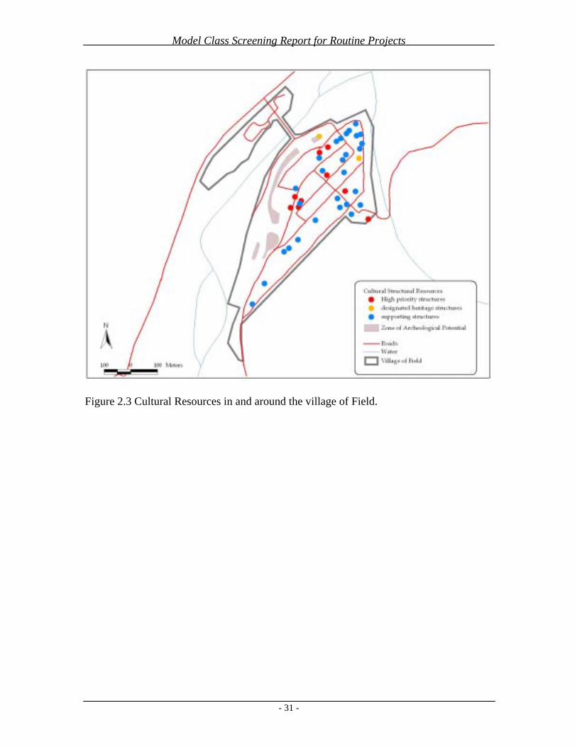
Model Class Screening Report for Routine Projects
- 31 -
Figure 2.3 Cultural Resources in and around the village of Field.

Model Class Screening Report for Routine Projects
- 32 -
Figure 2.4 Land use categories in the Village of Field.

Model Class Screening Report for Routine Projects
- 33 -
Figure 2.5 Contaminated sites in the Village of Field.

Model Class Screening Report for Routine Projects
- 34 -
3. Jasper, Jasper National Park of Canada
3.1. Spatial Boundaries of the Class Screening Area The Model Class Screening for Routine Projects in Jasper includes projects that occur within the community boundary as defined in the Jasper Community Land Use Plan. In addition, the following proximate outlying areas will be included in the class screening: Pine Bungalows, Tekarra Lodge, Alpine Village, Whistler’s Campground, Wapiti Campground, Jasper House Bungalows, Becker’s Roaring River Chalets, Patricia Lake Bungalows, Pyramid Riding Stables, Pyramid Lake Resort, Jasper Park Lodge, Jasper Cemetery, Lake Edith Resort Subdivision and Wastewater Treatment Plant.
The above areas will be considered part of the Class Screening Area (CSA). Only routine projects within the CSA are covered by the MCSR.
3.2. Environmental Description The town of Jasper is located in Jasper National Park of Canada with a permanent resident population of approximately 4700. The town’s elevation is approximately 1060m ASL and is situated within the confluence of the Athabasca, Miette, and Maligne Valleys (known as the three valley confluence – 3VC). Jasper National Park provides visitor services to nearly two million people each year and the town of Jasper accommodates up to 20 000 people on any given day throughout the summer. The regional environmental setting will be described followed by a more detailed description of the local setting. Table 3.1 and 3.2 summarize the environmental sensitivities of the ecosites and land use districts.
3.2.1. Regional Setting The Ecological Land Classification (Holland et al 1982) details landform and soil, vegetation and wildlife information, with increasing levels of detail progressing from ecoregion, to ecosection to ecosite. Ecoregions are based primarily on vegetation, which reflects microclimate, and are divided into ecosections that are based on broad landform, drainage and soil characteristics. Ecosections are further divided into ecosites, which are base on specific soil and vegetation differences. Ecosites found in the CSA are shown in Figure 3.2.
The Montane Ecoregion is found at lower elevations in Jasper and is characterized by vegetation types dominated by: ¶ Douglas fir, lodgepole pine, white spruce ¶ Aspen, and¶ Grasslands on drier sites.
The Montane Ecoregion occurs in the valley bottom from the east boundary along the Athabasca Valley to the west boundary along the Miette Valley, approximately 78 km. Highway 16 and the CN Rail are the main traffic routes that run through this area of montane. The montane ecoregion extends further south along the Athabasca Valley for

Model Class Screening Report for Routine Projects
- 35 -
approximately 45 km. Highway 93 is the main travel route through this area of montane. Douglas fir and lodgepole pine forests, inter mixed with aspen, dominate the area around the Jasper townsite. The Athabasca River lies to the east of the town and flows northeast through the Athabasca Valley.
The Subalpine Ecoregion, which occurs at elevations above the Montane, is cooler and moister, and is divided into Lower and Upper Subalpine. The dominant vegetation in the Lower Subalpine is closed coniferous forest, with mature forests dominated by Englemann spruce and Subalpine fir. The Upper Subalpine vegetation is transitional between Lower Subalpine closed forest and the treeless Alpine tundra, with open forests and stunted tree growth.
3.2.2. Air Quality Changes in air quality within the town have not been monitored. Train locomotives in the CN yard, traffic on the Yellowhead Highway (Hwy 16), ATCO power plant exhaust, and campfire smoke from Whistler and Wapiti Campgrounds have contributed to deterioration in air quality. While occasionally some people may be affected in a few locations, current levels of air pollution do not appear to pose a threat to ecological integrity.
3.2.3. Hydrology, Water Quality and Aquatic Resources The Athabasca River, a Canadian Heritage River, lies to the east of the town and flows northeast through the Athabasca Valley. Two creeks flow through the town of Jasper: Cabin Creek and Cottonwood Creek. Cabin Creek originates at Cabin Lake above the town and flows through the west end of the town to the Miette River. Cottonwood Creek’s headwaters are above the town on Pyramid Bench. The creek flows east through the town to the Athabasca River.
The new Jasper Wastewater Treatment Plant discharges treated effluent into the Athabasca River. The effluent quality from the new plant is highly improved from the inadequate lagoon system previously used. Storm water indirectly flows from the east end of the town into Cottonwood Creek. This causes sediment loading of the creek during spring run-off and heavy rainfalls in the summer.
Native fish species within the Athabasca River include Bull Trout, Rainbow Trout, Mountain Whitefish, Lake Whitefish, Northern Pike, Burbot, Longnose Sucker, Spoonhead Sculpin, and Lake Chub. Non-native species are Eastern Brook Trout and Rainbow Trout. The Rainbow Trout in the Athabasca River may be the result of inter-breeding between native and planted stock.
3.2.4. Landforms and Soils The Jasper townsite is located entirely with in the AT1 ecosite. Landforms in AT1 ecosite occur on terraces of glaciofluvial material (B material). Soils are well-drained orthic and eluviated eutric brunisols.

Model Class Screening Report for Routine Projects
- 36 -
3.2.5 Vegetation Forests are predominately coniferous inter-mixed with aspen stands. Douglas fir, lodgepole pine and aspen are dominant tree species around Jasper townsite. White spruce and balsam poplar are found in more hydric sites. The majority of the land within the townsite is developed, however the area between Hwy 16 and the CN tracks, known as Sleepy Hollow is undisturbed.
The ecosites in the CSA and their environmental characteristics are described in Table 3.2 and shown in Figure 3.2. Figure 3.3 indicates the locations of parks and parkettes.
Athabasca Ecosite 1 (AT1) and 3 (AT3)
The AT1 ecosite occurs on terraces of glaciofluvial material with slopes between 1% to 15%. Lodgepole pine forests dominate the vegetation types. The Jasper townsite lies entirely within the AT1 ecosite. This is largely a residential and commercial area, the majority of which has been developed.
AT3 is found on the Northwest side of Lake Edith Cottage area. The AT3 ecosite occurs on terraces of glaciofluvial material with slopes 0 to 5%. Grasslands with junegrass, pasture sage, and wild blue flax dominate with some mix of lodgepole pine, juniper, and bearberry forest type.
Patricia Ecosite 4 (PT4)
The PT4 ecosite is common to benchlands and have well drained soils with slopes from 5 to 30%. The dominant vegetation is aspen, hairy wild rye and peavine forests intermixed with lodgepole pine and buffaloberry. Some Douglas fir is present. PT4 is found on the Pyramid bench including Patricia Lake Resort, Pyramid Lake Resort, and Pyramid Riding Stables.
Hillsdale Ecosite 1 (HD1) and 4 (HD4)
HD1 is found in the Whistler’s Campground and Becker’s Chalet area. Landforms are linear slopes on fluvial fans or aprons, with slopes from 1 to 15%. Aspen forests are typical with portions of balsam poplar and buffaloberry.
HD4 is located at the north end of the Lake Edith Cottage area and consists of fluvial material within fan and apron landforms, with slopes of 1 to 15%. Dry grassland is the main vegetation type with a lesser amount of lodgepole pine, juniper and bearberry mix.
Fireside Ecosite 1 (1)
The FR1 ecosite consists of fluvial material on fans or aprons with slopes from 2 to 30%. Lodgepole pine forests with a buffaloberry, showy aster and twinflower understory is dominant. FR1 is found at the Northeast end of the Lake Edith Cottage area and around the Maligne Horse Range.

Model Class Screening Report for Routine Projects
- 37 -
Public Service and Institutional Districts, including Railway Lands and the Jasper Train Station, are scattered throughout the Town, as are areas of Parkland.
Environmental Protection Districts are located on the periphery of the Town, are largely undeveloped and provide buffers between the developed area of the Town and the undeveloped area of Jasper National Park.
Outlying Commercial Accommodations (OCA) include Pine Bungalows, Tekarra Lodge, Alpine Village, Whistler’s Campground, Wapiti Campground, Jasper House Bungalows, Becker’s Roaring River Chalets, Patricia Lake Bungalows, Pyramid Lake Resort, Jasper Cemetery and Jasper Park Lodge. They are all located in close proximity to the Town (Figure 3.1).
3.2.6 Wildlife Habitat and Populations The Montane Ecoregion is important habitat for ungulates and carnivores, providing grazing/browsing and hunting opportunities. The 3VC is a vital wildlife movement corridor and has several pinch points, which funnel wildlife movement in and through the area (Figure 3.6). Facilitating movement within the 3VC is very important to large carnivores and ungulates.
Large carnivores such as wolves, black bears and grizzlies use the 3VC to hunt, forage and travel between areas. Wolves hunt the resident elk population near the vicinity of the town during the winter. The Montane Ecoregion is also productive for small carnivores, small mammals and has medium importance for breeding birds.
3.2.7 Heritage Resources The primary heritage resources in the Jasper CSA are historical buildings and archaeological sites. Archaeological sites in the Town of Jasper and in the OCA area are found in Figures 3.3 and 3.4.
A Built Heritage Resource Description and Analysis (BHRDA) report for Jasper was prepared by Parks Canada in 1992. The BHRDA uses the following criteria to identify and evaluate buildings:
¶ Historical associations – thematic, person/event and local development ¶ Architecture – design, craftsmanship/materials and builder/architect ¶ Environment – historical integrity, setting and landmark
Jasper has 135 BHRDA listed heritage buildings, of which, 30 are A listed, 49 are Blisted, and 56 are C listed. A listed buildings have a major significance and importance; Blisted buildings are illustrative of building phases within the town; and C listed buildings are of value to the townsite environment.
One of the strategic goals of the Jasper Park Management Plan (2000) is to ensure the commemorative integrity of national historic sites. Within the town the Jasper Information Centre is a national historic site. In addition, the Jasper Community Land
Model Class Screening Report for Routine Projects
- 38 -
Use Plan (2001) identifies eight key actions for protecting Jasper’s cultural resources.
3.2.8 Socio-economics Increasing pressures from inside or outside the Jasper community include: ¶ Controlled residential and commercial growth in the town, ¶ Increasing number of park visitors, ¶ The Canadian National Railway and Yellowhead Highway pass through the park ¶ Logging, oil and gas exploration and coal mining fragment the regional habitat.
Jasper has a year round resident population of 4,700. Visitors to Jasper National Park have increased approximately three percent annually since the early 1970’s, with an estimated 1.4 million visiting or passing through the park each year. Vehicle traffic on the Yellowhead Highway has increased about three percent annually. Trains using the CNR number approximately 30-35 each day. Future increases in residency and tourism facilities will increase the pressure on water supply, electrical and natural gas supply, and road infrastructure.
Under CEAA, only those socio-economic effects that result directly from environmental effects need to be addressed in environmental assessment. To date this is not the case, therefore socio-economic issues are not specifically addressed further in the MCSR.
3.2.9 Aesthetics Negative visual and/or auditory impacts in Jasper are caused by the CNR, Yellowhead Highway traffic, increasing number of visitors, traffic congestion within the town during peak summer periods and reduced air quality (trains, vehicles, and campfires). These impacts may affect mountain viewscapes and the wilderness experience that visitors and residents expect to find in Jasper.

Model Class Screening Report for Routine Projects
- 39 -
Tabl
e 3.
1 Su
mm
ary
of L
and
Use
Dis
trict
s and
Env
ironm
enta
l Des
crip
tions
.
Eco
site
’s Im
port
ance
to
Wild
life(b
)
Lan
d U
se
Dis
tric
t
Con
stru
ctio
n of
Pe
rmitt
ed
Bui
ldin
gsE
nvir
onm
enta
l D
escr
iptio
n (e
cosi
te a
nd
deve
lopm
ent s
tatu
s)(b
)
Veg
etat
ion
Cov
er(b
)L
andf
orm
—
(slo
pes,
soils
)(b)
Ungulates(a)
Carnivores(a)
SmallMammals
(a)
Breeding Birds
(a)
Sens
itivi
ties(f
)
Com
mer
cial
(C)
Com
mer
cial
D
istri
ct C
1 Pe
rmitt
ed U
ses:
- a
partm
ent h
ousi
ng
- ret
ail s
tore
s - p
rofe
ssio
nal,
finan
cial
, and
off
ice
supp
ort
max
. FA
R(c
) = 2
.25
max
. Site
Cov
= 9
0%
max
. hei
ght =
9 m
Ath
abas
ca E
cosi
te 1
A
T1
3
Fully
Dev
elop
ed
Lodg
epol
e pi
ne,
juni
per,
bear
berr
y.
slop
e =
com
plex
, 0-5
%
AT1
land
form
= te
rrac
e so
il ty
pe =
eut
ric b
runi
sol
PM(d
) text
ure
= gl
acio
fluvi
al
coar
se
A
AA
A
Tour
ist
Com
mer
cial
D
istri
ct C
2
Perm
itted
Use
s:
- hot
els
- mot
els
max
. FA
R =
1 m
ax. S
iteC
ov =
40%
m
ax. h
eigh
t = 9
m
Ath
abas
ca E
cosi
te 1
A
T1
3
Pa
rtly
Dev
elop
ed;
in
clud
es n
atur
al fo
rest
; bo
rder
ed b
y hi
gh d
ensi
ty
hous
ing
to th
e N
, S, a
nd W
.
Lodg
epol
e pi
ne,
juni
per,
bear
berr
y.
slop
e =
com
plex
, 0-5
%
AT1
land
form
= te
rrac
e so
il ty
pe =
eut
ric b
runi
sol
PM te
xtur
e =
glac
ifluv
ial
coar
se
M-
H(e
)V
H-
H(f
)H
H
th
e ec
osite
is ra
ted
as h
ighl
y im
porta
nt
to w
ildlif
e, a
nd
may
incl
ude
wet
ar
eas i
mpo
rtant
for
rept
iles a
nd
amph
ibia
ns;

Model Class Screening Report for Routine Projects
- 40 -
Eco
site
’s Im
port
ance
to
Wild
life(b
)
Lan
d U
se
Dis
tric
t
Con
stru
ctio
n of
Pe
rmitt
ed
Bui
ldin
gsE
nvir
onm
enta
l D
escr
iptio
n (e
cosi
te a
nd
deve
lopm
ent s
tatu
s)(b
)
Veg
etat
ion
Cov
er(b
)L
andf
orm
—
(slo
pes,
soils
)(b)
Ungulates(a)
Carnivores(a)
SmallMammals
(a)
Breeding Birds
(a)
Sens
itivi
ties(f
)
Tour
ist
Com
mer
cial
To
wn
Cen
treD
istri
ct C
3
Perm
itted
Use
s:
- hot
els
- mot
els
max
. FA
R =
1 m
ax. S
iteC
ov =
40%
m
ax. h
eigh
t = 9
m
Ath
abas
ca E
cosi
te 1
A
T1
3
Pa
rtly
Dev
elop
ed;
in
clud
es n
atur
al fo
rest
; bo
rder
ed b
y hi
gh d
ensi
ty
hous
ing
to th
e N
, S, a
nd W
.
Lodg
epol
e pi
ne,
juni
per,
bear
berr
y.
slop
e =
com
plex
, 0-5
%
AT1
land
form
= te
rrac
e so
il ty
pe =
eut
ric b
runi
sol
PM te
xtur
e =
glac
ifluv
ial
coar
se
M-
H(e
)V
H-
H(f
)H
H
th
e ec
osite
is ra
ted
as h
ighl
y im
porta
nt
to w
ildlif
e, a
nd
may
incl
ude
wet
ar
eas i
mpo
rtant
for
rept
iles a
nd
amph
ibia
ns;
Aut
omob
ile
Serv
ice
Stat
ion
Dis
trict
C4
Perm
itted
Use
s:
- aut
omob
ile se
rvic
e st
atio
ns
max
. FA
R =
1 m
ax. S
iteC
ov =
40%
m
ax. h
eigh
t = 9
m
Ath
abas
ca E
cosi
te 1
A
T1
3
Pa
rtly
Dev
elop
ed;
in
clud
es n
atur
al fo
rest
; bo
rder
ed b
y hi
gh d
ensi
ty
hous
ing
to th
e N
, S, a
nd W
.
Lodg
epol
e pi
ne,
juni
per,
bear
berr
y.
slop
e =
com
plex
, 0-5
%
AT1
land
form
= te
rrac
e so
il ty
pe =
eut
ric b
runi
sol
PM te
xtur
e =
glac
ifluv
ial
coar
se
M-
H(e
)V
H-
H(f
)H
H
th
e ec
osite
is ra
ted
as h
ighl
y im
porta
nt
to w
ildlif
e, a
nd
may
incl
ude
wet
ar
eas i
mpo
rtant
for
rept
iles a
nd
amph
ibia
ns;
Hos
tel
Dis
trict
C5
Perm
itted
Use
s:
- hos
tel
- sta
ff a
ccom
mod
atio
n
max
. FA
R =
1 m
ax. S
iteC
ov =
40%
m
ax. h
eigh
t = 9
m
Ath
abas
ca E
cosi
te 1
A
T1
3
Pa
rtly
Dev
elop
ed;
in
clud
es n
atur
al fo
rest
; bo
rder
ed b
y hi
gh d
ensi
ty
hous
ing
to th
e N
, S, a
nd W
.
Lodg
epol
e pi
ne,
juni
per,
bear
berr
y.
slop
e =
com
plex
, 0-5
%
AT1
land
form
= te
rrac
e so
il ty
pe =
eut
ric b
runi
sol
PM te
xtur
e =
glac
ifluv
ial
coar
se
M-
H(e
)V
H-
H(f
)H
H
th
e ec
osite
is ra
ted
as h
ighl
y im
porta
nt
to w
ildlif
e, a
nd
may
incl
ude
wet
ar
eas i
mpo
rtant
for
rept
iles a
nd
amph
ibia
ns;

Model Class Screening Report for Routine Projects
- 41 -
Eco
site
’s Im
port
ance
to
Wild
life(b
)
Lan
d U
se
Dis
tric
t
Con
stru
ctio
n of
Pe
rmitt
ed
Bui
ldin
gsE
nvir
onm
enta
l D
escr
iptio
n (e
cosi
te a
nd
deve
lopm
ent s
tatu
s)(b
)
Veg
etat
ion
Cov
er(b
)L
andf
orm
—
(slo
pes,
soils
)(b)
Ungulates(a)
Carnivores(a)
SmallMammals
(a)
Breeding Birds
(a)
Sens
itivi
ties(f
)
Stor
age
and
Serv
ices
D
istri
ct(B
lock
S)
Perm
itted
Use
s:
- util
ity se
rvic
es
- vet
erin
ary
serv
ices
- w
areh
ouse
s
Ath
abas
ca E
cosi
te 1
A
T1
3 La
rgel
y de
velo
ped;
Su
rrou
nded
by
natu
ral l
ands
bo
rder
ing
the
Tow
n bo
unda
ry,
incl
udin
g a
wild
life
corr
idor
to
the
north
, and
Par
klan
d. A
lso
bord
ers s
mal
l Env
ironm
enta
l Pr
otec
tion
bloc
k.
Lodg
epol
e pi
ne,
juni
per,
bear
berr
y
slop
e =
com
plex
, 0-5
%
AT1
land
form
= te
rrac
e so
il ty
pe =
eut
ric b
runi
sol
PM te
xtur
e =
galc
ioflu
vial
co
arse
AA
AA
Publ
ic O
pen
Spac
e O
Pe
rmitt
ed U
ses:
- p
ublic
par
ks
- out
door
recr
eatio
nal
- pla
ygro
unds
Ath
abas
ca E
cosi
te 1
A
T1
3
Fully
Dev
elop
ed; c
omm
erci
al
core
, sur
roun
ded
by o
ther
co
mm
erci
al a
nd p
ublic
serv
ice
dist
ricts
Lodg
epol
e pi
ne,
juni
per,
bear
berr
y
slop
e =
com
plex
, 0-5
%
AT1
land
form
= te
rrac
e so
il ty
pe =
eut
ric b
runi
sol
PM te
xtur
e =
glac
ioflu
vial
co
arse
AA
AA
high
wat
er ta
ble
Res
iden
tial
One
–Uni
tD
wel
ling
Dis
trict
R1
Perm
itted
Use
s:
- one
-uni
t dw
ellin
gs
- gar
ages
whe
n an
cilla
ry
to a
one
-uni
t dw
ellin
g - o
ne a
cces
sory
bui
ldin
g 4.
5m2
or le
ss
max
. Site
Cov
= 3
0%
max
. hei
ght =
9 m
Ath
abas
ca E
cosi
te 1
A
T1
3 La
rgel
y D
evel
oped
;
Surr
ound
ed m
ainl
y by
Pa
rkla
nd a
nd n
atur
al la
nds
bord
erin
g th
e To
wn
boun
dary
.
Lodg
epol
e pi
ne,
juni
per,
bear
berr
y
slop
e =
com
plex
, 0-5
%
AT1
land
form
= te
rrac
e so
il ty
pe =
eut
ric b
runi
sol
PM te
xtur
e =
galc
ioflu
vial
co
arse
AA
AA
adja
cenc
y to
en
viro
nmen
tal
prot
ectio
n la
nds a
nd
fore
sted
land
s with
an
eco
site
rank
ing
as
high
ly im
porta
nt to
w
ildlif
e.
eros
ion
and
vege
tatio
n re
clam
atio
n co
ncer
ns
on so
uthe
rly a
spec
ts.
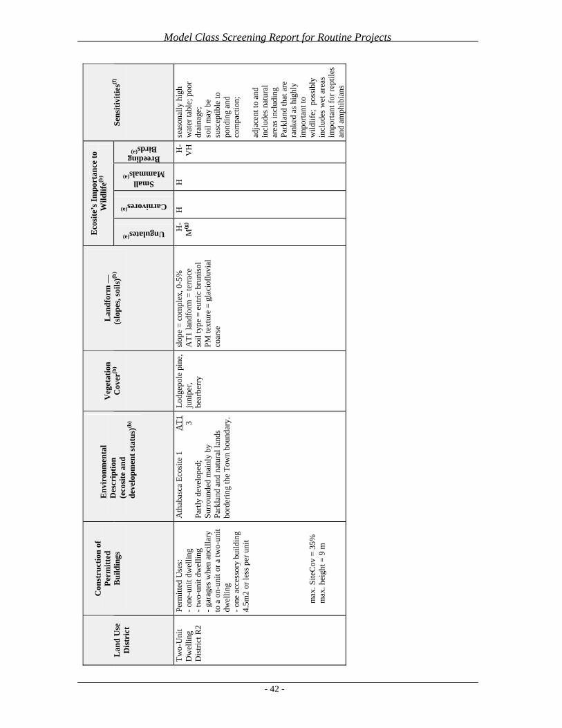
Model Class Screening Report for Routine Projects
- 42 -
Eco
site
’s Im
port
ance
to
Wild
life(b
)
Lan
d U
se
Dis
tric
t
Con
stru
ctio
n of
Pe
rmitt
ed
Bui
ldin
gsE
nvir
onm
enta
l D
escr
iptio
n (e
cosi
te a
nd
deve
lopm
ent s
tatu
s)(b
)
Veg
etat
ion
Cov
er(b
)L
andf
orm
—
(slo
pes,
soils
)(b)
Ungulates(a)
Carnivores(a)
SmallMammals
(a)
Breeding Birds
(a)
Sens
itivi
ties(f
)
Two-
Uni
tD
wel
ling
Dis
trict
R2
Perm
itted
Use
s:
- one
-uni
t dw
ellin
g - t
wo-
unit
dwel
ling
- gar
ages
whe
n an
cilla
ry
to a
on-
unit
or a
two-
unit
dwel
ling
- one
acc
esso
ry b
uild
ing
4.5m
2 or
less
per
uni
t
max
. Site
Cov
= 3
5%
max
. hei
ght =
9 m
Ath
abas
ca E
cosi
te 1
A
T1
3 Pa
rtly
deve
lope
d;
Surr
ound
ed m
ainl
y by
Pa
rkla
nd a
nd n
atur
al la
nds
bord
erin
g th
e To
wn
boun
dary
.
Lodg
epol
e pi
ne,
juni
per,
bear
berr
y
slop
e =
com
plex
, 0-5
%
AT1
land
form
= te
rrac
e so
il ty
pe =
eut
ric b
runi
sol
PM te
xtur
e =
glac
ioflu
vial
co
arse
H-
M(g
) H
HH
-V
Hse
ason
ally
hig
h w
ater
tabl
e; p
oor
drai
nage
; so
il m
ay b
e su
scep
tible
to
pond
ing
and
com
pact
ion;
adja
cent
to a
nd
incl
udes
nat
ural
ar
eas i
nclu
ding
Pa
rkla
nd th
at a
re
rank
ed a
s hig
hly
impo
rtant
to
wild
life;
pos
sibl
y in
clud
es w
et a
reas
im
porta
nt fo
r rep
tiles
an
d am
phib
ians

Model Class Screening Report for Routine Projects
- 43 -
Eco
site
’s Im
port
ance
to
Wild
life(b
)
Lan
d U
se
Dis
tric
t
Con
stru
ctio
n of
Pe
rmitt
ed
Bui
ldin
gsE
nvir
onm
enta
l D
escr
iptio
n (e
cosi
te a
nd
deve
lopm
ent s
tatu
s)(b
)
Veg
etat
ion
Cov
er(b
)L
andf
orm
—
(slo
pes,
soils
)(b)
Ungulates(a)
Carnivores(a)
SmallMammals
(a)
Breeding Birds
(a)
Sens
itivi
ties(f
)
Old
Tow
n Ja
sper
H
isto
ricD
istri
ct R
2H
Perm
itted
Use
s:
- one
-uni
t dw
ellin
g - t
wo-
unit
dwel
ling
- gar
ages
whe
n an
cilla
ry
to a
on-
unit
or a
two-
unit
dwel
ling
- one
acc
esso
ry b
uild
ing
4.5m
2 or
less
per
uni
t
max
. Site
Cov
= 3
5%
max
. hei
ght =
9 m
Ath
abas
ca E
cosi
te 1
A
T1
3 Pa
rtly
deve
lope
d;
Surr
ound
ed m
ainl
y by
Pa
rkla
nd a
nd n
atur
al la
nds
bord
erin
g th
e To
wn
boun
dary
.
Lodg
epol
e pi
ne,
juni
per,
bear
berr
y
slop
e =
com
plex
, 0-5
%
AT1
land
form
= te
rrac
e so
il ty
pe =
eut
ric b
runi
sol
PM te
xtur
e =
glac
ioflu
vial
co
arse
H-
M(g
) H
HH
-V
Hse
ason
ally
hig
h w
ater
tabl
e; p
oor
drai
nage
; so
il m
ay b
e su
scep
tible
to
pond
ing
and
com
pact
ion;
adja
cent
to a
nd
incl
udes
nat
ural
ar
eas i
nclu
ding
Pa
rkla
nd th
at a
re
rank
ed a
s hig
hly
impo
rtant
to
wild
life;
pos
sibl
y in
clud
es w
et a
reas
im
porta
nt fo
r rep
tiles
an
d am
phib
ians

Model Class Screening Report for Routine Projects
- 44 -
Eco
site
’s Im
port
ance
to
Wild
life(b
)
Lan
d U
se
Dis
tric
t
Con
stru
ctio
n of
Pe
rmitt
ed
Bui
ldin
gsE
nvir
onm
enta
l D
escr
iptio
n (e
cosi
te a
nd
deve
lopm
ent s
tatu
s)(b
)
Veg
etat
ion
Cov
er(b
)L
andf
orm
—
(slo
pes,
soils
)(b)
Ungulates(a)
Carnivores(a)
SmallMammals
(a)
Breeding Birds
(a)
Sens
itivi
ties(f
)
Mul
ti –U
nit
Smal
l Lot
D
wel
ling
Dis
trict
R3a
Perm
itted
Use
s:
- one
-uni
t dw
ellin
gs
- tw
o-un
it dw
ellin
gs
- mul
ti-un
it dw
ellin
gs
- one
acc
esso
ry b
uild
ing
cont
aini
ng 4
.5m
2 or
less
pe
r res
iden
tial u
nit
- gar
ages
whe
n an
cilla
ry
to a
resi
dent
ial
deve
lopm
ent
max
. Site
Cov
= 4
0%
max
. hei
ght =
13.
7 m
Ath
abas
ca E
cosi
te 1
A
T1
3 La
rgel
y de
velo
ped;
Su
rrou
nded
by
natu
ral l
ands
bo
rder
ing
the
Tow
n bo
unda
ry,
incl
udin
g a
wild
life
corr
idor
to
the
north
, and
Par
klan
d. A
lso
bord
ers s
mal
l Env
ironm
enta
l Pr
otec
tion
bloc
k.
Lodg
epol
e pi
ne,
juni
per,
bear
berr
y
slop
e =
com
plex
, 0-5
%
AT1
land
form
= te
rrac
e so
il ty
pe =
eut
ric b
runi
sol
PM te
xtur
e =
glac
ioflu
vial
co
arse
AA
AA
incl
udes
smal
l are
as
of, a
nd is
adj
acen
t to
natu
ral a
reas
, in
clud
ing
Park
land
an
d En
viro
nmen
tal
Prot
ectio
n, th
at a
re
rank
ed a
s hig
hly
impo
rtant
to
wild
life;
als
o,
wild
life
corr
idor
. m
ay h
ave
high
wat
er
tabl
e.
Mul
ti –U
nit
Dw
ellin
gD
istri
ct R
3b
Perm
itted
Use
s:
- apa
rtmen
ts
- row
hou
ses
- gar
ages
whe
n an
cilla
ry
to a
dw
ellin
g de
velo
pmen
t- o
ne a
cces
sory
bui
ldin
g co
ntai
ning
4.5
m2
or le
ss
per r
esid
entia
l uni
t
max
. Site
Cov
= 4
0%
max
. hei
ght =
13.
7 m
Ath
abas
ca E
cosi
te 1
A
T1
3 La
rgel
y de
velo
ped;
Su
rrou
nded
by
natu
ral l
ands
bo
rder
ing
the
Tow
n bo
unda
ry,
incl
udin
g a
wild
life
corr
idor
to
the
north
, and
Par
klan
d. A
lso
bord
ers s
mal
l Env
ironm
enta
l Pr
otec
tion
bloc
k.
Lodg
epol
e pi
ne,
juni
per,
bear
berr
y
slop
e =
com
plex
, 0-5
%
AT1
land
form
= te
rrac
e so
il ty
pe =
eut
ric b
runi
sol
PM te
xtur
e =
glac
ioflu
vial
co
arse
AA
AA
incl
udes
smal
l are
as
of, a
nd is
adj
acen
t to
natu
ral a
reas
, in
clud
ing
Park
land
an
d En
viro
nmen
tal
Prot
ectio
n, th
at a
re
rank
ed a
s hig
hly
impo
rtant
to
wild
life;
als
o,
wild
life
corr
idor
. m
ay h
ave
high
wat
er
tabl
e.

Model Class Screening Report for Routine Projects
- 45 -
Eco
site
’s Im
port
ance
to
Wild
life(b
)
Lan
d U
se
Dis
tric
t
Con
stru
ctio
n of
Pe
rmitt
ed
Bui
ldin
gsE
nvir
onm
enta
l D
escr
iptio
n (e
cosi
te a
nd
deve
lopm
ent s
tatu
s)(b
)
Veg
etat
ion
Cov
er(b
)L
andf
orm
—
(slo
pes,
soils
)(b)
Ungulates(a)
Carnivores(a)
SmallMammals
(a)
Breeding Birds
(a)
Sens
itivi
ties(f
)
Com
pact
Lo
t Dis
trict
R
4
Perm
itted
Use
s:
- man
ufac
ture
d ho
mes
- c
arpo
rts
- acc
esso
ry b
uild
ings
Ath
abas
ca E
cosi
te 1
A
T1
3
Lo
dgep
ole
pine
, ju
nipe
r, be
arbe
rry
slop
e =
com
plex
, 0-5
%
AT1
land
form
= te
rrac
e so
il ty
pe =
eut
ric b
runi
sol
PM te
xtur
e =
galc
ioflu
vial
co
arse
HH
HH
-V
H
Cab
in C
reek
W
est O
ne-
Uni
tD
wel
ling
Dis
trict
CC
Wa
Perm
itted
Use
s:
- one
-uni
t dw
ellin
gs
- gar
ages
atta
ched
to th
e pr
imar
y bu
ildin
g -
acce
ssor
y bu
ildin
gs
Ath
abas
ca E
cosi
te 1
A
T1
3
Lo
dgep
ole
pine
, ju
nipe
r, be
arbe
rry
slop
e =
com
plex
, 0-5
%
AT1
land
form
= te
rrac
e so
il ty
pe =
eut
ric b
runi
sol
PM te
xtur
e =
galc
ioflu
vial
co
arse
HH
HH
-V
H

Model Class Screening Report for Routine Projects
- 46 -
Eco
site
’s Im
port
ance
to
Wild
life(b
)
Lan
d U
se
Dis
tric
t
Con
stru
ctio
n of
Pe
rmitt
ed
Bui
ldin
gsE
nvir
onm
enta
l D
escr
iptio
n (e
cosi
te a
nd
deve
lopm
ent s
tatu
s)(b
)
Veg
etat
ion
Cov
er(b
)L
andf
orm
—
(slo
pes,
soils
)(b)
Ungulates(a)
Carnivores(a)
SmallMammals
(a)
Breeding Birds
(a)
Sens
itivi
ties(f
)
Cab
in C
reek
W
est T
wo-
Uni
tD
wel
ling
Dis
trict
CC
Wb
Perm
itted
Use
s:
- tw
o-un
it dw
ellin
gs
- gar
ages
atta
ched
to th
e pr
imar
y bu
ildin
g -
acce
ssor
y bu
ildin
gs
Ath
abas
ca E
cosi
te 1
A
T1
3
Lo
dgep
ole
pine
, ju
nipe
r, be
arbe
rry
slop
e =
com
plex
, 0-5
%
AT1
land
form
= te
rrac
e so
il ty
pe =
eut
ric b
runi
sol
PM te
xtur
e =
galc
ioflu
vial
co
arse
HH
HH
-V
H
Cab
in C
reek
W
est M
ulti-
Uni
tD
wel
ling
Dis
trict
CC
Wc
Perm
itted
Use
s:
- row
-hou
ses
- gar
ages
atta
ched
to th
e pr
imar
y bu
ildin
g -
acce
ssor
y bu
ildin
gs
Ath
abas
ca E
cosi
te 1
A
T1
3
Lo
dgep
ole
pine
, ju
nipe
r, be
arbe
rry
slop
e =
com
plex
, 0-5
%
AT1
land
form
= te
rrac
e so
il ty
pe =
eut
ric b
runi
sol
PM te
xtur
e =
galc
ioflu
vial
co
arse
HH
HH
-V
H
Inst
itutio
nal
Dis
trict
I Pe
rmitt
ed U
ses:
- n
one
Dis
cret
iona
l Use
s:
- ins
titut
iona
l, go
vern
men
tal,
educ
atio
nal,
or
com
mun
ity se
rvic
e na
ture
Ath
abas
ca E
cosi
te 1
A
T1
3
Lo
dgep
ole
pine
, ju
nipe
r, be
arbe
rry
slop
e =
com
plex
, 0-5
%
AT1
land
form
= te
rrac
e so
il ty
pe =
eut
ric b
runi
sol
PM te
xtur
e =
glac
ioflu
vial
co
arse
HH
HH
-V
H

Model Class Screening Report for Routine Projects
- 47 -
Eco
site
’s Im
port
ance
to
Wild
life(b
)
Lan
d U
se
Dis
tric
t
Con
stru
ctio
n of
Pe
rmitt
ed
Bui
ldin
gsE
nvir
onm
enta
l D
escr
iptio
n (e
cosi
te a
nd
deve
lopm
ent s
tatu
s)(b
)
Veg
etat
ion
Cov
er(b
)L
andf
orm
—
(slo
pes,
soils
)(b)
Ungulates(a)
Carnivores(a)
SmallMammals
(a)
Breeding Birds
(a)
Sens
itivi
ties(f
)
Publ
icSe
rvic
es
Dis
trict
PS
Perm
itted
Use
s:
- gov
ernm
ent s
ervi
ces
- tra
nspo
rtatio
n se
rvic
es
- pub
lic p
arki
ng a
reas
Ath
abas
ca E
cosi
te 1
A
T1
3
Lo
dgep
ole
pine
, ju
nipe
r, be
arbe
rry
slop
e =
com
plex
, 0-5
%
AT1
land
form
= te
rrac
e so
il ty
pe =
eut
ric b
runi
sol
PM te
xtur
e =
glac
ioflu
vial
co
arse
HH
HH
-V
H
Rai
lyar
d D
istri
ct R
Y
Perm
itted
Use
s:
- rai
lway
serv
ices
A
thab
asca
Eco
site
1
AT1
3
Lodg
epol
e pi
ne,
juni
per,
bear
berr
y
slop
e =
com
plex
, 0-5
%
AT1
land
form
= te
rrac
e so
il ty
pe =
eut
ric b
runi
sol
PM te
xtur
e =
glac
ioflu
vial
co
arse
HH
HH
-V
H
Res
iden
tial
Res
erve
RR
Pe
rmitt
ed U
ses:
- r
eser
ve la
nd fo
r fut
ure
resi
dent
ial d
evel
opm
ent
Ath
abas
ca E
cosi
te 1
A
T1
3
Lo
dgep
ole
pine
, ju
nipe
r, be
arbe
rry
slop
e =
com
plex
, 0-5
%
AT1
land
form
= te
rrac
e so
il ty
pe =
eut
ric b
runi
sol
PM te
xtur
e =
glac
ioflu
vial
co
arse
HH
HH
-V
H
Com
mun
ity
Res
erve
CR
Pe
rmitt
ed U
ses:
- r
eser
ve la
nd fo
r fut
ure
non-
com
mer
cial
deve
lopm
ent i
nclu
ding
ho
usin
g
Ath
abas
ca E
cosi
te 1
A
T1
3
Lo
dgep
ole
pine
, ju
nipe
r, be
arbe
rry
slop
e =
com
plex
, 0-5
%
AT1
land
form
= te
rrac
e so
il ty
pe =
eut
ric b
runi
sol
PM te
xtur
e =
glac
ioflu
vial
co
arse
HH
HH
-V
H
(a)
A: A
ltere
d:Ec
osite
is la
rgel
y or
fully
dev
elop
ed a
nd a
ll or
muc
h of
the
natu
ral h
abita
t has
bee
n re
mov
ed.
Wild
life
may
use
the
rem
aini
ng o
r int
rodu
ced
vege
tatio
n.
H: H
igh
VH
: Ver
y H
igh
M: M
oder
ate

Model Class Screening Report for Routine Projects
- 48 -
(b)
Sour
ce:
Hol
land
and
Coe
n, 1
983.
Eco
logi
cal (
Bio
phys
ical
) Lan
d C
lass
ifica
tion
of B
anff
and
Jasp
er N
atio
nal P
arks
. V
ol II
: Soi
l and
Veg
etat
ion
Res
ourc
es.
H
olro
yd a
nd V
an T
ighe
n. 1
983.
Eco
logi
cal (
Bio
phys
ical
) Lan
d C
lass
ifica
tion
of B
anff
and
Jasp
er N
atio
nal P
arks
. V
ol. I
II: W
ildlif
e In
vent
ory.
(c
) FA
R =
max
imum
floo
r are
a ra
tio
Site
Cov
= m
axim
um si
te c
over
age.
(d
) PM
= p
aren
t mat
eria
l(e
)
mod
erat
e in
sum
mer
, hig
h in
win
ter
(f)
very
hig
h in
sum
mer
, hig
h in
win
ter
(g) h
igh
in w
inte
r, m
ediu
m in
sum
mer

Model Class Screening Report for Routine Projects
- 49 -
Tabl
e 3.
2 Su
mm
ary
of O
utly
ing
Are
as a
nd E
nviro
nmen
tal D
escr
iptio
ns.
Eco
site
’s Im
port
ance
to W
ildlif
e(a,b
)
Are
as in
V
icin
ity
of th
e T
own
Env
iron
men
tal
Des
crip
tion
(eco
site
and
de
velo
pmen
t sta
tus)
(b)
Veg
etat
ion
Cov
er(b
)L
andf
orm
—
(slo
pes,
soils
)(b)
Ungulates(a)
Carnivores(a)
SmallMammals
(a)
Breeding Birds
(a)
Sens
itivi
ties(f
)
Out
side
Tow
n of
Jas
per:
Hig
hway
93
& 9
3aTe
karr
a Lo
dge
Ath
abas
ca E
cosi
te 1
A
T1
3 Lo
dgep
ole
pine
, ju
nipe
r, be
arbe
rry
slop
e =
0-5
%
AT1
land
form
= te
rrac
e so
il ty
pe =
eut
ric b
runi
sol
PM(c
) text
ure
= ga
lcio
fluvi
al c
oars
e
H(a
) H
H
/M(d
)M
Eo
site
is ra
nked
hig
hly
impo
rtant
to u
ngul
ates
an
d pr
edat
ors b
ecau
se o
f its
war
m te
mpe
ratu
res
and
low
snow
acc
umul
atio
ns.
Clo
se p
roxi
mity
to th
e A
thab
asca
Riv
er.
Wild
life
corr
idor
. A
lpin
eV
illag
eA
thab
asca
Eco
site
1
A
T1
3
Lodg
epol
e pi
ne,
juni
per,
bear
berr
y sl
ope
= 0
-5%
A
T1 la
ndfo
rm =
terr
ace
soil
type
= e
utric
bru
niso
l PM
text
ure
= ga
lcio
fluvi
al c
oars
e
H
H
H/M
(d)
M
Eosi
te is
rank
ed h
ighl
y im
porta
nt to
ung
ulat
es
and
pred
ator
s bec
ause
of i
ts w
arm
tem
pera
ture
s an
d lo
w sn
ow a
ccum
ulat
ions
.
Clo
se p
roxi
mity
to th
e A
thab
asca
Riv
er .
Wild
life
corr
idor
. Ja
sper
Hou
se
Bun
galo
ws
Ath
abas
ca E
cosi
te 1
AT1
3 Lo
dgep
ole
pine
, ju
nipe
r, be
arbe
rry
sl
ope
= 0
-5%
A
T1 la
ndfo
rm =
terr
ace
soil
type
= e
utric
bru
niso
l PM
text
ure
= co
arse
gla
ciof
luvi
al
H
H
H/M
(d)
M
Eosi
te is
rank
ed h
ighl
y im
porta
nt to
ung
ulat
es
and
pred
ator
s bec
ause
of i
ts w
arm
tem
pera
ture
s an
d lo
w sn
ow a
ccum
ulat
ions
.
Wild
life
corr
idor
. W
apiti
Cam
pgro
und
Ath
abas
ca E
cosit
e 1
A
T1
3c
Lodg
epol
e pi
ne,
juni
per,
bear
berr
y
slop
e =
com
plex
, 0-5
%
AT1
land
form
= te
rrac
e so
il ty
pe =
eut
ric b
runi
sol
PM te
xtur
e =
coar
se g
laci
oflu
vial
H
H
H/M
(d)
M
Eosi
te is
rank
ed h
ighl
y im
porta
nt to
ung
ulat
es
and
pred
ator
s bec
ause
of i
ts w
arm
tem
pera
ture
s an
d lo
w sn
ow a
ccum
ulat
ions
.
Wild
life
corr
idor
.

Model Class Screening Report for Routine Projects
- 50 -
Eco
site
’s Im
port
ance
to W
ildlif
e(a,b
)
Are
as in
V
icin
ity
of th
e T
own
Env
iron
men
tal
Des
crip
tion
(eco
site
and
de
velo
pmen
t sta
tus)
(b)
Veg
etat
ion
Cov
er(b
)L
andf
orm
—
(slo
pes,
soils
)(b)
Ungulates(a)
Carnivores(a)
SmallMammals
(a)
Breeding Birds
(a)
Sens
itivi
ties(f
)
Whi
stle
r'sC
ampg
roun
d A
thab
asca
Eco
site 1
AT1
3
c
Hill
sdal
e Ec
osite
1
H
D1
5
Lodg
epol
e pi
ne,
juni
per,
bear
berr
y
Asp
en, h
airy
wild
ry
e, p
eavi
ne
slop
e =
com
plex
, 0-5
%
AT1
land
form
= te
rrac
e so
il ty
pe =
eut
ric b
runi
sol
PM te
xtur
e =
coar
se g
laci
oflu
vial
Slop
e =
5-15
%
HD
1 la
ndfo
rm =
line
ar sl
opes
on
fans
and
apr
ons
Soils
= o
rthic
and
cum
ulic
re
goso
ls
PM te
xtur
e =
coar
se st
ratif
ied
fluvi
al
H H
H H
H/M
(d)
H
M H
Eosi
te is
rank
ed h
ighl
y im
porta
nt to
ung
ulat
es
and
pred
ator
s bec
ause
of i
ts w
arm
tem
pera
ture
s an
d lo
w sn
ow a
ccum
ulat
ions
.
Wild
life
corr
idor
.
HD
1 ve
ry im
porta
nt a
rea
for b
reed
ing
bird
s.
Bec
ker's
Roa
ring
Riv
er
Cha
lets
Hill
sdal
e Ec
osite
1
H
D1
5
A
spen
, hai
ry w
ild
rye,
pea
vine
Sl
ope
= 5-
15%
H
D1
land
form
= li
near
slop
es o
n fa
ns/ a
pron
s So
ils =
orth
ic a
nd c
umul
ic
rego
sols
PM
text
ure
= co
arse
stra
tifie
d flu
vial
H
H
H
H
Eosi
te is
rank
ed h
ighl
y im
porta
nt to
ung
ulat
es
and
pred
ator
s bec
ause
of i
ts w
arm
tem
pera
ture
s an
d lo
w sn
ow a
ccum
ulat
ions
.
Wild
life
corr
idor
.
Ver
y im
porta
nt a
rea
for b
reed
ing
bird
s. Py
ram
id L
ake
Roa
dPa
trici
a La
ke
Bun
galo
ws
Patri
cia E
cosit
e 4
P
T4
5c
Asp
en, h
airy
wild
ry
e, p
eavi
ne
slop
e =
com
plex
5-1
5%
land
form
= ri
dged
mor
rain
e ov
er
bedr
ock
so
il ty
pe =
eut
ric b
runi
sol/l
uvis
ol
PM te
xtur
e =
med
ium
M
H
H
VH
Ec
osite
is ra
nked
as h
ighl
y im
porta
nt to
ca
rniv
ores
and
bre
edin
g bi
rds.
Wild
life
corr
idor
Pyra
mid
R
idin
gSt
able
s
Patri
cia E
cosit
e 4
PT4
5c
Asp
en, h
airy
wild
ry
e, p
eavi
ne
slop
e =
com
plex
5-1
5%
land
form
= ri
dged
mor
rain
e o
ver
bedr
ock
so
il ty
pe =
eut
ric b
runi
sol/l
uvis
ol
PM te
xtur
e =
med
ium
M
H
H
VH
Ec
osite
is ra
nked
as h
ighl
y im
porta
nt to
ca
rniv
ores
and
bre
edin
g bi
rds.
Wild
life
corr
idor
Pyra
mid
Lak
e R
esor
tPa
trici
a Eco
site 4
PT
4
5c
A
spen
, hai
ry w
ild
rye,
pea
vine
sl
ope
= co
mpl
ex 5
-15%
la
ndfo
rm =
ridg
ed m
orra
ine
ove
r be
droc
k
soil
type
= e
utric
bru
niso
l/luv
isol
PM
text
ure
= m
ediu
m
M
H
H
VH
Ec
osite
is ra
nked
as h
ighl
y im
porta
nt to
ca
rniv
ores
and
bre
edin
g bi
rds.
Wild
life
corr
idor

Model Class Screening Report for Routine Projects
- 51 -
Eco
site
’s Im
port
ance
to W
ildlif
e(a,b
)
Are
as in
V
icin
ity
of th
e T
own
Env
iron
men
tal
Des
crip
tion
(eco
site
and
de
velo
pmen
t sta
tus)
(b)
Veg
etat
ion
Cov
er(b
)L
andf
orm
—
(slo
pes,
soils
)(b)
Ungulates(a)
Carnivores(a)
SmallMammals
(a)
Breeding Birds
(a)
Sens
itivi
ties(f
)
Mal
igne
Lak
e R
oad
Jasp
er P
ark
Lodg
e
Ath
abas
ca E
cosit
e 1
AT1
3c
Lo
dgep
ole
pine
, ju
nipe
r, be
arbe
rry
sl
ope
= co
mpl
ex, 0
-5%
A
T1 la
ndfo
rm =
terr
ace
soil
type
= e
utric
bru
niso
l PM
text
ure
= co
arse
gla
ciof
luvi
al
H
H
H/M
(d)
M
Eosi
te is
rank
ed h
ighl
y im
porta
nt to
ung
ulat
es
and
pred
ator
s bec
ause
of i
ts w
arm
tem
pera
ture
s an
d lo
w sn
ow a
ccum
ulat
ions
.
Wild
life
corr
idor
. La
ke E
dith
C
otta
ges
Ath
abas
ca E
cosit
e 1
AT1
3c
Ath
abas
ca E
cosit
e 3
A
T3
3
Hill
sdal
e Ec
osite
4
HD
4
3
Fire
side
Eco
site
1
FR
1
3c
Lodg
epol
e pi
ne,
juni
per,
bear
berr
y
Dry
gra
ssla
nd,
lodg
epol
e pi
ne,
juni
per,
bear
berr
y
Dry
gra
ssla
nd,
lodg
epol
e pi
ne,
juni
per,
bear
berr
y
Lodg
epol
e pi
ne,
buff
alob
erry
, sho
wy
aste
r
slop
e =
com
plex
, 0-5
%
AT1
& A
T3 la
ndfo
rm =
terr
ace
soil
type
= e
utric
bru
niso
l PM
text
ure
= co
arse
gla
ciof
luvi
al
HD
4 la
ndfo
rm =
line
ar sl
opes
on
fans
/ apr
ons
Soils
= o
rthic
and
cum
ulic
re
goso
ls
PM te
xtur
e =
coar
se st
ratif
ied
fluvi
al
FR1
land
form
= fa
n an
d ap
rons
So
ils =
eut
ric b
runi
sols
PM
text
ure
= co
arse
stra
tifie
d flu
vial
H VH
VH H
H H H H
H/M
(d)
H H H
M H H H
Eosi
te is
rank
ed h
ighl
y im
porta
nt to
ung
ulat
es
and
pred
ator
s bec
ause
of i
ts w
arm
tem
pera
ture
s an
d lo
w sn
ow a
ccum
ulat
ions
.
Wild
life
corr
idor
.
Hig
hway
16
Pine
Bun
galo
ws
Ath
abas
ca E
cosit
e 1
A
T1
3c
Lodg
epol
e pi
ne,
juni
per,
bear
berr
y sl
ope
= co
mpl
ex, 0
-5%
A
T1 la
ndfo
rm =
terr
ace
soil
type
= e
utric
bru
niso
l PM
text
ure
= co
arse
gla
ciof
luvi
al
H
H
H/M
(d)
M
Eosi
te is
rank
ed h
ighl
y im
porta
nt to
ung
ulat
es
and
pred
ator
s bec
ause
of i
ts w
arm
tem
pera
ture
s an
d lo
w sn
ow a
ccum
ulat
ions
.
Wild
life
corr
idor
. W
aste
wat
er
Trea
tmen
t Pl
ant
Ath
abas
ca E
cosit
e 1
A
T1
3c
Lodg
epol
e pi
ne,
juni
per,
bear
berr
y sl
ope
= co
mpl
ex, 0
-5%
A
T1 la
ndfo
rm =
terr
ace
soil
type
= e
utric
bru
niso
l PM
text
ure
= co
arse
gla
ciof
luvi
al
H
H
H/M
(d)
M
Eosi
te is
rank
ed h
ighl
y im
porta
nt to
ung
ulat
es
and
pred
ator
s bec
ause
of i
ts w
arm
tem
pera
ture
s an
d lo
w sn
ow a
ccum
ulat
ions
.
Wild
life
corr
idor
.

Model Class Screening Report for Routine Projects
- 52 -
(a)
A: A
ltere
d:Ec
osite
is la
rgel
y or
fully
dev
elop
ed a
nd a
ll or
muc
h of
the
natu
ral h
abita
t has
bee
n re
mov
ed.
Wild
life
may
use
the
rem
aini
ng o
r int
rodu
ced
vege
tatio
n.
H: H
igh
VH
: Ver
y H
igh
M: M
oder
ate
(b)
Sour
ce:
Hol
land
and
Coe
n, 1
983.
Eco
logi
cal (
Bio
phys
ical
) Lan
d C
lass
ifica
tion
of B
anff
and
Jasp
er N
atio
nal P
arks
. V
ol II
: Soi
l and
Veg
etat
ion
Res
ourc
es.
H
olro
yd a
nd V
an T
ighe
n. 1
983.
Eco
logi
cal (
Bio
phys
ical
) Lan
d C
lass
ifica
tion
of B
anff
and
Jasp
er N
atio
nal P
arks
. V
ol. I
II: W
ildlif
e In
vent
ory.
(c
) PM
= p
aren
t mat
eria
l(d
) H
igh
for b
ats,
mod
erat
e fo
r oth
er sm
all m
amm
als

Model Class Screening Report for Routine Projects
- 53 -
3.3. Description of Current Infrastructure in Each Project Class
3.3.1. Subclass 1 – Buildings
In 2002, 16 building permits were issued (3 commercial, 2 institutional and 10 residential), but there has been a moratorium in place on new building in the Town of Jasper since 1998. The moratorium should be lifted in 2003 and building permits are expected to increase by 4 to 5 times for residential alone. Approximately 17,000 square feet of new commercial space will be issued each year until the entire allocation of 100,000 square feet is used. The procedures and activities used to construct new buildings and mitigate environmental impacts are standard, and experienced contractors are hired. Contractors used by the Town of Jasper must have a Town of Jasper Business Licence. The construction of any buildings with dimensions greater than those permitted for given Districts in the Regulations will not be covered under this Class Screening, and will require a separate Environmental Screening under the CEAA.
On average, 1-2 permits are issued for Heritage Buildings each year. Requests for renovations to Heritage Buildings are reviewed through the development process for approval. Modifications of existing buildings are conducted according to industry standards and by experienced contractors. Modifications of Heritage Buildings owned by Parks Canada (PC) buildings are conducted by PC carpenters, under the supervision of the Federal Heritage Building Review Office. Larger projects can be contracted. Procedures similar to those used for original building construction are used for Heritage Buildings. Modifications, which do not comply with the Regulations Respecting the Use of Land in the Town of Jasper, are not covered under this Class Screening, and will require a separate Environmental Screening under the CEAA.
No federally or provincially recognized Heritage Buildings have been decommissioned. Decommissioning and abandonment of buildings is conducted according to industry standards and by experienced contractors.
3.3.2. Subclass 2 – Service Lines In 2002 services associated with the Town of Jasper were geared to provide for approximately 24 800 overnight visitors, made up of 20 000 tourists in commercial accommodation and 4 800 permanent or seasonal residents in residential accommodation. Services have been designed to accommodate “peak” demand (i.e. 24 800 people) on any given day. The Wastewater Treatment Plant is designed to handle a ‘peak’ demand of 30 000 people.
Utility service lines covered in this sub-class include: ¶ Water and sanitary sewer services provided by the Municipality of Jasper Corporate
and Environmental Services. ¶ Natural gas services provided by ATCO Gas; ¶ Electric power provided by ATCO Power and ATCO Electric; and ¶ Communication services provided by Telus and Shaw Cable.
Both underground and aboveground services are included. Present utility services are provided for a resident population of 4 700 and 15 000 overnight visitors.

Model Class Screening Report for Routine Projects
- 54 -
3.3.2.1. Water Supply Water is provided to all Town of Jasper facilities, as well as to Pine Bungalows, Tekerra Lodge and Alpine Lodge, by the Municipality of Jasper Corporate and Environmental Services Department. The water quality needs to conform to the Standards and Guidelines for Municipal Water Supply in Alberta.
The Town’s system is made up of three water wells (located at the Athabasca River near Old Fort Point), pumps which provide pressure to move water to the treatment centre (total pumping capacity of 400 m3 per hour) and a reservoir on Pyramid Bench. Ductile iron pipes carry the water to the reservoir and two main lines (a 300 mm and a 350 mm) from the reservoir to town.Older distribution pipes are largely ductile iron with lead joints, a significant portion having gasketted joints (rubber seal); newer pipes are polyvinyl chloride. The reservoir has a capacity of 7000 m3.
There is approximately 31 km of water mains with sizes ranging from 100 mm to 400 mm for main lines and 19 mm to 150 mm for service/feeder lines. All water services are underground and typically run beneath roadways.
Average daily demand rate for water is approximately 4000-5000 m3/day with demand going up to 6-7000 m3/day in the summer. The water system is adequate to meet the current needs in the Town of Jasper.
3.3.2.2. Storm Water There are 2 storm water sewer lines in the Town, one flows into a field by Hwy 16 and one into the south drainage ditch at the east end of Connaught Drive. The system has approximately 9 km of sewer leads and 2.7 km of catchbasin leads. The pipes range in diameter from 300 mm to 1200 mm. Storm water sewers typically run beneath roadways, and are installed or repaired during road construction or maintenance.
3.3.2.3. Sanitary Sewer (Waste Water Treatment)
The Town of Jasper provides wastewater treatment services, although the operation of the Wastewater Treatment Plant, located outside the Town of Jasper boundary, is contracted to Earth Tech.
Sanitary waste is collected via gravity feed from all residential and commercial areas in the Town of Jasper, as well as from Pine Bungalows, Tekara Lodge, Alpine Lodge, and Jasper Park Lodge.
The wastewater treatment entails:
¶ Primary treatment for the settling of solids, including screening, primary clarification, aeration with oxygen to propagate bacteria, and a secondary clarification, and
¶ Secondary treatment of the effluent with ultra violet radiation.

Model Class Screening Report for Routine Projects
- 55 -
There are 24.5 km of sanitary sewer lines, which range in diameter from 200 mm to 600 mm for main lines and 100 mm to 150 mm for feeder lines. All services are underground, typically following road alignments.
3.3.2.4. Natural Gas
Natural gas services are provided to the CSA by ATCO Gas. All service lines are underground, and located separately from other service lines for safety considerations.
There is approximately 18.5 km of natural gas pipelines inside the Town boundary. There is 0.4 km of polyethylene pipes ranging in diameter from 18 to 31 mm, and 18.2 km of steel pipes, ranging in diameter from 31 to 200 mm.
The Town of Jasper uses approximately 364 680 GJ/year of natural gas.
3.3.2.5. Electricity
Jasper is not on the provincial grid system, but generates electricity from natural gas fired generators. The Astoria Generating Station, located on the Astoria River, produces electricity for the town during seasonal flows. Electrical services are provided to all facilities in the CSA by ATCO Electric with approximately 26 km of high voltage electrical lines inside the Town boundary, including both above-ground and underground lines. Where existing lines are aboveground, these are maintained, but all new and replacement services within the Town boundary are installed underground. Above-ground lines service sites along Highway 93 to the Parkway Gate, Highway 93A, and along Pyramid Road to Pyramid Lake Resort.
Primary high voltage lines of 25 kV and some 5 kV provide power to the Town, with feeder lines of lower voltage (120/240 volts for residential and 120/208 volts for commercial). ATCO Power and ATCO Electric own and maintain the aboveground poles, which they share with telephone and cable services. Underground conduits are also shared.
3.3.2.6. Telephone
Telephone services are provided by Telus. Aboveground poles and underground conduits are shared with ATCO Electric and the local cable television provider. There is approximately 6.7 km of aboveground lines and 8.2 km of underground lines.
3.3.2.7. Cable Television
Shaw Cable provides cable television services in the townsite. There is approximately 20.3 km of cable in the CSA (6.8 km of ¾ inch and 13.5 km of ½ diameter cable wire). In areas where Telus and ATCO Electric provide above ground services, Shaw shares the poles for their coaxial cables. Cable laid underground within polyvinyl chloride (PVC) pipe is also shared with Telus and ATCO Electric.

Model Class Screening Report for Routine Projects
- 56 -
3.3.3. Subclass 3 - Roads In 2000, the Town of Jasper maintained approximately:
¶ 17 km of existing roads,
¶ 6 km of lanes (alleys),
¶ 22 km of sidewalks, and
¶ 9 Town of Jasper owned parking lots (all less than 75 stalls).
Roads are classified as major arterial (Connaught Drive), collector, and residential depending on the level of use. Roads are typically 9 to 12 m in width, surfaced with asphalt, curbed, guttered, and have sidewalks. They are within a right-of-way, which varies between 18 to 20 m in width. The majority of roads are two lanes wide, with the major arterial road (Connaught Drive) having four lanes. Main roads in the Town are shown on Figure 3.3.
Lanes (alleys) are typically 4.0 to 6.0 m in width, gravel surfaced with unpaved shoulders, no curbs, gutters or sidewalks.
Sidewalks are typically 1.0 to 2.0 m in width, surfaced with asphalt or cement and abutt paved roads. They are scattered throughout the Town, principally on arterial and collector roads.Sidewalks are rarely, if ever, decommissioned in Jasper.
Boardwalks are raised sidewalks usually constructed of wood, and located in environmentally sensitive areas, often wetlands. Jasper does not have any boardwalks within the CSA.
Parking Lots typically accommodate less than 75 stalls and have an asphalt surface. Parking lots owned by the Municipality of Jasper are located in the downtown area, while privately owned parking lots are scattered throughout the Town. Parking lots are rarely, if ever, decommissioned in Jasper.
All of these roadways, sidewalks, boardwalks and parking lots are included in the sub-class.
Roads servicing the outlying facilities include:
¶ Pyramid Lake Road to Pyramid Lake Resort, 7 km,
¶ Lodge Road to Jasper Park Lodge, 2 km,
¶ Highway 93A to Tekarra and Alpine Lodges, 2 km, and
¶ Highway 93 to Becker’s Chalet, 5 km.
These roads are typically paved with unpaved shoulders and have no curbs, gutters or sidewalks.The typical road width is 8 to 10 m, within a right-of-way of approximately 14 m. The modification, maintenance and repair of these roads are the responsibility of Parks Canada.
In winter, icy roads are maintained by 5% salt and sand mixture. Alleys are maintained with sand only. In the summer, CaCl is used to control dust in allies.

Model Class Screening Report for Routine Projects
- 57 -
3.3.4. Subclass 4 – Trails and Parkettes
Parks, parkettes and recreation ground located within the Town boundary include the main Town Park, called Centennial Park, nine parkettes, as well as smaller areas, which are maintained by the Town Public Works Department. The nine parkettes, also called open spaces, listed in the Jasper Community Land Use Plan include:
¶ Bowling Green (Dog Park),
¶ Centennial Park,
¶ Snapes Hill,
¶ Cabin Creek Riparian Area,
¶ Stone Mountain Playground,
¶ Cabin Creek West Walkways and Playgrounds,
¶ Fireman’s Park, and
¶ Lion’s Park.
Parks are all located within the AT1 ecosite.
Public Service and Institutional Districts, including Railway Lands and the Jasper Train Station, are scattered throughout the Town, as are areas of Parkland. Environmental Protection Districts locate on the periphery of the Town, are largely undeveloped and provide buffers between the developed area of the Town and the undeveloped area of Jasper National Park.
Facilities in outlying areas include accommodation facilities located in close proximity to the town (Pine Bungalows, Tekarra Lodge, Alpine Village, Whistler’s Campground, Wapiti Campground, Jasper House Bungalows, Becker’s Roaring River Chalets, Patricia Lake Bungalows, Pyramid Lake Resort, Jasper Cemetery and Jasper Park Lodge - Figure 3.1).
3.4. Cumulative Effects
3.4.1. Inside the Town of Jasper Cumulative Effects Assessment (CEA) for individual projects within the community of Jasper (which are screened under the MCSR) will be based on the Jasper Community Land Use Plan. The community plan identifies potential future projects and limits to the growth that may occur in the community of Jasper. An environmental assessment, including a cumulative effects assessment was conducted on this plan after considering the proposed mitigation and growth. The assessment found that higher residential density has the potential to increase environmental stressors within the town by removing vegetation and soils, affecting stormwater runoff and impacting wildlife species that occupy habitat in town (birds and small mammals). The assessment also found that increased recreational demands could cause displacement of wildlife.
Furthermore, since Jasper is not on the provincial grid, but rather generates electricity from natural gas fired generators; Jasper’s electrical supply has a fixed limit. With each new

Model Class Screening Report for Routine Projects
- 58 -
development in Jasper National Park demand for total power supply is moving closer to the finite limit. The electrical buffer between supply and demand for the town of Jasper is only 1.4 MW. Each new development must strive to be energy efficient as the maximum power demand at any given time is 162 kWh. To ensure new developments do not contribute to the cumulative impact on the electrical supply and demand for the town of Jasper, developers need to continue to seek alternative energy sources wherever possible.
Nevertheless, the environmental assessment concluded that the cumulative effects were not significant and this conclusion is still considered valid today. Therefore, it is reasonable to assume that future projects that conform to the Jasper Community Land Use Plan will be unlikely to result in significant cumulative environmental effects and therefore do not require individual CEA.
If the Jasper Community Land Use Plan changes, and permitted densities of development or areas of commercial development increase, a CEA will be completed. If this is done, then cumulative effects assessments will continue not to be required for individual projects so long as they conform to the current Jasper Community Land Use Plan. If the class screening does not apply to the project, an individual CEA will be required.
3.4.2. Inside the CSA, but outside Jasper Boundary In a similar way, CEA will not be necessary for projects that are consistent with the Jasper National Park of Canada Management Plan. To be consistent with the management plan, Outlying Commercial Accommodation leases specify the type of activity, size and density of development permitted.
This plan has undergone an environmental assessment, including cumulative effects assessment. The environmental assessment concluded that the cumulative effects were not significant and this conclusion is still considered valid today. As long as renovations at the sites conform to the Park Management Plan, CEA will not be necessary for projects covered in this MCSR. Projects not covered by the MCSR will require individual environmental assessments, including cumulative effects assessments.
3.5. References
3.5.1.1. Personal Communications Dave Edwards – Highways Manager, JNP Gordon Blake – Plumbing Foreman, JNP Joe Polisuk – Townsite Services, JNPDeryl Mastre – Water Services Supervisor, Municipality of JasperRichard Kocon – ATCO ElectricShadie Radmard – ATCO Gas Val Bernard – Shaw Cable Wil Magnon – Telus
3.5.1.2. Other References Alberta Environment. 1984. Alberta User Guide for Waste Managers.

Model Class Screening Report for Routine Projects
- 59 -
Delta Environmental Management Group Ltd. 1993. Environmental Assessments and Protection Plans for Routine AGT Maintenance and Upgrading Activities in Jasper National Park.
Golder Associates. 1999. Strategic Environmental Assessment for the Jasper Community Plan.
Northwestern Utilities Limited. 1998. Environmental Assessment and Protection Plan for Routine Maintenance and Operations Activities in the Jasper National Park.
Parks Canada. 1989. Archaeological Resource Description and Analysis, Jasper National Park. Archaeological Research Unit, Western Region, Parks Canada.
Parks Canada. 2000. Jasper Park Management Plan.
Parks Canada. 2001. Jasper Community Land Use Plan.
Parks Canada. 2002. Regulations Respecting the Use of Land in the Town of Jasper.
Reid Crowther & Partners Ltd. 1999. Condition Assessment of Jasper Municipal Infrastructure Final Report

Model Class Screening Report for Routine Projects
- 60 -
Figure 3.1 Jasper Town Boundary and Outlying Areas included in the Class Screening Area

Model Class Screening Report for Routine Projects
- 61 -
"
"Jasper House Bungalows
Becker's Chalets
"
"
Pine Bugalows
""
"
Pyramid Stables
Pyramid Resort
Patricia Resort
"
Jasper Park Lodge
Alpine Village
Jasper
" Tekarra Lodge
"
"
Whistler's Campground
Wapiti Campground
""
"""
"
Edith Lake Cottages
Hwy 16
93A
93
93
93
Hwy 16
""
PT3
AT1
NY3ZZ
CA2
CA4
AT1
PT3
NY3
PT1
PT5
PT5
PT3
VL3
CV1
PT1
PT4
PT1
PR3
PT3
PT5
PT1
AT1
PT3
NY1
PT3
AT1
CA4
ZZ
PT3
PT1
CR
PR2
PR2
PT4
PT5
PT1
PT3
HE1
PT3
PT3
PT1
R+CR
R+CR
CA4
HD4
CR
PT1
R
PR2
PT5
T
NY3HD1
CA2
CR
PT1
SX2
EN3
PT1
PT1
CA4
PT3
ZZ
CA4
WH5
PR2
PT4
PR3
PT1
PT3
PT1
T
CA4
AT1
FR1
FR1
HD1
NY3
PT4
T
AT1
PT5
PR2
AT1
CA4
ZZ
AT1
PR3
PT1
EG4
SB4
PT3
JN1NY3
VL1
RD1
VD2
EG1
HD4
PT1
HD1
NY3
FV2
VL5
PT1
PR1
AT3
EG1
WH5
PR3
PR3
FV1
EG1
CA4
HD1
CL
EG1T+RG
BP1
PT5
PT4
EG1
CA1
EG1
ZZ
PT3
PT4
ZZ
HD1
EG1
PR3
HE1
PT1
PR2
WF3CR
VL1
FR1
PT1
NY1
CR
PR2
PT3
VL1
EN3
CA4
FR1
VL1
ML2
PT1
HD3
R+CR
PR2
EG1
NY3
AT1
PT1
PT5
HD1
PT1
EG1
FR1
EG4
NY3
ZZ
EG3
R+CR
AT1
NY3
EG4
EG1
NY3
NY3
ML2
CA4
CR
GT1
VL3
FR1
PT3
CV1
PT1
NY3
CL
RD1
PT1
WH5
SX1
PT3
HD3
PT1
VL1
AT1
PT4
NY3RD1
NY3
JN1
CA1
PT3
EG1
EG1
WH5
PT1
CR
JN1
NY1 NY3
RG
BS1
CA2
EG3
VL5
ZZ
IB2
PT5
FV1
LV3
JN1
VL3
HD3
EG4
VL5
VL1
VL3
JN1
HD1
PT5
HE1
RG
ZZ
LV3
CL
EG4
HE1
VL5
ZZ
VL1
P
ZZ
NY3
WH3
HD1
HD1
PR2VL1
EG4
HE1
PT3
ZZ
ZZ
P
VL3
EG4
RG
ZZ
GLPR2
VL3
ZZ
P
VL5
ZZ
P
ZZ
ZZ
WH3
ZZ
VL3
P VL3
P
ZZ
P
VL3
P
PL1
ZZ
ZZ
RG
VL3
CA1
VL1
EN3HD3
VL3
VL1
ZZ
ZZ
ZZ
VL3
ZZ
WF3
VL3
ZZ
ZZ
ZZ
VL3
ZZ
ZZ
EF1
PR2
VL3
ZZ
EF1
EG1
VL3
PT1
VL3
WH5
CA2
.1 0 1 2
Kilometers
Roads & HighwaysTown BoundaryWaterEcosite BoundaryMontane Ecoregion
" OCA's & Campgrounds in the CSA
Figure 3.2 Vegetation Ecosites in Jasper and surrounding areas.

Model Class Screening Report for Routine Projects
- 62 -
Figure 3.3 Archaeological sites and landuse designations for the community of Jasper.

Model Class Screening Report for Routine Projects
- 63 -
Jasper House Bungalows
Becker's Chalets
Pine Bugalows
Pyramid Stables
Pyramid Resort
Patricia Resort
Alpine Village
Tekarra Lodge
Hwy 16
93A
93
93
191R
2026R
1240R
1035R
2025R
1029R
454R
1577R
1320R 1318R
1056R1022R
1006R
1015R
Edith Lake Cottages
" "
"
"
"
"
"
Jasper ParkLodge
"
"
"Whistler'sCampground
Wapiti Campground
"
"
"
"
"
.Town Boundary
1 0 1 2
KilometersRoads & Highways
Archaeological Site
" Outlying Areas in theClass Screening Area
Figure 3.4 Archaeological sites near the proximate outlying areas around the community of Jasper.

Model Class Screening Report for Routine Projects
- 64 -
Figure 3.5 Contaminated sites within the community of Jasper.

Model Class Screening Report for Routine Projects
- 65 -
"
"Jasper House Bungalows
Becker's Chalets
"
"
Pine Bugalows
""
"
Pyramid Stables
Pyramid Resort
Patricia Resort
"
Jasper Park Lodge
Alpine Village
Jasper
" Tekarra Lodge
"
"
Whistler's Campground
Wapiti Campground
""
"""
"
Edith Lake Cottages
Hwy 16
93A
93
93
93
Hwy 16
""
PT3
AT1
NY3ZZ
CA2
CA4
AT1
PT3
NY3
PT1
PT5
PT5
PT3
VL3
CV1
PT1
PT4
PT1
PR3
PT3
PT5
PT1
AT1
PT3
NY1
PT3
AT1
CA4
ZZ
PT3
PT1
CR
PR2
PR2
PT4
PT5
PT1
PT3
HE1
PT3
PT3
PT1
R+CR
R+CR
CA4
HD4
CR
PT1
R
PR2
PT5
T
NY3HD1
CA2
CR
PT1
SX2
EN3
PT1
PT1
CA4
PT3
ZZ
CA4
WH5
PR2
PT4
PR3
PT1
PT3
PT1
T
CA4
AT1
FR1
FR1
HD1
NY3
PT4
T
AT1
PT5
PR2
AT1
CA4
ZZ
AT1
PR3
PT1
EG4
SB4
PT3
JN1NY3
VL1
RD1
VD2
EG1
HD4
PT1
HD1
NY3
FV2
VL5
PT1
PR1
AT3
EG1
WH5
PR3
PR3
FV1
EG1
CA4
HD1
CL
EG1T+RG
BP1
PT5
PT4
EG1
CA1
EG1
ZZ
PT3
PT4
ZZ
HD1
EG1
PR3
HE1
PT1
PR2
WF3CR
VL1
FR1
PT1
NY1
CR
PR2
PT3
VL1
EN3
CA4
FR1
VL1
ML2
PT1
HD3
R+CR
PR2
EG1
NY3
AT1
PT1
PT5
HD1
PT1
EG1
FR1
EG4
NY3
ZZ
EG3
R+CR
AT1
NY3
EG4
EG1
NY3
NY3
ML2
CA4
CR
GT1
VL3
FR1
PT3
CV1
PT1
NY3
CL
RD1
PT1
WH5
SX1
PT3
HD3
PT1
VL1
AT1
PT4
NY3RD1
NY3
JN1
CA1
PT3
EG1
EG1
WH5
PT1
CR
JN1
NY1 NY3
RG
BS1
CA2
EG3
VL5
ZZ
IB2
PT5
FV1
LV3
JN1
VL3
HD3
EG4
VL5
VL1
VL3
JN1
HD1
PT5
HE1
RG
ZZ
LV3
CL
EG4
HE1
VL5
ZZ
VL1
P
ZZ
NY3
WH3
HD1
HD1
PR2VL1
EG4
HE1
PT3
ZZ
ZZ
P
VL3
EG4
RG
ZZ
GLPR2
VL3
ZZ
P
VL5
ZZ
P
ZZ
ZZ
WH3
ZZ
VL3
P VL3
P
ZZ
P
VL3
P
PL1
ZZ
ZZ
RG
VL3
CA1
VL1
EN3HD3
VL3
VL1
ZZ
ZZ
ZZ
VL3
ZZ
VL3
ZZ
ZZ
ZZ
VL3
ZZ
ZZ
EF1
PR2
VL3
ZZ
EF1
EG1
VL3
PT1
VL3
WH5
CA2
.1 0 1 2
Kilometers
Wildlife Movement CorridorsRoads & HighwaysTown BoundaryWaterEcosite BoundaryMontane Ecoregion
" OCA's & Campgrounds in the CSA
Figure 3.6 Wildlife Movement Corridors around the Town of Jasper.

Model Class Screening Report for Routine Projects
- 66 -
4. Lake Louise, Banff National Park of Canada
4.1. Spatial Boundaries of the Class Screening Area The Model Class Screening of Routine Projects in the Hamlet of Lake Louise, Banff National Park includes projects that occur within the boundary of the Hamlet of Lake Louise as defined in the Lake Louise Community Plan, July 1999, and within the following proximate outlying areas:
¶ Lake Louise Campground ¶ Lake Louise Trailer Court ¶ Lake Louise Wastewater Treatment Plant¶ Parks Canada Day Use Area at Lake Louise ¶ Fairview Picnic Area ¶ Government Horse Corrals
Above areas (Hamlet plus proximate outlying areas) are included in the Class Screening Area (CSA).
4.2. Environmental setting The regional environmental setting will be described followed by a more detailed description of the local setting. Tables 4.1 and 4.2 summarize the environmental sensitivities of the ecosites and land use districts.
4.2.1. Regional Setting The hamlet of Lake Louise is located in Banff National Park of Canada just east of the Continental Divide in the Rocky Mountains, at an elevation of 1570 m ASL. The hamlet covers 82.7 hectares and falls within the Bow Valley watershed at the junction of the Bow and Pipestone Rivers. Field is situated on an alluvial fan at the base of Mount Stephen and borders the Kicking Horse River Flood plain.
The Ecological Land Classification [Achuff et.al. (1996) and Wallis et.al. (1996)] details landform and soil, vegetation and wildlife information mapped at a scale of 1:50,000, with increasing levels of detail progressing from ecoregion, to ecosection to ecosite. Ecoregions are based primarily on vegetation, which reflects microclimate, and are divided into ecosections that are based on broad landform, drainage and soil characteristics. Ecosections are further divided into ecosites, which are base on specific soil and vegetation differences. Ecosites found in the Study Area are shown in Figure 4.1.
The Montane Ecoregion is found at lower elevations in Banff National Park and is characterized by vegetation types dominated by Douglas fir/white spruce and Aspen poplar. Drier sites are characteristically grassland. The Montane Ecoregion occurs in the valley bottom from the Banff area to Castle Junction and in the Saskatchewan Crossing area.
The Subalpine Ecoregion, which occurs at elevations above the Montane, is cooler and moister, and is divided into Lower and Upper Subalpine. The dominant vegetation in the Lower

Model Class Screening Report for Routine Projects
- 67 -
Subalpine is closed coniferous forest, with mature forests dominated by Englemann spruce and Subalpine fir. The upper boundary is about 2000 m ASL. The Upper Subalpine vegetation is transitional between Lower Subalpine closed forest and the treeless Alpine tundra, with open forests and stunted tree growth. Lake Louise occurs in the Lower Subalpine Ecoregion.
4.2.2. Air Quality Air quality within the hamlet has not been affected by development to date. During temperature inversions traffic on the Trans Canada Highway, idling tours buses and summer campground fires contribute to decreasing air quality in the hamlet. Wood burning stoves and fireplaces are not extensive in the hamlet. Current levels of air pollution do not appear to pose a threat to ecological integrity.
4.2.3. Hydrology, Water Quality and Aquatic Resources The hamlet of Lake Louise is located on the banks of the Bow River, which originates 50 km north at Bow Lake and the Wapta Icefields. The Pipestone River, a major tributary of the Bow River, originates 30 km northeast and drains smaller Icefields such as the Drummond and Mt. Hector. The Bow and Pipestone rivers meet at the Lake Louise hamlet. Other water bodies include Lake Louise and Louise creek. Both the Bow and Pipestone have gradual gradients and are influenced by glacial melt waters diurnal and seasonal fluctuations.
The hamlet of Lake Louise discharges treated effluent into the Bow River, which impacts water quality. The Lake Louise Wastewater Treatment Plant’s upgrade will be completed in 2003 to meet existing and future demand. Effluent coliform and bacterial levels are monitored on a regular basis.
Four species of game fish are native to Banff National Park: Westslope Cutthroat, Bull Trout, Mountain Whitefish and Lake Trout. Of these Westslope Cutthroat and the Bull Trout are threatened and be becoming rare. Introduced fish in the Banff National Park include Yellowstone Cutthroat Trout, Rainbow Trout, Brown Trout, Brook Trout and Cisco. Brown trout does not occur above Bow falls at Banff. Other smaller species, native and non-native do occur.
4.2.4. Landforms and Soils Landforms in the area are glacial and fluvial in origin. Lower Lake Louise is located at the junction of the Bow and Pipestone Rivers. The Bow River drains large lakes and Icefields to the north. Louise Creek drains Lake Louise located at the base of glaciated Mount Victoria. The Lake Louise Hamlet is located at the base of the Louise Mountain Group, part of the Continental Divide. Soils in the area are glacialfluvial in origin, with medium to coarse textured Eutric Brunisols. The geology of the area is characterized by faulted rock layers, primarily limestone with quartzite outcrops.
Slopes within Lower Lake Louise are generally flat, indicative of floodplain geomorphology. Upper Lake Louise terrain is rolling with slopes rising steeply just beyond the CSA. More detailed descriptions of the soils are associated with the ecotypes in the following section.

Model Class Screening Report for Routine Projects
- 68 -
4.2.5. Vegetation In Lower Lake Louise, lodgepole pine dominates the forest. Engelmann spruce-subalpine fir communities are more prominent with the rise in elevation to Upper Lake Louise and beyond.Larch species occur near the tree line in the area. Although development in Lake Louise has removed a lot of the native vegetation, there are several areas in between residential and commercial developments where the natural vegetation has not been altered. Although there is very few introduced non-native tree or shrub species, non-native plant species are very common.
Bow Valley Ecosection (BV1, BV2) BV1 and BV2 encompass the west side of Lake Louise including Harry’s Hill residential area, the tennis courts and the government horse corrals. Slopes range from 0-30% within some exposed bedrock sections. Lodgepole pine and a buffaloberry/Labrador tea understory dominate the vegetation.
Pipestone Ecosection (PP1)PP1 includes the majority of the hamlet east of the Pipestone River. The terrain is generally flat and is located adjacent the Bow and Pipestone River floodplains. Lodgepole pine is the dominant tree species.
Consolation Valley Ecosection (CV1)In Lower Lake Louise, this ecosection includes the Lake Louise Wastewater Treatment Plant and the trailer section of the Lake Louise Campground outside of the hamlet boundary but inside the CSA. In Upper Lake Louise this ecosection includes the Lake Louise day use area. CV1 is characterized by hummocky topography with areas of exposed bedrock. These areas are generally wet supporting lodgepole pine and Englemann spruce population.
Verdant Ecosection (VD 2) VD 2 includes the tenting area of the Lake Louise Campground and the trailer court located in the Bow River floodplain just east of Louise Creek. Lodgepole pine/dwarf berry characterize the vegetation.
Panorama Ridge Ecosection (PR 1)PR1 covers an area between Lower Lake Louise and Upper Lake Louise and includes Paradise Lodge and Bungalows and Parks Canada Fairview day use area. This area has been designated as part of the Fairview wildlife corridor. The terrain at the lodge is relatively flat but surrounding topography can range between 15-75%. This ecosite contains lodgepole pine/Labrador tea vegetation.
Bryant Ecosection (BY 1) BY 1 encompasses portions of Upper Lake Louise including Deer Lodge and Timberline Tours. Slopes range from 15-75% dissected by moderate gullies. Engelmann spruce-subalpine fir is the dominant tree species with a false azalea understory. BY 1 can contain wet areas associated with valley wall seeps. BY 1 borders the Fairview wildlife corridor
Moraine Lake Ecosection (ML 1)The Fairmont Chateau Lake Louise and Brewster Stables are located within this ecosection.

Model Class Screening Report for Routine Projects
- 69 -
This morainal topography over sloped bedrock produces complex terrain with slopes ranging from 5 to 45%. The dominant vegetation is Engelmann spruce-subalpine fir/false azalea.
4.2.6. Wildlife Habitat and Populations The Lower Subalpine Ecoregion is an important habitat for large carnivores. Lake Louise is located 10 km east of the Kicking Horse Pass; one of the few low passes through the Continental Divide. Wildlife must negotiate a safe passage through the Lake Louise area, Upper and Lower Bow River valleys and the Kicking Horse River Valley. The Whitehorn wildlife corridor on the north side of the valley and the Fairview wildlife corridor on the south side of the valley have been identified as important areas in facilitating large carnivore movement around the hamlet, through the middle Bow Valley.
Large carnivores such as wolverine, wolves, lynx, black bear and grizzly use the Bow Valley to travel between areas of good habitat In the summer, areas around Lake Louise provide high quality habitat for the grizzly bear population. The Skoki valley, located 10 km northeast of Lake Louise in the backcountry, is considered highly important for female grizzly bears. In the winter, species such as lynx are able to survive in the deep snow pack and benefit from the local hare and marten population. Although there are no resident wolf packs in the area, the Lower Bow Valley wolf pack does travel as far as Lake Louise and beyond in search of food.
The ecosites in the area are rated as medium importance to ungulates such as moose and elk; and are rated low for deer. Snow accumulations in the Lake Louise area are too deep in the winter to provide good foraging opportunities. Most ungulates will winter at lower elevations and will migrate to the north side of the valley in the late spring.
Small mammals occur in moderate populations. In particular, the Columbian Squirrel population is thriving in Lower Lake Louise.
There have been many formal and informal research projects in the area that include Grizzly bear, black bear, lynx, wolf, wolverine, moose and multi-species corridor movement. Informal surveys for goat have also been completed.
Lake Louise is situated in highly productive grizzly bear habitat and the surrounding area supports a significant grizzly bear population. Due to the close proximity of bears and humans in the same area, wildlife habituation is common. Managing for a high visitor use and sustaining an effective grizzly bear population can be challenging.
4.2.7. Heritage Resources The Banff National Park of Canada Archaeological Resource Description and Analysis (2002) identified significant sites as aboriginal, historic, historic/aboriginal and palaeontological. In the Lake Louise area, 30 historic sites have been identified mostly associated with early logging and mining exploration, the construction and maintenance of the railway and development of tourist facilities. One precontact site has been found in the CSA. One zooarchaeologcial was recorded when a bison skull was discovered under the TransCanada Highway near the interchange for Lake Louise, a location outside the CSA.

Model Class Screening Report for Routine Projects
- 70 -
The Lake Louise Community Plan identified buildings of cultural significance. These include: ¶ Train Station ¶ Post Hotel ¶ Paradise Bungalows ¶ Fairmont Chateau Lake Louise (painter wing) ¶ Swiss Guides Cottage ¶ Schloss Residence ¶ Deer Lodge ¶ Rocky Mountain Tours Garage
The Built Heritage Resource Description and Analysis is used to guide development in maintaining the heritage character in Lake Louise.
4.2.8. Socio-economics Increasing pressures from outside the Lake Louise community include: ¶ Increasing number of park visitors and ¶ Increasing number of residents ¶ Allowing for certain recreational opportunities
Over the past decade, Lake Louise’s population has increased to accommodate the local tourism needs. The present population is 1915 with a future limit of 2,200. Future increases in residency and tourism facilities will increase the pressure on water and wastewater treatment facilities and village power and road infrastructure.
Under CEAA, only those socio-economic effects that result directly from environmental effects need to be addressed in environmental assessment. In Lake Louise, for example, if poor water quality in Lake Louise or the Bow River began to affect fishing and consequently tourism, the socio-economic effects of poor water quality would need to be considered. To date this is not the case, therefore socio-economic issues are not specifically addressed further in the MCSR.
4.2.9. Aesthetics The majority of tourists in the Lake Louise area visit for the mountain viewscapes. Lake Louise and Moraine Lake offer easy access to a few of the most famous views in the National Park system. Existing and future development combined with 20,000 visitors/day in the summer detract from these viewscapes. Visual and noise effects, as well as increased numbers of tourists, could result in a decreased wilderness experience.

Model Class Screening Report for Routine Projects
- 71 -
Tables 4.1 The environmental sensitivities of the land use districts in and around Lake Louise.
Land Use Environmental Description (ecosite)
Sensitivities
Lower Lake Louise ¶ Residential RE – Residential East side of hamlet
Bow Valley Ecosite BV1 and BV2
¶ Periodic high water table may require dewatering during construction phase.
¶ Stable, well drained glaciofluvial soils. ¶ Glaciofluvial material over hummocky bedrock may
present blasting situations in foundation excavation. ¶ Adjacent to the Whitehorn wildlife corridor; important area
for birds, carnivores and moose.
RW – Residential West side of hamlet
Pipestone Ecosection PP1
¶ Periodic high water table may require dewatering during construction phase.
¶ Important area for carnivores. ¶ Commercial LLL – Lower Lake Louise
Bow Valley Ecosite BV1
¶ Periodic high water table may require dewatering during construction phase.
¶ Stable, well drained glaciofluvial soils.
¶ Institutional, Railways and Utilities
Bow Valley Ecosite BV1
Pipestone Ecosection PP1
¶ Periodic high water table may require dewatering during construction phase.
¶ Stable, well drained glaciofluvial soils. ¶ Important area for carnivores.
¶ EnvironmentalReserve
Bow Valley Ecosite BV1
Pipestone Ecosection PP1
¶ Periodic high water table may require dewatering during construction phase.
¶ Stable, well drained glaciofluvial soils. ¶ Important area for carnivores.
¶ Outdoor Recreation
Bow Valley Ecosite BV1
Pipestone Ecosection PP1
¶ Periodic high water table may require dewatering during construction phase.
¶ Stable, well drained glaciofluvial soils. ¶ Important area for carnivores.
¶ Industrial Bow Valley Ecosection BV1 and BV 2
¶ Periodic high water table may require dewatering during construction phase.
¶ Stable, well drained glaciofluvial soils.
¶ Public Parking Bow Valley Ecosection BV1
Pipestone Ecosection PP1
¶ Periodic high water table may require dewatering during construction phase.
¶ Stable, well drained glaciofluvial soils.
¶ Important area for carnivores. ¶ Upper Lake
Louise Commercial
Bryant Ecosection BY1
Moraine Lake Ecosection ML1
¶ Well drained soils. ¶ Periodic high water table may require dewatering during
construction phase. ¶ Adjacent to the Fairview wildlife corridor
Parks Canada Day Use – Fairview
Bryant Ecosection BY1
¶ Well drained soils.

Model Class Screening Report for Routine Projects
- 72 -
Land Use Environmental Description (ecosite)
Sensitivities
¶ Periodic high water table may require dewatering during construction phase.
¶ Adjacent to the Fairview wildlife corridor. Park Canada Day Use – Lake Louise
Consolation Valley CV1
¶ Wet areas susceptible to drainage problems. ¶ Adjacent to the Fairview wildlife corridor.
Tables 4.2 Environmental sensitivities of the ecosites within and around Lake Louise and development status.
Ecosection/ Ecosite
Service/Utility Facilities Present
Development Status Sensitivities
Bow Valley BV1, BV2
¶ Contains underground and aboveground services.
¶ Mostly developed with some undisturbed lots. All roads that access residential and commercial areas are paved.
¶ Large areas of undisturbed landscape surround Harry’s Hill residential area and the Government horse corrals.
¶ Contains parts of the Bow River loop trail.
¶ Area is important to large carnivores including grizzly and lynx.
¶ Adjacent to the Whitehorn wildlife corridor.
¶ Moderately important to ungulates, small mammals and breeding birds.
¶ Possible wildlife highway crossing just west of Lake Louise.
PipestonePP1
¶ Contains underground and aboveground services.
¶ Groundwater wells and chlorination building.
¶ Mostly developed with some undisturbed lots. All roads that access residential and commercial areas are paved.
¶ Contains parts of the Bow River loop trail.
¶ Highly important to large carnivores and moderately important for ungulates.
¶ Close proximity to Bow and Pipestone rivers.
Consolation ValleyCV1
¶ Contains underground and aboveground services.
¶ Lake Louise WastewaterTreatment Plant (LLWWTP) and Lake Louise Campground
¶ Moderately developed. Lots of natural vegetation and undisturbed areas throughout the campground.
¶ Contains parts of the Bow River loop trail.
¶ Includes paved and unpaved roads accessing facilities.
¶ Highly important to large carnivores and moderate for ungulates.
¶ Adjacent to the Bow River. ¶ Possible wildlife highway
crossing just east of Lake Louise. Congested area with highway, Railway, Bow River, LLWWTP and campground.
Verdant VD2
¶ Lake Louise Campground and trailer court
¶ Moderately developed. Lots of natural vegetation and undisturbed areas throughout the campground.
¶ Includes paved and unpaved roads accessing facilities.
¶ Adjacent to the Bow River and Louise Creek.
¶ High importance to large carnivores.
Panorama PR 1
¶ Paradise Lodge and Bungalows, Parks Canada Day Use Area.
¶ Disturbed lot surrounded by vast undisturbed areas.
¶ Highly important to large carnivores.
¶ Located within Fairview Wildlife corridor.
Bryant ¶ Includes all ¶ Mostly developed containing ¶ Moderately important to

Model Class Screening Report for Routine Projects
- 73 -
Ecosection/ Ecosite
Service/Utility Facilities Present
Development Status Sensitivities
BY1 commercial facilities near Lake Louise
¶ Contains underground and aboveground services.
paved and unpaved roadways. carnivores. ¶ Adjacent to the Fairview
wildlife corridor. ¶ Borders Lake Louise and
Louise Creek.
Moraine Lake ML1
¶ Parks Canada Day Use Area
¶ Contains 2 large parking lots and 2 washroom facilities.
¶ Moderately important to lynx; low importance to ungulates.
¶ Adjacent to the Fairview Wildlife corridor.
¶ Borders Lake Louise and Louise Creek.
4.3. Description of Current Infrastructure in Each Project Class
4.3.1. Subclass 1 – BuildingsLake Louise The following land use areas are contained within the Class Screening Area.
Residential land use units vary in density and can be categorized into two types. ¶ Single family dwellings and duplexes, accommodating longer term and senior staff, are
located on Harry’s Hill on the west end of the hamlet. The trailer court also contains privately owned residences and is located outside the eastern hamlet boundary on the Bow River flats. According to the Lake Louise Community plan, the trailer court will be decommissioned in 2005
¶ Multi-unit dwellings for families and senior management are located in Fairview, Pinnacle, Temple and Hector subdivisions. Multi-unit dwellings for short term and entry-level staff are located in Saddleback, Moraine Circle, Charleston and the station. They are typically located on flatter ground. All of the residential areas excluding Harry’s Hill, Saddleback and Moraine Circle are located on the banks of the Pipestone and Bow Rivers.
Commercial ¶ The commercial area containing Samson Mall, two gas stations, one restaurant and four
hotels is located off Village Road, the main road through the centre of the hamlet. The Station restaurant is the anomaly as it is located on the southwest boundary at the end of station road. All commercial services are located on flat terrain with the Samson mall, the Post Hotel and Lake Louise Inn adjacent the Pipestone River.
¶ Areas inside the hamlet boundary located in Upper Lake Louise include Paradise Lodge and Bungalows, Deer Lodge, Timberline Tours, Brewster Stables and the Fairmont Chateau Lake Louise.

Model Class Screening Report for Routine Projects
- 74 -
Institutional, Railways and Utilities. The RCMP (Royal Canadian Mounted Police), medical clinic, and Parks Canada visitor resource centre are located off of Village road. The CPR railway line runs east/west through the centre of the hamlet with a small operational area located off the station road at the southwest end.
Environmental Reserve areas are located throughout the hamlet and are categorized as follows: - “A” trails permitted - “B” trails and picnic sites permitted
These are small undisturbed areas characteristic of the two main ecosites in the area. Many appear to be buffers between residential areas and the CP railway.
Outdoor Recreation areas are located in two areas. The community centre, skating rink, tennis court and baseball diamonds are located on the east end of the hamlet. The skateboard park is located on the west end of Lake Louise near Harry’s Hill.
Industrial areas include the trades complex, Parks Canada compound and horse corrals located at the western edge of the hamlet and the Lake Louise Wastewater Treatment Plant at the east end of the CSA.
Public Parking lots are located near visitor services, the community centre and the Parks Canada Lake Louise Day Use Area.
4.3.2. Subclass 2 – Service Lines Utility service lines covered in this sub-class include: ¶ Water, stormwater and sanitary service provided by the hamlet of Lake Louise. ¶ Electrical power provided by EPCOR. ¶ Propane provided by Superior or ICG; and ¶ Telephone services provided by Telus There are no cable services in Lake Louise.
Both underground and aboveground services are included. Present utility services are provided for a resident population of 1965. Underground Services could include: water, stormwater, sewer, telephone, cable, electricity and propane. Aboveground services include electricity and telephone.
4.3.3. Subclass 3 – Roads Roads include all named streets in the hamlet and roads servicing facilities in Upper Lake Louise. Lake Louise Drive is included. Roads are typically 9 to 12 m in width, surfaced with asphalt curbed and guttered. Roads accessing the LLWWTP, the Lake Louise campground and some roads in Upper Lake Louise are gravel surfaced without curbs or gutters. Most residential streets have two lanes.
Sidewalks are rare in Lower Lake Louise and only occur at the Samson Mall. Upper Lake

Model Class Screening Report for Routine Projects
- 75 -
Louise contains sidewalks linking the Fairmont Chateau Lake Louise and the Parks Canada Day Use Area with the Lake Louise waterfront. All sidewalks are cement.
Pedestrian pathways provide links between the Pinnacle/Fairview subdivisions and the Post Hotel and between the Bow River loop and Samson Mall. These two pathways are 1-2m wide and surfaced with gravel or asphalt. There are many informal trails throughout the hamlet.
Parking lots typically accommodate less than 75 stalls and are asphalt surfaced. Upper Lake Louise contains 2 large parking lots over 75 stalls.
In winter, icy roads are maintained using liquid MgCl, rock salt and abrasives. No dust control occurs in summer. All of these roadways, lanes, sidewalks, boardwalks, and parking lots are included in the sub-class.
4.3.4. Subclass 4 – Trails, Parks and Recreation Grounds
The Bow River Loop trail is the only trail included in the CSA. The loop is approximately 7 km long and runs along both sides of the Bow River from the Train Station restaurant to the east end of the Lake Louise Campground. This gravel surfaced trail is 1-2 m wide.
Parks and recreation grounds located within the hamlet boundary include:
¶ Lake Louise Recreation Centre ball diamonds, tennis courts and outdoor hockey rink. ¶ Harry’s Hill skateboard park. ¶ Minor horticulture (weed control and pruning) at various sites.
4.4. Cumulative Effects
4.4.1. Inside Lake Louise Boundary Cumulative Effects Assessment (CEA) for individual projects within the community of Lake Louise (which are screened under the MCSR) will be based on the Lake Louise Community Plan. The community plan identifies potential future projects and limits to the growth that may occur in the community of Lake Louise. An environmental assessment, including a cumulative effects assessment, was conducted on this plan which identified the potential for cumulative effects resulting from increased sewage waste, limited electrical power, obstruction to wildlife movement and wildlife-human conflicts. After considering the proposed mitigation and growth, the environmental assessment concluded that the cumulative effects were not significant and this conclusion is considered valid today. Therefore, it is reasonable to assume that future projects that conform to the Lake Louise Community Plan will be unlikely to result in significant cumulative environmental effects and therefore do not require individual CEA.
If the Lake Louise Community Plan changes, and permitted densities of development or areas of commercial development increase, a new CEA will be undertaken. Individual projects that conform to the new community plan will not require CEA. If a project falls outside of the class screening, an individual CEA will be required.

Model Class Screening Report for Routine Projects
- 76 -
4.4.2. Inside the CSA, but outside Lake Louise Village Boundary In a similar way, CEA will not be necessary for projects that are consistent with the Banff National Park of Canada Management Plan. This plan has undergone an environmental assessment, including cumulative effects assessment. The environmental assessment concluded that the cumulative effects were not significant and this conclusion is still considered valid today. As long as renovations at the sites conform to these plans, CEA will not be necessary. Projects not covered by the MCSR will require individual environmental assessments, including cumulative effects assessments.
4.5. References Holland, W.D. and G.M. Coen 1982. Ecological (Biophysical) Land Classification of Banff and
Jasper National Parks. Volume I: Summary. Environment Canada, Agriculture Canada and Alberta Institute of Pedology.
Holland, W.D. and G.M. Coen 1982. Ecological (Biophysical)Land Classification of Banff and Jasper National Parks. Volume II: Soil and Vegetation Resources. Environment Canada, Agriculture Canada and Alberta Institute of Pedology.
Holroyd, G.L. and K.J.V. Van Tighem 1983. Ecological (Biophysical) Land Classification of Banff and Jasper National Parks. Volume III: The Wildlife Inventory. Part A and Part B. Canadian Wildlife Service, Edmonton. Parks Canada (W.R.O.).
Parks Canada. 1993. Banff National Park Directive 17. Environmental Guidelines for Development Projects.
Parks Canada. 2001. Lake Louise Community Plan, Banff National Park.
Parks Canada. 2001. Environmental Effects Considerations for the Lake Louise Community Plan.
Parks Canada. 1997. Banff National Park Management Plan. Ottawa: Ministry of Public Works and Government Services Canada and Canadian Heritage.

Model Class Screening Report for Routine Projects
- 77 -
Figure 4.1 Ecosite types in and around the Visitor Centre of Lake Louise.

Model Class Screening Report for Routine Projects
- 78 -
Figure 4.2 Wildlife Corridors in and around the Visitor Centre of Lake Louise.

Model Class Screening Report for Routine Projects
- 79 -
Figure 4.3 Cultural Resources in and around the Visitor Centre of Lake Louise.

Model Class Screening Report for Routine Projects
- 80 -
Figure 4.4 Land Use Types for the Visitor Centre of Lake Louise.

Model Class Screening Report for Routine Projects
- 81 -
Figure 4.5 Contaminated site in the Visitor Centre of Lake Louise.