mitigating utility-related impacts on - … · mitigating utility-related impacts projects on ......
TRANSCRIPT
MITIGATING
UTILITY-RELATED
IMPACTS
PROJECTS
ON
“Blue Grass Chemical Agent-Destruction Pilot Plant Concrete Placement” by PEO ACWA is licensed under CC BY 2.0
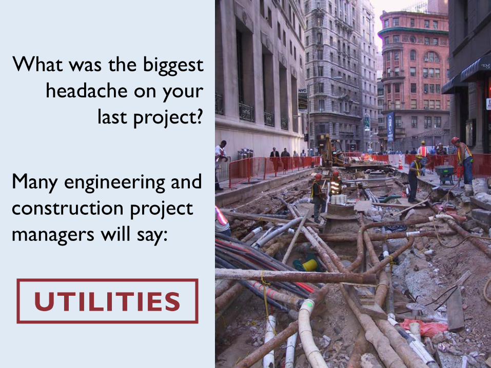
What was the biggest
headache on your
last project?
Many engineering and
construction project
managers will say:
UTILITIES
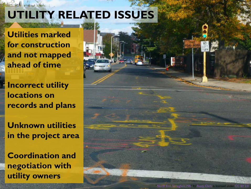
Utilities marked
for construction
and not mapped
ahead of time
Incorrect utility
locations on
records and plans
Unknown utilities
in the project area
Coordination and
negotiation with
utility owners
UTILITY RELATED ISSUES
“North End, Springfield MA” by Rusty Clark is licensed under CC BY 2.0

INCORRECT UTILITY LOCATIONS
Depth Slice Location
GPR Mapped Positionof Fuel Line
Records Positionof Fuel Line
Offset From Utility Records
~ 10 Feet
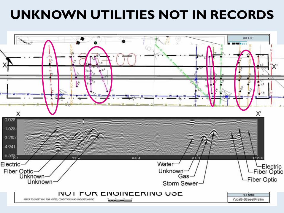
UNKNOWN UTILITIES NOT IN RECORDS

UNKNOWN UTILITIES:
Example From Pipeline Project
Less than one mile of
pipeline alignment
In a critical urban area
Found (not on records):
93 unknowns
9 traffic signal networks
5 storm drains
4 electric lines
4 gas lines
3 water lines
2 sanitary sewer lines

UTILITY IMPACTS ON DESIGN
Proposed structures that conflict with existing utilities
Unknown critical relocations
Design change orders during construction to deal with unanticipated
utility conflicts

UTILITY IMPACTS ON CONSTRUCTION
Construction change orders
Injuries and damages due to utility strikes
Cost and schedule overruns due to unanticipated utility issues
Coordination with utility owners

POP QUIZ #1
What are some of the impacts utilities pose during
design and construction?
Conflicts with proposed structures
Expensive relocation costs
Unknown/mis-mapped utilities increase risk to safety, schedule, & budget
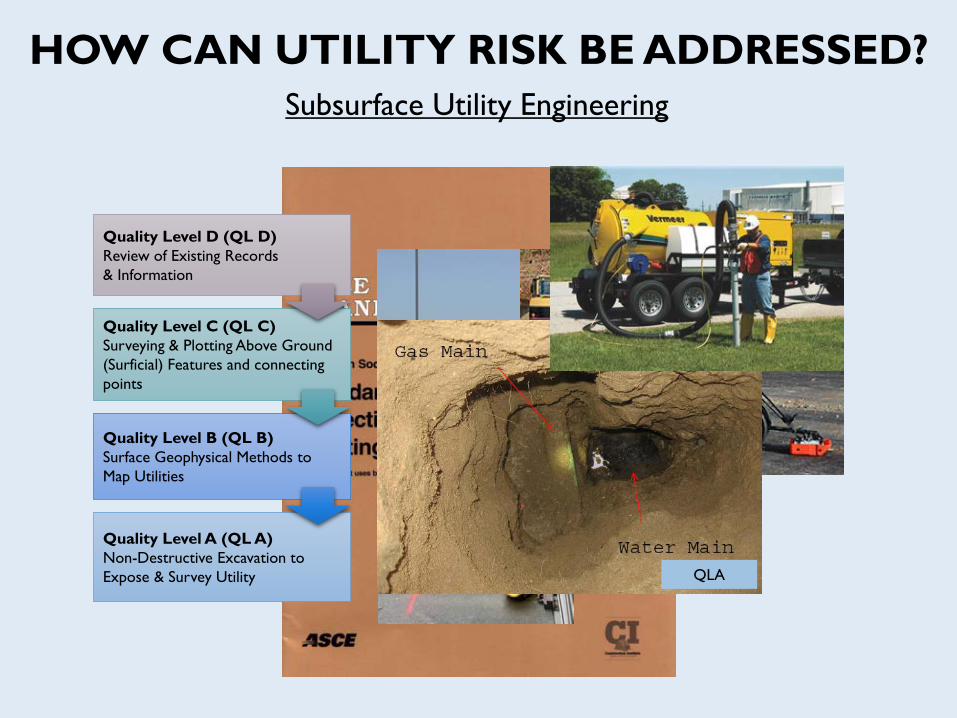
HOW CAN UTILITY RISK BE ADDRESSED?
Subsurface Utility Engineering
Quality Level D (QL D)
Review of Existing Records
& Information
QLD
Quality Level C (QL C)
Surveying & Plotting Above Ground
(Surficial) Features and connecting
points
QLC
Quality Level B (QL B)
Surface Geophysical Methods to
Map Utilities
QLB
Quality Level A (QL A)
Non-Destructive Excavation to
Expose & Survey Utility QLA

HOW CAN UTILITY RISK BE ADDRESSED?
Vacuum Excavate
Slot Trench
Entire Site
Investigate
Drawings
Call 811
Records
Lower Cost & Risk
with Utility Impact
Mitigation
HIGH
COST
LOW
COST
HIGH RISK LOW RISK
Vacuum
Excavate
Utility
Mapping
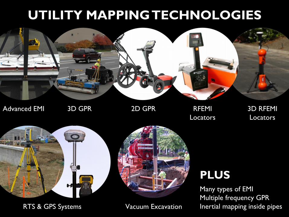
UTILITY MAPPING TECHNOLOGIES
RTS & GPS Systems Vacuum Excavation
3D GPR 2D GPR RFEMI
Locators
Advanced EMI 3D RFEMI
Locators
PLUSMany types of EMI
Multiple frequency GPR
Inertial mapping inside pipes

INVESTIGATION
AREA
EMI
FEATURES
GPR
FEATURES
UTILITY
DESIGNATIONFINAL
MAP
THE CASE FOR MULTIPLE SENSORS

POP QUIZ #2
What are some technologies & methods for mapping
utilities?
Existing records
Surface features
Electromagnetic/Radio Frequency Locators
Ground Penetrating Radar
Vacuum Excavation
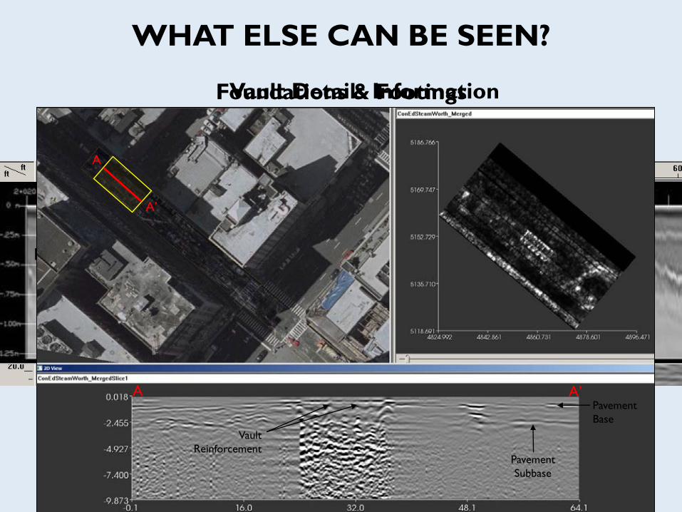
WHAT ELSE CAN BE SEEN?
Interpreted Top of
Bedrock
Soil Layering
Soil & Bedrock Information
Foundations & Footings
Information
Top of
Pavement Subbase Thickness
Pavement Thickness
Pavement Information
Vault Details Information
A
A’
A A’
Pavement
Subbase
Pavement
Base
Vault
Reinforcement

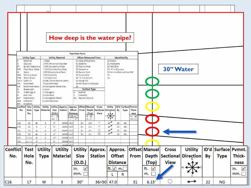
UTILITY CONFLICT MATRIX
BENEFITS
Systematic management of utility conflicts
Improved organization, tracking, and accountability
Cost estimate analysis spreadsheet
No IT support needed for single project matrix (Excel sheet)

PROJECT PLAN VIEW
30” Water18” Proposed
Drainage
Conflict?
COURTESY OF SHRP2
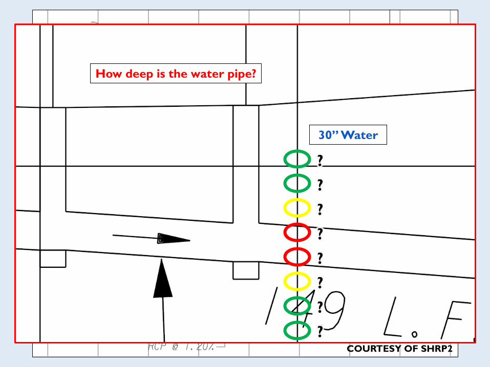
How deep is the water pipe?
30” Water
?
?
?
?
?
?
?
?COURTESY OF SHRP2
COURTESY OF SHRP2
How deep is the water pipe?
30” Water

ROSWELL ROAD PLAN VIEWUtility
Owner
ID Sheet
No.
Utility
Type
Size/
Material
Utility Conflict
Description
Start
Sta.
End
Sta.
Start
Offset
End
Offset
Inv.
Need
Test
Hole
Recommended
Action
Rsp.
Party
Est. Res.
Date
Res. Status Cost
Analysis
AWS C16 1 WM 30”
ductile
iron
pipe
Proposed 18”
drainage pipe
would cross WM.
36+50 47’ LT QLA 17 Review possibility of
adjusting drainage
pipe up to avoid
conflict.
U n/a Utility
conflict
identified.
C16
COURTESY OF SHRP2

UTILITY CONFLICT MANAGEMENT SUMMARY
COURTESY OF SHRP2
GOAL: Minimize Unnecessary Utility Relocations
Gather available info & perform preliminary field investigation
Identify potential utility conflicts
Prepare utility conflict matrix
Evaluate alternatives (both utility and project)
Conduct utility impact analysis
Coordinate with stakeholders
Iterative process (pending design progression)

POP QUIZ #3
How can Utility Conflict Matrices help during utility
coordination?
Provides management tool to deal with conflicts
Organizes relevant information on conflicts & alternatives
Allows tracking of conflict resolution progress

EXAMPLE:
DRAINAGE CHANNEL & ELECTRICAL DUCT
SYSTEM
Approximate centerline
of planned drainage ditch
COURTESY OF SHRP2
Rapid City, South Dakota
Impact discovered during
preliminary project scoping
inspection
Typical concrete lined drainage
ditch would have impacted
electrical cabinet and cables
Recommendation: Redesign
sloped ditch to vertical wall
Additional benefit: Elimination of
some right of way acquisition
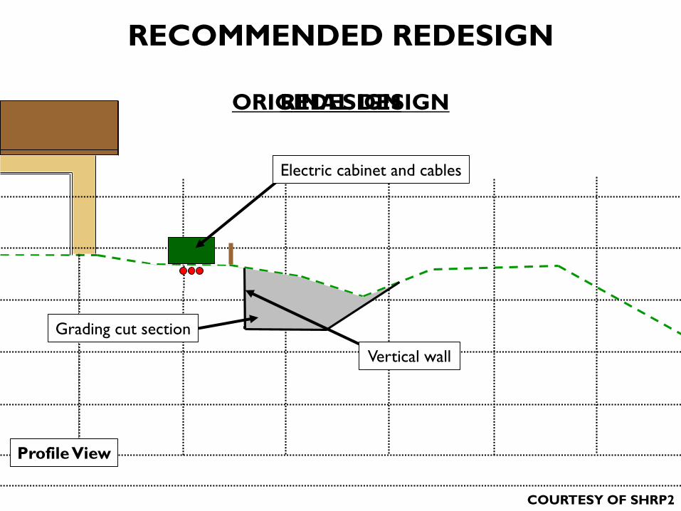
RECOMMENDED REDESIGN
Grading cut section
Vertical wall
Electric cabinet and cables
Profile View
COURTESY OF SHRP2
ORIGINAL DESIGNREDESIGN

COURTESY OF SHRP2

COURTESY OF SHRP2

Client’s Original
Boring Location
Clients Adjusted
Boring Location
INVESTIGATION AREA

CASE STUDY: MISSOURI RIVER WWTP
Existing utility data was
unreliable and incomplete
Potential for design conflicts,
construction delays and cost overruns
GOALS OF SUBSURFACE GEOPHYSICAL INVESTIGATION
Verify utilities in critical priority areas throughout the Project Site
Survey of proposed design areas to reduce design conflicts with
unknown or poorly mapped utilities
Reduce project costs and timeline by improved targeting of pot-
holing program

2D MAP OF EMI DATA OVER SEVERAL TARGETS

INVESTIGATION AND CONFIRMATION OF
TARGETS
Original Test Hole
Location #8
Adjusted Test Hole
Location #8
Confirmed Gas Line
Confirmed Water Main
Based upon the UIT
geophysical investigation
the location of the test
hole was adjusted.
Resulting in the
verification of two
previously unknown
utilities
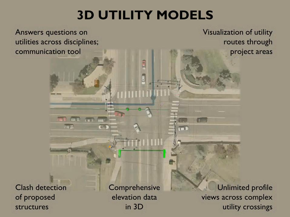
3D UTILITY MODELS
Answers questions on
utilities across disciplines;
communication tool
Visualization of utility
routes through
project areas
Clash detection
of proposed
structures
Comprehensive
elevation data
in 3D
Unlimited profile
views across complex
utility crossings

http://www.bentley.com/NR/rdonlyres/40E4D3F6-A48B-49CA-97C3-EE851900428B/0/SUEinfoin3DviewLarge.jpg
CLASH DETECTIONS
Can “automatically” create
preliminary Utility Conflict
Matrix
Construction Teams can run
tolerance checks to find
areas requiring test holes
Designers can check
proposed bridge, wall,
drainage, and other civil
structures for conflicts
Utility Engineers can run
proposed utility relocations
against existing utilities &
design structures

MODEL USE BY CONSTRUCTION
Construction Sequence Planning
Constructability checks
Easy utility reacquisition for staking or potholing before construction
Visualization in field for on the spot decisions

MACHINE GUIDANCE
2D maps available in
machine cab to inform
operator about utility
proximity

POP QUIZ #4
What are some benefits to a 3D utility model?
Can house all utility information on a project
Clash detections
Utility visualizations in field
Unlimited arbitrary profiles possible
Input into MCG systems

“Money” by 401(K) 2012 is licensed under CC BY-SA 2.0

Savings & Efficiency
With Good Utility Management
Test Hole Savings Mapping Efficiency
Project DataSavings
Factor
TOHO250/68 Test
Holes3.7
Omaha
WWTP
125/25 Test
Holes5
Large D/B
Project
$11MM/
$4MM2.75
Project Data Efficiency
TOHO1 miss/68
test holes98.5%
Omaha
WWTP
1 miss/25
test holes96.0%

POP QUIZ #5
Where do savings come from on Enhanced Utility
Management?
Redesign/realignment of proposed structures to avoid relocating
existing utilities during design phase
Number of test holes reduced
Fewer dry holes during intrusive investigations
Utility-related change orders reduced from encountering unknown
utilities during construction
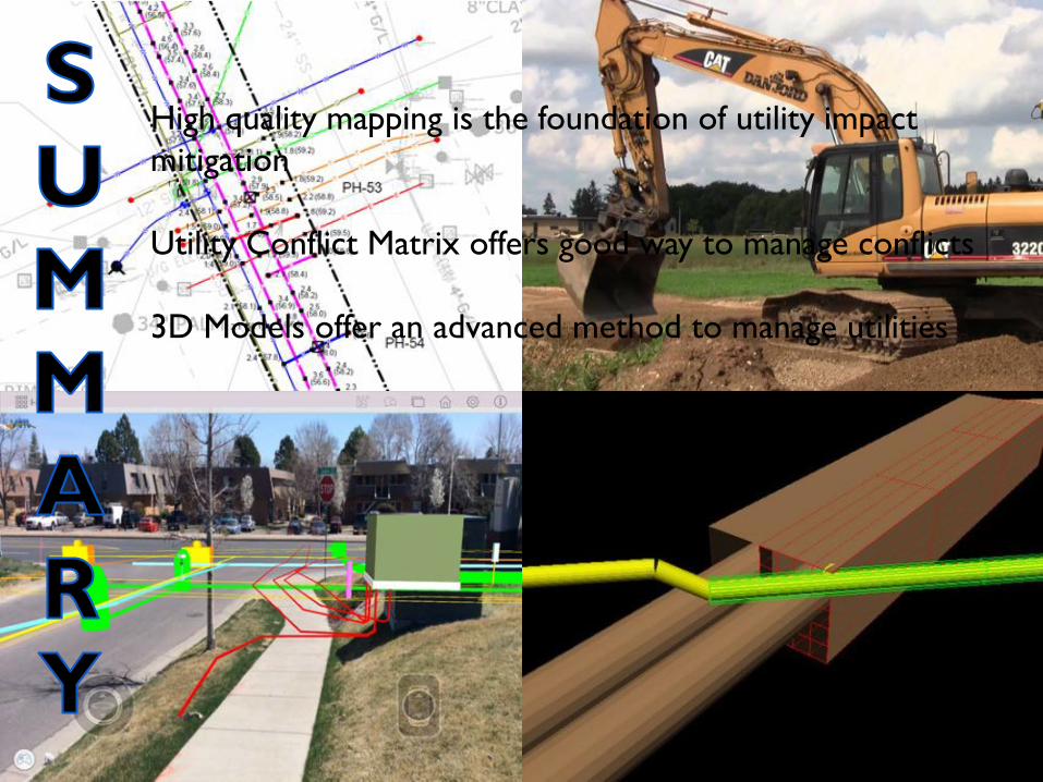
High quality mapping is the foundation of utility impact
mitigation
Utility Conflict Matrix offers good way to manage conflicts
3D Models offer an advanced method to manage utilities
Utility Impact Mitigation Lets You:
Design more efficiently
Construct more safely
Save money & reduce schedule delays