mississippi geology - mdeq.ms.gov · gernant and kesling (1966) delineated seven environ ... upon...
TRANSCRIPT

' THE DEPARTMENT OF NATURAL RESOURCES . . - -
miSSISSIPPI
•
Bureau of Geology 2525 North West Street Jackson, Mississippi 39216
geology Volume 4, Number 3
March 1984
PALEOENVIRONMENTAL RECONSTRUCTION OF THE VICKSBURG GROUP (OLIGOCENE) ,
WARREN COUNTY, MISSISSIPPI
Ramsey Fisher and
Kevin Ward Department of Geosciences Louisiana Tech University
Ruston, LA 71272
ABSTRACT
Foraminiferal communities found in the Vicksburg Group, Warren County, Mississippi, were controlled by the interplay of terrigenous sediments from the Mississippi Embayment and carbonates from the eastern carbonate bank. Paleoenvironmental reconstruction of the Vicksburg Group in Warren County reveals both transgressive and regressive sequences. The Gulf of Mexico transgressed from hypersaline and normal marshes of the Mint Spring into the shallow inner shelf seas of the Marianna and reached maximum transgression during the deep inner shelf seas of the middle Glendon Formation. Regression of the Gulf began in the shelf seas of the upper Glendon and continued into the normal and hyposaline lagoons and bays of the Byram Formation.
INTRODUCTION
Paleoenvironmental reconstructions of Gulf Coast formations based upon foraminifera have been useful in understanding the sedimentary history of the Gulf Coast. Although the Vicksburg has proven to be an important petroleum source group in Texas, little work has been done on the Vicksburg in Mississippi. Furthermore, little is known of the paleoecology of the Vicksburg Group in Mississippi.
The Vicksburg Group was studied at the Mississippi Valley Portland Cement Company quarry (NWY. Sec. 26, T18N, R4E), three miles northeast of Redwood, Mississippi, on Mississippi Highway 3. Samples were collected from the abandoned quarry across Highway 3 from the company's plant. The quarry represents the northwesternmost outcrop of the Vicksburg
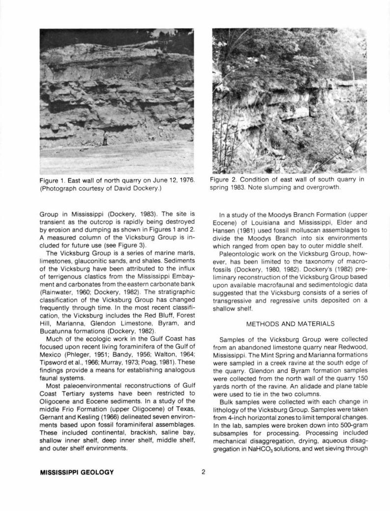
Figure 1. East wall of north quarry on June 12, 1976. (Photograph courtesy of David Dockery.)
Group in Mississippi (Dockery, 1983). The site is transient as the outcrop is rapidly being destroyed by erosion and dumping as shown in Figures 1 and 2. A measured column of the Vicksburg Group is included for future use (see Figure 3).
The Vicksburg Group is a series of marine marls, limestones, glauconitic sands, and shales. Sediments of the Vicksburg have been attributed to the influx of terrigenous clastics from the Mississippi Embayment and carbonates from the eastern carbonate bank (Rainwater, 1960; Dockery, 1982). The stratigraphic classification of the Vicksburg Group has changed frequently through time. In the most recent classification, the Vicksburg includes the Red Bluff, Forest Hill, Marianna, Glendon Limestone, Byram, and Bucatunna formations (Dockery, 1982).
Much of the ecologic work In the Gulf Coast has focused upon recent living foraminifera of the Gulf of Mexico (Phleger, 1951 ; Bandy, 1956; Walton, 1964; Tipsword et al., 1966; Murray, 1973; Poag, 1981). These findings provide a means for establishing analogous faunal systems.
Most paleoenvironmental reconstructions of Gulf Coast Tertiary systems have been restricted to Oligocene and Eocene sediments. In a study of the middle Frio Formation (upper Oligocene) of Texas, Gernant and Kesling (1966) delineated seven environments based upon fossil foraminiferal assemblages. These Included continental, brackish, saline bay, shallow inner shelf, deep inner shelf, middle shelf, and outer shelf environments.
MISSISSIPPI GEOLOGY 2
Figure 2. Condition of east wall of south quarry in spring 1983. Note slumping and overgrowth.
In a study of the Moodys Branch Formation (upper Eocene) of Louisiana and Mississippi , Elder and Hansen (1981) used fossil molluscan assemblages to divide the Moodys Branch into six environments which ranged from open bay to outer middle shelf.
Paleontologic work on the Vicksburg Group, however, has been limited to the taxonomy of macrofossils (Dockery, 1980, 1982). Dockery's (1982) preliminary reconstruction of the Vicksburg Group based upon available macrofauna! and sedimentologic data suggested that the Vicksburg consists of a series of transgressive and regressive units deposited on a shallow shelf.
METHODS AND MATERIALS
Samples of the Vicksburg Group were collected from an abandoned limestone quarry near Redwood, Mississippi. The Mint Spring and Marianna formations were sampled in a creek ravine at the south edge of the quarry. Glendon and Byram formation samples were collected from the north wall of the quarry 150 yards north of the ravine. An alidade and plane table were used to tie in the two columns.
Bulk samples were collected with each change in lithology of the Vicksburg Group. Samples were taken from 4-inch horizontal zones to limit temporal changes. In the lab, samples were broken down into 500-gram subsamples for processing. Processing included mechanical disaggregation, drying, aqueous disaggregation in NaHC03 solutions, and wet sieving through


(/) w ...J c.. ~ ~ (/)
L
K
J
H
G
F
E
D
c B
A
• Miliolina • Rotaliina A Textulariina
Byram
Glendon
Marianna
Mint Spring
0 25 50 75 100
% MILIOLINA, ROTALIINA, AND TEXTULARIINA Figure 4.
35 and 60 size U.S. mesh sieves. Limestone samples could not be disaggregated for microfossil analysis.
A Sepor Technical Supply Microsplitter was used to generate random, representative subsamples of material captured on the 60 size mesh sieves. Two 2QO-point counts based on generic level identifications were then made for each subsample. Genera counts were compared and their values averaged. Paleoenvironmental reconstructions were then proposed for each sample based on generic diversity counts, environmental preferences of genera, predominant genera, Shannon-Wiener Index values, general faunal trends, and the depositional history of the area.
DISCUSSION
The initial t ransgression of the Vicksburg Group occurred during the deposition of the Mint Spring,
MISSISSIPPI GEOLOGY 4
Marianna, and lower Glendon formations (samples A through G).
The Mint Spring is a dark gray, glauconitic, sandy, clayey marl that grades upward into a gray, clayey marl. Mil iolids and textulariids as shown in Figures 4 and 6 and Table 1 are common in the Mint Spring. Based on the marginal-nearshore habitat of miliolids and textulariids (Gernant and Kesling, 1966) and Murray's ( 1973) triangular plot (Fig. 6), the basal Mint Spring was deposited in slightly hypersaline marshes. Drop in miliolid and textulariid occurrence (Fig. 4), increase in faunal diversity (Fig. 5) , and increase in shelf rotaliids (Fig. 4 and Table 1) suggest gradation of the upper Mint Spring (sample B) into seaward, normal marine marshes and associated nearshore shallow inner shelf environments (Bandy and Arnal, 1960; Gernant and Kesling, 1966).
Transgression of the Gulf continued during deposition of the Marianna Formation, a tan-gray, limy

0
N
M
l
K
J
(/) H w ..J G ~ ~ F ~
E (/)
D
c B
A
2.1
SHANNON
2.3
Byram
Marianna
Mint Spring
2.5
WIENER INDEX (•)
Figure 5. Plot of generic diversity (Shannon-Wiener Index) for Vicksburg samples.
mudstone that grades into an indurated limestone. Common shelf foraminifera of the Marianna (i.e., Cibicides, Eponides, Siphonina, and Textularia; see Table 1) indicate deposition of the Marianna in a normal marine, shallow ( < 10 meters) inner shelf environment (Murray, 1973; Gernant and Kesling, 1966). The calcareous nature of the Marianna suggests increased influence of the eastern carbonate bank on sediments deposited in the Mississippi Embayment.
Water depth continued to increase during deposition of the lower Glendon Formation. The Glendon Formation is a series of indurated, massive, arenaceous, ledge-forming limestones and poorly indurated marls (see Fig. 3). Continued increase of shelf rotaliids and decrease of miliolids and textularilds (Table 1 and Fig. 4) suggest deposition of the lower Glendon in inner shelf environments (10-20 meters). Sample E of the lower Glendon, based on increased faunal diversity (Fig. 5) and shelf rotaliids (Tables 1 and 2), is probably a deep inner shelf environment (20 meters) (Murray, 1973; Gernant and Kesling, 1966; and Tipsword et al., 1966) and represents a major transgression of the Gulf during Vicksburg times.
5
Faunal diversity variations (Fig. 4) and fluctuations in genera (Table 1) in the middle and upper Glendon (samples F-1) are probably due to the interplay of terrigenous sediments of the Mississippi Embayment and carbonates of the eastern carbonate bank and their influence on Vicksburg foraminifera.
The occurrence of shelf foraminifera (Tables 1 and 2) in the middle and upper Glendon suggests deposition in deep inner shelf environments (Murray, 1973; Gernant and Kesling, 1966; Tipsword et al., 1966). Sample I in the upper Glendon is marked by the highest faunal diversity (Fig. 5) in the Vicksburg, indicating a high degree of environmental stability characteristic of more open shelf environments.
After deposition of sample I, the Gulf began a regression that resulted in the deposition of the upper Glendon and Byram formations. A change in marine sedimentation occurred during this regressive sequence as evidenced by the change from Glendon limestones to overlying Byram sandstones and clays. During deposition of the Byram, terrigenous sediments from the ancestral Mississippi River became the chief sediments in the Mississippi Embayment as the eastern carbonate bank retreated southeastward. The upper limestone ledge of the Glendon represents the last major influence of the eastern carbonate bank on Vicksburg sediments of Warren County, Mississippi.
The change to terrigenous sediments from carbonates may represent an eastward shift of the ancestral Mississippi River during Oligocene times. With regression of the Gulf, deposition of terrigenous sediments, and possible shifting of the Mississippi River, the Byram was deposited in restricted environments.
The abundance of Quinqueloculina and Textularia (Table 1 and Fig. 4) in the Byram and low faunal diversity (Fig. 5) suggest nearshore and marginal marine environments (Murray 1973; Gernant and Kesling, 1966; Tipsword et al., 1966). Samples J, K, and L were collected from a sandstone unit in the lower Byram (see Fig. 3). The sand is believed to have been deposited seaward of a bay environment as offshore bars in a shallow shelf sea ( < 5 meters). The presence of horizontal Ophiomorpha burrows (from the Callianassa shrimp) in this sandstone unit further indicates a shallow, subtidal marine environment.
The middle Byram (samples M and N) was deposited landward of the offshore sand bars in low energy, restricted bays and lagoons. Evidence for lagoonal deposition is the occurrence of Textularia and Quinqueloculina (Table 1) and the abundance of carbonaceous clay and silt in the sample (Murray, 1973; Gernant and Kesling , 1966; Tipsword etal., 1966). Clay and silt accounted for 99.7% and 96.7% of the weight of samples M and N, respectively.
MARCH 1984

Samples
A B C D E F G H I J K L M N 0
Rotaliina
Anomalina R R R R R 0 R R R R R R R R R
Amphistegina R R R R R R R R 0 0 R R R R R
Asterigerina R R R R 0 R R R 0 R 0 R R 0 C
Cibicides C 0 C A A C C A C 0 0 0 0 R A
Discorbis R R R R R R 0 R R R R R R R R
Eponides 0 C C C C C 0 R C 0 0 0 R 0 R
Globigerina R R R R R R R R R R R R R R R
Guttulina R R R R R R 0 R 0 R R R R R R
Lenticulina R R R R 0 0 0 R R R R R R R R
Nonionella R 0 R R R 0 R R R R R R R R C
Non ion R 0 R R R R R R R R R R R R R
Polymorphina R R 0 0 0 C 0 R 0 R R R 0 0 R
Reusella R R R R R R R R R 0 R R R R 0
Rotalia R R R R R R R R R R R R R R 0
Siphonia 0 0 C C C C C C C R R R C 0 R
Miliolina
Pyrgo R R R R R R R R R R R R R R R
Massilina R R R R R R R R R R R R 0 0 R
Quinqueloculina C C 0 R R R 0 R 0 A A A C C R
Textulariina
Clavulina 0 0 0 R R R R R R R R R R R R
Textularia A C A C 0 0 C C C A A A A A R
Table 1 Percent occurrence of foraminifera genera by sample. Rare (R} = < 5.0%; Occasional (0} = 5.0-9.9%; Common (C) = 10.0-19.9%; and Abundant (A) = > 20.0%.
MISSISSIPPI GEOLOGY 6

inner middle outer marginal shelf shelf shelf slope
Rotaliina
Anornalina
Arnphistegina
Asterigerina
Cibicides
Discorbis
Eponides
Globigerina
Guttul i na
Lenticulina
Nonionella
Non ion
Polyrnorphina
Reus ella
Rot alia
Siphon ina
Miliolina
Pyrgo
Massilina
Quinqueloculina
Textulariina
Clavulina
Textularia
Table 2 Environmental preferences of genera. Thickest dark lines indicate.greatest preference for that environment for that genus. Based upon reports from Bandy (1956), Bandy and Arnal (1960) , Gernant and Kesling (1966), Murray (1973) , Phleger (1951 ), Poag (1981), Tipsword et al. (1966), and Walton (1964).
7 MARCH 1984

MILIOLINA
hypersaline marshes (whole triangle)
hypersaline lagoons
normal marine lagoons
shelf
hyposallne ""~ lagoons ~
Figure 6. Plot of Vicksburg samples on Murray's (1973) Triangular Diagram showing environmental preference for various percentages of the suborders Miliolina. Rotaliina, and Textulariina.
Regression continued during deposition of the upper Byram (sample 0). Rotaliid tests, especially Cibicides, in this sample were smaller than tests from previous samples. indicating fresh water influx (Walton, 1964). Sample 0 also had the highest faunal dominance of any sample (Cibicides = 33% of fauna). This suggests that sample 0 is the most nearshore marginal environment sampled in the Vicksburg Group in Warren County, Mississippi (Gernant and Kesling, 1966). Based on the above information and the faunal assemblage of sample 0 (Table 1), the upper Byram was probably deposited in a shallow ( < 3 meters). low energy, hyposaline lagoon.
Tipsword et al. (1966) suggest continued regression of the Gulf through the Bucatunna Formation (Vicksburg Group) and into the Catahoula Group. Bucatunna sediments that were deposited in Warren County, Mississippi, were probably removed by erosion during Catahoula time.
CONCLUSION
Paleoenvironments of the Vicksburg Group of
structed from fossil foraminiferal assemblages, indicate deposition of the Vicksburg in transitional to deep inner shelf environments. Paleoenvironments of the Vicksburg Group were determined as:
1. Mint Spring - hypersaline to normal marine marshes;
2. Marianna - shallow inner shelf; 3. Glendon - deep inner shelf; 4. Byram - normal bay/ lagoon to hyposaline
lagoon. The Vicksburg consists of a cyclical sequence of
transgression (Mint Spring to upper Glendon) and regression (upper Glendon through Byram).
Sediments and fauna of the Vicksburg Group were greatly influenced by the Mississippi Embayment and eastern carbonate bank. The interplay of these two systems resulted in the formation of marls, clays. limestones. and sands known collectively as the Vicksburg Group.
ACKNOWLEDGMENTS
northeastern Warren County, Mississippi, as recon- The authors would like to thank the following for
MISSISSIPPI GEOLOGY 8

their assistance: Anderson Tully Industries for allowing the authors to work in the Mississippi Valley Portland Cement Quarry; David Dockery for suggestions and use of his photograph; Johnie Owens for typing the original manuscript; and the Louisiana Tech Department of Geosciences for use of lab equipment. Special thanks to Brian Whatley for drafting the stratigraphic column of the Vicksburg Group and to Dr. Gary Zumwalt of Louisiana Tech for his suggestions and constant support.
REFERENCES CITED
Bandy, O.L., 1956, Ecology of foraminifera in northeastern Gulf of Mexico: U.S. Geological Survey, Professional Paper 274-G, p. 179-204.
Bandy, O.L., and R.E. Arnal , 1960, Concepts of foraminiferal paleoecology: American Association of Petroleum Geologists Bulletin, v. 44, no. 12, p. 1921-1932.
Dockery, D.T., 1980, The invertebrate macropaleontology of the Clarke County, Mississippi, Area: Mississippi Bureau of Geology, Bulletin 122, 387 p.
Dockery, D.T., 1982, Lower Oligocene Bivalvia of the Vicksburg Group in Mississippi: Mississippi Bureau of Geology, Bulletin 123, 261 p.
Dockery, D.T., 1983, personal communication. Elder, S.R., and T.A. Hansen, 1981 , Macrofossil assem
blages of the Moodys Branch Formation (Upper Eocene), Louisiana and Mississippi : Gulf Coast
Association of Geological Societies Transactions, v. 31, p. 283-287.
Gernant, R., and R.V. Kesling, 1966, Foraminiferal reconstruction of the Oligocene Middle Frio in Chambers County, Texas: Gulf Coast Association of Geological Societies Transactions, v. 16, p. 131-158.
Murray, J.W., 1973, Distribution and ecology of living benthic foraminiferids: Heineman Educational Books, 274 p.
Phleger, F.B., 1951, Ecology of foraminifera, northwest Gulf of Mexico, Part 1, Foraminifera distribution: Geological Society of America, Memoir 46, p. 1-88.
Poag, C.W., 1981, Ecologic atlas of benthic foraminifera of the Gulf of Mexico: Marine Science International , Woods Hole, Mass., 174 p.
Rainwater, E.H., 1960, Stratigraphy and its role in the future exploration for oil and gas in the Gulf Coast: Gulf Coast Association of Geological Societies Transactions, v. 10, p. 33-75.
Tipsword, H.L., F.M. Setzer, and F. Smith, 1966, Interpretation of depositional environments in Gulf Coast petroleum exploration from paleoecology and related stratigraphy: Gulf Coast Association of Geological Societies Transactions, v. 16, p. 119-130.
Walton, W.R., 1964, Recent foraminiferal ecology and paleoecology, in Imbrie, J., and N. Newell, eds., Approaches to paleoecology: John Wiley and Sons, Inc., New York, p. 151-237.
MISSISSIPPI OIL AND GAS STATISTICS, THIRD QUARTER 1983
July August September
Totals
July August September
Totals
Bbls. Produced 2,818,524 2,723,408 2,656,819
8,198,751
MCF Produced 14.402,927 16,292,140 14,587,633
45,282,700
Oil
Severance Tax $ 4,444,570.49
4,336,879.00 4,173,764.90
$12,955,214.39
Gas
9
Severance Tax $ 3,735,101.48
4,018,817.99 2,881, 704.26
$10,635,623.73
Average Price Per Bbl. $26.28 26.54 26.18
$26.33
Average Price Per MCF $ 4.32
4.11 3.29
$ 3.91
Source: State Tax Commission
MARCH 1984

NEW BUREAU OF GEOLOGY PUBLICATION
ECONOMIC MINERALS MAP OF MISSISSIPPI, 1983
The Bureau of Geology announces the publication, in conjunction with the Mississippi Mineral Resources Institute, of the Economic Minerals Map of Mississippi, 1983, compiled by David C. Booth and Darrel W. Schmitz. Both Mr. Booth and Mr. Schmitz are currently geologists with the Bureau of Geology.
This is a 1:500,000 scale color map of mineral occurrences and production within the State of Mississippi that was compiled from published and unpublished information of the Mississippi Bureau of Geology, the Mississippi Research and Development Center, the Mississippi Mineral Resources Institute, the State Oil and Gas Board, the United States Bureau of Mines, and the United States Geological Survey. Individual map colors delineate generalized areas of principal occurrence for a variety of mineral deposits. A brief description of each specific mineral type and the for-
mations or portions of formations in which potential economic mineral deposits may be located is included. Active mines and plants for those minerals presently being utilized are shown on the map, as well as former mine and plant locations for those minerals not presently produced within the state. A small generalized geologic map and a structural features map are included for reference.
This map may be purchased from the Bureau of Geology at 2525 North West Street for $4.00 per copy. Mail orders will be accepted when accompanied by payment (4.00, plus $1.25 postage and handling).
Address mail orders to: Bureau of Geology P.O. Box 5348 Jackson, Mississippi 39216
CALENDAR OF EVENTS
1984 April - June
April 4-6 - North-Central and Southeastern sections, Geological Society of America, ann. mtgs., Lexington, Kentucky. (Donald C. Haney, Kentucky Geological Survey, 311 Breckinridge Hall, University of Kentucky, Lexington, Ky. 40506. Phone: 606/ 257-5863)
May 14-18- American Geophysical Union, spring mtg, Cincinnati. (AGU headquarters, 2000 Florida Ave. NW, Washington, D.C. 20009. Phone: 202/462-6903)
May 20-23 - American Association of Petroleum Geologists and Society of Economic Paleontologists and Mineralogists, ann. mtg, San Antonio. (Walter W. Coppinger, Dept. of Geology, Trinity
MISSISSIPPI GEOLOGY 10
University, San Antonio, Texas 78284. Phone: 512n36-7654)
May 23-25 - Ground-water monitoring, symposium, Columbus, Ohio. (Kathy Butcher, National Water Well Association, 500 W. Wilson Bridge Road, Worthington, Ohio 43085. Phone: 614/846-9355)
May 24-29 - American Association for the Advancement of Science, ann. mtg, New York. (AAAS headquarters, 1776 Massachusetts Ave. NW, Washington, D.C. 20036. Phone: 202/467-4400)
June 4-7- World Oil and Gas, mtg, Dallas. (Martin C. Dwyer Inti., 1350 E. Touhy Ave., Des Plaines, Illinois 60018. Phone: 312/299-9311)

REPLY TO A REVISION OF THE HATCHETIGBEE AND BASHI FORMATIONS
David T. Dockery, Ill Mississippi Bureau of Geology
Charles W. Copeland, Jr. Geological Survey of Alabama
Paul F. Huddlestun Georgia Geologic Survey
INTRODUCTION
This article is in reply to a revision of the Hatchetigbee and Bashi formations by Gibson (1982). Gibson made a formal proposal to raise the Bashi from the rank of a member of the Hatchetigbee Formation to the rank of formation. He also redefined the Bashi and Hatchetigbee as equivalent lateral facies of downdip marine and updip nonmarine origin respectively. The recognition of the Bas hi as a formation is not new. This is the procedure followed by the Mississippi Bureau of Geology [Foster (1940) and Dockery (1980, 1981)] for the Bashi in Mississippi, where its lithology indicates a very different depositional environment from that of the overlying Hatchetigbee Formation. Also, the equal rank of formation follows more closely the definition given by the original authors, Smith and Johnson (1887), and solves the problem of having an unnamed upper member without the add ition of another stratigraphic term. The Geological Survey of Alabama, however, maintains the status of the Bashi as a member of the Hatchetigbee Formation based on the premise that the Bashi is too thin to serve as a mappable lithologic unit. If recognized as a formation , the Bashi still must be included with the Hatchetigbee Formation on a geologic map. The problem of concern with Gibson's revision is not in the status of the Bashi but in its redefinition to include marine beds previously assigned to the Hatchetigbee Formation, even at the Hatchetigbee type locality.
REVIEW OF THE TERMS BASH! AND HATCHETIGBEE
The Hatchetigbee and Bashi were originally named by Smith and Johnson ( 1887) as the upper two series in the Lignitic Formation, a name no longer in use. This formation was divided into seven series on the
11
basis of prominent marine marker beds, the upper four and lower three of which are now placed in the Wilcox and Midway groups respectively. The Hatchetigbee, the uppermost series of the Lignitic Formation, was named for the marine and nonmarine beds exposed at Hatchetigbee Bluff on the Tombigbee River. This unit was originally defined to include the interval between the Buhrstone Formation (Tallahatta Formation) and the Wood's Bluff fossiliferous beds (Bashi "Series") . Smith and Johnson (1887, p.40) gave the following lithologic description of the Hatchetigbee: 'The distinctively marine deposits of this series consist of three or four shell or marl beds, separated by non-fossilife.rous sands and clays (Plate V)" (see Plate V in Figure 1).
The Bashi Series, also called the Wood's Bluff Series, was named for marine beds exposed along Bashi Creek. Other exposures given for the Bashi were at Wood's Bluff on the Tombigbee River (Figure 2) and Yellow Bluff Landing on the Alabama River (Figure 3). Smith and Johnson (1887, p. 43) recognized the Bashi as the first marine beds of any consequence below the brown and purple clays of the Hatchetigbee Series at the previously mentioned Bashi localities. They described these marine beds as follows: "They are from 15 to 20 feet in thickness, are highly fossiliferous, hold a very considerable percentage of greensand, and the marl has a tendency to become indurated by carbonate of lime into rounded, bowlder-like masses of glauconitic fossiliferous limestone." Included with these beds in the Bashi Series was an underlying sequence of nonmarine beds that is now recognized as the upper part of the Tuscahoma Formation. This latter sequence, however, is not exposed at the type locality on Bashi Creek or at the section cited at Wood's Bluff. Figure 2 shows the boulders of the Bashi (greensand marl of bed no. 5) to crop out on a broad bench exposed just above water level at a lowstageoftheTombigbee River.
MARCH 1984

a-L! .. t7I !'l NO. 43 PL V
!1. Lowu part or purpli.<b bro,.,, sandy c!a)'ll. e. Ydlo•·i.<b gray l!&llds. 7 Blulsb bro,.·n. '"''>d.Y marl.
Figure 1. !Tbe buman ngure SI&Ddll upoa tbe bod ••bleb we call tbe mlddlo m&rl. lkr•"'•ceo azoe 1<> tbo oectloru< on p. ~J. and •loo 1<> Fig. 2 or Plat• X\' .)
HATCHETIGBEE-UPPER END OF BLUF F, TOMBIGBEE RIVER
0 a. G!.OLOOIC.t.L 801\VET 817LL~'T'TN NO. t3 Pt. V I
1. Dark a-ray cl&yl". "/. Blui""h· K&ndy day. ft~lllft·rou-1!1 3. Btu.k.b. tiA.IldY day, non ·f~ift>rou~ 4. ON"'tnl~. R&r'uly clay, hiJithly f~sJHfe-roUJi. 5. Greelll!Aild marl
tTbc ftgol ..... ,..,r.r to -'I""" OD p. ... aod....., U> tbe oectloo gtveo In Fig. 7 or p &Ul X\'1 I
w OOD' S BI.U"F, LQQKINO f)QWN THE TQII9°GflEE RIVER Figure 2.
MISSISSIPPI GEOLOGY 12

0 . 8. GEOLOOlCil BORVET Bot.LETIN NO. 43 Pt.. VtT
.... - - -. ~ --~
- ----·
---- ::--=-~- .-=....•
. ---- ... -=~-· -- ---- ~----=-- :...
Figure 3. Y ELI_OW BLU I'F LANDING, ALA BA MA RIVER.
A formational status was given to the Bashi by Foster (1940), who mapped it into eastern Mississippi and also included part of the Tuscahoma Formation within its limits. Toulmin (1944) restricted the Bashi Formation to a section of "fossiliferous marine greensand marl," 6 to 20 feet thick in western Alabama and 40 or more feet thick in eastern Alabama. MacNeil (1944) first proposed that the Bashi be allocated to a member status in the Hatchetigbee Formation, the position presently accepted by the Geological Survey of Alabama.
PROBLEMS WITH THE REVISION OF GIBSON
After proposing formational status for the Bashi, Gibson (1982) proceeded to redefine the lithologic characteristics of the Hatchetigbee Formation based on updip exposures along the outcrop belt in Alabama and Georgia but without including certain lithologies that occur at its type locality at Hatchetigbee Bluff. Such a redefinition is incorrect according to the North American Stratigraphic Code (1983, p. 856) , which states, "The definition and name of a lithostratigraphic
13
unit are established at a type section (or locality) that. once specified, must not be changed." Gibson's redefinition (1982, p. H33-34) recognizes for the Hatchetigbee only those lithologies that lack or have minor amounts of fossiliferous, marine sediments. He reserves all extensively fossiliferous, marine sediments for the Bashi Formation. However, as pointed out above, the type locality for the Hatchetigbee contains several very fossiliferous marine beds. In Gibson's redescription of the type locality, these marine beds now belong to the Bashi Formation so that beds 2, 3, 5, 6, 8, and 9 of the type section (see Figure 4) described by Smith and Johnson (1887, p. 40-41) and reprinted in Smith, Johnson, and Langdon (1894, p. 149-150) belong to the Hatchetigbee Formation and beds 4, 7, and 10 are placed in the Bashi Formation. The reasoning behind this redescription of the type is that the type locality, situated near the crest of the Hatchetigbee Anticline, is downdip from the "typical" facies of the Hatchetigbee exposed along the outcrop belt. Since the nonfossiliferous or sparsely fossiliferous beds of the Hatchetigbee Formation (as redefined) must grade downdip into equivalent marine beds of
MARCH 1984

•J n f1E0t.OO!CAL flT'}J\"7F.7
.: ... ...
" .. ... ... :I
-'
• .. 1-
X
~
t~lo ; ! meb • t il fe.~ t..
BOLLETJN NO. t3 PL XV
~
.. z 0
•
HATCHET IGBEE SECl JON OF TH E LIGNITIC, WITH PARTS O F TH E BUHRSTONE A ND
Figure 4. W OOD 'S BLUFF.
MISSISSIPPI GEOLOGY 14

the Bashi Formation (as redefined), then the downdip exposure at the type locality shows the interfingering of these two formations.
The redefinition of the Bashi and Hatchetigbee formations by Gibson, besides being incorrect according to the North American Stratigraphic Code, causes another problem. That is the alternation in a vertical sequence of the formal stratigraphic terms Bashi and Hatchetigbee, and this would occur even at the type locality of the latter.
PROPOSED RESTRICTION OF THE TEAM BASHI
It is herein proposed that the lithostratigraphic concept of the term Bashi, whether used as a separate formation or as a member of the Hatchetigbee Formation, be restricted to the concretionary, fossiliferous, marine sand and clayey sand (as typified at the type locality on Bashi Creek) between the nonfossiliferous sands of the upper Tuscahoma Formation and the nonfossiliferous sands and silts of the immediately overlying Hatchetigbee. This definition is the same as that given by Toulmin (1944). The Hatchetigbee Formation (exclusive of the Bashi Formation or Member) is here considered as the non fossiliferous to fossiliferous (marine) sands, silts, and clays including the first nonfossiliferous or very sparsely fossiliferous bed above the Bashi or, if that facies is absent, above the Tuscahoma Formation, and all other beds below the Tallahatta Formation or, if present, the Meridian Sand. In a depositional model for the Bashi-Hatchetigbee sequence, the Bashi represents the initial and most prominent marine transgression. It is followed by a regression in the Hatchetigbee that is punctuated by several marine incursions of a lesser order. If the Bashi and Hatchetigbee cannot be separated in downdip areas where this sequence Is entirely marine, then it Is recommended that the interval be referred to as Bashi-Hatchetigbee undifferentiated. This concept of the Bashi and Hatchetigbee is very close to that of the original authors, Smith and Johnson (1887) , who established these units on the basis of the marine beds and fauna which they contained.
15
ACKNOWLEDGMENTS
The authors are thankful to the following individuals who read this paper and gave constructive criticisms: Ernest A. Mancini, Geological Survey of Alabama: Joseph E. Hazel, Amoco Production Company, Tulsa, Oklahoma; and Lauck W. Ward, U.S. Geological Survey, Reston, Virginia.
REFERENCES CITED
Dockery, David T., Ill, 1980, The invertebrate macropaleontology of the Clarke County, Mississippi, area: Mississippi Bureau of Geology, Bull. 122, 387 p., 35 text fig., 62 pl.
Dockery, David T .. Ill, 1981, Stratigraphic column of Mississippi : Mississippi Bureau ot Geology, 1 sheet.
Foster, Vellora M., 1940, Lauderdale County mineral resources-geology: Mississippi Geological Survey, Bull. 41 , p. 1-172.
Gibson, Thomas G., 1982, Revision of the Hatchetigbee and Bashi Formations (Lower Eocene) in the Eastern Gulf Coastal Plain: U.S. Geological Survey, Bull. 1529-H, p. H33-41 , fig. 1 G-11 .
MacNeil, F. Stearns, 1944, The Tertiary formations {Georgia) : Southeastern Geological Society {Guidebook) 2nd Field Trip, p. 21-37.
North American Stratigraphic Code, 1983: American Association of Petroleum Geologists Bull. , v. 65, no. 5, p. 841-875.
Smith, Eugene A., and Lawrence C. Johnson, 1887, Tertiary and Cretaceous strata of the Tuscaloosa, Tombigbee, and Alabama Rivers: U.S. Geological Survey, Bull. 43, 189 pl., 21 pl.
Smith, Eugene A., Lawrence C. Johnson, and Daniel W. Langdon, Jr., 1894, Report on the geology of the coastal plain of Alabama: Geological Survey of Alabama, Special Report no. 6, 758 p., 24 pl.
Toulmin , Lyman D., Jr., 1944, General features of the Tertiary formations in Alabama: Southeastern Geological Society (Guidebook) 1st Field Trip, p. 5-15.
MARCH 1984

MISSISSIPPI GEOLOGY Department of Natural Resources Bureau of Geology Post Office Box 5348 jackson, Mississippi 39216
Mississippi Geology is published quarterly in March, june, September, and December by the Mississippi Department of Natural Resources, Bureau of Geology. Contents include research articles pertaining to Mississippi geology, news items, reviews, and listings of recent geologic literature. Readers are urged to submit letters to the editor and research articles to be considered for publication; format specifications will be forwarded on request. For a free subscription or to submit an article, write to:
Editor, Mississippi Geology Bureau of Geology
P. 0. Box 5348 jackson, Mississippi 39216
Editors: Michael B. E. Bograd and David Dockery