:?mis0. ralph j. melancon - bsee data center · ocs-g 7014 soi fr- tp ocs-g 5900 «t-i i soi 108...
TRANSCRIPT

i n Reply Refer To: RP-2-i
Shell Offsho Inc. At tent ion: ^ r . G. i i . Meg> l igan Post Off ice Iiox 6015p» Mem Qr le tn* , Louisiana 70160
Gentleaen:
Refer****: is N C r.o your I n i t i a l Oevelop*rnt Operatic—: i.»x>r\'1 • «n Oov•atosf (OOCD) and Envlronaental . eport received June '9«r, *w U.<»'*» . C-G 5.V19, SyoO, and 7005, Blocks 65, ICO, and 64, respectively, jreen Cinyw Area, 'n is OOC; Includes thc ac t i v i t i es proposed for Platfona > l ' s '. througi; 0 rffll? thnugh W, and Wells ft throuqh Y.
In accordance with 30 CFR 250.34, r#vis<.-d Decenber 13, 197?, . ; f c t l ce Lessees and Operators >io. 84 -1 , th is DOCO has been detenatecd tu % * empl, t«-as >f July 2, 1965, and H now being considered for approval.
Youi* control nur&or is N-2161 and should be ref^?-»nced in your c ice* «o<» and correspondence concerning th is OOCD.
Sincerely yours.
:?MIS0. RALPH J. MELANCON 0. vi. Solanas Regional Supervisor Rules and Production
bcc: Lease OCS-G 58RQ (0P3-3-2) (FILE ROOM) Lease OCS-C 5900 (OPS-3-2) (FILL ROOM) Lease XS-G 7005 (OPS-3-2) (FILE ROOM)
LPPS-3-4 W/Publlc In fo . Copy of the DOCO and ER (PUBLIC RECOROS ROOM) DO-6
MJTo1bert:ocw:7/2/85 Disk 3a

Shell Offshore Inc. A SubS)Our> C S'-e-' OH C c i p a ' . y
r - .60.-9 ••a-s Lc _ s a-a "0.160
Of'shore East Production Division
m n gas
Regional Supervisor Rules and Production Minerals Man«-$ement Service P. 0. Box 7944 Metairie, LA 70010
Dear S i r : K w a tutwenoa
SUBJECT: DEVELOPMENT OPERATIONS COORDINATION DOCUMENT SOI OCS-G 7005, GREFN CANYON BLOCK 64 SOI OCS-G 5889, GREEN CANYON ELOCK 65 SOI OCS-G 5900, CRED. CANYON BLOCK 109 CREEN CANYON BLOCK 65 FIELD OFFSHORE LOUISIANA
Shell Offshore Inc. (SOI) herewith submits for your approval an i n i t i a l Development Operations Coordination Document (DOCD) for the captioned leases. Shell plans to develop tiiese leasss with a combination drilling/production platform to be located on Block 65.
This plan i s submitted in accordance with 30 CFR 250.34, effective December 13, 1979, and subsequent guidelines.
This plan consists of a series of att ments describing details of our intended operations. The attachments chat we desire to be exempted from disclosure under the Freedom of Information Act are marked "Confidential."
A search for cultural resources prior to d r i l l i n g i s not required for the captioned leases.
D r i l l i n g and other operations w i l l be conducted under the applicable provisions cf OCS Orders and other regulations, orders and notices including those re^Trding the avoidance of potential d r i l l i n g hazards. Safety and. pollution prevention and control w i l l be prime considerations during a i l operations.
l-.'e would appreciate your consideration of our DOCD as soon as possible in view of tlie requirements of the Platform Verification Program (OCS Order No. 6). Construction of the platform may begin in June 1985. I t is imperative chat the commencerrtnt of the fabrication not be delayed in order to meet the target i n s t a l l a t i o n date in 1988.
nut w**^
o 4 |955
LC851340-iW

2
Should you require additional information, please contact A. R. Pickett at (504) 588-0198 or 588-6312.
Yours very t r u l y ,
Production Administration Manager
ARP:WG
Attachments
cc: (v/attachments) District Supervisor Houma District Minerals Management Service P. 0. Box 10145 Houma, CA 70361
I.C8513404W
G. .n- Megllllgan

INDEX OF ATTACHhi.fr fS DEVELOPMENT OPERATIONS COORT7NATION DOCUMENT
SOI OCS-G 7005, GREEN CA..:ON BLOCK 64 SOI OCS-G 5889, GREEN CANYON BLOCK 65 SOI OCS-G 5900, GREEN CANYON BLOCK 109
GREEN CANYON BLOCK 65 FIELD OFFSHORE LOUISIANA
ATTACHMENT NO. OF NO. DESCRIPTION COPIES
1 Index of Attachments 9
2 Description of A c t i v i t i e s 5*
3 Schedule of A c t i v i t i e s 5*
4 Plat, Surface Location of Platform and Wells 9
5 Plet, Proposed Bottom-hole Locations of Uells 5*
6 Table, Proposed Bottom-hole Lt.ations and Depths of Wells 5*
7 Map, Geological Structure 5*
8 Cross Section, NNW-SSE 5*
9 Comments, Cultural Resources 9
10 Comments, Shallow D r i l l i n g Hazards 5*
11 Comments, D r i l l i n g Rigs 9
12 Comments,* Platform Design Summary 9
13 Diagrams, Platform Structure - South Elevation 9
13a Diagrams, Platform Structure - East Elevation 9
* Confidential
Attachment 1
LC85I3404W

INDEX (CONTINUED)
ATTACHMENT NO. OP NO. DESCRIPTION COPIES
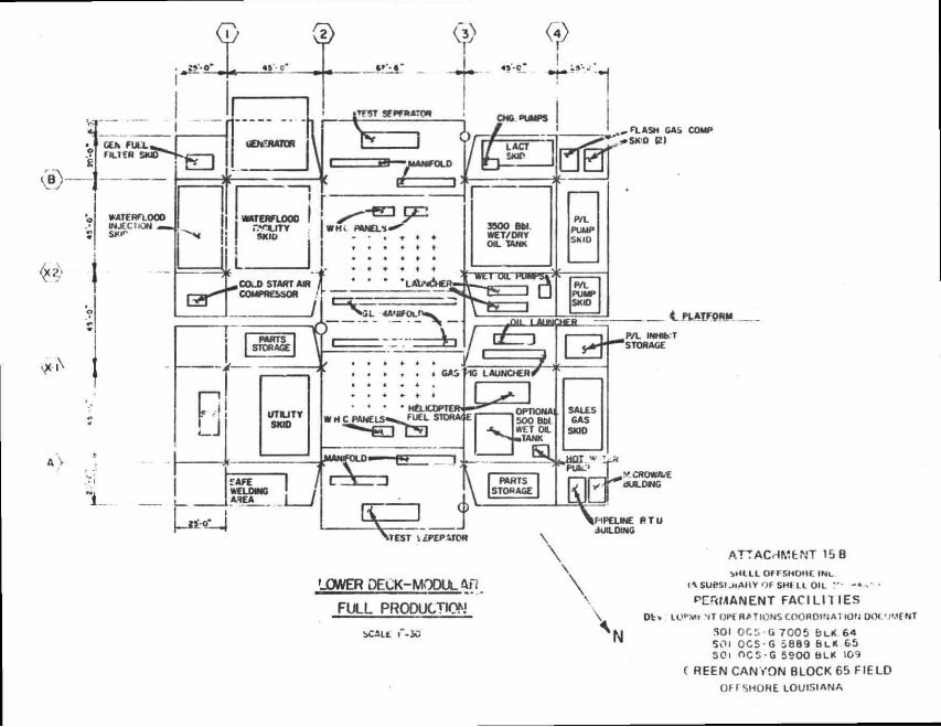
14 Comment*, Production - i c i l i t i e s 9
15 Diagram, Ptoduce-Vhile-Drllllng (PWD) F a c i l i t i e s 9
15a Diagram, Permanent F a c i l i t i e s Upper Deck 9
15b Diagram, Permanent F a c i l i t i e s Lower Deck 9
16 Map, Possible Pipeline Routes 9
17 Comments, S p i l l Prevention, Control and 9
Countermeasure Plan
18 Comments, Air Enissions Data 9
19 Description, Onshore Support F a c i l i t y • 9
20 Support Vessels, Description, Travel Frequency 9
21 Plat, Lease Vi c i n i t y and Transportation Routes 9
22 Certificate of Consistency, Louisiana 9
23 Map, Bathymetry and Navigation Post Plots 5*
24 Environmental Report 9
* Confidential
Attachment 1 (Cont'd)
LCf513404V

Y t 10 ,157,800 '
SOI
OCS-G 7005
64
Y • 10,121,760'
SOI OCS-G 5889
65 • T - I
5200 '—9 PLATFORM
" A*
« T - I
AGIP ETAL
OCS-G 7014 SOI
fr- t P OCS-G 5900 «T-I I
SOI
108 109
i Y i lO ,105 ,920 '
Q PROPOSED SURFACE LOCATIONS
ATTACHMENT 4
SMELL OFFSHORE INC IA SUBSIDIARY OF SHE LL OIL COMPANY)
PROPOSED SURPACE LOCATIONS DEVELOPMENT OPE RATIONS COORDINATION DOCUUENT
SO I OCS-G 7C05 5 »« 64 SOi CCS-G 5 6 8 9 5- _ * C5 SCi OCS-G 5 9 0 0 _K 109
GREEN CANYON BLOCK 65 FIELD
Of rSHORE LOUISIANA
0 4 0 0 0 ' OOOO' 1 I I

CULTURAL RESOURCES DEVELOPMENT OPERATIONS COORDINATION DOCUMENT
SOI OCS-C 7005, GREEN CANYON BLOCK 64 SOI OCS-G 5689, GREEN CANYON BLOCK 65 SOI OCS-G 5900, GREEN CANYON BLOCK 109
GREEN CANYON BLOCK 65 FIELD OFFSHORE LOUISIANA
A search for cultural resources prior to installation of the platform on this lease ls not required.
NTL 83-3 v i l l be observed in installing the platform and laying tha pipelines.
Attachment 9
LC6512404W

DRILLING RIG DEVELOPMENT OPERATIONS COORDINATION DOCUMENT
SOI OCS-G 7005, GREEN CANYON BLOCK 64 SOI OCS-G 5889, GREEN CANYON BLOCK 65 SOI OCS-G 5900, GREEN CANYON BLOCK 109
GREEN CANYON BLOCK 65 FIELD OFFSHORE LOUISIANA
The platform-type drilling rigs ve intend to use, l Rig 12 and Shall Rig 11, hava previously been approved for uae In 'ulf of Mexico and at tha preaant time ara being operated by SOI ln tha St "(balier Block 300 Field and Grand lale Block 33 Field, reapectively.
!.C8513'.04V
Attachment 11

PLATFORM DESIGN SUMMARY DEVELOPMENT OPERATIONS COORDINATION DOCUMENT
SOI OCS-G 7005, GREEN CANYON BLOCK 64 SOI OCS-G 5889, GREEN CANYON BLOCK T s
SOI OCS-G 5900. GREEN CANYON BLOCK 109 GREEN CANYON BLOCK 65 FIELD
OFFSHORE LOUISIANA
Proposad Platfora "A" is designed to support wells and drilling/producing opsrations, including tvo platform-type drilling rigs. Tha platfora w i l l ba aat approxiaately 2,900' N and 5,200' E of the southwest corner of Block 65 (x - 2,317,840; y - 10,124,660) and w i l l bit ln approxiaately 1,350' of water. Attached are schematics of the proposed structure.
Appropriate applicationa for platform approval purauant to the requirements of OCS Order No. 8 are being made.
LC851340O?
Attachment 12
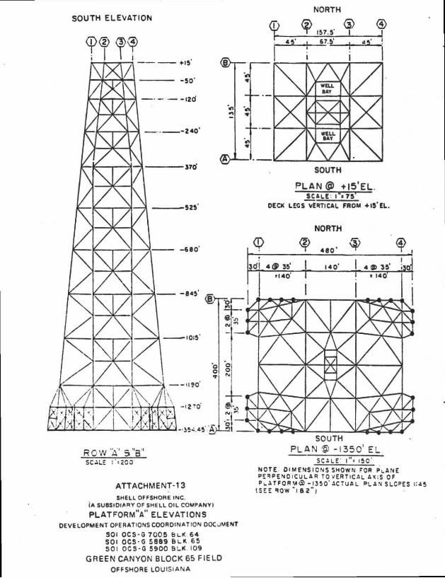
NORTH
SCALE f«2O0 SCALE l"» •SO" NOTE: DIMENSIONS SHOWN FOR PLANE PERPENDICULAR TO VERTICAL AX:S OF
ATTACHMENT-13 PLATFORM©-JSSO* ACTUAL PL AN SLOPES 1:45
SHELL OFFSHORE INC. (A SUBSIDIARY OF SHELL OIL COMPANY)
PLATFORMV ELEVATIONS DEVELOPMENT OPERATIONS COORDINATION OOCJMENT
SOI OCS-0 7 0 0 5 BuK 64 SOI OCS-G 5 8 8 9 B L K 65 501 OCS-G 5 9 0 0 BLK 109
GREEN CANYON BLOCK 65 FIELD
OPFSHORE LOUISIANA

EAST ELEVATION
R 0 W " l " & " 4 " ROW "2 " 6 "3 "
ATTACHMENT-13A SHELL OFFSHORE INC.
(A SUBSIDIARY OF SHELL OIL COMPANY)
PLATFORM'A" ELEVATIONS OEVELOPMENT OPERATIONS COORDINATION OOCUUENT
SOi OCS-G 7 0 0 5 BUC.64 SC. OCS-G 5689 bLK 65 SOi OCS-G 5900 BLK. 109
GREEN CANYON BLOCK 65 FIELD OFFSHORE LOUISIANA

COMMENTS. PRODUCTION FACILITIES DEVELOPMENT OPERATIONS COORDINATION DOCUMENT
SOI OCS-G 7005, GREEN CANYON BLOCK 64 SOI OCS-G 5889, GREEN CANYON BLOCK 65
SOI OCS-G 5900, GREEN CANYON BLOCK 109 GREEN CANYON BLOCK 65 FIELD
OFFSHORE LOUISIANA
PRODUCE-WHILE-DRILLING (PWD) FACILITIES
Production from captioned leases wil? i n i t i a l l y be conducted simultaneously with d r i l l i n g operstions on Platforn. "A". During th?s produce-while-drilling phase, production w i l l be transported multiphase via a 12" pipeline to Green Caryon Block 19, Platform "A" for separation, treating and sales. The equipment on GC 65 "A" w i l l provide for three-phase well test, an emergency vent system, f i r e - f i g h t i n g equipment and a close** platform drain system. Electric'power, instrument a i r for ESD systems, sonnel carters and emergency evacuation equipment w i l l he provided the d r i l x ng r i g .
PERMANENT FACILITIES
Subsequent to the removal of the d r i l l i n g r i g s , permanent production f a c i l i t i e s wi?l be installed. The proposed equipment w i l l provide for primary separation, well test, water treating and disposal, gas dehydration and sales and o i l dehydration and sales. Pletform u t i l i t i e s consisting of el e c t r i c power generation, f i r e - f i j h t l n g system, personnel quartering, and •.m'»rgency evacuation equipment are also planned for th i s complex.
This production equipment w i l l be designed and installed to conform with a l l applicable regulations. Detailed applications w i l l be submitted to the D i s t r i c t Supervisor at a future date.
Attachment 14
LC8513404W

<«*•
ATTACHMENT -15 . e t -F .1 OFFSHORE IMC.
<* i ^ l P . ^ ' . Y OF SHELL OIL COMPAfcY)
PRODUCED W H I L E D H I u M N G { P W D ) F A C I L I T I E S
LeVELOPMENT OPERATIONS COORDINATION DOCUMENT SO< OCS-6 7 0 0 5 BLK .64 SOI OCS-G 5689 6c.*. .65 SOI OCS-O 5 9 0 0 BLK. 109
GREEN CANYON BLOCK 65 FIELD OFFSHORE LOUISIANA

®
<T> (2>
/ p-* 1
/ (
\ s
\
BEAM PACKAGE
j PLATFORM
ATTACHMENT 15A SHELl OFFSHORE INC
(A SUBSIDIARY Of SMELL OIL COMPANY!
PERMANENT FACIUTIES UEVELOPMENT OPERATION!. COORDINATION DOCUMFNT
SOI OCS-G 7 0 0 5 6L< 64 SOi OCS G 5889 B L K 6b 501 OCS-G 5 9 0 0 BLK 109
G R E F N C A N Y O N BLOCK 65 F I F L D OFFSHORE LOUISIANA
, a ASM GAS COMP - S K O (2)
ATTACHMENT 15 B V i l l i Of FSHOHI INc
lASUBSIJ lA i lY OF S H U L OIL - * . '
P E R M A N E N T F A C I L I T I E S D t v LO«'Mi NT OPf RATIONS COORDINATION DOC'lMf NT
SOI OCS-G 7 0 0 5 B L K 64 SOi OCS - G 5889 BLK 65 SOi OCS-G 5 9 0 0 BLK »09
C REEN C A N V O N BLOCK 65 F I E L D
OF f SHORE LOUISIANA
SMELL OF FSH )RE INC (A SUBSIDIARY OF SHEL' OH COMPAN •
POSSSJLE PIPELINE ROUTES OEVELOPMENT Of t RATIONS COORDINATION Out • - « * • !
SOI OCS-G 7 0 0 5 * : L K 6 4 SOI OCS G 5 6 8 9 BLK 65 SOI OCS-G 5 9 0 0 BLK. 109
GREEN CANYON BLOCK 65 HELO
OFFSHORE LOUISIANA
MILES
SPILL PREVENTION, CONTROL ANP COUNTERMEASURE PLAN
DEVELOPMENT OPERATIONS COORDINATION DOCUMENT SOI Ors-G~70J5, GREEN CANYON BLOCK 64 SOI OCS-G 5889, GREEN CANYON BLOCK 65
SO». OCS-G 5900, GREEN CANYON BLOCK l"u9 GREEN CANYON BLOCK 65 FIELD
OFFSHORE LOUISIANA
SOI's Intest revisions to i t s "Sr i I I Prevention, Control nnd Countermeasure Plan" were Approved by the MMS c . November 27, 1984. The development d r i l l i n g plans proposed for. -'th w i l l rely primarily on the s p i l l equipment sto ed at the Clean Gult Ar; cc fates bases 'in Grand Isle and Venice, Louisiana. Section I I I of the submitted pl.ma lists available equipment at these base* plus other banes from which additional equipment can he drawn. Section I I l i s t s the preventive measure* to be taken to minimize o i l spills and the reporting procedures to be followed in the event that one occurs. Section VI provldea a detailed discussion of the clean-up procedurea to be Initiated, including a listing of the personnel that make up the clesn-up organisation. The training of these personnel is summarized in Section XII. Assumi two hoors to load out equipment and a 12-knot cruising speed, a fast res awt unit can normally be on l o c •'ion in ten tours.
1• 851340.'.V Att?»:hmeni 17
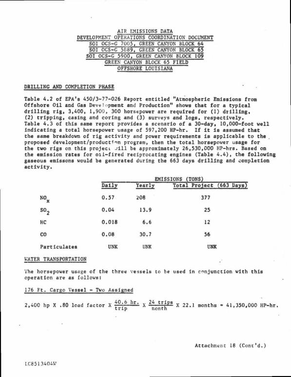
AIR EMISSIONS DATA DEVELOPMENT OPERATIONS COORDINATION DOCUMENT
SOI OCS-G 7003, GREEN CANYON BLOCK 64 SOI OCS-G 5169, GREEN CANYON BLOCK 65 SOI OCS-G 5900. GREEN CANYON BLOCK 109
GREEN CANYON BLOCK 65 FIELD OFFSHORE LOUISIANA
DRILLING AND COMPLETION PHASE
Tabla 4.2 of EPA's 450/3-77-026 Report ent i t l e d "Atmospheric Emissions fron Offahore Oil and Gaa Developnent and Production" shows that for a typical d r i l l i n g r i g , 3,400, 1,900, 300 horsepower are required for (1) d r i l l i n g , (2) t r i p p i n g , caaing and coring and (3) surveys and logs, respectively. Table 4.3 of this same report provides a scenario of a 30-day* 10,000-foot well indicating a t o t a l horsepower usage of 597,200 HP-hr. Zf i t l a assumed that the sana breakdown of r i g a c t i v i t y and power requirenenta l s applicable to tha . propoaed development/product *nr\ program, then the t o t a l horsepower uaage for thc tvo rigs on this project . / i l l be approxinately 26,530,000 HP-hrs. Based on the emission rates for o i l - f i r e d reciprocating engines (Table 4.4), tha fo l l o v i n g gaseous enissons would be generated during the 663 daya d r i l l i n g and completion a c t i v i t y .
EMISSIONS (TONS) Daily Yearly Total Project
N O x 0.57 208 377
so2 0.04 13.9 25
HC 0.018 6.6 12
CO 0.08 30.7 56
Particulatea UNK UNK UNK
WATER TRANSPORTATION
The horsepower usage of the three vessels to be used in conjunction with t h i s operation are as follows:
176 Ft. Cargo Vessel - Two Assigned
2,400 hp X .80 load factor X t ° \ b h r ' * 2 4 X 22.1 months - 41,350,000 HP-hr. t r i p month
Attachment 18 (Cont'd.)
LC8513404W

2
80 Ft. Standby Vessel
165 hp X .80 load factor X 2 3 £ ™ ' X 663 days - 2,010,000 HP-hr.
1,000 hp X .80 load factor X I j j ^ X 663 days - 530,000 HP-hr.
TOTAL 43,890,000 HP-hr.
Based on Tabla 4.4, the gaaeoua emissions generated by vater tranaportation are aa follows:
EMISSIONS (TONS) Dally Yearly Total Project
KOx 0.94 344 624
BOg 0.06 23 42
HC 0.03 11.6 21
CO 0.14 50 91
Particulates UNK UNK UNK
PRODUCTION PHASE
Thc following alr-emiaslon sources v i l l operate during the production phaae:
Tvo gas compressors v/4,000 HP IC engine. Three generators w/1100 HP turbine-driven engine drive (including spare on standby).
Based on Table 4.4 and assuming 95Z service factors and gas firing, the gaaeoua emissions generated by theae sources are aa follows:
TOTAL EMISSIONS (TONS) Daily Yearly
NOx 2.98 1,087
S0 2 0.016 5.7
HC 1.26 460-
CO 0.73 266
Particulates UNK UNK
Attachment 18 (Cont'd.)
LC85I1404W

3
EXEMPTION CALCULATION FOR DRILLING, COMPLETION, AND PRODUCTION ACTIVITIES
Tht proposed location Is 81 miles from the nearest shoreline. Therefore, the emission exemption (E) fo r the various pollutants Is as f o l l o v s :
CO E • 3,400 ( 8 1 ) 2 / 3 - 63,650 tons/year
W ) X )
SO, ) E - 33.3 (81) - 2,7000 tons/year 2 )
HC )
Particulates
Maximum yearly emissions from thc d r i l l i n g and completion, or production operations are:
Tons/Year
NOx 1,087 (production phase)
S02 37 ( d r i l l i n g and completion phase)
KC 460 (production phase)
CO 266 (production phase)
Particulates UNK
The t o t a l emission for any one pollutant does not exceed the exemption tota l s 'above; consequently, no further a i r quality reviev i s required for emissions from Green Canyon Block 65.
LCP513i04W
Attachment 18 (Cont'd.)

ONSHORE SUPPORT FACILITY DEVEOPMENT OPERATIONS COORDINATION DOCUMENT
SOI OCS-C 7005, GREEN CANYON BLOCK 64 SOI OCS-C 3889. GREEN CANYON BLOCK 65 SOI OCS-G 5900, GREEN CANYON BLOCK 109
GREEN CANYON BLOCK 65 FIELD OFFSHORE LOUISINA
Tht onshore support bast for this activity will bt SOI*a axlating Venice Terminal. Thia facility la located on the Mississippi River near Venice, Louisiana, approximately 35 miles up-river from the Gulf of Mexico. Tha physical plant covera 14 acres and Includes 1,000 linear faet of waterfront, 3,000 aquart feet of office apace, 3,200 square feet of personnel quartering apace and 7,200 aquare feet of covered warehouae area. One 45-ton crane and two fork trucks are uaed for material handling operationa. No expanalon of the Venice Ternlmal will be required for thia activity. In addition to tha above, tubular goods will usually be shipped by land to Venice from one of the contract warehouses located In Morgan City, Louisiana, which will alao require no expanalon*. Alao, while pereonnel transported by helicopter will be picked up and returned to SOI'a Venice Terminal, both Air Logistics snd PHI operate baees at Venice for refueling and maintenance.
t
LC8513404W
Attachment 19

SUPPORT VESSELS DEVELOPMENT OPERATIONS COORDINATION DOCUMENT
SOI OCS-G 7005, GREEN CANYON BLOCK 64 SOI OCS-G 5889, GREEN CANYON BLOCK 65 SOI OCS-G 5900. GREEN CANYON BLOCK 109
GREEN CANYON BLOCK 65 FIELD OFFSHORE LOUISIANA
ITEM
Boat
Boat
Halicopter
SIZE OR MODEL USE
176'1 Cargo
SO'-lOO' Standby
Bell 205, 206B or 212 Crew Change and Misc.
TRIPS PER WEEK
5 or 6
N.A.
30 to 34
NOTE: Boat and helicopter schedules reflect requirenents for 2 platform-type drilling riga.
LC85134C4W
Attachment 20

.... ATTACHMENT 21 OOSE-. SHELL OFFSHORE INC.
(A SUBSIDIARY OF SHELL OIL COMPANY! .. .. . L E A S E V 1 C | N | T Y 5, TRANSPORTATION ROUTES
DEVELOPMENT OPERATIONS COORDINATION DOCUMENT - - SOI OCS-G 7005 BLK 64
SOI OCS-G5899 BLK.65 S O I O C S - G 5 9 0 0 BLK.109
• - GREEN CANYON BLOCK 65 FIELD • - • • — - - ' OFFSHORE LOUISIANA
• • • 0 6 12 18 24 l — J I I I
MILES

COASTAL ZONE MANAGEMENT CONSISTENCY CERTIFICATION
DEVELOPMENT OPERATIONS COORDINATION DOCUMENT Type of Plan
GREEN CANYON BLOCK 64 GREEN CANYON BLOCK 65 GREEN CANYON BLOCK 109
Areas and Blocks
SOI OCS-G 7005 SOI OCS-G 5689 SOI OCS-G 5900 Lease Numbers
....vices described In detail in this Plan comply with Louisiana's appvoved Coastal Management Program and w i l l be conducted in a manner consistent with such Program.
Such findings sre summarized on the final page of the attached Environmental Report (Eii).
SHELL OFFSHORE INC. (SOI) Operator
- 7 ^ T. K. Corcoran, Division Manager Safety and Environmental Conservation
77 Date
LC8513404W
Attachment 22

CSA (1) TITLE PAGE
CwuWnlaf Sfii{| Aceoafe. Inc. P. O. Box 3609 Jupiter/Tequesta, Florida 33458
ENVIRONMENTAI- REPORT (DEVELOPMENT OPERATIONS COORDINATION DOCUMENT)
GULP OP MEXICO: OFPSHORE LOUISIANA GREEN CANYON AREA
BLOCK 64 (OCS-G 7005) BLOCK 65 (OCS-G 5889) BLOCK 109 (OCS-G 5900) PLATPORM "A" (BLOCK 65) SHELL OFPSHORE INC.
28 MAY 1985
wits AMO ntcutenoi
Mr. T . M. Randolph Sanior S t a f f Environmental Engineer
S h e l l Offshore I n c . One S h e l l Square
P.O. Box 60159 New Orleans , Louis iana 7G160
Telephone: (504) 588-6468
'Applied Science and Technology"
i i
TABLE OF CONTENTS
( 1) TITLE PAGE
LIST OF FIGURES
(2) DESCRIPTION UF THE PROPOSED ACTION
(a) Description of Proposed Travel Modes and Routes and Frequency f o r Moving Supplies and Personnel t o and f r o a the Offshore A c t i v i t y s i t e and the Onshore Rases
(b) I d e n t i f i c a t i o n of Support Bases and Nuaber .uid Types of *** •* Workers Associated t i l t h the Proposed A c t i v i t i e s . Ref - i < a Is Also Made t o the Most Current Update of the Socioe. vr >i?.ic Data Baaa Raport
( c j I d e n t i f i c a t i o n of t • 1.*.~J*X, Location, and Size of Any N* »• Support F a c i l i t i e s at V i l l Meed To Be Provided f o r the Proposed A c t i v i * • Uvi
(d) Description of Anv »<w Techniques or Unusual Technology TIM. May Affect Cr>4«tal Waters
(a) Maps Sho. ing Location of the Proposed A c t i v i t i e s l n Relation t o Each of the Affected States' TosL-tal Zones
( f ) For Developaent Operations Coordination Documents, the Maans Proposed t o Transport O i l and Gas .o Shere from the Lease Area and the Routes To Be Followed aid '.he Estimated Quantities of O i l and Gas To Be Moved along Such Routes
(3) DESCRIPTION OF THE AFFECTED ENVIRONMENT AND IMPACTS
(a) Physical and Environmental
( i , Commercial Fiahing
( i i ) Shipping
( i i i ) Small C r a f t Pleasure Boating, Sport r i s h i n g , and Recreation
( i v ) C u l t u r a l Resources
(v) E c o l o g i c a l l y Sensitive Features
( v i ) E x i s t i ' .} Pipelines and Ca'jles
PAGE
i
i v
1
1
( v i i ) o t i w i Minera l Uses 12

i i i
TABLE OF CONTENTS (CONTINUED)
<i
PAGE
( v i i i ) Ocean Dumping A c t i v i t i a a
( i x ) Endangered or Threatened Species 13
rb ) Socioeconomic 14
(4 ) UNAVOIDABLE ADVERSE IMPACTS 15
(a ) Summary of the Unavoidable Adver"-*> Impacts 15
(b ) Statement Concerni ng the Unavc i oab lo Adverse Impacts 15
(5 ) REFERENCES 17
( 6 ) i T.NAL STATEMENT 19

LIST OP FIGURES
FIGURE DESCRIPTION
1 LOCATION OF GREEN CANYON AREA BLOCKS 64, 65, AND 109 RELATIVE TO THE LOUISIANA COASTAL ZONE (ADAPTED FROM: USDOI, MMS, 1984).

1
(2) DESCRIPTION OF THE PROPOSED ACTION
(*) Deacrlptton of Proposed Travel Modes and Rou-aa and Frequency for Moving Supplies and Personnel to and from t l offshore A c t i v i t y Sita and the Onshore Bases
Shell Offshore Inc. plans to conduct development/production
a c t i v i t i e s i n Graan Canyon Area Blocks 64, 65, and 109. Helicopters and
boats w i l l move supplies and personnel to and from the offshore and
onshore locations. Helicopters w i l l make approximately 30 to 34 round
t r i p s per week, and boats w i l l make approximately 24 round t r i p s par
month* I f servicing only the proposed leasa area, helicopters and boats
w i l l normally take tha most direct route, weather and t r a f f i c conditions
permitting (see Figure 1).
(b) Identification of Support Bases and Number and Types of New Workers Associated with tha Proposed A. t i v i t i e s . Reference i s Aiso Made to the Most Currant Update of the Socioeconomic Data Basa Report
Thu support bade w i l l be located in Venice, Louisiana. The base is
capable of providing the services necessary tor the proposed a c t i v i t i e a .
No new f a c i l i t i e s or workers w i l l be needed for the proposed a c t i v i t i e a .
The i n i t i a l OCS Socioeconomic Data Base Report w i l l be developed after
the MMS and the States of Alabama, Louisiana, and Mississippi have
ide n t i f i e d the specific parameters to be addressed in these semiannual
reports.
(c) Identification of the Nuinber, Location, and Size of Any New Support F a c i l i t i e s That Wi l l Need to be Provided for the Proposed Act i v i t i e s
No new support f a c i l i t i e s w i l l be needed for the propose.-,
a c t i v i t i e s .

• K i l l 1 • 1 f f f f f l H W
FIGURE 1. LOCATION OF GREEN CANYON AREA BLOCKS 64. 65. ANO IOB RELATIVE TO THE LOUISIANA COASTAL ZONE (ADAPTED FROM: USDOI. MMS. 1084).
3
(d) Description of Any New Techniques or Unusual Technoloqy That May Affect Coastal Waters
No new techniques or unusual technology w i l l be used during the
proposed a c t i v i t i e s .
(•) Maps Showinq Location of the Proposed A c t i v i t i e s ln Relation to Bach of the Affected States' Coastal Zonea
Figure 1 shows the location of the proposed a c t i v i t i e s in relation
to each of the affected States' coastal zones. The proposed a c t i v i t i e s
w i l l take place in waters adjacent to tne State of Louisiana.
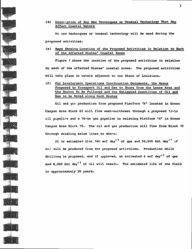
(£) For Development Operations Coordination Documents, the Means Proppsed to Transport Oil and Gas to Shore from the Lease Area and the Routes To Be Followed and the Estimated Quantities of Oil and Gas to be Moved along Such Routes
O i l and gas production from proposed Platform "A" located i n Green
Canyon Area Block 65 w i l l flow west-northwest through a proposed 12-in
o i l pipelire and a 16-in gas pipeline to existing Platform "A" i n Green
Canyon Area Blork 19. The o i l and gas production w i l l flow from Block 19
through existing sales lines to shore.
I t is estimated that 100 mcf day - 1 of gaa and 50,000 bbl day"1 of
o i l w i l l be produced from the proposed a c t i v i t i e a . Production while
d r i l l i n g is proposed, and i f approved, an estimated 4 mcf day"1 of gas
and 8,000 bbl day"1 of o i l w i l l reeult. The estimated l i f e of the f i e l d
i s approximately 20 years.

4
(3) DESCRIPTION OF THE AFFECTED ENVIRONMENT AMD IMPACTS
(a) Phys ica l and Environmental
( i ) Commercial F i s h i n g
The proposed a c t i v i t i e s are located j u s t south of some of the
most p roduc t ive f i s h i n g grounds i n the Gul f o f Mexico* Na t iona l Marine
F i s h e r i e s Service Zone 14, loca ted 9 km (5 NM) south of the lease area,
accounted f o r approximately 7% of the commercial f i s h e r i e s harvest f r o m
the western and c e n t r a l Gu l f of Mexico (USDOI, BLM, 1981, V i sua l No. 5;
USDOI, MMS, 1984, V i s u a l No. 4 - 1 ) . Gulf waters account f o r app rox iaa t e ly
30% o f the t o t a l annual U.S . f i s h e r i e s harvest (USDC, 1982).
The Gulf f i s h e r y i s dominated by the s h e l l f i s h f i s h e r i e s . Shrimps,
c r a b s , and oysters ( w i t h smaller amounts of clams and sca l lops) are the
most va luab le f i s h e r i e s and are usua l ly wor th three or fou r times more
than the greater volume of f i n f i s h catch (USDOI, BLM, 1979). The UCDC
(1982) l i s t ' s the annual commercial f i s h e r i e s landings s t a t i s t i c s f o r the
n o r t h e r n Guif coast area onshore from the lease area.
rhe *nrimc f i s h e r y i n the G^Xf of Mexic- Includes the brown (Penaeus
a z t e c u s ) , white (P. s e t i t a r u s ) , and pink (P. duorarum) shrimps. These
species arc taken almost e x c l u s i v e l y by t r a w l s i n depths ranging f r o n
approximate ly 2 t o 73 m (6 t o ;40 f t ) . These shrimps are
estuarine-dependent species which spawn i n the open ocean, go through a
s e r i e s of l a r v a l phases i n the p lankton, migra te dur ing the p o s t - l a r v a l
phase t o the estuarine nursery areas, and then r e t u m to the open Gul f as
a d u l t s . The USDOI, BLM (1977, V i sua l No. 5) ind ica tes the seasonal
v a r i a t i o n i n the habi t s of each of these species . The lease area i s

5
located outside the major shrimp spawning grounds and migration routes in
the northern Gulf (USDOI, MMS, 1984, Visual No. 4-1). Planktonic eggs
and l a rva l stages of a l l commercially important shrinp species may occur
pe r iod ica l ly in the leasa araa.
The blue crab (Callinectes sapidus) makes up 98% of the crab harvest
i n tha Gulf of Mexico (Riley, 1970). I t s l i f e cycle is similar to the
shrimps' i n that i t haa planktonic, estuarine, and cpen ocean phases.
Adults .pend most of tha i r l ives in the estuaries; th-j" ru*. blue crab
harvest is taken inshore of the lease area. Gravid females migrate to
the open Gulf to release thei r eggs during spring and summer.
Consequently, gravid females and planktonic larvae may occur seasonally
i n the lease area.
The proposed a c t i v i t i e s are located outside commercially important
f i n f i s h f i sh ing grounds (USDOI, MMS, 1984, Visual No. 4-1). Three
species of menhaden known from the Gulf make up the major f i n f i s h tonnage
taken. These are Brevoortia patronus, B. gunteri , and B. amithi .
Brevoortia patronus comprises most of the Gulf catch. Purse seining is
the major capture method used in this fishery (Lindal l et a l . , 1972).
Red snapper (Lutjanus campechanus) and various species of grouper
( i . e . , the red grouper Epinephelus morio and gag Mycteroperca microlepis)
compose the commercial hook-and-line fishery of the northern Gulf of
Mexico. These fishes may be taken over irregular bottom areas in depths
of 2 to 305 tn (5 to 1,000 f t ) (TerEco Corporation, 1976).
The striped mullet (Mugil cephalus) is generally found in nearshore
areas such as harbors, estuaries, bays, and along beaches. I t is a
schooling f i sh and is generally taken with seines and trawls.

6
The Atlantic croaker (Micropogonias undulatus) is au abundant fis'.i
i n estuarine waters. Perret •*'£ a l . (1971) reported croaker to bo the
most abundant juvenile commercial fi s h taken in estuaries. Croaker i s
harvested and marketed both as a food fish and as an industrial bottom
f i s h (Lindall et a l . , 1V72).
The Florida pompano (TrachinotU3 carolinus) i s primarily an inshore
f i s h that is taken mostly i n the surf or at passes. I t i s seasonally
abundant (January to Ap r i l ) in shrimping areas.
The Spanish mackerel (Scomberomorus maculatu3) migrates seasonally
along the Gulf coast. I t i s generally taken in nearshore areas.
The red drum (Sciaenops ocellatus) is taken predominantly i n
nearshore habitats, as are the sheepshead (Archosargus probatocephalus),
flounders, and the black drum (Pogonias cromis).
Seatrouts, including the spotted (Cynoscion nebulosus), the silver
(C. nothus), and the sand (C. arenarius), are important to the bottom
f i a h fisheries in the northern Gulf (Lindall et a l . , 1972). They are
usually taken in offshore areas with bottom trawls.
TerEco Corporation (1976) describes some additional f i s h species of
the northern Gulf which are important to commercial and/or sport
fishermen and their predominant method of capture. Most of the northern
Gulf fishes are temperate, with some incursions from Caribbean fauna.
They exhibit seasonal distribution and abundance fluctuations related to
oceanographic conditions (USDOI, MMS, 1984, p. 63). Many of the coastal
species (e.g., the croaker, Micropogonias undulatus) are
estuarine-dependent, because estuaries or coastal marshes are a c r i t i c a l
habitat during sorae phase of their l i f e cycles. Rogers (1977) postulated

7
a net inshore-offshore movement for many demersal shelf f i s h species.
Thus, i t is probable that many of these species may occur in the leaf a
area at some phase of their l i f e cycles.
Eggs and larvae (ichthyoplankton) of variou8 commercially important
f i s h species are probably also present in the lease area on occasion.
Sixty-nine f i s h species have been id e n t i f i e d from zooplankton samples
taken along the northern Gulf coast. Dominant taxa ware the families
Sparidae. Lutjanidae, Triglidae, Serranidae, and Synodonti
Stenotomus caprlnus, Prlstipomoides aguilonaris, Prionotus pai j i a t u a ,
Serranus atrobranchus, and Synodus foetens were the most important
species (Chittenden and Moore, 1976). Since the majority of
i.-hthyoplankters are at the mercy of water movements, their distributions
vary considerably with space and time. The primary factors influencing
ichthyjpi»»nkton in the northern Gulf are the Loop Current, the
Mississippi River, and local runoff. Due to "patchiness" i n
distributions, presence and abundance of ichthyoplankton at any given
instance cannot be prodicted.
The proposed a c t i v i t i e s probably w i l l temporarily degrade the water
quality in the immediate v i c i n i t y of the d r i l l s i t e due to discharges of
d r i l l i n g fluids and cuttings. Thi* may cause certain f i s h species to
avoid the area. Commercial fishing may be affected temporarily. The
situation should revert to normal as soon «JS d r i l l i n g is completed.
Cumulative effects of increasing o i l and gas a c t i v i t i e a off the northern
Gulf coast on annual catches are as yet unknown. However, there are no
data to indicate that o i l and gas a c t i v i t i e s are responsible for any
decline in annual catches (USDOI, BLM, 1979, p. 181).

8
Any o i l s p i l l that would impact the seafloor could conceivably k i l l
benthic organisms such as shrimps or cause a variety of sublethal
effects. The potential long-term effects of a s p i l l on the benthos are
unclear because results of hydrocarbon analyses are inconclusive (USDOI,
BLM, 1979, p. 160).
An o i l s p i l l would temporarily degrade water quality and introduce
toxins into the water. Ichthyoplankton, i f present, may be k i l l e d or
functionally impaired. However, most adult fishes encountering a s p i l l
and associate toxic water would probably exhibit avoidance behavior.
This effec. would be temporary and fishes should return to the area after
dispersal of the s p i l l . No si.;r< .ficant or persistent direct effects from
an o i l s p i l l on f i s h populations would be expected. Recruitment from
surrounding areas should quickly replenish any affected ichthyoplankton
populations once the s p i l l has dispersed. Any s p i l l would be handled
according to an o i l s p i l l contingency plan approved by the MMS.
( i i ) Shipping
The proposed a c t i v i t i e s are located approximately 3 kra (1.7 NM)
south of a i t ' <*ay (USDOI, MMS, 1984, Visual No. 11). The proposed
a c t i v i t i e s are rated as having maximum potential impact on shipping as
they are less than 5 km (2.6 NM) fr->m a f »irway (USLOI, BLM, 1979,
p. 145). The offshore structure w i l l be equipped with a l l safety
equipment required by the 'J.S. Coast Guard and the MMS to al e r t ships of
i t s presence in a l l weather conditions.
( i i i ) Small Craft Pleasure Boating, Sport Fishinc,, and Recreation
Ditton and Graefe (1978) determined that o i l and gas structures
are the most popular offshore recreation destination areas, attracting

9
87% of the boats t h a t f i s h e d offshore i n t h e i r study area. C e r t a i n
pleasure boats ( i . e . , s a i l b o a t s , pleasure yachts, an-Vor open ocean
racing power boats) may be s l i g h t l y inconvenienced by having to maneuver
around the offshore s t r u c t u r e and i t s support vessels. This
inconvenience i s considered extremely minor as offshore s t r u c t u r e s can be
avoided and ample maneuvering room i s a v a i l a b l e .
Any sports f i s h i n g which might occur i n the lease area could be
temporarily a f f e c t e d by degradation of water q u a l i t y during d r i l l i n g .
Such a change i n water q u a l i t y could cause some desirable species t o
avoid the immediate lease area. However, any such e f f e c t s are expected
t o be temporary and l u c a l i z e d and should not a f f e c t any f i s h e r y p o t e n t i a l
i n tl.a area as a whole. Populations should r e t u r n t o normal once
d r i l l i n g i s completed.
( i v ) C u l t u r a l Resources
Coastal Environments, Inc. (1977) has i d e n t i f i e d two types of
c u l t u r a l resources which may be found i n the northern Gulf of Mexico
area: (1) h i s t o r i c c u l t u r a l resources or shipwrecks and (2) p r e h i s t o r i c
c u l t u r a l resources or traces of previously undesctxbed human
c i v i l i z a t i o n s (USDOI, MMS, 1983, pp 228-240). Approximately 82% of the
known shipwrecks are located w i t h i n 10 km (5 NM) ..r shore, w i t h only a
small percentage o c c u r r i n g on t h * "-"S (Ut-V>I. 3LM, 1979, p • 91). Known
submarine archeological s i t e s are e>vrenw*ly rare, t h none being
i d e n t i f i e d to date i n Federal offshore leas.ng areas (USDOI, BLM, 1979,
p. 91).
The proposed a c t i v i t i e s are located outside the H i s t o r i c and
P r e h i s t o r i c C u l t u r a l Resources High P r o b a b i l i t y Lines (USDOI, MMS, 1984,

10
Visual No. 11) and therefore are in a large offshore araa where histor i c
and prehistoric resources are considered unlikely to ba found. An
Archeological Survey was not required for this leasa area,
(v) Ecologically Sensitive Features
Several areas of environmental concern are located onshore of
the lease area. The Louisiana Coastal Zone Management Program has been
developed by the State to regulate the significant land and water
a c t i v i t i e s between the outer l i m i t of the coastal waters and land up to
the Intracoastal Waterway and/or the 10-ft contour. Land uses which are
regulated are those that have a direct and significant inpact on the
coastal area requiring a State permit, and those which are required by
Federal law to be consistent with the management program (USOC and LDNR,
1980). The program provides for the protection ot beaches, dunes,
wetlands, submerged grass beds, barrier islanda, oyster reefa, cultural
resources, water quality, air quality, biological resources, and w i l d l i f e
habitat. Unique ecological features include zoological, botanical, and
geological formations characteristic of coastal processes (Burk and
Associates, Inc., 1975; USDC and LDNR, 1980). Biologically sensitive
area of the north-central Gulf area include estuarine and coastal
ecosystems comprised of salt marshes, oyster beds, grass beds, barrier
beaches, and dunes (Coastal Environments, Inc., 1980). These coaatal
ecosystems contain nursery areas for many species of economic importance
aa well as habitat, rookeries, major overwintering sites, and nesting
areas for many endangered and threatened species, such as the southern
bald eagle, brown pelican, golden eagle, osprey, red cockaded woodpecker.
11
Aner ican peregrine f a l c o n , and various marine t u r t l e s (USDOI, BLM, 1979,
V i s u a l No. 3; Coastal Environments, I n c . , 1980; USDC and LDNR, 1980).
There ere two e x i s t i n g "Special Management Areas" designated by tha
Lou i s i ana Coastal Management Program (USDC and LDNR, 1980, pp. 104-108).
These areas are the "Louioiana Offshore O i l Po r t " (LOOP or Superport) and
the "Marsh I s land W i l d l i f e Refuge and Game Preserve." The lease area i s
l o c a t e d 189 km (102 NM) south-southeast of Marsh I s l and W i l d l i f e Refuge
and Game Preserve and 132 km (71 NM) southwest of the LOOP. None of the
proposed a c t i v i t i e s i n t h i s lease area should have any e f f e c t upon the
S p e c i a l Management Arses .
Conspicuous areas of environmental concern f o r Louisiana ara
d e p i c t e d by the USDOI, BLM (1979, V i s u a l Nos. 1 and 4) and tha USDC and
LDNR ( 1980, Pigure No. D - 1 ) .
The coastal zone area i s also of r e c r e a t i o n a l importance t o
r e s i d e n t s and t o u r i s t s . Most r e c r ea t i ona l a c t i v i t i e s focus on the area 's
water resources which inc lude beaches, boa t ing areas, and f i s h i n g areas.
The on ly o f f sho re areas o f designated b i o l o g i c a l s i g n i f i c a n c e are Diaphus
Bank, located 23 km (12 NM} northeast of the lease are... and Ewing Bank,
l o c a t e d 18 km (10 NM) nor th-nor thwest of the lease area. The proposed
a c t i v i t i e s should have no e f f e c t on these p ro tec ted areas of b i o l o g i c a l
s i g n i f i c a n c e or on remnant coasta l banks, or oyster grounds.
While o i l s p i l l s du r ing d r i l l i n g operat ions are rare (Danenberger,
1 6 ) , the p o s s i b i l i t y of a s p i l l does e x i s t . O i l f o u l i n g i n any coas ta l
area cou ld d i r e c t l y or i n d i r e c t l y a f f e c t a v a r i e t y of species, i n c l u d i n g
threa tened or endangered species or species important to commercial and
s p o r t f i s h e r i e s . Di rec t e f f e c t s on b io ta would Include f o u l i n g

12
( p a r t i c u l a r l y b i r d s ) , s u f f o c a t i o n ( p a r t i c u l a r l y f i shes and t u r t l e s ) , and
t o x i c i t y f rom contact or from the inges t ion of o i l or contaminated f o o d .
Any o f these e f f e c t a could be l e t h a l , cause weakening, or cause a greater
s u s c e p t i b i l i t y to p r e d a t i o n . S i g n i f i c a n t eco log ica l or economic impacts
cou ld also r e s u l t f rom the f o u l i n g of oys ter beds and h a b i t a t s . I n d i r e c t
e f f e c t s would inc lude the de s t ruc t i on of c r i t i c a l h i b i t a c a , e s p e c i a l l y
breeding and nursery areas. Any e f f e c t a on endangered or threatened
species would be s i g n i f i c a n t .
O i l f o u l i n g of the coas ta l area could also have adverse
socioeconomic e f f e c t s . Tourism i s an important par t o f Gulf coast
economies. Ramoval o f beach or other coas ta l areas from r e c r e a t i o n a l use
by o i l f o u i i n g would s i g n i f i c a n t l y decrease tour ism i n the a f f e c t e d area
and cause loss of income and a v a r i e t y of r i p p l e e f f e c t s i n l o c a l
economies.
Any s p i l l would be handled according to an o i l s p i l l contingency
p l a n approved by the MMS. I f a ppi 11 d i d occur dur ing opera t ione , l t i e
u n l i k e l y t ha t i t would a f f e c t any nearshore or onshore >reas or
reaourcea.
( v i } E x i s t i n g P i p e l i n e s and Cables
There are no e x i s t i n g p ipe l i ne s or cables i n the lease area
(USDOI, MMS, 1985).
( v i i ) Other Minera l Uses
Other than p o t e n t i a l o i l and gas reserves, there are no known
m i n e r a l resources i n the lease area.
13
( v i i i ) Ocean Dumpinq Activitiea
The propoaed activities are not located ln an area designated
for ocean dumping act iv i t ies .
(ix) Endangered or Threatened Speciea
The USDOI, BLM (1979, p. 45) considers possible impacts of
lease activities on endangered species in this area of the Gulf to be
temporary, localised, and chance occurrences. I t haa judged the
potential impacts on endangered species to be remote pe*i~ b< t**»
without major potential for direct effeccs on any single *>CA Xn
addition, i t has been determined that lease aot » no .asult in
tha destruction or modification of doc.7nace>l c r i t i c At-*ts or
potential cr i t i ca l habitats. Onshore fac i l i t i es are located in a
previously developed area and pose no nw» cr t d."lt<onivL threat to
endangered or threatened species.
Approximately six endangered speciee ot cetaceans occur in the Gulf
of Mexico. They are the blue whale (Balaenoptera musculus), f in whale
(Balaenoptera physalus), humpback whale (Megaptera novaeangliae), right
whale (Eubalaena g lac ia l i s ) , sei whale (Balaenoptera borealls), and sperm
whale (Physeter catodon). Generally, most of these larger cetaceans
occur in continental shelf, slope, or deep oceanic waters (USDOI, BLM,
1981). The status and migration patterns of these speciee ln the Gulf of
Mexico are unknown (Lehman, 1982).
Several endangered or threatened species of sea turtles, including
the Kemp's ridley (Lepidochelys kempii), hawksbill (Eretmochelys
imbiicata>, leatherback (Dermochelys coriacea), loggerhead (Caretta

u
caretta), and green (Chelonia aydas>, nay occasionally v i s i t the Lease
area.
The priaary danger to marine turtles would be possible collisions
with boats, adult turtlea* especially loggerheads, seaa to be attracted
to offshore structu es for fee.ii.ng and resting (USDOI, BLM, 1979, p. 165)
inoreaalng the probability of collisions. No cr i t ica l habitat for any of
these species is known to axist ln the lease area (USDCI, BLM, 1979,
pp. 73-74).
(b) Socioeconomic
The in i t ia l OCS Socioeconomic Cata Base Report wil l be developed
after the MMS and the Stataa of alabiraa, Louisiana, and Mississippi have
identified the specific parameters to be addressed in theee semiannual
reports. No new personne. wil l be needed for the proposed activities.
15
(4) UNAVOIDABLE ADVERSE IMPACTS
(a) Summary of the Unavoidable Adverse Impacts
Offshore structures w i l l result ln minimal navigational interference
to ships using established fairways. However, during times of redu jd
v i s i b i l i t y , vessels hava the greatest potential to deviate from
establ i shed fairways and impact offshore structures (USDOI, BLM, 1979,
p. 230). Discharge of d r i l l i n g muds and cuttings and a i r emissions
during d r i l l i n g operations w i l l adversely a f fect marine organisms, water
and a i r qual i ty , commercial f i sh ing as described by the USDOI, BLM (1979,
pp. 229-231). These impacts are temporary, however, and w i l l be U n i t e d
to an extremely small area . They are j u s t i f i e d by the national intereet
in discovering and developing badly needed reserves of o i l and gaa.
During the development/production operations, a l l dischargee w i i l comply
with a l l applicable MMS and EPA requirements. No s ign i f i cant adverse
impacts are expected. The propoeed a c t i v i t i e e covered by thia
Development Operations Coordination Document (DOCD) should not re su l t in
unavoidable Impacts on wetlands, cu l tura l resources, recreat ional
a c t i v i t i e s , shoreline aesthet ics , or other land uses.
(b> Statement Concerning the Unavoidable Adverse Impacts
None of the environmental consequences expected during normal
operations should produce s ign i f i cant or cumulative adverse environmental
e f f e c t s . The effects of a possible o i l s p i l l should have no overa l l
cumulative or long-term e f f ec t on the environment, except in the possible
event of contamination of endangered marine species. A s p i l l would be
handled according to an o i l s p i l l contingency plan approved by the
16
NMS. Thus, lt is unlikely that a s p i l l would occur during operationa and
affect any nearshore or onshore areas or resources. The proposed
activitiee should have no significant impact on endangered epecies or
cri t i c a l habitat. The inforraation preeented in thie Environmental Raport
indicates no clear or present reaaon not to proceed with tha propoaed
activities, withdrawal of the DOCO would reeult in the loaa of potential
hydrocarbon production from this area.

17
(5) REFERENCES
Burk and Associates, Inc. 1975. Louisiana Coaatal Resources Inventory. Vol. I , Geographic areaa of p a r t i c u l a r concern. New Orleans, LA.
Chittenden, M. E., J r . , and D. Moore. 1976. Composition of the ichthyofauna i n h a b i t i n g the 110-ra bathynetric contour of the Gulf of Mexico, M i s s i s s i p p i River t o the Rio Grande. Departnent of Marine Reaources Information Center f o r Marine Research, Texas Att' U n i v e r s i t y . 15 pp.
Coastal Environments, Inc. 1977. C u l t u r a l resources evaluat i o i . of the northern Gulf of Mexico. N a t i o n a l Park Service, Washington, '.C.
Coastal Environnents, Inc. 1980. CPA-2, Offehore Mississippi-Alabar, a-F l o r i d a , b i o l o g i c a l l y s e n s i t i v e areas. Baton Rouge, LA.
Danenberger, E. P. 1976. O i l s p i l l s , 1971-1975. Gulf of Mexico outer c o n t i n e n t a l a h e l f . USGS Ci r c . No. 741.
D i t t o n , R. B. and A. R. Graefe. 1978. Recreational Fishery Use of A r t i f i c i a l Reefs on the Texas Coast. Dapartmant of Recreational Parks, Texas A&M U n i v e r s i t y . 155 pp.
Lehman, J. 1982 (personal communication). U.S. Department of the I n t e r i o r , Minerals Management Service Gulf of Mexico OCS O f f i c e , Metaire, LA.
L i n d a l l , v> N., J r . , J. R. H a l l , J. E. Sykes, and E. L. Arnold, J r . 1972. Louisiana Coastal Zone: Analyses of Resources and Resource Development Needs i n Connection with Estuarine Ecology. Sections 10 and 13- Fishery Resources and t h e i r Needs. A report f o r the U.S. Army i rps of Engineers, New Orleans, LA. Contribution No. 14-17-002-430. 323 pp.
P e r r e t , W. S., B. B. B a r r e t t , W. R. Latapie, J. F. P i l l a r d , W. R. Mock, C. B. Adkina, W. J. Gaidry, and C. J. White. 1971. Cooperative Gulf of Mexico Estuarine Inventory and Study, Louiaiana. Phaae I , Area description and Phase IV, Biology. Louisiana W i l d l i f e and Fisheries Commission.
R i l e y , F. 1970. Fisheries of the United States, 1969. U.S. Department the I n t e r i o r , Bureau of Commercial Fisheries. C.F.S. No. 5300. 87 pp.
Rogers, R. M., J r . 1977. Trcphic i n t e r r e l a t i o n s h i p s of selected fishes on the continental shelf of the northern Gulf of Mexico. Ph.D. d i s s e r t a t i o n , Texas AfiM U n i v e r s i t y . 229 pp.
TerEco Corporation. 1976. Ecological Aspects of the Upper Continental Slope of the Gulf of Mexico. A report f o r the U.S. Department of the I n t e r i o r , Bureau of Land Manageraent Gulf of Mexico OCS O f f i c e ,
New Orleans, LA. Contract No. 08550-CT4-12.

18
U.S. Department of Commerce. 1982. Current Fisheries Statistics No. 8200. Fisheries of the United States, 1981. U.S. Department ot Comnerce, National Oceanic and Atmospheric Administration.
U.S. Department or Commerce and Louisiana Department of Natural Resources. 1980. Louisiana Coastal Resources Program Final Environmental Impact Statement. Louisiana Department of Natural Resources, Baton Rouge, A.
U.S. Department of the Int e r i o r , Bureau of Land Management. 1977. Final Environmental Impact Statement. Proposad 1977 Outer Contlnantal Shelf Oil and Gas Lease Sale 47, Gulf of Mexico.
U.S. Department of the Int e r i o r , Bureau of Land Management. 1979. Final Environmental Impact Statement. Propose'* 1979 Outer Continental Shelf Oil and Gas Leare Sale 58A, Western and Central Gulf of Mexico. 181 pp.
U.S. Department of the Int e r i o r , Bureau of Land Management. 1981. Final Environmental Impact Statement. Proposed 1981 Outer Continental Shelf Oil and Gas Lease Sales 67 and 69, Gulf of Mexico. 300 pp.
U.S. Department of the Int e r i o r , Minerals Management Service. 1983. Final Regional Environmental Impact Statement. Gulf of Mexico. 1,004 pp.
U.S. Department of the Int e r i o r , Minerals Management Service. 1984. Final Environmental Impact Statement. Proposed Oil and Gas Lease Sales 81 and 84. Gulf of Mexico. 474 pp.
U.S. Departmant of the Int e r i o r , Minerals Management Service. 1985 (personal communication). Gulf of Mexico OCS Office, Metairie, LA.
19
(6) FINAL STATEMENT
To t i e heat of our knowledge, the set of findings included i n the
Environmenlal Report and DOCO indicates that each of tha proposed
a c t i v i t i e s , their aasociated f a c i l i t i e s , and effects are a l l consistent
wich and comply with the provisions and guidelines of tha Louisiana
-approved Coaatal Zone Management Program. The propoaad a c t i v i t i e s w i l l
be conducted in a manner conaistent with the Coastal Zone Management
Program aa outlined in USDC and LDNR (1980).
The proposed a c t i v i t i e s w i l l be carried out and completed with the
guarantee of the following items:
1) The best available and safest technologies w i l l be u t i l i z e d
throughout tha project. Thie includea meeting a l l applicable
requirements for equipment types, general project layout, aafety systems,
and equipment and monitoring systems.
2) A l l operationa w i l l be covered by an o i l s p i l l contingency plan
approved by the MMS.
3) A l l applicable Federal, State, and local requirements regarding
air emissions, water quality, and discharge for the proposed a c t i v i t i e a ,
as well as any other permit conditions, w i l l be complied with.