mir section 1 - inverclyde.gov.uk€¦ · outcomes identified in national planning framework 3 and...
TRANSCRIPT

MAIN ISSUES REPORTMARCH 2017

Thank you for your interest in the Inverclyde Local Development Plan.
Planning decisions have an impact on your everyday life. On where you live and what type of home you have. On where you work
and shop, and how you get there. On the places where you spend your leisure time.
Planning decisions taken today don’t just affect the present. Developments built now may be around for the next 50-100 years.
Planning has a leading role in reducing climate change and adapting to its impacts, so that future generations are able to enjoy
the same Inverclyde environment that we do.
That is why the Council is keen to encourage your involvement in the Inverclyde Local Development Plan, because this is the
document that sets out the Council’s strategy and policies for the use of land and buildings in Inverclyde, and is the basis for the
planning decisions that the Council makes.
The Plan being prepared now will look forward to 2024 and beyond, and this Main Issues Report gives you an early opportunity to
influence what the Plan will say. We have undertaken early engagement and research to identify what the main planning issues
affecting Inverclyde are, and in this Main Issues Report we set them out along with options for how we might tackle them.
Information on how to respond to the Main Issues Report is set out on page 3 of the document, where you will also find details of
how to contact the Council’s Planning Policy team, should you have any questions or opinions on the Main Issues Report.
Thank you again for your interest, and I encourage you to help us lay the foundations for a successful and sustainable Inverclyde.
Scott AllanCorporate DirectorEnvironment, Regeneration & Resources
FOREWORD
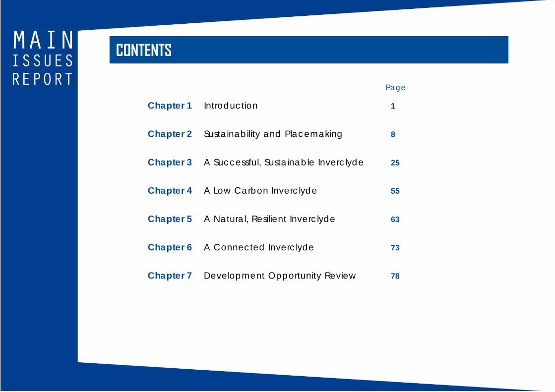
CONTENTS
Chapter 1 Introduction 1
Chapter 2 Sustainability and Placemaking 8
Chapter 3 A Successful, Sustainable Inverclyde 25
Chapter 4 A Low Carbon Inverclyde 55
Chapter 5 A Natural, Resilient Inverclyde 63
Chapter 6 A Connected Inverclyde 73
Chapter 7 Development Opportunity Review 78
Page

ISSUESISSUE 1 Sustainable Development Strategy
ISSUE 2 Major Areas of Change, Areas of Potential
Change and Development Option Sites
ISSUE 3 Central East Greenock
ISSUE 4 Promoting Town Centres
ISSUE 5 Greenock Town Centre
ISSUE 6 Supporting Business and Employment
ISSUE 7 Spango Valley, Greenock
ISSUE 8 Port Glasgow Industrial Estate
ISSUE 9 Enabling Delivery of New Homes
ISSUE 10 Housing Land Supply: Kilmacolm and Quarriers
Village
ISSUE 11 Housing Land Supply: Port Glasgow, Greenock,
Gourock, Inverkip & Wemyss Bay
ISSUE 12 Affordable Housing Policy
ISSUE 13 Gypsy/Traveller Policy
ISSUE 14 Valuing the Historic Environment
ISSUE 15 Delivering Heat and Electricity
ISSUE 16 Heat Networks
ISSUE 17 Planning for Zero Waste
ISSUE 18 Valuing the Natural Environment
ISSUE 19 Green Infrastructure
ISSUE 20 Allotments and Community Growing
ISSUE 21 Promoting Responsible Extraction of Resources
ISSUE 22 Managing Flood Risk and Drainage
ISSUE 23 Promoting Sustainable Transport and Active
Travel
ISSUE 24 Kilmacolm Village Centre Parking
ISSUE 25 Digital Connectivity
ISSUE 26 Development Opportunity Review

INTRODUCTION

1
INTRODUCTIONThis Main Issues Report is the first stage in the preparation of a
new Local Development Plan for the Inverclyde Council area.
The Local Development Plan sets out the Council’s strategy,
policies and proposals for the use of land and buildings within
Inverclyde, and, together with the Clydeplan Strategic
Development Plan, is the document the Council uses to
determine planning applications and provide advice on
development proposals.
The Main Issues Report focuses on what is likely to change
between the current Local Development Plan (adopted
August 2014) and the new Plan.
The Main Issues Report is not a policy document. Instead, it
offers an opportunity at an early stage in the Local
Development Plan process for the community and others with
an interest in the future development of Inverclyde to have a
say on the content of the new Plan and what it will say on the
key land use issues facing the area. It does this by setting out
options for how particular issues should be addressed, and by
inviting views on these options and alternatives.
THE LOCAL DEVELOPMENT PLAN PROCESS
Figure 1 illustrates the Local Development Plan process and
timeline, as established by the Council’s current Development
Plan Scheme (March 2016). The publication of the Main Issues
Report is the first formal stage in the preparation of a new Local
Development Plan. However, it has been preceded by a
significant level of engagement with key stakeholders, such
as Key Agencies, and a ‘Call for Sites’ exercise, which engaged
landowners/developers with an interest in the Inverclyde area.
FIGURE 1: INVERCLYDE LOCAL DEVELOPMENT PLAN TIMELINE

2
Responses received during the public consultation on the Main
Issues Report will help shape the Proposed Local Development
Plan, which will also be published for consultation. Any
unresolved objections to the Proposed Local Development
Plan will be subject to an Examination by a Scottish
Government appointed Reporter. Following the Examination,
the Plan will be modified to take account of the Reporter’s
recommendations, and will then be adopted, superseding the
current Local Development Plan.
STRUCTURE OF THE MAIN ISSUES REPORT
The Main Issues Report is structured around the four planning
outcomes identified in National Planning Framework 3 and
Scottish Planning Policy. It also includes a section focussing on
Sustainability and Placemaking, and an assessment of all the
development sites in the current Local Development Plan and
those sites that have been suggested to the Council through
pre-Main Issues Report engagement.
• Sustainability and Placemaking
• A Successful, Sustainable Inverclyde
• A Low Carbon Inverclyde
• A Natural, Resilient Inverclyde
• A Connected Inverclyde
• Development Opportunity Review
ACCOMPANYING DOCUMENTS
A number of documents have informed the preparation of
the Main Issues Report and are published alongside it to aid
the consultation exercise. These are:
• Monitoring Statement
• Interim Strategic Environmental AssessmentEnvironmental Report
• Habitats Regulations Appraisal
• Development Opportunity Review
• Call for Sites Assessment
• Housing Background Report
• Business and Industry Background Report
• Greenock Town Centre Background Report
• Allotments and Community Growing Background Report
• West Renfrew Hills Local Landscape Area DraftStatement of Importance

3
HOW TO RESPOND TO THE MAIN ISSUES REPORT
The Main Issues Report consultation period runs from 31 March
until 31 May 2017. During this time responses to the Main Issues
Report can be submitted by:
• e-mail to [email protected] with the subjectheading Main Issues Report
• completing the e-form available athttp://www.inverclyde.gov.uk/mir
• writing to Planning Policy, Regeneration & Planning,
Municipal Buildings, Clyde Square, Greenock, PA15 1LY
To discuss the Main Issues Report, please contact a member
of the Council’s Planning Policy team:
Alan Williamson 01475 712491
Ash Hamilton 01475 712463
Fiona Milne 01475 712411
Margaret Pickett 01475 712493

4
Document
National Planning Framework 3
Scottish Planning Policy
Status
Published by the Scottish
Government in June 2014.
Statutory framework for Scotland’s
long-term spatial development.
Published by the Scottish
Government in June 2014.
Influence on Local Development Plan
Recognises regeneration as the central focus of planning
across the Glasgow city region.
Identifies Central Scotland Green Network, which covers
Inverclyde, as a National Development.
Recognises Inverclyde as a potential site within the
National Renewables Infrastructure Plan.
Sets out two principal policies of Sustainability and
Placemaking. Also sets out requirements and expectations
for Local Development Plans including:
• application of a town centre first policy;
• promotion of, and allocation of land for, business and
industrial development;
• identification of a generous supply of land for housing
development;
• safeguarding of the historic and natural environment;
• support for change to a low-carbon economy, zero
waste and green infrastructure;
• avoidance of flood risk;
• promotion of sustainable transport and active travel:
and
• support for digital connectivity.
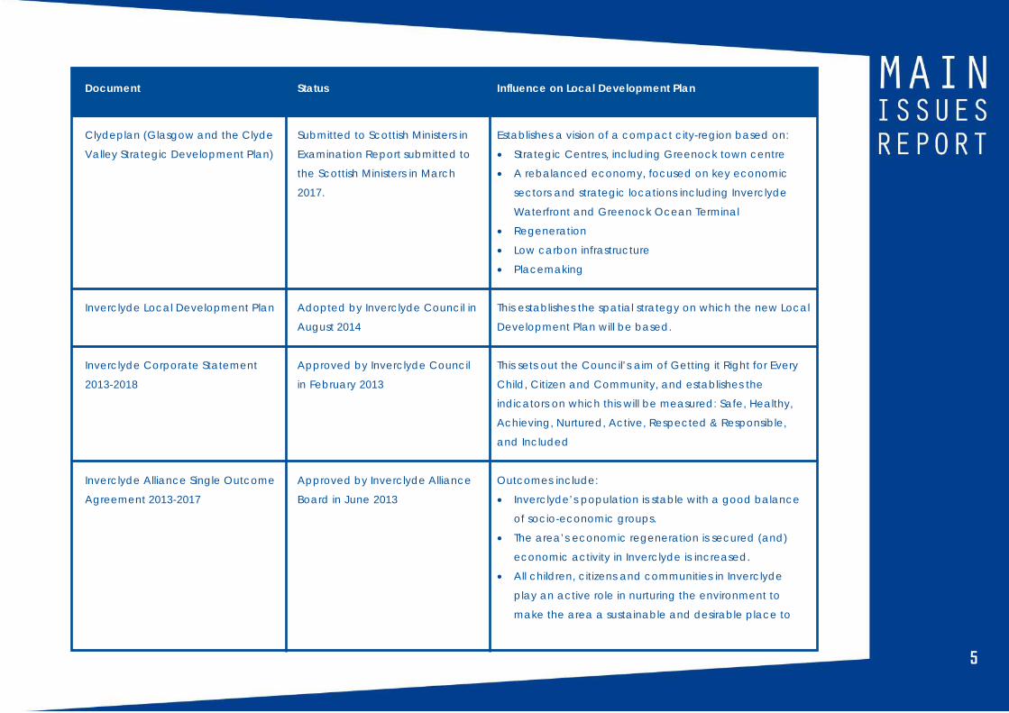
POLICY CONTEXTThe Inverclyde Local Development Plan, and the direction of travel set by this Main Issues Report, is shaped and influenced by a
number of national, regional and local policy and strategy documents and other initiatives. Principally, the Local development
Plan sets out how land and buildings should be used so that the Council’s vision, aims and outcomes for the area can be achieved.
5
Document
Clydeplan (Glasgow and the Clyde
Valley Strategic Development Plan)
Inverclyde Local Development Plan
Inverclyde Corporate Statement
2013-2018
Inverclyde Alliance Single Outcome
Agreement 2013-2017
Status
Submitted to Scottish Ministers in
Examination Report submitted to
the Scottish Ministers in March
2017.
Adopted by Inverclyde Council in
August 2014
Approved by Inverclyde Council
in February 2013
Approved by Inverclyde Alliance
Board in June 2013
Influence on Local Development Plan
Establishes a vision of a compact city-region based on:
• Strategic Centres, including Greenock town centre
• A rebalanced economy, focused on key economic
sectors and strategic locations including Inverclyde
Waterfront and Greenock Ocean Terminal
• Regeneration
• Low carbon infrastructure
• Placemaking
This establishes the spatial strategy on which the new Local
Development Plan will be based.
This sets out the Council’s aim of Getting it Right for Every
Child, Citizen and Community, and establishes the
indicators on which this will be measured: Safe, Healthy,
Achieving, Nurtured, Active, Respected & Responsible,
and Included
Outcomes include:
• Inverclyde’s population is stable with a good balance
of socio-economic groups.
• The area’s economic regeneration is secured (and)
economic activity in Inverclyde is increased.
• All children, citizens and communities in Inverclyde
play an active role in nurturing the environment to
make the area a sustainable and desirable place to
6
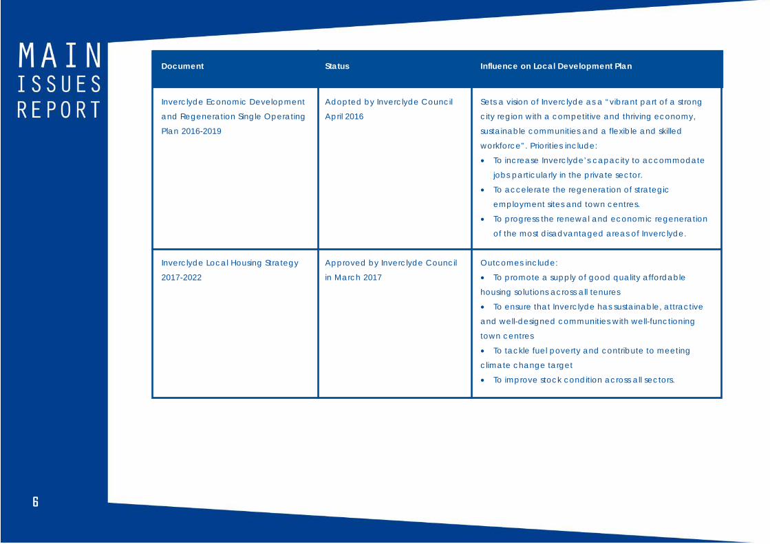
Document
Inverclyde Economic Development
and Regeneration Single Operating
Plan 2016-2019
Inverclyde Local Housing Strategy
2017-2022
Status
Adopted by Inverclyde Council
April 2016
Approved by Inverclyde Council
in March 2017
Influence on Local Development Plan
Sets a vision of Inverclyde as a “vibrant part of a strong
city region with a competitive and thriving economy,
sustainable communities and a flexible and skilled
workforce”. Priorities include:
• To increase Inverclyde’s capacity to accommodate
jobs particularly in the private sector.
• To accelerate the regeneration of strategic
employment sites and town centres.
• To progress the renewal and economic regeneration
of the most disadvantaged areas of Inverclyde.
Outcomes include:
• To promote a supply of good quality affordable
housing solutions across all tenures
• To ensure that Inverclyde has sustainable, attractive
and well-designed communities with well-functioning
town centres
• To tackle fuel poverty and contribute to meeting
climate change target
• To improve stock condition across all sectors.

777
SUSTAINABILITY AND PLACEMAKING

8
ISSUE 1 SUSTAINABLE DEVELOPMENTSTRATEGY
INTRODUCTION
Sustainable development is most commonly defined as
development that meets the needs of the present generation
without compromising the ability of future generations to meet
their own needs.
Placemaking is about directing the right development to the
right place and the creation of high quality places through a
design-led approach.
Sustainability and Placemaking are identified by Scottish
Planning Policy (2014) as the Principle Policies guiding the
planning system in Scotland.
CURRENT LOCAL DEVELOPMENT PLAN
The principles of sustainability and placemaking are
embedded in the Sustainable Development Strategy of the
current Local Development Plan through the policies
summarised in Figure 2. The strategy promotes a low carbon
future, based on sustainable travel and locations. It directs new
development to the existing urban area, particularly town
centres and brownfield sites, whilst protecting the green
network, including the green belt and countryside. It is
considered that this strategy remains valid and should be
carried forward into the next plan.

999
FIGURE 2: INVERCLYDE LOCAL DEVELOPMENT PLAN (2014)SUSTAINABLE DEVELOPMENT STRATEGY
Policy SDS1 – Climate Mitigation and Adaptation: Reducing
Carbon and Energy Use
This policy promotes the reduction of greenhouse gas emissions
and adaptation to climate change by improving the energy
efficiency of buildings; achieving renewable energy targets;
assisting the move to zero waste; protecting ‘carbon sinks; and
encouraging sustainable forms of travel.
Policy SDS2 – Integration of Land Use and Sustainable Transport
This policy promotes the safeguarding and enhancement of
sustainable forms of transport; an integrated transport system;
management of the road network; and directs new
development to locations accessible by a choice of transport
options.
Policy SDS3 – Placemaking
This policy promotes high quality placemaking in all new
development by having regard to Inverclyde’s historic urban
fabric, built cultural heritage and natural environment.
Policy SDS4 – Green Network
This policy promotes the safeguarding and enhancement of
green network routes, and the embedding of the green
network into new development.
Policy SDS5 – Development Within the Urban Area
This policy states a preference for all appropriate new
development to be located on previously used (brownfield)
land within the urban settlements.
Policy SDS6 – Promoting our Town Centres
This policy promotes and safeguards Inverclyde’s three town
centres (Greenock, Gourock and Port Glasgow).
Policy SDS7 – Regeneration & Renewal Priorities
This policy directs new investment and development to the
Waterfront and the Council’s renewal areas – the major Areas
of Change and Areas of Potential Change.
Policy SDS8 – Green Belt and Countryside
This policy presumes against the spread of the built-up area
into the Green Belt and sporadic development in the
Countryside.
ISSUE 1:Do you agree that the Sustainable Development Strategyset out in the current Local Development Plan remainsvalid and should be carried forward into the new Plan?
10
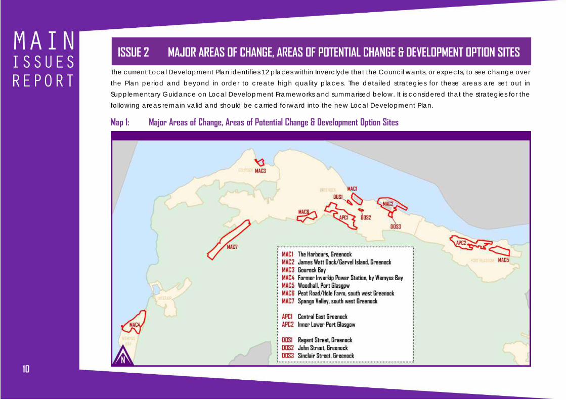
ISSUE 2 MAJOR AREAS OF CHANGE, AREAS OF POTENTIAL CHANGE & DEVELOPMENT OPTION SITESThe current Local Development Plan identifies 12 places within Inverclyde that the Council wants, or expects, to see change over
the Plan period and beyond in order to create high quality places. The detailed strategies for these areas are set out in
Supplementary Guidance on Local Development Frameworks and summarised below. It is considered that the strategies for the
following areas remain valid and should be carried forward into the new Local Development Plan.
Map 1: Major Areas of Change, Areas of Potential Change & Development Option Sites

111111
THE HARBOURS, GREENOCK (MAC1)
The Harbours sit in a central,
waterfront location just outside
Greenock town centre. The current
Local Development Plan sets out a
housing-led development strategy
for the Harbours, whilst recognising
that its location makes it suitable
for other uses such as tourism and
heritage, retail, food and drink,
financial and professional services,
and maritime related uses such as
marina facilities or ferry operations.
Map 2: MAC1 - The Harbours,Greenock
12
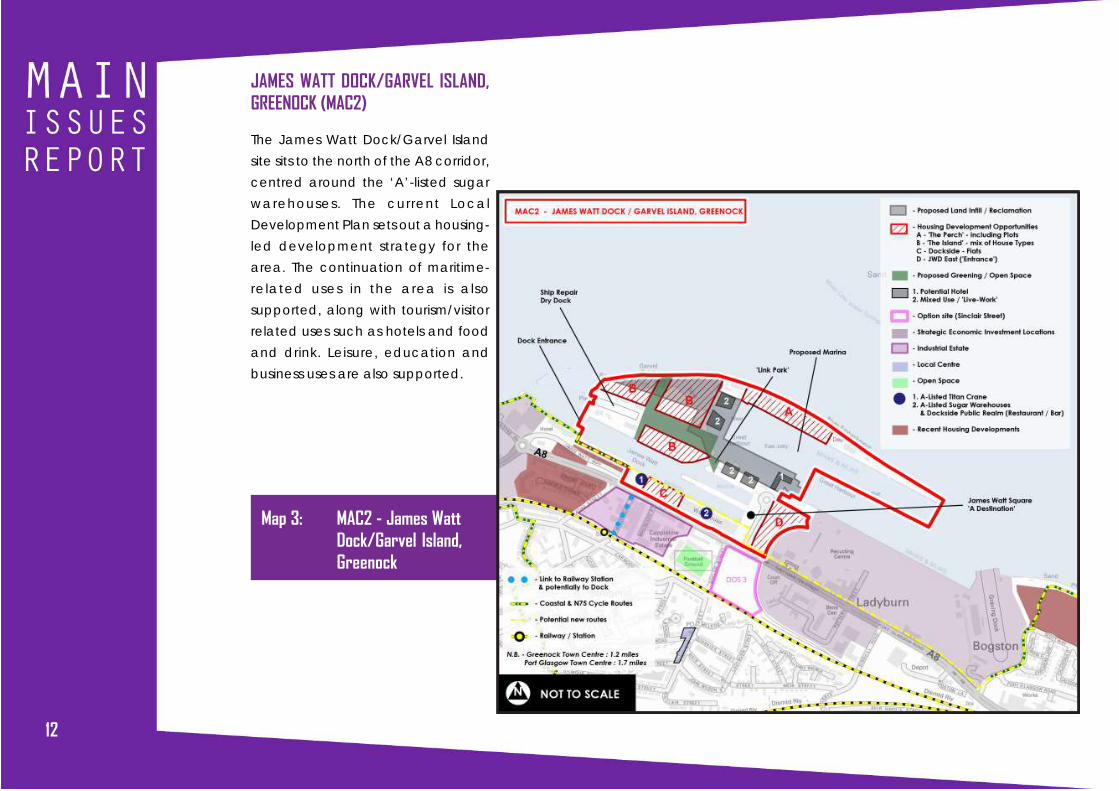
JAMES WATT DOCK/GARVEL ISLAND,GREENOCK (MAC2)
The James Watt Dock/Garvel Island
site sits to the north of the A8 corridor,
centred around the ‘A’-listed sugar
warehouses. The current Local
Development Plan sets out a housing-
led development strategy for the
area. The continuation of maritime-
related uses in the area is also
supported, along with tourism/visitor
related uses such as hotels and food
and drink. Leisure, education and
business uses are also supported.
Map 3: MAC2 - James WattDock/Garvel Island,Greenock

131313
GOUROCK BAY (MAC3)
Gourock Bay sits to the east of
Gourock town centre. The current
Local Development Plan strategy is
for a marina-led development
centred around the former Admiralty
jetty, to be complemented by
residential, sports and leisure and
tourism uses. The protection of views
into and out of the site is an important
part of the strategy for this area.
Map 4: MAC3 - Gourock Bay

14
FORMER INVERKIP POWER STATION (MAC4)
The current Local Development Plan strategy for
the former Inverkip Power Station site is for an
‘urban village’ development with new houses,
community and leisure facilities, hotel, food and
drink uses, neighbourhood retail and other
employment uses. Access would be via a new
roundabout on the A78. A significant part of the
site will be retained as greenspace.
Map 5: MAC4 - FormerInverkip Power Station
151515
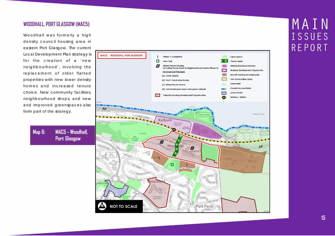
WOODHALL, PORT GLASGOW (MAC5)
Woodhall was formerly a high
density council housing area in
eastern Port Glasgow. The current
Local Development Plan strategy is
for the creation of a ‘new
neighbourhood’, involving the
replacement of older flatted
properties with new lower density
homes and increased tenure
choice. New community facilities,
neighbourhood shops, and new
and improved greenspaces also
form part of the strategy.
Map 6: MAC5 - Woodhall,Port Glasgow

16
PEAT ROAD/HOLE FARM, GREENOCK (MAC6)
Peat Road/Hole Farm is identified in the
current Local Development Plan for the
creation of a ‘new neighbourhood’. New
low density homes, open space,
community facilities and neighbourhood
retail are proposed.
Map 7: MAC6 - Peat Road/Hole Farm,Greenock

171717
INNER LOWER PORT GLASGOW (APC2)
Inner Lower Port Glasgow is a complex area stretching
eastwards from the town centre. At its core is the Clune Park
regeneration area, which is an area of privately owned houses,
the majority of which are vacant and considered to offer a
poor quality living environment. The preferred strategy for this
area, which is reflected in the current Local Development Plan,
is the demolition and redevelopment of the Clune Park area.
There are also large areas of unmanaged greenspace in the
area, which the Plan proposes to better integrate with the
residential environment.
Map 8: APC2 - Inner LowerPort Glasgow

18
REGENT STREET, GREENOCK (DOS1)
The Regent Street site sits in a central location within
a mixed use area. As such,the current Local
Development Plan identifies it as suitable for a range
of uses including business, industry, storage and
distribution, housing and residential institutions (e.g.
nursing home), and uses such as education. Uses
associated with the adjoining Greenock Central
railway station would also be acceptable.
Map 9: DOS1 - Regent Street, Greenock

191919
ISSUE 2: Do you agree that the strategies for the above sites, as set out in the current Local Development Planand associated Supplementary Guidance should be carried forward into the new Local Development Plan?
SINCLAIR STREET, GREENOCK (DOS3)
The Sinclair Street site sits in the A8 corridor, adjacent
to Cappielow football ground and within an otherwise
predominantly industrial area. The current Local
Development Plan identifies it as suitable for business,
industry, storage and distribution uses, non-residential
institution uses such as education, and assembly and
leisure uses associated with Cappielow football
ground.
Map 10: DOS3 - Sinclair Street, Greenock
20
The flats on John Street, Greenock, which was identified as a
Development Option Site (DOS2), have now been refurbished
and the site will be identified as part of the existing residential
area in the new Local Development Plan.
Central East Greenock (APC1) is identified in the current plan
for housing-led regeneration. Since the current Plan was
prepared a masterplan has been approved for the area, which
updates the current Plan’s strategy (Issue 3).
The Spango Valley site (MAC7) is identified in the current plan
for a mix of uses including business, residential and a new prison.
Representations have been received during pre-Main Issues
Report engagement from parties with interests in different parts
of the site, which seek changes to the current strategy (Issue
7).
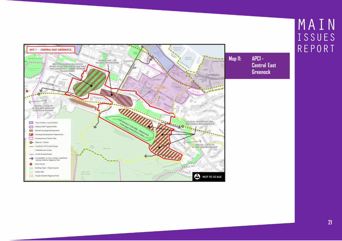
ISSUE 3 CENTRAL EAST GREENOCK (APC1)
The Central-East Greenock Area of Potential Change covers
an extensive mixed use area in central Greenock from Strone
to Drumfrochar (see Map 11). It includes housing opportunity
sites in Strone and Wellington Park in the east of the area,
vacant former industrial sites at its core and the high density
residential area of Broomhill/Drumfrochar to the west. The B7054
(Drumfrochar Road and Baker Street) runs through this area
and functions as a main alternative route through Inverclyde.
The concentration of vacant and derelict land in the area
therefore has an impact on perceptions of those who pass
through the area as well as a more direct impact on those
who live and work there.
The current Local Development Plan identifies the site as an
Area of Potential Change. Brownfield and greenfield land is
identified for residential development in Strone and Wellington
Park, with the adjacent KGV playing fields identified for a mix
of residential development and greenspace/playing field
enhancement. The former Tate and Lyle sites at the junction
of Drumfrochar Road and Lynedoch Street are identified for
either residential or industrial development. The Broomhill/
Drumfrochar residential area is identified for area renewal,
including the demolition and improvement of existing houses
and new build projects. The strategy also includes the
realignment of Baker Street to remove a sharp turn into
Drumfrochar Road.
212121
Map 11: APC1 -Central EastGreenock

22
Based on the Local Development Plan strategy, a masterplan
for Central East Greenock was approved in 2014 (see Map
12). The former Tate and Lyle sites are identified solely for
residential development by the masterplan. The realignment
of Baker Street is identified along with a Boulevard Strategy for
Drumfrochar Road and the creation of a linear park running
east-west through the area along a former railway line. A series
of other residential, commercial and industrial opportunities
and environmental improvements are identified by the
masterplan, which are broadly in line with the current Local
Development Plan. While the masterplan looks beyond the
boundaries of the Area of Potential Change, incorporating land
further to the east, it has less of a focus on the Strone/Wellington
Park area.
Map 12: Central East Greenock Masterplan 2014
232323
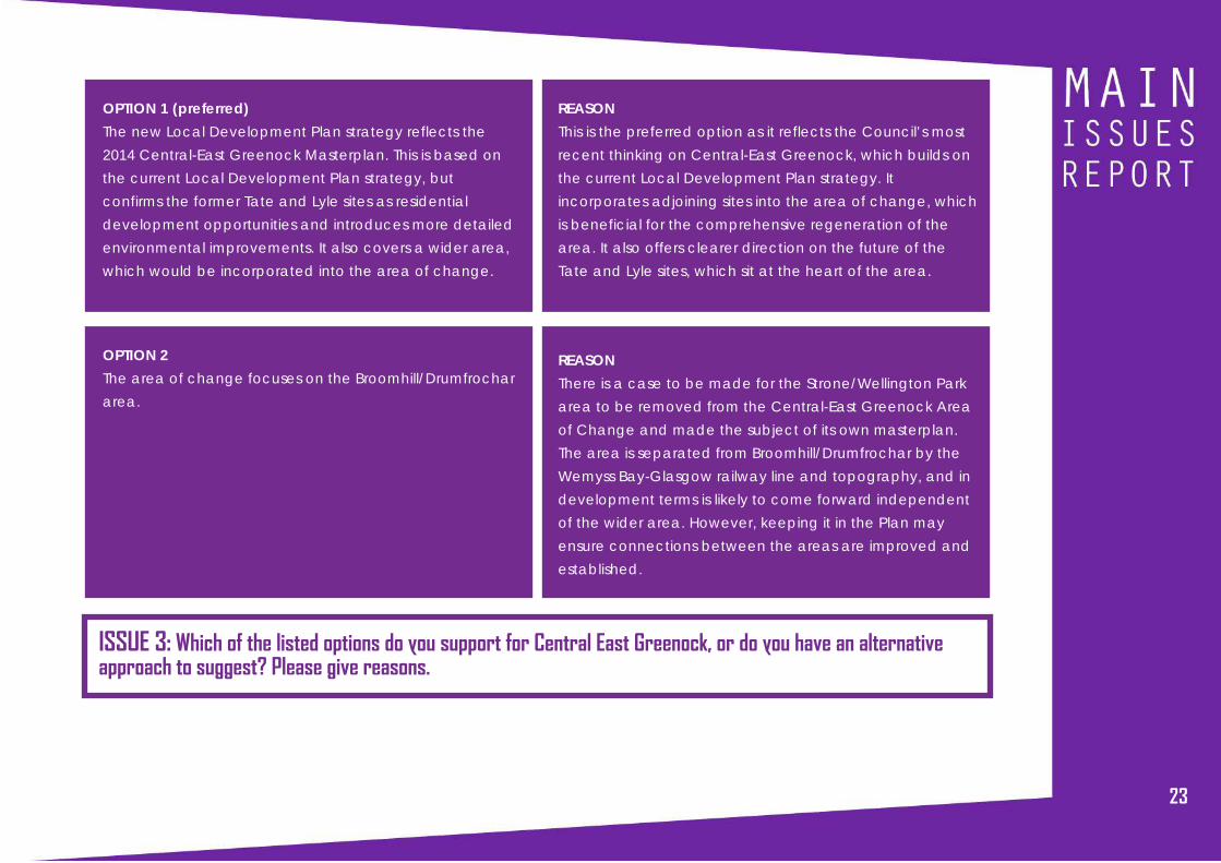
OPTION 1 (preferred)
The new Local Development Plan strategy reflects the
2014 Central-East Greenock Masterplan. This is based on
the current Local Development Plan strategy, but
confirms the former Tate and Lyle sites as residential
development opportunities and introduces more detailed
environmental improvements. It also covers a wider area,
which would be incorporated into the area of change.
OPTION 2
The area of change focuses on the Broomhill/Drumfrochar
area.
REASON
This is the preferred option as it reflects the Council’s most
recent thinking on Central-East Greenock, which builds on
the current Local Development Plan strategy. It
incorporates adjoining sites into the area of change, which
is beneficial for the comprehensive regeneration of the
area. It also offers clearer direction on the future of the
Tate and Lyle sites, which sit at the heart of the area.
REASON
There is a case to be made for the Strone/Wellington Park
area to be removed from the Central-East Greenock Area
of Change and made the subject of its own masterplan.
The area is separated from Broomhill/Drumfrochar by the
Wemyss Bay-Glasgow railway line and topography, and in
development terms is likely to come forward independent
of the wider area. However, keeping it in the Plan may
ensure connections between the areas are improved and
established.
ISSUE 3: Which of the listed options do you support for Central East Greenock, or do you have an alternativeapproach to suggest? Please give reasons.

24
A SUCCESSFUL, SUSTAINABLE INVERCLYDE

25252525
ISSUE 4 PROMOTING TOWN CENTRES
INTRODUCTION
There are three town centres in Inverclyde; Greenock, Gourock
and Port Glasgow, each serving a distinct but complementary
purpose.
Greenock is the largest town centre in Inverclyde, drawing
visitors from across the authority area and beyond, particularly
parts of Argyll and Bute, and as such it is identified as a Strategic
Centre in the Clydeplan Strategic Development Plan. It offers
Inverclyde’s largest concentration of food and non-food
shopping, and a wide range of non-retail services and
businesses such as a cinema, the Waterfront Leisure Centre,
the McLean Museum and Art Gallery, the Beacon Arts Centre,
the Greenock West College Scotland campus and a number
of restaurants, pubs and nightclubs that provide evening
activity. It is also an important employment hub, with a number
of large offices located there.
Port Glasgow town centre’s role has changed in recent years
from mainly offering convenience shopping for the town’s
residents to offering large format food and non-food shopping,
which draws shoppers from across Inverclyde.
Greenock and Port Glasgow town centres have both been
the subject of design charrettes (in 2016 and 2014 respectively),
which have generated masterplans and action plans for the
centres. Key projects from these plans will be incorporated into
the new Local Development Plan.
Gourock serves as a convenient centre for the residents of the
town and to travellers and commuters making use of the ferry
connections to Argyll and Bute. Its waterfront location,
traditional format and concentration of independent shops
and cafes mean that it also attracts day visitors from across
Inverclyde and beyond. It has benefitted from recent
investment in its railway station, road network and parking
facilities, and environmental improvements along the
waterfront and at the pierhead.
CURRENT LOCAL DEVELOPMENT PLAN
The current Local Development Plan (2014), through Policy
TCR1, identifies a network of centres, including Greenock, Port
Glasgow and Gourock town centres, and 9 local centres. Policy
TCR2 sets out a sequential approach, identifying the town
centres as the preferred location for the development of town
centre uses, with Greenock Central Area as first choice
location. Small scale retailing to meet local needs is supported
in local centres and out-of-centre/outwith the centres, where
it will not adversely affect the vitality and viability of the
designated centres.
ISSUE 4: Do you agree that the approach to Town Centres and Retailing set out in the current Local DevelopmentPlan remains valid and should be carried forward into the new Plan?

26
Greenock is the largest of Inverclyde’s town centres, and serves
the Inverclyde area and beyond for food and non-food
shopping and a range of other services.
The current Local Development Plan splits the Town Centre
into a Central Area and an Outer Area (see Map 13). The
ISSUE 5 GREENOCK TOWN CENTRECentral Area is the preferred location in Inverclyde for
investment in town centre uses. Within this Central Area is a
Retail Core, which Policy TCR4 of the current Local
Development Plan splits into 4 areas and limits the ground floor
frontage in each to no more than 25% non-Class 1 (shops)
uses (see Map 14). The purpose of this policy is to protect
retailing as the main activity in this area. Policy TCR5 of the
current Local Development Plan directs different non-retail uses
to the different divisions of the Outer Area based on their
existing character and function.
Map 13: Greenock Town Centre Retail Coreand Outer Area Divisions

27272727
The number of people shopping in Greenock town centre
decreased between 2008 and 2012 and the proportion of
vacant floorspace within the town centre has increased since
2011 with almost all of this increase being within the Central
Area and highest within the Retail Core.
These trends have raised the issue of whether a more relaxed
approach to the balance of uses allowed within Greenock
town centre should be introduced or whether it is important
for the planning system to continue to intervene to ensure shops
remain as the dominant use within the Central Area. Of rel-
evance to this are proposals for the Oak Mall received during
the Call for Sites for a more leisure-focussed offer to the east of
the Mall facing onto Clyde Square and an associated multi-
storey car park on Hunter Place.
Map 14: Greenock Town CentreRetail Core

28
OPTION 1 (preferred)
Retain the 4 areas within the Retail Core. Continue to
restrict the amount of non-retail floorspace in areas 2, 3
and 4 of the Retail Core to no more than 25% of non-retail
uses. Allow greater flexibility within Area 1, with exception
of Class 2 Uses (Financial and Professional Services).
Remove the divisions within the Outer Area to encourage
all town centre uses within each area, subject to the first
preference for new retail development being the Central
Area.
REASON
This approach seeks to retain retail as the predominant use in the
majority of the Central Area, but introduces a more flexible
approach in the easternmost part of the Oak Mall (Area 1) where
vacancy is highest and where there is greatest scope for
redevelopment or a repurposing towards a more leisure-based
offer.
The removal of the divisions within the Outer Area, and the
accompanying direction of different types of uses to particular
areas, will provide greater flexibility for town centre uses to be
developed where investors see opportunity.
REASON
This option would increase flexibility for investment in a range of
uses across the town centre. Whilst the Central Area would
remain the preferred location for retail investment, there would
be no restriction on non-retail uses, meaning the focus of retail
uses in this area may become less dominant.
REASON
This option is not preferred as it is considered to be too inflexible
at a time when town centres should be seeking investment in a
range of uses so as to maximise footfall. It can also be a complex
policy to apply and difficult for investors to understand where
limits on non-retail uses have been reached.
OPTION 2
Remove restriction on non-retail uses from the Retail Core.
Remove the divisions within the Outer Area.
OPTION 3
No Change. Continue to restrict the amount of non-retail
floorspace in the 4 sections of the Retail Core to no more
than 25% and to encourage the specified uses within the
different sections of the Outer Area.
ISSUE 5: Which of the listed options do you support for Greenock Town Centre, or do you have an alternative approachto suggest? Please give reasons.

29292929
ISSUE 6 SUPPORTING BUSINESS ANDEMPLOYMENT
INTRODUCTION
Inverclyde’s economy has seen a return to growth in recent
years, with unemployment falling by 5.5% and the number of
enterprises increasing by 21% between 2011-2016.
Inverclyde Council and our local Urban Regeneration
Company, Riverside Inverclyde, continue to work together to
maximise the economic potential of the area, with a focus on
improving the availability of business premises and the quality
of the wider physical environment, boosting skills and creating
more and better jobs. In development terms, this approach
has delivered new, high quality offices at Riverside Business
Park and four light industrial units at Kelburn Business Park, along
with refurbished or re-developed business space at Custom
House and Victoria House in Greenock, Scarlow House in Port
Glasgow and Municipal Buildings in Gourock. A programme
of town centre regeneration, public realm and environmental
improvements in Port Glasgow, Greenock and Gourock is also
ongoing.
The local tourism industry, which is a key growth sector in
Inverclyde, has been boosted by the success of the cruise liner
business at Greenock Ocean Terminal, where there has been
a 194% rise in the numbers of liners and a 393% rise in the number
of passengers between 2007 and 2015.
While progress is being made, we need to attract more private
sector businesses and investment, support local businesses to
grow, develop more small and medium-sized businesses, and
boost skills. This is key to Inverclyde’s future prosperity as it will
create new job opportunities, help retain the existing
population, attract new people to the area, and support and
enhance local services.
Local Development Plans can support economic activity and
growth by identifying the quantity and choice of development
land required to meet the needs of different economic sectors,
particularly growth sectors such as leisure and tourism, marine
engineering and financial and business services. A flexible and
positive policy framework can also enable businesses to adapt
to changing economic circumstances and realise new
opportunities. In addition, by identifying any infrastructure
requirements and associated costs relating to development
sites, Local Development Plans can also give the confidence
needed to secure private sector investment.
Inverclyde has seen a significant economic shift in the last 30
years, most notably from a manufacturing to a service based
economy. In some business and industrial areas this has left a
legacy of underused properties and vacant land. In such
circumstances, Scottish Planning Policy directs Local
Development Plans to consider allocating alternative uses on
these sites.
The Clydeplan Strategic Development Plan (2016) sets out a
long term vision for a rebalanced low carbon economy. To
support this vision, the Spatial Development Strategy identifies
30
22 Strategic Economic Investment Locations (SEILs). Inverclyde
has one SEIL, the ‘Inverclyde Waterfront’, which is identified
for Green Technologies and Business and Financial Services.
To further support economic growth in the Glasgow city-region,
the UK Government and the eight local authorities have
agreed a Glasgow and Clyde Valley City Deal, which includes
a £1.13 billion infrastructure fund aimed at progressing key
development sites and projects over a twenty year period.
The fund supports 20 large scale projects, three of which are in
Inverclyde, located at Inverkip Power Station, and Ocean
Terminal and Inchgreen in Greenock. Together, these projects
will improve our local transport network, deliver key
regeneration and development projects and encourage
significant private sector investment into the area.
CURRENT LOCAL DEVELOPMENT PLAN
The Local Development Plan safeguards key business and
industrial areas, while also providing scope for other uses to be
considered in areas with long term physical constraints or
marketability issues. A generous supply of marketable
development land is identified to meet anticipated demand
and the locational requirements of different sectors and sizes
of businesses. Proposals for working from home and for tourist
facil it ies and accommodation are encouraged and
supported. Its is considered that the current approach remains
valid and should be carried forward into the the new plan.
ISSUE 6: Do you agree that the approach to economy and employment set out in the current Local DevelopmentPlan remains valid and should be carried forward into the new Plan?
To inform the preparation of this Main Issues Report, a review of
the business and industrial development opportunities identified
in the current Local Development Plan was carried out. This
review considered a wide range of issues, including proximity
to transport networks, market attractiveness, site effectiveness,
environmental impacts and the potential for alternative
uses. Spango Valley and Port Glasgow Industrial Estate
have been identified as Main Issues 7 and 8, in order to
enable a debate on the most appropriate way to progress
development on these sites.
31313131
ISSUE 7 SPANGO VALLEY, GREENOCK (MAC7)
Spango Valley is a 56 hectare development area located on
the south western edge of Greenock, between the A78 and
the Glasgow to Wemyss Bay railway line. The majority of the
this area was originally developed by IBM in the 1950’s for the
manufacture of various microelectronic products, with the
former Greenock High School located within the northern part.
IBM’s operations gradually reduced over a number of years
and ceased completely in September 2016, while the former
school buildings were demolished in 2013. The area is now
under three ownerships. The Scottish Prison Service own the
vacant land to the north (area B in Map 15), while the vacant
land and buildings in the central area (A & C) and the vacant
land to the south (D) are under private ownerships.
Spango Valley is identified as a Major Area of Change (MAC7)
in the current Local Development Plan, which reflects the fact
that this is a large scale development area that is expected
to undergo significant change. Following a 2011 planning
permission, the northern area (B) is identified for a new prison.
The central area (A) is safeguarded for business and industrial
uses, in line with a Development Framework submitted by the
previous owner, which sought to restructure and refurbish the
existing commercial units and improve marketability. It was
acknowledged that a wider range and mix of uses was
required on the remaining areas, which had been largely
vacant for over 10 years. The Local Development Plan therefore
identifies area C for housing and neighbourhood retail, with
area D identified for business and industrial, recreation and
leisure, and renewable energy uses.
Following discussions with the Scottish Prison Service, the
allocation for a prison remains valid and it is proposed to carry
this forward into the new Local Development Plan. The main
issue in Spango Valley relates to areas A, C and D. There is a
need to review the current Local Development Plan approach
to these areas as the proposed restructuring and refurbishment
of the central business area (A) has not been progressed and
the majority of the buildings are now derelict and likely to be
demolished. In addition, no firm development interest has been
Map 15: Spango Valley, Greenock - Current LocalDevelopment Plan Zoning

32
expressed in developing the southern area (D) for the business/
industrial, renewable energy or leisure and recreation uses
identified in the Local Development Plan. With a total of 3.55ha
of business and industrial land developed in the past five years,
and eight other ‘marketable’ allocations in Inverclyde, totalling
10.14ha, there is a case for reducing the scale of business and
industrial land currently identified at Spango Valley. Such a
reduction would provide scope to expand the scale of housing
development across the site, enable a wider range of uses to
be considered, and allow a comprehensive development
framework, covering the entire site, to be developed.
During the Call for Sites in July 2016 a mixed use proposal for
approximately 60% residential and 40% commercial, including
a mix of business and industrial, leisure/tourism and renewable
energy uses, was submitted for the central area (see Map 16).
A mixed use proposal for up to 200 houses (approx. 80%) and
6,000sqm of commercial and business and industrial (approx.
20%) was also submitted for the southern area (see Map 17).
Map 17: Developer Proposals for Spango Valley (south)
When viewed together, both proposals constitute an
approximate spilt of 70% residential and 30% commercial uses
across both sites.
The Council has concerns about proposals for different parts
of the site being developed in isolation, and would also prefer
to see more of the site retained for business and industrial uses.
Map 16: Developer Proposals for Spango Valley (north)

33333333
OPTION 1 (preferred)
Preparation of a comprehensive Development Framework
covering the full site (and all ownerships).
Identify up to 50% of the combined developable area for
housing, with at least 35% retained for business and
industrial uses (Class 4, 5 and 6). The remaining area
should be made up of other uses, including
neighbourhood retail.
REASON
This option is preferred because a coordinated and
comprehensive approach will ensure the most appropriate
layout of uses and the creation of a successful place. It will also
ensure that any infrastructure requirements and constraints are
jointly and fully addressed.
The preferred scale and mix of uses will meet local housing need,
provide employment opportunities, and enable local services to
be delivered and maintained. It will also ensure that some
business and industrial land is retained to support the future
economic growth of Inverclyde.
REASON
This option is not preferred because the development of the site
based on land ownership, and not on a comprehensive basis,
would result in a sub-optimal solution and the loss of an
opportunity to create a successful place. This level of housing
would also reduce the scope for commercial/employment
generating uses in the area, particularly business and industrial
uses.
OPTION 2
Allocate both sites for residential-led mixed use, in line
with the proposals submitted by the respective owners.
ISSUE 7: Which of the listed options do you support for Spango Valley, or do you have an alternative approach tosuggest? Please give reasons.
34
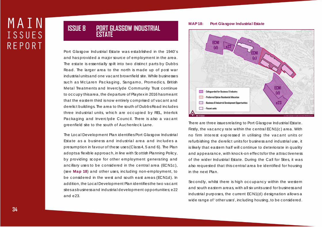
ISSUE 8 PORT GLASGOW INDUSTRIALESTATE
Port Glasgow Industrial Estate was established in the 1940’s
and has provided a major source of employment in the area.
The estate is essentially spilt into two distinct parts by Dubbs
Road. The larger area to the north is made up of post war
industrial units and one vacant brownfield site. While businesses
such as McLaren Packaging, Sangamo, Promedics, British
Metal Treatments and Inverclyde Community Trust continue
to occupy this area, the departure of Playtex in 2016 has meant
that the eastern third is now entirely comprised of vacant and
derelict buildings. The area to the south of Dubbs Road includes
three industrial units, which are occupied by REL, Interlok
Packaging and Inverclyde Council. There is also a vacant
greenfield site to the south of Auchenleck Lane.
The Local Development Plan identifies Port Glasgow Industrial
Estate as a business and industrial area and includes a
presumption in favour of these uses (Class 4, 5 and 6). The Plan
adopts a flexible approach, in line with Scottish Planning Policy,
by providing scope for other employment generating and
ancillary uses to be considered in the central area (ECN1c),
(see Map 18) and other uses, including non-employment, to
be considered in the west and south east areas (ECN1d). In
addition, the Local Development Plan identifies the two vacant
sites as business and industrial development opportunities; e22
and e23.
MAP 18: Port Glasgow Industrial Estate
There are three issues relating to Port Glasgow Industrial Estate.
Firstly, the vacancy rate within the central ECN1(c) area. With
no firm interest expressed in utilising the vacant units or
refurbishing the derelict units for business and industrial use, it
is likely that eastern half will continue to deteriorate in quality
and appearance, with knock-on effects for the attractiveness
of the wider Industrial Estate. During the Call for Sites, it was
also requested that this central area be identified for housing
in the next Plan.
Secondly, whilst there is high occupancy within the western
and south eastern areas, with all six units used for business and
industrial purposes, the current ECN1(d) designation allows a
wide range of ‘other uses’, including housing, to be considered.

35353535
This is significant as it could, potentially, contribute to the further
loss of business and industrial units within the estate. It should
also be noted that during the Call for Sites it was requested
that the ECN1(d) area to the south of Dubbs Road be identified
for housing in the next Plan.
Thirdly, there has been no firm developer interest in the e23
development opportunity, which is largely indistinguishable
from the green belt and on a relatively steep slope.
The options below consider whether the current Local
Development Plan approach should be carried forward, or
whether an alternative approach is required.
OPTION 1 (preferred)
With regard to the current ECN1(c) area, allocate the
eastern part for housing and retain the (c) designation on
the western part.
Re-designate the current ECN1(d) areas to ECN1(c).
Delete e23 as a business and industrial development
opportunity and re-designate as green belt.
REASON
This option is preferred because the eastern part of ECN1(c) is
now wholly comprised of vacant and derelict units and no firm
interest has been expressed in leasing or refurbishing them. With a
combination of housing and open space to the south, north and
east, it is considered that a housing allocation would be the most
appropriate alternative use for this area.
Re-designating the western and south eastern areas to ECN1(c)
would strengthen support for the existing businesses by retaining
the presumption in favour of Class 4, 5 and 6 and restricting other
uses to those which contribute to permanent employment or
those supportive of existing businesses.
Re-designating e23 as green belt reflects the longstanding lack of
interest in developing this site for business and industrial uses and
its location on the edge of the green belt.
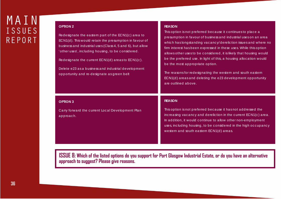
36
OPTION 2
Redesignate the eastern part of the ECN1(c) area to
ECN1(d). This would retain the presumption in favour of
business and industrial uses (Class 4, 5 and 6), but allow
‘other uses’, including housing, to be considered.
Redesignate the current ECN1(d) areas to ECN1(c).
Delete e23 as a business and industrial development
opportunity and re-designate as green belt
REASON
This option is not preferred because it continues to place a
presumption in favour of business and industrial uses on an area
which has longstanding vacancy/dereliction issues and where no
firm interest has been expressed in these uses. While this option
allows other uses to be considered, it is likely that housing would
be the preferred use. In light of this, a housing allocation would
be the most appropriate option.
The reasons for redesignating the western and south eastern
ECN1(d) areas and deleting the e23 development opportunity
are outlined above.
REASON
This option is not preferred because it has not addressed the
increasing vacancy and dereliction in the current ECN1(c) area.
In addition, it would continue to allow other non-employment
uses, including housing, to be considered in the high occupancy
western and south eastern ECN1(d) areas.
OPTION 3
Carry forward the current Local Development Plan
approach.
ISSUE 8: Which of the listed options do you support for Port Glasgow Industrial Estate, or do you have an alternativeapproach to suggest? Please give reasons.

37373737
ISSUE 9 ENABLING DELIVERY OF NEWHOMES
INTRODUCTION
Inverclyde is an attractive place to live. Kilmacolm and
Quarriers Village are amongst the most sought after residential
locations in Scotland. Greenock, Port Glasgow and Gourock
offer waterfront locations and stunning views over the Firth of
Clyde in locations close to services, including a modernised
school estate, and with excellent transport links to Glasgow.
Inverkip and Wemyss Bay are attractive coastal villages.
However, the population of Inverclyde has continued to fall
and, despite extensive investment in housing, there remain
areas of low demand and poor quality housing, such as in the
Clune Park area of Port Glasgow. Addressing these issues are
priorities for the Council and its partners, including River Clyde
Homes and Riverside Inverclyde.
The planning system can most directly influence these issues
through the identification of land for new homes, particularly
where new housing development would help regenerate the
urban area, and also by ensuring that new development is of
a standard that will create successful and sustainable places
where people will want to live.
CURRENT LOCAL DEVELOPMENT PLAN
The housing development strategy of the current Local
Development Plan builds on the broad strategy of previous
plans to improve the urban environment, safeguard and
enhance residential amenity, and provide direction for the
social, economic and physical regeneration of Inverclyde. It
also continues the longstanding sustainable land use planning
objective to support the development of mixed communities
by maximising new building on urban brownfield sites. The
strategy aims to ensure there is no land supply constraint to
the provision of a good range, choice and distribution of
housing sites. It is considered that this approach remains valid
and should be carried forward into the new Plan.
Demand for private housing is calculated on the basis of
housing market areas, which are areas within which people
are most likely to move house. Inverclyde has two housing
market areas. Kilmacolm and Quarriers Village make up part
of the Renfrewshire Sub-Market Area, while the rest of
Inverclyde falls within the Inverclyde Housing Market Area. The
need for affordable housing, particularly social rented housing,
is calculated at the local authority area level.
A Housing Need and Demand Assessment for the Inverclyde
area has been undertaken as part of the Clydeplan Strategic
Development Plan process. A comparison of housing need and
demand with the amount of housing expected to be delivered
in the period to 2024 on land already identified for housing
ISSUE 9: Do you agree that the HousingDevelopment Strategy set out in the current LocalDevelopment Plan remains valid and should becarried forward into the new Plan?
38
indicates that additional land for housing is required in both
the Kilmacolm/Quarriers Village and Inverclyde Housing Market
Areas. Options for addressing this need for land are addressed
in Issues 10 and 11.
The current Local Development Plan includes an Affordable
Housing Policy, which requires a contribution towards
affordable housing provision from specified housing sites. This
policy is supported by Supplementary Guidance. Issue 12
explores whether to continue with this approach.
There are no sites identified for Gypsies/Travellers in the current
Local Development Plan, or a policy to assess applications for
any proposals that may come forward. Issue 13 considers the
need for a policy.
ISSUE 10 HOUSING LAND SUPPLY -KILMACOLM & QUARRIERS VILLAGE
The Housing Need and Demand Assessment undertaken for
the Clydeplan Strategic Development Plan identifies a Housing
Land Requirement in the Kilmacolm/ Quarriers Village area for
130 new houses in the period 2012-2024. There were 3 housing
completions in the period 2012-2016 (on sites with a capacity
for 4 or more houses), leaving a requirement for 127 houses in
the period to 2024. The Council’s 2016 Housing Land Audit
predicts 75 houses will be delivered on land already identified
for housing in the period to 2024. This indicates a potential
shortfall of housing land for 52 houses.
Table 1: Kilmacolm & Quarriers Village HousingLand Requirement
As part of the Main Issues Report preparation process, a Call
for Sites exercise was undertaken. This resulted in a number of
suggestions to the Council of land with potential for housing
development in and around the Kilmacolm/ Quarriers Village
area. These suggestions have been assessed as part of the
Strategic Environmental Assessment of the Main Issues Report
and a summary of this and an assessment of other planning
factors is included in the Call for Sites Assessment background
report. Based on this assessment, the Main Issues Report sets
out options for addressing the housing land requirement in
Kilmacolm/ Quarriers Village. The preferred option is the
identification of land at Quarry Drive in Kilmacolm as a housing
development opportunity (see Map 19), with the identification
of land at Planetreeyetts as an alternative option (see Map
20). The other sites suggested to the Council as suitable for
(a) Housing Land Requirement 2012-2024
(from Clydeplan Strategic Development
Plan)
(b) Actual housing completions 2012-2016
(c) Housing Land Requirement 2016-2024
(a-b)
(d) Estimated housing completions 2016-2024
(based on 2016 Housing Land Audit)
(e) Shortfall in effective housing land for private
housing 2016-2024 (c-d)
130
3
127
75
52
39393939
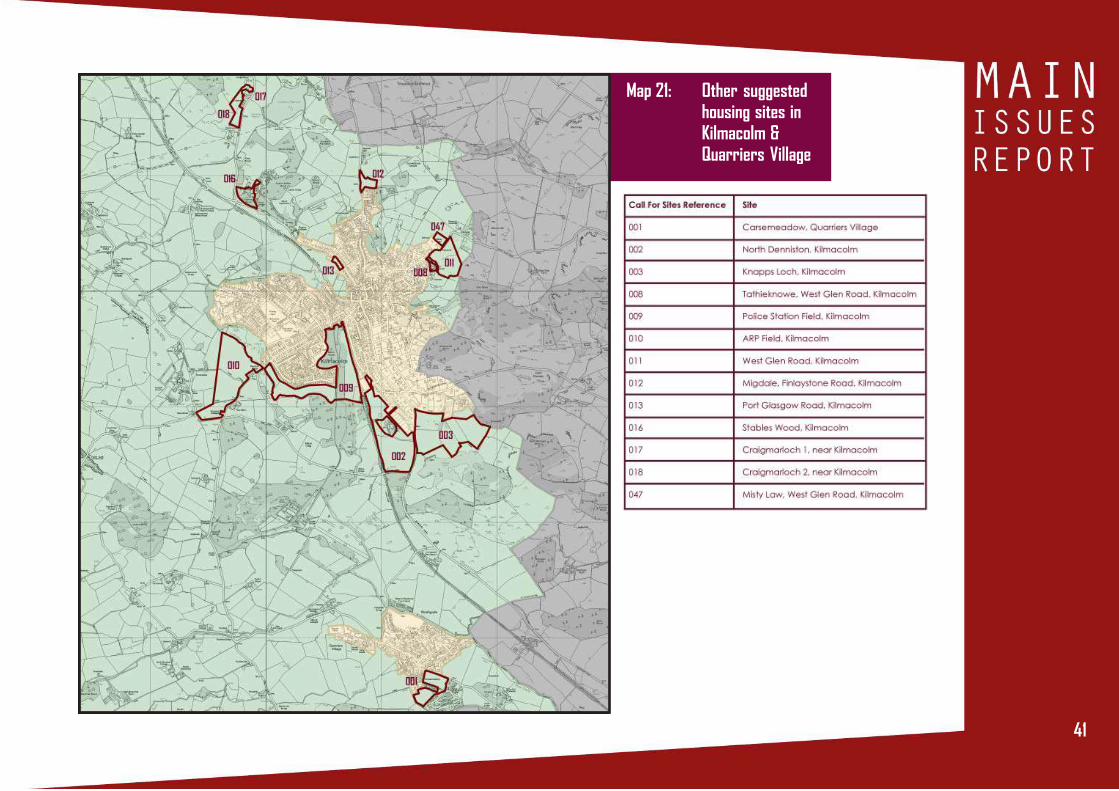
housing development are shown in Map 21 and comments on
these sites are also invited.
The Council recognises the distinctive qualities of Kilmacolm
and Quarriers Villages as places to live, and how the
countryside character and setting contributes to this. As such,
should the need for a release of land for housing be confirmed,
the Council will bring forward a development brief to ensure
that any impact on the character of the village is minimised
and that important characteristics of the identified site are
protected.
OPTION 1 (Preferred)
Further investigation of the capacity, suitability and
deliverability of land to the west of Quarry Drive in
Kilmacolm for new housing development.
REASON
Of the greenfield sites suggested for housing in the Kilmacolm area,
development of the land to the west of Quarry Drive is considered
likely to have least impact on the character and setting of
Kilmacolm. If developed, it is also considered to offer the
opportunity to create a robust green belt boundary in order to
prevent further incursion of development into the green belt.
REASON
Partial development of the land suggested for housing
development at Planetreeyetts in Kilmacolm may minimise the
impact on the character and setting of the village. However,
development of this site would extend the village in a northerly
direction and could lead to pressure for further expansion.
REASON
This option is not preferred as some of these options would: (1) have
an unacceptable adverse impact on the character and /or setting
of Kilmacolm or Quarriers Village; (2) provide for more housing land
than is required or lead to pressure for additional housing land
release; (3) not address the housing land requirement owing to
being too small or having deliverability issues.
OPTION 2
Further investigation of the capacity, suitability and
deliverability of land at Planetreeyetts, which is located in
Kilmacolm, for new housing development.
OPTION 3
Identify sites from Map 21 as housing development
opportunities.

40
ISSUE 10: Which of the listed options do you support for addressing housing land supply issues in Kilmacolmand Quarriers Village, or do you have an alternative approach to suggest? Please give reasons.
Map 19: Land west ofQuarry Drive,Kilmacolm
Map 20: Land atPlanetreeyetts,Kilmacolm
41414141
Map 21: Other suggestedhousing sites inKilmacolm &Quarriers Village

42
New private sector house completions in Port Glasgow,
Greenock, Gourock, Inverkip and Wemyss Bay (known as the
Inverclyde Housing Market Area) have increased year on year
since 2013, indicating a recovery in the private housing
market in the area.
The Housing Need and Demand Assessment undertaken for the
Clydeplan Strategic Development Plan identifies a Housing Land
Requirement in the Inverclyde Housing Market Area for 2120 new
private houses in the period 2012-2024. There were 429 housing
completions in the period 2012-2016, leaving a requirement for
1691 houses in the period to 2024. The Council expects 1039
houses to be delivered on land already identified for housing,
leaving a shortfall of land for 652 houses (see Table 3). This is
despite there being a significant amount of land identified for
housing development in the Inverclyde Housing Market Area,
as many of the sites identified for housing have issues associated
with them that prevent them being considered ‘effective’ i.e.
the Council cannot confidently predict that new houses will be
completed on these sites in the period to 2024. This might be
because of technical constraints such as contamination or road
access issues, which may in turn lead to developers not being
confident enough to invest in these sites. There is also a small
shortfall in land available for social rented housing, which is
expected to be addressed through the allocation of land at
Dubbs Road, Port Glasgow, and Duncan Street and Cumberland
ISSUE 11 HOUSING LAND SUPPLY - PORTGLASGOW/GREENOCK/GOUROCK/INVERKIP/WEMYSS BAY
Walk, Greenock, as well as windfall sites and additional
completions achieved through the application of the
affordable housing policy.
Table 2: Inverclyde Housing Market Area Housing LandRequirement
The Call for Sites exercise undertaken as part of the pre-Main
Issues Report process generated responses from the owners of
three of the largest brownfield sites in Inverclyde: Inverkip Power
Station, and Spango Valley and Ravenscraig Hospital in
Private
Sector
2120
429
1691
1039
652
Social
Rented
1100
269
831
793
38
Private
Sector
(a) Housing Land Requirement 2012-
2024 (from Clydeplan Strategic
Development Plan)
(b) Actual housing completions
2012-2016
(c) Housing Land Requirement
2016-2024 (a-b)
(d) Estimated housing completions
2016-2024 (based on 2016 Housing Land
Audit)
(e) Shortfall in effective housing land for
private housing in 2016-2024 (c-d)
43434343
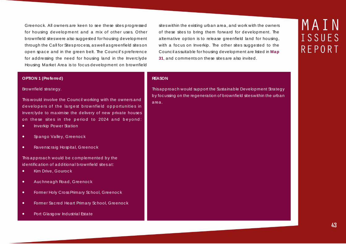
OPTION 1 (Preferred)
Brownfield strategy.
This would involve the Council working with the owners and
developers of the largest brownfield opportunities in
Inverclyde to maximise the delivery of new private houses
on these sites in the period to 2024 and beyond:
• Inverkip Power Station
• Spango Valley, Greenock
• Ravenscraig Hospital, Greenock
This approach would be complemented by the
identification of additional brownfield sites at:
• Kirn Drive, Gourock
• Auchneagh Road, Greenock
• Former Holy Cross Primary School, Greenock
• Former Sacred Heart Primary School, Greenock
• Port Glasgow Industrial Estate
REASON
This approach would support the Sustainable Development Strategy
by focussing on the regeneration of brownfield sites within the urban
area.
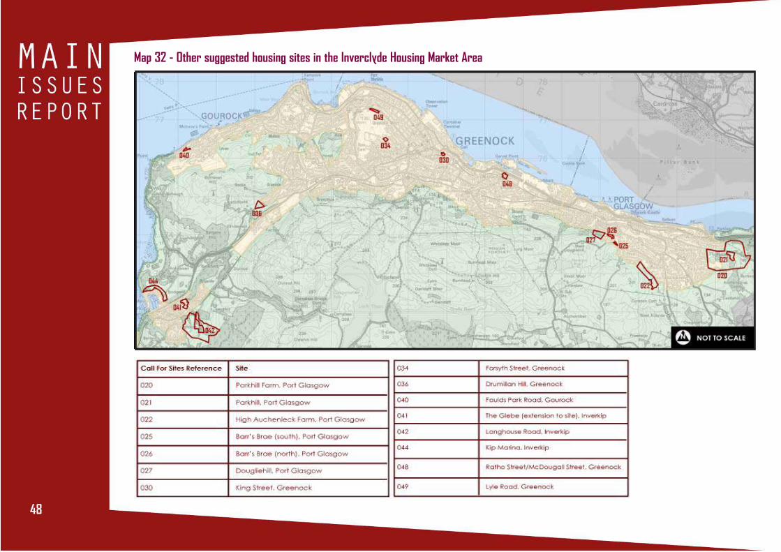
Greenock. All owners are keen to see these sites progressed
for housing development and a mix of other uses. Other
brownfield sites were also suggested for housing development
through the Call for Sites process, as well as greenfield sites on
open space and in the green belt. The Council’s preference
for addressing the need for housing land in the Inverclyde
Housing Market Area is to focus development on brownfield
sites within the existing urban area, and work with the owners
of these sites to bring them forward for development. The
alternative option is to release greenfield land for housing,
with a focus on Inverkip. The other sites suggested to the
Council as suitable for housing development are listed in Map
31, and comments on these sites are also invited.

44
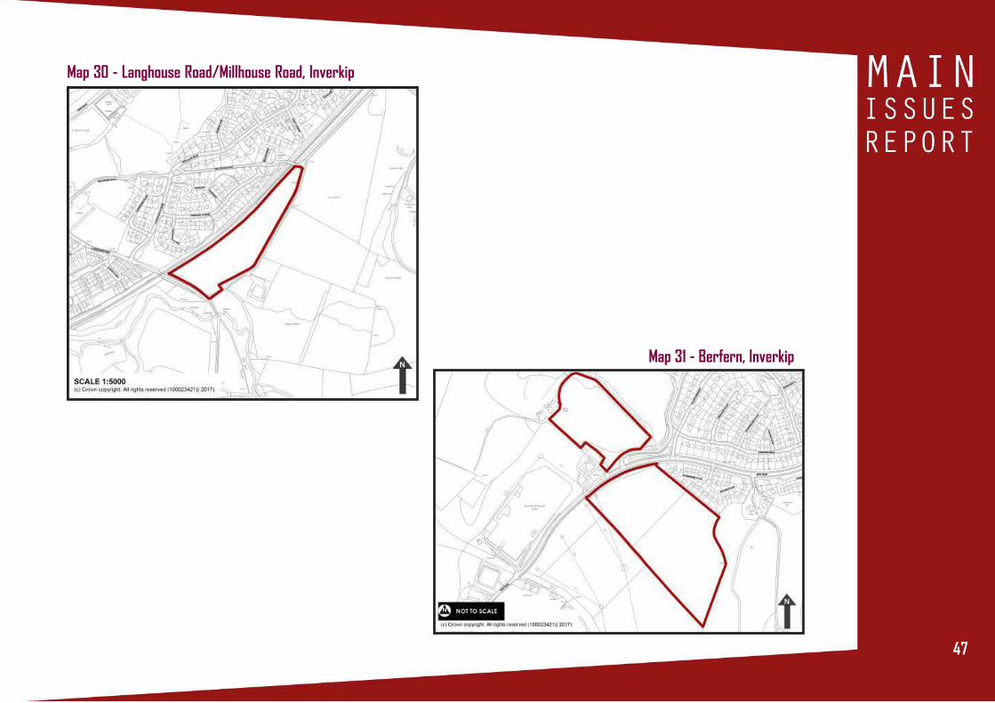
OPTION 2
Greenfield strategy
Further investigation of the capacity, suitability and
deliverability of land at:
• Langhouse Rd/Millhouse Rd, Inverkip
• Berfern, Inverkip
REASON
The identification of greenfield sites would not be consistent with
the Sustainable Development Strategy and may impact on the
viability of brownfield sites being brought forward for development.
OPTION 2
Identify sites from Table 4 as housing development
opportunities.
REASON
This option is not preferred as some of these options would: (1) have
an unacceptable adverse impact on open space (2) not address
the housing land requirement owing to being too small or having
deliverability issues.
ISSUE 11: Which of the listed options do you support for the Housing Land Supply in the Inverclyde Housing MarketArea, or do you have an alternative approach to suggest? Please give reasons.

45454545
Map 22 - Inverkip Power Station
Map 23 - Spango Valley, Greenock
Map 24 - Ravenscraig Hospital, Greenock
Map 25 - Kirn Drive, Gourock

46
Map 26 - Auchneagh Road, Greenock Map 27 - Former Holy Cross Primary School, Greenock
Map 28 - Former Sacred Heart Primary School, Greenock
Map 29 - Port Glasgow Industrial Estate
47474747
Map 30 - Langhouse Road/Millhouse Road, Inverkip
Map 31 - Berfern, Inverkip
48
Map 32 - Other suggested housing sites in the Inverclyde Housing Market Area

49494949
ISSUE 12 AFFORDABLE HOUSING POLICY
Policy RES4 of the current Local Development Plan relates to
affordable housing provision. It states that for residential
developments of 20 or more dwellings on identified sites,
developers will be required to provide a 25% affordable housing
contribution, or other agreed percentage. In exceptional
circumstances, developers may provide off site affordable
housing within the same Housing Market Area/Housing Need
and Demand Assessment sub-area or a commuted sum in lieu
of the other forms of provision.
The Draft Local Housing Strategy 2017-2022 shows that, despite
house prices declining between 2009 and 2014, there has been
no improvement in affordability, particularly for those on lower
incomes, indicating a continuing issue with the affordability of
entry-level housing. This is the case in both the Inverclyde
Housing Market Area and in Kilmacolm and Quarriers Village.
There is also evidence that private rent of larger properties (4
bed plus) is unaffordable for the majority of households on lower
incomes.
The current Local Development Plan affordable housing policy
is not straightforward. Its application to only certain specified
sites has caused confusion, and there is uncertainty as to
whether it is applicable to windfall sites. In practice, the
benchmark of 25% affordable housing contribution has not yet
been achieved through the application of the policy. The
opportunity is therefore being taken through the Main Issues
Report to examine whether to continue with an affordable
housing policy and what its requirements should be.
Affordable housing, South West Greenock

50
OPTION 1 (preferred)
Revise the Affordable Housing Policy to seek a 10% affordable
housing contribution from all private sector housing sites with
a capacity for 20 or more dwellings.
REASON
The draft Local Housing Strategy 2017-2022 supports the continuation
of an affordable housing policy in the new Local Development Plan.
The application of the policy to all sites is a more consistent approach.
The reduction of contribution to 10% reduces the impact on the
viability of private sector development.
OPTION 2
Remove the affordable housing policy i.e. do not seek an
affordable housing contribution from private sector sites.
REASON
This option would increase the viability, and therefore deliverability,
of private sector housing sites. However, it would not help to increase
tenure choice throughout the Council area.
OPTION 3
Retain the current Local Development Plan approach of
seeking a ‘benchmark’ of 25% affordable housing on
specified sites, to be provided on site or, subject to
negotiation, off-site or via a commuted sum.
REASON
This option is not preferred as it limits the application of the policy to
specified sites and in practice has not been successful in obtaining
25% on-site provision of affordable housing.
ISSUE 12: Which of the listed options do you support for the Affordable Housing policy, or do you have an alternativeapproach to suggest? Please give reasons.

51515151
ISSUE 13 GYPSY/TRAVELLER POLICY
There are currently no sites provided for Gypsies/Travellers in
Inverclyde, nor does the current Local Development Plan
identify a site or include a policy for assessing proposals for
such facilities. The Housing Need and Demand Assessment
undertaken for the Clydeplan Strategic Development Plan
does not identify the need for a Gypsy/Traveller site in
Inverclyde, although the Draft Inverclyde Local Housing
Strategy 2017-2022 states that consultation with Gypsy/Traveller
groups indicates there may be a lack of permanent stopping
sites in the region. Whilst a transit site was considered for
Inverclyde in 2013, with various locations proposed, after
extensive consultation it was decided not to pursue this
approach.
Scottish Planning Policy (2014) states that development plans
should address any need for Gypsy/Traveller sites that have
been identified through a Housing Need and Demand
Assessment and consider whether policies are required for
assessing proposals for small privately owned sites. Guidance
produced by PAS supports this, and provides an example of a
policy from the East Ayrshire Local Development Plan for the
assessment of proposals for sites (see Figure 5).
Figure 5: Example policy for assessing proposals for Gypsy/Traveller sites (from East Ayrshire Local Plan 2010)
The Council will assess any applications for small,privately owned Travellers’ Sites on their own meritsand will support the development of such sites whereall of the following criteria can be met:
(i) the site is in a location readily accessible to themain strategic road network;
(ii) the site does not adversely affect or impact onany areas of recognised nature conservation andbuilt heritage interest, sites of significant landscapequality and any existing surrounding uses;
(iii) the site can be accessed and serviced to thestandards of the Council’s Roads Division and otherservice providers;
(iv) the site is adequately screened and landscapedto the satisfaction of the Council; and
(v) the site does not cause any unacceptabledamage or detriment to the amenity of residents ofsurrounding properties.
Proposals which do not meet all these criteria will notbe supported by the Council.
52
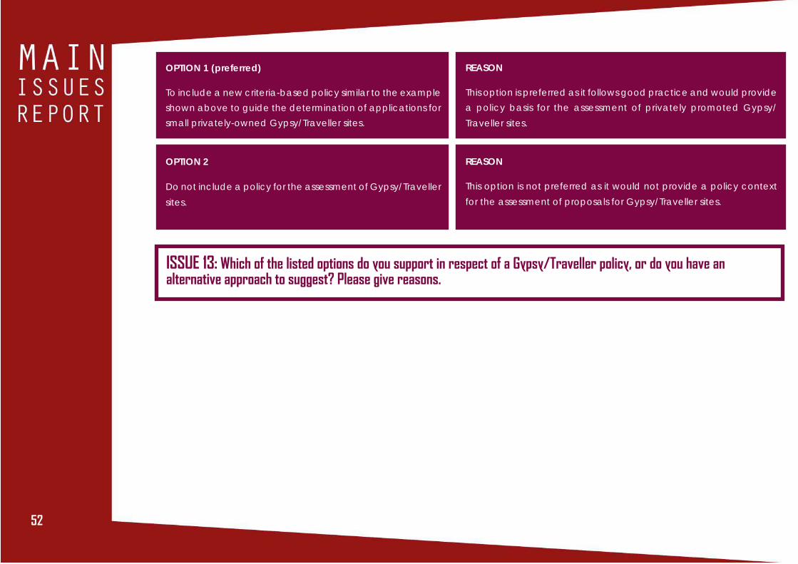
OPTION 1 (preferred)
To include a new criteria-based policy similar to the example
shown above to guide the determination of applications for
small privately-owned Gypsy/Traveller sites.
REASON
This option is preferred as it follows good practice and would provide
a policy basis for the assessment of privately promoted Gypsy/
Traveller sites.
OPTION 2
Do not include a policy for the assessment of Gypsy/Traveller
sites.
REASON
This option is not preferred as it would not provide a policy context
for the assessment of proposals for Gypsy/Traveller sites.
ISSUE 13: Which of the listed options do you support in respect of a Gypsy/Traveller policy, or do you have analternative approach to suggest? Please give reasons.

53535353
INTRODUCTION
Inverclyde has a rich and varied historic environment. There
are 8 conservation areas and 247 listed buildings. These include
A-listed buildings such as Newark Castle in Port Glasgow, the
Titan Crane on James Watt Dock, the Watt Library and McLean
Museum in Greenock, Wemyss Bay railway station, and
Windyhill in Kilmacolm, a small selection that gives an insight
into Inverclyde’s distinctive history. There are 3 designated
Gardens and Designed Landscapes at Ardgowan, Finlaystone
and Duchal. There are 33 Scheduled Monuments, which are
archaeological sites of national importance, and many more
sites of local importance.
CURRENT LOCAL DEVELOPMENT PLAN
The current Local Development Plan contains a suite of policies
which are used in association with the policies and guidance
of Historic Environment Scotland to protect the historic
environment within Inverclyde. This includes Policy HER6 and
associated Supplementary Guidance, which support enabling
development associated with the restoration of listed buildings.
It is considered that this approach remains valid and should
be carried forward into the new Plan.
ISSUE 14: Do you agree that the historic environment policies set out in the current Local Development Plan,particularly the Enabling Development policy, remain valid and should be carried forward into the new Plan?
ISSUE 14 VALUING THE HISTORIC ENVIRONMENT
Newark Castle, Port Glasgow

54
A LOW CARBON INVERCLYDE

5555
ISSUE 15 DELIVERING HEAT AND ELECTRICITY
INTRODUCTION
In 2007 Inverclyde Council signed up to Scotland’s Climate
Change Declaration, which commits the Council to reducing
its carbon emissions and adapting to the impacts of climate
change. Subsequently, under the provisions of the Climate
Change (Scotland) Act 2009, the Council has reported climate
change information on an annual basis. This reporting shows
that since 2012/13 the Council has reduced its carbon emissions
year on year, and by 2015/16, carbon emissions had reduced
22.5% from the 2012/13 baseline. This has been achieved
through measures such as a reduction in energy use in buildings
and the use of more energy efficient street lighting.
As well as the Council’s own endeavours to reduce carbon
emissions, through the planning system it has supported a
variety of renewable energy developments in Inverclyde
including onshore wind, solar and micro-hydro. Map 33 shows
where these are located.
CURRENT LOCAL DEVELOPMENT PLAN
The current Local Development Plan Policy INF1 and the
associated Supplementary Guidance on Renewable Energy
is supportive of development required for the generation of
energy from renewable resources, subject to assessment of
impact on a range of social, economic and environmental
resources. Through Policy INF2 the current Plan also requires
the installation of low and zero carbon generating
technologies in new developments in order to reduce CO2
emissions. It is considered that this approach remains valid and
should be carried forward into the new Plan.
ISSUE 15: Do you agree that the approach to renewable energy developments and energy efficiency in newdevelopments in the current Local Development Plan and associated Supplementary Guidance remains valid andshould be carried forward into the new Local Development Plan?

56
Map 33: Renewable Energy Infrastructure in Inverclyde

5757
ISSUE 16 HEAT NETWORKS
Heating forms the biggest element of energy use in Scotland
at over 55%, while the creation of heat produces 47% of
Scotland’s carbon emissions. It is the ambition of the Scottish
Government to largely decarbonise Scotland’s energy
system by 2050 and to achieve 1.5 terawatt-hours (TWh) of
heat demand through district or communal heating, with a
target of 40,000 homes connected by 2020.
Planning has a key role to play in the development of
communal heating systems through its involvement in the
location, layout and design of new development and
through its more general support for renewable energy
developments.
The planning priorities for heat are set out in National
Planning Framework 3, which supports the delivery of district
heating schemes as a means of achieving the Scottish
Government goals for renewable heat, with the aim to make
better use of heat sources, including unused and renewable
heat.
Scottish Planning Policy reflects the aims identified in the
National Planning Framework 3, encouraging district heating
systems in as many locations as possible across all local
authorities and directing that Local Development Plans
should:
• use heat mapping to identify opportunities for co-
locating developments with high heat demand with
those with high heat output
• identify where heat networks, heat storage and energy
centres exist or would be appropriate; and
• support the implementation of heat networks in as many
locations as possible and include policies to support their
implementation
A Scotland-wide Heat Map produced by Scottish Government
in 2014 (http://heatmap.scotland.gov.uk/) is intended to
support local authorities to incorporate heat mapping into
development plans and make best use of available heat
sources. It identifies existing sites of heat demand as well as
sources of heat supply to guide heat network development.

58
So far, one district heating system has been established in
Inverclyde, at Broomhill. An investment of £7M has been made
in a gas and biomass system, which operates through a central
boiler within a localised energy centre to provide heat and
hot water on demand to 555 homes. This district heating system
has contributed to renewable heat and climate change
targets through the reduction of the homes’ carbon footprint,
as well as working towards the commitment of tackling fuel
poverty by reducing residents’ fuel bills.
Figure 6 - Renewable Heat Generation and District Heating System
In the current Local Development Plan, Policy INF1 - Renewable
Energy is the policy against which renewable energy
development proposals are assessed. It does not make specific
reference to district heating/cooling systems. Whilst it would be
possible to determine proposals for district heating systems under
Policy INF1, the inclusion of a new policy to cover these types of
developments, which links to Supplementary Guidance on
Renewable and Low Carbon Energy, could be beneficial to
identify where district heating developments could be deployed
and to assess proposals.

5959
OPTION 1 (preferred)
Create a new policy on renewable heat and heat networks
with accompanying heat map. Amend the Supplementary
Guidance on Renewable Energy to refer to heat networks.
REASON
This would meet the requirements of National Planning Framework 3,
Scottish Planning Policy and the Clydeplan Strategic Development
Plan by providing a policy framework to promote and encourage
renewable heat opportunities, identify the most suitable locations
and enable their detailed assessment.
OPTION 2
Modify existing Policy INF1 to make reference to heat
networks and link to amended Renewable Energy
Supplementary Guidance incorporating Low Carbon Energy.
REASON
This would provide policy coverage for heat networks, but would not
provide a specific policy against which a detailed assessment of
proposed developments could be made.
OPTION 3
Determine heat network proposals against existing Policy INF1
and make no changes to Supplementary Guidance.
REASON
This does not make specific reference to heat networks, nor does it
make use of heat mapping to identify where such developments
could be implemented. Therefore, the policy is not sufficiently
promotional with regard to renewable heat and the creation of heat
networks.
ISSUE 16: Which of the listed options do you support for Heat Networks or do you have an alternative option to suggest?Please give reasons.

60
ISSUE 17 PLANNING FOR ZERO WASTE
INTRODUCTION
Inverclyde is well served in terms of waste services, particularly
recycling, with 45 neighbourhood recycling centres and a
further 2 centres for the recycling of bulky materials and garden
waste. Kerbside recycling services covering dry recyclables,
garden waste, food waste and glass are also available to many
households. The Council continues to expand these services
by rolling out its food collection and kerbside glass collection
services and introducing recycling services to tenemental
properties.
This approach has been particularly successful, with the
amount of household waste falling by 16% and recycling
increasing by 11.4% in the period from 2011-2015. Inverclyde
Council was one of only nine Councils in Scotland to exceed
the Scottish Government’s household waste recycling target
of 50% in 2013. In recognition of the Council’s achievements,
the Waste Strategy team was awarded the prestigious
Chartered Institute of Waste Management’s Local Authority
Waste Hierarchy award in 2014.
The Scottish Government approved a Zero Waste Plan in 2010,
which considers all waste to be a resource that should not,
whenever possible, simply be disposed of in landfill. The Zero
Waste Plan sets out a hierarchy for managing waste, in the
order of waste reduction, reuse, recycling and recovery (see
Figure 7); thereby leaving only a limited amount to be sent to
landfill. The Zero Waste Plan also sets out a number of targets,
including a requirement for 60% of household waste to be
recycled by 2020, increasing to 70% by 2025. To support the
Zero Waste Plan, the Waste (Scotland) Regulations 2012 placed
a responsibility on councils to provide a range of recycling
collections to households and commercial premises. By working
with residents and business, Inverclyde Council is now fully
compliant with these Regulations.
Scottish Planning Policy highlights a number of ways in which
the Local Development Plan can support the Zero Waste Plan.
It is important that the Plan encourages the minimisation of
waste produced during the construction and operation of all
new development, safeguards existing waste management
facilities and supports a range of technologies and industries
which seek to maximise the benefits of re-using waste. Whilst
Scottish Planning Policy and National Planning Framework 3
encourage development plans to identify locations for new
waste management facilities, there is not expected to be a
requirement for further waste disposal or recycling facilities in
Inverclyde during the period covered by the new Local
Development Plan.

6161
Figure 7 - The Waste Hierarchy
CURRENT LOCAL DEVELOPMENT PLAN
Policy INF3 of the current Local Development Plan (2014) sets
out criteria for assessing new waste management facilities,
including the need to comply with the principles of the Zero
Waste Plan, to cater primarily for waste arising from Inverclyde
and avoid adverse impacts on residential amenity and the
natural and built heritage. It is considered that this approach
remains valid and should be carried forward into the next Plan,
with the addition of criteria to safeguard existing waste
management facilities and promote new technologies which
seek to maximise the of re-use of waste. In addition, a new
criteria/policy will be considered to encourage waste
minimisation and re-use during the construction and operation
of all new development.
ISSUE 17: Do you agree that the approach to wasteset out in the current Local Development Plan remainsvalid and should be carried forward into the new Plan,subject to the amendments identified above?

62
A NATURAL, RESILIENT INVERCLYDE

6363
ISSUE 18 VALUING THE NATURALENVIRONMENT
INTRODUCTION
Inverclyde contains a wide variety of natural resources which,
when considered together, constitute a considerable asset to
the area. These stretch from the Firth of Clyde coastline to the
upland moorland which comprises much of Clyde Muirshiel
Regional Park. This natural environment provides the backdrop
for all activities that take place in Inverclyde. It is vital therefore
that these natural assets are protected and, where possible,
enhanced for present and future generations.
Many of the natural resources of Inverclyde benefit from the
protection of natural heritage designations. In Inverclyde there
are two international designations, namely the Inner Clyde
Estuary Special Protection Area and Ramsar site, protected as
a wintering habitat for redshanks, and the inland Renfrewshire
Heights Special Protection Area designated in 2007 as an
important breeding area for hen harriers. These, along with a
number of national Site of Special Scientific Interest
designations and many Local Nature Conservation Site
designations, protect the natural resource throughout
Inverclyde. Table 3 shows the number of natural heritage
designations in Inverclyde.
Table 3 - Natural Heritage Designations in Inverclyde
Scottish Planning Policy identifies the natural environment as
a valued national asset, which offers a wide range of
opportunities for enjoyment, recreation and sustainable
economic activity. It is the role of planning to protect, enhance
and promote access to the natural environment whilst
supporting its sustainable use.
Natural Heritage Designation
Special Protection Areas (SPA)/Ramsar
Special Protection Areas (SPA)
Site of Special Scientific Interest (SSSI)
Local Nature Conservation Site
Local Nature Reserve
Other Designations
Tree Preservation Order (TPO)
Regional Park
No.
1
1
7
52
2
No.
32
1

64
As well as designated natural heritage sites, the natural
environment incorporates a variety of elements, including:
• biodiversity comprising plant and animal species and
habitats;
• water environments such as rivers, lochs, wetlands and
coastal waters;
• woodland, hedgerows and individual trees, including
those covered by Tree Preservation Orders;
• locations for informal leisure and recreation; and
• open space within built up areas
CURRENT LOCAL DEVELOPMENT PLAN
The importance of the natural heritage assets and
environmental resources within Inverclyde is borne out by the
policies of the current Local Development Plan. These policies
protect the natural heritage designations, biodiversity and the
water environment whilst also safeguarding and promoting
the Green Network, trees and woodlands, and open space to
provide an environment where people can improve their
health and well-being. It is considered that this approach
remains valid and should be carried forward into the new Plan.
ISSUE 18: Do you agree that the natural heritage and environmental resources policies set out in the current LocalDevelopment Plan remain valid and should be carried forward into the new Plan?
Greenock Cut

6565
ISSUE 19 GREEN INFRASTRUCTURE
INTRODUCTION
Green infrastructure comprises a number of resources,
including both formal and informal open space such as parks,
woodlands, playing fields, core paths and allotments. It also
includes water courses and bodies of water. The combined
elements of Green Infrastructure are harnessed to provide
communities with important ecological, economic and social
benefits, such as flood prevention and climate change
adaptation, improved health and quality of environment.
Inverclyde benefits from a variety of open spaces. Much of
the area is in close proximity to the countryside, including
attractions such as Clyde Muirshiel Regional Park and the
Greenock Cut. Within our towns and villages there are formal
parks such as Battery Park, Coronation Park and Birkmyre Park,
more local spaces and semi-natural areas. The River Clyde
waterfront is a key strategic resource for the area and the Core
Path Plan identifies paths throughout the area which provide
links for both recreation and in some instances, such as the
national cycle route (NCR75 and NCR753), for active travel.
Table 4 provides an indication of the extent of green
infrastructure resources within Inverclyde.
Table 4 – Green Infrastructure in Inverclyde
It is the aim of National Planning Framework 3 to significantly
enhance green infrastructure networks, particularly around
cities and towns. The Central Scotland Green Network, which
covers Inverclyde, is identified as a National Development.
Scottish Planning Policy states that Planning should protect,
enhance and promote green infrastructure.
The Clydeplan Strategic Development Plan protects and
promotes the green network and green infrastructure and
identifies Green Network Strategic Development Areas,
including in Greenock and Port Glasgow.
CURRENT LOCAL DEVELOPMENT PLAN
The current Local Development Plan states that Green Network
links will be supported, safeguarded and, where practicable,
enhanced and that green networks should be a core
component of any master plan or Local Development
Framework. It is considered that this approach remains valid
and should be carried forward into the new Plan.
Green Infrastructure Typology
Open Space
Woodland
Core Path
Allotment
No.
125
-
57
3
Area covered
612 hectares
3207 hectares
182 kilometres
-
66
ISSUE 19: Do you agree that the current LocalDevelopment Plan’s approach to safeguarding andexpanding Inverclyde’s open spaces, green networkand path network should be carried forward into thenew Local Development Plan?
ISSUE 20 ALLOTMENTS AND COMMUNITYGROWING
Since the current Local Development Plan was prepared,
legislation and policy from Scottish Government has come into
effect which requires local authorities to take a more active
role in meeting community requirements for allotments and
community growing spaces, including a requirement for Local
Development Plans to safeguard existing and potential
allotment sites.
At present there are three allotments in Inverclyde at Caddlehill
Street, Wellington Street and Murdieston Street East, all in
Greenock. Of these, only the site at Wellington Street is owned
by Inverclyde Council. In addition to these, there is a
community garden at Belville Street in Greenock.
Allotments and community growing spaces can provide places
to grow vegetables, fruit or flowers or create a communal area
for socialising. The creation and use of such spaces can provide
a number of benefits, including:
• financial savings from growing your own food;
• health improvements for those using them – both physical
and mental;
• improved community cohesion;
• bringing derelict sites into productive use and improving
the area; and
• help in attracting investment to specific sites or wider
areas
Through the need to be accessible and convenient for users,
allotments and community growing places tend to be located
close to residential areas. While this can lead to pressure for
development on allotments and other growing spaces, it also
means that vacant, previously developed land can be brought
into temporary use for growing purposes. Such sites are often
referred to as ‘stalled sites’ owing to the development
proposed on the site being delayed or stalled.

6767
Map 34 – Existing and Potential Allotments and Community Growing Spaces

68
The Community Empowerment (Scotland) Act 2015 places a
requirement upon local authorities to take reasonable steps
to meet requests for allotment spaces from residents of the
local authority area. Scottish Planning Policy states that Local
Development Plans should safeguard existing and potential
allotments and encourage opportunities for a range of
community growing spaces.
In the current Local Development Plan, the three existing
allotments are identified as open space rather than specifically
as allotments. Policy ENV4 states that areas identified as open
space will be supported, safeguarded and, where practicable,
enhanced.
It is understood that there is interest from across the Council
area for additional ‘growing spaces’, either in the form of
allotments or less formal spaces. In anticipation of an increased
request for allotment spaces, an exercise has been undertaken
for the Main Issues Report to identify potential sites where these
requests could be met. Potential sites are shown on Map 34
with location plans for each site shown in the Alloments and
Community Growing Background Report.
ISSUE 20: What are your views on the potential ofthe sites shown in Map 34 to be used as allotments orcommunity growing spaces? Should allotments bespecifically identified in the Local Development Plan?

6969
ISSUE 21 PROMOTING RESPONSIBLEEXTRACTION OF RESOURCES
INTRODUCTION
The extraction of minerals is often controversial due to its
adverse effects on the environment. Works can be large scale
and intrusive, creating noise, dust and additional traffic.
Minerals are essential, however, to sustainable economic
growth and development as they are used in all construction
projects.
The Clydeplan Strategic Development Plan concludes that
there are sufficient hard rock operational reserves to meet
demand in the Glasgow and the Clyde Valley city region,
although sand and gravel resources are forecast to be
constrained beyond 2021. Inverclyde does not have any
mineral extraction sites.
Scottish Planning Policy states that Planning has a responsibility
to safeguard mineral resources and facilitate their responsible
use.
CURRENT LOCAL DEVELOPMENT PLAN
The current Local Development Plan requires that any
application for minerals extraction must be assessed against
the Strategic Development Plan and meet criteria relating to
need, and impact on the built and natural heritage, leisure
and tourism and neighbouring properties. It is considered that
ISSUE 21: Do you agree that the current LocalDevelopment Plan’s approach to assessing proposalsfor mineral extraction should be carried forward intothe new Local Development Plan?
this approach remains valid and should be carried forward
into the new plan.
70
ISSUE 22 MANAGING FLOOD RISK ANDDRAINAGE
INTRODUCTION
Inverclyde’s waterfront location makes the area susceptible
to coastal flooding. The topography of the area, with a steep
slope up to the moorland area, also means that surface water
flowing down the hillsides can combine with river flooding from
the local burns, such as Hole Burn and Carts Burn, to cause
flooding events. During high tides or in stormy conditions, river
and surface water flooding can also combine with coastal
flooding to increase the impacts of a flooding event.
Flooding can impact on our communities by putting public
safety at risk, damaging properties and disrupting transport
networks. Inverclyde has experienced several significant flood
events in recent years.
With climate change predicted to raise sea levels and increase
the frequency of heavy rain and extreme weather events, it is
likely that the risk of river, coastal and surface water flooding
will also increase in future.
The Scottish Government has taken a comprehensive and
robust approach to reducing flood risk and its impacts, primarily
through the Flood Risk Management Act (2009). This has led to
the development of a Flood Risk Management Strategy (2015)
and a Flood Risk Management Plan (2016) for the Clyde and
Loch Lomond Area. These documents identify areas of flood
risk, called Potentially Vulnerable Areas, and set out a series of
actions to prevent and tackle flooding. Inverclyde has four
Potentially Vulnerable Areas and one candidate Potentially
Vulnerable Area. These are shown on Map 35. The ‘Clyde South
– Port Glasgow’ and ‘Greenock to Gourock’ Potentially
Vulnerable Areas, which cover the waterfront area from Port
Glasgow to Inverkip, are the most significant areas in terms of
potential flooding impact as they have a large population and
include the main transport routes. It will be important for the
next Local Development Plan to take account of the actions
identified in the flood risk management strategy and plan.
CURRENT LOCAL DEVELOPMENT PLAN
In line with Scottish Planning Policy, the plan adopts a
precautionary approach by directing development away from
floodplains and areas where there is a significant risk of
flooding. The plan also requires the use of Sustainable Drainage
Systems and, where necessary, suitable mitigation measures
to address the loss of flood storage capacity. The use of water
resistant materials is also promoted, where appropriate. It is
considered that this approach remains valid and should be
carried forward into the new Plan.
ISSUE 22: Do you agree that the approach to floodingset out in the current Local Development Plan remainsvalid and should be carried forward into the new Plan?
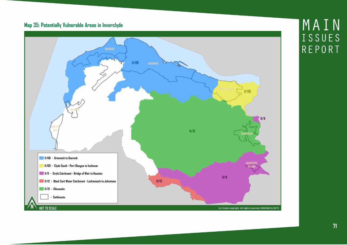
7171
Map 35: Potentially Vulnerable Areas in Inverclyde

72
A CONNECTED INVERCLYDE

737373
ISSUE 23 PROMOTING SUSTAINABLETRANSPORT AND ACTIVE TRAVEL
INTRODUCTION
Inverclyde is well served in terms of transport, with the A8 and
A78 trunk roads running through the area, as well as two train
lines with fourteen stations, all of which connect Inverclyde
with the rest of the Glasgow city-region and beyond. A number
of bus companies also operate across Inverclyde, while four
ferry services provide connections to various locations in Argyll
and Bute. Inverclyde is also connected by a comprehensive
core path network and National Cycle Network routes NCN75
and NCN 753, which provide active travel connections to
Renfrewshire and Glasgow.
Transport is critical to the prosperity and sustainability of our
communities. Economic activity and growth relies on a
transport network that enables people and goods to move
efficiently around Inverclyde, Scotland and to international
markets. At the same time, the need to tackle climate change
by cutting transport emissions requires an approach which
reduces the need to travel by car and prioritises sustainable
travel modes.
Planning can improve connectivity and promote sustainable
travel by locating new development near active travel and
public transport networks, thereby offering people the choice
of walking, cycling or using public transport to reach their place
of work and local services. In support of this, Scottish Planning
Policy directs planning authorities to map active travel
networks in their Local Development Plans. It is also important
to identify where additional transport infrastructure is needed
to support new development and ensure that developers
contribute toward its provision. Supporting new transport
technologies, such as the provision of charging points for
electric vehicles, will also help reduce carbon emissions.
CURRENT LOCAL DEVELOPMENT PLAN
The settlement strategy directs new development to the
existing urban areas, which are well served by core paths, cycle
routes, public transport services and the strategic and local
road networks (see Map 36). The Plan policies support the
actions identified in the Local Transport Strategy (e.g. Baker
Street re-alignment and Kempock Street relief road), manage
the impact of new development on the strategic road network,
and promote a shift to more sustainable modes of transport, in
the order of walking, cycling and public transport. The Plan
also safeguards core paths and National Cycle Routes and
supports the development of the Inverclyde Coastal Route. It
is considered that this approach remains valid and should be
carried forward into the new Plan.

74
Map 36: Inverclyde Transport Network
ISSUE 23: Do you agree that the approach to sustainable transport and active travel set out in the current LocalDevelopment Plan remains valid and should be carried forward into the new Plan?

757575
ISSUE 24 KILMACOLM VILLAGE CENTREPARKING
Through the Call for Sites exercise, Kilmacolm Civic Trust has
identified long stay parking as an issue that causes difficulty
and frustration for residents, businesses and visitors to
Kilmacolm. The Civic Trust proposes the construction of up to
four long stay car parks in or near Kilmacolm village centre.
The proposed sites are identified in Map 37.
The Civic Trust’s submission notes that there is a clear need for
additional long stay car parking capacity in the village to meet
the needs of residents, those who work and study there during
the day, and those who commute to and from the village.
Policy TRA3 of the current Local Development Plan supports a
number of roads and parking actions identified in the Local
Transport Strategy 2011-2016. However, there are no actions
relating to the provision of additional long stay car parking in
Kilmacolm.
ISSUE 24: Do you think that there is a need for additional long stay car parking capacity in Kilmacolm? If yes,which of the proposed sites are suitable and why? Do you have an alternative approach to suggest?
Map 37: Locations Suggested by Kilmacolm Civic Trustfor New Car Parks

76
ISSUE 25 DIGITAL CONNECTIVITY
INTRODUCTION
Inverclyde has good digital connectivity with 4G mobile and
superfast broadband coverage available across the majority
of the area. This is of benefit to the economy and social
networks of the area, and contributes towards it being an
attractive place to live and invest. Good digital connectivity
allows businesses to reach their markets and people to keep
in touch and work flexibly wherever they are.
Scottish Planning Policy states that planning has an important
role to play in strengthening digital communications capacity
and coverage across Scotland and that it should support:
• development which helps the commitment to
world-class digital connectivity;
• networks evolving to respond to technology
improvements and new services;
• the inclusion of digital infrastructure in new
developments; and
• infrastructure provision which is sited and designed to
keep environmental impacts to a minimum.
CURRENT LOCAL DEVELOPMENT PLAN
The current Local Development Plan includes a policy for the
assessment of communications infrastructure, which is largely
concerned with the impact of the infrastructure on the
environment. Given the importance of digital communications
to businesses and residents, it is considered that this policy could
be more positive.
ISSUE 25: Do you agree that the approach to communications infrastructure set out in the Local DevelopmentPlan should be more positive?
Antenna, Flatterton Farm, by Greenock

777777
DEVELOPMENT OPPORTUNITY REVIEW

78
Through the pre-Main Issues Report ‘Call for Sites’ exercise, a total of 53 sites were suggested to the Council as having potential for
development, mostly for housing. The Council has assessed all of these sites and the outcome of this is set out in the Call for Sites
Assessment background report. Based on this assessment the Council’s preferred use for the suggested sites is set out in Table 5
below.
During preparation of the Main Issues Report, the opportunity has also been taken to assess the continuing appropriateness of the
development opportunities identified in the current Local Development Plan. Whilst many of these opportunities have now been
successfully developed, others have had no developer interest shown in them for a long time, and their continuing identification
as a development opportunity causes uncertainty for the surrounding community. The outcome of this assessment is set out in the
Development Opportunity Review background report, and the preferred future for these sites is set out in Table 6.
Since the current Local Development Plan was prepared a number of new housing sites have come forward through planning
permission or other means. It may be appropriate to include some of these sites in the new Local Development Plan and the
conclusion of this assessment is set out in Table 7.
ISSUE 26: Do you agree with the preferred use for the suggested, existing and new development opportunity sitesset out in Tables 5, 6 & 7?
ISSUE 26 DEVELOPMENT OPPORTUNITY REVIEW

797979
Table 5: Sites suggested for development through ‘Call for Sites’ exercise
Ref
001
002
003
004
005
006
007
008
009
010
011
012
013
014
015
Site
Carsemeadow
North Denniston
Knapps Loch
Land behind former
police station
Smithy Brae 1
Smithy Brae 2
Gillburn Road
Tathieknowe
Police Station Field
ARP Field
West Glen Road
Migdale, Finlaystone Road
Port Glasgow Road
Planetreeyetts
West of Quarry Drive
Location
Quarriers Village
Kilmacolm
Kilmacolm
Kilmacolm
Kilmacolm
Kilmacolm
Kilmacolm
Kilmacolm
Kilmacolm
Kilmacolm
Kilmacolm
Kilmacolm
Kilmacolm
Kilmacolm
Kilmacolm
Current Local
Plan zoning
Green Belt
Green Belt
Green Belt
Green Belt
Residential
Area
Residential
Area
Residential
Area
Green Belt
Green Belt
Green Belt
Green Belt
Green Belt
Green Belt
Green Belt
Green Belt
Suggested use
Residential Development
Residential Development
Residential Development
Car Park
Car Park
Car Park
Car Park
Residential Development
Residential Development
Residential Development
Residential Development
Residential Development
Residential Development
Residential Development
Residential Development
Preferred use in New Local
Development Plan
See Issue 10
See Issue 10
See Issue 10
See Issue 24
See Issue 24
See Issue 24
See Issue 24
See issue 10
See Issue 10
See Issue 10
See issue 10
See Issue 10
See Issue 10
See Issue 10
See Issue 10

80
Ref
016
017
018
019
020
021
022
023
024
025
Site
Stables Wood
Craigmarloch 1
Craigmarloch 2
Dubbs Road
Parkhill Farm
Parkhill
High Auchenleck Farm
Port Glasgow Industrial
Estate (South)
Port Glasgow Industrial
Estate (North)
Barr’s Brae (South)
Location
Kilmacolm
Kilmacolm
Kilmacolm
Port Glasgow
Port Glasgow
Port Glasgow
Port Glasgow
Port Glasgow
Port Glasgow
Port Glasgow
Current Local
Plan zoning
Green Belt
Green Belt
Green Belt
Residential
Area
Green Belt
Residential
Development
Opportunity /
Green Belt
Green Belt
Business and
Industrial
Development
Opportunity/
Business and
Industrial
Area
Business and
Industrial
Area
Residential
Development
Opportunity
Suggested use
Residential Development
Residential Development
Residential Development
Residential Development
Residential Development
Residential Development
Residential Development
Residential Development
Residential Development
Residential Development
Preferred use in New Local
Development Plan
See Issue 10
See Issue 10
See Issue 10
See Issue 11
See Issue 11
See Issue 11
See Issue 11
See Issue 8
See Issue 8
See Issue 11
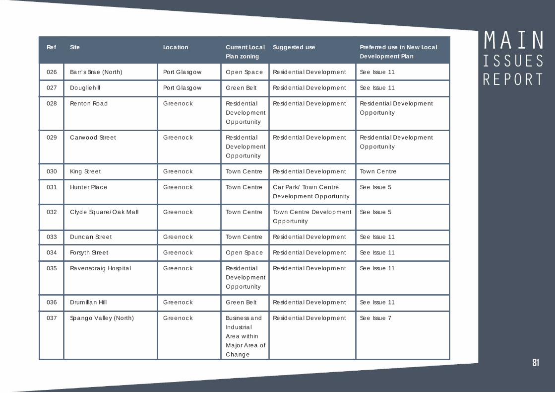
818181
Ref
026
027
028
029
030
031
032
033
034
035
036
037
Site
Barr’s Brae (North)
Dougliehill
Renton Road
Carwood Street
King Street
Hunter Place
Clyde Square/Oak Mall
Duncan Street
Forsyth Street
Ravenscraig Hospital
Drumillan Hill
Spango Valley (North)
Location
Port Glasgow
Port Glasgow
Greenock
Greenock
Greenock
Greenock
Greenock
Greenock
Greenock
Greenock
Greenock
Greenock
Current Local
Plan zoning
Open Space
Green Belt
Residential
Development
Opportunity
Residential
Development
Opportunity
Town Centre
Town Centre
Town Centre
Town Centre
Open Space
Residential
Development
Opportunity
Green Belt
Business and
Industrial
Area within
Major Area of
Change
Suggested use
Residential Development
Residential Development
Residential Development
Residential Development
Residential Development
Car Park/ Town Centre
Development Opportunity
Town Centre Development
Opportunity
Residential Development
Residential Development
Residential Development
Residential Development
Residential Development
Preferred use in New Local
Development Plan
See Issue 11
See Issue 11
Residential Development
Opportunity
Residential Development
Opportunity
Town Centre
See Issue 5
See Issue 5
See Issue 11
See Issue 11
See Issue 11
See Issue 11
See Issue 7

82
Ref
038
039
040
041
042
043
044
045
046
047
048
Site
Spango Valley (South)
Kirn Drive
Faulds Park Road
The Glebe
Langhouse Road
Langhouse Road/ Millhouse
Road
Kip Marina
Berfern
Inverkip Power Station
Misty Law, West Glen Road
Ratho/McDougall Street
Location
Greenock
Gourock
Gourock
Inverkip
Inverkip
Inverkip
Inverkip
Inverkip
Wemyss Bay
Kilmacolm
Greenock
Current Local
Plan zoning
Major Area of
Change
Residential
Area/ Green
Belt
Residential
Area
Residential
Development
Opportunity/
Open Space
Green Belt
Green Belt
Green Belt
Green Belt
Major Area of
Change
Green Belt
Business and
Industrial
Area
Suggested use
Residential Development
Residential Development
Residential Development
Residential Development
Residential Development
Residential Development
Residential Development
Residential Development
Residential Development
Residential Development
Residential Development
Preferred use in New Local
Development Plan
See Issue 7
See Issue 11
See Issue 11
See Issue 11
See Issue 11
See issue 11
See Issue 11
See Issue 11
See Issue 2
See issue 11
See issue 11

838383
Ref
049
050
051
052
053
Site
Lyle Road
Former Holy Cross School,
Lyle Road
Auchneagh Road
Former Sacred Heart School,
Westmorland Road
Cumberland Walk
Location
Greenock
Greenock
Greenock
Greenock
Greenock
Current Local
Plan zoning
Open Space
Open Space
Residential
Area
Residential
Area
Town Centre/
Retail
Development
Opportunity
Suggested use
Residential Development
Residential Development
Residential Development
Residential Development
Residential Development
Preferred use in New Local
Development Plan
See Issue 11
See Issue 11
See Issue 11
See Issue 11
See issue 11

84
Table 6: Review of Development Opportunities in current Local Development Plan (2014)
Ref
e1
e2
e3
e4
e5
e6
e7
e8
e9
e10
Site
Cartsburn (Landward W)
Cartsburn (Riverside)
Cartsburn (Landward E)
Riverside Business Park
Riverside Business Park
Pottery Street (N)/Inchgreen
Larkfield Industrial Estate
Baker Street/Ingleston
Kelburn Business Park
Former Inverkip PowerStation
Location
Greenock
Greenock
Greenock
Greenock
Greenock
Greenock
Greenock
Greenock
Port Glasgow
By Wemyss Bay
Current Local Plan zoning
Business and Industrial DevelopmentOpportunity (Class 4, 5 and 6)
Business and Industrial DevelopmentOpportunity (Class 4, 5 and 6)
Business and Industrial DevelopmentOpportunity (Class 4, 5 and 6)
Business and Industrial DevelopmentOpportunity (Class 4, 5 and 6)
Business and Industrial DevelopmentOpportunity (Class 4, 5 and 6)
Business and Industrial DevelopmentOpportunity (Class 4, 5 and 6)
Business and Industrial DevelopmentOpportunity (Class 4, 5 and 6)
Business and Industrial DevelopmentOpportunity (Class 4, 5 and 6)
Business and Industrial DevelopmentOpportunity (Class 4, 5 and 6)
Business and Industrial DevelopmentOpportunity (Class 4, 5 and 6)
Preferred use in New Local
Development Plan
Business and IndustrialDevelopment Opportunity
Business and IndustrialDevelopment Opportunity
Business and IndustrialDevelopment Opportunity
Developed - delete as aDevelopment Opportunity
Developed - delete as aDevelopment Opportunity
Business and IndustrialDevelopment Opportunity
Extend boundary to includevacant site to the south.Identify new combined areaas a Business and IndustrialDevelopment Opportunity
Business and IndustrialDevelopment Opportunity
Identify the undevelopedarea as a Business andIndustrial DevelopmentOpportunity
Business and IndustrialDevelopment Opportunity
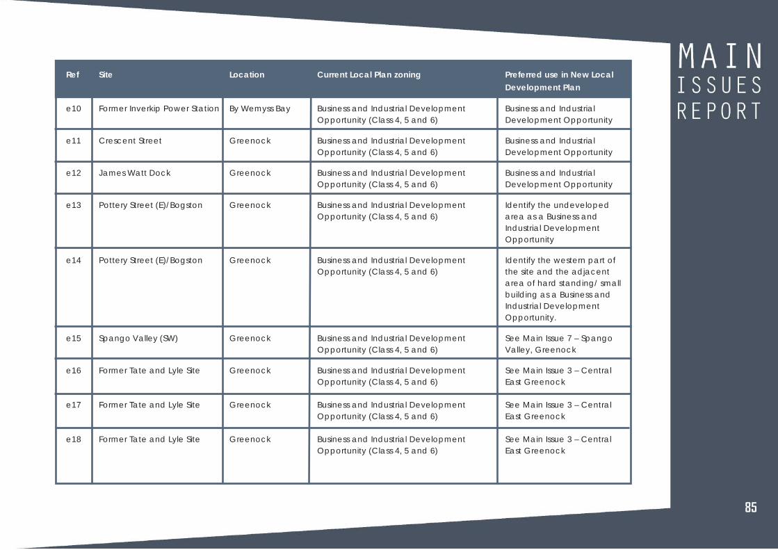
858585
Ref
e10
e11
e12
e13
e14
e15
e16
e17
e18
Site
Former Inverkip Power Station
Crescent Street
James Watt Dock
Pottery Street (E)/Bogston
Pottery Street (E)/Bogston
Spango Valley (SW)
Former Tate and Lyle Site
Former Tate and Lyle Site
Former Tate and Lyle Site
Location
By Wemyss Bay
Greenock
Greenock
Greenock
Greenock
Greenock
Greenock
Greenock
Greenock
Current Local Plan zoning
Business and Industrial DevelopmentOpportunity (Class 4, 5 and 6)
Business and Industrial DevelopmentOpportunity (Class 4, 5 and 6)
Business and Industrial DevelopmentOpportunity (Class 4, 5 and 6)
Business and Industrial DevelopmentOpportunity (Class 4, 5 and 6)
Business and Industrial DevelopmentOpportunity (Class 4, 5 and 6)
Business and Industrial DevelopmentOpportunity (Class 4, 5 and 6)
Business and Industrial DevelopmentOpportunity (Class 4, 5 and 6)
Business and Industrial DevelopmentOpportunity (Class 4, 5 and 6)
Business and Industrial DevelopmentOpportunity (Class 4, 5 and 6)
Preferred use in New Local
Development Plan
Business and IndustrialDevelopment Opportunity
Business and IndustrialDevelopment Opportunity
Business and IndustrialDevelopment Opportunity
Identify the undevelopedarea as a Business andIndustrial DevelopmentOpportunity
Identify the western part ofthe site and the adjacentarea of hard standing/ smallbuilding as a Business andIndustrial DevelopmentOpportunity.
See Main Issue 7 – SpangoValley, Greenock
See Main Issue 3 – CentralEast Greenock
See Main Issue 3 – CentralEast Greenock
See Main Issue 3 – CentralEast Greenock

86
Ref
e19
e20
e21
e22
e23
e24
t1
t2
t3
r1
r2
r3
Site
Regent Street
John Street
Sinclair Street
Port Glasgow IndustrialEstate (West)
Port Glasgow IE (South)
Inner Lower Port Glasgow
Gourock Bay
The Harbours
James Watt Dock
Former Broadfield Hospital
Arran Ave, Park Farm
Woodhall (Phase 2)
Location
Greenock
Greenock
Greenock
Port Glasgow
Port Glasgow
Port Glasgow
Gourock
Greenock
Greenock
Port Glasgow
Port Glasgow
Port Glasgow
Current Local Plan zoning
Business and Industrial DevelopmentOpportunity (Class 4, 5 and 6)
Business and Industrial DevelopmentOpportunity (Class 4, 5 and 6)
Business and Industrial DevelopmentOpportunity (Class 4, 5 and 6)
Business and Industrial DevelopmentOpportunity (Class 4, 5 and 6)
Business and Industrial DevelopmentOpportunity (Class 4, 5 and 6)
Business and Industrial DevelopmentOpportunity (Class 4, 5 and 6)
Tourism Opportunity
Tourism Opportunity
Tourism Opportunity
Residential Development Opportunity
Residential Development Opportunity
Residential Development Opportunity
Preferred use in New Local
Development Plan
Development Option Site
Residential Area
Business and IndustrialDevelopment Opportunity
Business and IndustrialDevelopment Opportunity
Green Belt. See Main Issue 8 –Port Glasgow Industrial Estate
Identify eastern site as aBusiness and IndustrialDevelopment Opportunity
Tourism DevelopmentOpportunity
Tourism DevelopmentOpportunity
Tourism DevelopmentOpportunity
Residential DevelopmentOpportunity
Green Belt
Residential DevelopmentOpportunity
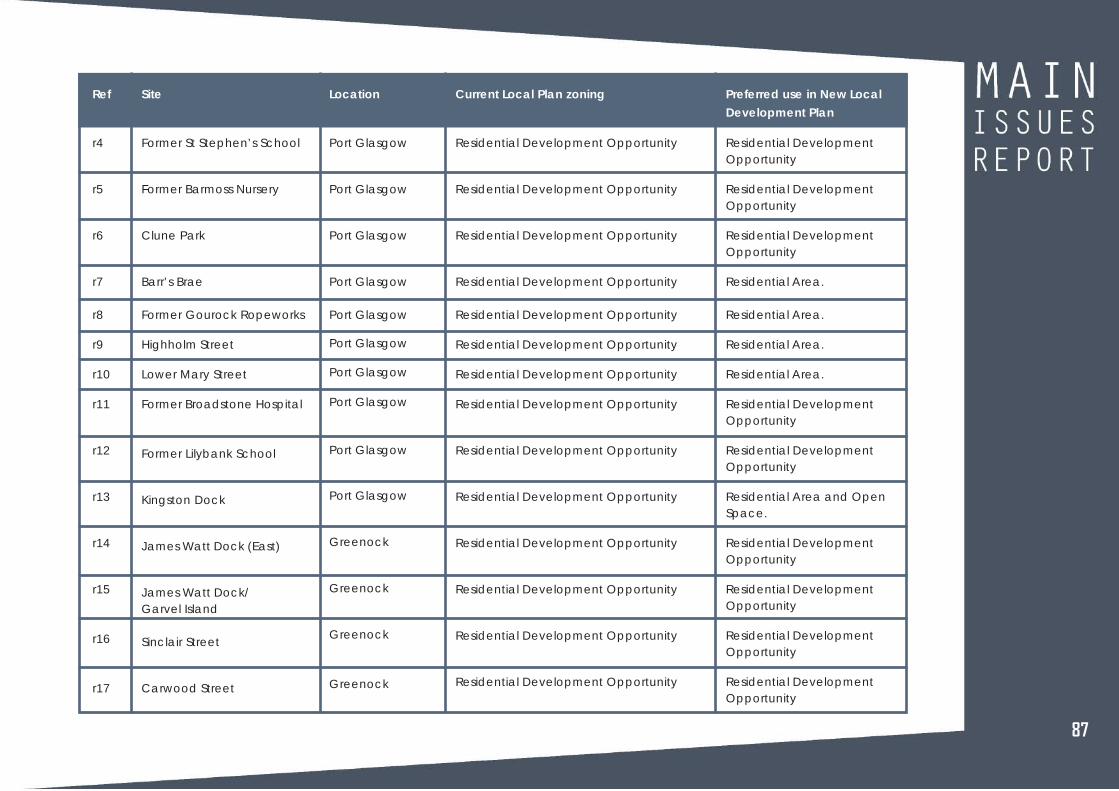
878787
Ref
r4
r5
r6
r7
r8
r9
r10
r11
r12
r13
r14
r15
r16
r17
Site
Former St Stephen’s School
Former Barmoss Nursery
Clune Park
Barr’s Brae
Former Gourock Ropeworks
Highholm Street
Lower Mary Street
Former Broadstone Hospital
Former Lilybank School
Kingston Dock
James Watt Dock (East)
James Watt Dock/Garvel Island
Sinclair Street
Carwood Street
Location
Port Glasgow
Port Glasgow
Port Glasgow
Port Glasgow
Port Glasgow
Port Glasgow
Port Glasgow
Port Glasgow
Port Glasgow
Port Glasgow
Greenock
Greenock
Greenock
Greenock
Current Local Plan zoning
Residential Development Opportunity
Residential Development Opportunity
Residential Development Opportunity
Residential Development Opportunity
Residential Development Opportunity
Residential Development Opportunity
Residential Development Opportunity
Residential Development Opportunity
Residential Development Opportunity
Residential Development Opportunity
Residential Development Opportunity
Residential Development Opportunity
Residential Development Opportunity
Residential Development Opportunity
Preferred use in New Local
Development Plan
Residential DevelopmentOpportunity
Residential DevelopmentOpportunity
Residential DevelopmentOpportunity
Residential Area.
Residential Area.
Residential Area.
Residential Area.
Residential DevelopmentOpportunity
Residential DevelopmentOpportunity
Residential Area and OpenSpace.
Residential DevelopmentOpportunity
Residential DevelopmentOpportunity
Residential DevelopmentOpportunity
Residential DevelopmentOpportunity

88
Ref
r18
r19
r20
r21
r22
r23
r24
r25
r26
r27
r28
r29
r30
Site
Garvald Street
Former King’s Glen school
Luss Avenue/Renton Road
Kilmacolm Road
Strone (brownfield)
Strone (greenfield)
Wellington Park
Killochend Drive
Former Tate and Lyle (SE)
Former Tate and Lyle (NE)
Drumfrochar Road
Broomhill
Former Wellington School
Location
Greenock
Greenock
Greenock
Greenock
Greenock
Greenock
Greenock
Greenock
Greenock
Greenock
Greenock
Greenock
Greenock
Current Local Plan zoning
Residential Development Opportunity
Residential Development Opportunity
Residential Development Opportunity
Residential Development Opportunity
Residential Development Opportunity
Residential Development Opportunity
Residential Development Opportunity
Residential Development Opportunity
Residential Development Opportunity
Residential Development Opportunity
Residential Development Opportunity
Residential Development Opportunity
Residential Development Opportunity
Preferred use in New Local
Development Plan
Residential DevelopmentOpportunity
Residential developmentopportunity, with partidentified for Children’sCentre.
Residential DevelopmentOpportunity
Residential Area
Residential DevelopmentOpportunity. See Main Issue 3– Central East Greenock
Green Belt
See Main Issue 3 - CentralEast Greenock
Green Belt
See Main Issue 3 - CentralEast Greenock
See Main Issue 3 - CentralEast Greenock
Residential DevelopmentOpportunity
Residential Area.
Residential Area orCommunity Opportunity

898989
Ref
r31
r32
r33
r34
r35
r36
r37
r38
r39
r40
r41
r42
r43
Site
Former Highlander’s Academy
Regent Street
Victoria/East India Harbour
West Blackhall Street
Argyle Street
Houston Street
Union Street
Former Greenock Academy
Peat Road/Hole Farm
Ravenscraig Hospital
Earnhill Road (Phase 2)
Former Ravenscraig School
Former St Gabriel’s School
Location
Greenock
Greenock
Greenock
Greenock
Greenock
Greenock
Greenock
Greenock
Greenock
Greenock
Greenock
Greenock
Greenock
Current Local Plan zoning
Residential Development Opportunity
Residential Development Opportunity
Residential Development Opportunity
Residential Development Opportunity
Residential Development Opportunity
Residential Development Opportunity
Residential Development Opportunity
Residential Development Opportunity
Residential Development Opportunity
Residential Development Opportunity
Residential Development Opportunity
Residential Development Opportunity
Residential Development Opportunity
Preferred use in New Local
Development Plan
Residential DevelopmentOpportunity
Development Option site.
Residential DevelopmentOpportunity
Town Centre
Residential DevelopmentOpportunity
Residential DevelopmentOpportunity
Residential DevelopmentOpportunity
Residential DevelopmentOpportunity
Residential DevelopmentOpportunity with amendedboundary
Residential DevelopmentOpportunity, with expandedboundaries for developablearea
Residential Area.
Residential DevelopmentOpportunity
Residential DevelopmentOpportunity

90
Ref
r44
r45
r46
r47
r48
r49
r50
r51
r52
r53
r54
r55
r56
r57
Site
Valley Park, Spango Valley
Cove Road (Tarbet Street)
Riverside Gardens, GourockBay
Pierhead, Shore Street
Shore Street
Kempock House, Kirn Drive
Cloch Road (Phases 1 & 2)
Levan Farm (Phase 3)
Bridgend
The Glebe
Kip Marina
Hill Farm
Former Inverkip PowerStation
The Meadows
Location
Greenock
Gourock
Gourock
Gourock
Gourock
Gourock
Gourock
Gourock
Inverkip
Inverkip
Inverkip
Inverkip
Wemyss Bay
Wemyss Bay
Current Local Plan zoning
Residential Development Opportunity
Residential Development Opportunity
Residential Development Opportunity
Residential Development Opportunity
Residential Development Opportunity
Residential Development Opportunity
Residential Development Opportunity
Residential Development Opportunity
Residential Development Opportunity
Residential Development Opportunity
Residential Development Opportunity
Residential Development Opportunity
Residential Development Opportunity
Residential Development Opportunity
Preferred use in New Local
Development Plan
See Main Issue 7 – SpangoValley, Greenock
Residential DevelopmentOpportunity
Residential DevelopmentOpportunity
Town Centre DevelopmentOpportunity
Residential DevelopmentOpportunity
Residential DevelopmentOpportunity
Residential Area.
Residential DevelopmentOpportunity
Residential DevelopmentOpportunity
Residential DevelopmentOpportunity
Residential Area
Residential Area
Residential DevelopmentOpportunity
Residential Area

919191
Ref
r58
r59
r60
r61
r62
r63
r64
c1
c2
c3
c4
c5
c6
Site
Leperstone Avenue
Smithy Brae
Whitelea Road
Lochwinnoch Road
Former Balrossie School
Former Quarry, Port GlasgowRoad
Woodside Care Home
Former Inverkip Power Station
Off A78(T)
Spango Valley
Inverkip Road
Rankin Park
Broomhill
Location
Kilmacolm
Kilmacolm
Kilmacolm
Kilmacolm
Kilmacolm
Kilmacolm
Quarriers Village
Wemyss Bay
Inverkip
Greenock
Greenock
Greenock
Greenock
Current Local Plan zoning
Residential Development Opportunity
Residential Development Opportunity
Residential Development Opportunity
Residential Development Opportunity
Residential Development Opportunity
Residential Development Opportunity
Residential Development Opportunity
Leisure Use Opportunity
Community Facility Opportunity
Leisure Opportunity
New Prison
Sports Facility Opportunity
Community Facility Opportunity
Preferred use in New Local
Development Plan
Residential DevelopmentOpportunity
Residential DevelopmentOpportunity
Residential DevelopmentOpportunity
Green Belt
Residential DevelopmentOpportunity
Residential Area
Residential DevelopmentOpportunity with amendedboundaries
Leisure DevelopmentOpportunity
Residential Area
See Main Issue 7 – SpangoValley, Greenock
Community DevelopmentOpportunity
Open Space
Residential Area

92
Ref
c7
c8
c9
c10
tc1
tc2
tc3
tc4
tc5
tc6
tc7
tc8
tc9
Site
Sinclair Street
Gibshill Road
Woodhall NewNeighbourhood (Phase 2)
Kilmacolm Road
Ker Street
25 West Stewart Street
4 West Stewart Street
15 Nelson Street
Pierhead, Shore Street
53/55 Shore Street
Waterfront (West)
19 Bay Street
Kip Park, Main Street
Location
Greenock
Greenock
Port Glasgow
Port Glasgow
Greenock
Greenock
Greenock
Greenock
Gourock
Gourock
Port Glasgow
Port Glasgow
Inverkip
Current Local Plan zoning
Leisure Opportunity
Community Facility Opportunity
Community Facility Opportunity
Joint School Campus
Town Centre/Retail DevelopmentOpportunity
Town Centre/Retail DevelopmentOpportunity
Town Centre/Retail DevelopmentOpportunity
Town Centre/Retail DevelopmentOpportunity
Town Centre/Retail DevelopmentOpportunity
Town Centre/Retail DevelopmentOpportunity
Town Centre/Retail DevelopmentOpportunity
Town Centre/Retail DevelopmentOpportunity
Town Centre/Retail DevelopmentOpportunity
Preferred use in New Local
Development Plan
Business and IndustrialDevelopment Opportunity
Residential Area
Community DevelopmentOpportunity
Residential Area
Town Centre
Town Centre/RetailDevelopment Opportunitywith expanded boundaries.
Town Centre/RetailDevelopment Opportunity
Town Centre/RetailDevelopment Opportunity
Town Centre/RetailDevelopment Opportunity
Town Centre/RetailDevelopment Opportunity
Town Centre
Town Centre
Town Centre/RetailDevelopment Opportunity

939393
Ref
tc10
tc11
tc12
tc13
tc14
Site
Cumberland Walk
The Harbours
Former Inverkip Power Station
Spango Valley (Valley Park)
James Watt Dock/GarvelIsland
Location
Greenock
Greenock
Wemyss Bay
Greenock
Greenock
Current Local Plan zoning
Town Centre/Retail DevelopmentOpportunity
Town Centre/Retail DevelopmentOpportunity
Town Centre/Retail DevelopmentOpportunity
Town Centre/Retail DevelopmentOpportunity
Town Centre/Retail DevelopmentOpportunity
Preferred use in New Local
Development Plan
Town Centre/RetailDevelopment Opportunity,including residential element
Major Area of Change
Town Centre/RetailDevelopment Opportunity
Town Centre/RetailDevelopment Opportunity –See Main Issue 7 – SpangoValley, Greenock
Town Centre/RetailDevelopment Opportunity
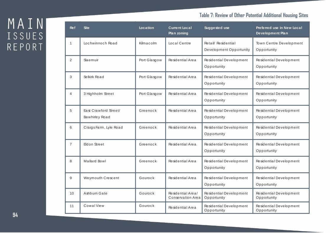
94
Ref
1
2
3
4
5
6
7
8
9
10
11
Site
Lochwinnoch Road
Slaemuir
Selkirk Road
3 Highholm Street
East Crawford Street/
Bawhirley Road
Craigs Farm, Lyle Road
Eldon Street
Mallard Bowl
Weymouth Crescent
Ashburn Gate
Cowal View
Location
Kilmacolm
Port Glasgow
Port Glasgow
Port Glasgow
Greenock
Greenock
Greenock
Greenock
Gourock
Gourock
Gourock
Current Local
Plan zoning
Local Centre
Residential Area
Residential Area
Residential Area
Residential Area
Residential Area
Residential Area
Residential Area
Residential Area
Residential Area/Conservation Area
Residential Area
Suggested use
Retail/ Residential
Development Opportunity
Residential Development
Opportunity
Residential Development
Opportunity
Residential Development
Opportunity
Residential Development
Opportunity
Residential Development
Opportunity
Residential Development
Opportunity
Residential Development
Opportunity
Residential Development
Opportunity
Residential DevelopmentOpportunity
Residential DevelopmentOpportunity
Preferred use in New Local
Development Plan
Town Centre Development
Opportunity
Residential Development
Opportunity
Residential Development
Opportunity
Residential Development
Opportunity
Residential Development
Opportunity
Residential Development
Opportunity
Residential Development
Opportunity
Residential Development
Opportunity
Residential Development
Opportunity
Residential DevelopmentOpportunity
Residential DevelopmentOpportunity
Table 7: Review of Other Potential Additional Housing Sites

Regeneration and PlanningInverclyde CouncilMunicipal BuildingsClyde SquareGreenockPA15 1LY
Telephone:Telephone: 01475 717171
E-mail: [email protected]
Web: www.inverclyde.gov.uk/newldp