minutes - moorabool.vic.gov.au dac... · human rights issues. in particular, whether the scope of...
TRANSCRIPT
MINUTES SECTION 86 DEVELOPMENT ASSESSMENT
COMMITTEE MEETING
Wednesday 12 July, 2017 Council Chambers,
15 Stead Street, Ballan 4.00pm
MEETING OPENING
Councillor Pat Toohey as the Chair welcomed all and opened the meeting at 4.08pm.
ATTENDANCE
Cr. Pat Toohey (Chair) Councillor – Woodlands Moorabool Ward
Cr. Tonia Dudzik (Deputy Mayor) Councillor – East Moorabool Ward
Cr. John Keogh Councillor – East Moorabool Ward
Cr. Paul Tatchell Councillor – Central Moorabool Ward
Mr. Satwinder Sandhu General Manager Growth & Development
Mr Mark Lovell Senior Statutory Planner
Ms. Judy Lotz Minute taker
2. CONFIRMATION OF PREVIOUS MEETING MINUTESResolution:
Moved: Cr. Tatchell Seconded: Cr. Dudzik
That the Minutes of the Section 86 Development Assessment Committee for 14 June, 2017 be confirmed as a true and correct record.
CARRIED
3. CONFLICT OF INTEREST
No conflicts of interest were declared at the meeting.
4. GROWTH & DEVELOPMENT REPORTS
4.1 Planning Permit Application PA2016-212; Development of five (5) dwellings; Lot 22 on PS518914N otherwise known as 4 Ross Street Darley.
Victoria Mack Page 3 Resolution
4.2 Planning Permit Application 2016 194; Two (2) Lot Re-subdivision and Reduction to the Standard Car Parking Rate for the Existing Hotel at Lot 1 on TP99725J known as 151 Inglis Street, Ballan.
Mark Lovell Page 22 Resolution
1

PRESENTATIONS/DEPUTATIONS
List of Persons making Presentations/Deputations to a planning item listed on the agenda: Individuals seeking to make a presentation to the Council on a planning item listed on the agenda for consideration at the meeting will be heard by the Council immediately preceding consideration of the Council Officer’s report on the planning item.
Item No Description Name Applicant/Objector 4.2 Planning Permit Application 2016194;
Two (2) Lot Re-Subdivision and Reduction to the Standard Car parking Rate for the Existing Hotel at Lot 1 on TP99725J know as 151 Inglis Street Ballan.
Joc O’Connor Owner
2

GROWTH & DEVELOPMENT REPORTS
Item 4.1 Planning Permit Application PA202016 212 Planning Permit Application PA2016-212; Development of five (5) dwellings; Lot 22 on PS518914N otherwise known as 4 Ross Street Darley.
Application Summary:
Permit No: PA2016212
Lodgement Date: 29 August 2016
Planning Officer: Victoria Mack
Address of the land: 4 Ross Street, Darley VIC 3340
Proposal: Development of five (5) dwellings
Lot size: 1200sqm
Why is a permit required Two or more dwellings in the General Residential Zone, Schedule 1
Public Consultation:
Was the application advertised? Notices on site: Notice in Moorabool Newspaper: Number of Objections: Consultation meeting:
Yes Yes No One No
Policy Implications:
Key Result Area Enhanced Natural and Built Environment.
Objective Effective and efficient land use planning and building control.
Strategy Implement high quality, responsive, and efficient processing systems for planning and building applications. Ensure that development is sustainable, resilient to change and respects the existing character.
3

Victorian Charter of Human Rights and Responsibilities Act 2006
In developing this report to Council, the officer considered whether the subject matter raised any human rights issues. In particular, whether the scope of any human right established by the Victorian Charter of Human Rights and Responsibilities is in any way limited restricted or interfered with by the recommendations contained in the report. It is considered that the subject matter does not raise any human rights issues.
Officer's Declaration of Conflict of Interests
Under section 80C of the Local Government Act 1989 (as amended), officers providing advice to Council must disclose any interests, including the type of interest. Manager – Rob Fillisch In providing this advice to Council as the Manager, I have no interests to disclose in this report. Author – Victoria Mack In providing this advice to Council as the Author, I have no interests to disclose in this report.
Executive Summary:
Application Referred? Yes
Any issues raised in referral responses? No. However, Infrastructure has subsequently responded to the objector’s concerns about traffic and parking congestion in Ross Street.
Preliminary Concerns? Compliance with Rescode Standards. Density of dwellings. It was suggested that the application was reduced to 4 dwellings but the applicant was reluctant to reduce the number of dwellings.
Any discussions with applicant regarding concerns
Yes
Any changes made to the application since being lodged?
Plans amended to address Rescode Standards
VCAT history? Nil
Previous applications for the site?
Nil
General summary
The application is for the development of five (5) dwellings on the lot. The original plans were modified to meet Rescode standards and they generally accord with all Rescode standards except B15 where the plans will need to be amended to achieve compliance. This standard relates to the distance of habitable room windows from the shared access way or car parks of other dwellings and residential buildings which should be located at least 1.5 metres from the windows of habitable rooms. This setback may be reduced to 1 metre where there is a fence at least 1.5 metres high or where window sills are at least 1.4 metres above the access way. The current proposal shows that the distance would be 600mm. The location, height or glazing of these windows needs to be modified.
4

The proposal is in keeping with the character of surrounding dwellings which includes equally compact double or single storey medium density town houses on small lots with shared access ways to rear dwellings, no front fences and limited landscaping.
Summary Recommendation:
That, having considered all matters as prescribed by the Planning and Environment Act, Council issues a Notice of Decision to Grant a Planning permit for the Development of five (5) dwellings on Lot 22 on PS518914N otherwise known as 4 Ross Street Darley.
Public Notice The application was notified to adjoining and surrounding landowners. One objection was received. Summary of Objections The objection received is detailed below with officer’s comments accompanying them:
Objection Any relevant requirements
Vehicle congestion in the street is increasing due to the many multi-dwelling developments either completed or under construction in Ross Street. Congestion is exacerbated by on-street parking and illegal parking on the nature strips, making it difficult for residents to navigate the street.
Clause 56.06-8, Table C1 – Level 2 Access Street
Officer’s response – Council’s Infrastructure Department has advised that Ross Street has a minimum carriageway cross-section width of 7.3 metres, satisfying Clause 56.06-8, Table C1 – Level 2 Access Street. In the Infrastructure Design Manual (IDM), this is adopted as a minimum standard for residential streets. It is intended to provide two parking lanes of 2.1m each and one traffic lane of 3.1m, sufficient for emergency and service vehicle access. The proposed layout (in this application) provides the required amount of off-street parking for a development of this scale, Planning Scheme Reference Clause 52.06-5 Table 1. Council’s Infrastructure Department has also advised that on-street car parking is controlled by traffic regulations, Section 12 – Road Rules 2009. It is noted that kerbside parking of vehicles is legal (however inconvenient), provided that the restrictions (distance from intersections, keeping clear of driveways, not blocking traffic, etc.) are adhered to. It is not legal to park on a nature strip.
The growing vehicle congestion and dwelling density will make it impossible to place rubbish bins out for collection.
Clause 56.06-8, Table C1 – Level 2 Access Street
Officer’s response - Council’s Infrastructure Department has advised that there is adequate room for on-street bin placement for collection.
The street is becoming dangerous for residents including children.
Officer’s response – The road network is provided for vehicular use and is considered appropriate according to the infrastructure design manual which considers the safety of all road users.
5

Objection Any relevant requirements
The street is becoming dangerous due to drivers trying to navigate the street.
Clause 56.06-8, Table C1 – Level 2 Access Street
Officer’s response – See Council’s Infrastructure Department’s response above. Motorists must drive safely in accordance with the Road Rules.
Background The original proposal did not comply with a number of Rescode standards. The applicant amended the plans to meet the standards. Proposal It is proposed to construct five (5) dwellings on the lot which has an area of 1200sqm. The dwellings would comprise:
Three two story dwellings at the front of the lot facing Ross Street; and
Two single storey dwellings at the rear of the lot accessed by a common property access way. The dwellings would have the following specifications: Dwelling 1: would be setback 5.4m from the street with a porch encroaching 1.2m into this setback. The ground floor would comprise an entrance including an open plan study and enclosed storage area, a powder room, an open plan kitchen, meals and living area including stairs to the upper floor, a rear courtyard with 42.49sqm of private open space with northerly orientation, and an attached single garage with a tandem car space in front of the garage. The upper floor would contain three bedrooms: the master bedroom with WIR; and the other two bedrooms with built in robes. There would be a bathroom and linen cupboard. Highlight windows or obscure glazing would be installed on the upper floor, where applicable, to prevent overlooking onto neighbouring properties. The dwelling would be constructed on the north side boundary for a length of 4.27m. The south side wall of dwelling 1 would be a common wall with dwelling 2 for 11m. Dwelling 2: would be setback 5.4m from the street with a porch encroaching 1.2m into this setback. The ground floor would comprise an entrance including an open plan study and enclosed storage area, a powder room, an open plan kitchen, meals and living area including stairs to the upper floor, a rear courtyard with 41.26sqm of private open space with northerly orientation, and an attached single garage with a tandem car space in front of the garage. The upper floor would contain three bedrooms: the master bedroom with WIR; and the other two bedrooms with built in robes. There would be a bathroom and linen cupboard. Highlight windows or obscure glazing would be installed on the upper floor, where applicable, to prevent overlooking onto neighbouring properties. The north side wall of dwelling 2 would be a common wall with dwelling 1 for 11m. Dwelling 2 would abut the common property on the south side setback 600mm from the common property access way. Dwelling 3: would be setback 5.04m from the street with a porch encroaching 0.9m into this setback. The ground floor would comprise an entrance into an open plan kitchen, meals and living area including stairs to the upper floor, a powder room, a laundry, and a rear courtyard with 31.32sqm
6

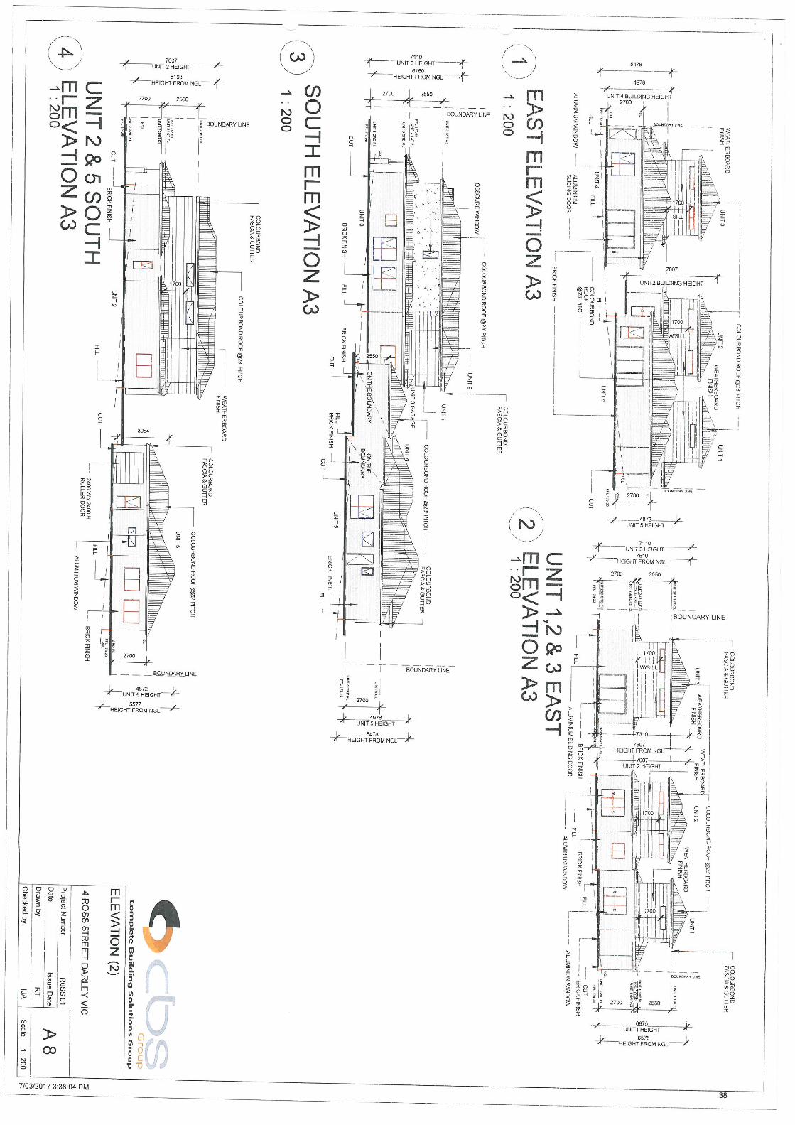
of private open space with northerly orientation. To the rear of this dwelling would be a two-car space garage with access from the common property driveway. The upper floor would contain three bedrooms: the master bedroom with WIR and ensuite; and the other two bedrooms with built in robes. There would be also be a bathroom. Highlight windows or obscure glazing would be installed on the upper floor, where applicable, to prevent overlooking onto neighbouring properties. The dwelling would abut the common property on the north side setback 600mm from the common property driveway. The dwelling would be setback 1.654m from the south side boundary. Dwelling 4: would be a single storey dwelling located to the rear of the front dwellings in the south-east corner of the site. The floor plan would comprise an entrance to an open plan kitchen, meals and living area with access to a rear courtyard with 48.52sqm of private open space with northerly orientation. A single garage would be attached to the dwelling. The dwelling would have two bedrooms with built in robes. There would be a bathroom and a laundry. The dwelling would have access from the common property driveway. The dwelling would be setback 1.057m from the south side boundary and 3m from the rear east side boundary. Dwelling 5: would be a single storey dwelling located to the rear of the front dwellings in the north-east corner of the site. The floor plan would comprise an entrance to an open plan kitchen, meals and living area with access to a rear courtyard with 68.27sqm of private open space with northerly orientation. A single garage would be attached to the dwelling. The dwelling would have two bedrooms with built in robes. There would be a bathroom, a laundry and a small study/lounge. The dwelling would have access from the common property driveway. The dwelling would be setback 1.093m from the north side boundary and 3m from the rear east side boundary. Plans of the dwellings area provide in Attachment 1. The dwellings would have the following details:
Ground floor area Upper Floor area Total floor area
Dwelling 1 105.48sqm 67.78sqm 173.26sqm
Dwelling 2 101.41sqm 65.74sqm 167.15sqm
Dwelling 3 116.25sqm 56.66sqm 172.91sqm
Dwelling 4 120.04sqm n/a 120.04sqm
Dwelling 5 129.31sqm N/A 129.31sqm
The site coverage and permeability are as follows:
Total site coverage Total permeability
47.69 % 52.31 %
Access and Parking A common property coloured permeable concrete driveway with a minimum width of 3.128m would service dwellings 3, 4 and 5. A visitor space would be included in the common property to the rear of the site. Site Description
7

The site is 1200sqm and is vacant and rectangular in shape. It is located on the east side of Ross Street approximately 40m from the intersection of Ross Street with Holts Lane to the south. Ross Street is an access street and until there is further development to the north the street ends at a small reserve. However, the street intersects with Fredrick Street which creates a ring road around the precinct. Fredrick Street is also accessed from Holts Lane. The aerial map below shows development and proposed subdivision in the surrounding area.
Immediate surrounds The Ross Street and Fredrick Street precinct is unique to Darley and is characterised by attached and semi-detached multi-unit and town house developments ranging in contemporary single and double built form. The precinct has a modified grid street layout with a one-sided footpath network. The streetscape is neat with minimal street tree plantings. Large lots of similar size to the subject have typically have been developed with 4 or 5 double storey dwellings on lots; or with multiple single storey units. Currently there are a number of multi-dwelling single and double storey developments under construction in the Ross and Fredrick Street precinct including nine single dwellings opposite the site to the west at 3-5 Ross Street. To the south of the site is a two-dwelling development and a single dwelling. To the north are 4 double storey town houses configured similarly to the development proposed in this application. To the east is vacant undeveloped land. Ross Street is located approximately 505m from the intersection of Holts Lane with Hallett’s Way. There is a bus stop at this corner that provides access to shopping and services in Bacchus Marsh and Darley, as well as a regular bus service to the Bacchus Marsh railway station.
8

Footpaths provide walking access to the bus stop. Otherwise the precinct is relatively car dependent. The precinct is elevated in the landscape with substantial views to the east across the Bacchus Marsh and Darley area. The land slopes down from the west side to the east. Locality Map The map below indicates the location of the subject site and the zoning of the surrounding area.
Planning Scheme Provisions Council is required to consider the Victoria Planning Provisions and give particular attention to the State Planning Policy Framework (SPPF), the Local Planning Policy Framework (LPPF) and the Municipal Strategic Statement (MSS). The relevant clauses are:
11 – Settlement.
11.05-2 – Melbourne’s hinterland areas.
11.06-1 – Planning for growth.
15.01-5 – Cultural identity and neighbourhood character.
16.01-1 – Integrated housing.
16.01-2 – Location of residential development.
16.01-4 – Housing diversity.
21.03-2 – Urban Growth Management.
21.03-3 – Residential Development.
21.03-4 – Landscape and neighbourhood Character.
21.07 – Bacchus Marsh.
9

The proposal generally complies with the relevant sections of the SPPF and LPPF. Zone General Residential Zone – Schedule 1 (GRZ1) The subject site is in the General Residential Zone, Schedule 1 (GRZ1), and the provisions of Clause 32.08 apply. The purpose of the zone is:
To implement the State Planning Policy Framework and the Local Planning Policy Framework, including the Municipal Strategic Statement and local planning policies.
To encourage development that respects the neighbourhood character of the area.
To implement neighbourhood character policy and adopted neighbourhood character guidelines.
To provide a diversity of housing types and moderate housing growth in locations offering good access to services and transport.
To allow educational, recreational, religious, community and a limited range of other nonresidential uses to serve local community needs in appropriate locations.
In accordance with Clause 32.08-6 of the Moorabool Planning Scheme a permit is required for the construction and extension of two or more dwellings on a lot. Pursuant to this clause the development must meet the requirements of Clause 55 (Two or More Dwellings on a Lot and Residential Buildings). Overall, the proposed development is considered to be consistent with the purpose and decision guidelines of the GRZ1 as discussed further in this report. Before deciding on an application to develop two or more dwellings on a lot, in addition to the decision guidelines in Clause 65, the Responsible Authority must consider the following relevant decision guidelines:
The State Planning Policy Framework and the Local Planning Policy Framework, including the Municipal Strategic Statement and local planning policies.
The purpose of this zone.
The objectives, standards and decision guidelines of Clause 55. Overlays No overlays apply to the site. Relevant Policies Council adopted the Urban Growth Policy Statement on 19 September, 2012 and the Housing Bacchus Marsh to 2041 strategy on 3 August 2016. Council can give weight to these documents under the provisions of section 60(1A)(g) of the Planning and Environment Act 1987. Urban Growth Policy The Urban Growth Policy states that: The Moorabool Growth Strategy 2041 aims to provide a vision for the type of community Moorabool Shire will be in 2041 and to outline how Council can facilitate an outcome that both allows for growth
10

and keeps the community connectedness, character and sense of place so valued by our current residents. The urban strategy is about planning and managing the pressures of growth in a proactive manner so that a sustainable environment where people can live, work, access retail, social and recreational services and be involved and connected. The strategy looks at what our future population will be and what employment, services and infrastructure will be required to meet their needs so that Council can identify what growth options will meet these needs in a sustainable and cost-effective manner. Housing Bacchus Marsh to 2041 One of the objectives of the strategy is to: Provide a clear direction and policy guidance to enable orderly growth, managed change and retention of key elements of character including neighbourhood character mapping and character precinct brochures. The subject site is within the Neighbourhood Character Precinct 12. This character type is recommended for ‘Natural Residential Growth’: Existing character Statement This precinct is unique to Darley and is characterised by attached and semi-detached multi-unit and town house developments ranging in contemporary single and double storey built form. The precinct has a modified grid street layout with a one-sided footpath network. The precinct has limited accessibility with all access from Holts Lane. The streetscape is neat, with minimal street tree plantings. Dwellings are generally constructed of brick with colourbond or tiled roofs with integrated double or single garaging as part of the dwelling being the norm. Front fences are non-existent and minimal front gardens exist, which is often due to the high built form site coverage within the lots and small front and side setbacks. The northern and eastern sections of this precinct are yet to be developed. Preferred Character Statement The part of the precinct that has already been developed has minimal opportunities for further intensification. However, there is opportunity to provide additional conventional lot sizes within the future development of the two large parcels located within the precinct. New development should create a streetscape rhythm of detached dwellings with conventional front and side setbacks. Built form to one boundary may be appropriate where the preferred and emerging character of the precinct is not compromised. Boundary to boundary development should be avoided. Built form will be of a modest scale, however innovative and unique built form, including double storey dwellings that enhance the precinct will be encouraged. Open front gardens will blend into the public realm, with minimal front fencing. Built form will not dominate the lot which will allow for generous private open space and garden plantings. Ensuring new canopy tree plantings are included as part of new subdivision design will be vital to assist in developing the urban character of the precinct and allowing for a balance between open space and built form to be achieved.
11

Particular Provisions Clause 52.06 Car Parking The proposal includes the required number of resident car spaces, being two car (2) spaces for each three (3) bedroom dwelling and one (1) car space for a two (2) bedroom dwelling. One on-site visitor car space has been provided given that there are five (5) dwellings proposed. The proposed shared crossover width to the garages and tandem car space to dwellings 1 and 2 of 5.0m is adequate but a splay should be constructed to ensure ease of access to the site The 3.128m width of the proposed common property driveway satisfies the required minimum width of 3.0m. The crossover to the common property with a width 3.02m also meets the requirements. The garage dimensions for the single and double garages meet the required dimensions of this standard. Clause 55 Two or More Dwellings on a Lot Clause 55 provides objectives and standards for residential development of two or more dwellings on a lot. This clause requires the submission of detailed information. Residential development must meet all of the objectives and should meet all of the standards of this clause. The proposal complies with Rescode (Clause 55), with the exception of the following:
Clause Rescode
Response
Standard B15 Dwellings 2 and 3 have habitable room windows facing the shared access way (common property) that have a height of 1.4m above the access way but would be setback less that 1m from the access way. These windows need to be either converted to highlight windows, treated with obscure glazing or removed.
Discussion This development is compact with five dwellings proposed on the lot, whereas four dwellings would have afforded the development more space and in turn greater amenity. However, the applicant was not prepared to reduce the number of dwellings. With the exception of Rescode Standard B15 as detailed above, on the plans submitted the proposal otherwise meets all Rescode Standards to the minimum required. Standard B15 needs to be addressed and a condition of the permit should require amended plans to achieve this standard. The development does generally accord with the character and built form within the Ross and Fredrick Street precincts and is similar to townhouses in the immediate and surrounding area. The Housing Bacchus Marsh to 2041 - Existing Character Statement for Precinct 12 clearly describes the prevailing built form in this area being characterised by attached and semi-detached multi-unit and town house developments ranging in contemporary single and double storey built form. The precinct has a modified grid street layout with a one-sided footpath network. The streetscape is neat, with minimal street tree plantings. Dwellings are generally constructed of brick with
12

colourbond or tiled roofs with integrated double or single garaging as part of the dwelling being the norm. Front fences are non-existent and minimal front gardens exist, which is often due to the high built form site coverage within the lots and small front and side setbacks. It was noted on the plans that on the eastern side of the development there is reference to a post and wire fence. It is considered that as this fence would protect the private open space for dwellings 4 and 5 that a 1.8m high wooden paling fence should be noted on the plans and this has been included as a proposed condition. The proposal is generally in keeping with developments in surrounding area and accords with the character of the precinct. General Provisions Clause 65 – Decision Guidelines have been considered by officers in evaluating this application. Clause 66 - stipulates all the relevant referral authorities to which the application must be referred. Referrals No referrals were required to be made pursuant to s.55 of the Planning and Environment Act 1987. Council’s Infrastructure unit was provided with an opportunity to make comment on the application.
Authority Response
Infrastructure Consent with conditions
Financial Implications The recommendation of an approval of this development would not represent any financial implications to Council. Risk and Occupational Health and Safety Issues The recommendation of an approval of this development does not implicate any risk or OH & S issues to Council. Communications Strategy Notice was undertaken for the application, in accordance with s.52 of the Planning and Environment Act 1987, and further correspondence is required to all interested parties to the application as a result of a decision in this matter. The objector and the applicant were invited to attend this meeting and address Council if desired. Options An alternative recommendation would be to refuse the application on the grounds that the proposal is an unacceptable design response to the neighbourhood character and amenity of the area. Refusing the application may result in the proponent lodging an application for review of Council’s decision with VCAT.
13

Conclusion It is considered that the application is generally consistent with relevant State and Local planning policy, the General Residential Zone, and the relevant Particular and General Provisions of the Moorabool Planning Scheme. Resolution: Moved: Cr. Tatchell Seconded: Cr. Keogh That, having considered all matters as prescribed by the Planning and Environment Act, Council issues a Notice of Decision to Grant a Planning permit for the Development of five (5) dwellings on Lot 22 on PS518914N otherwise known as 4 Ross Street Darley subject to the following conditions. 1. Before the development starts, amended plans to the satisfaction of the Responsible Authority
must be submitted to and approved by the Responsible Authority. When approved, the plans will be endorsed and will then form part of the permit. The plans must be drawn to scale with dimensions and three A3 size copies must be provided. The plans must be generally in accordance with the plans submitted named ROSS 01 received in March 2017 but modified to show:
a) A landscape plan in accordance with Condition No. 3 showing at least one small canopy tree
for each dwelling. b) Access gates from each dwelling to allow for the transfer of bins from the premises to the
street for collection. c) The 5m wide shared crossover to dwellings 1 and 2 with appropriate splays to allow ease
of access to each of the garages and car parking spaces. d) An east boundary paling fence with a minimum height of 1.8m. e) Window treatments in accordance with Rescode Standard B15 for the habitable windows
abutting the shared access way in Dwellings 2 and 3 to ensure they meet the standard. Unless otherwise approved in writing by the Responsible Authority, all buildings and works are to be constructed and or undertaken in accordance with the endorsed plans to the satisfaction of the Responsible Authority prior to the commencement of the use.
Amenity: 2. External lighting must be provided with suitable baffles and located so that no direct light is
emitted outside the site.
14

Landscape Plans: 3. A landscape plan must be prepared and submitted to the Responsible Authority for approval
detailing all proposed landscaping and proposed tree removal, ensuring that no tree is planted over existing or proposed drainage infrastructure and easements. The landscape plan must include a plant legend with botanical name, quantity, pot size at time of planting and details of ground treatments.
4. Before the occupation of the development or by such later date as is approved by the
responsible authority in writing, the landscaping works shown on the endorsed plans must be carried out and completed to the satisfaction of the responsible authority.
Infrastructure: 5. The proposed single and double vehicle crossings must be constructed to urban residential
standards to the satisfaction of the Responsible Authority. Any redundant vehicle crossings must be removed and the kerb and channel and nature strip reinstated to the satisfaction of the Responsible Authority. A vehicle crossing permit must be taken out for the construction of the vehicle crossings.
6. The common property driveway must be constructed in reinforced concrete to a depth of 125
mm. The layout of the driveway must be designed and constructed in accordance with Clause 52.06-8 of the Moorabool Planning Scheme.
7. The development must be provided with a drainage system constructed to a design approved
by the Responsible Authority, and must ensure that: a) The development as a whole must be self-draining. b) Volume of water discharging from the development in a 10% AEP storm shall not exceed
the 20% AEP storm prior to development. Peak flow must be controlled by the use of a detention system located and constructed to the satisfaction of the Responsible Authority.
c) All units must be provided with a stormwater legal point of discharge at the low point of each potential lot, to the satisfaction of the Responsible Authority.
8. Stormwater runoff must meet the “Urban Stormwater Best Practice Environmental
Management Guidelines (CSIRO 1999)”. 9. Storm water drainage from the development must be directed to a legal point of discharge to
the satisfaction of the Responsible Authority. A legal point of discharge permit must be taken out prior to the construction of the stormwater drainage system.
10. Prior to the commencement of the development, design computations for drainage of the
whole site must be prepared and submitted to the Responsible Authority for approval. 11. Unless otherwise approved by the Responsible Authority there must be no buildings,
structures, or improvements located over proposed drainage pipes and easements on the property.
12. Sediment discharges must be restricted from any construction activities within the property in
accordance with the relevant Guidelines including “Construction Techniques for Sediment Control” (EPA 1991) and “Environmental Guidelines for Major Construction Sites” (EPA 1995).
15

13. Prior to the commencement of the development, notification including photographic evidence must be sent to Council’s Asset Services department identifying any existing change to council assets. Any existing works affected by the development must be fully reinstated at no cost to and to the satisfaction of the Responsible Authority.
14. Prior to the commencement of the development, plans and specifications of all road and
drainage works must be prepared and submitted to the responsible authority for approval, detailing but not limited to the following:
a) location of vehicle crossings b) details of the underground drainage c) location of drainage legal points of discharge d) standard details for vehicle crossing and legal point of discharge e) civil notes as required to ensure the proper construction of the works to the satisfaction of
the responsible authority. Permit expiry: 15. This permit will expire if one of the following circumstances applies:
a) The development is not started within two years of the date of this permit; b) The development is not completed within four years of the date of this permit.
Council may extend the periods referred to if a request is made in writing before the permit expires or in accordance with the timeframes as specified in Section 69 of the Planning and Environment Act 1987.
CARRIED.
Report Authorisation: Authorised by: Name: Satwinder Sandhu Title: General Manager Growth and Development Date: 12 July, 2017
16

17

18

19

20

21

Item 4.2 Planning Permit Application PA2016 194 Planning Permit Application 2016 194; Two (2) Lot Re-subdivision and Reduction to the Standard Car Parking Rate for the Existing Hotel at Lot 1 on TP99725J known as 151 Inglis Street, Ballan.
Application Summary:
Permit No: PA2016 194
Lodgement Date: 10 August, 2016.
Planning Officer: Mark Lovell.
Address of the land: Lot 1 on TP99725J 151 Inglis Street, Ballan
Proposal:
Two (2) Lot re-subdivision and Reduction to the Standard Car Parking Rate for the Existing Hotel
Lot size:
3958m2.
Why is a permit required Clause 34.01-3 – To subdivide land Clause 52.06-3 – Reduction to the standard car parking rate.
Public Consultation:
Was the application advertised? Notices on site: Notice in Moorabool Newspaper: Number of Objections: Consultation meeting:
Yes. Yes. No. One objection. None held. Verbal discussions were held with the objector who did not want to attend a formal consultation meeting.
Policy Implications:
Key Result Area Enhanced Natural and Built Environment.
Objective Effective and efficient land use planning and building control.
Strategy Implement high quality, responsive, and efficient processing systems for planning and building applications
Ensure that development is sustainable, resilient to change and respects the existing character.
22

Victorian Charter of Human Rights and Responsibilities Act 2006
In developing this report to Council, the officer considered whether the subject matter raised any human rights issues. In particular, whether the scope of any human right established by the Victorian Charter of Human Rights and Responsibilities is in any way limited restricted or interfered with by the recommendations contained in the report. It is considered that the subject matter does not raise any human rights issues.
Officer's Declaration of Conflict of Interests
Under section 80C of the Local Government Act 1989 (as amended), officers providing advice to Council must disclose any interests, including the type of interest. Manager – Robert Fillisch In providing this advice to Council as the Manager, I have no interests to disclose in this report. Author – Mark Lovell
In providing this advice to Council as the Author, I have no interests to disclose in this report.
Executive Summary:
Application Referred? Yes, referred to Southern Rural Water, Western Water and Council’s Infrastructure
Any issues raised in referral responses? No.
Preliminary Concerns? Initial concern with a reduction of the car parking provision, access to the car park area and the lack of a written car parking assessment.
Any discussions with applicant regarding concerns
The applicant has subsequently provided a written Clause 52.06 car parking assessment.
Any changes made to the application since being lodged?
No.
VCAT history? No.
Previous applications for the site? 2005-105 was issued on 17 June, 2010 for development of additions ancillary to an existing hotel and waiver of car parking. This showed the provision of 15 car spaces. 2004-348 was issued on 5 January, 2005 for Buildings and Works Associated with Alterations and Additions to an Existing Building (New Amenity Facilities).
23

General summary (Pro’s/Con’s of the proposal)
The proposed re-subdivision provides for the efficient use of the total land area and removal of a long standing title boundary anomaly that cuts the existing hotel into two sections. The initial concern was the extent of the reduction to the standard car parking requirement. The applicant has agreed to provide a minimum of 15 car spaces to the hotel use. This will be addressed through the submission of revised plans.
Summary Recommendation:
That, having considered all relevant matters as required by Section 60 of the Planning and Environment Act 1987, Council issue a Notice of Decision to grant a permit for the two (2) Lot re-subdivision at Lot 1 on TP99725J known as 151 Inglis Street, Ballan.
Background
The subject site has an existing planning permit which requires a minimum of 15 car spaces to be provided for the existing hotel building. The large rear informal open area with a vehicle crossover to the second street Steiglitz Street provides for ample on site car parking to the existing hotel building well exceeding the requirement for 15 car spaces. Council considered this planning application during 10 May, 2017 DAC meeting and determined to defer the item to allow Councillors to review the potential impairment to right of carriage to the other block. The applicant responded on 15 June, 2017 reiterating their objection to the initial officer’s recommendation for additional car spaces to rear of the existing hotel building. The applicant has advised they can provide the minimum of 15 spaces for the hotel by utilising car spaces to the front of the former drive thru area. This can now be satisfied through the submission of revised plans. The adjacent property at 78 Steglitz Street does not have legal carriageway rights to use the subject land for carriageway purposes. Public Notice The application was notified to adjoining and surrounding landowners and by placing a large notice on each street frontage for a period of fourteen days. A statutory declaration verifying display of the large notice was received on 24 October, 2016.
24

Summary of Objections
The objections received are detailed below with officer’s comments accompanying them:
Objection Any relevant requirements
Reduced car parking
Clause 52.06.
Officer’s response - This is similar to Council’s initial concern. This can be addressed by providing additional car spaces on site as agreed by the permit applicant.
Dispute that the hotel has 50 patrons.
Officer’s response – There is no existing permit which stipulates maximum patron numbers for the hotel. The advice the applicant provided must be taken as the patron capacity based on the existing operation.
Centre Based Approach to Car Parking/VCAT decisions
Clause 52.06
Officer’s response – Centre Based approach to Car Parking is often used to justify significantly reduce car spaces in an activity centre that are well connected to public transport. However, a Clause 52.06 assessment including a review of the available car spaces is the correct approach for the Ballan Township, not a centre based approach.
Proposal
It is proposed to undertake a two re-subdivision of two existing titles. Lot 1 at 1387m2 in area incorporates an existing hotel building and proposes twelve car spaces to the rear of the building accessing a single lane accessway and crossover adjacent to the western property boundary. Lot 2 at 2571m2 in area is vacant and has a street frontage to Steiglitz Street. There are no development plans at this stage for this lot.
Site Description The subject site is comprised of two titles being Volume 03350 Folio 867 and Volume 09624 Folio 713. The titles spilt the site approximately in half with boundary line running in a north-south direction. The existing hotel building has been constructed over both title boundaries and is unable to be sold off individually without demolition of the existing building on site. The existing hotel is a double storey in height with simple detailing such as rectangular shaped windows, front parapet wall, bullnose verandah canopy and pitched metal roofing. There is a gravel driveway adjacent to the western property boundary which leads to a wooden shed. There is a large open informal car park area with access to Steiglitz Street. The surrounding area is comprised of a mixture of retail and commercial premises predominately with minimal front setbacks and some built boundary to boundary. There are on street car parking bays in Inglis Street and some street trees within the pedestrian pavement area. It is noted the adjacent ‘men’s shed’ located at 78 Steiglitz Street, Ballan does not have legal access to use the subject land at 151 Inglis Street for carriageway purposes.
25

Locality Map
The site below indicates the location of the subject site and the zoning applicable to the surrounding area.
Figure 1: Locality Map. Note the turquoise line is the existing title boundary and the pink line is the proposed subdivision boundary
26

Figure 2: Zone Map
27

Subdivision plan Planning Scheme Provisions Council is required to consider the Victoria Planning Provisions and give particular attention to the State Planning Policy Framework (SPPF), the Local Planning Policy Framework (LPPF) and the Municipal Strategic Statement (MSS).
Clause 11.02-1 Supply of urban land
Clause 11.03-2 Activity centre planning
Clause 11.07-1 Regional Planning
Clause 11.07-2 Peri-Urban Areas
Clause 11.08-1 Planning for Growth
Clause 15.01-3 Neighbourhood and subdivision design
Clause 15.01-5 Cultural identity and neighbourhood character
Clause 17.01-1 Business.
Clause 18.02-5 Car Parking.
Clause 21.04-3 Commerce. The proposal complies with the relevant sections of the SPPF and LPPF, with the exception of the clauses outlined in the table below:
SPPF
Title
Response
Clause 18.02-5 Car Parking The objective of this clause is to ensure an adequate supply of car parking that is appropriately designed and located. The proposal seeks a reduction of car parking which could affect the future operation of the hotel and may create off site impacts. Providing additional car spaces can be addressed through the submission of revised plans.
Zone
The subject site is in the Commercial 1 Zone – C1Z. The purpose of the Zone is:
To implement the State Planning Policy Framework and the Local Planning Policy Framework, including the Municipal Strategic Statement and local planning policies.
To create vibrant mixed use commercial centres for retail, office, business, entertainment and community uses.
To provide for residential uses at densities complementary to the role and scale of the commercial centre.
Under Clause 34.01-3 a planning permit is required to subdivide land.
28

Overlays
Environmental Significance Overlay Schedule 1 The subject site is in the Environmental Significance Overlay Schedule 1 and the provisions of Clause 42.01 apply. The purpose of the Overlay is:
To implement the State Planning Policy Framework and the Local Planning Policy Framework, including the Municipal Strategic Statement and local planning policies.
To identify areas where the development of land may be affected by environmental constraints.
To ensure that development is compatible with identified environmental values. Part 2 of Schedule 1 of the overlay has the following environmental objectives to achieve:
To protect the quality and quantity of water produced within proclaimed water catchments.
To provide for appropriate development of land within proclaimed water catchments. Under Clause 42.01-2 a planning permit is required to subdivide land. Particular Provisions
Clause 52.01 Public Open Space Contribution and Subdivision A person who proposes to subdivide land must make a contribution to the council for public open space in an amount specified in the schedule to this clause (being a percentage of the land intended to be used for residential, industrial or commercial purposes, or a percentage of the site value of such land, or a combination of both). If no amount is specified, a contribution for public open space may still be required under section 18 of the Subdivision Act 1988. As this is a two subdivision that does not create an additional lot being a re-subdivision of two existing titles, there is no requirement for a public open space contribution.
Clause 52.06 Car Parking The existing use is a hotel which has planning approval for 15 car spaces as part of previously approved development. The applicant is proposing to provide 12 car spaces for the hotel use which is a reduction of 3 on site car spaces. Before deciding that a plan prepared under Clause 52.06-7 is satisfactory, the responsible authority must consider, as appropriate:
The role and function of nearby roads and the ease and safety with which vehicles gain access to the site.
The ease and safety with which vehicles access and circulate within the parking area.
The provision for pedestrian movement within and around the parking area.
The provision of parking facilities for cyclists and disabled people.
The protection and enhancement of the streetscape.
The provisions of landscaping for screening and shade.
The measures proposed to enhance the security of people using the parking area particularly at night.
29

The amenity of the locality and any increased noise or disturbance to dwellings and the amenity of pedestrians.
The workability and allocation of spaces of any mechanical parking arrangement.
The design and construction standards proposed for paving, drainage, line marking, signage, lighting and other relevant matters.
The type and size of vehicles likely to use the parking area. Whether the layout of car parking spaces and access lanes is consistent with the specific standards or an appropriate variation.
The need for the required car parking spaces to adjoin the premises used by the occupier/s, if the land is used by more than one occupier.
Whether the layout of car spaces and accessways are consistent with Australian Standards AS2890.1-2004 (off street) and AS2890.6-2009 (disabled).
The relevant standards of Clauses 56.06-2, 56.06-4, 56.06-5, 56.06-7 and 56.06-8 for residential developments with accessways longer than 60 metres or serving 16 or more dwellings.
Any other matter specified in a schedule to the Parking Overlay
Clause 52.07 Loading and Unloading of Vehicles
The purpose of this provision is to set aside land for loading and unloading commercial vehicles to prevent loss of amenity and adverse effect on traffic flow and road safety The hotel use has an existing loading arrangement unaffected by the subdivision and does not require any new loading facility. In this instance, there is no requirement for a new loading bay. Discussion Subdivision layout The existing title’s boundaries do not bear resemblance to the existing well established hotel building on site. The current title’s boundaries cut the existing hotel building in half and therefore does not represent the orderly planning of the area. The re-subdivision effectively utilises the available land area by having the hotel and its car park entirely within one lot and the remaining land unencumbered with buildings within another lot with its own street frontage. The re-subdivision reflects the prevailing subdivision pattern of the surrounding area comprised of large commercial lots. Car parking The primary concern with the subdivision is the amount of onsite car spaces provided. The future viability of the hotel should not be weakened through a lack of onsite car spaces as a result of a re-subdivision of existing titles. The previous development approval allowed for a reduction of car parking and approved fifteen on site car spaces. As a result of further discussions with the applicant since the May DAC meeting, they have now agreed to provide a minimum of 15 car spaces by utilising the front setback area for additional onsite car parking spaces. The car parking area could adequately address the present and future needs of hotel patrons and thereby maintain a vibrant commercial precinct in Ballan. The applicant has stated that the typical patron car parking demand is 5 car spaces during the daily lunch period and up to 15 car spaces during Saturday nights. These numbers are low based on 50 patrons to the existing hotel. However, it is considered that providing adequate on site car parking ensures the hotel is not constrained in the future during any re-development or improvements projects.
30

It is also considered that providing additional car spaces compared to the advertised plans represents a good balance of ensuring adequate on site car parking to an existing hotel use while still providing a large section of vacant commercial zoned land that could still have a variety of development opportunities. General Provisions Clause 65 – Decision Guidelines have been considered by officers in evaluating this application.
The matters set out in Section 60 of the Act.
The State Planning Policy Framework and the Local Planning Policy Framework, including the Municipal Strategic Statement and local planning policies.
The purpose of the zone, overlay or other provision.
Any matter required to be considered in the zone, overlay or other provision.
The orderly planning of the area.
The effect on the amenity of the area.
Clause 66 - stipulates all the relevant referral authorities to which the application must be referred. Referrals The following referrals were made pursuant to s.55 of the Planning and Environment Act 1987 and Council departments were provided with an opportunity to make comment on the proposed development plan.
Authority Response
Western Water Southern Rural Water
No comment No objection subject to three conditions
Infrastructure No objection subject to three conditions
Financial Implications
The recommendation of approval of this application would not represent any financial implications to Council. Should Council consider refusing this application there would be costs associated with any VCAT appeal.
Risk and Occupational Health and Safety Issues The recommendation of approval of this subdivision does not implicate any risk or OH & S issues to Council. Communications Strategy Notice was undertaken for the application, in accordance with s.52 of the Planning and Environment Act 1987, and further correspondence is required to all interested parties to the application as a result of a decision in this matter. All submitters and the applicant were invited to attend this meeting and invited to address Council if desired.
31

Options
An alternative recommendation would be to refuse the application on the grounds that it does not comply with the planning scheme provisions and does not represent the orderly planning of the area.
Refusing the application may result in the applicant lodging an application for review of Council’s decision with VCAT Consideration of Deputations - Planning Permit Application PA2016194 Joc O’Connor addressed Council as the owner to the granting of a planning permit for the application. Conclusion
The proposed re-subdivision complies with the State and Local Planning Policy Framework, the Commercial 1 Zone and the Environmental Significance Overlay. The lot size and proportions of the proposed subdivision match the prevailing subdivision pattern of the area and is a more effective use of the available land area compared to the existing title boundaries. Providing the minimum of 15 car spaces on site will maintain the hotel use without causing any off site impacts due to car parking demand. The proposed two lot re-subdivision should be supported, subject to the submission of revised plans to provide a minimum of 15 car spaces on site to the existing hotel use. Resolution: Moved: Cr.Tatchell Seconded: Cr.Keogh That, having considered all matters as prescribed by the Planning and Environment Act, Council issue a Notice of Decision to Grant a Planning Permit PA2016-194 for the Two (2) Lot re-subdivision at Lot 1 on TP99725J known as 151 Inglis Street, Ballan, subject to the following conditions. Amended Plans 1. Before the plan of subdivision is certified under the Subdivision Act 1988, amended plans to
the satisfaction of the responsible authority must be submitted to and approved by the responsible authority. When approved, the plans will be endorsed and then form part of the permit. The plans must be drawn to scale with dimensions and three copies must be provided. The plans must be generally in accordance with the plans submitted with the application/other specified plans but modified to show: a) Car parking plan showing a minimum of 15 car spaces provided within Lot 1 for the existing
hotel use. 2. The formal plan of subdivision lodged for certification must be generally in accordance with
the endorsed plan and must not be modified except to comply with statutory requirements or with the written consent of the Responsible Authority.
32

Subdivision 3. The plan of subdivision submitted for certification under the Subdivision Act 1988 must be
referred to the relevant authority in accordance with Section 8 of that Act.
4. The owner of the land must enter into agreements with the relevant authorities for the provision of water supply, drainage, sewerage facilities, electricity and gas services to each lot shown on the endorsed plan in accordance with the authority’s requirements and relevant legislation at the time.
5. All existing and proposed easements and sites for existing or required utility services and
roads on the land must be set aside in the plan of subdivision submitted for certification in favour of the relevant authority for which the easement or site is to be created.
6. Prior to the issue of Statement of Compliance, the existing shed contained within Lots 1 and
2 must be demolished to the satisfaction of the Responsible Authority. Telecommunication Conditions
7. The owner of the land must enter into agreements with:
a) A telecommunications network or service provider for the provision of telecommunication service to each lot shown on the endorsed plan in accordance with the provider’s requirements and relevant legislation at the time; and
b) A suitably qualified person for the provision of fibre ready telecommunication facilities
to each lot shown on the endorsed plan in accordance with any industry specifications or any standards set by the Australian Communications and Media Authority, unless the applicant can demonstrate that the land is in an area where the National Broadband Network will not be provide by optical fibre.
8. Before the issue of Statement of Compliance for any stage of the subdivision under the
Subdivision Act 1988, the owner of the land must provide written confirmation from:
a) A telecommunications network or service provider that all lots are connected to, or are ready for connection to, telecommunications services in accordance with the provider’s requirements and relevant legislation at the time; and
b) A suitably qualified person that fibre ready telecommunication facilities have been
provided in accordance with any industry specifications or any standards set by the Australian Communications and Media Authority, unless the applicant can demonstrate that the land is an area where the National Broadband Network will not be provided by optical fibre.
Infrastructure Conditions 9. Sediment discharges must be restricted from any construction activities within the property
in accordance with the relevant Guidelines including “Construction Techniques for Sediment Control” (EPA 1991)
10. Unless otherwise approved by the Responsible Authority there must be no buildings, structures, or improvements located over proposed drainage pipes and easements on the property.
33
11. Prior to the commencement of the development and post completion, notification including photographic evidence must be sent to Council’s Asset Services department identifying any existing damage to council assets. Any existing works affected by the development must be fully reinstated at no cost to and to the satisfaction of the Responsible Authority.
Southern Rural Water Conditions 12. All lots must be connected to Central Highlands Water reticulated sewerage system. 13. All lots must be connected to the town’s stormwater drainage system. 14. The plan of subdivision submitted for certification must be referred to Southern Rural Water
in accordance with Section 8 Subdivision Act 1988. Permit Expiry 15. This permit will expire if the plan of subdivision is not certified within two (2) years of the date
of issue of the permit.
Council may extend the periods referred to if a request is made in writing before the permit expires or in accordance with the timeframes as specified in Section 69 of the Planning and Environment Act 1987.
Statement of Compliance must be achieved and certified plans registered at Titles office within five (5) years from the date of certification.
Report Authorisation Authorised by: Name: Satwinder Sandhu Title: General Manager Growth and Development Date: 12 July, 2017
34

35

36

37
38

UPDATE ON TRENDS, ISSUES AND OTHER MATTERS
Satwinder Sandhu, Manager Growth and Development provided the Committee with a verbal update on various other Planning Permit Applications that are currently in the system.
DATE OF NEXT MEETING
Wednesday 9 August, 2017 4.00pm James Young Room, Lerderderg Library Bacchus Marsh
MEETING CLOSURE
The Chair thanked all Committee members and attendees and closed the meeting at 4.17pm.
39