mining proposal - home - department of water and ... · 17 is the mining proposal within 2 km of...
TRANSCRIPT

MINING PROPOSAL
for
MT HENRY, PART 1
HIGGINSVILLE GOLD OPERATIONS
MT HENRY PART 1 COMPRISES THE FOLLOWING MINING LEASES: M63/515: Mt Henry Pit, ROM, Water Dam, Site Office, Workshop, Topsoil Stockpiles, Mawson
Waste Dump, Woodward Waste Dump Stage 1
L63/64: Main Access Road
Prepared by: METALS X March 2016

Metals X Mining Proposal for Mt Henry– Part 1
March 2016
I
MINING PROPOSAL CHECKLIST (as per Appendix 6 in Mining Proposal Guidelines)
Q No Mining Proposal Checklist Y/N Page Comments
Public Availability
1 Are you aware that this Mining Proposal is publicly availability?
Y
2 Is there any information in this mining proposal that should not be publicly available?
N
3 If ‘No’ to Q2, do you have any problems with the information contained within this Mining Proposal being publicly availability?
N
4 If ‘Yes’ to Q2, has confidential information been submitted in a separate document / section?
N/A
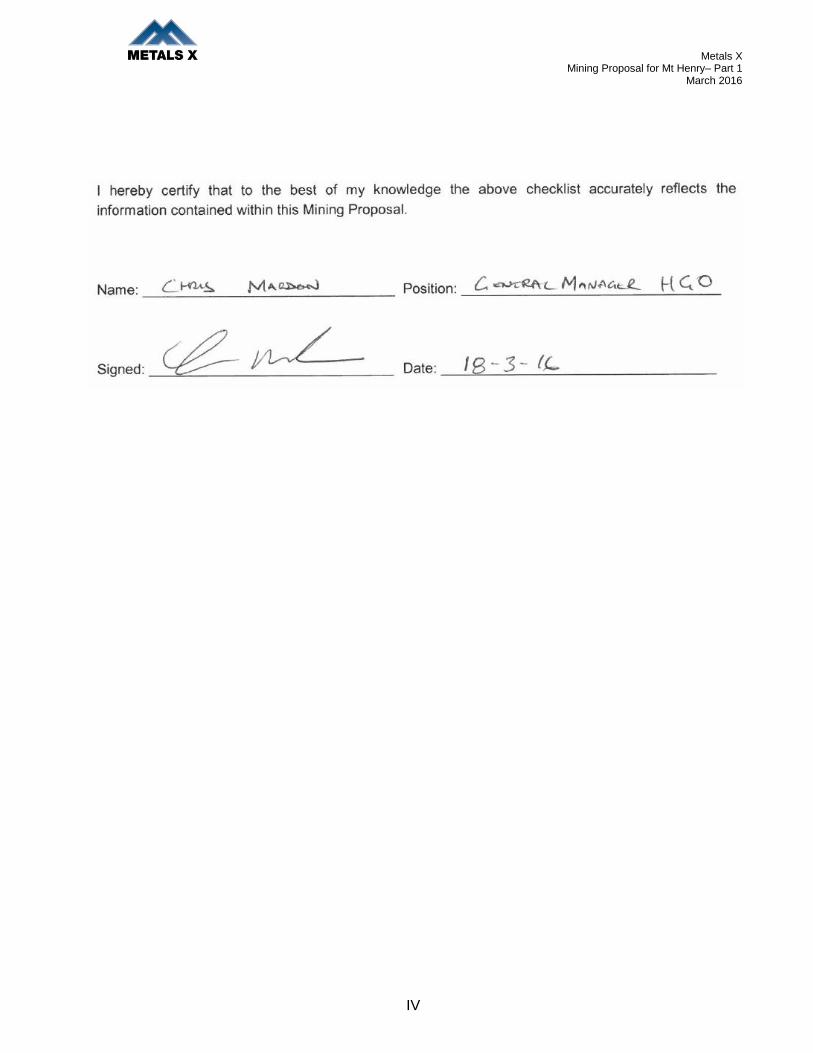
5 Has the Mining Proposal been endorsed? (See last page Checklist.)
Y
Mining Proposal Details
6 Have you included the tenement number(s), site name, proposal overview and date in the title page?
Y
7 Who authored the Mining Proposal? Metals X
8 State who to contact for enquiries about the Mining Proposal?
Kellie Carter, Environmental Department, Higginsville Gold Operations
9 How many copies were submitted to DMP? Hard Copies = 1 DMP Office Kalgoorlie
Electronic = 1. Online
10 Is this Mining Proposal to support lease application?
N In future application for P63/1890 to a General
Lease to be applied
11 Has a Geological Resource Statement been included (refer section 4.3.2 of Mining Proposal Guidelines)
Y Refer Table 2
12 Will more than 10 million tonnes of ore and waste be extracted per year? State total tonnage.
N
13 Will more than 2 million tonnes or ore be processed per year? State total throughput.
N Supplementing feed to the Higginsville Gold
Operation
14 Is the Mining Proposal located on pre-1899 Crown Grant Land? (not subject to the Mining Act 1978)
N
15 Is the Mining Proposal located on Reserve Land? If ‘Yes’ state Reserve types in space below:
N No mining activities or infrastructure or clearing located on Reserve land.
16 Will the Mining Proposal occur within or affect a declared occupied town site?
N
17 Is the Mining Proposal within 2 km of the coastline or a Private Conservation Reserve?
N
18 Is the Mining Proposal wholly or partially within a World Heritage Property, Biosphere Reserve, Heritage Site or Soil Reference Site.
N

Metals X Mining Proposal for Mt Henry– Part 1
March 2016
II
Tenement Details
19 Are all mining operations within granted or applied for tenement boundaries?
Y
20 Are you the tenement holder of all tenements? Y
21 If ‘No’ at 20, do you have written authorisation from the tenement holder(s) to undertake the Mining Proposal activities? (Refer to section 4.2.1 of the Mining Proposal Guidelines)
N/A
22 Is ‘Yes’ at 21, then is a copy of the authorisation contained within the Mining Proposal?
N/A
23 Have you checked for compliance against tenement conditions?
Y All conditions checked up on DMP database Mineral Titles Online
Location and Site Layout Plans
24 Have you included location plans showing tenement boundaries and mining operations?
Y Appendix 1
25 Have you included site layout plans showing all mining operations and infrastructure in relation to tenement boundaries?
Y Appendix 1
26 Have you included “Area of Disturbance Tables” for all tenements impacted by mining operations?
Y Table 9
Environmental Protection Act
27 Does the Mining Proposal require referral under Part IV or the MOU? If ‘Yes’ describe why in space below:
N
28 Has the EPA set a level of assessment? If yes state:
N/A
29 Is a clearing permit required? If ‘No’ then explain why in space below?
Y
30 If ‘Yes’ at Q29 then has a permit been applied for?
Y Yes Approved
31 Is a Works Approval required by the DEC (formerly DoE)?
N
32 Has a Works Approval application been submitted to the DEC (formerly DoE)?
N
Metals X Mining Proposal for Mt Henry– Part 1
March 2016
III
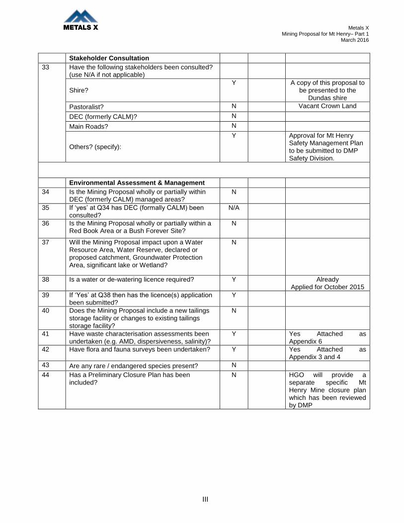
Stakeholder Consultation
33 Have the following stakeholders been consulted? (use N/A if not applicable)
Shire?
Y A copy of this proposal to be presented to the
Dundas shire
Pastoralist? N Vacant Crown Land
DEC (formerly CALM)? N
Main Roads? N
Others? (specify):
Y Approval for Mt Henry Safety Management Plan to be submitted to DMP Safety Division.
Environmental Assessment & Management
34 Is the Mining Proposal wholly or partially within DEC (formerly CALM) managed areas?
N
35 If ‘yes’ at Q34 has DEC (formally CALM) been consulted?
N/A
36 Is the Mining Proposal wholly or partially within a Red Book Area or a Bush Forever Site?
N
37 Will the Mining Proposal impact upon a Water Resource Area, Water Reserve, declared or proposed catchment, Groundwater Protection Area, significant lake or Wetland?
N
38 Is a water or de-watering licence required? Y Already Applied for October 2015
39 If ‘Yes’ at Q38 then has the licence(s) application been submitted?
Y
40 Does the Mining Proposal include a new tailings storage facility or changes to existing tailings storage facility?
N
41 Have waste characterisation assessments been undertaken (e.g. AMD, dispersiveness, salinity)?
Y Yes Attached as Appendix 6
42 Have flora and fauna surveys been undertaken? Y Yes Attached as Appendix 3 and 4
43 Are any rare / endangered species present? N
44 Has a Preliminary Closure Plan has been included?
N HGO will provide a separate specific Mt Henry Mine closure plan which has been reviewed by DMP
Metals X Mining Proposal for Mt Henry– Part 1
March 2016
IV

Metals X Mining Proposal for Mt Henry– Part 1
March 2016
V
Table of Contents ___________________________________________________________________________________________________________________________________________________________________________________
1. SUMMARY AND COMMITMENTS ............................................................................................. 1
2. BACKGROUND INFORMATION ................................................................................................ 2
2.1. OWNERSHIP.......................................................................................................................... 3
2.2. PROJECT OBJECTIVES ........................................................................................................... 3
2.3. LOCATION AND SITE LAYOUT PLANS ....................................................................................... 4
2.4. HISTORY ............................................................................................................................... 8
2.5. EXISTING FACILITIES ............................................................................................................. 9
3. EXISTING ENVIRONMENT ...................................................................................................... 10
3.1. REGIONAL GEOLOGY ........................................................................................................... 10
3.2. LOCAL GEOLOGY (MT HENRY PIT) ....................................................................................... 11
3.3. CHARACTERISATION OF WASTE ROCK AND TAILINGS ............................................................. 12
3.4. LANDFORM AND SOILS ......................................................................................................... 15
3.5. REGIONAL HYDROGEOLOGY ................................................................................................ 16
3.5.1. Mt Henry Pit Hydrogeology ........................................................................................ 16
3.6. CLIMATE ............................................................................................................................. 18
3.7. SURFACE DRAINAGE ........................................................................................................... 18
3.8. FLORA ................................................................................................................................ 19
3.9. FAUNA ................................................................................................................................ 22
3.10. SOCIAL ENVIRONMENT ........................................................................................................ 25
4. PROJECT DESCRIPTION ........................................................................................................ 27
4.1. AREA OF DISTURBANCE ....................................................................................................... 27
4.2. MINING OPERATIONS- MT HENRY PIT ................................................................................... 27
4.3. ORE TRANSPORT ................................................................................................................ 31
4.4. ORE PROCESSING .............................................................................................................. 31
4.5. TAILINGS STORAGE ............................................................................................................. 31
4.6. SUPPORT FACILITIES ........................................................................................................... 31
4.7. WORKFORCE ...................................................................................................................... 32
4.8. RESOURCE REQUIREMENTS AND REGIONAL INFRASTRUCTURE .............................................. 32
4.9. COMPLIANCE WITH LEGISLATION AND OTHER APPROVALS ..................................................... 32
5. ENVIRONMENTAL IMPACTS AND MANAGEMENT ............................................................... 33
5.1. LAND CLEARING .................................................................................................................. 33
5.2. WATER ............................................................................................................................... 34
5.2.1. Groundwater .............................................................................................................. 34

Metals X Mining Proposal for Mt Henry– Part 1
March 2016
VI
5.2.2. Potable Water ............................................................................................................ 34
5.3. FLORA, FAUNA AND ECOSYSTEM .......................................................................................... 34
5.4. TOPSOIL AND SOIL PROFILES ............................................................................................... 35
5.5. DOMESTIC AND INDUSTRIAL WASTE PRODUCTS .................................................................... 35
5.6. TAILINGS MANAGEMENT ...................................................................................................... 35
5.7. WASTE ROCK DUMP DESIGN ............................................................................................... 35
5.8. WASTE ROCK DUMP PAF MANAGEMENT .............................................................................. 39
5.9. HYDROCARBON MANAGEMENT ............................................................................................. 41
5.10. DANGEROUS GOODS AND HAZARDOUS SUBSTANCES ............................................................ 41
5.11. ATMOSPHERIC POLLUTION AND NOISE .................................................................................. 41
6. SOCIAL IMPACTS ................................................................................................................... 43
6.1. HERITAGE ........................................................................................................................... 43
6.2. LAND USE AND COMMUNITY ................................................................................................. 43
6.3. SOCIAL ENVIRONMENT ........................................................................................................ 43
6.4. WORKFORCE INDUCTION AND TRAINING ................................................................................ 44
7. MINE CLOSURE ...................................................................................................................... 45
7.1. POST MINING LAND USE ...................................................................................................... 46
7.2. REHABILITATION .................................................................................................................. 46
7.2.1. General Closure Implementation Management Actions ............................................. 46
7.2.2. Open Pit .................................................................................................................... 47
7.2.3. Waste Rock Final Landform ....................................................................................... 48
7.2.4. Administration, Workshop and Infrastructure ............................................................. 49
7.2.5. Water Management and Drainage Structures ............................................................ 49
7.2.6. Roads, Corridors and Fences .................................................................................... 50
7.2.7. Exploration ................................................................................................................ 50
7.3. STRATEGIC FRAMEWORK FOR MINE CLOSURE ...................................................................... 50
7.4. SUBMISSION OF MINE CLOSURE PLAN DOCUMENTS .............................................................. 51
Appendix 1 Site Layout Plans Appendix 2 Higginsville Environmental Management Plan Appendix 3 Flora Report- Mattiske Appendix 4 Fauna Report- Western Wildlife Appendix 5 Groundwater Report- GDS
Appendix 6 Geochemical Analysis of Waste Material- RGS

Metals X Mining Proposal for Mt Henry– Part 1
March 2016
1
1. SUMMARY AND COMMITMENTS
The Mt Henry Gold Operation is located 20 km south of Norseman and 70 km south of the
Higginsville Gold Operations in the Goldfields region of Western Australia. Mt Henry Pit is accessed
via the goldfields Esperance highway via a haul road on L63/64. This Mt Henry Part 1 Mining
Proposal comprises the following mining leases:
M63/515: Mt Henry Pit, ROM, Water Dam, Site Office, Workshop, Topsoil Stockpiles, Mawson
Waste Dump, Woodward Waste Dump Stage 1
L63/64: Main Access Road
Commitments to reduce potential environmental risks and issues associated with the development of
the Mt Henry Mining Proposal Part 1 include:
Commitment 1: All clearing will be preapproved and viewed by the Environmental
Coordinator.
Commitment 2: Dust suppression through the use of saline groundwater will be used on
haul roads to minimise the impacts of dust on the surrounding
environment.
Commitment 3: Drains, culverts and catchment sumps will be constructed along all land-
based roads and surface infrastructure to prevent the egress of hyper-
saline water to the surrounding vegetation except under heavy rainfall
conditions.
Commitment 4: Higginsville Gold Operations has developed an Environmental
Management Plan, including procedures to ensure that the
environmental impacts of the project are minimised and Mt Henry will fit
within the overall Higginsville Gold Project plan.
Commitment 5: An updated specific mine closure plan has been documented for Mt
Henry, it is Higginsville Gold Operations proposal to incorporate this
closure plan into the Higginsville Site closure plan which is due for
resubmission in 2016. Various knowledge gaps and additional
commitments within the plans and this mining proposal will be included
within the new plan.
Commitment 6: A new Safety Bund wall around the Mt Henry pit will be constructed with
fresh rock prior to pit being closed off and project finished.
Commitment 7: Mt Henry Pit entrances will be bunded; to stop public access to pits once
mining is complete.
Commitment 8: Mt Henry pit waste dump primary earthworks will be finished during life
of project or within 6 months of Mt Henry mining being completed.
Including spreading topsoil, subsoil, mulch, contour ripping and seeding
of waste dump.

Metals X Mining Proposal for Mt Henry– Part 1
March 2016
2
2. BACKGROUND INFORMATION
Gold was first discovered in the Dundas Hills area in 1892, which resulted in gold prospectors moving
into the area and establishing the townsite of Dundas in 1893, which is located in close proximity to
the project. In 1894 Norseman was established and as it was in a location of richer goldfields, it
gradually outgrew the Dundas townsite. The townsite, which was located just west of the Mt Henry
Joint Venture tenements, was eventually abandoned. A commemorative plaque remains there today.
The Central Norseman Gold Corporation held most of the tenements in the project area from 1935 to
1980. Since that time exploration activities have occurred under several companies, with mining of
the Mt Henry Pit and underground occurring from 1982-1988 on M63/515 by Australis Mining NL. No
approvals for this historic mining are listed on tenement conditions.
In 2010, DMP approved a Mining Proposal to develop the Mt Henry Pit however the proposal was
never implemented. The following shows a timeline of recent activity in the Mt Henry area:
2010 – DMP approved a Mining Proposal for a mining operation around the Mt Henry deposit for Matsa.
2011 – Panoramic entered into a Joint Venture with Matsa.
2011 – 2014 – Ongoing exploration and baseline studies.
2015 – Metals X acquired the Mt Henry Gold Project from Panoramic and Matsa
February 2016 – Metals X commenced Infill drilling of the Mt Henry Pit Area.
This Mining Proposal, termed Mt Henry Mining Proposal Part 1, is associated with the cut back/open
pit mining of Mt Henry Pit and carting ore via the Goldfields Esperance Highway to Higginsville Gold
Operations for complete processing. Higginsville’s 1Mtpa treatment plant has been in operation since
2008 and will be utilised to treat the large low grade, low strip ratio Mt Henry open cut pit. Future
plans to extend the Mt Henry Woodward waste dump (Stage 2) as well as mine two additional
deposits Selene and North Scotia will be presented in the future, within separate mining proposals.
In November 2013, the Department of Mines and Petroleum accepted the Higginsville Gold
Operations Mine Closure Plan which is due for resubmission in 2016.
Mt Henry also has a specific mine closure plan written with this mining proposal. In 2016 Metals X
propose that the two closure plans be incorporated into the one. Various knowledge gaps and
additional commitments within the existing plans and this mining proposal will be incorporated into the
new plan.

Metals X Mining Proposal for Mt Henry– Part 1
March 2016
3
2.1. OWNERSHIP
Ownership details of tenements are listed in Table 1 below. Avoca Mining Pty Ltd are wholly owned
subsidiaries of Metals X Limited, which therefore own 100% of the Mt Henry tenements.
Tenement Owner % Ownership
M63/515
L63/64
Avoca Mining Pty Ltd
Avoca Mining Pty Ltd
100%
100%
Table 1: Ownership Details
M63/515: Mt Henry Pit, ROM, Water Dam, Site Office, Workshop, Topsoil Stockpiles, Mawson
Waste Dump, Woodward Waste Dump Stage 1
L63/64: Main Access Road
2.2. PROJECT OBJECTIVES
The key objectives and project resource for the Mt Henry Pit are detailed in Table 2.
Key Project Objectives
Mineral to be Mined Gold
Ore 8,339,050t @1.49g/t
Minable Ounces 367,000 oz
Strip Ratio 5:1
Waste rock materials – Total 41,846,931t
Approx Main Surface RL 270mRL
Top of Ridge Surface RL 223mRL
Depth of Void 150 meters
Water table depth 10-35 meters below surface
Open Pit Mining Method Conventional - 5m Benches
Maximum mill feed rate (with inferred) 110,000 tonnes per month
Life of Mine (Reserve / with inferred) 60 months Recovery (Au) 90%
Resource (Indicated & Inferred) 17,964,[email protected]/t
Resource ounces (Indicated & Inferred) 775,879 oz
Project Resources as of Date March 2015 Optimised By Intermine Engineering Consultants
Table 2: Key Objectives / Project Resource for the Mt Henry Pit
The prime objective of this proposal is the mining of Mt Henry Pit as additional feed to the Higginsville
treatment plant. The following assumptions explain the project in further detail.

Metals X Mining Proposal for Mt Henry– Part 1
March 2016
4
1. A majority of this development utilises land/tenements that were previously mined in the
1980’s by Australis Mining NL, previous tenement holders include Matsa Resources Limited
and Panoramic Resources Limited
2. The Mt Henry pit mineralisation strikes north to South for a distance of 1.0km and extends
from the top of the ridge line to a depth of 270m. Mineralisation primarily consists of broad
zones up to 35m in width with a number of narrower lodes adjacent dipping at approximately
70° to the west.
3. Ore will be hauled from the Mt Henry Pit via the Coolgardie Esperance Highway to Higginsville
Gold Operations for processing which is approximately 85 km in distance
4. Ore produced will be treated at the Higginsville Treatment Plant which was commissioned in
June 2008 and is currently being fed from the Trident underground mine and Lake Cowan
open pits.
5. Workforce will be obtained for Mt Henry project from the local regional centres including
Norseman and will supplement with fly-in, fly-out personnel from Perth.
6. Minimal resources and set up is required, as it will be done as part of the existing Higginsville
Gold Project, with only a site office and workshop being set up at Mt Henry
7. Mining of Mt Henry pit is medium term with an expected timeframe of approximately 60
months, and will be mined in conjunction with other ore source from the Higginsville Gold
operations.
8. A lease application to convert P63/1890 to G63/7 is currently in progress as soon as it is
approved an addendum to this Mining Proposal will be submitted allowing the extension of the
Woodward Waste dump to the West.
2.3. LOCATION AND SITE LAYOUT PLANS
As shown in Figure 1 The Mt Henry Gold Operation is located 20 km south of Norseman and 70 km
south of the Higginsville Gold Operations in the Goldfields region of Western Australia A larger set of
site layout plans is included in Appendix 1 of this Mining Proposal.
These site plans Figures 1 - 3, show the conceptual layout of the proposed Mt Henry pit, mining area
and surrounding infrastructure tenement boundaries.

Metals X Mining Proposal for Mt Henry– Part 1
March 2016
5
Figure 1: Higginsville / Mt Henry location

Metals X Mining Proposal for Mt Henry– Part 1
March 2016
6
Figure 2: Mt Henry tenure

Metals X Mining Proposal for Mt Henry– Part 1
March 2016
7
Figure 3: Proposed Mt Henry Pit

Metals X Mining Proposal for Mt Henry– Part 1
March 2016
8
2.4. HISTORY
Higginsville Gold Operations currently operates in two main project areas Higginsville and Lake
Cowan with Mt Henry being the 3rd and new project area. Chalice mine is currently in care and
maintenance.
Higginsville Gold Operations commenced in 2006 with preparation of the Trident underground gold
mine followed by a new mill being constructed a few years later. Table 3 is a history of Higginsville
Gold Operations approved mining projects/proposals.
Mining Proposal – Document Title Date Approved DMP Reference
Number
Mining Proposal Trident– (Part 1)
March 2006
5316
Mining Proposal Trident – (Part 2) January 2007 5612
Mining Proposal Trident – (Part 3) July 2007 5729
Mining Proposal Higginsville Tailings Storage Facility (TSF) December 2007 5888
Mining Proposal Trident – (Part 4) April 2008 5926
Mining Proposal Pastefill Plant March 2009 21320
Mining Proposal Fairplay Open Pit (Part1) March 2010 24663 & 26039
Mining Proposal Dewater Chalice Pit to Aphrodite Pit June 2010 26797
Mining Proposal Dewater Chalice Pit to Chalice West Lake January 2011 28042
Mining Proposal for Chalice Underground Mine (Part 1) March 2011 29493
Mining Proposal for Vine Open Pit (Part 1) April 2011 30107
Mining Proposal for Chalice Underground Mine (Part 2) September 2011 31259
Mining Proposal for Vine Open Pit (Part 2) October 2011 32103
Mining Proposal for Fairplay Pit (Part 2) (Fairplay North Pit) May 2012 33947
Mining Proposal for Higginsville TSF Lift August 2012 35354
Mining Proposal for Corona Underground (Part 1) September 2012 36144
Mining Proposal for Chalice Underground Mine (Part 3)
Integrated Waste landform
June 2013 39370
Mining Proposal Mining of Chalice Gravel Pit October 2013 43220
Mining Proposal Dewater Chalice Underground to Chalice
West Lake
January 2014 43791
Mining Proposal Lake Cowan Part 1 (Louis Pit) April 2014 47320
Mining Proposal Lake Cowan Part 2 (Josephine pit and
Haul Road)
August 2014 50744
Mining Proposal Lake Cowan Part 3 (Napoleon Pit) December 2014 53122
Mining Proposal Aphrodite Inpit TSF September 2015 55735
Mining Proposal Fairplay Pits Part 3 (Fairplay North Pit,
East Pit and Cutback Pits)
October 2015 56173
Mining Proposal Mt Henry Part 1 (this document)
Table 3: HGO’s approved Mining Proposals.

Metals X Mining Proposal for Mt Henry– Part 1
March 2016
9
2.5. EXISTING FACILITIES
The mining related disturbances associated with mining at Mt Henry pit by Australis Mining NL in the
1980’s are still visible and Metals X is using these previously disturbed areas as much as possible for
the mining and expansion of the Mt Henry pit. Apart from existing mining disturbances there are no
existing physical facilities on site. The Coolgardie Esperance Highway will be utilised for access to
the site and for transportation of the ore to the Higginsville Gold Operation for processing.
The existing Higginsville accommodation village will continue to be used for the housing of personnel
as well as local accommodation within the Norseman community.

Metals X Mining Proposal for Mt Henry– Part 1
March 2016
10
3. EXISTING ENVIRONMENT
3.1. REGIONAL GEOLOGY
Greenstone rocks of the Norseman region can be broadly correlated with the Kalgoorlie-Kambalda
region in that they form a distinct lithology which is bounded on all sides by major regional shears.
The Norseman Terrane has prominent Banded Iron Formation (BIF), which distinguishes it from the
Kalgoorlie-Kambalda lithology.
The Archean rocks in the Norseman area have been classified into the following series of formations:
Penneshaw Formation: The Penneshaw Formation forms the greenstone sequence on the eastern
side of the belt. It consists of mafic volcanic rocks with interlayered units of felsic volcaniclastic and
sedimentary rocks, and is intruded by doleritic sills and dykes. This formation is intruded by the
Buldania Granite complex in the east and is structurally overlain by the Noganyer formation in the
west.
Noganyer Formation: The Noganyer Formation forms a distinct sedimentary sequence of siliclastic
rocks, principally silicate facies BIF, chert, sandstone and shales. Intrusion of dolerite dykes and
sills are common throughout. The Mt Henry and Selene gold deposits are hosted in the Noganyer
Formation. This formation is conformably overlain by the Woolyeenyer Formation.
Woolyeenyer Formation: The Woolyeener Formation both dips and faces west and consists of a
sequence of mafic volcanic rocks with minor ultramafics and sedimentary units. Syn-volcanic
dolerite dykes and sills intrude the strata and Noganyer Formation below. This formation hosts the
Norseman style quartz reef gold mineralisation as well as the Abbotshall gold deposit which is
hosted in a regionally extensive porphyry/siliceous sedimentary unit of the Woolyeenyer Formation.
It is unconformably overlain by the Mt Kirk Formation.
Mt Kirk Formation: The Mt Kirk Formation consists of felsic volcanic and sedimentary rocks which
are intruded by large, thick mafic sills. The Mt Kirk Formation is bounded to the west by a granite-
gneiss complex. No gold deposits have been found in the Mt Kirk Formation.
Intrusive Rocks: Intrusive rocks in the Norseman area comprise:
Large external granitoid complexes that bound the greenstone belt to the southeast and
southwest.
A suite of domal granites and porphyry that intrude the western granitoid complex and the
Woolyeenyer Formation.
Stocks of potassic granite and associated pegmatite.
Proterozoic dolerite dykes that intrude sets of east-west fractures in the craton.
The solid rock geology is overlain by Quaternary and Tertiary sediments, comprising aeolian dune
deposits, alluvium and colluvium. These include Tertiary Wollubar Sandstone which forms the basal
sand within the palaeochannels. These are overlain by silts and clays of the Perkolilli Shale, which
outcrop under Lake Dundas and the greater Lake Cowan palaeochannel system.

Metals X Mining Proposal for Mt Henry– Part 1
March 2016
11
3.2. LOCAL GEOLOGY (MT HENRY PIT)
The Mt Henry deposit is hosted in the Noganyer Formation as described in the above section. The
host rock is predominantly silicate facies BIF with minor meta-basalts and dolerites. Sulfide minerals
range from trace to 10%. The predominant sulfide mineral is pyrrhotite with minor pyrite, arsenopyrite,
chalcopyrite and marcasite. Gold occurs in narrow and discrete quartz veins in clouds with silicate
minerals. It also occurs in close proximity to sulfide minerals, particularly pyrrhotite.
The main lode is an elongated orebody that is 1.9 km long, six to ten meters wide and dips at 65º
towards the west. It occurs as a mineralised shear usually (but not always) along the hanging wall
contact of the BIF. The mineralisation can occur along the contacts and into the overlying chert and
dolerites of the Woolyeenyer Formation as well as underlying dolerite sills where they occur.
The shear that hosts the mineralisation within the BIF strikes north to south and dips 65º towards the
west, paralleling the stratigraphy. Late pegmatite dykes cut across all previous geology and deplete
mineralisation where they cross the lodes. Apart from the main lode, there are several minor footwall
lodes and two discrete supergene lodes.
Oxidation goes to a maximum depth of 30 m in pockets. As the ore zones are high in sulfides, the
ore body is more oxidised than the hanging wall and footwall waste rocks. It has been assumed that
the rocks will be fairly “fresh” from depth 20 to 30 m from the natural surface, and that the first few
metres will be transitional.
Figure 4: Cross-section of the geology of the Mt Henry Pit showing key geological features

Metals X Mining Proposal for Mt Henry– Part 1
March 2016
12
3.3. CHARACTERISATION OF WASTE ROCK AND TAILINGS
No new or any increases amounts of tailings will be produced as a result of this proposal. All ore will
be trucked and treated at the Higginsville Gold Operations treatment plant.
Several material characterisation assessments have been undertaken at the project over the past few
years. The most recent and comprehensive assessment was undertaken by consultant RGS (2014)
where 148 waste rock samples were collected from 42 drill holes providing a good representation of
all the waste rock expected to be generated at the Mt Henry Pit. This report is attached as Appendix
6; Figure 5 shows waste characterisation sample location within Mt Henry Pit.
Figure 5: Waste characterisation sample location within Mt Henry pit.

Metals X Mining Proposal for Mt Henry– Part 1
March 2016
13
There are five waste rock types identified within the Mt Henry pit. Percentages of the waste type are
listed in Table 4. A portion of waste rock is classified as Predominantly Acid Forming (PAF). This is
contained within the BIF, it is easily recognisable and can be visually identified in advance of
excavation and an appropriate destination planned for the material.
Percentage of
Waste Within
the Mt Henry
Deposit
Waste Type Preliminary Characteristics
50% Mafic basalt and dolerite Predominantly Non Acid Forming (NAF)
33.% Banded Iron Formation (BIF) Predominantly Acid Forming (PAF)
6% Pegmatites Predominantly Non Acid Forming (NAF)
11% Sediments and schists Variable
>1% Quartz reef Non Acid Forming (NAF)
Table 4 Mt Henry pit waste characterisation.
PAF waste will be managed by encapsulating the PAF material within no acid forming (NAF) material
prior to completion of the waste dumps. Details on the dump construction can be seen in Section.5
A summary of waste rock physical characteristics is taken from Appendix 6 is below:
The Mt Henry project has undergone characterisation with respect to sodicity, salinity (in leachate),
dispersive potential and particle size distribution. Investigation findings are set forth below followed by
a discussion of the influence of material characterisation on mine planning and landform design.
Cation Exchange Capacity and Sodicity: The effective cation exchange capacity (eCEC) and
exchangeable sodium percentage (ESP) results for 12 selected samples (8 Mafic B&D and 4
Pegmatite waste rock samples from the 22 composite waste rock samples described in the RGC
Report. These rock types were selected for testing as they are likely to report to the outer surfaces of
waste rock dump facilities.
The exchangeable cation results indicate that the eCEC of the 12 waste rock samples ranges from
2.6 to low 24 meq/100g, and is typically low (median = 9.4 meq/100g). The eCEC values for
Pegmatite are typically in the “very low” range compared to the “moderate” range for Mafic B&D
(Table 4-3).

Metals X Mining Proposal for Mt Henry– Part 1
March 2016
14
The ESP results for the waste rock samples range from low (2.8%) to high (44.9%) and are typically
low for Pegmatite and slightly elevated for Mafic B&D, indicating that Mafic B&D is likely to be non-
sodic and that Pegmatite could be moderately sodic. Generally samples with ESP values less than 6
are considered non-sodic, whereas greater than 6 are considered moderately sodic, and greater than
14 are considered strongly sodic and may be susceptible to dispersion and erosion (Isbell, 2002; and
Northcote and Skene, 1972).
Overall, the results of the eCEC and ESP tests on the waste rock samples indicate that the materials
represented by these samples are likely to have low to moderate sodicity levels (dependant on rock
type) and have a low to moderate risk of being susceptible to dispersion and erosion.
Particle Size Distribution and Emerson Aggregate Tests: In order to further investigate the
potential for using waste rock materials as part of construction, revegetation and rehabilitation
activities at the Project, Particle Size Distribution (PSD) and Emerson Aggregate tests were
completed on the representative composite samples of waste rock materials described above. The
results from the PSD tests and Emerson Aggregate test are provided in the RGC report. Whilst
performed on crushed materials, these tests are required to address recommendations in WA
guidelines for preparing Mine Closure Plans (DMP and EPA 2011).
The PSD results indicate that the samples are described as sandy gravel and generally have a
particle size distribution range that goes from silt to fine gravel. For most samples, at least 50% of the
sample passes through a 2.36 mm screen size.
The Emerson Aggregate Test results indicate that all samples are classified in the range Emerson
Class 5 to 8, which suggests that the materials are either non-dispersive (Mafic B&D) or have a
relatively low propensity to disperse (Pegmatite). These test results align reasonably well with the
findings of the eCEC and ESP results.
Salinity: The EC value of KLC leachate from most waste rock samples is relatively low and less than
1,000 μS/cm. Three waste rock samples have EC values in initial leachate greater than 1,000 μS/cm
[Mafic B&D (Mt Henry)-2], Mafic B&D (Mt Henry)-7, however the data show a decreasing trend and
most EC values remain significantly less than 500 μS/cm after two years of leaching. The initial
elevated EC values are probably due to the increased solubility of minerals through crushing the
waste rock materials before loading into the KLC test columns.

Metals X Mining Proposal for Mt Henry– Part 1
March 2016
15
3.4. LANDFORM AND SOILS
Between Norseman and Kalgoorlie there is a concentration of greenstone belts that contain a mixture
of metamorphosed mafic to ultramafic volcanic rocks (including basalt, amphibolite, dolerite and
gabbro), felsic volcanic rocks, and meta sedimentary rocks (including cherts and banded iron
formations) Mt Henry project lies at the southern extent of the NorsemanWiluna Greenstone Belt and
is described as zone 265 as per described by P Tille 2006, Soil Landscapes of WA’s Rangelands
and Arid Interior, Figure 6.
Figure 6: Soil landscape zones of the Kalgoorlie provence.
“The undulating plains have extensive areas of calcareous loamy earths with red loamy earths and
red loamy duplexes (shallow and deep). Red/brown and yellow loamy earths, red shallow sands and
cracking clays are also present. Salt lake soils are present in saline valley floors and Red deep sands
are found on lunettes associated with lakes. The gently sloping uplands on granite have yellow sandy
earths and yellow loamy earths, with some yellow deep sands and ironstone gravelly soils. The hilly
terrain on greenstone has red loamy earths, calcareous loamy earths and calcareous shallow loams,
along with stony soils and red shallow loams. Sand plains have red deep sands, with some yellow
deep sands in the west. On the sandy surfaced plains there are red deep sands and red loamy earths
with red sandy earths”
(Department of Agriculture and Food, 2006, Soil landscapes of WAs Rangelands and Arid Interior, P.
Tille)
Generally soils in the goldfields region are typically alkaline with a pH range of 7.0 to 9, low soil
fertility and electrical conductivity of 14mS/cm, indicating moderate soil salinity. Section 5.4 details
topsoil management.

Metals X Mining Proposal for Mt Henry– Part 1
March 2016
16
3.5. REGIONAL HYDROGEOLOGY
(Section 3.5 extracted from H1 Desktop Hydrogeological Assessment, Mt Henry Open Pits, October
2015, complete by Groundwater Development Services)- Attached as Appendix 5.
Groundwater in the area is characterised by low relief and easterly draining palaeo-drainage systems
underlain by Archean sequences. Groundwater levels range from 250 to 275 mAHD at the Mt Henry
deposit and around 245mAHD at Lake Dundas.
In this area, groundwater typically occurs in:
Regional catchment controlled flow systems in fresh and weathered fractured rock aquifers.
Tertiary palaeochannel sands (Wollubar Sandstone).
Calcrete units that commonly overlie palaeochannel deposits.
Shallow alluvium.
Groundwater recharge by direct rainfall infiltration or by stream flow during episodic rainfall events
occurs mainly on or adjacent to the catchment divides, beneath which there are corresponding,
subdued groundwater divides. The groundwater moves from these divides to discharge into salt
lakes along the palaeo-drainages. In the salt lake’s the groundwater is evaporated and concentrated
to brine, which then descends and moves downstream in the palaeochannel sand to eventually
discharge into the Eucla Basin
Groundwater salinities in the project area typically range from about 1,000 to 200,000 mg/L Total
Dissolved Solids (TDS). Low salinity groundwater, ranging from 1,000 to 5,000 mg/L TDS occurs in
areas most affected by direct rainfall recharge, e.g. near catchment divides and within shallow
alluvium and calcrete units. The highest salinity groundwater occurs low down in the catchments
within palaeochannel sands and deeper fractured rock aquifers.
Small supplies of groundwater can be found throughout the area. Large, fresh groundwater supplies
are rare, but large, reliable supplies of saline to hypersaline groundwater are obtainable from the
palaeochannel sand and site specific shear zones and deeply oxidised zones in the fractured rocks.
3.5.1. MT HENRY PIT HYDROGEOLOGY
Indications at present are that Mt Henry pit will produce saline groundwater at a maximum flow rate
(~5.5 litre/sec) and be intersected between 10-35 meters below surface, after which a sump will be
constructed within the Pit and water utilised for dust control from a water cart. The dust control
requirements at project commencement may not be met through pit dewatering so an alternative plan
is to install a lake drainage interception trench on the edge of Lake Dundas (Described water dam on
maps) to extract further groundwater at project commencement. Water extraction licences have

Metals X Mining Proposal for Mt Henry– Part 1
March 2016
17
currently been applied for at the Mt Henry Project area. It is envisaged that as part of the groundwater
licence pit water and groundwater extraction points will be sampled and water level recorded
quarterly until the end of the mining operation.
Groundwater salinity of the Mt Henry pit ranges from 10,000 mg/L (MTHWE02) in the north to
121,000 mg/L TDS (MTHWE07) in the south. It was concluded that groundwater salinity increased
down dip of the orebody lithology. Higher salinity was considered to be representative of the ambient
groundwater quality in the crystalline bedrock. The analytical results have been reproduced below in
Table 5. The water quality results show hypersaline water quality which is representative of
groundwater and surface water in the Dundas Paleodrainage system.
Analyte Unit MTHWE02 MTHWE03 MTHWE04 MTHWE07
pH 7.3 7.5 7.7 7.1
Total Dissolved Solids mg/L 10,000 17,400 18,200 121,000
Electrical Conductivity mS/cm 16 20 27 140
Bicarbonate alkalinity as HCO3 mg/L 240 320 460 170
Carbonate alkalinity as CO3 mg/L <1 <1 <1 <1
Hydroxide alkalinity as OH mg/L <5 <5 <5 <5
Total alkalinity as CaCO3 mg/L 190 260 380 140
Chloride mg/L 4,100 5,700 6,900 63,000
Sulphate mg/L 2,200 5,100 5,000 9,200
Nitrate, NO3 mg/L <0.05 <0.05 0.06 <0.05
Aluminum, Al mg/L <0.02 <0.02 <0.1 <1
Arsenic, As mg/L <0.02 <0.02 <0.1 <1.0
Calcium, Ca mg/L 290 370 490 450
Cobalt, Co mg/L 0.01 0.02 <0.05 <0.05
Copper, Cu mg/L <0.005 <0.005 <0.025 <0.25
Iron, Fe mg/L 6.5 <0.02 <0.1 <1
Magnesium, Mg mg/L 550 800 1,000 5,700
Manganese, Mn mg/L 2.5 2.6 1.7 4.1
Nickel, Ni mg/L 0.024 0.099 0.062 0.39
Potassium, K mg/L 64 84 100 370
Silica, soluble mg/L 52 49 52 17
Silicon, Si mg/L 24 23 24 7.8
Sodium, Na mg/L 2,600 5,000 5,500 40,000
Zinc, Zn mg/L 0.03 0.09 <0.05 <0.05
Total hardness by calc CaCO3/L CaCO3//L 3,000 4,200 5,400 24,000
Table 5: Groundwater analysis results
Metals X Mining Proposal for Mt Henry– Part 1
March 2016
18
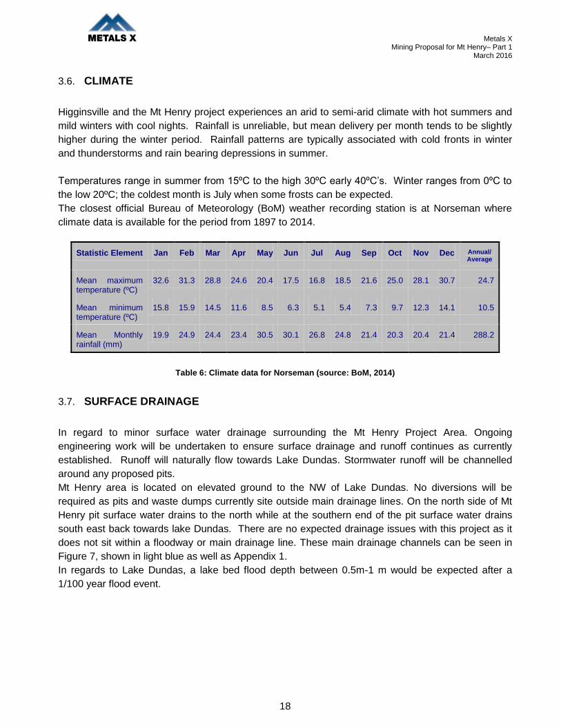
3.6. CLIMATE
Higginsville and the Mt Henry project experiences an arid to semi-arid climate with hot summers and
mild winters with cool nights. Rainfall is unreliable, but mean delivery per month tends to be slightly
higher during the winter period. Rainfall patterns are typically associated with cold fronts in winter
and thunderstorms and rain bearing depressions in summer.
Temperatures range in summer from 15ºC to the high 30ºC early 40ºC’s. Winter ranges from 0ºC to
the low 20ºC; the coldest month is July when some frosts can be expected.
The closest official Bureau of Meteorology (BoM) weather recording station is at Norseman where
climate data is available for the period from 1897 to 2014.
Statistic Element Jan Feb Mar Apr May Jun Jul Aug Sep Oct Nov Dec Annual/ Average
Mean maximum temperature (ºC)
32.6 31.3 28.8 24.6 20.4 17.5 16.8 18.5 21.6 25.0 28.1 30.7 24.7
Mean minimum temperature (ºC)
15.8 15.9 14.5 11.6 8.5 6.3 5.1 5.4 7.3 9.7 12.3 14.1 10.5
Mean Monthly rainfall (mm)
19.9 24.9 24.4 23.4 30.5 30.1 26.8 24.8 21.4 20.3 20.4 21.4 288.2
Table 6: Climate data for Norseman (source: BoM, 2014)
3.7. SURFACE DRAINAGE
In regard to minor surface water drainage surrounding the Mt Henry Project Area. Ongoing
engineering work will be undertaken to ensure surface drainage and runoff continues as currently
established. Runoff will naturally flow towards Lake Dundas. Stormwater runoff will be channelled
around any proposed pits.
Mt Henry area is located on elevated ground to the NW of Lake Dundas. No diversions will be
required as pits and waste dumps currently site outside main drainage lines. On the north side of Mt
Henry pit surface water drains to the north while at the southern end of the pit surface water drains
south east back towards lake Dundas. There are no expected drainage issues with this project as it
does not sit within a floodway or main drainage line. These main drainage channels can be seen in
Figure 7, shown in light blue as well as Appendix 1.
In regards to Lake Dundas, a lake bed flood depth between 0.5m-1 m would be expected after a
1/100 year flood event.

Metals X Mining Proposal for Mt Henry– Part 1
March 2016
19
Figure 7: Mt Henry surface water drainage lines (drawn in light blue)
3.8. FLORA
A flora and vegetation survey (3400ha) of the Mt Henry project area was undertaken by Mattiske
Consulting Pty Ltd (Mattiske) in 2012 and 2013. This report has been provided as Appendix 3 with
the summary presented below.
The initial Level 2 flora and vegetation survey was undertaken from 23 to 26 October 2012, and a
second survey from 10 to 14 June 2013 to capture seasonal variation and to provide more detailed
flora and vegetation data for the Mt Henry Project area. This mining proposal falls within this study
area.
No threatened flora species were recorded during the surveys, however, eight priority flora species
were recorded by Mattiske and a further three have been previously recorded by other consultants
within the Mt Henry survey area Table 7.

Metals X Mining Proposal for Mt Henry– Part 1
March 2016
20
SPECIES CONSERVATION
STATUS
MATTISKE
RECORD
OTHER
RECORD
Eucalyptus ?jimberlanica P1 X
Drosera salina P2 X1
Philotheca apiculata P2 X
Allocasuarina eriochlamys subsp. grossa P3 X
Beyeria sulcata var. truncata P3 X2
Cyathostemon sp. Salmon Gums (B. Archer 769) P3 X
Eremophila purpurascens P3 X
Eucalyptus brockwayi P3 X
Gnephosis sp. Norseman (K.R. Newbey 8096) P3 X2
Goodenia laevis subsp. laevis P3 X
Melaleuca coccinea P3 X
Note: ‘Other records’ are based on data sourced from 1Paul Armstrong and Associates (2004c); and
2Botanica Consulting (2010) consultant reports.
Table 7: Summary of priority flora species recorded in the Mt Henry Project Area
From a regional perspective, all priority species recorded in the Mt Henry survey area also occur in
areas outside the mining tenements. Priority species were predominantly recorded within vegetation
community W1, along ridges adjacent to Lake Dundas and hills within and surrounding the Mt Henry
pit. Priority species also occurred in the S2 and W3 communities on salt lake margins east of the
North Scotia pit. The extent of Eucalyptus brockwayi (P3) was mapped using individual records of its
occurrence (both MCPL and previous records) along with aerial photography of the area to place it
within a particular community type. The focus on the extent of Eucalyptus brockwayi was due to the
high number of individual recordings of the species within pit boundaries.
A number of other significant flora were recorded within the Mt Henry survey area including three
species (plus a potential four other species) that represented an extension of their currently known
ranges and three species (Lepidosperma sp. aff. lyonsii, Grevillea acuaria sens lat, Hibbertia
exasperata sens lat) that were undescribed or part of a species complex that will be further split. It is
possible that when these taxa are split, some may be described as priority species.
A total of eight introduced (weed) species were recorded within the Mt Henry survey area, however,
none are declared pest organisms pursuant to section 22 of the Biosecurity and Agriculture
Management Act 2007 (BAM Act).
Seven vegetation communities were described within the Mt Henry survey area (with a further 4
described outside the immediate impact boundaries to provide local context). This included three
woodland communities of mixed Eucalyptus spp. over various shrubs and four shrubland
communities on the salt lake margins and granite outcrops. These communities are similar to those
described in previous surveys of the area and reflect patterns consistent with regional vegetation of

Metals X Mining Proposal for Mt Henry– Part 1
March 2016
21
the Coolgardie bioregion and Great Western Woodlands.
The Mt Henry mining proposal falls within the vegetation communities W1
The Mt Henry pit area fall within the W1 vegetation classification:
Woodland to open woodland of Eucalyptus dundasii , Eucalyptus torquata and other mixed
Eucalyptus spp. over Melaleuca sheathiana , Exocarpos aphyllus , Scaevola spinescens , Alyxia
buxifolia , Eremophila glabra subsp. glabra and Pomaderris forrestiana over Westringia rigida and
Ptilotus obovatus on orange-brown clayey loam with gravel on slopes and ridges.
Figure 8 is a representative photo of W1 vegetation classification.
Figure 8: W1 vegetation classification
Mt Henry pit area has historical workings, minor open pit workings and exploration drilling that was
previously disturbed, rehabilitated and then disturbed again via exploration drilling. Figure 9 shows
current view of proposed Mt Henry Pit area.

Metals X Mining Proposal for Mt Henry– Part 1
March 2016
22
Higginsville Gold Operations also has an Environmental Management Plan within which has a fauna
management program, Mt Henry activities fall under this plan.
Figure 9: Mt Henry pit current disturbed area
3.9. FAUNA
Extension of mining activities in the study area is likely to result in the loss of some native
vegetation (and therefore fauna habitats). It is of low significance as most species are
expected to occur in the nearby protected Brockway Timber Reserve to the North of Mt Henry
and would move once vegetation clearing commences. All avian and migratory species are
mobile and will readily move to adjacent areas if disturbed and or they are seasonal occasional
visitors.
A Level 2 fauna survey of the Mt Henry area was undertaken in 2012 and 2013 by consultant
Western Wildlife with the summary of the report presented below and the full report attached as
Appendix 4. The survey was undertaken in accordance with Environmental Protection Authority
(EPA) Position Statement No.3 (EPA 2002) and EPA Guidance Statement 56 (EPA 2004). The
project area was surveyed in the spring from 6 – 19 November 2012, and late summer from 11 –22
February 2013.

Metals X Mining Proposal for Mt Henry– Part 1
March 2016
23
The methods used to sample the fauna of the area included:
Trapping for reptiles, amphibians and small mammals
Spotlighting and head-torching
Bat surveys using ultrasonic detectors
Bird surveys
Keeping opportunistic records
Targeted searches for conservation significant fauna including the Hooded Plover, Malleefowl
and Chuditch.
Trapping took place at ten sites across the study area with each site consisting of ten pitfall traps,
ten funnel traps, ten Elliott traps and two cage traps. The traps were open for eight nights
each in November and February, giving a total of 5,120 trap-nights.
Species of conservation significance were classified as Conservation Significance 1 if listed under
The Environment Protection and Biodiversity Conservation Act 1999 (EPBC Act) or The Western
Australian Wildlife Conservation Act 1950 (WC Act), Conservation Significance 2 if listed as a Priority
species by the Department of Parks and Wildlife, or Conservation Significance 3 if a locally significant
species.
The Mt Henry study area has the potential to support a wide range of vertebrate species including up
to 7 amphibian, 69 reptile, 135 bird and 32 mammal species. A total of one frog, 44 reptile, 74 bird
and 20 mammal species were recorded from the study area during the November 2012 fauna survey.
There are 20 species of conservation significant fauna that potentially occur in the study area, nine of
which were recorded in or directly adjacent to the study area.
The species of Conservation Significance 1, 2 and 3 that may occur in the area are listed within Table
8.

Metals X Mining Proposal for Mt Henry– Part 1
March 2016
24
Species Conservation Significance Western
Wildlife
Record
during
Survey
Carpet Python (Morelia spilota imbricata) Significance 1, WC Act (Schedule 4)
Malleefowl (Leipoa ocellata) Significance1, EPBC Act (Vulnerable), WC Act
(Schedule 1)
Peregrine Falcon (Falco peregrinus) Significance 1, WC Act (Schedule 4) x
Common Sandpiper (Tringa hypoleucos) Significance 1 ,EPBC Act (migratory)
Common Greenshank (Tringa nebularia) Significance1, EPBC Act (migratory)
Red necked Stint (Calidris ruficollis) Significance1, EPBC Act (migratory) x
Sharp tailed Sandpiper (Calidris acuminata) Significance1, EPBC Act (migratory)
Curlew Sandpiper (Calidris ferruginea) Significance1, EPBC Act (migratory)
Fork tailed Swift (Apus pacificus) Significance1, EPBC Act (migratory)
Rainbow Bee eater (Merops ornatus) Significance1, EPBC Act (migratory) x
Chuditch (Dasyurus geoffroii) Significance1, EPBC Act (Vulnerable), WC Act
(Schedule 1)
Australian Bustard (Ardeotis australis) Significance2, Priority 4
Hooded Plover (Charadrius rubricollis) Significance2, Priority 4 x
Inland Western Rosella (Platycercus icterotis
xanthogenys)
Significance2, Priority 4 x
Shy Heathwren (Hylacola cauta whitlocki) Significance2, Priority 4 x
Crested Shrike-tit (Falcunculus frontatus) Significance2, Priority 4 x
Crested Bellbird (Oreoica gutteralis gutteralis) Significance2, Priority 4 x
Central Long eared Bat (Nyctophilus
timoriensis)
Scarlet-chested Parrot (Neophema splendida)
Inland Dotterel (Charadrius australis)
Significance2, Priority 4
Significance3
Significance3
x
Table 8: Summary of conservation significant fauna species recorded during the survey.
Of the Conservation Significance 1 species the Peregrine Falcon and Rainbow Bee-eater were
recorded in the study area and the Red-necked Stint was recorded nearby on Lake Dundas. The
Carpet Python is likely to occur in low densities throughout the study area, and the Rainbow Bee-
eater is a breeding visitor to the area. The Red-necked Stint, Common Sandpiper, Common
Greenshank, Sharp-tailed Sandpiper and Curlew Sandpiper are all migrants that may occur in low
numbers on Lake Dundas and saltpans during the summer months. The Chuditch is likely to be

Metals X Mining Proposal for Mt Henry– Part 1
March 2016
25
locally extinct, given the lack of nearby records in recent times. Although old (25 years +) Malleefowl
mounds were found in the study area during targeted searches, it is unknown if this species still
occurs in the local area.
All of the Conservation Significance 2 species were recorded in or near the study area except the
Australian Bustard and Central Long-eared Bat. The Hooded Plover was recorded on Lake Dundas,
and may possible breed in the area. The Shy Heathwren favours understorey vegetation and the
shrublands near Lake Dundas. The Inland Western Rosella, Crested Shrike-tit and Crested Bellbird
are likely to occur throughout the eucalypt woodlands on the plains and on the rocky ridges.
Of the Conservation Significance 3 species the Scarlet-chested parrot was recorded in the study area
during the fauna survey.
3.10. SOCIAL ENVIRONMENT
The project is located in the Shire of Dundas in Western Australia. This region contains Unallocated
Crown Land and reserves, and is sparsely populated with grazing, fishing, aboriginal heritage,
tourism, exploration and mining being the primary land users. The population of the shire fluctuates;
however in 2013 the population was approximately 1200. The majority of the project is located on
Unallocated Crown Land with small sections of reserves. The Shire of Dundas actively enhances
tourism and the Historic Dundas Townsite is visited by many tourists. The previous tenement owners
and Metals X have been in consultation with the shire regarding its mining plans for the area and will
continue consultation to attain an open and honest relationship. A map attached as Appendix 1
shows the reserves for the area.
The Norseman-Dundas Heritage Trail: This trail is not heritage listed but passes a number of
historical sites and runs through the Dundas town and then loops back to Norseman. Consultation
with the Shire of Dundas is underway for the diversion of the heritage trail around the Woodward
Waste dump Stage 2. Metals X will continue to liaise with the shire regarding this.
Dundas Historical Cemetery Site (No. 4296): Sits next to the main site access road into the project.
No clearing and mine development or infrastructure has been planned inside this area.
Dundas Rocks and Dundas Townsite: This is the location of the former Dundas townsite that was
established in 1892. There is little evidence of the original townsite remaining only a few information
plaques/signs installed by the Shire as a reminder of the historical location- (which is a great initiative).
The proposed activities will not affect this heritage area. As any clearing and mine development or
infrastructure has been planned around this area.
Metals X Mining Proposal for Mt Henry– Part 1
March 2016
26
Brockway Forrest Reserve (19725): The Reserve covers some 3724 ha and is currently controlled
by the Department of Parks and Wildlife. It was gazetted as a timber reserve in 1975. The proposed
activities will not affect this reserve. As any clearing and mine development or infrastructure has been
planned around this area.
Noganyer Soak (Site 2924): A search of the Department of Aboriginal Affairs (DAA) Aboriginal
Heritage Inquiry System (AHIS) indicated that there are no registered aboriginal sites; however there
is one heritage place within the project area. Noganyer Soak (Site 2924). Future Mining proposals
(such as North Scotia will need to review an additional heritage site, Horse Rocks -Site 2923 to the
south west). Both sites are classified as ethnographic places with archaeological artefact/scatters.
Metals X has in place an agreement with the Ngadju group over the area.
Great Western Woodland: The project area is located within the Great Western Woodlands, an
area of biological richness almost 16 million hectares in size, extending from the edge of the wheat
belt to Kalgoorlie-Boulder in the north, to the inland deserts and the Nullarbor Plain to the east. Part
of the Great Western Woodlands plan is to allow long term conservation of this area’s unique natural
and cultural values through coordination and integration of many planning and management elements
in the area. The Mt Henry project is situated on the southern edge of the woodlands and represents a
small disturbance area. Once mining of the area is completed apart from the pits, the area will be
rehabilitated this is unlike urban development or clearing for farming practices which will never return
to their natural state.
No pastoral leases occupy the Mt Henry Project area as is it situated on Vacant Crown Land.

Metals X Mining Proposal for Mt Henry– Part 1
March 2016
27
4. PROJECT DESCRIPTION
4.1. AREA OF DISTURBANCE
TENEMENT DESCRIPTION AREA (ha)
M63/515 Mt Henry Pit 31.94
Mawson Waste Dump 45.37
Woodward Waste Dump (Stage 1)
24.08
Haul Roads/Access Tracks 5.65
Run of Mine (ROM) 4.35
Topsoil/Mulch Stockpiles 17.84
Water Dam 0.3
Workshop/Office 4.25
Abandonment Bunds 3.84
TOTAL CLEARING M63/515 137.62
L63/64 Haul Roads/Access Tracks 5.65
TOTAL CLEARING L63/64 5.65
TOTAL PROJECT CLEARING
143.27ha
Table 9: Area of Disturbance
4.2. MINING OPERATIONS- MT HENRY PIT
The Mt Henry Deposit will be exploited by conventional open cut mining methods utilising excavators
and a combination of dump trucks. It is planned that pioneering equipment would remove the top
levels of the ridges on the eastern side of the waste dump to establish benches suitable for larger
equipment. The pit will be mined in a series of cutbacks. Pits will be accessed using up 15 to 22
meter wide ramps to allow for passing bays at a gradient of 1 to 8 suitable for dump trucks. The pit
will be mined to a depth of 150 meters with two main ramps servicing the northern and southern
sections of the pit and exiting predominantly on the western side where topography is more
favourable for waste dumps and stockpile locations. Drilling Blasting and Mining operations are
planned to be conducted by a mining services contractor with the principle retaining control of the
engineering, geological control and management functions.
Metals X Mining Proposal for Mt Henry– Part 1
March 2016
28
A total of 41,846,931 tonnes of waste will be mined to produce 8,339,050 tonnes of ore at 1.49 g/t.
Ore will be hauled from the Mt Henry Pit via the Coolgardie Esperance Highway to Higginsville Gold
Operations which is approximately 85 km. Ore will be processed using Higginsville 1.4 Mtpa
treatment plant which uses conventional CIL processing.
Waste material will be hauled to Mawson waste dump located to the north of the pit and Woodward
waste dump located to the west of the pit. The waste dump locations were determined with respect to
the geology, topography and natural landscape values.
The Mawson waste dump would be used to place waste from the northern section of the pit mainly
from the ridge area. The Woodward waste dump would be accessible for the life of mine. Extension of
the Woodward waste dump towards the West will be proposed in an Addendum to this mining
proposal once the lease is converted from a “P” to a “G” lease, which is currently being progressed.
A preliminary Mt Henry Pit Life of Mine design, as depicted in Figures 10-12 was completed, the
parameters include:
Pit Design contains 8.34Mt at 1.49g/t.
Total pit mined is 50Mt at a strip ratio of 5:1.
Recovered gold is 367,000oz
The pit is approximately 150m deep in the southern and northern areas.
Pit Ramp widths are up to 22m wide with passing bays and a gradient of 1 in 8
Pit Wall Batter angles up to of 75° and heights of 20m with minimum berm widths of 8m
Two main pit ramps servicing the northern and southern sections of the pit and exiting
predominantly on the western side where topography is more favourable for waste dumps and
stockpile locations.

Metals X Mining Proposal for Mt Henry– Part 1
March 2016
29
Figure 10: Proposed Mt Henry Pit

Metals X Mining Proposal for Mt Henry– Part 1
March 2016
30
Figure11: Proposed Mt Henry Pit
Figure 12: Proposed Mt Henry Pit

Metals X Mining Proposal for Mt Henry– Part 1
March 2016
31
4.3. ORE TRANSPORT
Ore will be hauled from the Mt Henry Pit via the Coolgardie Esperance Highway to Higginsville Gold
Operations for processing which is approximately 85 km in distance
It is proposed the existing haul road on L63/64 will be widened to a maximum of 25 meters and
upgraded. There is no engineering work required for surface drainage and runoff for this road. In
regards to pipeline Licence 59 crossing L63/64, Metals X are in discussions with Worley Parsons who
are the asset managers of the Kambalda Esperance Gas Pipeline. Metals X are currently in the
process of obtaining approval to cross the pipeline. Once approval has been obtained then proof of
such approval will be provided to the DMP to satisfy the tenement conditions placed on L63/64.
Previously established haul roads will continue to be used and will incorporate drains, culverts and
catchment sumps to prevent the egress of hyper-saline water to the surrounding vegetation except
under heavy rainfall conditions. Dust suppression through the use of saline groundwater will be used
on haul roads to minimise the impacts of dust on the surrounding environment.
Metals X are also in discussion with the Norseman shire and surrounding tenement holders (Central
Norseman Gold Corporation) about an alternative haulage route around the Norseman townsite
rather than through the town of Norseman, (Prinsep Street, Coolgardie Esperance Highway).
Agreements are yet to be finalised.
4.4. ORE PROCESSING
No new or any increases in ore processing will be produced as a result of this proposal. All ore will be
processed at the Higginsville Gold Operations treatment plant up to a rate of 110,000 tonnes per
month for 60 months
4.5. TAILINGS STORAGE
No new or any increases in tailings will be produced as a result of this proposal in the Mt Henry area.
Existing facilities will be used at the Higginsville Gold Operation 85 km to the north.
4.6. SUPPORT FACILITIES
The Norseman community will play an important part in this mine development. It is expected
personnel will be housed within the Norseman community within an existing camp or house type
accommodation, with a limited number of personnel being fly in fly out. Already Higginsville Gold
Operations utilise many of the Norseman contractors for various work which will continue together
with other regional centres assistance such as Kalgoorlie Boulder, Kambalda and Esperance.

Metals X Mining Proposal for Mt Henry– Part 1
March 2016
32
4.7. WORKFORCE
Open pit mining contractors will be employed to complete the mining under the supervision of
Higginsville Gold Operations personnel. An estimated number of up to 50 people will be required for
this project. Where possible, people will be sourced from the local Norseman community.
4.8. RESOURCE REQUIREMENTS AND REGIONAL INFRASTRUCTURE
No extra resource or regional infrastructure will be required for this mining proposal. It should be
noted Higginsville Gold Operations supports the Norseman shire in its rallying for construction of an
all weather airstrip facility for the town. Currently Higginsville employees fly in/out of Kalgoorlie
Boulder Airport. If the Norseman airstrip upgrades were completed it certainly would be looked at as
port for employees travelling to both the Mt Henry Project and the Higginsville Gold Operation.
4.9. COMPLIANCE WITH LEGISLATION AND OTHER APPROVALS
Higginsville Gold Operations will comply with associated mining tenement conditions as well as
applicable Acts and their Regulations not restricted to but include the following:
Higginsville Gold Project Operating Licence 8146/2007/3
Various Groundwater Extraction Licences
Rights in Water and Irrigation Act 1914
Soil and Land Conservation Act 1945
Wildlife Conservation Act 1950
Bush Fires Act 1954
Aboriginal Heritage Act 1972
Agriculture and Related Resources Protection Act 1976;
Mining Act 1978
Conservation and Land Management Act 1984
Environmental Protection Act 1986
Mining Safety & Inspection Act 1994
Local Government Act 1995
Land Administration Act 1997
Environment Protection and Biodiversity Conservation Act 1999 (Commonwealth);
Native Title Act 1999
Contaminated Sites Act 2003
Dangerous Goods Safety Act 2004
Mining Rehabilitation Fund Act 2012

Metals X Mining Proposal for Mt Henry– Part 1
March 2016
33
5. ENVIRONMENTAL IMPACTS AND MANAGEMENT
Higginsville Gold Operations has a Site Environmental Management Plan (EMP) that addresses:
Environmental licences and approvals
Native vegetation
Weeds and introduced plant species
Fauna
Aboriginal heritage
Groundwater monitoring
Domestic and industrial waste materials
Hydrocarbon products and materials
Saline water
Rehabilitation
The EMP covers all mining and processing associated with the Higginsville Gold. The EMP has been
attached as Appendix 2; it was recently updated in January 2016 to include the Mt Henry Project
Area.
5.1. LAND CLEARING
143.27 ha is required for clearing of the Mt Henry Part 1 Mining Proposal Area. This will include the
Mt Henry Pit, Waste dumps, Run of Mine pads (ROM), topsoil/mulch stockpiles, abandonment bunds,
site office/workshop/lay down area, haul roads/access tracks, abandonment bunds and water
dam/lake trench for water dust suppression. All clearing and rehabilitation will be recorded by
Higginsville Gold Operations internal disturbance records plus various Purpose Clearing Permits
which are being processed through the DMP Native Vegetation Branch. The project is located
predominantly on woodland to open woodland of mixed Eucalyptus species over various shrubs. The
proposed Mt Henry pit area is already disturbed/rehabilitated from previous mining/exploration
activity. The area of disturbance for the development of this mining proposal is shown in Table 9
under Section 4.
Standard site management strategies for clearing include:
Where possible, previously disturbed areas will be cleared before non disturbed areas;
Before clearing commences, the areas to be cleared will be well-defined so that over-clearing
will be avoided;
Induction of employees to ensure disturbance is confined to areas identified clearly in the field;
Clearing operators will be supervised;
Protecting all vegetation outside of the clearing profile;
Rehabilitating disturbed areas not required for ongoing maintenance;

Metals X Mining Proposal for Mt Henry– Part 1
March 2016
34
Prior to any development being commenced, vegetation and topsoil will be cleared and
stockpiled for later use at selected sites;
Progressively rehabilitate completed areas as soon as practicable; and the use of only local
native plant species.
5.2. WATER
5.2.1. GROUNDWATER
Extracted groundwater will be monitored via a groundwater extraction licence. A licence has currently
been applied for through the Department of Water Groundwater (DoW) and is being assessed. The
hypersaline groundwater will be utilised for dust suppression only. At the commencement of the
project a trench on Lake Dundas and a possible storage dam next to the trench will be commissioned
for dust suppression. Once the water within Mt Henry pit is available for use (10-35 meters below
surface) this will then be used as a priority for dust suppression. It is not intended to discharge any
groundwater to Lake Dundas and a groundwater bore may also be required to meet dust suppression
demands. Department of Water Groundwater extraction licences include quarterly sampling and
analysis which will be presented in an annual report to the Department of Water for assessment.
5.2.2. POTABLE WATER
A small quantity of potable water will be required at the Mt Henry Mine to service the crib room, office
and ablution block. This will be trucked from Norseman as required and stored in 2 x 20kl tanks.
5.3. FLORA, FAUNA AND ECOSYSTEM
To reduce potential impacts on fauna and flora associated with the proposed clearing within this
mining proposal the following has and will be undertaken:
Where possible, previously disturbed areas will be cleared before non disturbed areas. (The
Pit area is substantially disturbed by exploration drilling and access into the Mt Henry area
follows an existing well established haul road;
Dense shrub land is searched for Malleefowl and their breeding mounds prior to any clearing
activity;
Large hollow bearing trees are left wherever possible;
Habitat clearing is minimised wherever possible;
Personnel involved in clearing are made aware of the potential presence of Carpet Pythons,
so if individuals are seen can be relocated to suitable habitat.

Metals X Mining Proposal for Mt Henry– Part 1
March 2016
35
5.4. TOPSOIL AND SOIL PROFILES
Mulch, topsoils and subsoils will be segregated and stockpiled in selected locations. Topsoils will be
harvested to a maximum depth of 200mm; averaging 100mm. Topsoils will be stored to a maximum
depth of 2m Subsoils will be selectively harvested when they are composed of coarse durable
laterites and gravel rich, well graded subsoils. These will be stockpiled at variable depths.
There is an abundant supply of competent subsoils which would be a suitable; in fact more desirable
growth media cover for waste dump batter slopes.
Total growth media requirements based on a 100mm average cover are 1000 cubic metres per
hectare. Total estimated area for topsoil harvesting (not yet disturbed) is 80 ha which will deliver
approximately 80,000 cubic meters of topsoil. These volumes of topsoil respread at an average
depth of 150mm will be sufficient to cover waste dump top and flat surfaces to a total of
approximately 50 hectares. As discussed, waste dump batters will be covered with armouring subsoil
which will act as both an armour and growth media. All topsoil and mulch will be respread during final
land rehabilitation.
5.5. DOMESTIC AND INDUSTRIAL WASTE PRODUCTS
No new or any increases in amounts of domestic or industrial waste products will be produced as a
result of this proposal. The Environmental Management Plan attached as Appendix 2 details
domestic and industrial waste products within the Waste Management section. All of the Mt Henry’s
waste (landfill) will be collected and disposed of within the Higginsville Gold Operations landfill facility.
If there is an opportunity to utilise the Norseman town landfill facility, Metals X will approach the shire
for its approval.
5.6. TAILINGS MANAGEMENT
At the Mt Henry Project no new or any increases in amounts of tailings will be produced as a result of
this proposal.
5.7. WASTE ROCK DUMP DESIGN
Mt Henry Mawson and Woodward waste dumps have been redesigned and suitably located outside
the potential zone of stability around the open pit in accordance with DMP guidelines.

Metals X Mining Proposal for Mt Henry– Part 1
March 2016
36
Waste Rock Landform Construction Specifications
Maximum Total
Vertical Height
45 Meters
Maximum Individual
Batter Lift Height
15m depending on fall of ground at base. Generally 10m
Minimum Berm
Width
10m wide after reprofiling
Individual Batter
Slope Angle
20/15 Concave Slope (upper 50% is 20 degrees lower is 15 degrees).
Average 17.5 degrees
Overall WRD Batter
Profile Slope Angle
<15 Degrees
Water Control Water Harvesting. Water contained on the dump by cell and perimeter
bunding of tops and berms and contour ripping
Armour Not expected to be required due to the nature of the material being
mined. After reprofiling an assessment of the presented batters will be
made and where low stability material is identified a 1m layer or
armouring benign caprock or transitional waste will be spread over
these sections rather than the 150mm specified below.
Topsoil Topsoils and suitable subsoils will be harvested for spreading over the
rehabilitated landform. It is noted that the Mt Henry project has good
quality lateritic or coarse blocky sub soils/shallow lithologies. These are
frequently superior to respreading skeletal topsoils on slopes. Hence
tops will be allocated topsoils and batters will be allocated coarse
subsoils. Both topsoils and subsoils will be spread at an average of
150mm.
Perimeters: Where sediment discharge may be an issue or fall of ground along the
toe warrants it, sediment interception or flow dissipation low rock bunds
will be installed.
PAF PAF material is expected in 2 lithotypes. Operational testing will
categories material encountered in mining in these lithotypes. Cells will
be created within the WRD so that these materials are deeply
encapsulated. Where practicable Acid Consuming material will be
placed above and around this material in the final configuration.

Metals X Mining Proposal for Mt Henry– Part 1
March 2016
37
Capacity Mawson waste dump 8.3M m3
Capacity Woodward waste dump (Stage1): 3.7 M m3
Capacity Woodward waste dump (Stage2, separate Mining Proposal)15.5 M m3
Total PAF lcm (loose cubic meters) required is 4.0M m3
Figure 13: Waste Rock Landform Specifications
Figure 14: Mt Henry Waste Dump Cross Section
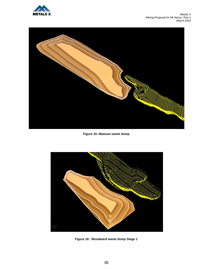
Metals X Mining Proposal for Mt Henry– Part 1
March 2016
38
Figure 15: Mawson waste dump
Figure 16: Woodward waste dump Stage 1

Metals X Mining Proposal for Mt Henry– Part 1
March 2016
39
5.8. WASTE ROCK DUMP PAF MANAGEMENT
The waste dumps have been designed to include a number of separate cells for encapsulation of the
PAF waste material, primarily the BIF, which will be continually be removed over the life of the mine.
The following figures show an encapsulation sequence for the Woodward waste dump. The inert
material is shown in blue with the PAF material in orange. A PAF cell would be open and gradually
encapsulated by inert material progressively throughout mining operations; maximum exposure time
is expected to be 12 months. PAF cell design cover thickness includes minimum 5m coverage
vertically to base or top surface and 10m laterally to any batter face.
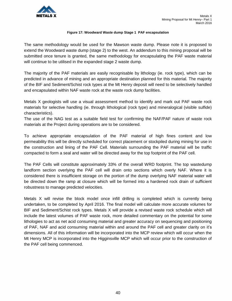
Metals X Mining Proposal for Mt Henry– Part 1
March 2016
40
Figure 17: Woodward Waste dump Stage 1 PAF encapsulation
The same methodology would be used for the Mawson waste dump. Please note it is proposed to
extend the Woodward waste dump (stage 2) to the west. An addendum to this mining proposal will be
submitted once tenure is granted, the same methodology for encapsulating the PAF waste material
will continue to be utilised in the expanded stage 2 waste dump.
The majority of the PAF materials are easily recognisable by lithology (ie. rock type), which can be
predicted in advance of mining and an appropriate destination planned for this material. The majority
of the BIF and Sediment/Schist rock types at the Mt Henry deposit will need to be selectively handled
and encapsulated within NAF waste rock at the waste rock dump facilities.
Metals X geologists will use a visual assessment method to identify and mark out PAF waste rock
materials for selective handling (ie. through lithological (rock type) and mineralogical (visible sulfide)
characteristics).
The use of the NAG test as a suitable field test for confirming the NAF/PAF nature of waste rock
materials at the Project during operations are to be considered.
To achieve appropriate encapsulation of the PAF material of high fines content and low
permeability this will be directly scheduled for correct placement or stockpiled during mining for use in
the construction and lining of the PAF Cell. Materials surrounding the PAF material will be traffic
compacted to form a seal and water will be directed away for the top footprint of the PAF cell.
The PAF Cells will constitute approximately 33% of the overall WRD footprint. The top wastedump
landform section overlying the PAF cell will drain onto sections which overly NAF. Where it is
considered there is insufficient storage on the portion of the dump overlying NAF material water will
be directed down the ramp at closure which will be formed into a hardened rock drain of sufficient
robustness to manage predicted velocities.
Metals X will revise the block model once infill drilling is completed which is currently being
undertaken, to be completed by April 2016. The final model will calculate more accurate volumes for
BIF and Sediment/Schist rock types. Metals X will provide a revised waste rock schedule which will
include the latest volumes of PAF waste rock, more detailed commentary on the potential for some
lithologies to act as net acid consuming material and greater accuracy on sequencing and positioning
of PAF, NAF and acid consuming material within and around the PAF cell and greater clarity on it’s
dimensions. All of this information will be incorporated into the MCP review which will occur when the
Mt Henry MCP is incorporated into the Higginsville MCP which will occur prior to the construction of
the PAF cell being commenced.

Metals X Mining Proposal for Mt Henry– Part 1
March 2016
41
5.9. HYDROCARBON MANAGEMENT
No new or any increases in amounts of hydrocarbons will be used as a result of this proposal.
The Environmental Management Plan attached as Appendix 2 details site hydrocarbon management
within the Waste Management section. All waste hydrocarbons will be removed from site by licenced
controlled waste carriers, for disposal offsite.
Any hydrocarbons stored onsite as will be as per required: Bulk fuel storage will be within double
skinned tanks and smaller drums will be stored within bunded areas that contain 110% of the largest
drum contents and 25% of the total volume of stored liquids together with spill kits.
Figure 18: Example of workshop hydrocarbon containment
5.10. DANGEROUS GOODS AND HAZARDOUS SUBSTANCES
No new or any increases in amounts of dangerous goods will be used as a result of this proposal.
Explosives will be managed by the Higginsville Gold Operations Safety department as per various
acts and regulations. Dangerous Goods and hazardous substances will be outlined in the Safety
Management Plan to be submitted to the DMP Safety division for approval.
5.11. ATMOSPHERIC POLLUTION AND NOISE
Dust will be controlled with the regular use of water trucks around the site and on site roads on an as
required basis.

Metals X Mining Proposal for Mt Henry– Part 1
March 2016
42
Prior to accessing groundwater within the pit for site dust suppression a drainage interception trench
will be dug with an excavator along the edge of Lake Dundas to naturally collect groundwater from
the Lake. The trench will not be lined and is estimated to be up to 50 meters in length. An example of
concept is provided below. This will be regulated by a Groundwater extraction licence from
Department of Water which has been applied for and advertised.
Figure 19: Example of Lake Edge drainage interception trench
As part of the National Pollution Inventory and National Greenhouse Energy Reporting quantities of
air and other emissions will be estimated or measured and reported annually for the Higginsville
Project.
All operations will comply with the noise regulations under the Mines Safety and Inspection Act 1994,
Mines Safety and Inspection Regulations 1995 and the Environmental Protection Act (Noise)
Regulations1997.

Metals X Mining Proposal for Mt Henry– Part 1
March 2016
43
6. SOCIAL IMPACTS
6.1. HERITAGE
A search of the Department of Aboriginal Affairs (DAA) Aboriginal Heritage Inquiry System (AHIS)
indicated that there are no registered aboriginal sites; however there is one heritage place within the
project area. Noganyer Soak (Site 2924). The Site is classified as an ethnographic place with
archaeological artefact/scatters. Metals X has in place an agreement with the Ngadju group over the
area and are currently in progress with an enquiry specifically relating to Site 2924.
The project is located in the Shire of Dundas in Western Australia. This region contains Unallocated
Crown Land and reserves, and is sparsely populated with grazing, fishing, aboriginal heritage,
tourism, exploration and mining being the primary land users. The population of the shire fluctuates;
however in 2013 the population was approximately 1200. The majority of the project is located on
Unallocated Crown Land with small sections of reserves. The Shire of Dundas actively enhances
tourism and the Historic Dundas Townsite is visited by many tourists. The previous tenement owners
and Metals X have been in consultation with the shire regarding its mining plans for the area and will
continue consultation to attain an open and honest relationship. A map attached as Appendix 1
shows the reserves for the area.
6.2. LAND USE AND COMMUNITY
Other Land occupiers within this mining proposal include the Dundas Shire (shire number 3080).
This is the second project Metals X has operated within the Dundas shire, the first project being
Chalice. Higginsville Gold Operations has previously operated harmoniously with the Dundas Shire ,
and understands that this project requires considerable shire consultation which it has commenced.
As part of this consultation, this Mining proposal will be presented to the Shire.
Mt Henry Project area is situated on crown land and not upon any pastoral lease. The nearest
pastoral lease being Madoonia Downs Station, the pastoral boundary is located approximately 70km
from the Mt Henry Project.
6.3. SOCIAL ENVIRONMENT
Higginsville Gold Operations provides a flexible and stable working arrangement with its Higginsville
employees allowing them to be fly in / fly out from Perth or regional drive in / drive out. This supports
local communities such as Norseman, Kambalda, Esperance and Kalgoorlie as well as providing
opportunities to a wide range of local/regional contractors to support the minesite.
The Mt Henry Project is aiming to attract many Norseman locals for its Mt Henry Project, with the aim
to house them within Norseman.

Metals X Mining Proposal for Mt Henry– Part 1
March 2016
44
This proposal will enable continued stability of the benefits Higginsville Gold Operations offers to its
local community. On a broader scale, production from the site contributes to the state economy and
the Australian GDP.
6.4. WORKFORCE INDUCTION AND TRAINING
All of the workforce, both Higginsville Gold Operations staff and contractors, will be given a general
site induction on arrival at the site this includes health, safety and environmental aspects. Every
employee or contractor will be required to complete or maintain a re-induction course every three
years. The initial and repeat induction courses contain a specific section on environmental issues
related to the Higginsville Gold Operations.
A specific Mt Henry Pit induction will be developed targeting the surface mining operations.
Accompanying the induction will be procedures that address safe work practices relating to high risk
work areas identified within the Mt Henry mining project.

Metals X Mining Proposal for Mt Henry– Part 1
March 2016
45
7. MINE CLOSURE
Higginsville Gold Operations has an approved Mine Closure Plan that outlines the detailed closure
objectives, criteria and activities for the following specific areas:
Open Pits/Underground Voids
Surface Waste Dumps
Tailings Storage Facilities
Process Plant
Workshops and Bulk Hydrocarbon Storage
Administration Areas and Camp Facilities
Haulage and Access Roads
Dewatering Pipelines, Water Supply Pipelines & Monitoring Bores
Explosives and Detonator Magazines
This closure plan was developed with the assistance of consultant Rory Haymont from Trajectory and
was aligned to the DMP closure plan guidelines. A copy of this plan can be provided if required, due
to its large size it has not been included as an attachment. The plan covers 4 main project areas of
the Higginsville Gold Operations leases which include:
Project Area 1- Higginsville Mining Area
Project Area 2- Lake Cowan Mining Area
Project Area 3 -Palaeochannel Mining Areas
Project Area 4 -Chalice Mining Areas
Proposed Project Area 5- Mt Henry Mining Area
The Higginsville Gold Operations Mine Closure plan was approved by the Department of Mines and
Petroleum on the 1st November 2013 and is due for resubmission in 2016.
An updated specific mine closure plan has also been documented for Mt Henry, it is Higginsville Gold
Operations proposal to incorporate this closure plan into the Higginsville Site closure plan which is
due for resubmission in 2016. Various knowledge gaps and additional commitments within the plans
and this mining proposal will be included within the new plan.
Specific Closure and Waste Dump / Haul Road Rehabilitation commitments to this Mining Proposal
Include the following: (if approved they will be incorporated into the mine closure plan prior to its
review in 2016)
A Safety Bund wall around Mt Henry Pits will be constructed with fresh rock prior to pit being
closed off and project finished.

Metals X Mining Proposal for Mt Henry– Part 1
March 2016
46
Mt Henry Pit entrances will be bunded, to stop public access to pit once pit mining is
completed.
Mawson and Woodward Waste Dump primary earthworks will be finished during life of project
or within 6 months of Mt Henry Pit mining being completed. Including spreading topsoil, mulch,
contour ripping and seeding of waste dump.
7.1. POST MINING LAND USE
Upon the completion of mining activities the area will return to its vacant crown land use.
7.2. REHABILITATION
Submission of the recently updated Mt Henry Mine closure plan will be forwarded as a separate
document together with this mining proposal.
A general rehabilitation outline for each project component is listed below:
General Closure Implementation Management Actions
Open Pit
Waste Rock Final Landform
Administration Workshop and Infrastructure
Water Management and Drainage Structures
Roads Corridors and Fences
Exploration
7.2.1. GENERAL CLOSURE IMPLEMENTATION MANAGEMENT ACTIONS
In the absence of closure or rehabilitation issues requiring specific actions, the following default
measures will be applied and used to calculate the rehabilitation and closure costs. There are
essentially three activities associated with site closure:
Demolition- All permanent structures will be dismantled or demolished and removed to a depth of at
least one metre. Recoverable materials may be sold if a suitable market can be found at the time of
decommissioning. All inert rubble and materials resulting from the demolition exercise which
cannot be re-used will be disposed within the designated closure landfill facility for the Project. During
operation, all of the Mt Henry’s domestic waste (landfill) will be collected and disposed of within the
Higginsville Gold Operations landfill facility or the Norseman town landfill facility, if Metals X
obtains necessary approval from The Norseman Shire. Hazardous wastes will be disposed at
appropriately licensed facilities off site.
All surface pipelines, power cables/lines and security fences will be removed and materials will be
sold, re-used or otherwise disposed within the closure landfill facility.
Sub-surface pipelines will remain if they cannot be economically salvaged, but will be appropriately
drained, flushed and sealed (crimped or capped). Plastic pond liners will be cut, folded and

Metals X Mining Proposal for Mt Henry– Part 1
March 2016
47
buried in situ for below-ground ponds or removed to the disposal site for above ground ponds.
Clean up and Remediation The largest hazardous material (by volume) required on the site will
be diesel, used for mining equipment and vehicles. At closure, remaining chemicals and
hydrocarbons will be returned to the supplier or sold to a third party. Waste chemicals,
hydrocarbons and contaminated materials will be removed offsite for disposal at a licensed facility
or remediated on site prior to disposal on site. Remaining rubbish will be removed and
disposed within the inert landfill as per existing procedures.
Rehabilitation and Revegetation Following demolition of infrastructure and site clean-up, the
remaining disturbed sites will be regraded to re-establish pre-existing drainage lines.
During operations, topsoil up to 100 – 400mm mm thick will be stripped from available sites and
stockpiled. Stockpiles will be a maximum of two metres high and be located in water shedding
sites, to prevent localised flooding/inundation. Topsoil will be directly returned progressively to
rehabilitated landforms during waste rock landform construction if this is feasible. Weed
management of Topsoil Stockpiles and vegetation debris occurs as required to reduce the potential
spread of weeds into rehabilitated areas.
During rehabilitation, previously stockpiled topsoil will be respread at between 100mm and 150mm
deep and ripped to a depth of 500mm to 1m along the contour to reduce compaction and ensure
cohesion between the topsoil, the and the disturbed land surface. Ripping will also provide niches
where water, organic matter and seed can collect.
Seeding with native shrubs and tree seeds will be conducted to supplement the seed source within
the topsoil, the respread vegetation and adjacent native vegetation. The species selected for
the revegetation programme will depend on the site-specific conditions (e.g. slope, drainage, soil
conditions).
7.2.2. OPEN PIT
The Mt Henry open pit will not be refilled and will remain a permanent feature; An abandonment bund
will be in place, in compliance with the DMP Guideline to discourage access.

Metals X Mining Proposal for Mt Henry– Part 1
March 2016
48
Figure 20: Abandonment Bund Wall Guideline
7.2.3. WASTE ROCK FINAL LANDFORM
Exactly as per Section 5.7 within this Mining Proposal.
Earthworks Construction, Dumping will be carried out such that the configuration is realised and
depths of competent waste, batter angles and berm widths are achieved as specified.
PAF, Any potentially acid forming material produced by the Project will be managed to minimise
the potential for the production of acid runoff or leachate, and minimise the potential effects on the
receiving environment should localized acid generation occur.
PAF material present as ore will be stockpiled on the ore pads for a minimal amount of time prior to
being processed at the proposed Higginsville processing facilities. A waste rock characterisation
sampling program will be implemented throughout the life of the Project. This program will
ensure accurate identification and disposal requirements of the waste material.
The waste dumps have been designed to include a number of separate cells for encapsulation
of the PAF waste material, primarily the BIF, which will be continually be removed over the life
of the mine. Where practicable acid consuming waste will be placed around and above cells during
their construction.
Revegetation, The revegetation of all landforms has the overall objective of creating surface
conditions conducive to the establishment and survival of self-sustaining vegetation that is native to
the region. Revegetation is achieved by the respreading of topsoil with its bank of native seed, and
by deep ripping of the topsoil and subsoil to promote a rough surface suitable for the
establishment of seedlings and for enhancing infiltration of water. Where necessary, the
establishment of vegetation will be assisted by seeding species which are common in the area

Metals X Mining Proposal for Mt Henry– Part 1
March 2016
49
and which are known to establish readily.
Seeding rates have been designed to reflect the surrounding natural bush with regards to species
composition. Seed rate is 10kg/ha.
All seed that is collected for use in rehabilitation is tested for viability by specialist contractors.
Seeds are cleaned and free of debris and as appropriate may be treated by exposure to
smoked water or mechanical scarification for hard coated seeds to encourage germination.
7.2.4. ADMINISTRATION, WORKSHOP AND INFRASTRUCTURE
All infrastructure including utility services, and office buildings, will be removed at the end of
operations. Power, water bores and septic systems will be shut down and all buildings will be
removed from site. Any inert scrap which is not suitable for re-use or recycling will be buried on
site.
Remediation will be undertaken of any soil contaminated by hydrocarbons or effluent to prevent
impacts on the surrounding environment. Workshops and supporting facilities will be
decommissioned when they are no longer required by the Project.
It is anticipated that most of the Project’s infrastructure and facilities will be sold and/or
relocated to other sites. Other infrastructure not suitable for recycling, reuse or salvage will be
buried onsite. Where infrastructure has been removed, the sites will be recontoured, topsoiled,
ripped and seeded where necessary.
The workshop shed and service equipment will be dismantled, removed and service equipment
sold. The concrete pads established for the workshop, wash bays, stores etc. will be excavated and
for later re-use, or buried on-site. All inert scrap material and parts not suitable for re-use or
recycling will be either buried or taken off-site for appropriate disposal.
The diesel fuel and lubricant storage tanks that are self-bunded will be transported off site and
sold. To prevent contamination, any hydrocarbons in the base of bunds or sumps will be pumped out
prior to removal, for disposal off-site to a licenced waste provider. Any hydrocarbon-contaminated
soil will be removed prior to revegetation activities taking place and taken to the bioremediation
area.
7.2.5. WATER MANAGEMENT AND DRAINAGE STRUCTURES
All earth drains will be backfilled by dozing loose earth from the immediately adjacent area into the
drains and providing for an approximately 30% overfill to allow for settlement. Cross berms,
consisting of 0.5 m high lightly compacted earth walls will be provided at appropriate intervals (50 m
intervals allowed for) in order to divert any rainfall runoff water that may be channelled by the back
filled drains.
Waste water treatment facilities will be removed and any contaminated material treated
according to relevant guidelines.
The septic treatment system and waste water will be decommissioned by licensed personnel and
removed off-site for disposal at an approved facility by a licensed operator or in the case of
infrastructure reuse or recycling, where permitted.

Metals X Mining Proposal for Mt Henry– Part 1
March 2016
50
7.2.6. ROADS, CORRIDORS AND FENCES
The haul road will be rehabilitated, unless the Stakeholder requests and approvals are sought.
Access tracks for monitoring purposes will remain as required.
7.2.7. EXPLORATION
The following rehabilitation process will be undertaken for exploration pads and tracks:
Remove and dispose of drill spoil appropriately;
Conduct earthworks as required to correct current erosion, remove drill pad sumps and
rectify vehicle tyre ruts on access tracks;
Remove rubbish, including sample bags;
Scrape windrows of rocks back over drill pads and access track;
Re-spread topsoil and removed vegetation over tracks and drill pads (where possible avoiding
damage to plants that have naturally established);
Seed and/or plant with species from the adjacent vegetation and those identified
recruiting naturally to the area (if required);
Where practicable, seeding to be conducted just prior to the onset of forecast wet weather;
Prevent access into the rehabilitated areas;
Annually assess rehabilitation success.
Scarification or ripping of drill pads and access tracks to encourage revegetation and limit
access. Main drill access base lines will remain open unless a stakeholder requests otherwise.
7.3. STRATEGIC FRAMEWORK FOR MINE CLOSURE
The objective of the Mine Closure Plan at Higginsville is to rehabilitate affected areas to produce safe,
stable and non polluting landforms. To ensure that soil erosion and subsequent sedimentation is
minimised and that endemic plant species are re-established to a self sustaining complex into which
local fauna will be able to return and re-establish.
Further objectives of this plan are recommended by the Australian and New Zealand Minerals and
Energy Council (ANZMEC), strategic Framework for Mine Closure (2000) include:
To enable all stakeholders to have their interests considered during the mine closure process;
To ensure the process of closure occurs in an orderly, cost effective and timely manner;
To ensure there is clear accountability, and adequate resources, for the implementation of the
closure plan; and
To establish a set of indicators that will demonstrate the successful completion of the closure
process..
Metals X Mining Proposal for Mt Henry– Part 1
March 2016
51
7.4. SUBMISSION OF MINE CLOSURE PLAN DOCUMENTS
Submission of the recently updated Mt Henry Mine closure plan will be forwarded as a separate
document together with this mining proposal.
It is Higginsville Gold Operations proposal to incorporate this Mt Henry Mine closure plan into the
approved Higginsville Site closure plan which is due for resubmission in 2016. Various knowledge
gaps and additional commitments within the plans and this mining proposal will be included within the
new plan.
As previously stated a copy of the Higginsville Gold Operations Mine Closure Plan can be provided if
required, due to its large size, it has not been included as an attachment but can be made available
upon request.