mineralogy of the surficial sediments of kavala bay, northern aegean sea
TRANSCRIPT
Estuarine, Coastal and Shelf Science (1986) 23,739-749
Mineralogy of the Surficial Sediments of Kavala Bay, Northern Aegean Sea
N. Conispoliatis” and V. Lylcousisb “Geological Sciences, National Technical University and bDepartment of Marine Geology and Geophysics, National Centre for Marine Research, Athens, Greece
Received 20 March 1985 and in revised form 5 March 1986
Keywords: mineral deposits; sand mineralogy; clay mineralogy; Aegean sea
Sand and clay fraction mineralogy of surflcial sediments from Kavala Bay have been determined microscopically and by X-ray diffraction analysis, respectively.
The main minerals present in the sand fraction are quartz, feldspar, micas, amphiboles, and pyroxenes. Biogenic carbonate was also detected especially in the sands of the western part of the bay.
Illite and smectite, are the major clay-mineral phases, with minor amounts of
chlorite and kaolinite in all the samples analysed. Most of the sand appears to have been reworked from abandoned mouths of an
adjacent river (the Nestos) and some has been eroded directly from adjacent land areas. Clay minerals originate from suspensates at the same river and, to a lesser extent, from local and seasonal rivers.
Water circulation and size sorting by the near bottom currents are the mechanisms controlling the clay mineral dispersal within the bay.
Introduction
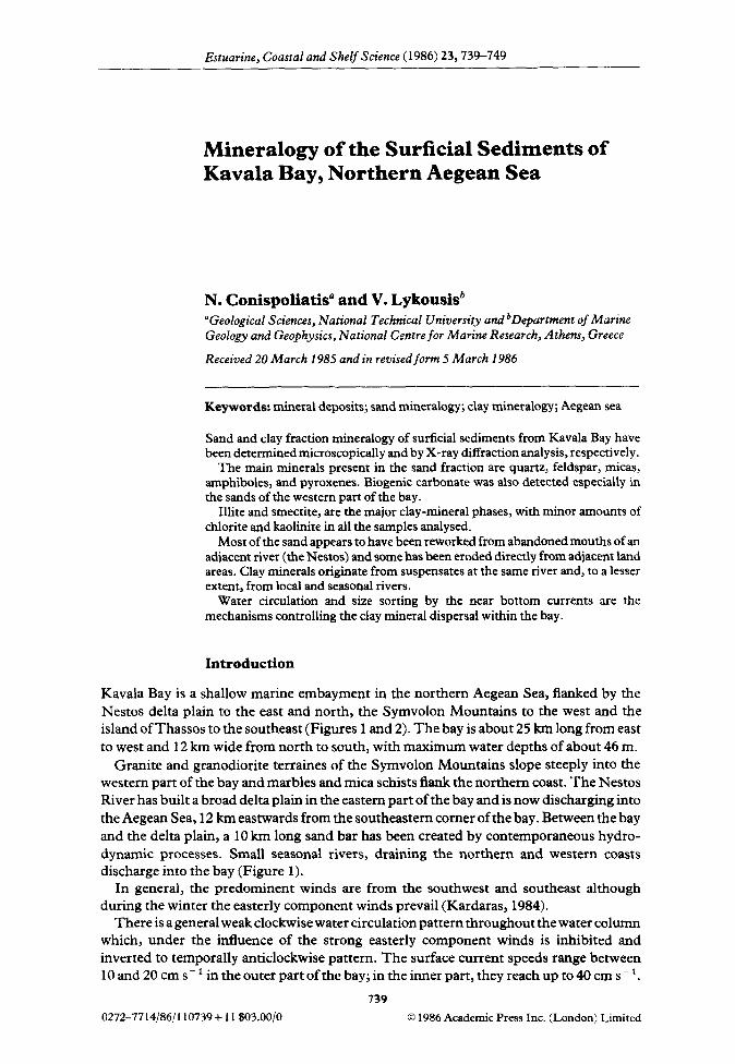
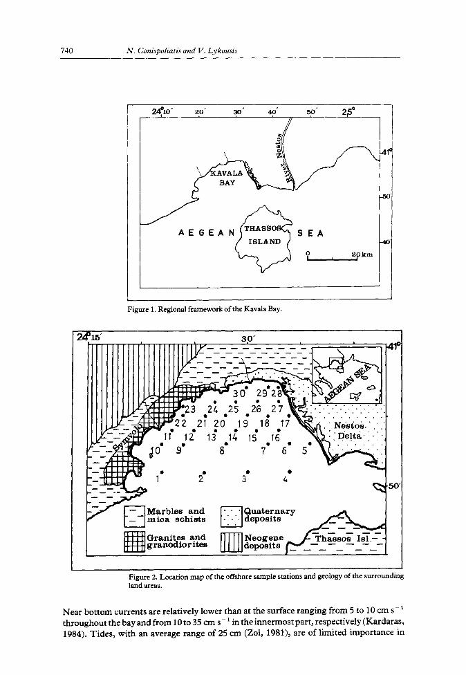
Kavala Bay is a shallow marine embayment in the northern Aegean Sea, flanked by the Nestos delta plain to the east and north, the Symvolon Mountains to the west and the island of Thassos to the southeast (Figures 1 and 2). The bay is about 25 km long from east to west and 12 km wide from north to south, with maximum water depths of about 46 m.
Granite and granodiorite terraines of the Symvolon Mountains slope steeply into the western part of the bay and marbles and mica schists flank the northern coast. The Nestos River has built a broad delta plain in the eastern part of the bay and is now discharging into the Aegean Sea, 12 km eastwards from the southeastern comer of the bay. Between the bay and the delta plain, a 10 km long sand bar has been created by contemporaneous hydro- dynamic processes. Small seasonal rivers, draining the northern and western coasts discharge into the bay (Figure 1).
In general, the predominent winds are from the southwest and southeast although during the winter the easterly component winds prevail (Kardaras, 1984).
There is a general weak clockwise water circulation pattern throughout the water column which, under the influence of the strong easterly component winds is inhibited and inverted to temporally anticlockwise pattern. The surface current speeds range between lOand20cms-’ in the outer part of the bay; in the inner part, they reach up to 40 cm s- ’ .
739
0272--7714/86/l 10739+ 11$03.00/O 0 1986 Academic Press Inc. (London) Limited
740 N. Conispoliatis and V. Lykousis
Figure 1. Regional framework of the Kavala Bay.
24%’ t-an’ ~IIIIIIIII’IIIIIIIIIII’I~
-- ---------c
922 2i 20 19
16
/ Mmica schists 1:::: cl
Granites and granodior it.es •Inl
Figure 2. Location map of the offshore sample stations and geology of the surrounding land areas.
Near bottom currents are relatively lower than at the surface ranging from 5 to 10 cm s - ’ throughout the bay and from 10 to 35 cm s - 1 in the innermost part, respectively (Kardaras,
1984). Tides, with an average range of 25 cm (Zoi, 1981), are of limited importance in
Mineralogy of surficial sediments 741
controlling water movements. Sediments of the bay are composed mainly of mud-grade material (Figure 3), with terrigenous coarse silt and fine sand relatively increasing towards the eastern and southeastern part of the bay (Lykousis, 1984). Biogenic coarse material predominates in the muddy sands and the sandy muds within the central and southwestern area.
The purpose of this study is to determine the distribution and deduce the sources of the main minerals present in the sand and the clay fractions of the sediments of Kavala Bay. Mechanisms of sand and clay dispersal are also discussed.
Methods
Thirty sediment samples were collected from the sea-bed of Kavala Bay (Figure 2), using a Van Veen grab. Grainsize analyses were made on all the samples using sieving and pipette analysis techniques (Folk, 1974).
Standard petrographic techniques were used to identify mineral grains of all sizes in the sand fraction; at least 300 grains in each sample were counted. The various minerals were grouped into six compositional classes: (1) quartz-feldspar, (2) micas, (3) amphiboles, (4) pyroxenes, (5) biogenic carbonate and (6) ‘others’ (all other minerals).
X-ray diffraction analysis was performed on the clay < 2 urn fraction of all the samples. A smear-on-glass slide technique (Gibbs, 1971) was used for the preparation of oriented clay samples for X-ray diffraction analysis. The analysis were carried out on a powder diffractometer using nickel-filtered Cu-Ka radiation. The identification of clay minerals involved the standard pretreatments of glyceration and heating at 450 “C. The clay minerals observed in the present study, namely, Kaolinite, chlorite, smectite and illite, were identified by their characteristic basal-reflection maxima (or peaks). Small quantities of mixed-layer minerals also were occasionally observed. The semi-quantitative estimates of the relative amounts of clay minerals were calculated using the method of Biscaye (1965).
Results and discussion
The mineralogical analyses of the sand and the clay fraction of the surficial sediments of the bay are listed in Table 1 and illustrated in Figures 4-10.
Sand fraction mineralogy Quartz-feldspar is the predominant mineralogical group, ranging between 25 and 65Ob; it accounts for more than 50% of the grains identified in most samples. The higher concen- trations ( > 60%) are confined mainly along the eastern coastline of the bay, including the delta-front of the Nestos and decreasing towards the west (Figure 4). The distribution suggests that these sands were deposited at the river mouths during construction of the Nestos delta and then reworked, from the abandoned mouths by waves and longshore currents.
Micas including biotite, muscovite and, to a lesser extent, chlorite vary from 3 to 2341, and are concentrated (> 20%) in the shallow water areas; these are mainly along the eastern coastline, especially to the southeast and northeast and decrease in abundance towards the centre and southwest of the bay (Figure 5). The distribution is indicative of a major mica source from the reworking of the abandoned river mouths. Potential mica

41:
55:
sol-
/
2410
' 2’
5’
3.0’
35
40
'
Figu
re
3. G
rain-
size
dist
ribut
ion
acco
rdin
g to
th
e Fo
lk (1
974)
cl
assi
ficat
ion.

Minerabgy of surficial sediments 743
QUARTZ - FELDSPAR(%)
Figure 4. Percentage of quartz-feldspar in the sand fractions of the surficial sediments.
MICA (%)
Figure 5. Percentage of mica in the sand fractions of the surficial sediments.

744 N. Conispoliatis and V. Lykousis
AMPHIBOLE (-/.)
Figure 6. Percentage of amphibole in the sand fractions of the surficial sediments.
sources could be the River Nestos. Material is transported from the southeast and, to a lesser extent, from the exposed granitic rocks of the western coastline.
Minerals in the amphibole group are primarily hornblende and actinolite, which comprises 0 to loo/, of the sand fraction. The highest amphibole concentration (> 8%) is found in the sands of the prodelta area of the inactive western Nestos delta (Figure 6). The high amphibole concentration in this area, combined with the high amphibole content of the Nestos River [69% of the non-opaque heavy fraction (Pe and Panagos, 1979)], reflects the important role played by the Nestos delta in suppling elastic sands to the bay.
Minerals in thepyroxene group are found in low concentrations (O-39/,) throughout the bay and consist mainly of diopside and augite.
Biogenic carbonate (2-56%) consisting mostly of shells and shell fragments are most highly concentrated (up to 567;) in the western part of the bay (Figure 7). The presence of a spectrum of shell-fragment sizes indicates that the shell sands are being produced locally, from modern marine skeletal production. The lowest concentration of biogenic material is found at the eastern part of the bay, suggesting that detrital supply must dominate here.
Clay mineralogy
Illite, smectite, chlorite and kaolinite were detected in different amounts, in the surficial sediments from Kavala Bay. The clay mineral percentages are presented in Table 1.
Illite is the most abundant clay mineral within the study area, varying from 64% to 76.5% _ The surface distribution of illite shows that high values (> 70%) prevail in the

Mineralogy of surfkial sediments 745
Figure 7. Percentage of biogenic carbonate in the sand fractions of the surficial sediments.
central, southern and southwestern part of the bay, as well as along the northern coastline (Figure 8). Relatively lower values (64-700/b) appear in the eastern and western part of the bay and higher values (74%-76.5%) in the north. The small seasonal rivers which drain the granites and marbles, together with the coastal erosion of the beach sands, does not seem to contribute significantly to the high amounts of illite found. The illite could derive from the drainage area of the Nestos River, which drains terrains rich in muscovite (I.G.M.E., 1954). These terrains provide high amounts of clay in the river suspensates. The illitic suspended sediment appears then to be transported west apparently by water circulation and then distributed into the bay by the relatively weak near bottom currents. The high values of illite found in the south and southeast support the assumption that illite is derived from the River Nestos suspensates. High values in the northern part of the bay are due probably to the small seasonal rivers from the north, that drain partly mica-schists and gneiss.
The distribution of smectite (Figure 9) is generally in inverse proportion to that of illite, with concentrations ranging from 776 to 27.5O/&. Relatively high values (> 14O,,) were found in the areas of relatively low illite values (60-700/,) in a semicircular trend. The lower values (< loo&) were observed in the innermost part of the bay. Relatively low values (lO--149,,) were found in the northern, central and south-southwestern part of the area.
The generally low values of smectite found in the bay are due possibly to the absence of volcanic activity or the alteration of volcanic materials in the wider area. Because of the intergradation of terrigenous and authigenic smectite, the distribution pattern of Figure 9 reflects dilution of smectite mainly by illite, which is due to physical sorting by size rather

TABL
E 1.
Mine
ralog
y of
the
su
rfici
al
sedi
men
ts
Sand
fra
ctio
n (>
0.
063
mm
) Cl
ay
fract
ion
( c:
2 u
rn)
Stll
No
Wat
er
dept
h
(4
Qua
rtz-fe
ld.
(%I
Mica
s (%
) Am
phib
oles
Py
roxe
nes
Biog
enic
Oth
ers
Illite
Sm
ectit
e Ch
lorit
e Ka
olin
ite
(%I
(%)
(%)
(%I
WI)
(%)
(%)
(“/o)
1 38
44
4
2 3
35
12
68
14
1.5
16.5
2
42
42
3 2
2 37
14
70
10
6.
5 13
.5
3 42
55
16
3
- 18
8
70.5
11
.5
6.5
12.5
4
35
63
6 3
2 13
13
70
13
7
10
5 24
62
22
8
3 2
3 70
14
.5
5.2
10.3
6
31
60
16
4 2
10
11
68
15
3.8
13.2
7
35
57
13
3 1
11
15
68
14
5.7
12.3
8
35
53
6 3
2 21
15
70
.5
20
5 4
9 38
50
12
2
1 28
7
68
21
7 4
10
35
40
15
3 2
35
5 67
17
1.
5 14
.5
11
33
42
14
3 2
34
5 67
.7
14.5
6.
1 11
.7
12
37
51
10
2 -
31
6 64
17
5.
7 13
.3
13
35
64
9 1
- 10
16
68
18
3
II 14
35
54
7
1 1
24
13
72
12
1.6
14.4
15
32
56
9
2 1
20
12
65.2
14
.9
7.9
11.9
16
30
59
18
2
2 12
7
67.5
13
3.
1 16
.4
17
18
62
22
10
3 3
- 65
.5
20.5
1.
5 12
.5
18
27
60
17
3 2
9 7
68.5
13
.6
5.7
12.1
19
30
54
5
2 1
23
15
63.5
27
.5
3.6
5.4
20
32
54
12
3 1
17
13
64
26
3.8
6.2
21
32
53
17
2 2
18
8 64
15
.2
4.6
16.2
22
29
50
21
6
3 18
2
75
11
4 10
23
20
25
3
4 2
56
10
76
13
2 9
24
23
58
20
5 2
12
3 74
13
1.
1 11
.9
25
26
57
11
3 2
14
13
68
14.8
6.
2 11
26
24
63
22
2
1 8
4 69
13
4
14
27
20
65
23
5 2
5 -
68.5
12
.8
4.5
14.2
28
15
61
22
6
3 2
6 73
8
4 15
29
12
63
20
7
3 4
3 71
10
4.
5 14
.5
30
10
57
23
6 2
11
1 76
-5
7 12
.4
4.1

-- Mineralogy of surficial sediments 747
2
Figure 8. Percentage of illite in the clay fractions of the surficial sediments.
2
Figure 9. Percentage of smectite in the clay fractions of the surficial sediments.

748 N. Conispoliatis and V. Lykousis
24’1s ’ 30’
CHLORITE (-/)
Figure 10. Percentage of chlorite in the clay fractions of the surticial sediments.
than by chemical alteration or differential flocculation. A similar case was reported by Gibbs (1977) for the clay mineral facies off the mouth of the Amazon River where the progressive increase in smectite and decrease in illite was due to physical sorting by size. This is more prominent in the innermost part of the bay (north-western coastline), where low smectite values are attributed to the relatively strong longshore currents. These currents are responsible for the size sorting, winnowing away the finer smectite relatively to illite and, possibly, chlorite.
The surface distribution of chlorite (Figure IO) shows that relatively low values (5-109;) occur in the southern and southeastern and in two tongue-like projections to the northwest and northeast. Low values ( < 5 Oh) were observed in the north, northeastern and southwes- tern part of the bay. Higher values (6.2%, 12.4%) were found in the innermost part. The distribution of chlorite could indicate either that the deposition of chlorite is overcovered by illite or that it is limited input of chlorite from the surrounding land, through the various seasonal rivers. Although the latter is more possible, it is believed that limited input of chlorite and dillution by illite are responsible for the distribution of chlorite in the bay. The relatively higher values observed in the innermost part of the bay seems to be the result of selective size sorting among the clay minerals, by the longshore currents. Chlorite is dense and tends to be coarse-grained, so the sorting by currents acts as a selective agent, thereby enriching chlorite relatively to smectite.
Kuolinite constitutes from 5.4% to 16.5 y. of the fine fractions and its distribution does not vary significantly within the bay. The higher values ( > 139/,) were found in the western part implying a direct local source from the seasonal rivers which drain the granites and granodiorites of the Symvolon Mountains in the western mainland. High

MineraIogy ofsurficial sedimenrs 749
values (Z 13°,0) were found, as well, in the eastern part of the bay along the eastern coastline. Kaolinite in this part of the bay is possibly due to the coastal erosion by waves.
The distribution of illite, smectite, chlorite and Kaolinite in Kavala Bay, suggests that there is a correllation between the River Nestos suspensates and the general water masses circulation. Works in the Gulf of Mexico (Griffin, 1962), the Eastern Mediteranean sea (Venkatarathnam & Ryam, 1971; Shaw, 1978) and the Sea of Japan (Saburo et al., 1974) have demonstrated similar correlations between marine clay mineral distribution and specific currents and river discharges.
Conclusions
The mineral characteristics of the sand and clay fractions of the surface sediments of the Kavala Bay can be explained as being derived from the Nestos delta and local source areas. In particular, sands in the eastern part of the bay are rich in quartz, feldspar, micas and amphiboles, suggesting that they are reworked from the abandoned Nestos River mouths, by waves and long-shore currents. This mechanism does not preclude transport of very fine sands from the Nestos freshwater plume, from the southeast. Such a source of sands is of limited importance when compared to those active within the bay. There is little evidence of a significant input of sands from the granites of the northern and western coast; this is supported by the high concentration of biogenic carbonate in the western part of the bay.
The limited input of fine-grained material from the small seasonal rivers together with concentrations of illite in the southeastern part of the bay and the prevailing hydrodynamic regime, imply that the predominant source of clay minerals (mainly illite) is the River Nestos suspensate supply. From the distribution of clay minerals, it appears that the mechanisms controlling the clay mineral dispersal are the general water circulation within the bay and the size sorting by the near-bottom currents; these are especially pronounced in the innermost part of the bay.
References Biscaye, E. P. 1965 Mineralogy and sedimentation of recent deep-sea clay in the Atlantic Ocean and adjacent
seas and Oceans. Geological Society of America Bulletin 76,803-832. Folk, R. L. 1974 Petrology of Sedimenttary Rocks. Henphill Publishing Co., Austin, Texas. Gibbs, R. J. 1971 X-ray diffraction mounts. In: Procedures in Sedimentary Petrology Carver, R. E. ed.). John
Wiley and Sons, New York. pp. 531-539. Gibbs, R. J. 1977 Clay mineral segregation in the marine environment. Journal of Sedimentary Petrology 47,
231-342. Griffin, M. G. 1962 Regional clay-mineral facies-products of weathering intensity and current distribution
in the northeastern Gulf of Mexico. Geological Society of American Bulletin 73,737-768. I.G.M.E. 1954 Geological map of Greece. Kardaras, T. 1984 Water circulation and currents in Kavala Bay. 1st Symp. of Ocean. and Fish. I.O.K.A.E.
(in press). Lykousis,V. 1984ModernsedimentationinKavalaBay. 1st Symp. ofocean. andFish. I.O.K.A.E. (in press!. Pe, G. G. & Panagos, A. G. 1979 Heavy mineralogy of river and beach sands, continental Greece. N. Jb.
Miner. Abh. 136(3), 254-261. Saburo, A., Kaoru, 0. & Toshio, S., 1974 The distribution of clay minerals in the recent sediments of the
Japan Sea. Deep-Sea Research 21,299-310. Shaw, F. H. 1978 The clay mineralogy of the recent surface sediments from the Cilicia Basin, Northeastern
Mediterranean. Marine Geology 26, M51-M58. Venkatarathnam, K. & Ryan, F. B. 1971 Dispersal patterns of clay minerals in the sediments of the Eastern
Mediterranean Sea. Marine Geology 11,261-282. Zoi, A. 1981 Tidal elements of Greek harbors (in Greek). Hydrographic Service of the Greek Navy, Athens.