mineral exploration for gold and base metals in the
TRANSCRIPT

British Geological Survey
Mineral Reconnaissance Programme
Mineral exploration for gold
and base metals in the
Lewisian and associated
rocks of the Glenelg ares
north-west Scotland
Department of Trade and Industry


MRP Report 140
Mineral exploration for gold and base metals in the Lewisian and associated rocks of the Glenelg area, north-west Scotland
J S Coats, M H Shaw, R T Smith, K E Rollin, C G Smith and N J Fortey


BRITISH GEOLOGICAL SURVEY
Mineral Reconnaissance Programme Report 140
Mineral exploration for gold and base metals in the Lewisian and associated rocks of the Glenelg area, north-west Scotland
J S Coats, M H Shaw, R T Smith, K E Rollin, C G Smith and N J Fortey
Geochemistry
J S Coats, BSc, PhD M H Shaw, BSc R T Smith, BSc, MSc
Geophysics
K E Rollin, BSc
Geology
C G Smith
Mineralogy
N J Fortey, BSc, PhD
This report was prepared for the Department of Trade and Industry
Maps and diagrams in this report use topography based on Ordnance Survey mapping
Bibliographical reference
J S Coats, M H Shaw, R T Smith, K E Rollin, C G Smith and N J Fortey. 1996 Mineral exploration for gold and base metals in the Lewisian and associated rocks of the Glenelg area, north-west Scotland. Mineral Reconnaissance Programme Report, British Geological Survey, No. 140.
0 NERC copyright 1996 Keyworth, Nottingham 1996

The full range of Survey publications is available from the BGS Keyworth, Nottingham NG 12 5GG Sales Desk at the Survey headquarters, Keyworth, Nottingham. The = 0115936 3100 Telex 378 173 BGSKEY G
more popular maps and books may be purchased from BGS- Fax 0115936 3200 approved stockists and agents and over the counter at the Bookshop, Gallery 37, Natural History Museum, Cromwell Road, (Earth Galleries), London. Sales Desks are also located at the BGS
Murchison House, West Mains Road, Edinburgh, EH9 3LA
London Information Office, and at Murchison House, Edinburgh. = 0131-667 1000 Telex 727343 SEISED G
The London Information Office maintains a reference collection of Fax0131-6682683
BGS publications including maps for consultation. Some BGS books and reports may also be obtained from HMSO Publications Centre or from HMSO bookshops and agents.
London Information Office at the Natural History Museum, Earth Galleries, Exhibition Road, South Kensington, London, SW7 2DE
The Survey publishes an annual catalogue of maps, which lists = 0171-589 4090
published material and contains index maps for several of the BGS * 0171-938 9056/57 Fax 0171-584 8270
series. 19 Grange Terrace, Edinburgh EH9 2LF
e 0131-667 1000 Telex 727343 SEISED G
The British Geological Survey carries out the geological survqy of Great Britain and Northern Ireland (the latter as an agency service St Just, 30 Pennsylvania Road, Exeter EX4 6BX for the government of Northern Ireland), and of the surrounding = 01392-78312 Fax 0 1392-437505 continental shelf, as well as its basic research projects. It also undertakes programmes of British technical aid in geology in Geological Survey of Northern Ireland, 20 College Gardens, developing countries as arranged by the Overseas Development Belfast BT9 6BS Administration. = 0 1232-666595 Fax 0 1232-662835
The British Geological Survey is a component body of the Natural Environment Research Council.
Maclean Building, Crowmarsh Gifford, Wallingford, Oxfordshire OX 10 8BB
= 01491-838800 Telex 849365 HYDROL G
Fax 01491-25338
Parent Body
Natural Environment Research Council Polaris House, North Star Avenue, Swindon, Wiltshire SN2 IEU = 01793-411500 Telex 444293 ENVRE G
Fax 01793-411501
This report relates to work carried out by the British Geological Survey on behalf of the Department of Trade and Industry. The information contained herein must not be published without reference to the Director, British Geological Survey.
Dr D C Cooper Minerals Group British Geological Survey Keyworth Nottingham NG 12 5GG
Printed in England for the British Geological
Saxon Graphics Limited, Derby.
Survey by

SUMMARY
INTRODUCTION
Physiography
General geology
Mineralisation
REGIONAL GEOCHEMISTRY 8
Stream sediments 8
Panned concentrates 27
DETAILED INVESTIGATIONS OF THE CARR BRAE AREA
Overburden geochemistry
Geophysics
Detailed geology
Mineralisation
Lithogeochemistry
41
41
45
51
57
57
LITHOGEOCHEMISTRY OF THE EASTERN LEWISIAN
Eulysites
Pyrite-bearing talc-silicate rocks
Graphite-bearing gneiss
RATAGAIN IGNEOUS COMPLEX 69
CONCLUSIONS
REFERENCES 72
59
59
64
66
71
TABLES
1 Summary statistics for stream sediment samples from the Glenelg area 10
2 Comparison of stream sediment compositions with the Great Glen Geochemical Atlas
(British Geological Survey, 1987) 11
3 Summary statistics for panned concentrate samples from the Glenelg area 29
4 Summary statistics for shallow overburden samples from the Car-r Brae area 41
5 Mean susceptibility values in SI x lo3 for selected formations in the Glenelg area 47
6 Geological section of Allt a’ Mhuilinn between [19008 824491 and [ 19014 824541 53
7 Composite geological section of crags between [ 19004 824621 and [ 19017 824571 54

8
9
10
11
12
Comparison of median composition of eulysites from the project area with those of quartz-
magnetite schists (QMS) from Gairloch and average compositions of banded ironstones
from Canada
Summary statistics for the talc-silicate gneiss samples
Summary statistics for samples of graphitic gneiss
Total carbon and sulphur contents of graphitic gneisses
Comparison of gold and base metal contents of veins in the Ratagain complex and the
Moine and Lewisian country rocks
FIGURES
1 Location map of Scotland showing the Glenelg-Loch Duich, Gairloch, Loch Maree and
Scardroy project areas 3
2
3
Schematic geology of the Loch Carron to Glenelg area. (Rocks south of the Strathconon
fault and north of Loch Carron are left blank)
Geological map of the Eastern Lewisian north-east of Loch Duich (after May et al., 1993)
Distribution of titanium in stream sediments
5
6
4 9
5 Distribution of cobalt in stream sediments 12
6 Distribution of nickel in stream sediments 14
7
8
Distribution of copper in stream sediments
Distribution of zinc in stream sediments
15
16
9 Distribution of arsenic in stream sediments 18
10 Distribution of silver in stream sediments 20
11 Distribution of barium in stream sediments 21
12 Distribution of lanthanum in stream sediments 22
13 Distribution of cerium in stream sediments 23
14 Distribution of gold in stream sediments
Distribution of lead in stream sediments
25
15 26
16 Distribution of titanium in panned concentrates 28
17 Distribution of nickel in mumed concentrates 32
63
65
66
69
70

18
19
20
21
22
23
24
25
26
27
28
29
30a
30b
31
32
33
34
35
Distribution of copper in panned concentrates
Distribution of zinc in panned concentrates
Distribution of barium in panned concentrates
Distribution of gold in panned concentrates
Plot of Cu vs Fe for shallow overburden samples, Carr Brae
Distribution of manganese in shallow overburden, Carr Brae
Distribution of copper in shallow overburden, Carr Brae
Total-field magnetic data at Carr Brae. Anomalies are corrected for diurnal change and
plotted relative to 49700 nT. Ey is the mapped eulysite.
Histogram of site mean susceptibility data from 113 sites for Eastern facies Lewisian in
the Carr Brae area, north of Loch Duich. Histogram truncated at 0.06 SI and most of the
population above this level are eulysites with susceptibities above 0.1 SI.
Site susceptibility data (geometric mean values posted along geophysical lines), Carr Brae.
Data truncated at 0.2 SI.
34
35
37
39
42
43
44
46
48
49
VLF data, Carr Brae. VLF Magnetic-field data for GB Rugby 16.OkHz. In-phase component
data shaded, out-of-phase component shown as a solid line. 50
Detailed geology of the Carr Brae area 52
Geology of the eulysite locality at Loch na Folaig [19028 825351 56
Geology of the eulysite locality at Loch a’ Mhuilinn [ 19047 825191 56
Variation of Ca, Ti, V, Mn, Fe, Ni, Cu and Zn across the lithogeochemistry traverse, Carr
Brae. Samples KLR 3835,3837 and 3841 are quartz-feldspar (-mica) gneiss, KLR 3839 is
a coarse garnet-quartz rock, and samples KLR 3843 and 3845 are eulysites 58
Location of eulysite samples in the Eastern Lewisian 60
Variation of Fe/Ti vs Mn in the lithogeochemistry samples 62
Location of graphite gneiss samples in the Eastern Lewisian 67
Comparison of Glenelg graphitic gneiss, Keretti black schists (Loukola-Ruskeeniemi 1992),
and average black shale (Vine and Tourtelot 1970), normalised to Taylor and MacLennan’s
average shale (1985). 68


SUMMARY
An exploration programme for gold and base metals in the Glenelg area of the north-west Highlands
of Scotland is described. Regional drainage sampling of the area between Loch Carron and the
Strathconon fault was conducted and 212 samples of both stream sediments and panned concentrates
were analysed for base metals, gold and a variety of indicator elements. The area covered by the
reconnaissance drainage survey is underlain by Lewisian rocks of both the Eastern and Western facies
and, also, Moinian rocks in the Caledonian erogenic belt of the Northern Highlands. The Ratagain
igneous complex of late Caledonian age is also covered by the drainage survey.
Detailed investigations, involving geophysics, shallow overburden sampling and geological mapping,
were carried out over one area underlain by iron-rich rocks, called eulysites in the literature, at Carr
Brae near Loch Duich. Iron-rich rocks of a similar character are associated with the copper-gold
deposit at Gairloch hosted by the supracrustal Loch Maree Series, which may be of the same age as
the Eastern Lewisian. Eulysites within the Eastern Lewisian were traced along strike from Carr Brae
for 14 km to the south-west but, despite chemical evidence that the rocks are metamorphosed
chemical exhalites, no significant gold or base metal mineralisation was found associated with them.
Calc-silicate gneisses within the Eastern Lewisian assemblage of metamorphosed sediments and
volcanics do show some copper enrichment but the high gold values found in them in the earlier
records of mining trials at Loch Duich could not be repeated
Graphitic gneisses in the same assemblage do show some potential as a source of crystalline graphite
with the carbon content of the rocks reaching 16 %. Further work is needed to assess the economic
potential of this occurrence.
The Ratagain igneous complex, despite the recorded occurrence of veins carrying electrum, is not
considered to be a good target for further mineral exploration as the complex is well exposed and the
mineralisation is widely scattered and of relatively low grade. Veins within the Strathconon fault
system are a more favourable target given its long, 100 km, strike length and the occurrence of gold at
two localities within this area and at Scardroy 40 km to the north-east.

INTRODUCTION
The discovery by Consolidated Goldfields Ltd (Jones et al., 1987) of the sub-economic copper-gold
deposit at Gairloch (Figure 1) was one of the major successes of mineral exploration in Scotland in the
past twenty years. Whilst mineral showings and old trials have been known in the Lewisian rocks of
the north-west Highlands of Scotland for a long period of time, the discovery of significant tonnages
of potentially economic mineralisation was a major breakthrough in exploration. The malachite-
stained outcrop that led to the discovery is mentioned in the Survey memoir on the north-west
Highlands (Peach et al., 1907) and modem geochemical and geophysical methods followed by a large
drilling programme resulted in the discovery of the strongly deformed orebody at Gairloch. The
deposit is, however, too small and deformed to be economic and the company abandoned the prospect.
The primary aim of the MRP is to encourage further commercial exploration in the UK and it was
decided to investigate other areas in the Lewisian that had potential for economic base metal and gold
mineralisation. The Gairloch mineralisation is hosted by the supracrustal Loch Maree Group of
metasedimentary and metavolcanic rocks, and three areas of the Lewisian looked prospective because
of similar host rocks, possible correlation with the Loch Maree Group and the occurrence of mineral
showings. These three areas were Scardroy, Glenelg and Loch Maree (Figure 1). The results of
exploration in the first of these areas has been presented in an Gpen File MRP Data Release (Coats et
al., 1993) and this MRP Report describes the results of work completed in the Glenelg area. Work in
the Loch Maree area will be described in a subsequent report. Little previous exploration is known to
have been carried out in the project area, and Berridge (1969) provides the only recent summary of the
mineral resources of the Lewisian.
Work in the Glenelg area was carried out in two phases, the first being a regional geochemical
drainage survey of Lewisian rocks from Loch Carron to Glenelg. Concurrently with this
reconnaissance survey, detailed orientation work involving rock and shallow overburden sampling,
geophysical surveying and geological mapping was carried out over the Carr Brae area, which
contains the type locality for the rock called eulysite by Tilley (1936) and would now be generally
described as a banded iron formation or BIF. This orientation work showed that an assemblage of
metasedimentary rocks containing sulphide and oxide bearing exhalative rocks was present and could
be traced along strike. In the second phase the drainage survey was extended to the Strathconon fault
and further lithogeochemical sampling completed of the outcrops of the banded iron formation and
associated lithologies discovered during the earlier phase. The report is therefore contains a general
introduction to the geology of the Glenelg area, the results of the reconnaissance drainage survey, the
detailed investigations at Carr Brae and the lithogeochemical sampling. A small section is also
included on the Ratagain igneous complex, which intrudes the Lewisian rocks and is known to host
gold and base metal mineralisation (Alderton, 1988). The economic potential of the Glenelg area is
discussed in the concluding chapter.
Physiography
The area covered by this report is situated on the west coast of the mainland of Scotland opposite the
Isle of Skye (Figures 1 and 2) and extends from Loch Carron to Loch Houm. Kyle of Lochalsh lies
about 220 km from Edinburgh and 180 km from Glasgow. Communications are relatively good for the
north-west Highlands of Scotland, with the A87 major trunk road bisecting the area on its way to Kyle
of Lochalsh, and the railway following a coastal route from Kyle of Lochalsh north-eastwards along
Loch Carron to Inverness. The sea lochs of Loch Kishom, Loch Carron, Loch Alsh, Loch Duich and
Loch Houm break up the area into a series of isolated peninsulas and this can make north - south
travel difficult.
2

Most of the project area is upland with strong relief, ranging from 400 to 850 m in elevation. There is
little land suitable for cultivation, except along the coastal strip and in some of the larger valleys.
Because of the relief and the cold wet climate, land use is mostly restricted to grazing and forestry.
Because of the steepness of the terrain and limited land use there are few tracks, and access to the
interior is difficult except on foot. Human settlement is concentrated along the coastal strips, with the
settlements of Kyle of Lochalsh, Stromeferry, Dornie, Shiel Bridge and Glenelg being the main
centres. The main activities of the area were traditionally crafting and small-scale sheep farming, but
recently there has been diversification into tourism and forestry. Kyle of Lochalsh is a major tourist
centre on the way to Skye and also has a small fishing fleet. A bridge has recently been constructed
across the narrow waterway separating Kyle of Lochalsh from Skye.
Figure 1 Location map of Scotland showing the Glenelg, Scardroy and Loch Maree project areas

General geology
The Lewisian rocks of the Glenelg area form part of the Glenelg-Attadale inlier, which is the largest
outcrop of basement gneiss in the Caledonian erogenic belt of the northern Highlands, extending as it
does for 30 km from Loch Houm to Loch Carron (Figure 2). Rocks of the inlier are divided into two
parts, the Western and Eastern Lewisian, separated by a zone of strongly deformed rocks which
includes units of both Lewisian and Moinian aspect and which intersects the north-east coast of Loch
Duich, 1 km south-west of Eilean Donan Castle. The Western Lewisian consists of migmatitic and
granodioritic acid gneisses, together with metabasic rocks such as pyroxene-hornblende granulite,
amphibolite, hornblende schist and rare ultrabasic rocks. The Eastern Lewisian comprises a much
wider variety of rock types, including some of undoubted sedimentary origin as well as hornblende
and biotite gneiss and eclogite derived from igneous rocks. Distinctive iron-rich rocks, called eulysites
by Tilley (1936) also occur within the metasediments. Rocks of the Eastern Lewisian were strongly
deformed after the deposition of the Moine, as evidenced by the occurrence of blastomylonite. On the
eastern side of the inlier the Lewisian passes beneath the main outcrop of the Moine. The relationship
between the Eastern and Western Lewisian is obscure but it is possible that the former, with its
undoubted metasedimentary rocks, forms a cover sequence to the migmatite complex of the Western
Lewisian (May et al., 1993). The area to the north of Loch Alsh has been mapped by Barber and May
(1975), from Loch Alsh to Glen More by Sutton and Watson (1958) and between Glen More and the
Strathconon fault by Ramsay (1957).
Eastern Lewisian
Bounded to the east by the Moine and to the west by the narrow strip of deformed Moine and
Lewisian, the outcrop of the Eastern Lewisian can be readily followed on the 1:50 000 geological map
from just north of Loch Houm to where it wedges out 4 km north-east of Domie. South of Glen More
the outcrop strikes just east of north and is 1.5 - 2.5 km broad, though in upper Glen Beag, possibly as
a result of folding, a tongue of Lewisian extends eastwards for 4 km. Approximately 1 km north of
Glen More the strike swings round to NE-SW. On the south-west shore of Loch Duich, as a result of
folding which also affects the Maine rocks, the trend of the outcrop changes to NW-SE before
resuming its NE-SW alignment on the north-east side of the loch. As a result of this folding the
Eastern Lewisian extends along the southern shore of Loch Duich to where it is truncated by the
Ratagan igneous complex.
The following description of the Eastern Lewisian is based largely on that of the outcrop north-east of
Loch Duich (Figure 3) contained in May et al (1993). The major part of the outcrop consists of
hornblende and biotite gneisses and their blastomylonitic derivatives. In places the gneiss is
characterised by a coarse-banded texture resulting from the alternation of quartzofeldspathic and
ferromagnesian layers, which resembles the migmatitic gneiss of the Western Lewisian. Within the
gneisses are streaks, bands and lenticles of basic and ultrabasic rock, including eclogite and its
derivatives, pyroxenite and non-eclogitic amphibolite. The eclogite is of particular interest, mainly
because it occurs only rarely in Britain, but also because it gives some indication of the metamorphic
conditions which prevailed. It forms bands within the gneisses ranging up to several metres in
thickness. The larger bodies tend to form isolated exposures so that their shape and relationship to the
surrounding rocks is not always obvious. Some show alternating bands rich in garnet and rich in
pyroxene, and where the relationship is apparent the bands are parallel to the margins of the eclogite
and also to the banding in the adjacent gneiss.
Metamorphic rocks of sedimentary origin occur in the centre of the Eastern Lewisian outcrop, in a
broad belt which tapers to the north (Figure 2), possibly indicating that it represents the core of a pre-
4

r - /
El El T
I eL X
Ratagain Igneous Complex Moine
Quartz monzonite and granite
Torridonian
I‘ Diorite
-’ I
Eastern Lewisian (marble bands marked) -(4c- Major Faults
Western Lewisian (amphibolite locally dominant)
Thrusts
Figure 2 Schematic geology of the Glenelg project area (rocks south of the Strathconon fault and north of Loch Carron are left blank)
5

189 190
. 823 _ -
MOINE
I
RI
LEWISIAN
0 ._____I
Carr Brae area
- Position of 01 824 _
Psammite
Semi-pelite and tectonic schist
Forsterite marble
Pelite; garnet- biotite-schist and mica-schist with magnetite
Quartzo-feldspathic gneiss
Eulysite and related iron- rich
Hornblende and biotite gneiss
Fault
191 192
L
F’igure 3 Geological map of the Eastern Lewisian north-east of Loch Duich (tier May et al., 1993)

Moine fold The metasedimentary succession consists largely of garnet-biotite pelite, but also includes
magnetite-bearing mica schist and quartz-feldspar gneiss. Bands and lenses of forsterite marble occur
sporadically through the hornblende-biotite gneiss, but are more common, as are the eulysites within
the pelites.
Ratagain igneous complex
Intruded into the Lewisian and Moinian metamorphic rocks is a suite of Caledonian igneous rocks
forming the Ratagain igneous complex. A recent account of the geology of the complex has been
given by May et al. (1993) and only a brief description of the major features is presented here. The
complex comprises principally diorites and quartz monzonites but there are also minor components of
appinites, syenites and granites. The pluton was emplaced at 425 +/-3 Ma, making it of similar age to
the Assynt alkaline suite. The complex has several similarities to that suite , such as the high Ba, Sr
and rare-earth element contents. The emplacement of the pluton may be related to the adjacent
Strathconon fault, and the fault was probably active throughout the history of the pluton as evidenced
by the late-stage quartz-fluorite-calcite veins and crush breccias.
Mineralisation
The geological memoir for Sheet 71 (Peach et al., 1910) gives a description of exploratory work
carried out in 1904 and J905 near Domie not far from the shore of Loch Duich [ 1895 82431. A trial
level was dug into a five foot thick, pyrite- and pyrrhotite-rich band in the Eastern Lewisian, and
analyses of material collected by the Survey gave 1.8 ppm Au, 0.25 % Cu and 0.8 % Ni. Earlier hand-
picked material from the same site had yielded 5.4 ppm Au and 16.8 ppm Ag.
Carbonate veins with galena and chalcopyrite in the bed of Allt Srath a’Chomair [187100 8158701 are
also recorded in the memoir. A sample of this vein was found to contain 65.5 ozs. of silver per ton of
lead (Peach et al., 1910).
Further veins associated within the Strathconon fault complex are briefly described in the recent
geological memoir for Sheet 72W (May et al., 1993). These contain pyrite, chalcopyrite, galena,
sphalerite, and minor amounts of hessite and gold-bearing electrum (Alderton, 1986, 1988). The
Ratagain igneous complex hosts quartz-fluorite-calcite veins which contain galena, pyrite and
magnetite (Nicholls, 1951 and May et al., 1993), and these may be part of the same suite.
Clifford (1959) described an ankerite-quartz-pyrite rock with the chromium mica, fuchsite, from a
fault zone in the upper reaches of the An L.eth Allt, but the locality is not accurately defined and is
believed to lie outside the area covered by this report. He also pointed out the occurrence of similar
rocks associated with gold deposits in Canada, Kalgoorlie and California.
The geological mapping carried out by Peach et al. (1910) identified several localities of magnetite-
rich rocks which are marked on the original 1:10,560 maps. Tilley described in 1936 the mineralogy
of these iron-rich rocks, some containing abundant fayalite and therefore classified by him as
“eulysite”, from the Eastern Lewisian near Totaig on Loch Duich [ 1878 82431. Other localities were
identified by Tilley (1937) in Gleann Beag [ 1852 8 1581 and by Barber (1968) north-east of Loch
Duich on Creag Reidh Raineach [1902 82531. The eulysites are banded with magnetite-rich layers
alternating with silicate-rich layers. These unusual iron-rich rocks are associated with marble and
pelite and are thought by May et al. (1993) to be metasedimentary ironstones. Some of the outcrops of
iron-rich rocks show evidence of trial excavations and it is possible that they have been investigated as
sources of iron ore. As described later in this report, the main eulysite locality forms a rocky knoll at
[1902 82461 overlooking Carr Brae and also contains pyrite-bearing rocks.
7

REGIONAL GEOCHEMISTRY
The area covered by the reconnaissance drainage sampling between Loch Carron and the Strathconon
Fault is shown in Figure 2. Standard BGS techniques for sampling drainage sediments were employed
(Plant 1971), wet sieving in the field through 150 micron aperture nylon sieves. Heavy-mineral
concentrates were collected from the same sites by panning about 4 kg of the -2 mm fraction of the
stream-sediment down to lOOm1 (Gunn 1989). In total 212 stream-sediments and 211 panned
concentrates were collected The stream-sediment samples were analysed by XRF spectrometry in the
BGS laboratories for Ti, Mn, Fe, Ni, Cu, Zn, As, Ba, and Pb and an initial batch of 98 samples in the
orientation phase analysed additionally for Ca, V, Cr, Co, Zr, Nb, MO, Ag, Sn, Sb, La, Ce, Bi, Th and
U. This group of samples was also analysed for Au by Acme Laboratories of Canada, using an aqua
regia attack followed by solvent extraction and AAS spectrometry. The panned concentrate samples
were analysed for a similar range of elements using XRF by BGS and Au using AAS by Acme
Laboratories.
Stream sediments
The geochemical results for the stream sediment samples are summarised in Table 1, and the median
values are compared with those for the Great Glen Geochemical Atlas (British Geological Survey,
1987) in Table 2.
Calcium
Calcium was only determined on the batch of stream sediment samples collected in the first year of
work and thus only in the northern part of the area. The element ranges from 0.59 % to 4.89 % and
shows little correlation with the occurrence of metahmestones in the Eastern Lewisian north of Loch
Duich. The median calcium content is 2.96 % Ca, which is comparable to the mean content of 3.2 %
Ca over the Lewisian foreland given in the Great Glen Geochemical Atlas (British Geological Survey,
1987). Higher calcium values are related to the occurrence of metabasic rocks in the Western
Lewisian, and this is confirmed by the correlations with V, Co, Ni and Fe. The main calcium-bearing
minerals are hornblende and plagioclase feldspar. The Geochemical Atlas also shows that the Western
Lewisian has higher values of calcium west of the Moine thrust, presumably because of the higher
percentage of metabasic rocks.
Titanium
The distribution of titanium in the Glenelg area reflects that of metabasic rocks in the Lewisian and
the basic portion of the Ratagain complex (Figure 4). The south-west portion of the Ratagain complex
is composed of hornblende diorite, monzodiorite, syenite and appinite containing elevated levels of
titanium, up to 1.89 % Ti in the appinite phase (May et al., 1993). The highest titanium content (1.03
%) in stream sediments is found in sample KLC 4339 at [18764 817251 draining the main appinite
body. Titanium in the intrusive rocks is present in the mineral sphene and is not of economic
importance.

-
- - //
__” _ \ 820/_
815
Ti in stream sediments
a 10000 ppm
0 7000 ppm
a 4000 ppm
Figure 4 Distribution of titanium in stream sediments
9

Table 1 Summary statistics for stream sediment samples from the Glenelg area
All values in ppm
The eclogites and amphibolites that form a major proportion of the Eastern Lewisian are also enriched
in titanium. Analysed eclogites range from 0.40 to 2.15 % Ti (Mercy and O’Hara, 1968 and Sanders,
1972). At the high metamorphic grades shown by the eclogites, titanium is present as rutile (TiO2)
and this mineral has industrial uses as a pigment. However, at the rutile grades indicated by the above
analyses they are probably uneconomic (G E Norton, personal communication). Over the whole area
the median content of 0.60 % Ti is very closely comparable to the 0.61 % Ti median for the Great
Glen Geochemical Atlas area (British Geological Survey, 1987).
Vanadium
Vanadium is positively correlated with Ti, Fe, Co, Ni, Cu, Zn and Nb and occurs chiefly in basic
igneous rocks. The median value of 149 ppm V is much higher than that for the Great Glen Atlas
(Table 2) and this reflects the greater proportion of basic rocks in the Lewisian of the project area.
Both the Eastern and Western Lewisian have elevated values, with the highest value of 254 ppm being
recorded in Gleann Udalain [ 1875 1 826201 in the Western Lewisian.
10

Table 2 Comparison of steam sediment compositions with the Great
Glen Geochemical Atlas (British Geological Survey, 1987)
Ca
Median Median
(this survey) (Great Glen)
29550 156X
Ti 1 6005 1 101oa
v I 1491 66
M.n I 23401 1611
Fe I 759501 63300
co I 341 15
Ni 1 751 29
cu I 421 a
zn I 1221 88
zr I 3781 1060
MO 1 51 (I
Sn I 21 a Ba I 5871 830
La 32 47
Pb 17 20
U 1 3
All values in ppm
Manganese
The distribution of manganese in stream sediments is partly controlled by bedrock composition but
levels are very variable because of precipitation of manganese oxides in the surface environment. All
of the sediments with more than 1 % Mn were collected from streams that showing secondary
enrichment, with marked black staining on the clasts. It is considered that most of the element
variation is the result of such processes.
Iron
Iron levels recorded in this survey are higher than the average for the Great Glen Atlas (Table 2)
because of the higher percentage of basic rocks in the Lewisian and the Ratagain complex compared
to the Moine metasediments that form a large part of the Atlas area. Secondary precipitation of
hydrous iron oxides affects the iron distribution in stream sediments and iron values greater than
10 % are the result of this rather than bedrock composition. The eulysite rocks at Loch Duich were not
detected in the stream sediments that drain the outcrops, probably because their outcrops are too
small.
Cobalt
Cobalt levels are high compared to the median for the Great Glen Atlas (Table 2) because of the
presence of a greater proportion of basic rocks in the Lewisian and in the Ratagain complex. High
correlations with Ca, Ti, V, Mn, Fe, Ni, Cu and Zn confirm this interpretation. The three highest
cobalt values above 60 ppm are found in the northern part of the area (Figure 5), where three streams
drain the Cam nan Iomairean ridge [ca. 1912 83551. All these samples have slightly elevated levels of
Ca, Ni and Zn, and pyrite is recorded in the panned concentrate or noted in grey gneiss upstream at
site KLC 3899 [19148 837071. Cobalt analyses were not completed on the samples from the southern
11

180 -_\ ) 185 a0 I
CKYF
3 km
/ii 815
Co in stream sediments
l 60 PPm
a 30 PPm
0 10 PPm
Figure 5 Distribution of cobalt in stream sediments
12

part of the area, which covers most of the Eastern Lewisian. Low values of cobalt are found in the
easternmost samples, collected from streams draining the Maine succession.
Nickel
The variation of nickel over the area reflects the distribution of basic rocks, and the median value is
about twice that given in the Great Glen Geochemical Atlas (Table 2). Two groupings of high values
in the stream sediments are evident, over the south-west portion of the Ratagain complex and over the
Western Lewisian south-west of Loch Carron (Figure 6). The earlier phases of the Ratagain complex
contain basic diorites, which show elevated levels of nickel, and May et al. (1993) give representative
values of 144, 192 and 208 ppm Ni for the three phases that occupy the south-west part of the
complex. Aucott and Collingbom (1971) also record pyrite-bearing quartz veins in this area with 0.9
% Ni in the margins of the pyrite grams. The second group, to the south-east of Loch Carron, occurs
over the Western Lewisian and is related to the hornblende geisses which form a major component in
this area. The highest nickel value of 363 ppm was determined in a sample from [18552 827351. The
sample is recorded as having a high content of magnetite in the panned concentrate, and hornblende
gneiss with a high content of magnetite or, perhaps, pyrite may be the reason for the high nickel. A
few samples to the west of Loch Duich associated with the eclogites and magnetite-rich rocks are
slightly anomalous in nickel.
Copper
Copper levels are high over the area,and the median content is five times that given for the Great Glen
Atlas. This enrichment is again due to the greater proportion of basic rocks, and nearly all the area of
Lewisian is anomalous on a regional scale (Figure 7). The highest values occur south-west of Loch
Duich and mark the outcrop of the sulphide-bearing graphitic gneiss and talc-silicate rocks (Figure
34), which are enriched in copper and associated with the Lewisian marble bands. Other anomalous
sites include KLC 3923 and 3927 on the southern shore of Loch Duich. These contain 82 and 122
ppm Cu respectively and both drain a small sliver of Eastern Lewisian on the edge of the Ratagain
complex. Quartz veins containing chalcopyrite cut the igneous complex but none are recorded from
these catchments and an origin in the Lewisian may be indicated. Three samples on the north side of
Loch Duich are slightly anomalous, with 84, 67 and 67 ppm Cu. These samples were collected from
streams draining the eulysite outcrops and are significant because of the close association with the old
Cu-Au trial which occurs downhill and closer to the loch side. This part of the area is discussed in
more detail later. The anomalous sample (KLC 3909) collected on the south side of Loch Carron at
[186194 834441 contains 116 ppm Cu but also has a high tin content in the panned concentrate,
indicating contamination. A copper coin was discovered in the sample during panning, confirming
this identification.
Zinc shows strong correlations with Co, V, Mn, Ba, Pb, Fe, Ca and Ni. This reflects its association
with elements in mafic silicates and oxides. Zinc is moderately enriched in the area compared to the
regional median given in the Great Glen Geochemical Atlas. The spatial pattern (Figure 8) shows
high values over the Western Lewisian in the north of the area from Glen Udalain [ca. 1890 83151 to
Loch Carron. Closer examination of the high values shows that zinc is also affected by secondary
oxide precipitation and the sample with highest value of 333 ppm Zn, north of Loch Alsh, contains
3.2 % Mn and 11.9 % Fe. This sample also has elevated barium (2623 ppm), another element
concentrated by secondary manganese oxide precipitates. However, some mineralisation may also be
present in the catchment because pyrite was recorded in the panned concentrate. The only samples
that may indicate mineralisation rather than the mafic association are samples KLC 4819 and 4820
13

ISLE
SKYE -
815 -
Ni in stream sediments
Figure 6 Distribution of nickel in stream sediments
14

i
1 185
J-
I
0 150 ppm
F’igure 7 Distribution of copper in stream sediments
15

185
- I Y Lmzh
ISLE
OF
1’ \ P - ornie, - \
- a15 _
Zn in stream sediments
l 300 ppm
0 150 ppm
l 4-O PPM
Figure 8 Distribution of zinc in stream sediments
16

(236 and 202 ppm Zn) from the southernmost samples. These drain the sulphide-rich horizon
associated with the Eastern Lewisian marble band and outcropping pyrite-bearing talc-silicate rocks
were found in the catchment.
Arsenic
Arsenic shows a distribution which is closely linked to sulphide mineralisation; the element occurs as
a separate mineral, arsenopyrite, or as a trace element in pyrite. In the secondary environment As can
also occur in iron oxide precipitates. The median abundance of arsenic over the project area is
relatively low at 5 ppm, and the maximum value of 54 ppm is also unexceptional. However, most of
the samples with greater than 10 ppm As can be related to sulphide mineralisation (Figure 9). The
sample with the highest arsenic content was collected from Allt na Dalach Bige at [ 18659 823941 and
this drains the pyrite-bearing graphite gneiss and talc-silicate lithologies associated with the marble
bands (Figure 2). Other samples along strike are also anomalous. Two samples from the eastern side
of Loch Duich also have elevated arsenic levels. Several samples at the southern end of the marble
belt near Loch na Lochain [ca. 1811 81321 have arsenic levels between 11 and 24 ppm. Isolated
anomalous values are found in Glen Udalain [18924 831681 and in the Ratagain complex, where the
sample, KLC 4324 at [ 18939 819641 also contains anomalous lead. One of the late veins cutting the
Ratagain complex is present at this site (rock sample KLR 4324) and one possible very small grain of
gold was observed in the concentrate. Alderton (1988) records electrum and two As-bearing minerals
from these veins, tennantite and gersdorffite. Another sample KLC 4336 was collected from a stream
draining the Strathconon fault at [ 19004 8 18041 and contains 13 ppm As. Pyrite mineralisation was
noted in a stream clast of vein quartz from the site and another grain of very fine possible gold
observed. From the above observations it is likely that arsenic is a good pathfinder for gold in this
metallogenesis.
Zirconium
The variation of zirconium in stream sediments is dominantly controlled by the amount of zircon
which, as a resistate mineral, is higher in stream sediments than the crustal average. The median for
the project area (378 ppm Zr) is lower than the Great Glen Geochemical Atlas (1060 ppm Zr),
because of the lower proportion of Moine rocks, which show higher Zr levels over the psammitic
hthologies. Five samples with greater than 900 ppm Zr were collected from streams that drain the Boc
Mor Psammite, which occurs at the base of the Moine succession to the east of Loch Duich, and
contains zircon-bearing heavy-mineral bands (May et al., 1993). The Ratagain igneous complex,
despite its intermediate character, does not appear to be significantly enriched in zirconium, unlike
other similar complexes such as Cam Chuinneag (British Geological Survey, 1987).
Niobium
Niobium shows strong correlations with Ti, Zr, Ce, La and V. It occurs dominantly in sphene, which
is more abundant in the diorite portions of the Ratagain complex, and in the metabasic rocks in the
Lewisian. Niobium also occurs in detrital minerals such as zircon and sphene and has higher levels
over the basal Moine rocks.
Molybdenum
This element was only determined in the reconnaissance stage of the investigations. Average levels
over the area are relatively high with a median of 5 ppm MO compared to the Atlas value of 0 ppm.
This is partly explained by differing analytical methods but the XRF method employed in this study is
generally reliable and free from interference. Similar high values (up to 28 ppm MO) were found in
the Scardroy area (Coats et al., 1993) and it is postulated that the Lewisian is enriched on a regional
scale in this element. Molybdenite mineralisation has also been described by Gallagher et al. (1974)
17

--&Kyle of Lochals
OF
SKYE -
F-7 /
815 _
As in stream sediments
l 24 PPm
0 12 ppm
. 0 PPm
Figure 9 Distribution of arsenic in stream sediments
18

within thrust slices of Lewisian in the Lairg
Ratagain complex to ascertain the extent of the
quartz monzonite (Alderton, 1988).
Silver
Values of silver in stream sediment are rarely higher than the limit of detection of the analytical
area. Insufficient samples were collected from the
observed molybdenite in the quartz veins cutting the
method (2-3 ppm) and only the few above this limit are considered High values appear to be scattered
over the northern part of the area (Figure 10) and there may be some correlation with high Au values
(Figure 13). However, silver shows too irregular a pattern to be predictive.
Tin
Tin in stream sediments is normally an indicator of contamination and there are no natural tin-
bearing sources in the area. The limit of detection is similar to that for silver and values greater that 5
ppm indicate anthropogenic contamination. The sample KLC 3909 on the south shore of Loch Carron
[186194 834441 shows the highest level 15 ppm Sn and metallic contamination is recorded at the site.
Antimony
Antimony does not reach very high levels in the stream sediments from this area, with the peak value
being 6 ppm. The element is dominantly chalcophile in character in primary rock sources but in the
secondary environment it can be scavenged by secondary Mn and Fe oxides. The latter behaviour is
probably the reason for most of the slightly elevated values (4 - 6 ppm Sb) but a primary source in
pyrite-bearing Lewisian hornblende gneisses is also a factor in the distribution.
Barium
Barium occurs mainly in alkali feldspar and mica, and the levels in metabasic rocks are relatively low.
Over the Lewisian barium levels are generally within the background range (400-700 ppm) (Figure
11) but increase to greater than 1000 ppm over most of the Ratagain intrusion, the syenitic phases of
which contain up to 6000 ppm Ba (May et al., 1993). This is probably mainly present in alkali
feldspar but baryte may also be a minor constituent, as celestite (SrSO,) is a common accessory
mineral. Alderton (1988) does not record baryte in the paragenesis of the quartz veins cutting the
complex but does identify baryte crystals within the fluid inclusions. The one anomalous stream
sediment sample outside the Ratagain intrusion at [ 185 16 828191 contains 2623 ppm Ba, a level
which would normally indicate baryte mineralisation. However, this sample contains 3.2 % Mn, and
heavy black staining of the stream clasts was noted. It is therefore likely that the precipitation of
hydrous Mn oxides has scavenged barium. This is confirmed by the low content of barium in the
panned concentrate sample from the same site.
Lanthanum and cerium
These rare-earth elements can be considered together because they have similar geochemical
properties in stream sediments (Spearman rank correlation coefficient of 0.85). Only the
reconnaissance samples were analysed for these elements, but they show a pattern of high values over
the eastern margin of the area and in the few samples collected from the Ratagain intrusion (Figures
12 and 13). Higher values ~85 ppm La and >150 ,ppm Ce are restricted to two sites on either side of
Loch Duich; one derived from the Ratagain intrusion and the other from the Moine Boc Mor
Psammite. The presence of heavy mineral bands in this unit has already been noted (May et al., 1993).
Gold
Gold varies from 0 to 41 ppb in the 98 samples analysed. A population break occurs at 10 ppb Au, and
samples above this level occur north of Loch Alsh and in the north-east part of the area (Figure 14).
19

180 ’ \ \
Ag in stream sediments
5
. 0 PPm
Figure 10 Distribution of silver in stream sediments
20

815
Ba in stream sediments
0 2500 ppm
0 1000 ppm
0 400 ppm L
Figure 11 Distribution of barium in stream sediments
21

3 km
815 _
-‘..
W 90 ppm
0 45 ppm
. 10 PPm
Figure 12 Distribution of lanthanum in stream sediments
22

Kyle of Lochalsh ,d
3 km
0 50 PPm
Figure 13 Distribution of cerium in stream sediments
23

The highest value, 41 ppb Au, was found in sample KLC 3919, just west of Auchtertyre at [18300
827501, and sample KLC 3915 from an adjacent stream is also anomalous in Au (14 ppb) and Pb (50
ppm). Both sites also show anomalous barium (and slightly anomalous arsenic) in panned
concentrates, indicating baryte vein mineralisation in the catchment, accompanied by minor galena
and arsenical pyrite. Gold may be associated with the Moine Thrust which runs through this part of
the area (Figure 2), and another anomalous sample, KLC 3867 [18792 83312](16ppb Au) also occurs
on the Moine Thrust and shows anomalous barium in the panned concentrate. Further north, minor
Au anomalies occur in the Western Lewisian and seem to be related to the outcrops of the hornblende
gneisses which are often pyritiferous. A few samples on the eastern margin of the sampled area are
slightly anomalous, such as those near Inverinate [ca. 194 8211, and as the high La and Ce in these
samples can be related to heavy mineral bands in the Boc Mor Psammite a similar source is proposed
for the gold
Lead
The median level of lead, 17 ppm, is relatively low, and most of the high-grade metamorphic rocks in
the Glenelg area have backgound values of less than 20 ppm (Figure 15). Values over the Western
Lewisian and Moine are slightly higher. During igneous differentiation lead increases from the more
basic through to the later, more differentiated acid phases. However, during the last magmatic phase
lead may become concentrated in the residual hydrothermal fluids and be deposited in ore minerals.
This is shown in the Ratagain complex (Figure 15), where stream sediments collected over the quartz
monzonite have high values of lead. Most of these high values are probably related to late veining,
with galena being recorded in many of the veins (Alderton, 1988, and Nicholls, 1951). Other
anomalous Pb values are found in sample KLC 3915 collected from [18258 827391 near Auchtertyre,
which has been discussed above in the gold section, and KLC 3909 from [18619 834451 near
Stromeferry. The latter sample is contaminated, as shown by its high contents of metallic elements
such as Cu, Sn, Sb and Pb.
Bismuth
Only the reconnaissance samples were analysed for bismuth and no sample exceeds 1 ppm. The XRF
method is either too insensitive to pick up significant variation or no bismuth-containing
mineralisation is present in the area. Alderton (1988) records aikinite (CuPbBi&) and galena
containing up to 3 % Bi in the veins from the Ratagain complex.
Thorium and uranium
These elements are strongly correlated (Spearman rank correlation coefficient of 0.36) and are
considered together. Thorium levels are low with a maximum of only 14 ppm Th, but uranium has
more anomalous values up to 28 ppm. The high values are all on the eastern margin of the sampled
area, particularly in the streams east of Inverinate [ca 194 8211. These samples have high contents of
zirconium and a similar origin for the uranium and thorium in heavy-mineral bands contained within
the basal Boc Mor Psammite is likely. One sample, KLC 3925 collected from over the Ratagain
intrusion at [19060 820881, has high Th (14 ppm) relative to U (7 ppm) and thorium is probably
present in one of the accessory minerals, such as sphene, orthite or zircon.
24

180 ’ ,\
I I 815
Au in stream sediments
. 20 ppb . 1 PPb
F’igure 14 Distribution of gold in stream sediments
25

ISLE
OF
SKYE -
I I 815 _
Ph in stream sediments
0 >; 100 ppm
l 50 PPm
0 20 PP”
Figure 15 Distribution of lead in stream sediments
26

Panned concentrates
A summary of the analytical results for the panned concentrates is given in Table 3.
Titanium
The distribution of titanium in panned concentrates is controlled primarily by bedrock lithology, with
the highest levels recorded over relict high-grade assemblages in the Western and Eastern Lewisian
and over appinite-pyroxenite intrusions in the Ratagain complex (Figure 16). Lower levels
characterise the dominantly quartzo-feldspathic lithologies of the Moine and the eastern quartz
monzonite phase of the Ratagain complex. Over much of the Lewisian the variation of titanium can be
broadly correlated with the proportion of heavy detrital minerals such as ilmenite and magnetite
recorded in panned concentrates. Hornblende, especially when present as a major constituent of
retrogressed gneisses, is also enriched in titanium. Consequently some of the panned concentrates
from the Western Lewisian, estimated to contain up to 50 % hornblende, are particularly high in
titanium. One of the most anomalous areas is the Allt Gleann Udalain catchment, where the high
observed frequency of basic (camptonite-monchiquite) Permo-Carboniferous dykes may be a
contributory factor (May et al., 1993). Average TiOz values of 3 % have been recorded for
monchiquites from the western Highlands (Rock, 1983) and the second highest value in the present
dataset of 2.3 % Ti was recorded only a short distance downstream of a camptonite dyke (KLP3872)
[189420 8317501.
In the Eastern Lewisian, elevated values of Ti ranging from 1 to >2 % are common in the area
between Totaig and Glenmore [ 1875 82531 and [ 1846 82031, coincident with the north-north-east-
trending zone of eclogites (Alderman, 1936). Detailed studies of the least retrogressed varieties of
eclogite (Sanders, 1972) revealed maximum TiOz values of 3.31 % largely located in rutile.
Retrogression results in loss of rutile and a concomitant increase in ilmenite and sphene, thus
reducing the economic potential of these rocks (G E Norton, personal communication). On the
southern shore of Loch Duich three very high values of titanium, including the highest of the dataset
(2.6 %), are associated with variably high levels of V, Co, Ni, Cu, Ba, W, and Ag. Ultrabasic rocks
are present in the catchment and provide a likely source for the enrichment.
Chromium
The variation of chromium in panned concentrates reflects the distribution of basic and ultrabasic
rocks in the Lewisian inlier and the appinite-pyroxenite intrusions in the south-west part of the
Ratagain complex. No data is available for the Lewisian or Moine rocks north of Loch Duich.
Generally high values, derived from the Western Lewisian and the Ratagain complex on the south
side of the loch, emphasise the dominant influence of basic lithologies, especially in the area south-
west of Totaig [1875 82531, where the proportion of eclogite is notably higher than elsewhere in the
inlier. In this zone the highest chromium value of the dataset, 890 ppm Cr in KLP 4392 at [186780
8234301, is clearly related to one of the largest mapped ultrabasic bodies in the area. Unusually,
chromium does not display a high degree of correlation with other elements of basic affinity, although
iron is closely related to high chromium over much of the metasedimentary belt. This may reflect an
enrichment of chromium in the magnetite and graphite-bearing pelitic gneiss, and May et al. (1993)
also note that enrichment in chromium distinguishes the Lewisian from both Maine and Dalradian
with similar mineral assemblages.
Over the Ratagain complex chromium shows increased levels of concentration over the hornblende
diorite, appinites, and proxenite intrusions. Strong correlation with high nickel suggests that mafic
silicates rather than spinels are the principal Cr-bearing phases.
27

I I 815
Ti in panned concentrates
0 320000 ppm
a 10000 ppm
. 2000 ppm
Figure 16 Distribution of titanium in panned concentrates
28

All values in ppm, except Au in ppb
Manganese
The distribution of manganese in panned concentrates is dominated by the presence of garnet, which
is widespread and abundant throughout the Lewisian inlier and the Moine metasediments. Average
concentrations are higher in the Western than the Eastern Lewisian, probably reflecting the increased
abundance of garnet amphibolite in the former. Detrital Fe oxides and Fe-Mn silicates minerals, such
as pyroxmangite, rhodonite and manganiferous garnet, are locally abundant in eulysite and related
grunerite-magnetite schists of the Eastern Lewisian (Tilley, 1937). These rocks give rise to increased
levels of manganese but only background values of Y, in contrast to metabasites and Moine
metasediments in which strong manganese enrichment is invariably accompanied by very high Y (e.g.
over the Boc Mor Psammite at the head of Loch Duich). On the south shore of Loch Duich at [ 198120
8223591 sample KLP 3923 has the highest value of 1.42 % Mn, but only Y (72 ppm), Fe, Cu and Ag
are also anomalous, suggesting the presence of eulysite and sulphide mineralisation in proximity to a
29

small outcrop of marble in this stream. Minor enrichment in manganese is evident over much of the
paragneiss belt, the marked correlation with high iron and copper values suggesting that the pre-
metamorphic sediments were enriched in this suite of elements. On the south side of Glen Beag
sample KLP 4829 with 0.82 % Mn is conspicuously richer in manganese than other sites in this
catchment, and the presence of unmapped eulysites is inferred
Iron
The distribution of iron in panned concentrates is quite distinct from that in stream sediments. The
dispersion pattern is strongly inflenced by detrital minerals derived from a wide variety of source
rocks, including metabasite in the Western Lewisian and garnet kyanite gneiss, magnetite-bearing
pelite, eulysite and eclogite in the Eastern Lewisian. Iron, along with V, Cr, Ti, and Ni, is considered
to be relatively immobile in high-grade metamorphic processes, and regional-scale enrichment of iron
(median = 8.1 %) is therefore apparent over the whole of the inlier relative to Moine metasediments in
the orogen and igneous rocks of the Ratagain complex (Great Glen Geochemical Atlas, British
Geological Survey, 1987).
Variations within the Western Lewisian can generally be correlated with the proportion of garnet,
magnetite and hornblende recovered in the pan, the higher values occurring just west of Loch Long
[190058 8296991. In the Eastern Lewisian a broad zone of high iron values can be traced south-west
from the northern shore of Loch Duich, roughly coincident with the broad belt of metasedimentary
rocks. Near Carr Brae, the eulysite is clearly identified by two samples containing up to 14.56 % Fe,
up to 0.75 % Mn and slightly anomalous Cu and Co. A similar association occurs south-west of
Totaig in sample KLP 3923 at [189120 8223591, but is developed most prominently in Glen Beag in
proximity to the marble and the main eulysite outcrop. In many of the anomalous samples high
concentrations of magnetite and garnet were recorded, the source of which may include Fe-rich
kyanite gneisses and eclogites (with 30-40 % almandine; Alderman, 1936), in addition to eulysite and
magnetite schists.
At the extreme eastern margin of the project area just west of the Sgurr Beag slide, a group of four
very high iron values, up to 19.3 % Fe at [194120 8211601, corresponds to particularly strong
enrichment of Y and Mn over the psammites of the basal Morar Division of the Moine. Compared
with more pelitic formations, the Ben Killalan and Boc Mor Psammites are not especially enriched in
garnet. However, garnet was estimated in the field to comprise up to 60 % of the concentrate and is
the principal cause of the Fe, Mn and Y anomalies. Heavy-mineral laminae are fairly common in
psammites of the Morar Division and are known to contain high concentrations of garnet, Fe-oxides
and other placer minerals (May et al., 1993).
Cobalt
Cobalt levels in panned concentrates are closely related to lithology, the highest values (>45 ppm)
occurring mainly over metabasic rocks in the Western Lewisian. The quartz-monzonite member of the
Ratagain complex is characterised by lower cobalt levels. High correlations between Co and Ni, Cu,
Ca, V, Ti and Zn confirm the significance of basic rocks in the Western Lewisian, particularly in
Gleann Udalain [ 189420 8317501 and the streams draining northwards from Cam nan Iomairean
[189040 8356201. Anomalous cobalt values with increased concentrations of a suite of metalliferous
elements including Cu, Ni, Zn, Au, and Ba occur in a north-east-trending zone along the south-east
side of Loch Carron near the basal Moine - Lewisian junction. Maximum concentrations of cobalt for
the entire project area of 194 ppm [ 188230 8346801 and 188 ppm [192860 8372501 are recorded here.
The presence of abundant pyrite in panned concentrates from this area provides further evidence of
mineralisation associated with tectonised Lewisian metabasites.
30

Near Car-r Brae [190020 8244701 and also on the opposite shore of Loch Duich, high Co values (91
and 102 ppm respectively) correspond to enhanced copper and iron and, in the former sample, to
abundant pyrite in talc-silicate clasts. Both stream sites are located just downstream of marble
outcrops.
Nickel
High nickel levels occur sporadically over much of the Lewisian, reflecting the distribution of the
larger metabasic bodies in the Western Lewisian (Figure 17). Nickel anomalies are frequently related
to increased levels of Cu, Zn, Co and, to a lesser extent, Fe, Ti, and Nb. Abundant hornblende, which
is the principal Ni-bearing mineral of retrogressed gneisses (Beach and Tamey, 1978), was identified
in many of the samples with high nickel levels. However, pyrite and pyrrhotite also concentrate Ni,
Cu, Co and Zn and were recorded from the larger amphibolite bodies. Sulphides may therefore
account for the high combined Ni, Co, Cu and Zn at sample site KLP 3906 [192650 8344701. It is
notable that elements of mafic association such as Ca, Ti and V, not normally concentrated in
sulphides, are only at background levels in this sample. A second group of anomalous nickel values
extends north-east over the tectonised Lewisian-Moine boundary parallel with the south-east shore of
Loch Carron. Copper, Au, Ag and Ba are variably associated with the high nickel and with abundant
pyrite in rock clasts and in the heavy mineral assemblage. The highest nickel value in panned
concentrates of 241 ppm at [18552 827351 also corresponds to the highest stream sediment value (363
ppm Ni) in this area. All of the anomalous streams intersect the strongly tectonised Moine-Lewisian
unconformity, which may represent a favourable environment for the circulation of mineralising
fluids.
Basic-ultrabasic dykes of Scourian to Tertiary age are common in the Western Lewisian and may, in
the case of picritic compositions, contain > 2000 ppm Ni (Weaver and Tamey, 1981). In the extreme
north of the project area the composition of sample IUP 3918 at [192860 8372501 with 158 ppm Ni
and 188 ppm Co may be influenced by the presence of a lamprophyre dyke which follows the stream
course.
Within the Eastern Lewisian, moderately anomalous Ni values (50 - 102 ppm) are associated with Cu
and Fe over metasediments. Maximum values are recorded from the streams draining the Lewisian
marble, talc-silicate rocks and sulphidic graphite gneiss from Loch Duich to the southern limit of the
area. For example, in Allt Tollaidh [185712 8227901, 103 ppm Ni is accompanied by 160 ppm Cu
together with elevated Fe just downstream of the marble outcrop. On the south shore of Loch Duich,
close to the western margin of the Ratagain complex at [190273 8210061, 100 ppm Ni with
anomalous Cu, Co and W occurs close to small ultrabasic and marble outcrops.
Over the amphibole-rich basic facies in the southern part of the Ratagain complex, high nickel values
form a distinctive cluster associated with high chromium, but very low copper (cf. the Lewisian
marble horizon which has high Ni and Cu). Individual nickel values of up to 209 ppm are associated
with the largest appinite intrusion in the Suardalan area [187800 8173101, and also the least evolved
member of the complex represented by olivine gabbro near Braeside [ 187060 8 191901. May et al.
(1993) and Alderton (1988) report very similar whole-rock values for these lithologies. Mafic silicates
constitute up to 90 % modal abundance of these rocks and are undoubtedly the principal source of Ni,
although Aucott and Collingbom (1971) determined 0.9 % Ni at the margins of pyrite grains in veins
from the complex.
31

Y-7 815 _ _
Ni in panned concentrates
a >200 ppm
l 100 ppm
. 10 PPm
Figure 17 Distribution of nickel in panned concentrates
32

Copper
High Cu values in panned concentrates show a close relationship with occurrences of basic rocks in
the Western Lewisian, and the outcrop of me&sediments in the Eastern Lewisian (Figure 18). A
conspicuous zone of high values occurs along the south-east side of Loch Carron near the tectonised
Lewisian-Moine junction. In this area, pyrite is present as irregular streaks and clots in semipelitic
clasts at sample site IUP 3877 [189040 8356201. The same site also yielded the highest copper value
(201 ppm) of the project area, together with enrichment in Au, Ag, Ba, Ni, and Co. This element
assemblage and the relatively low tenor of the anomalies suggest the possibility of minor sulphide and
baryte mineralisation. There are several large metabasite bodies occupying much of the higher ground
in the anomalous catchments, and the copper and other metals may be associated with them rather
than mineralisation near the unconformity. To the south of this area, on the north side of Loch Alsh,
high Cu, Ba, Au, Pb and As in samples from the Western Lewisian close to the Moine Thrust (KLP
3915,3917 and 3919) probably reflect mineralisation as described in the section on stream sediment
geochemistry.
In the Eastern Lewisian, a clear spatial relationship is evident between high copper values, in the
range 40 - 60 ppm, and the outcrop of the marble, talc-silicate rock and graphitic gneiss. The
anomalous zone extends from Car-r Brae on the north side of Loch Duich to Loch na Lochain at the
southern limit of the project area. Copper probably occurs as inclusions of chalcopyrite in pyrite,
which is commonly observed as coarse cubes, up to 1.5 mm across, in panned concentrates and in
outcrop. However, chalcopyrite has been noted in gametiferous rocks (IUR 4706 with 0.29 %Cu)
accompanying the eulysite in Glen Beag and is present as an accessory mineral in the talc-silicate
rocks. May et al. (1993) reported a high Cu value of 245 ppm for a sample of marble from Allt a’
Mhuilinn [ 19011 824581, although other samples of the same lithology yielded values below
detection.
Copper mineralisation is also inferred by the presence of particularly high Cu values in panned
concentrates: one sample containing 152 ppm Cu with high W (21 ppm), Co (102 ppm), Ti (1.5 %)
and Ni (100 ppm) from a stream near the south shore of Loch Duich and a second with 160 ppm Cu
with high Ni (103 ppm) from Allt Tollaidh [ 185712 8227901. Both sample sites are near marble and
ultrabasic outcrops, and the former is close to the eastern margin of the Ratagain complex. A stream
sediment from this site also contained highly anomalous Cu.
At the western margin of the Eastern Lewisian, a tributary of the River Glennan [190452 8275861
contains high copper associated with barium. Abundant pyrite was noted in the concentrate, which
was collected close to a major east-west-trending fault with localised intense brecciation and hematite-
carbonate veining.
Zinc
Zinc in panned concentrates shows only a very limited range of variation, from 16 to 142 ppm, and
low median abundance (68 ppm). The highest values occur almost exclusively over the Western
Lewisian (Figure 19), where they are clearly associated with metabasites in the upper reaches of Allt
Gleann Udalain [ca. 1895 83201 and in streams draining the north western flanks of Cam nan
Iomairean [ca. 1911 83561. In several concentrate samples from this area, pyrite was observed to be
present in relatively coarse cubes, and was sometimes identified in stream clasts and locally
outcropping amphibolite. For example, sample KLP 3868 [189710 8323801 containing 116 ppm Zn
was collected in Alit Gleann Udalain, 50 m downstream of a gossanous outcrop of pyrite-bearing
amphibolite. The strong correlation of Zn with Ti, V, Cr, Co, Ni, and Nb is particularly evident over
the Western Lewisian, suggesting concentration in Fe-Ti oxides, Cr- spinels and mafic silicates. There
33

r I Ifl I 815
Cu in panned concentrates
l X50 ppm
a 75 PPm
0 PPm
Figure 18 Distribution of copper in panned concentrates
34

I=--
i
/
I 815
Figure 19 Distribution of zinc in panned concentrates
35

is no evidence of Zn enrichment over rocks of the Eastern Lewisian, and the high stream sediment
values at the southern end of the area are not reproduced by Zn in panned concentrates.
The more basic dioritic facies and appinites of the Ratagain igneous complex, notably those in the
Glenmore River catchment, contain slightly elevated zinc values (up to 100 ppm) associated with high
nickel and chromium values. Mineralised veins in the quartz monzonite in the eastern part of the
complex are known to contain sphalerite (Alderton 1988) but are not identified by zinc in panned
concentrates, mainly on account of their limited development and small size.
Arsenic
Arsenic in panned concentrates shows a restricted range of variation from 0 to 9 ppm, but only 67 out
of the total sample population of 211 were analysed, the majority of these being from the Western
Lewisian. The pyrite-bearing lithologies associated with the marble bands in the Eastern Lewisian
(Figure 2) contain elevated arsenic levels in stream sediments, but concentrate data is lacking.
In the Western Lewisian there is no evidence that increased arsenic is related to the abundance of
pyrite recorded in panned concentrates. The highest As values of 5 and 9 ppm occur in two samples
collected from adjacent streams located a few hundred metres west of the Moine Thrust on the north
side of Loch Alsh. The former sample contains the highest Ba of the dataset (3726 ppm), moderately
anomalous Au (18 ppb) and Pb (37 ppm). A third high As value of 8 ppm is located over basal Maine
me&sediments close to the south-east shore of Loch Carron. Variable enrichment of metallic elements
including Cu, Co, Zn, Ni, Ba, Pb, Au and Ag defines a narrow north-east-trending zone . Intense
tectonism accompanied by recrystallisation and mylonitisation is strongly developed in this zone.
Pyrite was recorded in several heavy-mineral assemblages and in stream clasts and it is suggested that
minor polymetallic vein mineralisation is present in the anomalous catchments.
Silver
The mean value of 3.7 ppm Ag is not significantly higher than the reported limit of detection (3 ppm)
and, although samples for the main mineralised area south of Loch Duich were not analysed, there is
little consistency in the spatial pattern of anomalous values (4 - 10 ppm). High silver values seem to
be correlated with high iron levels in panned concentrates, and analytical interference by iron at the
particularly high concentrations encountered over the Western Lewisian is the most likely
explanation. Furthermore, no correlation with gold or other ore metals is observed as might be
expected if mineralisation were the cause of the high silver. One notable exception is a sample (KLP
3877) located on the south-east side of Loch Carron with 7 ppm Ag, 20 ppb Au, anomalous Cu, Co,
Ni, Ba and low Fe. This and adjacent samples define a north-east-trending anomalous zone coincident
with strongly tectonised Moine - Lewisian junction.
Barium
The distribution of barium in panned concentrates shows little evidence of bedrock control except over
the Ratagain igneous complex, where the element is strongly enriched over rocks ranging in
composition from the least evolved olivine gabbros to diorite, syenite and quartz monzonite (Figure
20). West of Ratagain village, the highest individual Ba value (2914 ppm) over the complex
corresponds to increased Pb (50 ppm), close to a north-north-east-trending fauh associated with the
Strathconon Fault zone. Although baryte was not observed in panned concentrates collected over the
igneous rocks and baryte is only recorded from fluid inclusions in the quartz-fluorite-calcite-sulphide
veins described by Alderton (1988), unidentified vein mineralisation may occur in the vicinity.
36

I Y--T I 815
Ba in panned concentrates
a >2000 ppm
a 1000 ppm
. 100 ppm
Figure 20 Distribution of barium in panned concentrates
37
(e.g. KLP 3877). Pyrite, constituting up to 1 - 2 % of the heavy-mineral assemblage, is also
conspicuous as disseminations and blebs in semipelitic stream clasts at several sites. In a comparable
structural setting, just east of the Moine Thrust on the north side of Loch Alsh, sheared Lewisian
gneiss is associated with a low-order Au anomaly (18 ppb Au in KLP 3915) and abundant pyrite in
the concentrate. It is possible, therefore, that extensively tectonised rocks of diverse lithology have
provided favourable environments for mineralising fluids and subsequent formation of minor
epigenetic baryte-pyrite-gold veins.
North-east of Domie at [189020 8272341, the highest Au value of the dataset, KLP 3817 with 5530
ppb Au, is recorded in a stream which follows a major north-west-trending fault cutting the Western
and Eastern Lewisian, which contains an abundance of red-brown lamprophyre clasts. Lower
Devonian lamprophyres form part of a north-west-trending dyke swarm in this area and may be linked
genetically with Au mineralisation (Rock et al., 1987). Dykes of both the lamprophyre and
camptonite-monchiquite suite are present in other catchments in the vicinity and may be responsible
for the presence of low-tenor Au anomalies (IUP 3858 with 18 ppb Au and KLP 3819 with 16 ppb
Au).
In the Eastern Lewisian, south of Loch Duich, several high Au values correspond to the main
mineralised zone associated with the marble, talc-silicate-rock and graphitic gneiss outcrops (Figures
2 and 34). Although the maximum in this part of the area is only 37 ppb, the anomalies are spatially
related to the zone of metasediments. One stream sediment collected from the northern side of Gleann
Beag, IUP 4426 at [183350 8172801, contains 113 ppb Au and is downstream of the outcrop of calc-
silicate rocks (KLR 4418 and 4420). Another sample slightly further east (KLP 4424), with 80 ppb
Au, probably has a similar derivation. They are not associated with other metal anomalies.
Three widely scattered, low-tenor Au anomalies occur over the Ratagain complex, one of which is
from the quartz monzonite intrusion where Alderton (1988) identified rare grains of electrum in
quartz veins in the vicinity of the Strathconon fault system. Possible visible gold was observed in
panned concentrates from five sites; one from quartz monzonite, three from hornblende diorite and
associated appinite and one from the Moine near the margin of the western granite. None of the field
observations correspond to high analytical Au values.
Lead
Levels of lead are generally low over the project area, with only 30 samples exceeding 30 ppm. There
is little evidence of lithological control or of significant metalliferous mineralisation involving galena.
Contamination in the vicinity of roads and habitation is the most probable explanation for the three
most anomalous values. These are widely scattered, with two close to roads. The highest value (859
ppm), is associated with elevated levels of Sn (369 ppm), Sb (19 ppm), and Th (45 ppm); all except
Th are commonly present in solder. Other contaminants, such as lead glass, may account for the
isolated high lead value on the northern shore of Loch Long (278 ppm)
Unlike the geochemical patterns displayed by Fe, Mn and the chalcophile elements, lead shows no
evidence of increased concentration over the main sulphide-bearing zone in the Eastern Lewisian
metasedimentary belt. The occurrences of minor mineralisation containing lead on the northern side
of Loch Alsh and on the south-eastern side of Loch Carron have been discussed above. Near Dornie,
sample KLP 3817 contains 39 ppm Pb and also the highest Au value (5530 ppb). Abundant
lamprophyre clasts were noted at the site indicating a possible genetic relationship between dyke
intrusion and mineralisation similar to that described by Rock et al. (1987).
40

DETAILED INVESTIGATIONS OF THE CARR BRAE AREA
Detailed orientation work involving rock and shallow overburden sampling, geophysical surveying
and geological mapping was carried out over the Carr Brae area, which contains the type locality for
the rock called eulysite by Tilley (1936) and would now be generally described as a banded iron
formation or BIF. The Carr Brae area was selected for detailed survey on the basis of the eulysite
outcrop, the presence of the old gold trial in the vicinity, and outcrops of sulphidic talc-silicate
hthologies. The area is situated close to the north-east shore of Loch Duich and is shown in Figures 3
and 23.
Overburden geochemistry
Survey area and methods
To investigate the base-metal and Au potential of the Carr Brae area a limited shallow overburden
sampling and geophysical programme was carried out to establish the nature and extent of
mineralisation. The shallow overburden is generally thin (<2 m) and composed of a brown earth soil
developed over bedrock, and is therefore considered suitable for mineral shallow overburden sampling
using hand augers. Traverses were surveyed by theodolite at 250 m separation and sample sites taped
at 25 m intervals (Figure 21). Terrain corrections were made during surveying to allow for the steep
gradients in the northern part of the area. A total of 139 soils were collected using 1.5 m hand augers.
In order to provide a representative sample of adequate size each site was sampled a number of times
within a 0.5 m radius and the sub-samples amalgamated. Wherever possible samples of B/C horizon
material were collected, from depths below 0.15 m. In a few areas the presence of a thick peaty A
horizon prevented the collection of a good quality mineral soil, and the samples contained a high
organic content.
Table 4 Summary statistics for shallow overburden samples from the Can’ Brae area
Mn 740 1280 1280 5410 170
Fe 55800 66700 66700 93400 9800
Ni 19 28 46 56 1
cu 22 39 56 75 cl
Zn 35 53 69 88 5
Ba 315 397 484 571 <l
Pb 9 13 16 20 1
Au 1 1.5 3 4 0
N = 139 for all elements except Au (18). All values in ppm except Au (ppb)
51320
177800
104
388
154
861
97
8
41

Analysis was carried out on -180 micron material by XRF on pressed powders for a range of trace
elements (Table 4). Gold analyses were also carried out on 18 selected samples with enhanced base-
metal values by Acme Analytical of Vancouver using an aqua regia attack, MIBK extraction and an
AAS finish.
Results
Most trace elements show a wide range of analytical values, reflecting the diversity of bedrock types in
the sampling area. Maximum values of Fe and Mn are exceptionally high for soils. Copper, Cr, Mn,
Fe, Zn and Ni are all closely correlated (Spearman rank correlation coefficients range from 0.42 and
0.64, which is significant at the 99 % level). The scatterplot of Cu vs Fe (Figure 22) indicates the
close association between these elements and also shows the presence of two outliers of relatively high
Cu (~150 ppm Cu) but lower Fe, which lie along the line of the Sgurr Aoidhe fault. The distribution
patterns for elements Cr, Ni and Zn are broadly similar, with higher values occurring on the steeper
slopes to the north-east of the Sgurr Aoidhe fault on traverses 00,200N and 500N. It is probable that
these higher values from thinner soil profiles reflect the entrainment of resistate minerals at the
bedrock interface. By contrast, Fe and Mn values show a much larger spread, with the highest
occurring at three adjacent sites over eulysite outcrop on traverse 00, where maximum values of 5.1 %
Mn and 17.8 % Fe were recorded Soils at these sites are also thin (<l m) and patchy eulysite outcrop
can be seen. The Mn plot (Figure 23) indicates that eulysite extends in a south-easterly direction from
the mapped outcrop and this is confirmed by the geophysical survey.
The highest copper value (388 ppm) occurs on line 200s to the east of the main eulysite outcrop
[190337 8245491 immediately downslope of the Sgurr Aoidhe fault (Figure 24). The soils over
mapped eulysite outcrop are also slightly enriched in copper (105 and 256 ppm). However, these
samples were not enriched in zinc or lead and there is no evidence to suggest base-metal enrichment
associated with sulphides in other parts of the sampling area. A suite of 18 samples enriched in copper
were selected for Au analysis. Results indicate only minor Au enrichment, up to a maximum of 8 ppb
in a sample from line 2OOS, which also has enhanced Mn (1.8 %) and Fe (15 %).
I 0
I l a . . .
a
1'
a a a
I I
0 50000 100000 150000 200000
Fe (PPW
Figure 22 Plot of Cu vs Fe for shallow overburden samples, Carr Brae
42

Probuble posztions of
\ \ \
Mn in soils
l 50000 ppm
0 25000 ppm
L l
1000 ppm
Figure 23 Distribution of manganese in shallow overburden, Carr Brae
43

\
i N
\
I \
\
Cu in soils
0 350 ppm
l 175 ppm
. 10 PPm
Figure 24 Distribution of copper in shallow overburden, Carr Brae

Conclusions
The close association between copper and iron (Figure 22) indicates that the iron-rich eulysite is
slightly enriched in copper but there is no such association with Zn, Pb or Au at this site. Gold is
slightly enriched at one sample site on the eulysite. Slight copper enrichment also occurs in deeper
soils over the eulysite on traverse 200s. Minor amounts of copper also appear to be present along the
Sgurr Aoidhe fault. Manganese and iron appear to be the best diagnostic indicators of the eulysite
outcrop.
Geophysics
Detailed magnetic and VLF observations were made along a grid with an origin at [190145 8246471
and a main traverse orientation of 049O, identical to the grid used for geochemical sampling. All
magnetic and VLF measurements were made using a Scintrex IGS-S module with digital data
recorded in the field.
Magnetic observations of the total field were made along five lines of the grid: 2OOS, 0, 200N, 400N
and 600N. Data were collected at intervals of 5 m along the lines. In addition twelve lines were
surveyed as paced traverses with data collected at a nominal separation of 12.5 m. Corrections for
diurnal change were made using repeated observation at a field base station at [189840 8246501. Total
field observations range from less than 47000 to over 54000 nT, although the International
Geomagnetic Field value for epoch 1991 at this site is about 49712 nT. Maximum anomalies occur
close to the grid origin in a restricted zone just north-west of a prominent bend on the Allt a’
Mhuilinn above Wester Keppoch (Figure 25). Along several sections of the survey lines the Scintrex
IGS-2 was unable to measure the total magnetic field using the proton bottle at 2 m above ground
level on account of excessive gradients in the field. An attempt to measure the field at 3 m above
ground was also unsuccessful. The existence of magnetic gradient in excess of 5000 nT m-* indicates a
high frequency anomaly, indicative of extremely magnetic material very close to the ground surface.
The magnetic zone appears to be very localised There is no suggestion that the zone extends across
the grid as far north as 200N. On line 200s (Figure 25) a significant minimum in the field about 100
m west of the baseline is associated with a few stations where data could not be recorded, suggesting
that the main magnetite-rich zone might extend at least as far south as line 200s. The baseline
traverse indicates a minimum anomaly to the north of the magnetite-rich zone, suggesting
predominantly induced magnetisation. There are some thin but significant anomalies which can be
identified on lines 0, 200N, SOON, 600N and on the supplementary lines south of the main grid
(Figure 25) but some of these are associated with quartz-mica gneiss.
Several of the traverses were sampled thoroughly using a hand-held kappameter. Over 100 sites were
examined at every available outcrop or section along the traverses. At each site about 12
measurements of the magnetic susceptibility were collected and log mean values derived The site
mean data (Table 5) show that mean susceptibility at some sites is above 0.4 SI, and that some
individual samples have a measured susceptibility above 0.8 SI. This is close to the values observed
for pure magnetite. The data overall show a strong bimodal distribution (Figure 26). About 80 % of
the samples have a low mean susceptibility (less than 0.002 SI) and about 20 % with a mean
susceptibility above 0.058 SI. A plot of the site mean susceptibility data (Figure 27) indicates the
restricted nature of the magnetite-rich outcrop.
45

190
‘\ . ‘\ ’
. 0 250m + ?’ \ I \ I \
L---l 44700 nT
_ 825
_ 824
Figure 25 Total-field magnetic data at Carr Brae. Anomalies are corrected for diurnal change and plotted relative to 49700 nT. Ey is the mapped eulysite.
46

Table 5 Mean susceptibility values in SI x 103 for selected formations in the Glenelg area
Formation
Moine Suoergroup
Lewisian (NW Scotland)
Lewisian gneiss (this study)
North of Loch Duich
Glenelg to Loch Duich
Eulysites
Ratanain Igneous complex
Number Site of sites Mean
113 43.11 0.03 448.67
138 36.81 0.03 448.67
17 224.38 26.32 448.67
49 9.84 0.10 59.43 9.22 565
us ite Site
~ IbGnimum Maximum
Standard Total number of deviation measurements
13.32 4354
57.33 5577
101.33 1017
94.32 1208
137.17 168
Notes Each field site has between 4 and 13 measurements. The statistical values of geometric mean
and standard deviation, minimum and maximum refer to the averaged values for each site. Individual
measurements of susceptibility for the eulysites range up to 0.99 SI units
A number of other lithologies, including hornblende schist/amphibolite, quartz-feldspar gneiss and
garnet-biotite schist, display a wide spread of values which extend up to 0.1 SI units. The range of
values obtained from marble is less extensive, but is still unusally broad The higher values do not
appear to coincide with proximity to eulysite and mainly occur in the lowest horizon in the Allt a’
Mhuilinn section. Although the bulk of the biotite-schist susceptibilities are less than 0.001 SI units a
small group have values in excess of 0.1 SI. These enhanced readings were all obtained from a 3.5 m
thick band of compact dark schist in the lower part of the crag section north of the Allt a’ Mhuilinn
(Table 7).
VLF data were collected independently of the magnetic data along the primary grid traverses only.
The magnetic VLF field was observed using the GB Rugby transmitter (16 kHz). The in-phase (real
component) of the VLF field is everywhere positive, with values locally above 50 % of the primary
field (Figure 28). A strong feature appears to be traceable across most of the lines north-west of the
origin. Characteristically it has a strong gradient to the east, with a cusp depression in the out-of-
phase component. Such anomalies are typical of strong resistivity boundaries.
47

70
65
60
55
50
45
40
35
30
25
20
15
IO
5
0
N
0 10
Number of Sites = 113
Mean zz 43
Minimum = 0.03
Maximum = 448
Standord deviation = 101
Total observations = 1017
number of sites per interval
30 40 50 60
Susceptibility, 0.001 SI
Figure 26 Histogram of site mean susceptibility data from 113 sites for Eastern facies Lewisian in the Carr Brae area, north of Loch Duich. Histogram truncated at 0.06 SI and most of the population above this level are eulysites with susceptibities above 0.1 SI.

0 250m
I /_
A 525m
I
I
: I
1’ i
Easter
Keppych / :
iJ
1 0.001 SI
_ 825
_ 824
Figure 27 Site susceptibility data (geometric mean values posted along geophysical lines), Carr Brae. Data truncated at 0.2 SI.
49

190 I
0 250m N
(_,
\ ‘\ /
/ /’
i !
i
/ 1’
_ 825
_ 824
Figure 28 VLF data, Carr Brae. WF Magnetic-field data for GB Rugby 16.OkHz. In-phase component data shaded, out-of-phase component shown as a solid line.
50

Detailed Geology
Car-r Brae
The lower ground in the Car-r Brae area is largely occupied by migmatitic hornblende and biotite
gneiss (Figures 3 and 29). The western boundary of the central metasedimentary belt appears to
coincide with the base of the rocky crags some 80 m east of the road Thus the (structurally) lower
part is almost continuously exposed in the gorge section of the Allt a’ Mhuilinn (Table 6) and in the
crags immediately to the north (Table 7). However the level of exposure drops significantly where the
gradient slackens above the 200 m contour.
The metasedimentary succession, which encloses the eulysites, consists largely of biotite pelite,
garnetiferous in places, with lesser volumes of semipelite, psammite, marble and quartz-feldspar
gneiss. Over much of the area the lithological layering dips moderately (20-40’) to the east. However,
at the northern end of the main eulysite (Figure 29), around [19025 824761, the orientation shows
considerably more variation and the general distribution of the lithologies suggests that the rock lies
in the core of a fold closure. The closure is separated from the succession to the south-west by the
north-west-trending Sgurr Aoidhe Fault, which can be traced for over 5 km between Domie and
Inverinate. In the area of Figure 29 the fault zone is marked by a concave break in slope, but to the
south-east it forms a distinctive linear topographic low which has partly been exploited by the Alit a’
MhUiliM.
The main eulysite, centered on the rocky knoll at [19014 824651, has a somewhat distorted and
inverted pear-shaped outcrop whose maximum width of over 80 m in the north corresponds to a true
thickness of between 27 and 45 m. The outcrop width tapers to the south, and at its extremity in the
Allt a’ Mhuilinn section the eulysite is seen to thin rapidly from 3 m and in as many metres pinch out
between marble and biotite schist. The eulysite is devoid of any banding so it is not immediately
apparent whether the outcrop form is tectonically induced. Certainly on the north-east side of the
Sgurr Aoidhe Fault, as has been suggested above there is ample evidence that the shape is the result of
folding. The eulysite consists of a coarse-grained crystalline rock (KLR 4664) generally devoid of
foliation. In outcrop the true nature of the rock is often masked by by a crust of iron oxides. On the
north-east side of the Sgurr Aoidhe Fault the unit can be divided into an upper coarse garnet-biotite-
quartz rock and a lower diopside-garnet rock.
The main eulysite is underlain by a band of coarse white marble, up to 3.5 m thick, which can be
followed (Figure 29) with some certainty from the Alit a’ Mhuilinn to the fault. South-west of the
eulysite knoll the marble is underlain by 1-4 m of pink-weathering quartz-feldspar gneiss with
magnetite-rich heavy-mineral bands and occasional thin (up to 0.15 m) units of garnet-biotite schist.
However, in the Allt a’ Mhuilinn the same marble is underlain by over 3 m of eulysite. The lateral
tranisition between the two rock types takes place about 45 m north-west of the stream at [19012
824571 where eulysite, quartz-feldspar gneiss (streaky in places) and quartz-biotite schist are
interbedded. At this point the succession also includes 0.3-0.4 m of manganese oxide-coated quartz-
garnet rock.
51

? ?
824500 -
190100
\ 824700 -
\
\ \
Garnet-quartz-biotite-magnetite rock
I 1 Eulysite
i] Quartzo-feldspathic gneiss
B Marble and talc-silicate rock
-- Fault
‘igure 29 Detailed geology of the area north-east of Carr Brae. The area covered is outlined on Figures 23 and 24.
52

Table 6 Geological section of Allt a’ Mhuibnn between [WOO8 824493 and Cl9014 824541
Iy)c”“’ “’ ““’ ““““’ Thickness
(4
Description
? ? 3
0.25
Pink quartz-felspar gneiss
Calc-biotite schist with pitted weathering
Biotite schist
Coarse biotite-hornblende rock
O-3
3.5
3+
10
Eulysite
Marble
Eulysite
2
0.10
0.20
0.17
3
Biotite-garnet schist with quartz-felspar stripes, homblendic
and pale green talc-silicate bands
Massive talc-silicate schist
Marble
Ribbed schist
4.5
Striped quartz-biotite rock
Banded biotite-hornblende schist with quartz-feldspar stripes
and ribbed weathering
Massive weathering, compact purple schist with pale green
talc bands
1.6 Banded biotite-hornblende schist with quartz-feldspar stripes
and ribbed weathering. Trails and disseminated sulphides
3
6
14
Marble, spotted grey-white, coarsely crystalline and
homogeneous with c&-silicates
NO EXPOSURE
4
11
Plaggy to massive biotite semipelite with some interbanded
micaceous psammite
NO EXPOSURE
Rusty weathering schist, psammitic in parts with two thin
marbles and garnet-hornblende schist pods 5-6 m above base
1
1.2+
NO EXPOSURE
2
8
7
Pink quartz-feldspar gneiss with magnetite-rich layers. Unit
includes psammite bands up to 0.25 m with biotite laminae
Marble, spotted, and massive pale green talc-silicate rock
NO EXPOSURE
Compact biotite schist with pale feldspathic stripes and
carious weathering, locally includes 0.5-0.6 m fine hornblende
schist
l+ Quartz-feldspar gneiss with biotite lamellae
? Migmatitic hornblende-biotite gneiss
Magnetic
Susceptibility
SIX ld
Mineralisation
0.43-0.53
0.20
0.75
220-832
0.70-4.86
144999
0.30- 1.04
0.23-0.47
0.25-0.40
0.13-0.36
0.20-0.48
0.17-3.64
1.98- 10.4
2.52-13.8
0.3 l-0.48
2.37
0.69-1.35
0.10-0.40
0.20-0.4 1
Disseminated
sulphide
Disseminated
pyrite and
chalcopyrite
Little visible
sulphide
Much
disseminated
pyrrhotite
Disseminated
pyrrhotite
Abundant pyrite
Trace pyrite
53

Table 7 Composite geological section of cxagslxtween [19004 82462J and 119017 82457J
Thickness Description Magnetic Mineralisation
(m) Susceptibility
SI xld
Blocky to flaggy quartz-biotite schist with rusty weathering in 0.22-0.32
places
9 Marble, spotted
1.3 Quartz-sericite schist, soft, with rusty weathering in places 0.25 1.10
10.5 Massive biotite amphibolite, slightly more schistose near top 0.18-0.94
0.5 Quartz-feldspar gneiss with dark amphibole 0.03
2 Hornblende schist, garnet enriched in certain bands. Also 3.37-13.6
magnetite-rich and striped quartz-biotite bands. Uppermost
0.2 m includes coarse amphibole
Trace pyrite
2 Eulysite, fine grained, massive with biotite and hornblende 2.09686
and occasional bands of biotite-garnet schist. Rusty
weathering in places
1.5 Garnet-biotite schist with interbanded garnet-hornblende 2.67- 136
schist
9 pink-weathering quartz-feldspar gneiss with amphibolite pods 0.13-0.36
3 Marble, lensoid, passing along strike into biotite schist
3.5 Quartz-feldspar gneiss, pink weathering, flaggy with biotite 0.20-0.48
partings 5 NOEXPOSURE
1.2+ Biotite schist with quartz stripes, pitted weathering 0.19-0.71
3.5 Compact dark grey schist with biotite and sericite, lustrous to
leaden, includes lensoid marble up to 1.7 m thick
0.4 Quartz-feldpar gneiss, pink weathering, with dark partings, 0.01-0.94
leaden in parts, containing irregular bands and lenses of
marble
4-t Marble, knobbled weathering, pale grey, spotted with pale
green patches and talc-silicate lenses
Trace sulphide
Trace pyrite
There appears to be more lithological variation in the rocks overlying the main eulysite. For instance,
on the south side of the knoll the eulysite is against an apparently lensoid body of coarse garnet rock,
which is not seen elsewhere (IUR 3839). It consists of garnets up to 10 mm across set in a green
matrix of quartz, biotite and magnetite. The rock is interbedded with quartz-feldspar gneiss (KLR
3835 and 3837), which on the south side of the lens dominates and has abundant quartz-rich layers. In
the AIlt a’ Mhuilinn the eulysite is overlain by 0.35 m of coarse biotite-hornblende rock which passes
up through more than 3 m of biotite schist into quartz-feldspar gneiss. Elsewhere, blocks of marble
are seen near the upper margin of the eulysite. On the north-east side of the fault the eulysite is
encircled by a band of pink-weathering quartz-feldspar gneiss up to 14 m thick. The gneiss locally
contains quartz strings and may be separated from the eulysite by 0.1 m of banded quartz-magnetite
rock. The main quartzo-feldspathic gneiss unit (Figure 29) can be interpreted as a metamorphosed
acid igneous intrusion (May et al. 1993), a feldspathic sandstone or, more tentatively, as a rhyolite
dome.
54

A second, but considerably thinner, horizon of eulysite was recorded in the crags to the north of Allt
a’ Mhuilinn, north-east of the Sgurr Aoidhe Fault (Figure 29). The band is 2 m thick and comprises a
fine-grained massive rock with biotite and hornblende and occasional bands of biotite-garnet schist,
and has a rusty weathering crust in places. The succession below the eulysite comprises in descending
order, 1.5 m of garnet-biotite schist, 9 m of pink quartz-feldspar gneiss and 3 m of marble. The latter
is probably equivalent to the lowermost marble in the Allt a’ Mhuilinn section (Table 5).
Only one sample (KLR 4664) from the outcrop to the north-east of the Sgurr Aoidhe Fault was
examined petrographically (Fortey 1993). It is composed dominantly of very pale green amphibole
(possible actinolite) with salmon pink garnet forming irregular, 2-3 mm wide, brown bands. The
opaque constituents are 8 % magnetite, 2 % pyrite and accessory chalcopyrite.
Easter Keppoch
Eulysite is exposed in a small cut on the east side of the road at [19013 824071. The cut is 100 m
south-south-east of the junction with the track to Easter Keppoch and 400 m south-south-east of the
Allt a’ Mhuilinn. Two bands of eulysite are present in the section, 1.1 m and 0.75 m in thickness. The
lower is notably garnetiferous and has a rusty weathered crust (KLR 4260, 4662) and the upper is
more magnetite-rich (KLR 4261). They are separated by a thin band of greenish hornblende-quartz
rock with coarse garnet porphyroblasts and traces of pyrite. The eulysite is enveloped by greenish
quartz-feldspar gneiss which in places looks quite strongly sheared. Immediately below the lower
eulysite is a 0.25 m band of pink quartz-feldspar gneiss with occasional muscovite partings, which
resembles a sheared pegmatite. The upper eulysite is directly overlain by 0.4 m of slightly leaden
looking garnet-biotite-sericite schist which contains occasional bands highly enriched in garnet.
Mineralogical examination of KLR 4662 shows the eulysite to be a garnet-magnetite-actinolite
amphibolite similar to KLR4664 (Fortey 1993). The dominant mineral is a colourless amphibole of
possible actinolite composition. Magnetite forms about 15 % of the rock in 0.05 - 0.5 mm grains and
is associated with salmon pink garnet in mm-scale bands. Pyrite is a common accessory mineral,
forming about 0.5 % of the rock in 0.1 - 0.3 mm grains.
Loch na Folaig
This eulysite is situated 400 m west-south-west of the southern end of Loch na Folaig. The outcrop
(Figure 30a) is 14 m wide and 23 m long on an east-north-east - west-south-west alignment which
broadly reflects that of the foliation in the adjacent rocks. It forms two parallel mounds; the
intervening depression could well represent an old trial. The northern mound consists predomintly of
magnetite schist. However, at the south-west comer there is a 1.8 m wide band of eulysite which is
distinctly more magnetic and which appears to comprise alternating garnet-rich and green amphibole-
rich bands. The southern mound consists of magnetite schist and eulysite with garnet- and quartz-rich
bands. Exposure of the rocks surrounding the eulysite is patchy, but to the south and east they consist
principally of coarse garnet schist. Immediately east of the southern knoll is a small patch of coarse
garnet-quartz rock, south of which is noticeably striped quartz-biotite schist with wine-coloured
garnets up to 25 mm in size.
55

conjectured lzthologzcal boundary
a
Q
b
Hornblende schist or hornblende gneiss
Eulysite - including garnet rich 0 30 m
and magnetite rich bands I I I I
Garnet schist
Figure 30a Geology of the eulysite locality at Loch na Edaig [ 19028 825351
Figure 30b Geology of the eulysite locality at Loch a’ Mhuilinn [ 19047 825 191
56

Loch a’ Mhuilinn
Eulysite forms a low knoll some 400m west-north-west of the northern end of Loch a’ Mhuilinn at
[19047 825191. The knoll (Figure 30b) is c. 20 x 10 m, the longer axis paralleling the north-westerly
strike of the foliation in the adjacent gneiss. The eulysite is coarse grained and looks like amphibolite.
It includes red garnet-rich bands up to 0.3 m thick and, more rarely, paler quartz-rich units and
occasional quartz stringers. There is no contact with the surrounding rocks, which comprise
gametiferous hornblende-biotite gneiss and flaggy striped hornblende gneiss.
Mineralisation
Iron sulphides were noted at fifteen localities in the Carr Brae area. The greatest concentration, both
in terms of number of occurrences and visible suphide content, occurs in the lower reaches of the Allt
a’ Mhuilinn gorge section between [ 19007 824511 and [19008 824521. Within this section (Table 6)
sulphides are particularly common in two units. The lower comprises a 7 m thick band of compact
biotite schist which has disseminated pyrrhotite, and includes 0.5 - 0.6 m of fine hornblende schist
with abundant pyrite. Roughly 12 m above this is an 11 m thick band of rusty weathering schist which
contains much diseminated pyrrhotite and has magnetic susceptibilities of up to 4 x lo-’ SI. Further
sulphide enrichment is evident 25-30 m above this, where trails and disseminations of pyrite and
possible chalcopyrite characterise a 1 - 2 m thick unit of banded biotite-hornblende schist.
Two further examples of sulphide concentration were recorded higher up the Allt a’ Mhuilinn section.
At [19017 824571 a 2 m band of marble is overlain by a succession of talc-silicate schist which
includes a bright green pelite carrying disseminated sulphide. Approximately 45 m to the east-north-
east of this a further marble unit exposed in the stream section is overlain by talc-silicate schist rich in
pyrite. These lithologies are similar to those sampled in the An Leth-allt and described below in the
section on the lithogeochemistry of the talc-silicate rocks.
Lithogeochemistry
A suite of six rock samples of the major lithologies were collected across the eulysite outcrop at Carr
Brae (Figure 29). Grab samples were also collected of the eulysite exposed by the Easter Keppoch
roadside at [190130 8240701. Figure 31 shows the variation of the five major and first-row transition
elements across the Carr Brae section from south-east (KLR 3835) to north-west (KLR 3845). As
expected iron and manganese show the greatest variation, increasing from the quartz-feldspar (-mica)
gneiss, KLR 3835 and 3837, to the eulysite of the last two samples. KLR 3839 is a sample of a coarse
garnet-rich gneiss and shows an increase in Fe (13.5 % ), Ti (1.18 %) and Mn (0.37 %) as well as
trace elements V, Ni, Cu and Zn. The iron and manganese are most probably present in garnet in the
almancline and spessartine molecules but the titanium and vanadium are probably present in ilmenite,
as evidenced by the mineralogical examination of a similar garnet-rich sample KLR 4706 from the
Gleann Beag section (Fortey, 1993). The extremely iron-rich composition indicates that the protolith
of the garnet-bearing rock is unlikely to be a normal sediment but has chemical component of
precipitated iron and mangenese oxides (Figure 31). Calcium shows a steady increase across the
section and probably indicates that the protolith of the Fe-rich eulysite samples contained a carbonate
mineral. Copper shows an increase to 550 ppm in sample KLR 3845, which is a rusty weathering
facies of the eulysite and presumably contains pyrite and minor chalcopyrite. Most of the other trace
elements, particularly Ba, Rb, Sr, and Zr, show a decline across the section indicating that most of
those present in clays and detrital minerals. However, the rare earth elements La , Ce and Y appear to
increase slightly into the eulysite.
57

Concentration (ppm)
lOWOO
1OOOOO
loo00
1000
loo
10
1
__*_.Q
-_*_. n
____+___. v
--6-Mn
*Fe +NI ____t ____ m
-----al
SE 3841
Wnpk Numbor
Figure 31 Variation of Ca, Ti, V, Mn, Fe, Ni, Cu and Zn across the lithogeochemistry traverse, Carr
Brae. Samples KLR 3835, 3837 and 3841 are quartz-feldspar (-mica) gneiss, KLR 3839 is a coarse
garnet-quartz rock, and samples KLR 3843 and 3845 are eulysites.
The chemistry of the eulysites across the whole project area is discussed in a later section, but the
detailed sampling across the Car-r Brae knoll shows an interesting pattern with a relatively sudden
increase in iron and manganese from the levels normally found in metasediments. Interbanded garnet-
rich rocks also exhibit a chemical or exhalative input to the original sediment, as evidenced by the
high levels of iron and manganese.
Other eulysite samples (KLR 4260, 4261 and 4662) were collected from the roadside south-east of
Easter Keppoch and (KLR 4664) from the outcrop north-east of the Sgurr Aoidhe Fault (Figure 29).
They all have broadly similar chemistry, but KLR 4260 and 4664 have elevated Cu levels of 210 and
216 ppm respectively.
Other sulphide-bearing rocks from the area were also analysed Samples of talc-silicate gneiss
adjacent to the main marble outcrop in An Leth-allt, KLR 3828 at [190960 8233001 and KLR 3830 at
[191040 8234001 show abundant pyrite and have Cu values of 821 and 964 ppm respectively. Further
samples from these outcrops yielded slightly lower Cu levels of 250 - 620 ppm. Samples of a similar
lithology collected from the vicinity of the old gold trial near the shore of Loch Duich at [ 189530
8243201 show lower concentrations of copper in the range 50 - 150 ppm.
58

LITHOGEOCHEMISTRY OF THE EASTERN LEWISIAN
Samples of most of the major rock types in the Eastern Lewisian were collected during this survey
and, in total, 134 samples analysed for Ca, Ti, V, Cr, Mn Fe, Ni, Cu, Zn, As, Sr, Ag, Sb, Ba, Pb and
Bi by automated X-ray fluorescence spectrometry in the BGS laboratories. Gold was determined on a
30 g sample using an aqua-regia attack, MIBK extraction and graphite furnace atomic absorption
spectrometry at the Acme laboratory in Canada. Sampling was concentrated on outcrops showing
sulphide mineralisation, iron-staining or forming part of the assemblage containing the eulysites. All
the analytical results and sample locations are available on request from the MRP database. A detailed
discussion of the lithogeochemistry along with the summary statistics is presented here for the
eulysite, pyrite-bearing talc-silicate rock and graphitic gneiss samples.
Twenty-five samples of veins and crush rocks from the vicinity of the Ratagain igneous complex were
sampled and analysed by similar techniques. These include some rocks from within the Lewisian and
Moine outcrops, but these are considered to form part of the vein-style mineralisation connected with
the igneous body and are reported in a later section.
Eulysites
In recent years the common association of banded iron formation (BIF) with stratabound base-metal
deposits in Archaean or Proterozoic rocks, such as Broken Hill (Stanton 1976), has led to a greater
interest in these rocks and their use as a guide to unexposed ore deposits. Also, in several ancient
shield areas banded iron formations are associated with gold deposits (Gross, 1988; Ford and Duke,
1993), which current metallogenic models explain by reaction between gold-bearing hydrothermal
fluids and the reactive BIF. Sulphidation of the iron oxide BIF causes deposition and concentration of
the gold from the hydrothermal solution. Many recent analogues of ore deposits, such as the Red Sea
deposits or the ‘black smokers’ in the Pacific, have extensive iron- and manganese-rich aprons or
deposits of chemical sediments around the actual vent, and this volcanic-exhalative model is used by
Williams et al. (1985) to explain the association of the Besshi-style Cu-Zn-Au ore &posit at Gairloch
with the associated BIF. However, as stated by Stanton (1976), there are ‘banded iron formations and
banded iron formations’, and the distinctions between BIFs of sedimentary and exhalative origin are
not always clear cut. One of the aims of this survey was to study the chemistry of the eulysites in the
Loch Duich and Glenelg areas and to evaluate their potential as chemical markers for stratabound
base-metal deposits and gold mineralisation. Because iron-oxide-rich rocks are highly reactive to
sulphide-bearing mineralising fluids by reaction to four pyrite, another possibility is that the BIFs
could form chemical traps for gold-bearing fluids moving within veins or shear-zone complexes (Ford
and Duke, 1993).
Twenty one samples of iron-rich rocks, which are called eulysites because of the original naming by
Tilley (1936), were collected from the Eastern Lewisian, extending from Loch Duich along strike for
14 km to the south-west. The outcrops of the eulysites are shown in Figure 32 and it can be seen that
they occupy a consistent stratigraphic position relative to the marble outcrop. Many of these outcrops
are marked on the original field slips dating from when the area was mapped by the Geological
Survey early this century, and a few show evidence of small trials and excavations as possible sources
of iron ore, such as that near Loch na Folaig (Figure 30a). The exposure in the Gleann Beag gorge
below Dun Grugaig [185140 8158601 also shows signs of old working, which may even be prehistoric
in age and related to the nearby broths. Further exposures of eulysite were discovered when outcrops
were examined with the susceptibility meter and this has extended the strike south-west to Loch na
Lochain [ 1811 8 1321. The lithologies associated with the eulysites are normally garnet amphibolites
59

Easterr
2 km
815
I
Moine
facies gneiss
dominantly hornblende and biotite gneiss
marble and talc-silicate
Western facies gneiss
LII WL
Ratagain Complex
+ EZI + +
Quartz monzonite
eclogite and older basic rock
i‘ Diorite
-’ I
eulysite samples /- _- Major Faults
Figure 32 Location of eulysite samples in the Eastern Lewisian
60

or eclogites, except at Carr Brae where the eulysite is interbanded with quartz-feldspar and quartz-
garnet rocks in a metasedimentary or sedimentary-exhalative assemblage. Garnet-rich rocks are
closely associated with the eulysites where they are well exposed at Carr Brae and, also, in the Gleann
Beag gorge section [185140 8158601. In the latter section the metasedimentary exhalative unit is
about 2.5 m thick, of which 0.5 m is magnetite-rich eulysite (susceptibility readings 0.4 - 0.7 SI),
which is separated by a 1 m thick hornblende gneiss unit from 5 m of calosilicate rock and marble.
The chemistry of the twenty one samples of eulysite is summarised in Table 8. Iron and manganese
are the two elements most characteristic of the eulysites, and the iron content varies over a fairly wide
range from 14 to 30 % total Fe and the manganese content from 2.3 to 6.6 % Mn. These variations are
partly due to sampling, as most of the eulysites are strongly banded with alternating layers rich in
magnetite, garnet, olivine, pyroxene and amphibole. Most of the silicate minerals are iron-rich
varieties such as almandine, fayalite, hedenbergite and grunerite (Tilley, 1936; May et al., 1993) so
there is no simple relationship between, for example, the magnetite and the iron content. Plotting Fe
and Mn against each other shows a good positive correlation, but gives little information on the origin
of the eulysites. However, plotting Fe/Ti against Mn produces a good discrimination between the
eulysite samples and the normal metasedimentary and meta-igneous rocks (Figure 33). This plot
shows that the eulysite samples and related gametiferous rocks have elevated iron and manganese
relative to titanium. Titanium in most metasedimentary rocks is an indicator of the detrital component
and normally covaries with iron, both elements increasing with the clay fraction, except where iron is
introduced by chemical processes. Rocks plotting along a trend parallel to the x-axis, with an increase
in the Fe/Ti ratio but little increase in Mn, are pyritiferous talc-silicate rocks and marbles, and
serpentinites. Most metabasic rocks have Fe/Ti ratios between 2 to 20 and 1000 - 2000 ppm Mn,
because differentiation in basic rocks is dominated by spine1 and pyroxene crystal separation from the
magma. Because the eulysite trend appears to branch away from the main scatter in the metabasic
region of the plot it is suggested that the original source rock, before the chemical addition of iron and
manganese, was a metabasite rather than a calcareous or dolomitic one. This hypothesis is supported
by the common association of eulysites and metabasites. Another feature shown on this plot is the fact
that the garnet-quartz rocks associated with the magnetite-rich eulysites plot along the same trend,
indicating that both have a similar origin as chemical sediments. High values of manganese in iron-
rich rocks indicate either a hydrothermal or a hydrogenous origin (Binns et al., 1993), but cobalt, the
most diagnostic element that can be used to distinguish these origins, was unfortunately not
determined in this study. Rocks rich in spessartine garnet such as coticules, are, however, normally
regarded as indicating an exhalative origin (Valliant and Bamett, 1982) and the association of BIF
and Mn-rich rocks is similarly indicative.
The only complete major element analysis of a eulysite is given by Tilley (1936) and this shows a
Si/Fe ratio of 0.50. This rock would be classified as a Type 3 deposit using the classification of
Hekinian et al. (1993) who studied the recent Fe and Si oxyhydroxide deposits of the South Pacific
and EPR region. The Type 3 deposits were originally composed of clay-rich Fe-Si oxyhydroxides and
deposited on the sea floor around submarine vents by precipitation from relatively cold solutions
produced by mixing between sea water and hydrothermal fluids. A similar origin is proposed for the
eulysites.
61

1000 Mn
(PPm) 100
1
1 10 100 1000 10000
Fe/Ti
Figure 33 Variation of Fe/Ti vs Mn in the lithogeochemistry samples
Comparison of the trace and major element compositions of the Glenelg metabasites (Sanders, 1972
and this study) on various discrimination plots given in Rollinson (1993) indicates that they can be
classified as fairly primitive MORB-type basal& possibly intruded into a back-arc basin setting. The
median metabasite values for K, Ba, Zr, Ti, SC, Ni, and Cr vary by less than a factor of two from the
standard MORB composition. However, this conclusion must be rather tentative because of the lack of
determinations of several critical elements, such as Sr, Nb, Y and Ce, and the very high degree of
metamorphism which may have affected the trace element ratios.
The gold content of the eulysites is low with between 1 and 5 ppb Au in the 22 samples. Gold is
correlated with copper and nickel, and these elements probably occur in the sulphide patches that are
found in some of the eulysites and related garnet-rich rocks. These patches are usually quite small, of
the or&r of 10 cm in maximum length at the Carr Brae and Gleann Beag outcrops. Sample KLR4706
is a garnet-quartz rock adjacent to the eulysite in Gleann Beag and contains an estimated 10% visible
sulphide. This sample has a relatively high gold content of 7 ppb Au and also contains 2926 ppm Cu.
There is a large range from 21 ppm to 1091 ppm Cu in the eulysites, and higher values are correlated
with the occurrence of sulphide-rich segregations. Zinc and lead contents of the eulysites and related
rocks are low, but copper, as the above example shows, does reach quite high levels. Compared with
the quartz-magnetite schists (QMS) at the Gairloch deposit (Jones et al., 1987) the eulysite is strongly
enriched in Mn and Cu (Table 8). Jones (op. cit. p. B139) postulated that the copper content of the
QMS is a useful exploration guide to the ore horizon, and the enhanced level of copper at Glenelg is a
positive indication for sulphide mineralisation. However, there are differences between the iron-rich
rocks in the two area; being generally quartz-free at Glenelg and dominantly quartz-magnetite schists
at Gairloch (Williams et al., 1985). Garnet-quartz rocks are present at Glenelg and garnet-grunerite
silicate facies rocks, similar to the eulysites, are also are also found at Gairloch (Williams, 1986).
62
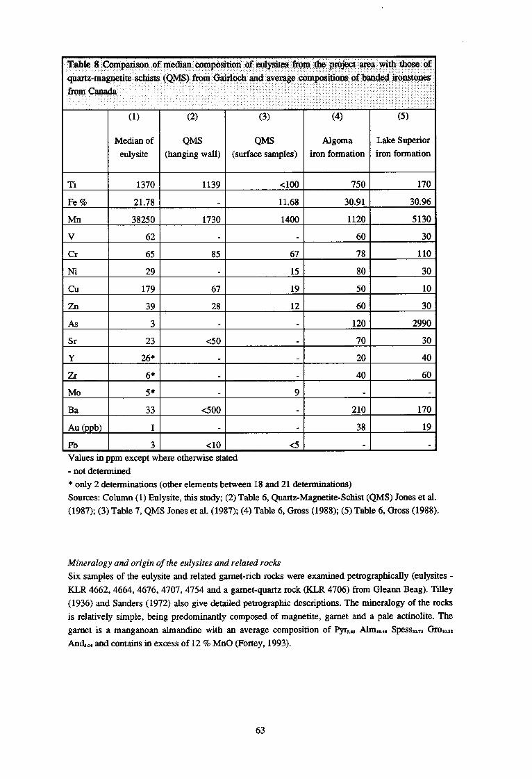
Table 8 Comparison of median composition of eulysites from the project area with th@e of
quartz-magnetite schists (QMS) from Gairloch and average composition of bauded ironston@ from Canada
(1) (2) (3) (4) (5)
Median of Qm QM Algoma Lake Superior
eulysite (hanging wall) (surface samples) iron formation iron formation
Ti 1370 1139 cl00 750 170
Fe % 21.78 11.68 30.91 30.96
38250 1730 1400 1120 5130
V 62 60 30
Cr 65 85 67 78 110
Ni 29 15 80 30
cu 179 67 19 50 10
Zn 39 28 12 60 30
As 3 120 2990
Sr 23 <50 70 30
Y 26* 20 40
Zr 6” 40 60
MO 5” 9
Ba 33 e500 210 170
Au (ppb) 1 38 19
Pb 3 <lO <5
Values in ppm except where otherwise stated
- not determined
* only 2 determinations (other elements between 18 and 21 determinations)
Sources: Column (1) Eulysite, this study; (2) Table 6, Quartz-Magnetite-Schist (QMS) Jones et al.
(1987); (3) Table 7, QMS Jones et al. (1987); (4) Table 6, Gross (1988); (5) Table 6, Gross (1988).
Mineralogy and origin of the eulysites and related rocks
Six samples of the eulysite and related garnet-rich rocks were examined petrographically (eulysites -
KLR 4662,4664,4676,4707,4754 and a garnet-quartz rock (KLR 4706) from Gleann Beag). Tilley
(1936) and Sanders (1972) also give detailed petrographic descriptions. The mineralogy of the rocks
is relatively simple, being predominantly composed of magnetite, garnet and a pale actinolite. The
garnet is a manganoan almandine with an average composition of Pyr,.,, Aim,,, Spess~ &oh332
Andso, and contains in excess of 12 % MnO (Fortey, 1993).
63

The eulysites are stratabound and were deposited within a mixed assemblage of volcanic rocks
(primitive MORB-type basalt@ and sedimentary rocks (limestones, calcareous pelites and pelites).
These iron-rich rocks have an unusual chemistry, and the protolith has been described as a
sedimentary ironstone by Tilley (1936) and a similar conclusion was reached by Sanders (1972).
However, the unusual chemistry of the eulysite, with very high levels of Mn and Cu and low levels of
elements such as Ti, Zr and Ba, indicates that a detrital origin is unlikely. Associated rock-types, such
as the spessartine-rich coticules (Kennan, 1986), also indicate an exhalative origin rather than a
detrital one. Comparison with modem analogues in the Pacific (Hekinian et al., 1993) indicates that it
could have been formed as a submarine exhalite from solutions formed by mixing between sea water
and hydrothermal fluids issuing from a submarine volcanic sequence. The discontinous nature of the
eulysite may be an original feature, as modem analogues are commonly found with dimensions of the
order of tens of metres across (Binns et al., 1993), distributed at intervals along a line of submarine
vents. In summary, therefore, the eulysite and associated garnet-rich rocks are believed to have been
formed as a submarine exhalative sediment within a mixed volcanic and sedimentary assemblage.
Pyrite-bearing Calc-silicate rocks
At several localities in the Carr Brae area pyrite-bearing talc-silicate gneisses occur adjacent to the
main marble units. These are typically green in colour with between 5 and 10% sulphides visible in
hand specimen. Three samples examined petrographically are composed of plagioclase, tremolite and
various accessory minerals, including sphene, clinozoisite, quartz and muscovite. The rocks were
sampled for their sulphide content, which is predominantly pyrite with accessory pyrrhotite,
chalcopyrite and molybdenite. Graphite is also present in two of the three samples examined
mineralogically. (Xc-silicate rocks or metamorphic skams are often described as being extremely
inhomogeneous, mineralogically variable, they are often monomineralic or bimineralic, with
compositions that reflect carbonate-silicate reactions, rather than original sediment composition
(Rock, 1987).
Thirty samples of the talc-silicate gneisses were collected, and the locations can be obtained from the
MRP Geochemistry Database. The chemical data is summarised in Table 9. The calcium content
ranges from 0.91% up to 13.65%, but there is a clear cluster with around 4.6 %Ca. This wide range is
a typical feature of talc-silicate rocks, as stated above, but the clustering around the median indicates
that there was a common parent composition. Iron behaves in a similar fashion and suggests that the
rocks were derived from the metamorphism of muddy, impure dolomitic rocks or marls.
Gold is significantly above detection limit (5 ppb) in only two samples (KLR 4270 with 46 ppb and
KLR 4271 with 25 ppb) both of which were collected in Leth Allt at [ 190980 8233401. These samples
have elevated copper values of 256 ppm and 410 ppm repectively, but other pathfinder elements, such
as As, Ag, Sb and Bi are low. The low content of gold (1 - 4 ppb) in the talc-silicate samples KLR
3847,4667 and 4668 collected from the vicinity of the old gold trial to the north west of Inverinate is
in contrast to the 1.8 ppm Au reported by Peach et al. (1910). One sample (KLR 4667) has the highest
arsenic content of any of the talc-silicate rocks but at 10 ppm As this cannot be regarded as a gold
pathfinder. Nickel, another element reported in the early account (0.8% Ni), is also low (56, 29, and
31 ppm Ni) in samples from the old trial.
Copper is enriched in the talc-silicate rocks, with a median content of 275 ppm. This contrasts with
the low levels in the marbles with medians of 2 ppm Cu (May et al. 1993) and 3 ppm Cu (this study).
Copper is positively correlated with nickel (Spearman 1=0.56) but not with iron (I=-O.ll), and seems
to be controlled by the sulphide content, rather than the clay silicate input from sedimentary sources.
64

The maximum content of 1049 ppm Cu is found in sample KLR 4697 from the southern part of the
Glenelg area at [181490 8139401.
Three samples of the talc-silicate gneiss were examined petrographically (KLR 4667, 4695 and
4697). The first sample was collected from the pyritic talc-silicate unit at the old gold trial at [ 189530
8243201 and in thin section is composed of granulitised bands of quartz, amphibole, muscovite and
feldspar. The amphibole has a relict core of silicic edenite (a sodic variety of hornblende) and
granulitised margins of tremolite. Sphene and clinozoisite are present as accessory minerals,
accompanied by about 2% pyrite and pyrrhotite. Graphite is also present as clusters of flaky grains,
typically 0.4 by 0.2 mm in size, forming about 4% of the rock by volume. KLR 4695 collected at
El82200 814030],800 m west of the outlet of Loch Bealach na h-Oidhche, has a similar mineralogy of
oligoclase, tremolite, sphene, pyrite and graphite but accessory molybdenite is also present. KLR 4697
from [ 182490 8 139401 300 m nearer the loch has a different mineralogy with andesine and augite
being the major phases accompanied by sphene, pyrite and accessory pyrrhotite and chalcopyrite. The
differences in mineralogy are probably the result of metamorphic retrogression from granulite facies
(May et al., 1993), but the original sediment must have been quite variable in composition with some
of the precursors being enriched in carbon and molybdenum.
Table 9 Summary statistics for the talc-silicate gneiss samples
N I I Median Minimum
Ca I 301 4610C
Ti I 301 2810 I 2218 4180 3449 2029
I 78 248 190 196
100 87301
I 21 10541
851 2061 150) 86 9 3841
Mn I 301 610 4351 8801 7031 403 220 2020
+ 90500 Fe I 301 42200 318501 5 1000~ 435231 17167 15100
391 1071 731 45 7 190
+ 1049 1491 3831 3701 307 5
81 461 361 32 2
21 3
+
3221 10341 6501 465 70
821 5391 3441 383 27
Au (ppb) 1 301 2.5 11 41 4181 8.9 1
Pb I ’ 301 4.5 0
(All values in ppm, except Au in ppb)
The elevated contents of copper and, to a lesser extent gold, are scientifically interesting but the
present sampling indicates that the talc-silicate rocks have little economic potential. The accuracy of
the analyses reported by Peach et al (1910) is questionable and may overstate the gold assays to
interest potential investors. Alternatively, a small sulphide-rich lens may have been present at this
trial and was subsequently mined away causing abandonment of the enterprise. The reported 55 % Fe
content of one sample (Peach et al. 1910) indicates either a massive sulphide body or extremely
selective sampling. The memoir describes “many strings and finely disseminated particles of pyrites”,
which is similar to the talc-silicate rocks exposed close to the trial today.
65

Graphite-bearing gneiss
Graphite-bearing rocks with a noticeable pyrite content are exposed at several locations in Glenelg
and can be traced across the project area from Loch Duich to Gleann Beag (Figure 34). These
occurrences were also noted by Peach et al., (1910) and two localities near Lochan na Beinne Faide
[1861 82361 were singled out as being particularly rich in graphite (op cit. ~174). In the present
survey graphite was recorded in twenty-four rock samples and fourteen of these were estimated to
contain more than 5% visible graphite and are compared as a group. The summary statistics of their
chemistry is given in Table 10 and when normalised to the average shale given by Taylor and
MacLennan (1985) can be compared (Figure 35) with average black shale (Vine and Tourtelot, 1970)
and to Keretti black schists of Proterozoic age in Finland (Loukola-Ruskeeniemi 1992). The Glenelg
graphitic gneiss is depleted in Ba, Pb and Zn but enriched in Ca, Cr, Cu and V, reflecting a basaltic
rather than crustal input to the black shale basin. The high level of copper (median 178 ppm Cu) is
noteworthy, nearly reaching the levels (230 ppm Cu) in the Keretti black schists, which are associated
with the well known Outokumpu ore deposits in Finland.
Table 10 Summary statistics for samples of graph& gneiss ,
C
S
N Median 25 th 75 th Mean Standard Maximum Minimum
percentile percentile Deviation
12 21000 8950 38000. 35383 44178 161600 2500
12 15850 8450 21250 17505 14317 43700 100
All values in ppm, except Au in ppb
The median content of carbon is not very high (2.1% C) compared with the average black shale (3.2%
C) but just above the cut-off level of 1% C used to distinguish black from normal marine shales.
Normal marine sediments deposited from oxygenated bottom waters show relatively constant C/S
ratios of about 2.8 (Lyons and Berner 1992), but the samples from Glenelg exhibit a wide scatter and
do not follow this trerxk Sediments depe&ed under euxinic conditions typically have higher su@hur
levels but still follow the same C/S trend. The wide scatter of carbon and sulphur values at’ Waelg
does not allow even this hypothesis to be accepted. The high metamorphic grade will have modified
66

Eastern
2 km
Moine
facies gneiss
dominantly hornblende and biotite gnelss
marble and talc-silicate
Western facies gneiss
I WL
Ratagain Complex
+ IYI + +
Quartz monzonite
eclogite and older basic rock
graphitic gnelss samples
I‘ Diorite
-’ I
_*-- Major Faults
Figure 34 Location of graphite gneiss samples in the Eastern Lewisian
67

the original carbon and sulphur distribution, but it seems more likely that the original occurrence of
pyrite and organic matter in the sediments was very variable. Further work involving stable isotopes
may be needed to elucidate the effect of metamorphism on the bulk composition of the rocks.
+ Glenelg + Keretti --br V&T
1
0.1 Ba Ca Cr Cu Fe Mn Ni Pb Sr Ti V Zn
Figure 35 Comparison of Glenelg graphitic gneiss, Keretti black schists (Loukola-Ruskeeniemi
1992), and average black shale (Vine and Tourtelot 1970), normalised to Taylor and MacLennan’s
average shale (1985).
Rocks with graphite are sufficiently unusual in the United Kingdom to warrent some further
investigation, particularly as the mineral is fairly coarsely crystalline. Twelve samples were selected
for the determination of their total carbon and sulphur contents using the Leco method by Acme
Laboratories. The results are shown in Table 11 and the presence of a high carbon content is
confirmed in most samples. The richest sample KLR 4370 was collected from a 0.5 m gneiss layer
interbanded with amphibolites at [ 184680 8229801 and this locality is probably one of those recorded
by Peach et al. (1910).
One sample, KLR 47 12, which occurs at [ 182105 8163051 as a 20 cm thick band between two marble
units, was selected for petrographic study (Fortey, 1993) as being fairly typical of the graphitic gneiss. The bulk of the rock is crudely banded, with a fine grained interlocking mosaic of oligoclase,
phlogopite and actinolite with accessory sphene, apatite and zircon. Beautifully formed crystals of
flake graphite are very common, forming about 5 % of the thin section by volume and varying in size
from 0.4 by 0.08 mm up to 2.0 by 0.6 mm. The graphite is accompanied by chalcopyrite, pyrite and
rare pyrrhotite. The occurrence of talc-silicate minerals in black schist from the Outukumpu
assemblage is recorded by Loukola-Ruskeeniemi (1992), who suggested a black, dolomitic mudrock
precursor.
68

Table 11 Total carbon and sulphur contents of graphitic gneisses
Sample number
KLR4370
C S
161600 100
IUR4388 1 60001 437001
KLR4404 36900 43000
KLR4406 39100 18700
KLR4411 29600 15700
IUR4462 1000 55300
KTR4467 2500 18400
IuFt4700 62600 100
KLR4712 47500 10500
IuR4730 6400 9600
KLR4731 10200 23800
KLR4733 12400 5000
KLR4738 9800 16000
All values in ppm
THE RATAGAIN IGNEOUS COMPLEX
A suite of Caledonian igneous rocks forming the Ratagain igneous complex is intruded into the
Lewisian and Moinian metamorphic rocks and this has been the subject of several recent studies (May
et al., 1993). Previous workers have recorded the presence of mineralisation in the complex (Peach et
al., 1910; Aucott and Collingbom 1971; and Alderton, 1986,1988) and a small sampling programme
of the observed veins and shear zones to investigate spatial distribution of the electrum mineralisation
was carried out.
Twenty-five samples of mineralised veins and brecciated crush rocks were collected from several host
rock types, mainly different units of the Ratagain igneous complex but also Moinian and Lewisian
rocks. Alderton (1988) sampled twelve localities in the Ratagain complex and found anomalous
values of gold, up to maximum of 5.46 ppm Au at his site 12. This site lies near the eastern margin of
the intrusion and within the Strathconon fault zone. Another four samples of vein material were
collected in 1989 by A G GUM of the Minerals Group during the course of exploration for platinum
group elements. One of these samples, PGR 8079, resampled the Alderton site 12 anomaly at [193950
8198501 and the results are given in the following description. Because of the host rock variation,
summary statistics for the veins were only calculated for a few of the chalcophile elements (Table 12)
but full details of the analyses are available from the MRP database on request.
69

Tabie 12 Comparison of gold and base metal contents of veins in the Ratagain complex and the
Moine and Lewisian country rocks
N Median 25 th
percentile
75 th
percentile
i Minimum Maximum
Ratagain Complex
Lewisian and Maine country rocks
Au 6 1 1 2 1 4
Ag 5 1 0 1 0 2
cu 6 24 12 37 7 65
zn 6 48 42 51 25 72
As 6 2.5 0.5 9.75 0 18
pb 6 9 6 13 1 14
Bi I 5, 1, 01 2, 0, 2
All values in ppm, except Au in ppb
Gold levels in the veins are not very anomalous. Sample PGR 8079 contains 0.975 ppm Au, which is
probably more representative of the vein because of the larger sampling mass of the fire assay method
used by BGS compared to the 1.5 gm used in the neutron activation method employed by Alderton.
Further sampling (KLR 4262) of the vein in the course of this study produced only 37 ppb Au.
Mineralised veins in the Ratagain complex are concentrated within the quartz monzonite and have a
higher and more variable gold content (range 1 - 100 ppb and median 6 ppb Au) than veins and
breccia zones in the Moinian and Lewisian country rocks which have low concentrations of gold
(range 1-4 ppb Au in six samples). One unusual feature of the chemistry is that the veins in the
Ratagain complex have lower levels of arsenic, even though Alderton (1988) recorded two arsenic
minerals, tennantite and gersdorffite.
The exceptions to this are the Srath a’ Chomair veins, which are thin, 10 - 100 mm quartz-carbonate
veins cutting micaceous gneiss of the Eastern Lewisian and exposed in the upper reaches of the
Abhainn a’ Ghlinne Bhig at [187100 8158701. Two samples of these veins, IUR 4428 and 4430,
contain 400 and 110 ppb Au respectively and high levels of Cu (1.2 and 0.2 %), Pb (both >l %) and
Zn (both >0.5 %). Arsenic is also enriched to a lesser extent (95 and 23 ppm) along with nickel (74
and 70 ppm).
Zones of fenite-type, soda-metasomatism occur within the Ratagain igneous complex, most notably in
a roadside cutting at [189215 8198551. Blue Na-amphibole, shown by mineralogical work to be Mg-
riebeckite (Mitchell, 1994), and possible aegirine (not confirmed by XRD) are found on joint coatings
and in marginal alteration selvages. This metasomatism is closely similar to that described by Garson
70

et al. (1984) in the Great Glen and, also, to alteration in the Loch Ailsh (Coats, unpublished work)
and Loch Borralan intrusions (Rock, 1977). One sample of the metasomatised quartz monzonite
contains 17 ppb Au but low values of base metals. The metasomatism is another feature showing the
geological similarities between the Ratagain complex and the alkaline syenites of similar age in the
north west Highlands, which are intruded into the Lewisian foreland close to the Caledonian Moine
Thrust rather than within the thrust zone as is Ratagain.
The mineralisation in the Ratagain complex is concentrated within the quartz monzonite and, whilst
widespread and sporadic in extent, is never very localised or intense and gold grades are low. Late-
stage magmatic fluids are suggested by Alderton (1988) on the basis of fluid inclusion studies to have
caused the mineralisation and they seem to have caused extensive, low-grade mineralisation rather
than being focussed by a small late-stage intrusion or an active fault zone. The relationship between
these late-magmatic hydrothermal fluids and that responsible for the soda metasomatism is unknown.
The Srath a’ Chomair veins are a more interesting target since, like the one auriferous vein (site 12)
described by Alderton (1988), they occur within the Strathconon fault zone. This fault extends for
about 100 km and has been shown to have drainage anomalies for gold in the Scardroy area (Coats et
al., 1993). The fault is normally poorly exposed, and detailed drainage sampling and prospecting
along its length is justified.
CONCLUSIONS ’
The project area contains several promising indications for the occurrence of economic
mineralisation. The rocks of the Eastern Lewisian can be classified into three main groups:
metasediments, basic and and ultrabasic rocks, and hornblende and biotite gneisses. The hornblende
and biotite gneisses may form part of an earlier migmatite complex into which the igneous rocks were
subsequently emplaced and the sediments were deposited in a basement - cover relationship (May et
al., 1993). The metasediments are pelite, marble and talc-silicate, and quartzo-feldspathic gneiss, and
closely interbanded with these metasediments are basic and ultrabasic rocks, which have all been
subsequently metamorphosed to at least granulite facies. The most likely depositional environment
seems to be a rift setting, with primitive basaltic material being intruded into high levels in the crust
and on to the sea floor. Exhalative activity on the sea floor, with the mixing of seawater with
hydrothermal fluids emanating from the volcanic pile, could allow the production of highly iron-and
manganese-rich exhalative sediments, now represented by the eulysites and garnet-rich rocks. In such
highly deformed rocks it is difficult to prove a stratigraphic succession, but the eulysite seems to be
associated with the top of the igneous rocks and within the mixed sedimentary and, possibly,
tuffaceous sequence (Tables 6 and 7). At modem sea-floor vents intense bacterial activity takes place
and this could produce the highly carbonaceous and pyritic rocks seen in this area. Deposition of
limestone, dolomitic sediments and black shales (now represented by the marble, talc-silicate rock
and graphitic gneiss) took place with some input of igneous material during the waning part of the
volcanic activity.
The Eastern Lewisian in the Glenelg area has affinities with Lewisian rocks in South Harris in terms
of the rock types present, the chemistry of marbles (Rock 1983) but the occurrence of iron or
manganese rocks has not been recorded in the Outer Hebrides. There are more similarities with the
Tiree and Gairloch areas, where BlFs have been recorded and these will be the subject of a later
report. The occurrence of BIFs at Glenelg and Tiree is indicative of exhalative activity in the
Lewisian, and may be related to similar gold and base metal mineralisation to that recorded at
Gairloch (Jones et al., 1987).
71

If the eulysite is an exhalative deposit, as is suggested, it could provide a stratigraphic marker to
Be&i-style or volcanic massive sulphide deposits. However, despite tracing the outcrops of the
eulysite for 13 km very little evidence for base-metal mineralisation could be found except for some
marginally high copper values. Some of the rock types associated with the eulysite show slightly better
potential, and the talc-silicate rocks do contain relatively high (though subeconomic) levels of copper
and some gold.
In the metasedimentary sequence the graphite-bearing lithologies have the highest economic potential
and it is recommended that further work is undertaken to investigate the occurrence of coarsely
crystalline graphite. Graphite is a valuable industrial mineral, ranging in price from $250 to $500 per
metric tonne. The variation in price is dependant on the grain size of the graphite, coarse, highly
crystalline graphite attracting the highest prices. A full economic evaluation of the graphite has not
been attempted in this study but there is clearly some potential. Laboratory testing is required to
ascertain that the graphite can be easily liberated from the host rock. and the resultant grain size.
Further field sampling to assess the representivity of the samples will also be necessary.
The project area has some potential for further discoveries of gold-bearing sulphide veins. It is not
considered that there are any to be found within the Ratagain complex, which is relatively well
exposed and has been extensively mapped and explored. However, the indications of vein-style
mineralisation, which have been found by drainage sampling, on the north side of Loch Alsh and,
perhaps, on the southern side of Loch Carron are promising, and may repay limited exploration. The
Strathconon fault zone is also considered to be propspective for gold mineralisation.
REFERENCES
ALDERMAN, A R. 1936. Eclogites in the neighbourhood of Glenelg, Inverness-shire. Quarterly
Journal of the Geological Society of London, 92,488-528.
ALDERTON, D H M. 1986. Hessite and electrum from the Ratagain intrusion, north-west Scotland.
Mineralogical Magazine, 50, 179.
ALDERTON, D H M. 1988. Ag-Au-Te mineralization in the Ratagain complex, northwest Scotland
Transactions of the Institution of Mining and Metallurgy (Section B: Applied Earth Science), 97,
B171-B180.
AUCO’IT, J W. 1970. Applied geochemical survey of the Ratagan area of Wester Ross and Invemess-
shire. Institute of Geological Sciences, Radiogeology and Rare Minerals Unit, RMMU Report 301.
AUCOTT, J W and COLLINBORN, C E M. 1971. Applied geochemical follow-up survey of the Ratagan
area - Wester Ross and Inverness-shire. Institute of Geological Sciences, Radiogeology and Rare
Minerals Unit, RMMU Report 312.
BARBER, A J. 1968. The geology of the country around Domie, Wester Ross. Unpublished PhD thesis,
University of London.
BARBER, A J andmy, F. 1975. The history of the Western Lewisian in the Glenelg inlier, Lochalsh,
Northern Highlands. Scottish Journal of Geology, 12,35-50.
BEACH, A and TARNEY, J. 1978. Major and trace element patterns established during retrogressive
metamorphism of granulite-facies gneisses, N. W. Scotland. Precambrian Research, 7,325-348.
72

BERRIDGE, N.G. 1969. A summary of the mineral resources of the ‘Crofter Counties’ of Scotland,
comprising Argyllshire, Caithness, Inverness-shire, Orkney and Shetland, Ross and Cromarty, and
Sutherland. (London, HMSO), Report of the Institute of Geological Sciences, 69/5.
BINNS, R A, SCOTT, S D, BOGDANOV, Y A, LISITZIN, A P, GORDEEV, V V, GIJRVICH, E G,
FINLAYsoN, E J, BOYD, T, DOTTER, L E, WHELLEIR, G E and MURAVYEV K G. 1993. Hydrothermal
oxide and gold-rich sulphate deposits of Franklin Seamount, Western Woodlark Basin, Papua New
Guinea. Economic Geology, 88,2122-2153.
BRITISH GEOLOGICAL SURVEY. 1987. Regional geochemical atlas: Great Glen. (Keyworth,
Nottinghamshire: British Geological Survey.)
CLIFFORD, T N. 1959. A preliminary note on chromium mica in an ankerite-quartz-pyrite rock from
southern Ross-shire, Scotland. Mineralogical Magazine, 32,178-180.
COATS, J S, SHAW, M H and SMITH, R T. 1993. Mineral investigations in the Scardroy area, Highland
Region, Scotland. British Geological Survey, Mineral Reconnaissance Programme, Open File Report
No. 12.
FORTEY, N J. 1993. Petrography and mineralogy of Lewisian rocks. British Geological Survey
Technical Report WGl93114C.
GALLAGHER, M J, SMITH, R T, PEACOCK, J D, and HAYNIZS, L. 1974. Molybdenite mineralization in
Precambrian rocks near Lairg, Scotland. Transactions of the Institution of Mining and Metallurgy
(Section B: Applied Earth Science), 83, B81-B87.
GROSS, G A. 1988. Gold content and geochemistry of iron-formation in Canada. Geological Survey of
Canada Paper 86-19.
GUNN, A G. 1989. Drainage and overburden geochemistry in exploration for platinum-group element
mineralisation in the Unst ophiolite, Shetland, U.K. Journal of Geochemical Exploration, 31, 20%
236.
HEKINIAN, R, HOFFERT, M, LARQUE, P, CHEMINEE, J L, STOFFERS, P and BIDEAU, D. 1993.
Hydrothermal Fe and Si oxyhydroxide deposits from South Pacific intraplate volcanoes and East
Pacific Rise axial and off-axial regions. Economic Geology, 88,2099-2121.
JONES, E M, RICE, C M, and T~EEDIE, J R. 1987. Lower Proterozoic stratiform sulphide deposits in
Loch Maree Group, Gairloch, northwest Scotland. Transactions of the Institution of Mining and
Metallurgy (Section B: Applied Earth Science), 96, B128-B140.
KENNAN, P S. 1986. The coticule package: a common association of some very distinctive lithologies.
Aardkundige Mededelingen, 3, 139- 148.
LOUCOLA-RUSKEENIEMI, K. 1992. Geochemistry of Proterozoic metamorphosed black shales in eastern
Finland, with implications for exploration and environmental studies. Academic dissertation,
University of Helsinki, Finland, 36pp.
LYONS, T W and BERNER, R A. 1992. Carbon-sulfur-iron
sediments of the Black Sea. Chemical Geology, 99, l-27.
73
systematics of the uppermost deep-water

MAY, F, PEA=, J D, SMITH, D I, and BARBER, A J, 1993. Geology of the Kintail district. Memoir
of the British Geological Survey, Sheet 72W and part of 71E (Scotland).
IV&RCY, E L P and O’HARA, M J, 1968. Nepheline normative eclogite from Loch Duich, Ross-shire.
Scottish Journal of Geology, 4, l-9.
NICHOLLS, G D. 195 1. The Glenelg-Ratagain igneous complex. Quarterly Journal of the Geological
Society of London, 106,309-344.
PEACH, B N, HORNE, J, GUNN, W, CLOUGH, C T, HINXMAN, L and TEALL, J J H. 1907. The geological
structure of the North West Highlands. Memoir of the Geological Survey of Scotland.
PEACH, B N, HORNE, J, WOODWARD, H B, CLOUGH, C T, HARK& A and WEDD, C B. 1910. The
geology of Glenelg, LochaIsh and south-east part of Skye. Memoir of the Geological Survey of
Scotland.
PLANT, J A. 1971. Orientation studies on stream sediment sampling for a regional geochemical survey
in northern Scotland. Transactions of the Institution of Mining and Metallurgy (Section B: Applied
Earth Science), 80, B234-B245.
RAMSAY, J G. 1957. Moine - Lewisian relations at Glenelg, Inverness-shire. Quarterly Journal of the
Geological Society of London, 113,487-523.
ROCK, N M S. 1983. The Permo-Carboniferous camptonite-monchiquite dyke suite of the Scottish
Highlands and Islands: distribution, field and petrological aspects. (London, HMSO) Report of the
Institute of Geological Sciences, 82/14.
ROCK, N M S. 1987. The geochemistry of Lewisian marbles. From: PARK, R G and TARNEY, J. (eds),
Evolution of the Lewisian and comparable Precambrian high grade terrains. Geological Society
Special Publication No. 27,109-126.
ROCK, N M S, DULLAR, P, HAZLEDINE, R S and GROVES, D I. 1987. Lamprophyres as potential gold
exploration targets: some preliminary observations and speculations. From: GROVES, D I and HO, S E.
(eds). University of Western Australia Extension Publication, No 11, l-16.
ROLLINSON, H R. 1993. Using geochemical data: evaluation, presentation, interpretation. (Harlow,
Essex, Longman Scientific and Technical).
SANDERS, I S. 1972. The petrology of eclogites and related rocks at Glenelg, Inverness-shire.
Unpblished PhD thesis, University of Cambridge.
STANTON, R L, 1976. Petrochemical studies of ore environment, Broken Hill, New South Wales,
Australia: 1 - constitution of ‘banded iron formations’. Transactions of the Institution of Mining and
Metallurgy (Section B: Applied Earth Science), 85, B33-B46.
SUTI’ON, J and WATSON, J. 1958. Structures in the Caledonides between Loch Duich and Glenelg,
north-west Highlands. Quarterly Journal of the Geological Society of London, 114,231-257.
TAKOR, S R and MCLENNAN, S H. 1985. The continental crust: its composition and evolution.
(Oxford. Blackwells).
74

TILLEY, C E. 1936. Eulysites and related rock types from Loch Duich, Ross-shire. Mineralogical
Magazine, 24,331-342.
TILLEY, C E. 1937. Pyroxmangite from Inverness-shire, Scotland. American Mineralogist, 22, 720-
727.
VINE, J D and TOURTELOT, E B. 1970. Geochemistry of black shale deposits - a summary report.
Economic Geology, 65,253-272.
WEAVER, B L and TARNEY, J. 1981. The Scourie dyke suite: petrogenesis and geochemical nature of
the Proterozoic sub-continental mantle. Contributions to Mineralogy and Petrology, 78,175-188.
WILLIAMS, P J. 1986. Petrology and origin of iron-rich silicate-magnetite-quartz rocks from
Flowerdale near Gairloch, Wester Ross. Scottish Jounal of Geology, 22, 1-12.
WILLIAMS, P J, TOMKINSON, M J and CATIELL, A C. 1985. Petrology and deformation of
metamorphosed volcanic-exhalative sediments in the Gairloch Schist Belt, N. W. Scotland.
Mineralium Deposita, 20, 302-308.
75
