military terrain style contents -...
TRANSCRIPT

Military Terrain Style - ColorsBlack
Grid Black
Fore Black
Built Black
Blue
Grid Blue
Red Brown
Grid Brown
Aero Blue
Green
Yellow
Purple
Grid Purple
Brown
Black 7-45
Black 12-15
Black 12-45
Black 21-45
Black 31-45
Black 42-45
Black 54-30/60
Black 54-45
Black 67-30/60
Blue 4-45
Blue 12-45
Blue 21-45
Blue 31-45
Blue 31-75
Green 12-15
Green 12-45
Green 21-45
Green 31-75
AeroBlue 4-45
AeroBlue 12-15
AeroBlue 21-45
AeroBlue 31-45
AeroBlue 31-75
Red Brown 7-45
Red Brown 21-75
Red Brown 42-60
Red Brown 54-60
Red Brown 67-30/60
Yellow 79-30
Yellow 42-15
Yellow 42-75
HAC Black
HAC Nav Aids
HAC Water 5
HAC Water 10
HAC Land
HAC Bua
HAC Utm
Purple 2
White
Red
Copyright © 1999 - 2004 ESRI.All Rights Reserved.
Located in: ArcGIS\Bin\Styles\Military Terrain.styleVersion: ArcGIS 8.3 1

Military Terrain Style - Fill SymbolsTerrain 01
Terrain 02
Terrain 03
Terrain 04
Terrain 05
Terrain 06
Terrain 07
Terrain 08
Terrain 09
Terrain 10
Terrain 11
Terrain 12
Terrain 13
Terrain 14
Terrain 15
Terrain 16
Terrain 17
Terrain 18
Terrain 20
Terrain 22
Terrain 24
Terrain 26
Terrain 28
Terrain 30
Terrain 32
Terrain 34
Terrain 36
Terrain 38
Terrain 40
Terrain 42
Terrain 44
Terrain 46
Terrain 48
Terrain 50
Terrain 52
Terrain 54
Terrain 56
Terrain 58
Terrain 60
Terrain 62
Terrain 64
Terrain 66
Terrain 68
Terrain 70
Terrain 72
Terrain 74
Terrain 76
Terrain 78
Terrain 80
Terrain 82
Terrain 83
Terrain 84
Terrain 87
Terrain 89
Copyright © 1999 - 2004 ESRI.All Rights Reserved.
Located in: ArcGIS\Bin\Styles\Military Terrain.styleVersion: ArcGIS 8.3 2

Military Terrain Style - Fill SymbolsTerrain 91
Terrain 93
Terrain 95
Terrain 97
Terrain 99
Terrain 101
Terrain 103
Terrain 105
Terrain 107
Terrain 109
Terrain 111
Terrain 113
Terrain 115
Terrain 117
Terrain 119
Terrain 121
Terrain 123
Terrain 125
Terrain 127
Terrain 129
Terrain 131
Terrain 133
Terrain 135
Terrain 137
Terrain 139
Terrain 141
Terrain 143
Terrain 145
Terrain 147
Terrain 149
Terrain 151
Terrain 153
Terrain 155
Terrain 157
Terrain 159
Terrain 161
Terrain 163
Terrain 165
Terrain 167
Terrain 169
Copyright © 1999 - 2004 ESRI.All Rights Reserved.
Located in: ArcGIS\Bin\Styles\Military Terrain.styleVersion: ArcGIS 8.3 3

Military Terrain Style - Marker Symbols( Empty 1
( Control point, Light
) Chimney, Water tower, Monument
( Tank, Control point, (vertical)
( Well (perennial)
$ Miscellaneous cultural feature 1
$ Cistern
} Storage bunker/storage mound
, Building (School)
¥ Building (Church) 1
( Empty 2
- Building (Marabout)
¤ Building (Synagogue), Cemetery (Jewish)
« Cemetery (Buddhist)
$ Building (Single family dwelling, House)
Copyright © 1999 - 2004 ESRI.All Rights Reserved.
Located in: ArcGIS\Bin\Styles\Military Terrain.styleVersion: ArcGIS 8.3 4

Military Terrain Style - Marker SymbolsE Tent dwelling
% Vertical Obstruction 1
¬ Cave dwelling
- Power line tower
% Vertical Obstruction 2
z Rock/Coral (awash)
{ Rock/Coral (covers & uncovers)
{ Rock formation (Pinnacle)
j Ice peak/Nunatak (rock)
j Ice peak/Nunatak (snow/ice)
ª Mountain pass
· Tunnel (road)
· Tunnel (aqueduct)
Ú Culvert
5 Building (School)
Copyright © 1999 - 2004 ESRI.All Rights Reserved.
Located in: ArcGIS\Bin\Styles\Military Terrain.styleVersion: ArcGIS 8.3 5

Military Terrain Style - Marker Symbols: Building (Church) 2
9 Building (Mosque)
0 Building (Synagogue)
£ Cemetery (Islamic)
&' Well (non-perennial)
d Flow arrow
r Geothermal feature
r Spring (perennial)
xy Wreck
¸ Rapids, Waterfall
¹ Dam
' Railroad tick (Narrow gauge, Double track) 1
& Railroad tick (Normal gauge, Double track)
) Railroad tick (Narrow gauge, Single track, Electric)
, Railroad tick (Normal gauge, Single track, Electric)
Copyright © 1999 - 2004 ESRI.All Rights Reserved.
Located in: ArcGIS\Bin\Styles\Military Terrain.styleVersion: ArcGIS 8.3 6
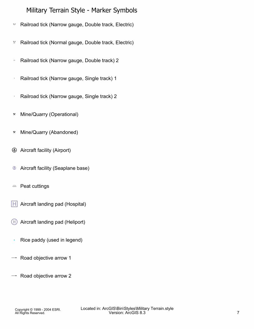
Military Terrain Style - Marker Symbols* Railroad tick (Narrow gauge, Double track, Electric)
( Railroad tick (Normal gauge, Double track, Electric)
' Railroad tick (Narrow gauge, Double track) 2
+ Railroad tick (Narrow gauge, Single track) 1
+ Railroad tick (Narrow gauge, Single track) 2
! Mine/Quarry (Operational)
! Mine/Quarry (Abandoned)
¼ Aircraft facility (Airport)
¿ Aircraft facility (Seaplane base)
"# Peat cuttings
h Aircraft landing pad (Hospital)
Ü Aircraft landing pad (Heliport)
ß Rice paddy (used in legend)
æ Road objective arrow 1
æ Road objective arrow 2
Copyright © 1999 - 2004 ESRI.All Rights Reserved.
Located in: ArcGIS\Bin\Styles\Military Terrain.styleVersion: ArcGIS 8.3 7

Military Terrain Style - Marker SymbolsÐ Road objective arrow (arrow head only)
Ô River/stream vanishing point (dissipating)
Ð Arrowhead 2
¼ Aircraft facility
( Spot Elevation
à Control point (Horizontal)
Æ Boundary marker
¸ Point of change identifier (Transportation)
¸ Point of change identifier (Hydrography)
¸ Railroad tick 1
% Railroad tick 2
( Misc nautical 1
R Bridge 1
Q Bridge 2
å Vertical Obstruction (separated symbol) 2
Copyright © 1999 - 2004 ESRI.All Rights Reserved.
Located in: ArcGIS\Bin\Styles\Military Terrain.styleVersion: ArcGIS 8.3 8

Military Terrain Style - Marker Symbols- Powerline pylon
k Multiple Obstructions
( Light
é Multiple Vertical obstructions (symbol separated)
Ó Stadium
Y Navaid (Vortac omnirange)
_ Navaid (VOR/DME)
S Navaid (Radio facilities)
V Navaid (VOR omnirange) 1
e Navaid (VOR omnirange) 2
& Airport
dTunnel, Navaid (visual)
× True North Star 1
Ø Magnetic North arrow head (left) 1
Ù Magnetic North arrow head (right) 1
Copyright © 1999 - 2004 ESRI.All Rights Reserved.
Located in: ArcGIS\Bin\Styles\Military Terrain.styleVersion: ArcGIS 8.3 9

Military Terrain Style - Marker Symbols× True North Star 2
Ø Magnetic North arrow head (left) 2
Ù Magnetic North arrow head (right) 2
× True North Star 3
Ø Magnetic North arrow head (left) 3
Ù Magnetic North arrow head (right) 3
× True North Star 4
Ø Magnetic North arrow head (left) 4
Ù Magnetic North arrow head (right) 4
× True North Star 5
Ø Magnetic North arrow head (left) 5
Ù Magnetic North arrow head (right) 5
× True North Star 6
Ø Magnetic North arrow head (left) 6
Ù Magnetic North arrow head (right) 6
Copyright © 1999 - 2004 ESRI.All Rights Reserved.
Located in: ArcGIS\Bin\Styles\Military Terrain.styleVersion: ArcGIS 8.3 10

Military Terrain Style - Marker Symbols× True North Star 7
Ø Magnetic North arrow head (left) 7
Ù Magnetic North arrow head (right) 7
× True North Star 8
Ø Magnetic North arrow head (left) 8
Ù Magnetic North arrow head (right) 8
à Vegetation symbols used for the legend 1
á Vegetation symbols used for the legend 2
ã Vegetation symbols used for the legend 3
â Vegetation symbols used for the legend 4
# Chimney/smokestack (conspicuous), Foreshore
$ Tower (non-communication-conspicuous)
% Container crane
& Flare pipe (on ground-conspicuous)
( Windmill/windmotor (other-conspicuous)
Copyright © 1999 - 2004 ESRI.All Rights Reserved.
Located in: ArcGIS\Bin\Styles\Military Terrain.styleVersion: ArcGIS 8.3 11

Military Terrain Style - Marker Symbols) Miscellaneous cultural feature 2
* Building (cathedral/church), Building
+ Building (pagoda/shrine/temple-conspicuous)
. Rescue station
2 Display sign (marine)
3 Flagstaff/flagpole (conspicuous)
4 Monument 1
5 Ferry (used on line symbol) 1
7 Water tower (conspicuous)
9 Mooring mast (conspicuous)
@ Built-up area
A Communication tower (conspicuous) 1
C Anchorage (General, Tanker, or Time limited)
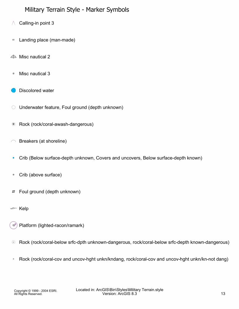
F Calling-in point 1
G Calling-in point 2
Copyright © 1999 - 2004 ESRI.All Rights Reserved.
Located in: ArcGIS\Bin\Styles\Military Terrain.styleVersion: ArcGIS 8.3 12
Military Terrain Style - Marker Symbols
H Calling-in point 3
J Landing place (man-made)
K Misc nautical 2
L Misc nautical 3
QN Discolored water
O Underwater feature, Foul ground (depth unknown)
P Rock (rock/coral-awash-dangerous)
R Breakers (at shoreline)
"S Crib (Below surface-depth unknown, Covers and uncovers, Below surface-depth known)
T Crib (above surface)
U Foul ground (depth unknown)
V Kelp
WÂe Platform (lighted-racon/ramark)
X Rock (rock/coral-below srfc-dpth unknown-dangerous, rock/coral-below srfc-depth known-dangerous)
Y Rock (rock/coral-cov and uncov-hght unkn/kndang, rock/coral-cov and uncov-hght unkn/kn-not dang)
Copyright © 1999 - 2004 ESRI.All Rights Reserved.
Located in: ArcGIS\Bin\Styles\Military Terrain.styleVersion: ArcGIS 8.3 13
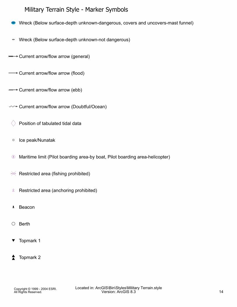
Military Terrain Style - Marker Symbols][ Wreck (Below surface-depth unknown-dangerous, covers and uncovers-mast funnel)
\ Wreck (Below surface-depth unknown-not dangerous)
^Current arrow/flow arrow (general)
_Current arrow/flow arrow (flood)
`Current arrow/flow arrow (ebb)
a Current arrow/flow arrow (Doubtful/Ocean)
b Position of tabulated tidal data
j Ice peak/Nunatak
f Maritime limit (Pilot boarding area-by boat, Pilot boarding area-helicopter)
# Restricted area (fishing prohibited)
l Restricted area (anchoring prohibited)
q Beacon
s Berth
t Topmark 1
u Topmark 2
Copyright © 1999 - 2004 ESRI.All Rights Reserved.
Located in: ArcGIS\Bin\Styles\Military Terrain.styleVersion: ArcGIS 8.3 14

Military Terrain Style - Marker Symbolsv Wreck (below surface-depth unknown but safe) 1
w Topmark 3
x Topmark 4
y Topmark 5
z Topmark 6
{ Buoy 1
Qv Wreck (below surface-depth unknown but safe) 2
§ Roundabout (separation zone point)
© Buoy 2
ª Buoy 3
« Buoy 4
¨ Misc nautical 4
Topmark 7
® Topmark 8
¯ Topmark 9
Copyright © 1999 - 2004 ESRI.All Rights Reserved.
Located in: ArcGIS\Bin\Styles\Military Terrain.styleVersion: ArcGIS 8.3 15

Military Terrain Style - Marker Symbols° Topmark 10
± Topmark 11
² Buoy 5
³ Buoy 6
´ Buoy 7
µ Buoy 8
¶ Buoy 9
· Buoy 10
¸ Buoy 11
¹ Buoy 12
º Buoy 13
» Buoy 14
¼ Buoy 15
½ Buoy 16
¾ Buoy 17
Copyright © 1999 - 2004 ESRI.All Rights Reserved.
Located in: ArcGIS\Bin\Styles\Military Terrain.styleVersion: ArcGIS 8.3 16

Military Terrain Style - Marker Symbols¿ Signal 1
À Signal 2
Á Signal 3
 Navigation system type 2
à Buoy 18
Ä No bottom found at depth shown
Å Eddies
Æ Overfalls/tid rips
Ç Trees (casuarina)
È Trees (coniferous)
É Trees (nipa palm)
Ë Trees (filao)
Ì Trees (evergreen)
Í Trees (deciduous)
Î Trees (eucalyptus)
Copyright © 1999 - 2004 ESRI.All Rights Reserved.
Located in: ArcGIS\Bin\Styles\Military Terrain.styleVersion: ArcGIS 8.3 17

Military Terrain Style - Marker SymbolsÏ Bottom characteristics (springs in seabeds)
Ð Bottom characteristics (Mobile bottom/sandwaves)
Ñ Crane
Ò Flare
Ó Battery
Ô Fort, Building (castle)
Õ Windmill/windmotor (electric)
Ö Building (post office)
× Building (Health office, Hospital
Ø Building (custom house)
Ù Building (harbor master's office)
Ú Building (stupa-conspicuous)
Û Communication tower (conspicuous) 2
Ü Heliport
Þ Anchorage (berths)
Copyright © 1999 - 2004 ESRI.All Rights Reserved.
Located in: ArcGIS\Bin\Styles\Military Terrain.styleVersion: ArcGIS 8.3 18

Military Terrain Style - Marker Symbolsß Anchorage (quarantined)
à Anchorage (deep water/deep draft)
á Misc nautical 5
â Perch/stake
ã Perch/stake (arrow-starboard)
ä Perch/stake (y-port)
å Piling (below surface-not accurate)
ç Rock (rock/coral-below srfc-depth unkn-not dang, rock/coral-below srfc-depth known-not dang)
éDirection of flow
ê Mine danger area (maintained), Prohibited area, Restricted area, Restricted area (area to avoid)
ë Topmark 12
ì Topmark 13
í Topmark 14
î Topmark 15
ï Topmark 16
Copyright © 1999 - 2004 ESRI.All Rights Reserved.
Located in: ArcGIS\Bin\Styles\Military Terrain.styleVersion: ArcGIS 8.3 19

Military Terrain Style - Marker Symbolsð Topmark 17
ñ Topmark 18
ò Topmark 19
ó Topmark 20
ô Topmark 21
õ Topmark 22
ö Topmark 23
÷ Topmark 24
ø Topmark 25
ù Topmark 26
ú Topmark 27
û Topmark 28
ý Topmark 29
þ Misc nautical 6
ÿ Topmark 30
Copyright © 1999 - 2004 ESRI.All Rights Reserved.
Located in: ArcGIS\Bin\Styles\Military Terrain.styleVersion: ArcGIS 8.3 20
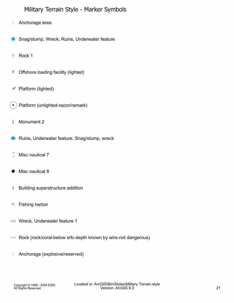
Military Terrain Style - Marker SymbolsC Anchorage area
QO Snag/stump, Wreck, Ruins, Underwater feature
OY Rock 1
Ld Offshore loading facility (lighted)
We Platform (lighted)
"Â Platform (unlighted-racon/ramark)
: Monument 2
QO? Ruins, Underwater feature, Snag/stump, wreck
> Misc nautical 7
6 Misc nautical 8
- Building superstructure addition
I Fishing harbor
?O Wreck, Underwater feature 1
? Rock (rock/coral-below srfc-depth known by wire-not dangerous)
C Anchorage (explosive/reserved)
Copyright © 1999 - 2004 ESRI.All Rights Reserved.
Located in: ArcGIS\Bin\Styles\Military Terrain.styleVersion: ArcGIS 8.3 21

Military Terrain Style - Marker Symbols°̄ Trees (palm)
" Platform (unlighted)
5 Ferry (used on line symbol) 2
Ø Customs boundary (for line symbol)
( Island 1
b Tidal stream data point
n Misc nautical 9
QQO Ruins (above surface)
è Route (line symbol decorations) 1
| Route (line symbol decorations) 2
è Route (line symbol decorations) 3
)*+Ò Flare pipe (off shore)
n Navaids (aeronautical)
³́å Piling (below surface-accurate), Snag/stump (below surface-depth unknown-accurate
} Calling-in point 4
Copyright © 1999 - 2004 ESRI.All Rights Reserved.
Located in: ArcGIS\Bin\Styles\Military Terrain.styleVersion: ArcGIS 8.3 22

Military Terrain Style - Marker Symbolsá Marker
¡ Raoundabout (narrow)
¢ Current diagram
Ð Arrowhead 1£ Traffic Separation scheme (arrow)¤ Route
Á Radar reflector
¥ Buoy 19
ü Cemetery (Christian)
r Cemetery (Jewish)
; Buoy 20
j Line decoration
¦ Navigation system type 1
Þ Anchorage 1
ß Anchorage 2
Copyright © 1999 - 2004 ESRI.All Rights Reserved.
Located in: ArcGIS\Bin\Styles\Military Terrain.styleVersion: ArcGIS 8.3 23

Military Terrain Style - Marker Symbolsà Anchorage 3
ê Mine danger area
l Restricted area
× Anchorage 4
× Anchorage 5
Ý Misc nautical 10
çè Wreck, Underwater feature 2
æ Rock 2
EEEE Island 2
QO miscellaneous underwater feature 1
QO miscellaneous underwater feature 2
QO miscellaneous underwater feature 3
$ Building (Single family dwelling, House)
{ Point symbol ERROR
Copyright © 1999 - 2004 ESRI.All Rights Reserved.
Located in: ArcGIS\Bin\Styles\Military Terrain.styleVersion: ArcGIS 8.3 24
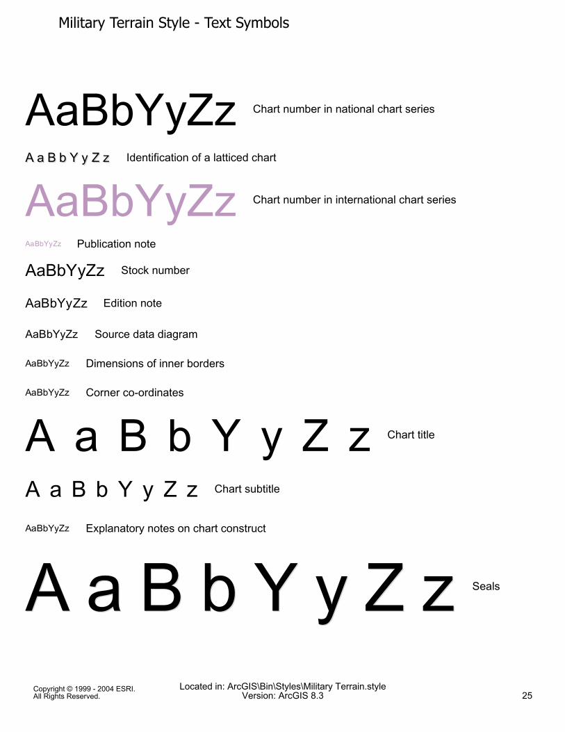
Military Terrain Style - Text Symbols
AaBbYyZz Chart number in national chart series
A a B b Y y Z zA a B b Y y Z z Identification of a latticed chart
AaBbYyZz Chart number in international chart series
AaBbYyZz Publication note
AaBbYyZz Stock number
AaBbYyZz Edition note
AaBbYyZz Source data diagram
AaBbYyZz Dimensions of inner borders
AaBbYyZz Corner co-ordinates
A a B b Y y Z z Chart title
A a B b Y y Z z Chart subtitle
AaBbYyZz Explanatory notes on chart construct
A a B b Y y Z zA a B b Y y Z z Seals
Copyright © 1999 - 2004 ESRI.All Rights Reserved.
Located in: ArcGIS\Bin\Styles\Military Terrain.styleVersion: ArcGIS 8.3 25

Military Terrain Style - Text Symbols
AaBbYyZz Projection
AaBbYyZz Scale
AaBbYyZz Linear scale
AaBbYyZz Reference to large-scale chartAaBbYyZz Cautionary notes
AaBbYyZz Reference to an adjoining chart, sim scale
A a B b Y y Z z Physical Region
AaBbYyZz Coastal Region
A a B b Y y Z z Ocean
A a B b Y y Z z SeaAaBbYyZz RiverAaBbYyZz Stream
Copyright © 1999 - 2004 ESRI.All Rights Reserved.
Located in: ArcGIS\Bin\Styles\Military Terrain.styleVersion: ArcGIS 8.3 26