metservice new zealand network advances to meet … · these increased demands have necessitated...
TRANSCRIPT
Page 1 of 1
MetService New Zealand Network Advances
to Meet Evolving Demands on Weather Data
Bruce Hartley, Lead Systems Engineer
Meteorological Service of New Zealand Ltd.
P. O. Box 722, Wellington, New Zealand
Phone +64-4-4729379, Facsimile +64-4-4700772
[email protected], www.metservice.com
15 July 2010
Abstract:
Over the last few years there have been significant increases in the demands placed on weather data collected by the Meteorological Service of New Zealand Limited (MetService) to meet: forecasting requirements (more accurate and timely warning, local area, meso-scale and long term forecasts); regulatory requirements (Aviation); and the needs of a steadily expanding customer base.
These increased demands have necessitated the following changes and developments to the MetService Automatic
Weather Station (AWS) and Weather Surveillance Radar (Radar) networks:
! Expansion of aviation AWS sensor suites by the installation of supported sensors;
! New sensors on AWS e.g. precipitation detector, road surface, water level, heated RH, GPS;
! Development of AWS algorithms e.g. sea state, present weather, mobile platform (ship) corrections;
! Increase in the number of AWS to provide higher spatial observation densities at strategic locations;
! Implementation of low cost supplementary AWS e.g. Vaisala WXT and WMT series;
! Increase in the reporting frequency of METAR from aviation and climate AWS (hourly to half hourly);
! Supplementing AWS METAR with thunderstorm information to create aviation recognised METAR AUTO;
! Expansion of the Weather Surveillance Radar network and increased imagery frequency;
! Implementation of web camera (webcam);
! Backup communications systems (diversity) for delivery of primary AWS and radar data;
! Improved data delivery monitoring and fault alerting.
This paper presents some of the reasoning with benefits of the upgrades, statistics of the network upgrades, descriptions of newly interfaced sensors and algorithms, description of low cost AWS implementation. A snapshot of the current MetService networks (at the date of this paper) is also provided.
Key Phrases
! The world is still undergoing a data revolution - Volume and Quality.
! Rapid changes in the telecommunications market.
! Development of algorithms to add value to data.
Acronyms
! AWS Automatic Weather Station
! GPRS General Packet Radio Service - IP cellular network operated by Vodafone NZ
! IP Internet Protocol (web based communications)
! IPSTAR Commercial broadband Internet satellite
! LDN Lightning detection network operated by MetService
! MetService Meteorological Service of New Zealand (NZ) Limited
! PacNet Packet Switch Network - Dial-up X25 packet switch network operated by Telecom NZ
! UDP User Datagram Protocol - An IP network information transfer protocol
! Webcam Digital cameras using IP network communications
Page 2 of 2
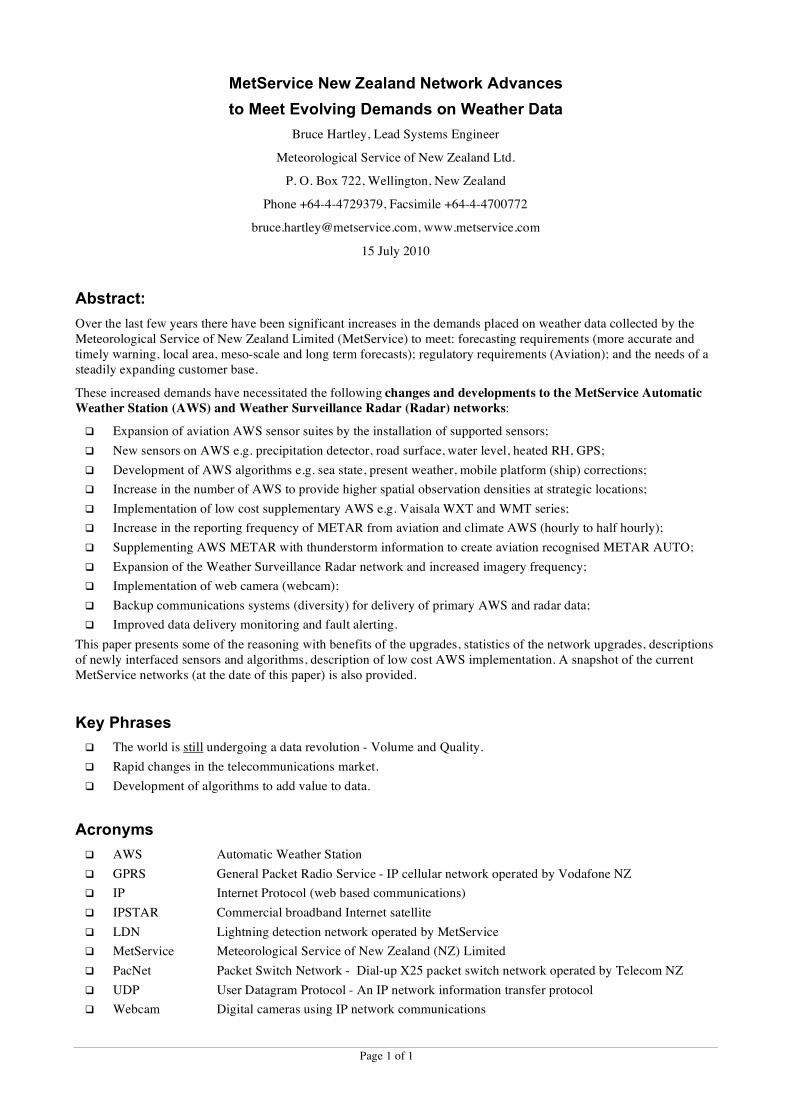
Summary
The last 5 years have seen unprecedented growth and feature changes in the networks managed by MetService. These changes were driven by evolving demands on weather data (forecast and customer requirements), rapid changes in telecommunications, manual observation cost, and an expanding customer base e.g. Airways Corporation NZ, NZ Transport Agency, NZ Coast Guard, NZ Department of Conservation, energy companies, port operators, private airport operators, regional and local government.
Network Expansion:
! AWS: 79 in 2005, 150 now, 171 by the end of 2010
! Weather Radar: 5 in 2008, 7 in 2010, 9 in 2012
! Webcam: 4 in 2010
Additional Functionality:
! AWS sensors: Precipitation (DRD), Road (ROSA + Lufft), Sea state (microwave), Heated RH (HMP155),
GPS, Low cost (WXT/WMT), Ultrasonic wind.
! AWS algorithms: Sea state analysis, AWS on a moving platform, DRD rainfall, Visibility and RH
to present weather, present weather combine, present to recent weather.
! Weather Radar: Non-Doppler to Doppler (NV 2005), Wind finding to weather surveillance (NP 2008)
Image frequency double
! Monitoring: Improved data delivery monitoring and fault alerting
Communications Changes:
! Prior to 1980: Telex, ARGOS
! 1980 to 2005: Telex, Dialup PacNet, Leased line, MTSAT, ARGOS, AFTN
! 2005 to 2010: Cellular, DSL, LAN, commercial satellite (IPSTAR), <- all Broadband
Cellular, Dialup IP, Radio modem, Iridium, MTSAT, ARGOS, AFTN
Dual path communications
Aviation AWS Upgrades:
! METAR: 12 Manual stations cease, 20 METAR AUTO (including TS) start in 2008/2009
! AWS: 1 minute real time data updates, changing from hourly to half hourly METAR
! AWS: 16 ceilometers, 20 visibility + present weather, 8 precipitation detectors in 2008/2009
Illustration of network/communications growth for cellular communications:
! 2004 to 2010 Stations operated for customers grows from 6 to 58 (79 by end of 2010)
! 2007 AWS time synchronisation implemented
! 2008 64 stations converted from PacNet to DSL and/or GPRS (Backup communications)
Page 3 of 3
Network Expansion
In recent times MetService weather forecast customers have required increases in frequency, resolution and accuracy of forecasts (warning, public and commercial). Other organisations have also experienced increasing demands on weather data to meet their own operational and prediction requirements, some of these organisations have engaged MetService to install and operate AWS for them and provide a contracted data service.
During this time there have also been significant beneficial changes in weather sensor features and costs, and
telecommunications equipment and services.
These demands and changes have provided the stimulus and business cases for the expansion of the MetService AWS and Weather Radar networks, as well as increased data reporting frequencies and implementation of techniques to improve data delivery reliability. The cost benefit has even reached the point where it is possible to split one fully configured AWS with compromised exposure into two stations, each with a reduced sensor suite but with more representative exposures.
The increasing value of visual data and the implementation of broadband communications has meant that web cameras have become cost effective to purchase and operate.
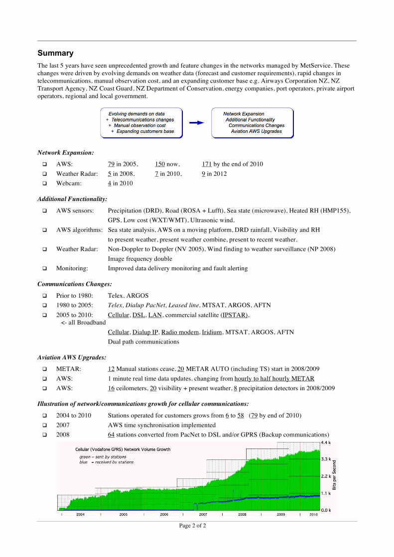
Automatic Weather Stations 79 in 2005, 150 now, 171 by the end of 2010
The expansion to now has comprised: 23 Forecasting & Aviation; 48 Customer.
The advent of low cost fixed configuration AWS has made possible the installation of AWS as gap
fillers that would have otherwise not been justifiable. These AWS e.g. Vaisala WXT and WMT series, measure only core weather forecast data parameters and have some compromises in exposure, however they are fit for purpose. These AWS have been configured to send simple 1 minute data summaries at 1 minute intervals similar to other MetService AWS. Sending such simple
messages has required the implementation of algorithms on the central server to create longer period data values i.e. averages, maxima, minima, accumulated totals. These derived data processing algorithms are the same as implemented on AWS i.e. the same derived data processing is performed on AWS for supply of full data sets locally or when sending in messages (METAR, SYNOP etc.) at less frequent intervals e.g. half hourly or hourly.
For AWS 1 minute messaging the message sizes are typically: Non-aviation 250 characters; Aviation 500 characters. This gives monthly volumes of typically 11 to 22 MB
Minimum volume billing per connection provides a cost per AWS as typically:
! Vodafone cellular NZ$ 12
! Telecom Cellular NZ$ 6
! DSL NZ$ 110
! IPSTAR NZ$ 140
AWS Network 2005

0 100 200100
Kilometres
Copyright Meteorological Service of New Zealand Limited. Commercial in Confidence.
Brothers Is NZBRX S1/ms
WX/ms NZGAX Galatea
Total AWS excluding 3rd party (150)
WX/ms NZTBX Tolaga Bay
IS/ms NZWKA Whakatane Aiport
MR/cl NZTOX Te Haroto
MP/cs NZNRT Napier City
WX/ms NZCTX Cape Turnagain
IS/ms NZAPA Taupo Aiport
IE/ms NZLUX Lumsden
S1/ms NZMUX Mokohinau IsMP/cs NZCLW Channel Is
WX/ms NZFHX Flat Hills
IP/ms NZSGX Sugarloaf Tower
MP/cl NZMDX Mid Dome
WX/cl NZWOX Waiouru North
MP/ms NZJTX Taumarunui
IP/cl NZCAW Aotea WharfMP/cl NZCUX Burnham Wharf
IP/ms NZKLX Kelburn
MR/cl NZDRT Desert Road Summit
MR/cl NZKJX Kurutau Junction
IS/ms NZGSA Gisborne Aiport
MP/cl NZTHA Tauhara
Hawera NZHAX IS/ms
WX/ms NZGVX Golden Valley Wahi
WX/ms NZCKX Cape Kidnappers
IS/ms NZDNA Dunedin Aiport
Wanganui Aiport NZWUA IE/ms
Stratford Mountain Club NZSMX WX/cs
MP/cl NZCFX Front Lead
MP/cl NZTTX Tongariro
MR/cl NZHLX High Level Road
WX/ms NZMAX Mahia Radar
????? ZM___ ?????
IE/ms NZLBX LeBons Bay
MP/cs NZOUT Oamaru
Wanganui Dst Cncl NZWUT MP/cs
Farewell Spit NZFSX S1/ms
Ohakea Aiport NZOHA IP/ms
IS/ms NZROA Rotorua Aiport
Takaka Hill NZTAX MP/cl
????? NZ___ Rimituka Hill South
WX/cl NZAHX Aqueduct HillMR/cl NZNTX National ParkMR/cl NZSWX South Waiouru
IS/ms NZNRA Napier Aiport
Levin NZLNX IS/ms
MP/cl NZERX East Rangataiki
MP/cs NZLYX Lyttleton
Paeroa NZPAX S1/ms
FRV Tangaroa ZMFR SS/ms
MP/ms NZSLW Slipper Is
MP/ms NZTKX Takapau
Stephens Is NZSPX MP/ms
Maui Platform A NZ___ ?????
New Plymouth City NZNPT MP/csNew Plymouth Aiport NZNPA IS/ms
S1/ms NZHIX Hicks Bay
IS/ms NZTGA Tauranga Aiport
MP/cs NZKWX Kawerau
Satellite (8)
AFTN (1)
Possible new stations (30)
IP / ms iSTAR-PC (13) IP / cl iSTAR-PC (2) IP / cs iSTAR-PC (1) IS / ms iSTAR-Sutron (29) IE / ms iSTAR-EGG (11) IM / ms iSTAR-mSTAR (1) S1 / ms SUTRON-1min (7) SS / ms SUTRON-Satellite (8) MP / ms mSTAR-Pro (10) MP / cl mSTAR-Pro (14) MP / cs mSTAR-Pro (22) MR / cl mSTAR-Rosa (6) MS / ms mSTAR-Ship (1) WX / ms WXT... (13) WX / cl WXT... (4) WX / cs WXT... (3) WM / ms WMT... (1) WM / cs WMT... (4) DX / ms IDAS Interrogator (1) / ms MetService AWS (95) / cl Customer Lease AWS (28) / cs Customer Sold AWS (30) Third Party Interrogated (7)
Excludes overseas, test, demo, short term lease.
AWS Key
AWS Information Last Updated: 15 July 2010
Meteorological Service of New Zealand Ltd
Automatic Weather Station (AWS) Network
Cape Reinga NZCRX IS/ms
Kaipara Harbour NZKHW MP/cs
Kaitaia Hospital NZJKX IP/cs
Hokianga NZHOX WX/cs
Tiritiri Light NZTTW MP/csWhangaparoa NZWHX IE/ms
Whenuapai Aiport NZWPA IP/msAuckland Aiport NZAAA IS/ms
Manakau Heads NZMKW MP/cs
Hamilton Aiport NZHNA IP/ms
Port Taharoa NZTRX IE/ms
Otaki NZOCT MP/csParaparaumu Aiport NZPPA IS/ms
Nelson Aiport NZNSA IS/ms
Kawatiri Road NZKAX MP/clWestport Aiport NZWSA IS/msCape Foulwind NZFWW WM/ms
Hokitika Aiport NZHKA IS/ms
Haast NZHTX IE/ms
Tara Hills NZTHE IS/ms
Milford NZMFA IP/ms
Secretary Is NZSCX SS/ms
Manapouri Airport
NZMOA IS/ms
Puysegur Point NZPYX SS/ms
South West Cape NZSIX SS/ms
Raoul Is NZRNX SS/ms
Chatham Is NZWAX IS/msSS/ms NZEDX Enderby Is
SS/ms NZCBX Campbell Is SS/ms NZCMX Campbell Is
IE/ms NZPEX PureruaMP/cs NZBIT Bay of IslandsMP/cs NZOKW Okahu Is
MP/cs NZTKW TutukakaIS/ms NZWRA Whangarei Airport
MP/cs NZBNW Bean RockMP/cs NZPRW Passage Rock
MP/ms NZWTA Whitianga Aiport
MP/ms NZWIX White Island
S1/ms NZMHX Mahia
MP/cs NZHST Hastings City
IS/ms NZPMA Palmerston North Aiport
S1/ms NZCPX Castlepoint
MP/ms NZMNX Mana Is
MP/cl NZRIX Rimituka Hill Summit
IE/ms NZNWX Ngawihi
MP/cs NZKRW Tongue Point
IE/ms NZCCX Cape CampbellIS/ms NZWBA Blenheim Aiport
IS/ms NZKIX KaikouraMP/cs NZKIT Kaikoura Aiport
IS/ms NZCHA Christchurch Aiport
MP/ms NZASA Ashburton
IS/ms NZTUA Timaru Aiport
Wanaka Aiport NZWFA IS/ms
IP/ms NZOUA Oamaru AiportQueenstown Aiport NZQNA
IS/ms
MP/cs NZDNX Dunedin City
IM/ms NZGCE Gore
IE/ms NZNGX Nugget Point
IS/ms NZNVA Invercargill Aiport
Radio Modem First Link (5)
MP/cs NZKAW Cape KarikariMetService Intranet (1)
IS/ms NZWNA Wellington Aiport
MP/cl NZCSW Seaview Wharf
Port Taharoa Buoy NZPTB
IP/ms NZKKW Mount Kaukau
IP/ms NZARA Ardmore Aiport
Kaitaia Aiport NZKTA WX/ms
Kerikeri Aiport NZKKA IP/ms
WX/ms NZNBX New Brighton Pier????? NZNBB New Brighton Pier
Pukakai Aiport NZUKA IP/ms
IP/ms NZMSA Masterton Aiport
IP/ms NZSSX Swampy Summit
Kaikohe NZKOE MP/ms
WM/cs NZGMW Great Mercury Is
Broadband OfficeAnywhere only (9)
Dialup OfficeAnywhere only (1)
GPRS & DSL OfficeAnywhere (31)
GPRS & Dial-in Interogate (1)
WM/cs NZRPW Ruapuke Island
MP/cl NZTEX Te Pohue
GPRS & MetService Intranet (1)
2
3 4
5
Separation Point NZSEW ????? 1
Centre Island NZCNW WM/cs
WM/cs NZMXW Moeraki
IPStar OneOffice only (3)
MS/ms ZMENA Spirit of Endurance
GPRS & Dialup OfficeAnywhere (2)
WX/ms NZRXX Roxburgh
WX/ms NZFAX Fairlie
WX/ms NZCUA Culverden
WX/cl NZAQX Aotea Quay
WX/cl NZRPX Rimituka Pages Point
NZNOW Newlands OffRampIP/cl NZHJX Jville Helston
IE/ms NZRUX Waiouru
MP/cl NZMRX MoturoaMP/cl NZMGX Mangatepopo Road
MP/cl NZRTX Raetahi
MP/cs NZMPX Whangarei NZ Refinery
Paraparaumu Aiport NZXAX MP/ms
WX/cs NZAPX Taupo District Council
Cellular Vodafone GPRS only (86)
Birchwood NZBWX WX/ms
Coast Guard NZ___ ?????
Kaimai NZKNX ?????
D1/ms Christchurch Aiport
Kopu East NZKEX ?????
????? NZKXX KoromikoWestport NZWQX ?????
Springs Junction NZSJX ?????
Hokitika South NZHHX ?????
67
????? NZHUX HurunuiPorters Pass NZPTX ?????
Fox Glacier NZFGX ?????
????? NZMVX Methven
????? NZCPX Cooptown
Tekapo NZTXX ?????
Cluden Hill NZCLX ?????
Shotover NZSOX ?????
????? NZWEX Wedderburn
????? NZMLX Millers Flat
????? NZWZX Waitati
????? NZWXX Waipahi
????? NZBCX Balclutha
????? NZWLX Wallacetown
????? NZOKX Omakau
D1 Christchurch
Airport Interrogates: 1 NZTOF Totaranui 2 NZKEF Kenepuru Head 3 NZMRF Murchinson 4 NZLEF Lake Rotoiti 5 NZMLF Molesworth 6 NZSDF Snowdon 7 NZDRF Darfield
Cellular Telecom-XT only (3)
Page 5 of 5
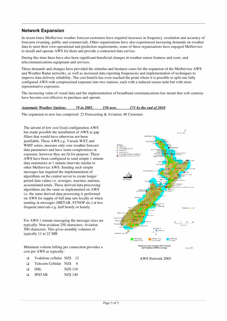
Weather Surveillance Radar network 5 in 2008, 7 in 2010, 9 in 2012
Increasing demands on the mesoscale and short range forecast warnings has been the driver for upgrading (refer to the section “Additional Functionality” below) and expanding the MetService weather surveillance radar network by installation of four new weather surveillance radar, 1 in each year 2009, 2010, 2011, 2012.
Note: All radar in the 2005 image below were Doppler capable but a coverage drawing has not been included.
Network expansion (dashed circles show the planned coverage for 2012)…
Non Doppler coverage - 2005 Non Doppler coverage - 2010 Doppler coverage - 2010
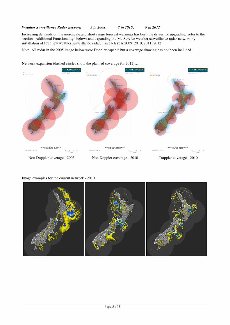
Image examples for the current network - 2010
Page 6 of 6
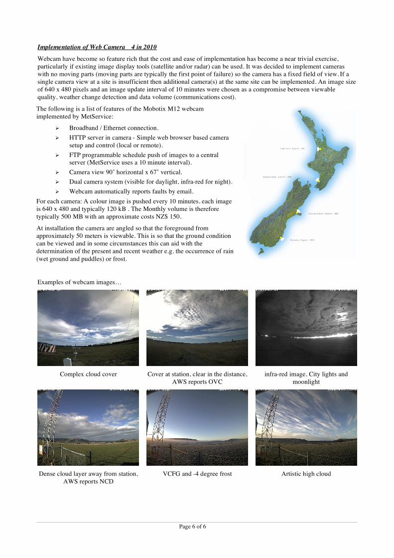
Implementation of Web Camera 4 in 2010
Webcam have become so feature rich that the cost and ease of implementation has become a near trivial exercise, particularly if existing image display tools (satellite and/or radar) can be used. It was decided to implement cameras with no moving parts (moving parts are typically the first point of failure) so the camera has a fixed field of view. If a single camera view at a site is insufficient then additional camera(s) at the same site can be implemented. An image size of 640 x 480 pixels and an image update interval of 10 minutes were chosen as a compromise between viewable quality, weather change detection and data volume (communications cost).
The following is a list of features of the Mobotix M12 webcam implemented by MetService:
" Broadband / Ethernet connection.
" HTTP server in camera - Simple web browser based camera setup and control (local or remote).
" FTP programmable schedule push of images to a central server (MetService uses a 10 minute interval).
" Camera view 90˚ horizontal x 67˚ vertical.
" Dual camera system (visible for daylight, infra-red for night).
" Webcam automatically reports faults by email.
For each camera: A colour image is pushed every 10 minutes, each image is 640 x 480 and typically 120 kB . The Monthly volume is therefore typically 500 MB with an approximate costs NZ$ 150.
At installation the camera are angled so that the foreground from approximately 50 meters is viewable. This is so that the ground condition can be viewed and in some circumstances this can aid with the determination of the present and recent weather e.g. the occurrence of rain
(wet ground and puddles) or frost.
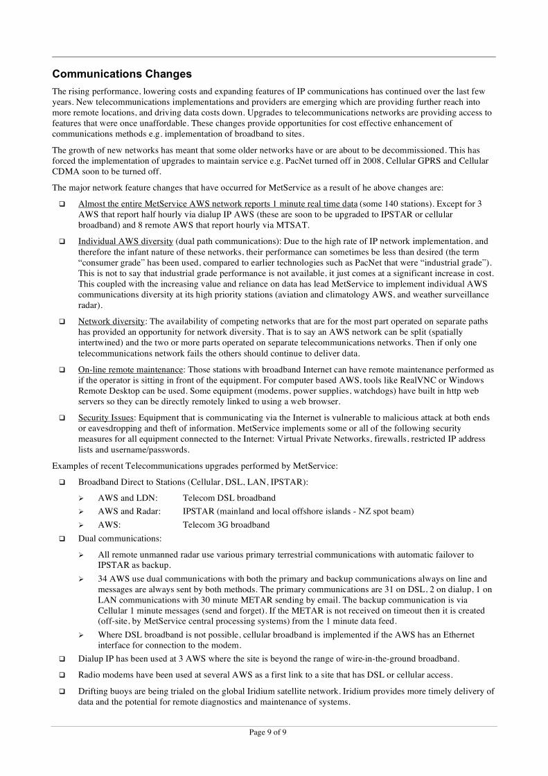
Examples of webcam images…
Complex cloud cover
Cover at station, clear in the distance, AWS reports OVC
infra-red image, City lights and moonlight
Dense cloud layer away from station, AWS reports NCD
VCFG and -4 degree frost
Artistic high cloud

Page 7 of 7
The camera horizontal view direction (90˚ wide) is pointed to where the most significant weather comes from at each station (determined by aviation forecasters).
Webcam typical elevation view
Additional Functionality
New AWS Sensors:
Over the last 5 years various demands on weather data have driven the implementation of sensor technologies not previously used by MetService. The following is a list of these sensors with the primary reason for the implementation:
! Precipitation (DRD) Aviation AWS with visibility upgraded to present weather.
! Road (ROSA + Lufft) Customer requirement.
! Sea state (microwave) Customer requirement.
! Heated RH (HMP155) RH data quality improvement near 100 %RH.
! GPS (various) Ship AWS implementation. Satellite time slot synchronisation.
! Low cost (WXT/WMT) Network gap fillers and customer sales. Stand alone and add-on to other AWS.
! Ultrasonic wind (WS425, Windsonic, WXT, WMT) Improved reliability (sensors have no moving parts).
New AWS Algorithms:
New algorithms have been developed by MetService to support the implementation of new sensors and data
requirements. The following is a brief description of each algorithm (more detail at the end of this paper):
! Sea state analysis: The water level from a downward pointing microwave sensor is processed over 512 one second samples (an 8.6 minute sample window) to derive traditional (scalar based) and spectral (energy based) sea state characteristics.
! Moving platform: The implementation of a stand alone AWS on a ship (the AWS is not connected to any ship data system) required the use of GPS and the computation of ship location, Course over Ground (COG), Speed Over Ground (SOG), and the correction of ship relative winds to True North relative values. Detection of exception conditions was incorporated e.g. ship near stationary. No allowance was made for ship roll or ship course difference from COG due to cross wind components or ocean currents.
! DRD rainfall: 1) The Vaisala DRD precipitation detector was interfaced to an AWS and an algorithm developed to convert the DRD analogue voltages to rainfall intensity in mm per hour. Due to the susceptible nature of the sensor to contamination the algorithm includes self calibration at both the dry and high rainfall rate ends of operation. 2) As the sensor has a high uncertainty the intensities are time processed and converted to the METAR qualitative values of –RA, RA, +RA (last 15 minutes data) and –SHRA, SHRA, +SHRA (last 60 minutes data) using a Rain Intensity to Present Weather algorithm.
! Visibility and relative humidity to present weather: This algorithm uses 1 minute average relative humidity (in %RH) and 10 minute average visibility (in meters) data to determine a METAR type present weather as follows:
Vis < 1000 1000 ! Vis ! 5000 Vis > 5000
RH ! 95 HZ //
RH > 95 FG BR //

Page 8 of 8
! Present weather combine: Due to additional data sources and algorithms it is possible for an AWS to have multiple present weather data sources. It is therefore necessary to have an algorithm to quality control and combine these various sources, and where relevant to prioritise the sources i.e. in case conflicting present
weather are available.
! Present to recent weather: Due to limitations found in the recent weather provided by present weather sensors e.g. non-programmable time period, and as MetService has implemented other present weather algorithms, a present weather to recent weather algorithm was developed. The algorithm uses the current present weather and the present weather from 15 (or 16) minutes ago, restricts the values to precipitation only, then applies the WMO METAR coding rules for recent weather.
Handar with Precipitation Detector
Road Weather Station
Sea state sensor housing
Weather Radar Changes: Non-Doppler to Doppler, Wind finding to weather surveillance, Image frequency double
The increasing demands that drove the weather radar network expansion also provided justification to upgrade one radar from non-Doppler to Doppler (Invercargill 2005) and to upgrade one wind finding only radar to a weather surveillance radar (New Plymouth 2008). Both these radar are still used for wind finding flights three times a day and during these periods totalling about 3 hours at each location no weather surveillance imagery is available.
The increasing demands, coupled with improvements in hardware, have made it cost effective to double the full volume scan frequency (scan interval decreased from 15 to 7.5 minutes). Appropriate infrastructure changes (telecommunications and central processing and archiving) were also implemented to handle the increased data/image rates and volumes.
Improved Data Delivery Monitoring and Fault Alerting:
MetService is continually looking for, developing and implementing upgrades to its network monitoring systems. Enhancements may be in the form of improved network statistics, simple self alerting from a piece of equipment, or equipment that monitors other equipment and perform remedial actions under fault conditions (a watchdog). As a result of recent equipment implementations and functionality changes the following have been implemented:
! Additional sensor status information included with 1 minute messages during warning and alarm conditions.
! Central software monitors all AWS messages and generates hourly summaries of: Warnings and alerts from AWS; 1 minute and METAR delivery statistics; Alerts on missing stations.
! LDN: Improved remote access with the upgrade from PacNet to DSL broadband.
! Devices such as: Uninterruptible Power Supply; Webcam; DSL router; IPSTAR router; Cellular modem
" Simple web browser based setup and control (local or remote)
" Automatic alert emails of alarm conditions
! IP Watchdog
" Communications monitor and modem/router reset on timeout
Page 9 of 9
Communications Changes
The rising performance, lowering costs and expanding features of IP communications has continued over the last few years. New telecommunications implementations and providers are emerging which are providing further reach into more remote locations, and driving data costs down. Upgrades to telecommunications networks are providing access to features that were once unaffordable. These changes provide opportunities for cost effective enhancement of communications methods e.g. implementation of broadband to sites.
The growth of new networks has meant that some older networks have or are about to be decommissioned. This has forced the implementation of upgrades to maintain service e.g. PacNet turned off in 2008, Cellular GPRS and Cellular CDMA soon to be turned off.
The major network feature changes that have occurred for MetService as a result of he above changes are:
! Almost the entire MetService AWS network reports 1 minute real time data (some 140 stations). Except for 3 AWS that report half hourly via dialup IP AWS (these are soon to be upgraded to IPSTAR or cellular broadband) and 8 remote AWS that report hourly via MTSAT.
! Individual AWS diversity (dual path communications): Due to the high rate of IP network implementation, and
therefore the infant nature of these networks, their performance can sometimes be less than desired (the term “consumer grade” has been used, compared to earlier technologies such as PacNet that were “industrial grade”). This is not to say that industrial grade performance is not available, it just comes at a significant increase in cost. This coupled with the increasing value and reliance on data has lead MetService to implement individual AWS communications diversity at its high priority stations (aviation and climatology AWS, and weather surveillance radar).
! Network diversity: The availability of competing networks that are for the most part operated on separate paths has provided an opportunity for network diversity. That is to say an AWS network can be split (spatially intertwined) and the two or more parts operated on separate telecommunications networks. Then if only one
telecommunications network fails the others should continue to deliver data.
! On-line remote maintenance: Those stations with broadband Internet can have remote maintenance performed as if the operator is sitting in front of the equipment. For computer based AWS, tools like RealVNC or Windows Remote Desktop can be used. Some equipment (modems, power supplies, watchdogs) have built in http web servers so they can be directly remotely linked to using a web browser.
! Security Issues: Equipment that is communicating via the Internet is vulnerable to malicious attack at both ends or eavesdropping and theft of information. MetService implements some or all of the following security measures for all equipment connected to the Internet: Virtual Private Networks, firewalls, restricted IP address
lists and username/passwords.
Examples of recent Telecommunications upgrades performed by MetService:
! Broadband Direct to Stations (Cellular, DSL, LAN, IPSTAR):
" AWS and LDN: Telecom DSL broadband
" AWS and Radar: IPSTAR (mainland and local offshore islands - NZ spot beam)
" AWS: Telecom 3G broadband
! Dual communications:
" All remote unmanned radar use various primary terrestrial communications with automatic failover to IPSTAR as backup.
" 34 AWS use dual communications with both the primary and backup communications always on line and messages are always sent by both methods. The primary communications are 31 on DSL, 2 on dialup, 1 on LAN communications with 30 minute METAR sending by email. The backup communication is via Cellular 1 minute messages (send and forget). If the METAR is not received on timeout then it is created (off-site, by MetService central processing systems) from the 1 minute data feed.
" Where DSL broadband is not possible, cellular broadband is implemented if the AWS has an Ethernet interface for connection to the modem.
! Dialup IP has been used at 3 AWS where the site is beyond the range of wire-in-the-ground broadband.
! Radio modems have been used at several AWS as a first link to a site that has DSL or cellular access.
! Drifting buoys are being trialed on the global Iridium satellite network. Iridium provides more timely delivery of data and the potential for remote diagnostics and maintenance of systems.

Page 10 of 10
Aviation AWS Upgrades
Increasing value/reliance on data availability for the aviation community (time density, time coverage, reliability), and the ability to make cost efficiencies have driven a change from manual observations at aerodromes to more frequent AWS generated METAR AUTO. To meet data quality demands for these stations they were upgraded by the installation of: additional sensors including ceilometers, visibility + present weather and precipitation detectors; the implementation of webcams; and development of present weather algorithms. The resulting increased reliance on the
AWS data meant stations need to be upgraded to dual communications (with separate paths).
Detail of the changes are as follows:
! The METAR report frequency from aviation and climate AWS has been increased from hourly to half hourly;
! All aviation AWS now report 1 minute real time data as backup via a separate communications path.
! Aviation AWS METARs are enhanced by the addition of lightning counter data as TS or VCTS as follows:
" TS is added to the METAR present weather if there were > 1 lightning counts within 8 km radius from the Aerodrome reference point.
" VCTS is added to the METAR present weather if there were > 1 lightning counts outside 8 km and within 16 km radius from the Aerodrome reference point.
! 16 Aviation AWS without ceilometers had CL31 sensors installed. The MetService-implemented USA National Weather Service ASOS sky condition algorithm produces METAR coded cloud for inclusion in reports from these stations.
! 8 ageing Handar visibility sensors were replaced with present weather sensors (the Handar were relocated). Some AWS without visibility/present weather sensors were upgrade full present weather + visibility. In total 11 of the PWD22 and 9 of the FD12P new sensors were installed.
! The Handar visibility sensors were relocated to sites with less stringent data requirements. These AWS had a DRD precipitation detector added and the MetService developed DRD + visibility + relative humidity to present
weather algorithms implemented to create a "low cost" present weather sensor.
! An additional 2 strategic AWS were installed that could provide supplementary data, in particular upper level winds, through the METAR remark at a nearby aviation AWS.
! After all of the above were in place it allowed the start of 26 METAR AUTO and the cessation of 14 comprehensive manual METAR. The only manual remaining manual METAR programmes are at Auckland, Wellington and Christchurch International Airports and at two Royal New Zealand Airforce (RNZAF) bases.
Near Future
MetService is continually looking for, developing and implementing upgrades to its network systems. Current projects include investigation and/or implementation of the following:
! 2 sites that currently use dialup IP will be upgraded to cellular broadband once the chosen modem has been approved for use in NZ.
! The remaining site that currently uses dialup IP will be upgraded to IPSTAR broadband.
! Most radio modem links used as first links to DSL or cellular accessible modems will be replaced with direct cellular communications. A recent upgrade of the Telecom NZ cellular network has removed the approximate 32 km range limit from cell sites enabling most radio modem sites to soon connect directly to cellular networks.
! Replacement of ageing satellite reporting solar powered AWS at very remote locations.
! Improved quality control and alarm reporting in AWS using data parameter cross checking algorithms.
! Upgrade of calibration systems for newly implemented sensors.
! Further network expansion as budgets allow.

Page 11 of 11
Algorithm: Sea State
Traditional Analysis (zero crossing)
TrLvl Traditional analysis average water level. Usually above Datum
Hs/Hsig Significant wave height = average height of the waves which comprise the highest 33% of waves
Hmax Maximum wave height in a recorded burst of raw data
H10 Average height of the waves which comprise the top 10%
Tz Zero crossing period = mean period
Ts / Tsig Significant period = average period of the waves used to define Hsig
Spectral Analysis (Fourier)
SpLvl Spectral analysis DC water level. Usually above Datum
TP1/Tp Period of the peak of the energy spectrum
HP1 Height of the peak of the energy spectrum
TP2 Period corresponding to the second biggest peak of the energy spectrum
HP2 Height corresponding to the second biggest peak of the energy spectrum
A resolution of 2 decimal places for tide and 1 decimal place for other values is used.
The 1 second raw data is saved in a rolling 512 second (8.6 minute) wave data record.
Traditional Analysis: The Traditional analysis is performed once every minute on the rolling 512 second (8.6 minute) wave data record. The data parameters are extracted for sending at this point.
Spectral Analysis: The Traditional analysis average water level is subtracted from each point in the 512 wave data record (so the TrLvl and the SpLvl are currently both the TrLvl). The data is then filtered (Hanning filter) to remove abrupt changes at the beginning and end of the data sequence. The data record is then passed through the FFT and Tp1/Tp2 and Hp1/Hp2 are extracted.
Note: The HP1 and HP2 data are calculated as Power by finding the spectral peak and root mean squaring the sums of the adjacent energy to the peak. If the spectra are relatively pure (e.g. one or two frequencies) only the energy greater
than 10% of the peaks in adjacent frequency bins contributes to Hp1/Hp2. For more complex waves the energy >50% of the first peak and greater than the trough between the two peaks can contribute to the energy summed in Hp1 and Hp2.

Page 12 of 12
Algorithm: Rainfall Intensity to METAR Present Weather
This algorithm is performed once per minute on an array of 60 one minute rainfall intensity (RI) values.
The last 15 minutes data is used to determine the present weather type (raining or not raining) and intensity, and the last 60 minutes data is used to determine if the rain is occurring as showers.
Determine raining in the last 15 minutes
Within the last 15 minutes rainfall intensity (RI) data if there are ! 12 minutes valid data then
If ( latest minute RI > 8.0 mm/hour ) Or ( ! 3 minutes with > 8.0 mm/hour ) Then
PrWx = +RA
ElseIf ( latest minute RI > 2.0 mm/hour ) Or ( ! 3 minutes with > 2.0 mm/hour ) Then
PrWx = RA
ElseIf ( latest minute RI > 0.0 mm/hour ) Or ( ! 3 minutes with > 0.0 mm/hour ) Then
PrWx = -RA
Else
PrWx = Blank
End
Determine if Showers: 2 or More transitions between Raining and Not Raining in the last 60 minutes
If ( PrWx = -RA ) Or ( PrWx = RA ) Or ( PrWx = +RA ) Then
Transition count = 0
For each minute x with valid RI(x) from 60 minutes ago to now
If ( RI(x) = 0.0 mm/hr ) And ( RI(x-1) > 0.0 mm/hr ) Then
Found NotRaining-to-Raining so increment the Transition count
ElseIf ( RI(x) > 0.0 mm/hr ) And ( RI(x-1) = 0.0 mm/hr ) Then
Found Raining-to-NotRaining so increment the Transition count
End
Next
If Transition count ! 2 Then
Change the PrWx so that SH is included in the correct place
End
End

Page 13 of 13
Algorithm: Present Weather to Recent Weather
This algorithm is performed once per minute on 1 minute present weather values are retrieved from the database
PrWx(now) is the current METAR present weather (up to 3 groups)
PrWx(-15) is the METAR present weather from 15 minutes ago (up to 3 groups)
The software is allowed to scan back 1 minute in the database if no valid present weather has been retrieved.
Both PrWx(now) and PrWx(-15) are parsed and restricted to:
[+/-]FZDZ [+/-]FZRA
[+][SH]RA [+][SH]SN [+][SH]GR [+][SH]GS
[+]DZ, [+]SG [+]PL
If PrWx(-15) contains any item(s), including intensity differences, that are not in PrWx(now) then
Put the PrWx(-15) item(s) into ReWx(now)
Tidy up the ReWx(now) groups so that they meet the METAR coding rules
EndIf
Examples.
If PrWx(now) = FZDZ and PrWx(-15) = RA then ReWx(now) = RERA
If PrWx(now) = SHRA and PrWx(-15) = SHRASN then ReWx(now) = RESHSN
If PrWx(now) = SN and PrWx(-15) = SN then ReWx(now) = ""
If PrWx(now) = +SN and PrWx(-15) = SN then ReWx(now) = RESN
If PrWx(now) = SN and PrWx(-15) = +SN then ReWx(now) = RESN
If PrWx(now) = -SN and PrWx(-15) = SN then ReWx(now) = RESN
If PrWx(now) = -SN and PrWx(-15) = +SN then ReWx(now) = RESN
If PrWx(now) = SN and PrWx(-15) = -SN then ReWx(now) = “”
If PrWx(now) = +SN and PrWx(-15) = -SN then ReWx(now) = “”
Note: items enclosed in [ ] are optional. items separated by / indicate one option or another.
End