metropolitan countryside - planning.vic.gov.au · controls which identify farming, ... farming aim...
TRANSCRIPT

MELBOURNE STRATEGY IMPLEMENTATION
METROPOLITAN COUNTRYSIDE
The metropolitan countryside strategic objectives seek to ensure permanent retention of wedges of countryside between the urban corridors. These wedges ensure that scenic landscapes, farming areas, native vegetat ion and w i ld l i f e habi tats are preserved within the metropolitan area.
These areas help satisfy people's needs for fresh vegetables and other primary products and provide opportunities for hobby farming and areas where people can 'escape' from the city. They also contain extractive resources such as topsoil, clay, gravel, sand and stone.
The Board's previous reports, 'Review of Planning Policies for the Non-Urban Zones' and the 'Metropol i tan Farming Study' published in 1977, describe in detail the resources and issues of the countryside wedges.
16.1
Clear Demarcation Between Urban and Rural
The Metropolitan Strategy continues the Board's present policies. These are to maintain a clear demarcation between urban and non-urban areas, to eliminate urban expectations from rural areas, to encourage rural enterprises and to facilitate the use of particular areas in accord with their land capability. The strategy also continues the policy that land used for mineral and stone extraction must be restored for after-use compatible wi th nearby activities.
By removing urban expectations from non-urban areas, the planning strategy aids their survival. It also helps eliminate both land speculation and the sort of development that leads to uneconomic demand for urban services.
Maintaining a rural landscape which is productive, protective of natural resources
85

and visually attractive depends to a large extent on well managed, privately owned properties large enough to sustain particular rural uses. Rural planning wi l l continue to aim at matching land uses to physically suitable areas without detriment to the land, and to m a i n t a i n i n g a l l o t m e n t s izes appropriate to sound land management. The Board wi l l continue its liaison and advisory service on rural issues.
16.2 Natural Conservation and Protection of the Metropol i tan Countryside
Since 1971, the Board's rural policies have promoted a series of countryside zones and controls which identify farming, landscape and conservat ion areas. These have stabil ised the rural areas by l imi t ing subd iv is ion and prov id ing reasonable controls over a range of uses.
The strategic objectives relating to the met ropo l i tan count rys ide and natura l conservat ion emphasise the need to conserve resources of soil, flora, fauna and areas of high landscape value. The objectives also require the maintenance and protection of streams, floodways and significant mineral resources.
Continuing study of the relationships between land-use, farming controls, social factors and the performance of natural resource systems has shown a need for further refinement of such issues as:
• need for an increased subd iv is ion minimum for broadscale farming areas
• extension of countryside wedges into former corridors not now needed for future urban development
• further refinement of controls in respectto protection of environmental quality
• problems caused by development of existing small vacant lots in rural areas
• demand and supply of rural lots for residential use.
New zones are provided in which the a l lowable m i n i m u m size of lots in subdivisions wi l l be larger than in existing zones. These changes main ly af fect broadscale farming areas north and west of Melbourne. An Intensive Agriculture Zone applies to an area at Clyde suited to market gardening on a broad scale.
Amendment 150 also includes provisions that reflect the nature and capability of the land. The provisions include specifying minimum lot sizes for subdivision and
refining criteria for assessing land use proposals.
The Board wi l l continue its close liaison wi th the rural community and appropriate authorities. It wi l l continue to monitor the development of resources of the non-urban zones of the metropolitan area, and prepare guidelines for development and managment of non-urban land.
16.3 Broadscale Farming
The Board supports the continuance of broadscale pastoral and cropping uses in areas north and west of Melbourne. Land best suited to these uses is at present in General Farming and Corridor Zones. Much of it is farmed in large units and held in allotments of over 80 hectares.
Farm sizes needed for broadscale pastoral and cropping uses are far larger than the minimum subdivision sizes now allowed in General Farming and Corridor Zones. Prime pastoral land in parts of the Corridor Zones has been broken down into 1 2 hectare lots. Studies show that these small farmlets have caused management problems for the new owners and residents and have had severe impact on neighbouring farms. The most obvious problems include increased erosion hazard, noxious weeds, vermin, fire hazards and marauding dogs.
The General Farming 'B' and Corridor 'B' and ' C Zones raise the minimum lot sizes and provide for farming and related activities.
The proposals for metropolitan broadscale farming aim to relieve subdivision pressure, encourage farmers to stay on their land, retain farming enterprise and maintain an attractive productive rural environment.
86
HUHStBMDQE
WARnAhOYTE %
PORT PHILLIP BA)
CMHBOMHt
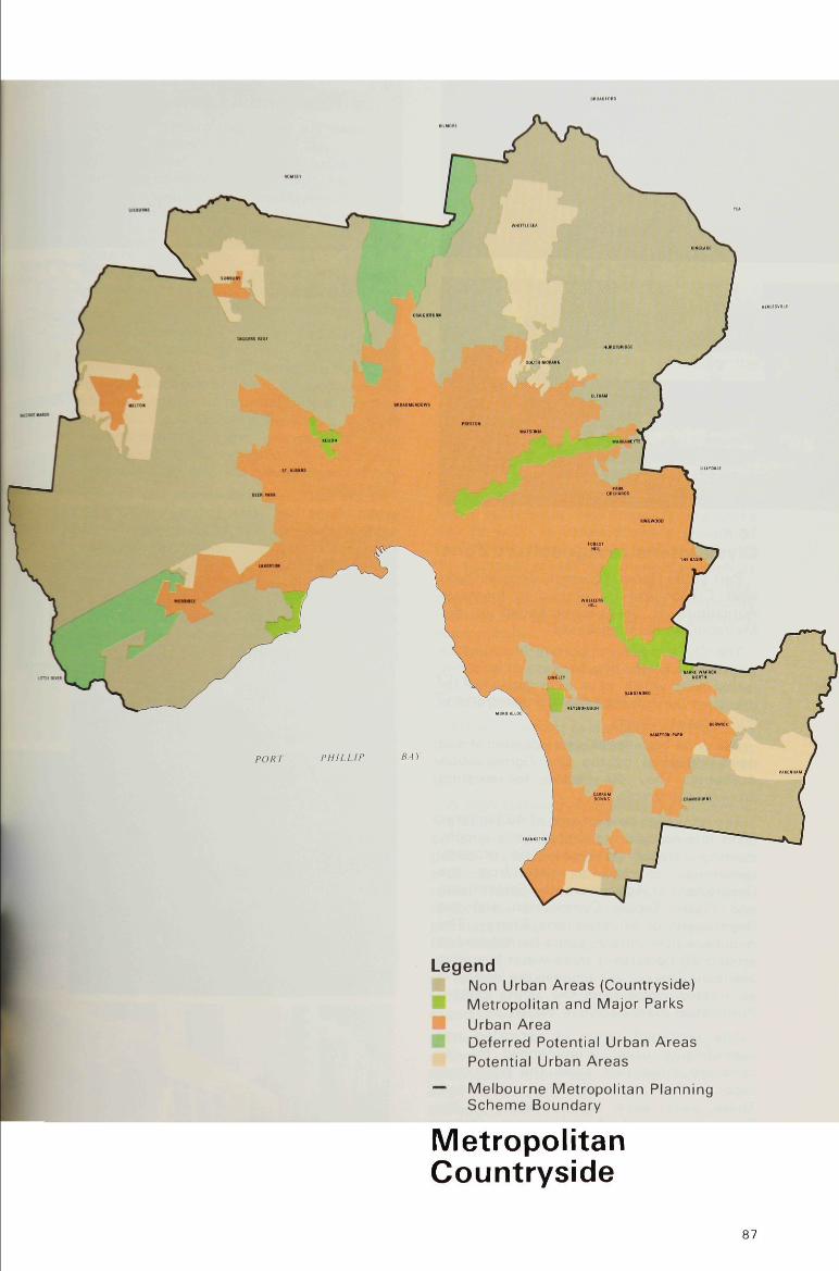
I Legend Non Urban Areas (Countryside) Metropolitan and Major Parks Urban Area Deferred Potential Urban Areas Potential Urban Areas
— Melbourne Metropolitan Planning Scheme Boundary
Metropolitan Countryside
87

16.4
Clyde Intensive Agr icul ture Zone Part of the General Farming Zone at Clyde
near Cranbourne is rezoned to Intensive Agriculture B, as recommended in the Metropolitan Farming Study.
The Clyde area is important in vegetable growing for Melbourne because of its sandy loamy soils which have high capability for intensive agriculture. Its main constraint is limited water supply.
The zone boundaries take account of soil types identified by the Soil Conservation Authority. They also allow for existing property ownership.
The minimum new lot size of 40 hectares takes into account the limited water supply, existing farming practices and property ownership, as well as data from the Department of Agriculture, the State Rivers and Water Supply Commission and the Department of Minerals and Energy. The minimum new lot size could be reduced to around 30 hectares if more water becomes available. This could happen in the long term as treated water from the South-Eastern Purification Plant becomes available.
The restricted range of permitted and discretionary uses recommended for the zone are those that allow the productive capacity of the area's soil to be maintained. These uses were agreed upon by the D e p a r t m e n t of A g r i c u l t u r e . O t h e r discretionary uses, such as additional worker housing and the excision of a house lot for a family member, are recommended.
16.5 Ryral-Residential Land
A small but significant number of people seek to live in a rural setting close to community services and facilities. The selection of rural-residential areas capable of low density residential development without provision of major works such as reticulated sewerage is under investigation.
These areas wi l l complement existing opportunities for low density living available wi th in the Residential D and Reserved Living Zones of the Metropolitan Scheme.
Suitable areas for rural-residential use wi th in corridors or urban zones adjacent to the urban fringe wi l l have a reticulated water supply, adequate drainage and soil capableof containing effluent from an approved on-site sewage treatment system. The conflicting needs of urban and rural populations and the impact of such development on agriculture and the environment wi l l also be considered.
In the past, rural-residential use in non-urban zones has often led to problems for nearby farmers. Some of the problems encountered include property infestation by vermin and noxious weeds, creation of erosion hazards and an increase in attacks on livestock by marauding domestic dogs. Many management problems have arisen from lots too large for easy handling by residents wi th gardening equipment.
(jpws* t •."W" , -
jfc'u&ditaaffliB^
l i i ^ H i TrtTJiP
~u
W^^*
i'
t"
>