method for determining relative suitability of existing...
TRANSCRIPT

state. HRB, Bull. 299, 1961, pp. 56-63. 3. E. A. Christiansen, ed. Physical Environment of
Saskatoon, Canada. National Research Council of Canada, Ottawa, 1970.
4. Soil Survey Manual. U.S. Department of Agriculture, Handbook 18, U.S. Government Printing Office, 1951, pp. 169-172.
5. D. W. Fisher, ed. Geologic Map of New York. New York state Museum and Science Service, Albany, 1970.
6. D. M. Greer and D. C. Moorhouse. EngineeringGeological studies for Sewer Projects. Journal of the Sanitary Engineering Division, Proc., ASCE, Vol. 94, No. SAl, Feb. 1968, pp. 20-24.
7. W. H. Wischmeier, C. B. Johnson, and B. V. Cross. A Soil Erodibility Nomograph for Farmland and Construction Sites. Journal of Soil and
Water Conservation, Vol. 26, No. 5, 1971, pp. 189-193.
69
8. W. H. Wischmeier and L. D. Meyer. Soil Erodibility on Construction Areas. HRB, Special Rept. 135, 1973, pp. 20-29.
9. G. W. Musgrave. How Much Rain Enters the Soil? In Water: The Yearbook of Agriculture, U.S. Department of Agriculture, 1955, pp. 151-159.
10. s. L. Chaiang. A Runoff Potential Rating for Soils. Journal of Hydrology, Vol. 13, 1971, pp. 54-62.
11. G. J. Latshaw and R. F. Thompson. Water Table study Verifies Soil Interpretations. Journal of Soil and Water Conservation, Vol. 26, No. 2, 1968, pp. 65-67.
Publication of this paper sponsored by Committee on Engineering Geology.
Method for Determining Relative Suitability of Existing Geotechnical Data for Regional Planning David Hoffman and J. Hadley Williams, Missouri Geological Survey Rolla A. Keith Turner, Geology Department, Colorado School of Mines, Golden Harry W. Smedes, U.S. Geological Survey
During regional planning studies, the engineering geologists must choose among diverse, competing data sources, each having distinct cost and accuracy characteristics. Recognizing a need for guidelines in this area, the Missouri Division of Geology and Land Survey, Rolla, Missouri, evaluated a sequence of alternative sources of data on the Cape Girardeau quadrangle in southeastern Missouri. Several map sources were compared at three scales: statewide (1 :500 000), countywide ( 1 :62 000), and quadrangle (1:24 000). Engineering and geologic considerations were used to establish criteria for 10 land uses associated with residential development. These criteria were used with the appropriate source data to develop a sequence of limitations maps at each scale. Extensive field and laboratory programs were carried out to prepare the best-possible datareference source with which other map products could be compared. A usefulness index was formulated to measure the degree of agreement between the competing interpreted products and the reference standards. Manual computation of this index proved impractical [a 10-km2 (4-mile2 )
area required 1 person day/comparison]_ Thus, computer methods were used that permitted the rapid comparison of approximately 32 000 cells covering the quadrangle and the computation of the resulting usefulness index for about $50.00 (including all salaries and data-processing costs).
The growing interest in and demand for environmental assessment has caused a reappraisal of land-use planning activities and accelerated demands for suitable engineering geology maps. The majority of these demands emphasize the need to display the natural constraints to development of various land uses. These new types of map displays, which range from rather generalized, small-scale displays covering large regions, or even entire states, to more-specific larger-scale ones covering local areas or counties, must be understandable by a variety of people.
Many traditional map forms, however, poorly satisfy these new demands, and considerable experimentation on new mapping formats has been undertaken [some of
the new techniques are reviewed elsewhere (l)]. The pressure for the development of new mapping- techniques has been felt most intensely by the state geological surveys, and several states have expanded, or even created, agencies to undertake such projects.
In Missouri, a number of environmental geology maps have been developed (2, 3), but a single map, accompanied by tables descilbTng natural conditions and constraints to development, does not always suffice. Planners frequently desire a series of interpretive maps, each showing the degree of constraint for some specified class of use. These maps, reflecting both geologic conditions and estimates of probable hazards to life and property, are used in combination with other planning factors in guiding future development.
In this paper, these interpretative land-use-limitations maps will be called limitations maps. Each such map analyzes for a single land use or for a group of closely associated uses. The development of these maps requires the setting of standards or procedures for their construction in order to maintain quality and consistency.
In the first stages of a program to develop such standards, four steps were undertaken.
1. Limitation categories were defined: Four limitations categories were selected-severe, moderate, slight, and none-to indicate the probable degree of limitation to development.
2. Standard land uses were defined: Ten land uses were chosen-sanitary landfills, road construction, foundations for light structures (i.e., houses), agricultural suitability, septic tank systems, ease of excavation, impoundments, sewage lagoons, soil erosion, and landslide potential-to represent the range of con-

70
Table 1. Example rating system: sanitary landfill activity.
Rating Constraint
No The bottonl and sides or the lru1d11ll niuBL be of a nlll.tc.i·ial such Utnt lcacbales (a) travel less Ul!Lll 30 .5 m horizontally ln 1000 days and (b) limitations never reach the groundwnle i· table (unless the leacha te will cause no decrease in qua:lity of the hlghest-qunilty groundwater body that has
historically existed within a 16-km radius) There must be sufficient soil at the site for a 15.2-cm daily cover There must be sufficient soil at the site for a final cover 0.9 m deep The final cover should be equal to or less permeable than the bottom and sides of the landfill The landfill site must never be subject to flooding The site must nnt be RllRr.P.ptihlP. to collapse, for example, collapse induced by saturation, inundation, or high transmission rates of
leachates The landfill must be located at least 1.5 km from the nearest water well or spring that produces 378 L/min and at least 0.75 km from all
other water wells or springs There must be a minimum ol 3 m of material between the bottom of the landfill and the normal wet-season piezometric surface
Slight Tho bottom and sides ol the landfill must be of a material such lllfll lenchntes (a) travel less th."1.11 30.5 m horizontally in 1000 days and (b) limitations never reach the groundwnter table (unless the leachate will causu no decrease in qultlity of Ute highest-quality groundwater body that has
historically existed within a 16-km radius) There must be sufficient soil at the side for a 15.2-cm daily cover There must be a sufficient supply of soil located less than 1.6 road-km from the landfill to provide a final cover 0.9 m deep The final cover should be equal to or less permeable than the bottom and sides ol the landfill The landfil l s ite may be SlJbjecl to lloodlng by a .100-yeu Uood (U·.s . Wntor Resource.; Cowicll, 1967) The site must not be susc !)tllJle to colmpse, for xample, colla1ise induced by saturation, Inundation, or high tranamlssion rates o! leachates The lnnd!UI must be located . t least l.5 km U:om lhc nearest water well or sprln" lhai produces 378 L/ min and at lea.st 0.75 km from all
other water wells or springs There must be a minimum of 3 m of material between the bottom of the landfill and foe normal wet-season piezometric surface
Moderate The bottom and sides ol the landfill must be of a material such that leachates (a) travel less than 61 m horizontally in 1000 days and (b) will limitations not reach the groundwater table in less than 1000 days (unless the leachate will cause no decrease in the quality of the highest-quality
groundwater body that has historically existed within a 16 -km radius• There must be sufficient soil at the site for a 15.2-cm daily cover There must be a sufficient supply of soil located less than 4.8 road-km from the landfill to provide a final cover 0.9 m deep The final cover should be equal to or less permeable than the bottom and sides of the landfill' The lnnd£l ll s ite may bn subject to tloodlng by a 2&-ye:u· Doud (U. S. \V;1tor Reaources Council, 1967) The site mur;L not be !lusceptlbltl to cotlaµsu . Co1· C.'<llmplc, colln(lSC Induced by salUL"nilon, inundaUon, or high transmission rntes of leachates The l111ulllll must lie localed a l least L.5 km from lhe nc:u·cal water well or spring producln~ 378 L/min and at least U.'15 km from all other
water wells or springs There must be a minimum of 0.9 m of material between the bottom of the landfill and the normal wet-season piezometric surface'
Severe limitations All other areas
Notes: 1 m = 3,28 ft; 1 km= 0.62 mile; 1 L = 0 264 gal , Landfills are rated primarily on surface material and susceptibility to surface and/or groundwater pollution unless corrective measures are taken ,
• 1r a site in this area is to be used, thi s condition must be upgraded by appropriate engineering, to the value(s) given for ''no limitations".
cerns related to residential developments. 3. An objective rating system was developed: A
standard, objective rating system was developed for each land use to allow the translation of geologic conditions into constraints; an example rating system is shown in Table 1.
4. Data sources and scales were identified: A variety of data sources-federal, state, local, and private-and scales were identified for many types of data, and three distinct mapping scales were identifiedstatewide at a 1: 500 000 scale, countywide at a scale of about 1 :62 500, and local and quadrangle at scales of 1 :24 000 or larger.
The engineering geologists were thus faced with the problem of reconciling and recompiling existing information available at a variety of scales and accuracies. Each data source had some distinctive, but generally unknown, cost and accuracy characteristics. Obviously the moreexpensive data sources are generally more detailed and hence more precise and therefore should yield morear.r.urate interpretive limitations maps. On the other hand, in the face of budgetary constraints, use of the mos t expensive data is not always the best solution. For example, if two competing data sources are such that the cost of one is only 2 5 percent of the cost of the other, but the interpretive results of the first are at least 80 percent as accurate as those of the second, should the cheaper source be used?
In an attempt to answer such questions, a few interpretive limitations maps were produced by using competing data sources. These maps showed similar, but not identical, patterns of limitations. A more-precise method of evaluating the quality of competing data sources was needed and, accordingly, a research task was de-
fined to establish such a method. This paper descr ibes the results of that task.
THEORETICAL BASIS AND METHODOLOGY
The comparison of two or more maps is a common geological and geographical problem. Although qua ntitative comparisons seem potentially useful to geologists , only a few attempts have been made to produce such values. Fortunately, geographers have studied this problem for s everal year s and have developed a number of techniques (4, 5). None of the existing m ethods could precisely solve the needs of this study, however, · and a modified procedure was developed based on cross-correlation concepts (!).
Limitations Categories and Limitations Units
As shown in Figure 1, by combining any two of the four standard limitations categories, a new distinctive limitations unit can be produced. By using all pui:;i:;lLle combinations, 10 dis tinctive limitations units can be shown on each map. The i·ange of each limitation unit is defined by a n upper (01· ceiling) limitation that reflects t.he most-restrictive category and a lowe1· (or floor) limitation that reflects the least-restrictive category.
In cases of perfect agreement between the limitations units on two maps, it is easy to see that the two maps are in perfect agreement. Similarly, in thos e cases where two map units totally disagree (a severe limitations unit on map A corresponding to a moderate limitations unit on map B, for example ), it is easy to recognize perfect disagreement. Such situations are rare,

I I I
I
Figure 1. Derivation of 10 distinctive limitations units from four main limitations categories.
LIMITATIONS UNITS
1 2 3 5 6 8 9 10
"' "' "' E-< "' g; "'
< E-<
"' "' "' "' ~ "' "' "' c: "'
A
"' "' 0 0
"' "' "' ::; ;> 0 E-< E-< "' "' ;;; < ~ ' "' "' "' E-< E-< "' ' c: "' "' "' § :t: "' "' g; 0 0 "' "' z z
"' 0 ~ ::1 :::; ::1 0 0
"' ;;; "' "' "' z z
"'"' SEVERE
z"' o- MODERATE - "' ~8 SLIGHT t: ~
~< NONE ...:i u
Figure 2. Two maps that have overlapping limitation units : example.
MAP A MllP B
Sv Sv N-SI
SI
E-<
"' CJ ::l "' "' z 0 z
Sl-Sv 0
M
"' 6 z
however; most commonly, the limitations units on one map (map A) will partially, but not completely, correspond with the limitations units on U1e second map (map SL Because the limitations units are defined in terms of the four original limitations categories, the possibility of partial overlaps in their r anges is high. The ~umber of possible partial overlaps ranges from one to iour.
Figure 2 shows two theoretical limitations maps. At Point Z, map B has the limitation unit "slight-to-severe" ~nd map A has the limitation unit "moderate". Because l'lloderate is not identical to slight-to-seve1·e, it can 'be argued that the two maps do not correlate. On the other hand, one could a.rgue that, because moderate is included within the range slight-to-severe, the correlati<ln is perfect! Neither of these arguments gives a true representation of the relative similarity of the two maps.
What is required is a met.hOd of computing a quantitative degree of correlation between the two maps that t~es into account the degree of similarity (or overlay) anct the ranges of the two map units. This can be done bY the following procedure:
l. Define the concept of an agreement number (a), ~. Compute a usefulness number (U.) based on the
ag1·~ement number, and a. Compute a usefulness index (m) by summing the
usefulness numbe1·s, weighted according to s ubareas, 0 ver- the entire area of interest (wl1ich may be the entfre lllapJ.
Thu~, the usefulness index is a single value for the entire iarea of interest, while the other values ru:e essentiailY> po int values associated with unit areas.
71
Agreement Number
The agreement nwnber measures the degree of commonality between two limitations units. It is defined as one more than the number of nonoverlapping limitations catego1·ies (n) occurring in the two limitations units being compared (i.e., a = n + 1).
Thus, if two limitations units match perfectly, there are no nonoverlapping limitations categories; therefore, n = O and a = 1. Where no commonality exists, the agreement nwnber is defined as zero (a = o). By referring to Figure 1, it can be seen that, provided some commonality exists, n is between 1 and 3 and, thus, the agreement munber is between 0 and 4.
Usefulness Nwnber
The usefulness number converts the agreement number to a measure of usefulness of the two data sources . Where there is perfect agreement between the limitations units on the two maps (a = 1), both maps are totally useful predictors of the limitations. Where there is total disagreement between the two maps (a = O), the maps are useless as predictors.
The usefulness nwnber should range from 0 (useless) to 1 (totally useful)· the distribution between these limits may be linear, geometric, or logarithmic. A geometric distribution was chosen, and usefulness number was calculated by using Equation 1.
U3 = O (a= 0)
U, = [ I / 2<•-!J] (a ;;. I) (!)
The relationships among the degree of overlap (commonality), number of nonagreeing limitations (n), agreeme11t number (a), and usefulness number (U.) are summarized below.
Degree of Overlap _r:: a u. -
None Not applicable 0 0.0 Perfect 0 1 1.000 Some 1 2 0.500 Some 2 3 0.250 Some 3 4 0.125
Usefulness Index
The usefulness number can be used to compute a single usefulness index that expresses the degree of commonality of one area, region, or map with another. The usefulness ind.ex (UI) is the weighted sum of the areas belonging to each level of agreement and can be calculated by using Equation 2.
I
Ul = 10 L A. U,/A, (2) a=o
where
A. =map area(s) belonging to agreement number a, At "' total mapped area, and
1 =maximum agreement nw11ber = numbe1· of limitation categories.
The usefulness index will be between 0 and 10· the higher the index number, the better the agreement between the two maps.
As defined, the usefulness index can be used to compare two maps only. Where it is necessary to compare th1·ee or more maps, one map should be chosen as a

72
Figure 3. Landfill limitat.ions map: Section 23 (T 31 N, R 13 El. Cape Girardeau quadrangle-(a) reference standard map (compiled from all 1 :24 000 scale data) and (bl compiled from 1 :62 500 scale geologic map and enlarged to 1:24 000.
A B
!lllTilTIITIJITfTITITI~~
[]Sv OM-Sv •s1-sv §N-Sv ~N
Figure 4. Landfill-limitations comparison map: Section 23 (T 31 N, R 13 El, Cape Girardeau quadrangle.
Numbers represent agre~111e1-1t n~mber for ttrea .
base, and all the other maps should be compared with it.
TEST OF THE CONCEPT IN THE CAP • GIRARDEAU AREA
The concept was tested in the Cape Girardeau quad.l'angle of southeastern Missou1·l, located on the west bank of the Mississippi River about 50 km north of Cairo, Illinois, and 140 km south of St. Louis. This quadrangle includes some of the Mississippi Rive1· floodplain and the adjacent uplands, which are typical of the nonglaciated, midcontinent sedimentary terrains. The following procedure ~used.
l. Data sources we1·e identified: Data Wtlrecollcc;ted from maps at three scales-statewide (1:500 000), countywide (1:62 500 approximately), and quadrangle (1:24 ooo>.
2. Field and laboratory investigations were made: Extensive Held and laboratory programs were undertaken to confirm the accuracy of the data and to deter mine the most-accurate source. Costs of all datacollectio11 efforts were carefully monitored.
3. Sow·ce maps were converted to limitations maps: By using the existing standardized objective-rating system, a sequence of maps showing the limitations for each of the 10 standard land uses was developed. Limitations maps were constructed for land use that i·eilected the data available at 1:500 000, 1:62 500, and 1:24 000 scales.
4. Reference standai·d maps were defi11ed: The limitations maps for each land use at the 1 :24 000 scale were based on the best, most-detailed data, and were therefore designated the reference standard maps for each land use.
5. The various limitations maps were compared with the i·eference standard maps: Comparison of the limitations maps at the 1:500 000 and 1:62 500 scales with the appropriate standard reference map at the 1 :24 000 scale indicated the relative usefulness of more-detailed data versus more-generalized data.
The final step was critical to the successful conclusion of the task. The comparison between the derived usefulness indices for each land use .and the data-collection costs provided a rational basis for the selection of the best source of data for each land use.
The fallowing example illustrates the steps used in computing the usefulness index. A 10-km2 (4-mile2
)
area [Sections 23( 24, 25, and 26, township (T) 31 north (N), range R) 13 east (E)) was selected as a typical test site. A landfill constraints map p1·oduced from bedrock geologic data at a scale of 1:62 500 (see Figm·e 3a) was compared with a landfill limitations map (the landfill refer nee standard map) produced from all available data at a 1 :24 000 scale ( ee Figure 3b). The two maps were then ov rlaid, and the bOundaries of the areas having each agreement nwnber were outlined and the agreement numbers labeled (see Figw·e 4). .Finally, all these areas were planimetered and recorded, and the usefulness index was calculated as shown below.
a A,s (arbitrary units) A,
0 102, 48, 1 151 1 15, 19, 712, 5, 16, 85, 8, 6, 167, 11 1044 2 4, 9, 6, 21, 23, 54, 71, 19 207 3 102, 4, 16, 89, 75, 11, 23 320 4 1068 1068
Therefore,
Z:At = 2790
a Quantity 0 2 3 4
A, /A, 0.054 0.374 0.074 0.115 0.383 u, 0.0 1.000 0.500 0.250 0.125 (A,/A,)U, 0.0 0.374 0.037 0.029 0.048
and
UI = 10(0.0 + 0.374 + 0.037 + 0.029 + 0.048) = 4.88:. 5
COMPUTER-ASSISTED CALCULATIONS
The manual calculation method described above required considerable effort to draft each map, develop the overlaid map comparison, determine the degrees of overlap for each a.rea, planimeter each area to determine its extent, and pel'form the calculations . By the time that the usefulness indices for three small areas (each about 10 km 2
) had been alculated manually for two different land uses, it was appai·ent that the method was not cost effective . On the average, it appeared to take about one person day to compute the usefulness index for one land use for 10 km 3
•
The evaluation of the procedure really needed a much larger nwnber of comparisons completed. Also, the usefulness indices should be calculated over the entire map not just for three small test areas. Although the test sites had been selected to be representative of the dominant conditions within the map area, some uncer-
73
Table 2. Computer-calculated usefulness indices: comparison of reference standard maps and data source maps.
Usefulness Index
Data Source Map Map Scale Landfills Roads Foundations
Rock 1:500 000 5 L 1 1:62 500 4 l 2
Soils 1:750 000 4 3 5 1:63 300 5 3 5
Engineering bedrock 1:24 000 2 Suriicial geology 1:24 000 2 10 10 Groundwater 1:24 000 4 Flooding potential L:24 000 1 Surficial unit per-
meability L:24 000 Time of travel 1:24 000 strength 1:24 000 5 10 Slope l:24 000
Table 3. Comparison of usefulness indices for landfills and roads computed manually and by computer.
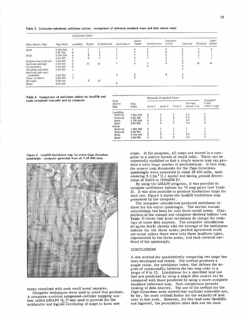
Figure 5. Landfill limitations map for entire Cape Girardeau quadrangle : computer generated from all 1 :24 000 data.
Agriculture
5 5 1 2
7
3
Data Source Map
Landfills Bedrock Bedrock Soils Soils
Roads Bedrock Bedrock Soils Soils
tainty remained with such small areal samples. Computer techniques were used to solve this problem.
A computer-assisted component-cellular mapping system called GMAPS (6, 7) was used to pr ovide fo1· the arithmetic and logical overlaying of maps to form new
Septic Impound- Land-Tanks Excavations ments Lagoons Erosion slides
4 4 6 0 6 4 5 0 5 2 3 1 5 3 3 1 1 5 2 9 7 8 2 10 10
6 4 2
9 6 3
Manually Computed Value Computer
Map Average Value Scale Area 1 Area 2 Area 3 (areas 1-3) (entire map)
1:500 000 a 6 2 3.7 5 1:62 500 5 4 4 4.3 4 1:750 000 4 5 3 4.0 4 1:63 360 5 5 5.0 4
1:500 000 1 1 1 1 1:62 500 1 1 1 1 1:750 000 2 3 5 3.3 1:63 360 2 2 3 2.3
maps. In the program, all maps are stored in a computer in a matrix format of small cells. These can be repeatedly modified so that a single source map can produce a very large number of permutations. In this step, the source map documents for the Cape Girardeau quadrangle were conver ted to about 32 000 cells, each covering 2.5 hma (1.1 ac1·es) and hav ing ground dimens ions of 6lx76 m (200x250 it).
By us ing the GMAPS program, it was pos sible to compute usefulness indices for 70 map pairs (see Table 2), It was also possible to produce limitations maps for each use; Figure 5 shows the landfill limitations map generated by the computer.
The computer calculations produced usefulness indices for the entire quadrangle. The earlier manual calculations had been for only three small areas . Comparison of the ma nual and computer -der ived indices (see Table 3) shows that local variations do change the rankings of some data sources. The computer calculations do agree fairly closely with the average of the usefulness indices for the three areas; perfect agreement could not occur unless there were only three landform types, represented by the three areas , and each covered onethird of the quadrangle.
CONCLUSIONS
A new method for quantitatively comparing two maps has been developed and tested . The method produces a single value, the usefulness index, that defines the degree of commonality between the two map units in a range of 0 to 10. Limitations for a specified land use that are predicted by using a single data source can be compared with those predicted by using a more-complete standard reference map. Such comparison permits ranking of data sources. The use of the method for the Cape Girardeau area showed that surficial materials are, by far, the most critical factor for the majority of land uses in that area. However , for two land uses (landfills and lagoons), the percolation rates data are the most
74
important. Such information should prove useful in planning future field studies.
Except for very limited test areas, manual calculation of the usefulness index is impractical. Computerbased techniques are feasible, however. These can compute a s ingle usefulness index for a quadrangle for about $ 50.00 (including data entry, processing , and display cos ts , for both salaries and computer t ime). Most of the data entry and checking can be carried out by technicians. Although, in this study, the computation of the indices was performed by senior staff, this is not necessary because the process can be documented and followed in a routine manner by technicians.
ACKNOWLEDGMENT
The program to establish the mapping standards was undertaken jointly by the Missouri Department of Natural Resources, Rolla, the Resource and Land Information program of the U.S. Department of the Interior, and the Colorado School of Mines, Golden.
REFERENCES
1. D. J. ·varncs. The Logic of Geologic !v!aps, ·with Reference to Their Interpretation and Use for Engi-
neering Purposes. U.S. Geological Survey, Department of the Interior, Professional Paper 837, 1974, 48 pp.
2. E. E. Lutzen and J. D. Rockaway. Engineering Geology of St. Louis County, Missouri. Missouri Geological Survey, Engineering Geology Series 3, 1971.
3. J. D. Rockaway and E. E. Lutzen. Engineering Geology of the Creve Coeur Quadrangle, St. Louis County, Missouri. Missouri Geological Survey, Engineering Geology Series 2, 1970.
4. J. C. Davis. Statistics and Data Analysis in Geology. Wiley, New York, 1973, 550 pp.
5. J. C. Davis and M. J. McCullagh. Display and Analysis of Spatial Data. Wiley, New York, 1975, 378 pp.
6. A. K. Turner. Computer-Aided Environmental Impact Analysis: Part 1-Procedures. Mineral Industries Bull. (Colorado School of Mines, Golden), March 1976, Vol. 19, No. 2, 23 pp.
7. A. K. Turner. Computer-Aided Environmental Impact Analysis: Part 2-Applications. Minerals Industries Bull. (Colorado School of Mines, Golden), May 1976, Vol. 19, No. 3, 16 pp.
Publication of this paper sponsored by Committee on Engineering Geology.
Computerized Information System for Indiana Soils G. D. Goldberg, Woodward-Clyde Consultants, Clifton, New Jersey C, W, Lovell and Robert D. Miles, School of Civil Engineering, Purdue
University, West Lafayette, Indiana
A comprehensive information storage system for Indiana soils is being operated on a computer at Purdue University, West Lafayette, Indiana, and at the Division of Materials and Tests of the Indiana State Highway Commission. Information is being collected that includes geotechnical, pedological, and geological data from records of subsurface investigations obtained during the period 1950-1978. Test data from more than 2500 soil sample.shave been stored and, within the year (1978), it is anticipated that date for an additional 6000 soil samples will be recorded. The data have been evaluated by various statistical methods. Results indicate that the range in values to be expected for a given soil parameter depends on the particular physical property and on the population from which the soil has been sampled. Some soil properties appear to be inherently more variable than others. To illustrate applicability, correlations have been made by using the information relative to physiographic unit and parent material. The grouping of soils by physio11raphic regions or origin of parent material (or both) suggests that the predictability of some parameters can be improved for certain combinations of parnm·eters and soil groups. Specifically, prediction equations were generated for compression in-dex, compressio.n ratio, and unconfined compressive strength for cer-tain soil populations. It is also possible to predict compaction test values, standard American Association of State Highway and Transportation Officials maximum dry and wet densities, and optimum moisture contents for selected physiographic and parent-material groupings.
The accumulation of laboratory and field-test data for characterizing the engineering properties of Indiana soils is extensive. An enormous amount of data, collected and stored from highway projects during the period 1950-1978, have been retained in the form of
subsurface investigation reports. These reports were prepared by private consulting firms and governmental agencies from routine soil investigations. In their bulky, voluminous form, the majority of these data are not particularly useful for planning and engineering studies.
The need exists to make this information more accessible to both the engineer interested in detailed information about a site and the engineer interested in general soil characteristics over a large area. A computerized geotechnical data bank was judged to be the most efficient, expedient, and economical way to reduce the accumulated data to a form that could readily be made available to interested individuals.
This paper describes the development of a comprehensive information-storage system for soils data. Geological, pedological, and geotechnical engineering information are being collected and stored in a computerized system. Test data from 2508 soil samples have been stored in conjunction with developing and testing the computer system and, in addition, approximately 5500 other data sets have been stored (for a total of more than 8000 soil test samples).
Various statistical methods have been applied to some of the data. Results indicate that the range in values to be expected for a given soil parameter depends on the particular physical property and on the population from which the soil was sampled. The grouping of