met office science review meetings 2012 · • preliminary study consisting of ~12 start dates...
TRANSCRIPT
© Crown copyright Met Office
Modelling and prediction across timescales Tim Johns, Adam Scaife, Doug Smith, Malcolm Roberts MOSAC/SRG, 14-16 November 2012
Met Office Science Review Meetings 2012 MOSAC 17.10
SRG 9.10
© Crown copyright Met Office
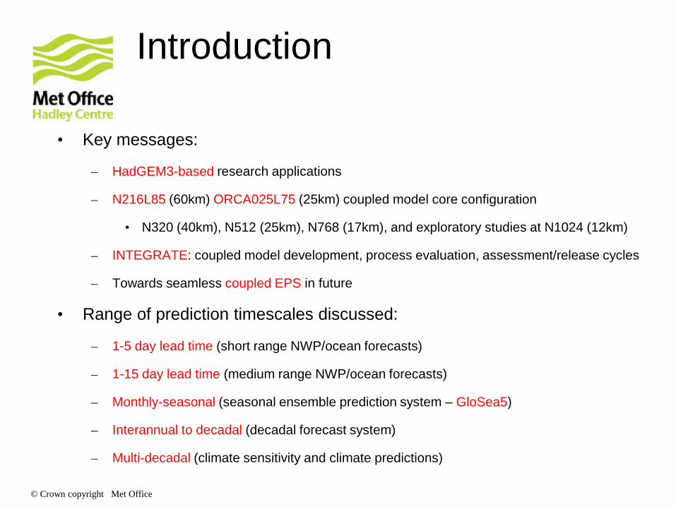
Introduction
• Key messages:
– HadGEM3-based research applications
– N216L85 (60km) ORCA025L75 (25km) coupled model core configuration
• N320 (40km), N512 (25km), N768 (17km), and exploratory studies at N1024 (12km)
– INTEGRATE: coupled model development, process evaluation, assessment/release cycles
– Towards seamless coupled EPS in future
• Range of prediction timescales discussed:
– 1-5 day lead time (short range NWP/ocean forecasts)
– 1-15 day lead time (medium range NWP/ocean forecasts)
– Monthly-seasonal (seasonal ensemble prediction system – GloSea5)
– Interannual to decadal (decadal forecast system)
– Multi-decadal (climate sensitivity and climate predictions)
© Crown copyright Met Office
Modelling and prediction across timescales – Coupled NWP research Tim Johns, Ann Shelly, GCMP and SRCFD teams (Met Office) Acknowledgement: Nick Klingaman (University of Reading) MOSAC/SRG, 14-16 November 2012

© Crown copyright Met Office
Coupled NWP R&D in the Met Office
• Four working groups were set up ~2 years ago, to take forward Met Office specific actions in response to recommendations from an International Workshop on Upper Ocean-Atmosphere Interactions on Weather and Climate Timescales held at the Met Office in Dec 2009:
http://www.ncof.co.uk/Ocean-Atmosphere-Workshop-Dec-2009.html
• The coupled NWP initiative was taken forward over the past 2 years by a Working Group on Ocean-Atmosphere Coupling and Interactions on NWP timescales, which was set up to provide a focus for delivering initial phases of the underpinning R&D (but this WG is now disbanded)
• The work now continues under business-as-usual arrangements, resourced primarily by the Global Coupled Model Development and Processes team in Global Model Evaluation and Development (Foundation Science) in concert with Short-Range Coupled Forecast Development team in Ocean Forecasting R&D (Weather Science)

© Crown copyright Met Office
Motivation for coupled NWP R&D
1. To explore the role of air-sea coupling in potentially providing improved forecast skill (focusing on the 1-15 day timescale) – for both atmosphere and ocean/sea ice forecasting purposes
2. To probe systematic model errors and drifts that are robust across forecast timescales – to enhance understanding of errors and error-compensations with the aim of tackling process errors ‘at source’
3. To deliver an efficient platform for undertaking global coupled model evaluation and R&D feeding into future model releases and systems
→ Met Office future operational system drivers: • Coupled medium-range NWP system (MOGREPS/GloSea merger) • Coupled global short-range ocean forecasting system (MyOcean2) • High resolution global coupled ensemble NWP system (2020 vision)
→ Also aligns with the seamless prediction/model assessment agenda: more unified scientific formulation and experimental setups using global coupled models across timescales from days to decades (INTEGRATE project)

© Crown copyright Met Office
Recent progress
• FY2010-11 (Phase 1 study) • Preliminary study consisting of ~12 start dates using a previous
development version of HadGEM3-AO → Met Office PWS report 1
• FY2011-12 (Phase 2 study → focus for this talk) • Extensive set of case studies updated to HadGEM3-AO at
GlobalAtmos3 (GA3), with better ocean/ice/rivers initialisation, and start dates chosen for synergy with other projects → Met Office PWS report 2
PWS deliverable reports (available from the Met Office):
1. Shelly et al. 2011: “Preliminary case-study experiments with a global ocean-atmosphere coupled model configuration on 1-15 day timescale”
2. Johns et al. 2012: “Report on extensive coupled ocean-atmosphere trials on NWP (1-15 day) timescales”

© Crown copyright Met Office
Phase 2 model & experiments
Coupled model
HadGEM3-AO N216L85 (GA3.0) + ORCA025L75 (NEMO3.2) + CICE (4.1) + OASIS coupler
Experiments
• ~130 coupled case studies to T+15 days, with 3-hourly coupling frequency
• Atmosphere-only and ocean-only control forecasts run for subsets of the coupled cases
• Selected start dates in the range June 2008 to November 2010
• Core set of 10 “winter” and 10 “summer” cases, plus MJO periods and other cases
Initialisation and boundary conditions • Coupled: free running (no flux adjustment/bias correction) starting from:
• Met Office operational NWP analysis at 12z (interpolated to N216L85) [Atmos/Land] • 12-hour ocean forecast, from analysed state at 0z to 12z, using the latest FOAM-NEMOVAR
model (ORCA025L75/NEMO3.2 + CICE) driven with operational NWP fluxes [Ocean/Ice] • Atmosphere-only controls: Persisted initial SST anomaly (wrt. GISST), sea ice fixed
• Ocean-only controls: Driven with 3-hourly mean fluxes output from atmos-only controls 2008 | 2009 | 2010

© Crown copyright Met Office
Ongoing work – FY2012-13 to FY2013-14
• Application of coupled NWP case studies to assessment of GA4 (done), and ENDGame (GA5) in coupled mode, alongside other tests
• Development of higher resolution coupled system (in progress) • Operational NWP and ocean forecast resolutions being used: N512 (c. 25km)
atmosphere and ORCA025 (c. 25km) ocean • Case studies and assessment to commence early next year • Initial case studies will use operational atmosphere and ocean initial states
• Delivery of global coupled forecasts to MyOcean 2 by April 2014 • Initially to use 0-5 day forecasts from new GloSea5 seasonal system • N216 (c. 60km) atmosphere coupled to ORCA025 (c. 25km) ocean • Initial assessment underway
• Improved infrastructure allowing coupled NWP case study techniques to be applied efficiently in model development/assessment cycles (INTEGRATE)
• Regional UKV coupled system (UKV 4km – 1.5km resolution atmosphere coupled to a 4km shelf seas) being developed - aiming for case studies in mid-2013
• Add wave coupling and coupled data assimilation for model initialization (global and regional coupled applications)

© Crown copyright Met Office
Ongoing collaborations
• Vertical Structure and Diabatic Processes of the MJO - MJO Task force – Nick Klingaman and Prince Xavier
• Evaluation of the Indian Monsoon – Ashis Mitra, NCMRWF
• Performance of the coupled model during DYNAMO field campaign in comparison with operational models – Chidong Zhang, U. of Miami
• Tropical Warm Pool Diurnal Variability Project (TWP+) - Use in-situ data from TWP+ and compare model results against satellite data to allow assessment of the diurnal cycle over a large area – Helen Beggs, BoM
© Crown copyright Met Office
Coupled NWP case study experiments – results Verification Seamless model assessment Phenomena

© Crown copyright Met Office
Tropics 500hPa Height DJF 925hPa T JJA
RMSE
BIAS
T+ 1 5 10 15 T+ 1 5 10 15
•Two examples of good coupled skill relative to atmosphere-only control forecasts •Tropics is the main area of atmospheric performance difference
•Performance mostly comparable in the extra-tropics

© Crown copyright Met Office
850hPa T JJA MSLP DJF Geopot. Height @ T+120 JJA
Comparison with operational global model in the Tropics
BIAS
RMSE
0.0
-0.3
-0.6
0.0
-0.3
-0.6
[hPa]
0
600
1000
T+ 1 2 3 4 5 T+ 1 2 3 4 5
0
600
1000
© Crown copyright Met Office
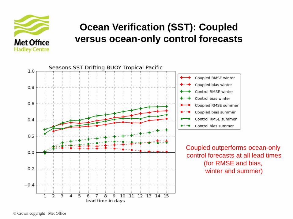
Ocean Verification (SST): Coupled versus ocean-only control forecasts
Coupled outperforms ocean-only control forecasts at all lead times
(for RMSE and bias, winter and summer)
© Crown copyright Met Office
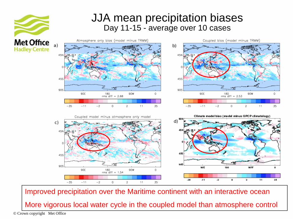
JJA mean precipitation biases Day 11-15 - average over 10 cases
Improved precipitation over the Maritime continent with an interactive ocean
More vigorous local water cycle in the coupled model than atmosphere control

© Crown copyright Met Office
SST biases: Climate vs. Coupled NWP NH. Winter NH. Summer Climate:
50-yr mean
Coupled NWP: 10 cases Day 7 Day 1 Day 14
© Crown copyright Met Office
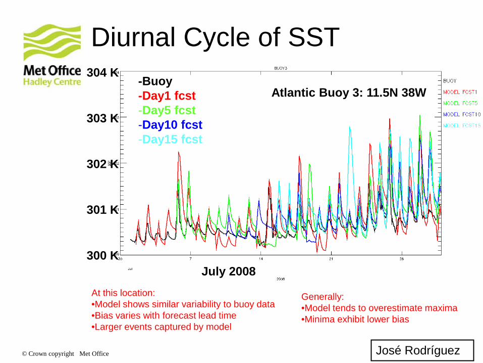
Diurnal Cycle of SST
Atlantic Buoy 3: 11.5N 38W -Buoy -Day1 fcst -Day5 fcst -Day10 fcst -Day15 fcst
At this location: •Model shows similar variability to buoy data •Bias varies with forecast lead time •Larger events captured by model
José Rodríguez
July 2008
304 K
303 K
302 K
301 K
300 K
Generally: •Model tends to overestimate maxima •Minima exhibit lower bias

© Crown copyright Met Office
Diurnal range of SST (K) Coupled Model
(Note that the HadGEM3 colour scale covers twice the range of HadDTR)
HadDTR (Kennedy et al. 2007)
© Crown copyright Met Office
Oct 20
Oct 21
Oct 22
Oct 23
....……
……….
………
Jan 15
Jan 16
Day 1 Day 2 … Day 15 Fcst Fcst Fcst
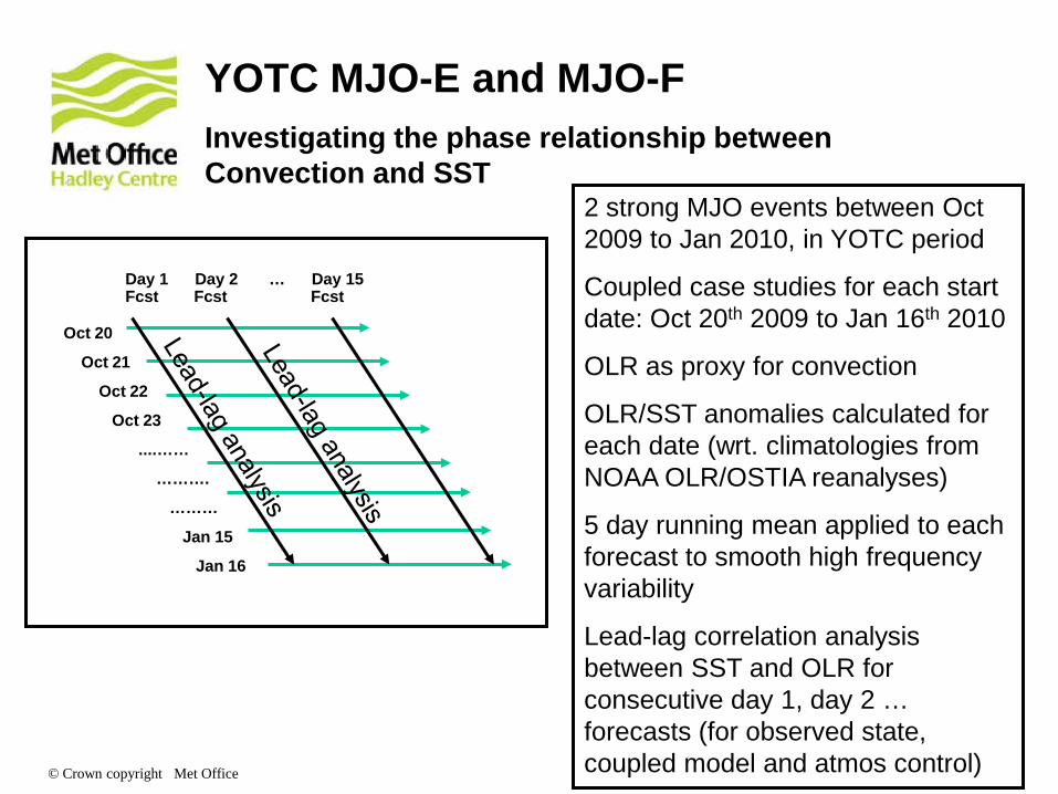
YOTC MJO-E and MJO-F Investigating the phase relationship between Convection and SST
2 strong MJO events between Oct 2009 to Jan 2010, in YOTC period
Coupled case studies for each start date: Oct 20th 2009 to Jan 16th 2010
OLR as proxy for convection
OLR/SST anomalies calculated for each date (wrt. climatologies from NOAA OLR/OSTIA reanalyses)
5 day running mean applied to each forecast to smooth high frequency variability
Lead-lag correlation analysis between SST and OLR for consecutive day 1, day 2 … forecasts (for observed state, coupled model and atmos control)

© Crown copyright Met Office
OLR/SST phase relationship : Indian Ocean Coupled model Atmosphere control Observed state
Warm SST’s lead enhanced convection by ~5-10days
MJO related fluxes have no influence on SST so convection adjusts to a location where SST is favourable Results in an in-phase relationship Coupled model maintains phase lagged relationship
Day 1 Day 2 Day 4 Day 5

© Crown copyright Met Office
MJO performance – correlation analysis
Bi-variate correlation for
forecast and YOTC analysis:
20091015 - 20091205
(a) OLR
(a) U850
Coupled
model
Atm. control
Atm. Control: YOTC initialisation
•Coupled model demonstrates most skilful OLR performance but is less skilful for winds.
•Need to determine impact of using different ‘truth’ on correlation scores Nick Klingaman, U. Reading
Persistence

© Crown copyright Met Office
Central pressure (<990hPa) captured by day 3 in coupled model forecast
but atmosphere control has shallower depression.
Additional skill comes from interactive ocean – see cooling in BoB in
evolution of the SST (day 3-day 1: colour shading)
Analysis
Coupled Model
Atmos Control
Synoptic Case Study: Bay Of Bengal Tropical Monsoon depression August 2008 – Day 3 Forecasts
992 990
990

© Crown copyright Met Office
FOAM analysis
Day 3 minus day 1 sub surface temperature at 88E
Coupled model
Day 3 minus day 1 sub-surface temperature at 88E
Shows skill in capturing mixed layer temperature evolution out to day 3.
N S
50m
150m
250m
50m
150m
250m
Synoptic Case Study: Bay Of Bengal Tropical Monsoon depression Ocean Temperature section along 88E

© Crown copyright Met Office
Summary
Air-sea-ice coupling shows promise for improving short to medium range forecasting skill, even without SST bias correction
Coupled NWP case study hindcasts are competitive with atmosphere-only control forecasts in mean bias and RMSE skill in the extra-tropics, and show improvements in skill in the tropics in both the atmosphere and ocean components
Such case studies are a useful tool in seamless model assessment – in part because they are computationally fast to run (each HadGEM3-AO case study runs in ~2 hrs on IBM P7 on 9 nodes)
Plan further analysis of coupled NWP cases study results, and development of diagnostics/metrics to assess model performance and investigate robust signals of coupled model systematic errors that emerge on short timescales (→ papers)

Modelling and prediction across timescales – Monthly to Seasonal development Adam Scaife, Alberto Arribas MOSAC/SRG, 14-16 November 2012 © Crown copyright Met Office

Why monthly to seasonal prediction?
Climate varies a lot and this can greatly amplify or oppose any trend: Tropical Floods during 2010/11 Russian heatwave 2010 Recent Cold European and US winters
Temperature
Time (years)
Climate Change
Climate Change + Variability
Barcelona, Spain, March 2010 Dry Water Pan, Kenya, 2011

How can we make progress?
Initial
Conditions
Forecast
System
Boundary
Conditions
Model
Ensembles
Obs Analysis
GHGs Aerosol
Hcast Solar
Model 1
Model 2
Model 3
One approach is model perturbations but we need model improvements: long timescale modes & processes, teleconnections and response to external forcing
ENSO predictions from UKMO, ECMWF & MeteoFr
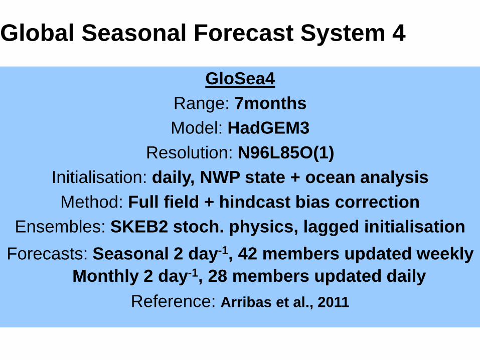
Global Seasonal Forecast System 4
GloSea4 Range: 7months Model: HadGEM3
Resolution: N96L85O(1) Initialisation: daily, NWP state + ocean analysis Method: Full field + hindcast bias correction
Ensembles: SKEB2 stoch. physics, lagged initialisation Forecasts: Seasonal 2 day-1, 42 members updated weekly
Monthly 2 day-1, 28 members updated daily Reference: Arribas et al., 2011

Seasonal Hindcasts: different strategies around the world
Hindcast length
Frequency of system upgrades
Centre's priorities
JMA ~ 30 yr
NCEP ~ 40 yr 8 yr Link to re-analysis
ECWMF ~ 25 yr 5 yr Med-range
UK Met Office * 14 yr 1 yr Link to model development
* Arribas et al., Mon. Wea. Rev., 2011

Recent Upgrades
Summer 2009: GloSea4 becomes operational
Nov 2010
• Vertical high-res (L85 strat. / L75 ocean) • Sea-ice assimilation (concentrations) • Updated hcst (1996-2009)
May 2011
• Monthly system operational
Dec 2012 • Horizontal high-res (N216 atm. / 0.25 ocean) • NEMOVAR

JJA
DJF
Forecast Observed
GloSea4 ENSO Teleconnections El Niño – La Niña

Skill for Arctic Sea-ice area
Observations Hindcast/Forecast
Real time forecasts contributed to ARCUS multi model project

MJO prediction skill

Improved System 5
GloSea5 Range: 7months
Model: HadGEM3H Resolution: N216L85O(0.25)
Initialisation: daily, NWP state + NEMOVAR 0.25deg Method: Full field + hindcast bias correction
Ensembles: SKEB2 stoch. physics, lagged initialisation Forecasts: Seasonal 2 day-1: 42 members updated weekly
Monthly 2 day-1: 28 members updated daily Reference: MacLachlan et al., 2013, in prep.

Benefits of higher spatial resolution
Obs The westward extension of Niño is a common error
in many climate models. It affects remote regions.
High-res model has
better ENSO pattern and
teleconnections
Low resolution
High resolution

El Niño Southern Oscillation Skill (Nino 3.4 SST: ACC / RMSE & Spread)
ACC
May JJA Nov DJF
GloSea5 (red)
GloSea4 (blue)
RMSE
Improved Teleconnection Pattern
OBS
GloSea5
GloSea4
R=0.64
R=0.56
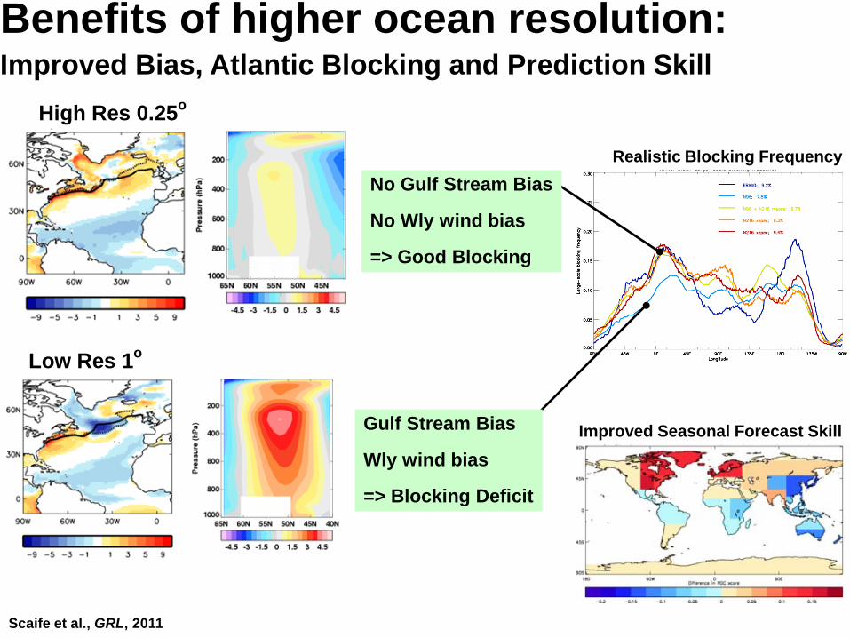
Scaife et al., GRL, 2011
Realistic Blocking Frequency
Benefits of higher ocean resolution: Improved Bias, Atlantic Blocking and Prediction Skill
Gulf Stream Bias
Wly wind bias
=> Blocking Deficit
Low Res 1o
No Gulf Stream Bias
No Wly wind bias
=> Good Blocking
High Res 0.25o
Improved Seasonal Forecast Skill
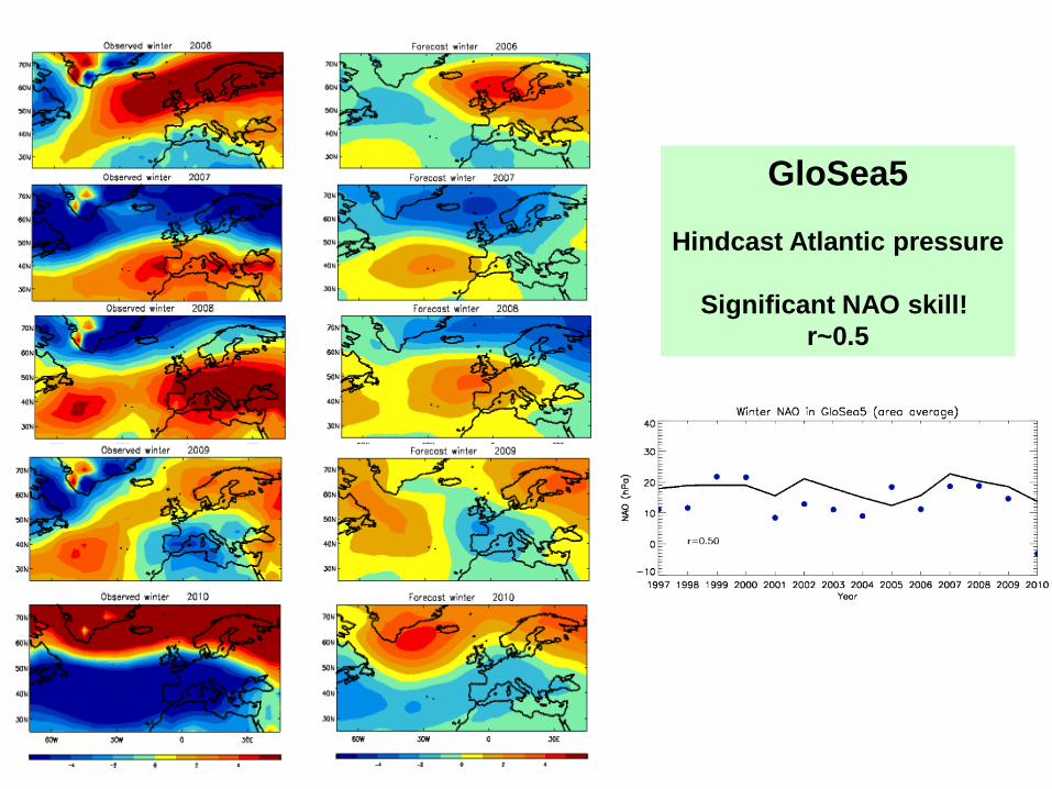
GloSea5
Hindcast Atlantic pressure
Significant NAO skill! r~0.5

Future: An international system KMA (Rep. of Korea)
• Joint seasonal forecast system • Shared workload and to extend hindcast
NCMRWF (India) • Implementing GloSea for research
Seamless with Med-range (2013): Research project to merge MOGREPS-15 and GloSea5 for med-range in 2013
Seamless with Decadal (~2014): GloSea5 will be extended – in research mode - to decadal timescales in 2013

Modelling and prediction across timescales – Decadal prediction Doug Smith, Nick Dunstone, Rosie Eade, Leon Hermanson, Adam Scaife MOSAC/SRG, 14-16 November 2012 © Crown copyright Met Office

Decadal Prediction System
DePreSys Range: 10 years Model: HadCM3
Resolution: N48L19O(1.25) Initialisation: Relaxation to atmos + ocean analysis
Method: Anomaly initialization Ensembles: 10 members, random perturbations
Hindcasts: 1st November 1960 to 2009 Forecasts: Updated annually (1st Sep)
Reference: Smith et al., 2007

© Crown copyright Met Office (Eade et al. in press)
Skill of temperature extremes
• Significant skill, especially for multi-year periods, but lower than mean
• Arises from climate change signal • Hindcasts start Nov 1st each year 1960 to 2005, with 9 ensemble members
• Assess extremes using daily data, Moderate extremes (10th percentile)
• 4 definitions (e.g. cold days, cold nights, warm days, warm nights)

© Crown copyright Met Office (Eade et al. in press)
Skill of wet extremes
• Some skill, but much lower than for temperature
• Can be higher than the mean – larger trends in extremes
• Initialization improvements up to two years • Assessed from daily data
• Wet: precipitation rate greater than 90th percentile (of rainy days)
© Crown copyright Met Office
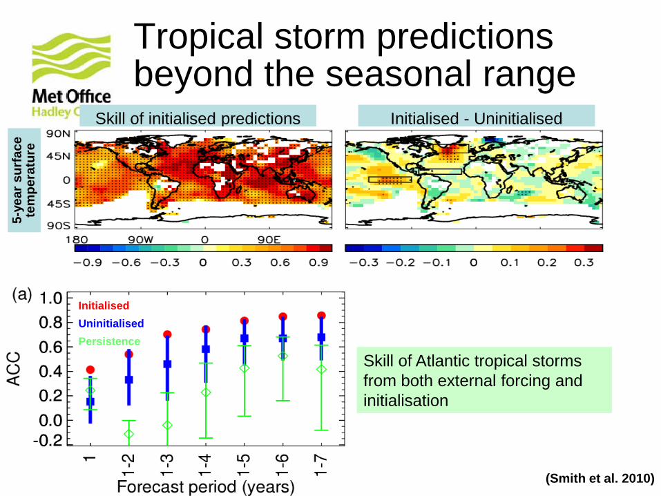
Tropical storm predictions beyond the seasonal range
(Smith et al. 2010)
Initialised Uninitialised Persistence
Skill of Atlantic tropical storms from both external forcing and initialisation
Initialised - Uninitialised Skill of initialised predictions
5-ye
ar s
urfa
ce
tem
pera
ture

© Crown copyright Met Office
External forcing of tropical storms
Dunstone et al., submitted
Booth et al., 2012
Nor
th A
tlant
ic S
ST
Observations Model

© Crown copyright Met Office
Impact of aerosols on near future (2010 to 2040)
Dunstone et al., submitted
Surf
ace
te
mpe
ratu
re
Circ
ulat
ion
• Aggressive aerosol mitigation in RCP2.6 ⇒ reduced cooling (more warming) in N. Atlantic ⇒ stronger anomalous Hadley circulation ⇒ ITCZ shifts north ⇒ more storms
Stor
ms
2010 2050 2100
Also noted by Villarini and Vecchi 2012

© Crown copyright Met Office (Smith et al. submitted)
Anomaly vs Full Field Initialization DJF precipitation (months 2-4)
Observations
El Niño – La Niña rainfall composites
Hindcast skill • Skill in areas related to El Niño
• Stronger teleconnections in full field ⇒ higher skill
• Teleconnections depend on underlying state
• Highlights need for improved models

© Crown copyright Met Office
Exchange of decadal predictions
(Smith et al. submitted)
Multi-model forecast of 2011
• Many groups have now developed decadal prediction systems for CMIP5
• What about the coming decade?
• Met Office coordinate an informal exchange of near real-time predictions
• 9 dynamical + 3 empirical
• High skill for first annual mean
• Initialized are cooler than uninitialized projections (except N. Atl and N. Pac)
Impact of initialization on 2012-16

Upgraded Decadal Predictions
DePreSys2 Range: 10 years Model: HadGEM3
Resolution: N96L85O(1) Initialisation: Relaxation to atmos + ocean analysis
Method: Anomaly initialization Ensembles: 10 members, random perturbations
Hindcasts: 1st November 1960 to 2009 Forecasts: Updated annually (1st Nov)
Reference: Knight et al., 2013 (in prep)
© Crown copyright Met Office
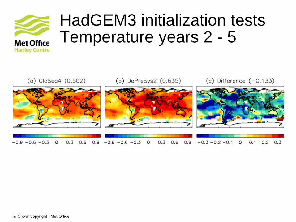
HadGEM3 initialization tests Temperature years 2 - 5

© Crown copyright Met Office
HadGEM3 vs HadCM3 Temperature years 2 - 5
Modelling and prediction across timescales – High-resolution climate modelling Malcolm Roberts, et al MOSAC/SRG, 14-16 November 2012 © Crown copyright Met Office

A partnership in weather and climate research
Joint Weather and Climate Research Programme
High resolution climate
modelling research
Malcolm Roberts, Matthew Mizielinski,
Lizzie Kendon, Stuart Webster + Met Office (with thanks to the many MO groups
involved in model development etc)
Pier Luigi Vidale, Marie-Estelle Demory,
Reinhard Schiemann, Jane Strachan
+ NCAS-Climate
MOSAC/SRG Nov 2012

Joint Weather and Climate Research Programme A partnership in climate research
N96
130km
N144
90km
N216
60km
N320
40km N512
25km N768
17km N1024
12km
ORCA1
1°
ORCA025
0.25°
ORCA12
0.08°
MetUM global atmosphere/coupled model climate configurations in use
Ocean/sea-ice
Atmosphere/land
Essentially the same physics/dynamics parameters used throughout model hierarchy
Explicit convection
GloSea5
Planned
UPSCALE
Project to assess impact of global explicit convection
Texas UK-ESM1?

Joint Weather and Climate Research Programme A partnership in climate research
Progress + plans (NCAS-Climate + Met Office projects)
• UJCC-HiGEM projects (2004-8) – Coupled 90km atm – 1/3° ocean; 60km atmosphere-only
• HadGEM3/CAPTIVATE/INTEGRATE/HRCM projects – Develop higher resolution HadGEM3-AO model
• UPSCALE (2011-12) lead by Prof Vidale – 5 member ensemble of 25km atmosphere-only (present day + future
timeslice) – 144M Cray core hours from PrACE (European supercomputing)
• To look at variability and extremes (e.g. 2003 European heat wave, recent cold winters, blocking)
• predictability of tropical cyclone numbers • Explicit convection (2012-)
– 12km global model with explicit convection (no parameterisation) • Diurnal cycle, MJO and global impact (motivated by CASCADE)
• Planned
– Texas/JPL/JWCRP – coupled 25km atmos-ocean + convection-permitting over US domain
– Coupled explicit convection/eddy-resolving

Joint Weather and Climate Research Programme A partnership in climate research
Resolution is not all about small-
scale detail
• Large-scale errors common to all resolutions can lead to important differences elsewhere – Little change in radiation, big changes in global water cycle – There are indications of convergence at resolutions of order 40-
60km
• Blocking generally thought to be large-scale – Convection-permitting model can represent drought duration
much more realistically
• Resolving basic large-scale features – For example ocean boundary currents

Energy budget in HadGEM-family AGCMs
Adapted from Trenberth et al., 2009, 2011
Fluxes: W/m2
Energy balance at TOA and surface Globally too much surface SW radiation compared to observations and reanalyses Excess in latent heat and precipitation consistent with excess in OLR
Demory et al, in prep

Over land
Robustness of results member ensembles HadGAM1 & HadGEM3-A: 2 different models with different water budgets Same tendency with resolution: convergence around N216-N320
High local recycling Low transport
Resolution Lower local recycling Higher transport
Demory et al, in prep

Joint Weather and Climate Research Programme A partnership in climate research
Atlantic basin interannual variability
OSTIA-forced climate
integrations
Correlations : with HURDAT
N96 0.63 N216 0.69 N512 0.72
UPSCALE project (PrACE), P.L. Vidale

Joint Weather and Climate Research Programme A partnership in climate research
Tropical cyclone track density (transits per month)

Joint Weather and Climate Research Programme A partnership in climate research
Tropical cyclone track density (transits per month)
© Crown copyright Met Office
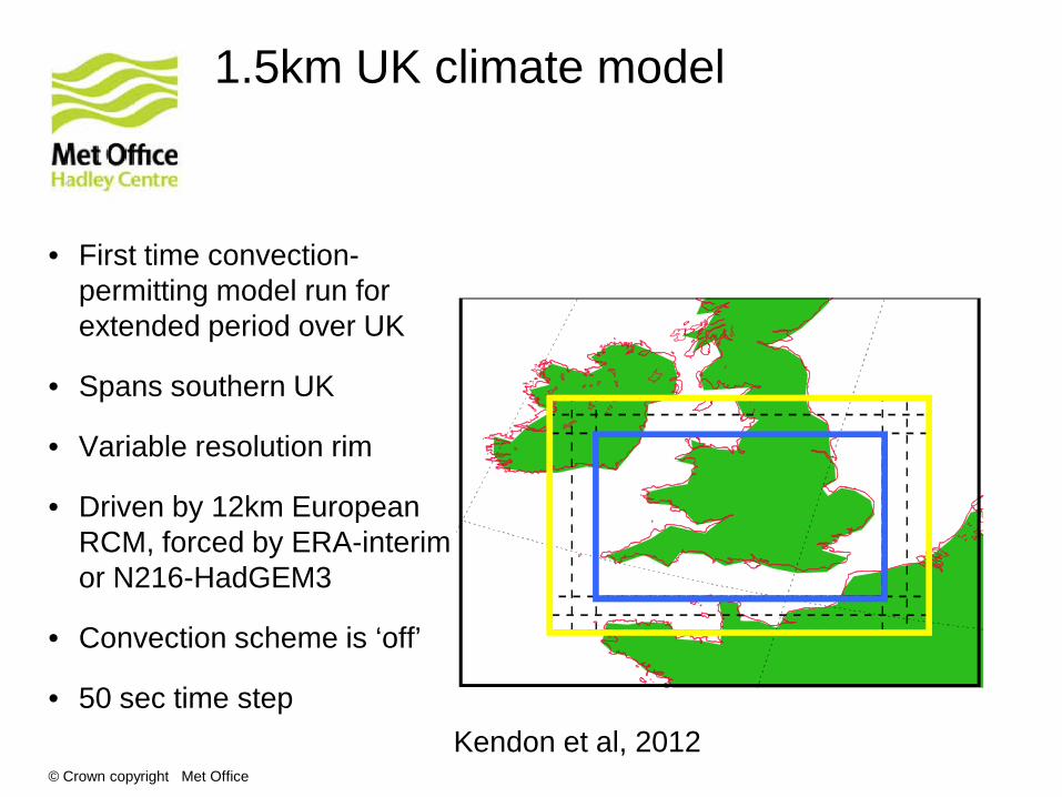
1.5km UK climate model
• First time convection-permitting model run for extended period over UK
• Spans southern UK
• Variable resolution rim
• Driven by 12km European RCM, forced by ERA-interim or N216-HadGEM3
• Convection scheme is ‘off’
• 50 sec time step Kendon et al, 2012

© Crown copyright Met Office
Peak intensity 20
10
5
2
1
0.5
0.2
0.1
20
10
5
2
1
0.5
0.2
0.1
Radar 12km-radar
1.5km-12km 1.5km-radar 1 6 12 18 24 36 72 hr 1 6 12 18 24 36 72 hr
1 6 12 18 24 36 72 hr 1 6 12 18 24 36 72 hr
0.001 0.005 0.02 0.1 -0.02 -0.005 0 0.005 0.02
Joint probability distribution of rain spell duration versus peak amount. [Rain > 0.1mm/h]
Spell duration versus peak intensity
© Crown copyright Met Office
Nested Indian monsoon simulations
• EMBRACE project
• Using Stuart Webster’s nesting suite to look at Indian monsoon
• very powerful and cheap way to examine resolution, parameter changes on particular processes
• Can also be used to look at tropical cyclones, e.g. Hurricane Katrina
• swebster_EMBRACE_1page.ppt

Joint Weather and Climate Research Programme A partnership in climate research
Future plans • Analysis and understanding
– Work with cloud (and cloud-system) resolving models to understand/improve parameterisations
– Coupling to eddy+boundary current resolving ocean model – Understanding where models converge, e.g. based on emerging processes – Scale interactions:
• Clouds and climate • TCs and their contributions to global energy+water cycles • Planetary waves, blocking, feedbacks with land surface anomalies (heatwaves, droughts)
• Applications to study of climate change
– Model suitable for decadal scenario integrations – N512 future timeslice (2100) runs to look at changes in variability, e.g.
tropical cyclones – SUKV runs forced by global 60km model (present day + future) to look
at possible future changes in extreme precipitation
• Future projects – Collaboration with UTexas@Austin & JPL – 12km global integrations with explicit convection – Coupling to the ORCA12 eddy-resolving ocean – Welsh Extreme Weather Initiative using SUKV model

Joint Weather and Climate Research Programme A partnership in climate research
Local time of peak precipitation (diurnal cycle) – Mar-Apr 2008
N1024 (12km) with (top) and without
(middle) convective
parameterisation, with TRMM
observations (bottom)

Diurnal cycle with and without parameterised convection over the Maritime Continent
mosac_movie_jun_aug.avi

Joint Weather and Climate Research Programme A partnership in climate research
Questions

Joint Weather and Climate Research Programme A partnership in climate research
Extra slides

How resolution affects the hydrological cycle: a study with an atmospheric GCM
Adapted from Trenberth et al., 2007, 2011
Storage: 103km3, Fluxes: 103km3/year For water vapour transport from ocean to land: (i) atmospheric moisture convergence (ii) E - P from the ocean (iii) P - E from the land
Biases in climate models: too intense water cycle (P and E too high): common in IPCC models Water budget well balanced in climate models: not always the case in reanalyses: MERRA: (E-P)ocean = -1 Moisture transport (ocean to land or land to ocean) way too low at N48 resolution
These 3 numbers should be equal
Demory et al, in prep

© Crown copyright Met Office
Prolonged drought in SUKV model

Joint Weather and Climate Research Programme A partnership in climate research
Precipitation in JJA 2005 from range of global climate model resolutions (135km 12km) and observations

Joint Weather and Climate Research Programme A partnership in climate research
Proposed collaboration with Texas/JPL
• Submission of NSF-XCEDE proposal • Study water cycle globally and over US
– Global coupled 25km model – Regional models at convection-permitting scales (4km and
1.5km)

© Crown copyright Met Office
High resolution regional experiments
For UK/Europe:
• ERA-interim driven (1989-2008) 12km and 1.5km experiments (complete)
• N216-HadGEM3 driven – 8 experiments (ongoing):
For US:
• N512-HadGEM3 driven 4km and 1.5km experiments spanning continental US (planned JPL/UTexas collaboration)
12km
1.5km
Control (1996-2010)
Future (15y, ~2100) Prescribed aerosol
Aerosol modelling

Resolution : Eddy KE DJF
Paul Earnshaw, Sean Milton, David Walters
•5 Day Forecasts - 10 DJF Case Studies
• Initialised from N320 analyses
•Resolutions spanning N48 (250km) to N768 (17km)
•GA3.0 Physics & L70

© Crown copyright Met Office
Questions?

Summary: “Modelling and prediction across time scales”
• Baseline global coupled configuration: N216L85 atmosphere, ORCA0.25L75 ocean.
• Built, assessed and evaluated across time scales in INTEGRATE
• Supported by a developing research effort in coupled NWP, including assessment of links to errors in climate simulations
• Implementation in a new monthly to seasonal prediction system (GloSea5)
• Project in progress to create a merged medium-range to seasonal coupled EPS.
• Interannual to decadal system has moved to HadGEM3 (N96/ORCA1.0), with plans to explore benefits of N216/ORCA0.25.
• Benefits of higher global atmospheric resolution (N320/N512/N768/N1024) also under investigation through collaborative projects
• Research in high resolution modelling and ensemble design looking at multidecadal climate projection issues, as well as shorter time scales.
© Crown copyright Met Offices