merkel & associates, inc. - san diego county, …...merkel & associates, inc. has prepared...
TRANSCRIPT

Merkel & Associates, Inc. 5434 Ruffin Road, San Diego, CA 92123 Tel: 858/560-5465 Fax: 858/560-7779 e-mail: [email protected]
December 10, 2012 Revised June 18, 2013
M&A #11-071-03 Mr. Patrick Mahoney FMHC Corporation 4060 Campus Drive, Suite 200 Newport Beach, CA 92660
Biological Resource Letter Report Verizon® Wireless Wildcat Canyon Project [County of San Diego Case/Environmental Log
Numbers 3300-12-001 (MUP)/3910 12-14-001]
Dear Mr. Mahoney:
Merkel & Associates, Inc. has prepared the following biological resource letter report for the
County of San Diego, written in accordance with the County of San Diego Report Format and
Content Requirements [for] Biological Resources, Fourth Revision (County 2010b).
If you have any questions concerning this biological letter report, please do not hesitate to
contact me, or Keith Merkel at (858) 560-5465 or [email protected] and
Sincerely, Amanda K. Gonzales Senior Biologist/Project Manager Keith W. Merkel County Approved Biological Consultant
SDC PDS RCVD 06-25-13 MUP12-001

Biological Resource Letter Report
Verizon® Wireless Wildcat Canyon Project Page 2 of 30 Merkel & Associates, Inc. #11-071-03
SUMMARY
Merkel & Associates, Inc. (M&A) has prepared this biological resource letter report for the
proposed Verizon® Wireless Wildcat Canyon Project. The purpose of this report is to document
the existing biological conditions within the project study area; identify potential impacts to
biological resources that could result from implementation of the proposed project; and
recommend measures to avoid, minimize, and/or mitigate significant impacts consistent with
federal, state, and local rules and regulations under the California Environmental Quality Act
(CEQA), including the County of San Diego (County) Resource Protection Ordinance (RPO)
(2007) and Guidelines for Determining Significance [for] Biological Resources, Fourth Revision
(2010a).
The project site is located on privately owned and Ramona Municipal Water District (RMWD)
lands [Assessors Parcel Number (APN) 288-070-18 and 288-662-27], on a moderately steep,
southeastern-facing hillside, within the draft North County MSCP Subarea, Pre-Approved
Mitigation Area (PAMA), overlooking the Barona Indian Reservation to the south.
The project is a Major Use Permit for a new Verizon® Wireless Communication Facility. The
utilities serving the proposed project have been designed to avoid crossing existing RMWD and
San Diego Gas and Electric (SDGE) easements, existing main water line, and existing utility
conduits. This project includes the following installations: a set-up transformer at the existing
SDGE meter and installation of a Verizon® Wireless electrical meter pedestal on a concrete pad,
all located at the existing RMWD pump station at the end of Barona Mesa Road; placement of an
underground power/telco utility conduit running from the new transformer west up to 1,655 feet
(south of the existing easements primarily within undeveloped lands) to the existing San Diego
Country Estates (SDCE) water tank (Booth & Suarez 2012). Please note that at the eastern
terminus of this underground conduit there are two utility route options proposed for installation
within the RMWD pump station, Utility Route Option 1 and 2. Utility Route Option 1 is four
feet inside the northern fence line and Option 2 is four feet inside the southern fence line. As we
understand, only one of the two options would ultimately be constructed as part of the proposed
project. Other installations include: a new prefabricated equipment shelter on a poured in place
concrete pad within a fenced enclosure with a Verizon® Wireless microwave antenna pipe
mounted to it; one enclosed emergency generator with a diesel tank on a concrete pad and
containment curb, all located within an existing equipment area near the water tank. Other
components to be installed include two telco and two electrical pull boxes along the alignment,
and an extra conduit for RMWD. As part of this work, a temporary stockpile and concrete wash
out area would be setup within the existing fenced boundary of the water tank and if required, a
stabilized construction entrance would be temporarily setup along the paved road leading to the

Biological Resource Letter Report
Verizon® Wireless Wildcat Canyon Project Page 3 of 30 Merkel & Associates, Inc. #11-071-03
water tank. Storm water management for the site is included within the project plans. No
landscaping or irrigation is proposed for this project.
The study area is comprised primarily of southern mixed chaparral habitat. This sparsely
covered habitat is dominated by shrubs such as chamise (Adenostoma fasciculatum), laurel
sumac (Malosma laurina), and Ramona lilac (Ceanothus tomentosus). A path of lower-growing
vegetation dominated by California buckwheat (Eriogonum fasciculatum) and common
deerweed (Lotus scoparius) is apparent along the existing Ramona Water District waterline that
parallels the proposed underground power/telco utility line and is assumed to be the result of a
previous disturbance and possible hydroseed event.
No special status floral species were identified onsite. A single special status faunal species was
identified on the project site during the biological survey: turkey vulture (Cathartes aura), a
County Group 1 species.
The federally listed threatened coastal California gnatcatcher (Polioptila californica californica)
was not detected on the project site during the habitat assessment and no suitable habitat for use
by this species was found within or adjacent to the project site.
No evidence of jurisdictional wetlands within the study area was identified during the biological
survey. However, there is potential for four jurisdictional waterways (Drainages 1-4) to occur
within the study area. These waterways are expected to be natural, rather than from erosion and
regulated as upland streambeds under Section 1602 of the California Fish and Game Code.
Drainages 1-3 are located outside the project footprint and would not be impacted. Drainage 4
crosses at the underground power/telco utility line but would be avoided by using boring
construction methods rather than open trench construction methods and trench plates (or similar)
would be placed for vehicles to temporarily cross the drainage (Land Use and Development 2012
pers. com). If significant nexus to traditional navigable water were determined through the U.S.
Army Corps of Engineers’ (ACOE) Jurisdictional Determination process, Drainage 4 would also
be regulated under Section 404 of the Clean Water Act (CWA) and Section 401 of the CWA.
Drainage 4 is approximately one-foot wide and one-foot in depth. If impacts to jurisdictional
non-wetland waters of the U.S./streambed were to occur, the following permits would be
required by regulatory federal and state agencies: 1) ACOE, CWA, Section 404 permit for
placement of dredged or fill material within waters of the U.S.; 2) Regional Water Quality
Control Board (RWQCB), CWA, Section 401 state water quality certification/waiver for an
action that may result in degradation of waters of the State; and 3) California Department of Fish
and Game, California Fish and Game Code, Section 1602 agreement for alteration of a
streambed prior to impacts to the drainage.

Biological Resource Letter Report
Verizon® Wireless Wildcat Canyon Project Page 4 of 30 Merkel & Associates, Inc. #11-071-03
The southern mixed chaparral habitat found within the project area does not contain rare or
endangered flora or fauna and due to the limited size of project area and previous disturbance it
is not considered critical to the proper functioning of a balanced natural ecosystem or serve as a
functioning wildlife corridor. Thus, the project site is not considered to consist of RPO Sensitive
Habitat Land.
Based on a preliminary steep slope analysis performed by M&A Geographical Information
System Specialists, the study area is expected to contain approximately 25% and greater up to
50% slope with a minimum rise of 50 feet as measured vertically from the toe of the slope at the
pump station to the top of the slope at the water tank. Thus, the study area is expected to consist
of RPO Steep Slope Lands. Per the County RPO (2007, Section 86.604), permitted uses on
Steep Slope Lands include: “Public and private utility systems, provided that findings are made
that the least environmentally damaging alignment has been selected.” The proposed project is a
Major Use Permit for a new Verizon® Wireless Communication Facility on a site where two
existing cellular wireless telecommunications facilities exist (i.e., AT&T® and T-Mobile®).
The utility route location has been designed as part of the proposed project to avoid crossing an
existing Ramona Water District and SDGE easement, existing main water line, and existing
utility conduit. The proposed utility route is now south of these existing features. As a result,
the proposed project is expected to represent the least environmentally damaging alignment; is
not subject to the encroachment limitations set forth within Section 86.604 of the County RPO
and thus would not conflict with the provisions of this ordinance.
The proposed project is located within southern mixed chaparral, disturbed habitat, and
urban/developed lands. Temporary, direct impacts to southern mixed chaparral would be
incurred from trenching for the placement of the underground power/telco utility line. These
impacts would be significant under CEQA and would require habitat-based mitigation to reduce
impacts to a level below significance and ensure compliance with the Guidelines for
Determining Significance [for] Biological Resources, Fourth Revision (2010a). Impacts to
southern mixed chaparral within the PAMA should be mitigated at a 0.5:1 ratio by purchasing
into an available conservation bank within the PAMA.
Potential indirect impacts would be limited to adverse edge effects such as the establishment of
non-native vegetation and potential erosion after the placement of the underground power/telco
utility line. While the project includes storm water management for the site, construction period
and post-construction best management practices (BMPs) are not currently proposed over the
underground power/telco utility line. Implementation of the BMPs (e.g., straw wattles or similar
and erosion control blanket, respectively) over the underground power/telco utility line would be
necessary to reduce impacts to a level less than significant under CEQA.

Biological Resource Letter Report
Verizon® Wireless Wildcat Canyon Project Page 5 of 30 Merkel & Associates, Inc. #11-071-03
The following construction design measures should also be implemented to ensure avoidance of
impacts to adjacent native chaparral habitat:
1. During project construction, all trenching activities should be monitored by a Biological
Monitor, alternatively the construction corridor may be fenced with temporary
construction fencing and verified by the Biological Monitor prior to initiation of
construction in order to ensure against damage to adjacent biological resources.
Additional duties of the biologist should include weekly inspection of erosion control
measures during construction and prior to and following rain events, and report
deficiencies immediately to the Contractor’s Site Superintendent and the Department of
Public Works Construction Inspector.
2. Upon completion of the proposed project, the biologist should prepare a letter report
documenting dates and times that the biologist was at the site as well as photographs of
the erosion control measures before and after project construction. The report will also
include a verification of the extent of impacts. The report should be submitted to the
Department of Planning and Land Use Permit Compliance Coordinator.
Nesting birds may be present within the project footprint during construction. Since avian
species could potentially nest on-site, the proposed project could result in impacts to active
migratory bird nests (if present at the time of construction) under the federal Migratory Bird
Treaty Act (MBTA) and/or California Department of Fish and Game Code Sections 3503 and
3513; therefore, the project mitigation measure listed below is recommended.
1. If construction of the proposed project would occur during the migratory bird
breeding season (generally defined as January 15 – September 15), a pre-construction
survey for active migratory bird nests should be conducted within approximately 48
hours prior to the start of construction. The results of the survey should be submitted
to the County in the form of a written report, and should include the following
information: a) date(s) of survey, b) total field time of survey efforts, c) name(s) of
investigator(s), and d) if any active nests were found. If an active migratory bird nest
were found, then all construction activities undertaken for the project shall comply
with regulatory requirements of the federal MBTA and California Fish and Game
Codes §3503 and §3513.

Biological Resource Letter Report
Verizon® Wireless Wildcat Canyon Project Page 6 of 30 Merkel & Associates, Inc. #11-071-03
INTRODUCTION, PROJECT DESCRIPTION, LOCATION, SETTING
Merkel & Associates, Inc. (M&A) has prepared this biological resource letter report for the
proposed Verizon® Wireless Wildcat Canyon Project. The purpose of this report is to document
the existing biological conditions within the project study area; identify potential impacts to
biological resources that could result from implementation of the proposed project; and
recommend measures to avoid, minimize, and/or mitigate significant impacts consistent with
federal, state, and local rules and regulations under the California Environmental Quality Act
(CEQA), including the County of San Diego (County) Resource Protection Ordinance (RPO)
(2007) and Guidelines for Determining Significance [for] Biological Resources, Fourth Revision
(2010a).
The project study area is located on privately owned and Ramona Water District lands
[Assessors Parcel Number (APN) 288-070-18 and 288-662-27, respectively] within an un-
incorporated area of northern eastern San Diego County. The property lies within a land grant
and as such was never part of the original public domain and not subject to subdivision by the
Public Lands Survey System (i.e., no section, township, range information). The property is
located within U.S. Geological Survey (USGS) 7.5’ El Cajon Mountain, California Quadrangle
(Figure 1).
The project study area is located on a moderately steep, southeastern-facing hillside, with an
approximate elevation change of 1,540 to 1,850 feet above mean sea level (MSL). On-site soils
are mapped from west to east as Olivenhain cobbly loam, 30 to 50 percent slopes, Vista rocky
coarse sandy loam, 30 to 65 percent slopes, Anderson very gravelly sandy loam, 9 to 45 percent
slopes, and Wyman loam, 5 to 9 percent slopes (USDA NRCS 2011). The property consists of
an existing Ramona Water District Pump Station, Telecom facility (i.e., AT&T® and T-
Mobile®), San Diego Country Estates (SDCE) water tank, and surrounding native chaparral
habitat. The pump station and water tank are bound by chain link fencing. Adjacent land uses
include residential developed, private undeveloped, and the Barona Indian Reservation directly
to the south of the study area. An approximate four-foot barbed wire fence separates the study
area from the Barona Indian Reservation.
The project is a Major Use Permit for a new Verizon® Wireless Communication Facility. The
utilities serving the proposed project have been designed to avoid crossing existing Ramona
Municipal Water District (RMWD) and San Diego Gas and Electric (SDGE) easements, existing
main water line, and existing utility conduits. This project includes the following installations: a
set-up transformer at the existing SDGE meter and installation of a Verizon® Wireless electrical

Project Vicinity MapVerizon® Wireless, Wildcat Canyon Project Figure 1
M&A #11-071-03
Merkel & Associates, Inc.
µ Source: USGS 7.5' El Cajon Mtn, CA Quadrangle1:24000
_̂
Project Site

Biological Resource Letter Report
Verizon® Wireless Wildcat Canyon Project Page 8 of 30 Merkel & Associates, Inc. #11-071-03
meter pedestal on a concrete pad, all located at the existing RMWD pump station at the end of
Barona Mesa Road; placement of an underground power/telco utility conduit running from the
new transformer west approximately 1,596 feet (south of the existing easements primarily within
undeveloped lands) to the existing San Diego Country Estates (SDCE) water tank (Booth &
Suarez 2012). Please note that at the eastern terminus of this underground conduit there are two
utility route options proposed for installation within the RMWD pump station, Utility Route
Option 1 and 2. Utility Route Option 1 is four feet inside the northern fence line and Option 2 is
four feet inside the southern fence line. As we understand, only one of the two options would
ultimately be constructed as part of the proposed project. Other installations include: a new
prefabricated equipment shelter on a poured in place concrete pad within a fenced enclosure with
a Verizon® Wireless microwave antenna pipe mounted to it; one enclosed emergency generator
with a diesel tank on a concrete pad and containment curb, all located within an existing
equipment area near the water tank. Other components to be installed include two telco and two
electrical pull boxes along the alignment, and an extra conduit for RMWD. As part of this work,
a temporary stockpile and concrete wash out area would be setup within the existing fenced
boundary of the water tank and if required, a stabilized construction entrance would be
temporarily setup along the paved road leading to the water tank. Storm water management for
the site is included within the project plans.
Access to the site would be provided by an existing paved road off of Calistoga Place that leads
up to the water tank, and also from the Ramona Water District pump station at the end of Barona
Mesa Road. No road improvements are proposed.
The proposed Verizon® Wireless Communication Facility does meet the intent of County Fire
Protection (FP) 2 Policy (County 2006, 2013).
Long-term maintenance of cellular wireless facilities typically occurs by remote computer, with
as-needed site visits approximately every one to three month.
M&A has conducted the following surveys on the project site for the proposed Verizon®
Wireless cellular facility: vegetation mapping and botanical/wildlife survey, directed sensitive
species survey/assessment, and a habitat assessment for the federally listed threatened coastal
California gnatcatcher (Polioptila californica californica) (Table 1). In September 2012, a site
meeting with Verizon® Wireless representatives was conducted. The study area included 100
feet beyond all proposed project elements (excluding Utility Route Option 2) and the site access
road. The portions of the study area along the proposed underground power/telco utility trench
line that were located on the adjacent Barona Indian Reservation property were visually surveyed
only from the proposed underground utility trench line.

Biological Resource Letter Report
Verizon® Wireless Wildcat Canyon Project Page 9 of 30 Merkel & Associates, Inc. #11-071-03
Table 1. Survey Dates and Times
Survey Date Time Conditions
(start to end) Biologist(s)
General Biology CAGN Assessment
2011 Sep 19
0845 – 1143
Weather: 0% cc Wind: 0-2 BS Temperature: 85-90 F
Bonnie L. Peterson Mary C. Tamburro
Habitat Verification/ Site Meeting
2012 Sep 26
0900-1000
Weather: 0% cc Wind: 1 BS Temperature: 76 F
Bonnie L. Peterson
CAGN = coastal California gnatcatcher; cc = cloud cover; BS = Beaufort Scale; F = degrees Fahrenheit
REGIONAL CONTEXT
The study area is located in the draft North County MSCP Subarea (County 2009). The property
is located approximately two-thirds of a mile south of San Vicente Creek and is located within
the San Vicente hydrological area of the San Diego River Watershed. The entire property is
located inside of the Pre-Approved Mitigation Area (PAMA) (County 2009, Figure 1).
Specifically, the study area is located at the southern terminus of the PAMA and bound to the
south by Barona Indian Reservation lands and to the west and east by residential development.
HABITATS/VEGETATION COMMUNITIES
Four vegetation types were identified within the study area during the biological survey (Table 2;
Figures 2a and 2b). A complete list of the floral species observed and the faunal species
observed or detected within the study area during the biological survey have been included with
this report in Attachments 1 and 2, respectively.
Table 2. Habitats/Vegetation Communities
Vegetation Type Holland/Oberbauer
Code Wetland/Upland
Existing (acres)
Southern Mixed Chaparral 37120 Upland 7.3Eucalyptus Woodland 79100 Upland 0.2Disturbed Habitat 11300 Upland 0.3Urban/Developed 12000 Upland 2.5
Total: 10.3
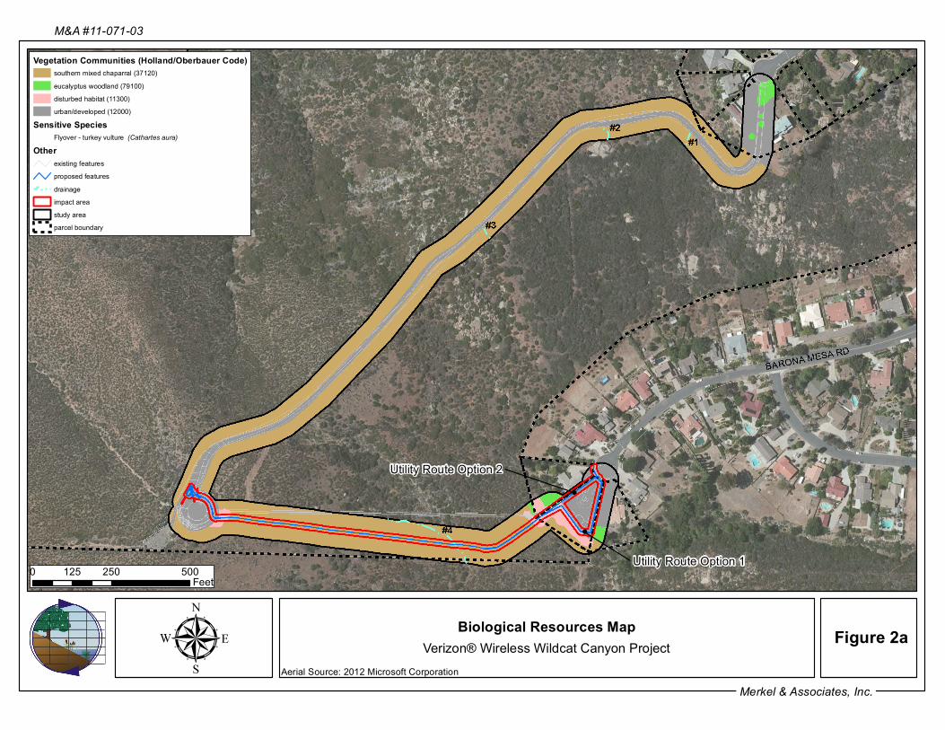
µMerkel & Associates, Inc.
M&A #11-071-03
Biological Resources MapVerizon® Wireless Wildcat Canyon Project Figure 2a
Vegetation Communities (Holland/Oberbauer Code)southern mixed chaparral (37120)eucalyptus woodland (79100)disturbed habitat (11300)urban/developed (12000)
Sensitive SpeciesFlyover - turkey vulture (Cathartes aura)
Otherexisting featuresproposed featuresdrainageimpact areastudy areaparcel boundary
0 250 500125Feet
Utility Route Option 2
Utility Route Option 1
Aerial Source: 2012 Microsoft Corporation

µMerkel & Associates, Inc.
M&A #11-071-03
Biological Resources MapVerizon® Wireless Wildcat Canyon Project Figure 2b
Vegetation Communities (Holland/Oberbauer Code)southern mixed chaparral (37120)eucalyptus woodland (79100)disturbed habitat (11300)urban/developed (12000)
Sensitive SpeciesFlyover - turkey vulture (Cathartes aura)
Otherexisting featuresproposed featuresdrainageimpact areastudy areaparcel boundary
0 250125Feet
Utility Route Option 2
Utility Route Option 1
Aerial Source: 2012 Microsoft Corporation

Biological Resource Letter Report
Verizon® Wireless Wildcat Canyon Project Page 12 of 30 Merkel & Associates, Inc. #11-071-03
The study area is composed mostly of southern mixed chaparral habitat. This sparsely covered
habitat is dominated by shrubs such as chamise (Adenostoma fasciculatum), laurel sumac
(Malosma laurina), and Ramona lilac (Ceanothus tomentosus). A path of lower-growing
vegetation dominated by California buckwheat (Eriogonum fasciculatum) and common
deerweed (Lotus scoparius) is apparent along the existing Ramona Water District waterline that
parallels the proposed underground power/telco utility trench and is assumed to be the result of a
previous disturbance and possible hydroseed event. While the characteristic chaparral shrubs
that are dominant throughout the rest of the study area are self-recruiting within this lower
growing area, they are not dominant.
The existing paved access road and water tank were mapped as urban/developed. This road is
flanked on either side by southern mixed chaparral dominated by chamise and mission manzanita
(Xylococcus bicolor), species commonly found in chaparral habitats. A cement brow ditch runs
the length of the road to direct surface run-off into three potential ephemeral drainages. In
addition, the Ramona Water District pump station was mapped as urban/developed. It is
bordered to north and south by residential urban development and to the west by disturbed
habitat and/or eucalyptus woodland habitats.
The study area is adjacent to urban development and therefore many of the avian species were
associated with that development. The species included mourning dove (Zenaida macroura),
western scrub-jay (Aphelocoma californica), American crow (Corvus brachyrhynchos), house
finch (Carpodacus mexicanus), and lesser goldfinch (Spinus psaltria). There were also a number
of commonly encountered chaparral related species observed within the study area including:
California quail (Callipepla californica), Anna’s hummingbird (Calypte anna), and wrentit
(Chamaea fasciata). Both turkey vulture (Cathartes aura) and red-tailed hawk (Buteo
jamaicensis) were observed foraging over the site. Regionally common avian species such as the
California towhee (Pipilo crissalis) and spotted towhee (Pipilo maculates) are likely to be found
on-site as well.
The County RPO restricts impacts to various natural resources including wetlands, Sensitive
Habitat Lands, and Steep Slopes (County 2010a, Section 2.3). The County RPO (2007) defines
“Sensitive Habitat Lands” as: “Land which supports unique vegetation communities, or the
habitats of rare or endangered species or sub-species of animals or plants as defined by Section
15380 of the State CEQA Guidelines (14 Cal. Admin. Code Section 15000 et seq.), including the
area which is necessary to support a viable population of any of the above species in perpetuity,
or which is critical to the proper functioning of a balanced natural ecosystem or which serves as
a functioning wildlife corridor. ‘Unique vegetation community’ refers to associations of plant
species, which are rare or substantially depleted. These may contain rare or endangered species,

Biological Resource Letter Report
Verizon® Wireless Wildcat Canyon Project Page 13 of 30 Merkel & Associates, Inc. #11-071-03
but other species may be included because they are unusual or limited due to a number of factors,
for example: (a) they are only found in the San Diego region; (b) they are a local representative
of a species or association of species not generally found in San Diego County; or (c) they are
outstanding examples of the community type as identified by the California Department of Fish
and Game (CDFG) listing of community associations.” Thus, County RPO Sensitive Habitat
Lands include, but may not be limited to: lands that include populations of sensitive species (i.e.,
federally and state listed species, County List A plant species, and County Group 1 wildlife
species); lands that contain unique vegetation communities, as defined above (e.g., maritime
succulent scrub, southern coastal bluff scrub, coastal and desert dunes, calcicolous scrub,
maritime chaparral, valley sacaton grassland, hardpan and claypan vernal pools, montane
meadows, mesquite bosque, native grassland, and Torrey pine forest); and additional vegetation
communities (e.g., coastal sage scrub, oak woodland, chaparral, and non-native grassland) if they
include populations of sensitive species (i.e., federally and state listed species, County List A
plant species, and County Group 1 wildlife species), or are critical to a balanced ecosystem, or
are part of a functioning wildlife corridor (County 2010a, Section 2.3).
The southern mixed chaparral habitat found within the project area does not contain rare or
endangered flora or fauna and due to the limited size of project area including the nature of the
impact which is a utility trench and the development on the surrounding lands it is not considered
critical to the proper functioning of a balanced natural ecosystem or serve as a functioning
wildlife corridor. Thus, the project site is not considered to consist of RPO Sensitive Habitat
Land.
SPECIAL STATUS SPECIES
The County Report Guidelines for Determining Significance [for] Biological Resources (2010a)
define “sensitive species” as “those species that are included on generally accepted and
documented lists of plants and animals of endangered, threatened, candidate or of special
concern by the Federal Government or State of California; MSCP Rare, Narrow Endemic
Animal Species, Narrow Endemic Plant Species, and County Sensitive Plant and Animal
Species; and those species that meet the definition of ‘Rare or Endangered Species’ under
§15380 of the State CEQA Guidelines.”
State CEQA Guidelines §15380 (Title 14, Chapter 3, Article 20) define “endangered, rare or
threatened species” as “species or subspecies of animal or plant or variety of plant” listed under
the Code of Federal Regulations, Title 50, Part 17.11 or 17.12 (Volume 1, Chapter I) or
California Code of Regulations, Title 14, Sections 670.2 or 670.5 (Division 1, Subdivision 3,
Chapter 3), or a species not included in the above listings but that can be shown to be

Biological Resource Letter Report
Verizon® Wireless Wildcat Canyon Project Page 14 of 30 Merkel & Associates, Inc. #11-071-03
“endangered” meaning “when its survival and reproduction in the wild are in immediate
jeopardy from one or more causes, including loss of habitat, change in habitat, overexploitation,
predation, competition, disease, or other factors” or “rare” meaning “although not presently
threatened with extinction, the species is existing in such small numbers throughout all or a
significant portion of its range that it may become endangered if its environment worsens or the
species is likely to become endangered within the foreseeable future throughout all or a
significant portion of its range and may be considered ‘threatened’ as that term is used in the
Federal Endangered Species Act”. State CEQA guidelines Appendix G, Section IV generally
refers to species that fall under the above criteria as “special status species”.
Thus, for the purposes of this report, special status species are: 1) federally and state listed
species (CDFG 2011b and e); 2) CDFG Species of Special Concern (SSC), Fully Protected (FP),
and Watch List (WL) species (CDFG 2011a and d); 3) species designated as Special Plants or
Special Animals in the CNDDB, which include all taxa inventoried by the CDFG, regardless of
their legal or protection status; 4) MSCP Narrow Endemic and Covered Species; and 5) species
designated as sensitive by the County of San Diego (County 2010c).
No special status floral species were identified onsite. A single special status faunal species was
identified on the project site during the biological survey: turkey vulture.
The turkey vulture is a County of San Diego Group 1 species (County 2010c). This species uses
extensive open areas with protective roost sites provided by large trees, snags, thickets, shrubs,
and nest in the crevices of rock outcrops. Nesting locations are difficult to detect because they
typically lay their eggs on bare ground, with little or no construction of an actual nest. This
species hunts from the air or by perch, aided by the sense of smell, and feeds primarily on carrion
(AOU Birds of North America On-line 2011 and CDFG 2011f). One turkey vulture was seen
foraging over the project site throughout the biological survey.
An assessment for suitable habitat was conducted for the coastal California gnatcatcher. This
species is not expected to occur on the project site based on the lack of suitable habitat within the
study area as well as the surrounding lands. Nesting locations for the coastal California
gnatcatcher most commonly are associated with Diegan coastal sage scrub, in which the
community is dominated by California sagebrush (Artemesia californica), California buckwheat,
and sages (Salvia sp.) (USFWS 1997). The coastal California gnatcatcher may also use
chaparral habitat when that habitat occurs adjacent or intermixed with sage scrub. The study
area and surrounding lands are dominated by chaparral species such as Ramona lilac and
chamise. California buckwheat, a species found equally within chaparral and sage scrub
communities is present in limited coverage throughout the study area as well as immediately

Biological Resource Letter Report
Verizon® Wireless Wildcat Canyon Project Page 15 of 30 Merkel & Associates, Inc. #11-071-03
adjacent to the study area; however, the overall presence of sage scrub constituents is low and
there is no Diegan coastal sage scrub habitat adjacent to the study area. It should be noted that
approximately 20 California sagebrush plants are located within immediate proximity to the
proposed underground power/telco utility line which runs parallel to the Ramona Water District
main water line and existing T-Mobile® utility conduits; however, no additional plants were
noted onsite or adjacent to the site. Regionally, the closest recorded detection for the coastal
California gnatcatcher is approximately one mile north of the study area, just north of San
Vicente Wastewater Reclamation Plant within Diegan coastal sage scrub (CDFG 2011c, USFWS
2011, Unitt). The detection occurred in 2002, prior to the 2003 Cedar Wildfires which has since
temporarily displaced the species due to lack of suitable habitat.
The project site has a low potential to be utilized by large special status mammals, such as
southern mule deer (Odocoileus hemionus fuliginata) and mountain lion (Felis concolor) based
on the lack of mule deer evidence detected during the biological survey and the lack of favored
habitat on the property. Mule deer occur in intermediate successional stages of most forest,
woodland, and brush habitats, but prefer vegetation that provides woody cover, meadow and
shrubby openings, and perennial water sources (CDFG 2011f). Mountain lion movement closely
follows its primary prey, mule deer; however, the property may be located within a portion of a
much larger territory range for this species. Both the southern mule deer and mountain lion are
on the County Sensitive Animal List (Group A) (County 2010c), and mountain lion is a covered
species under the draft North County MSCP Subarea Plan (County 2009, Table 6-2).
An evaluation of the occurrence potential for additional special status species on the project site,
based on the list provided in the County project scoping letter for the originally proposed
AT&T® Wireless, Ramona Water District Country Estates Water Tank #4 Project, dated
September 12, 2011, has been included with this report in Attachment 3.
The project site has a potential to be utilized by other regionally common migratory birds and
raptors that are not designated as special status species under CEQA, but are protected under the
Migratory Bird Treaty Act (MBTA). The site consists of potential nesting habitat for some
chaparral associated migratory birds observed on-site, and foraging habitat only for other
migratory birds and raptors. No avian nests were observed on-site during the biological survey;
however, migratory birds observed that have a potential to nest in the chaparral habitat on-site
include wrentit. Wrentit’s nest between March and July, and typically construct a small nest cup
in the crotch of two supporting branches of a shrub (AOU 2011). One red-tailed hawk was
observed foraging over the project area during the biological survey; however, the project site
does not provide potentially suitable nesting habitat for this species (i.e., tall trees). The other

Biological Resource Letter Report
Verizon® Wireless Wildcat Canyon Project Page 16 of 30 Merkel & Associates, Inc. #11-071-03
avian species observed on-site during the biological survey (see Attachment 2) do not typically
nest in chaparral habitat, but the site does provide potential foraging habitat.
JURISDICTIONAL WETLANDS AND WATERWAYS
No evidence of jurisdictional wetlands within the study area was identified during the biological
survey. However, there is potential for four jurisdictional waterways (Drainages 1-4) to occur
within the study area (Table 3; Figure 2a and b).
Table 3. Jurisdictional Waterways
Expected acreage Jurisdictional Waterway ACOE, RWQCB,
CDFG, County CDFG Total
Non-wetland water (Drainages 1-4) 0.0 <0.1 <0.1Total: 0.0 <0.1 <0.1
Drainages 1 through 3 are associated with the paved access road to the water tank. An existing
brow ditch along the northwestern side of this road crosses three times for run-off to flow down
the southeast facing slope. The brow ditch has been excavated in association with the access
road in an upland area that does not carry relatively permanent flow of water and as such would
not be regulated as a streamed by the resource and/or regulatory agencies [U.S. Army Corps of
Engineers (ACOE) 2008]. However, the three drainages on the southeast side of the paved road
are expected to be regulated as an upland streambed under section 1602 of the California Fish
and Game Code due to the presence of ordinary high water mark (OHWM) indicators;
specifically bed and bank incision patterns and a non-hydric soil substratum. The drainages
range in width by approximately one to five feet and in depth by approximately one to two feet.
Based on site conditions and an aerial review, it is probable that the drainages are isolated and do
not connect to traditional navigable waters. These drainages would not be impacted as no
improvements to the road are proposed.
Drainage 4 is located within the southern portion of the study area. It is expected to be regulated
under section 1602 of the California Fish and Game Code as a streambed due to the presence of
OHWM indicators, specifically bed and bank incision patterns and a non-hydric soil substratum.
Drainage 4 crosses the proposed Verizon® Wireless underground power/telco utility line and
flows south onto the Barona Indian Reservation; however, it is unknown if it connects to
traditional navigable waters. If connection to traditional navigable waters is present and/or if
connection is not present but a significant nexus to traditional navigable waters is determined
through the ACOE Jurisdictional Determination process, Drainage 4 would also be regulated

Biological Resource Letter Report
Verizon® Wireless Wildcat Canyon Project Page 17 of 30 Merkel & Associates, Inc. #11-071-03
under Section 404 of the Clean Water Act (CWA) and Section 401 of the CWA. It is
approximately one-foot wide and one-foot in depth. It should be noted that during the September
2012 site visit, the OHWM indicators were noted to be disturbed, potentially from vehicles
driving over the drainage. The vegetation within and surrounding this incised channel is
identical in cover and species composition as the surrounding disturbed and chaparral habitats.
This drainage does not support permanent flow and since the upper reach of the channel is
located approximately 100 feet northwest of the proposed Verizon® Wireless underground
power/telco utility line, it drains a very small watershed and is not expected to significantly
affect the chemical, physical and biological integrity of downstream drainages.
During the biological survey erosional features were identified along the proposed Verizon®
Wireless underground power/telco utility line and/or southeast of the line. These small, incised
features appear to be remnants from the prior disturbance associated with either the Ramona
Water District main water line or existing utility conduits. These features were identified as
“erosion” based on their short, segmented, and shallow nature. Resource and regulatory agencies
generally will not assert jurisdiction over swales or erosional features (e.g., gullies, small washes
characterized by low volume, infrequent, or short duration flow (USACOE 2008). It should be
noted that due to its location, it is possible that Drainage 4, at the proposed Verizon® Wireless
underground power/telco utility line is a result of, or has been expanded by erosion from prior
disturbance in this area. However, based on the presence of minor OHWM patterns upslope
from the utility line, it is presumed to be natural.
OTHER UNIQUE FEATURES/RESOURCES
As previously mentioned, the project site does not provide many unique biological functions in
terms of foraging, roosting, or large rock outcrops, and is not considered to be County RPO
Sensitive Habitat Land.
SIGNIFICANCE OF PROJECT IMPACTS AND PROPOSED MITIGATION
Thresholds of Significance
State CEQA Guidelines §15065 (a) (Title 14, Chapter 3, Article 5) states, “A project may have a
significant effect on the environment” if:
“The project has the potential to substantially degrade the quality of the environment;
substantially reduce the habitat of a fish or wildlife species; cause a fish or wildlife
population to drop below self-sustaining levels; threaten to eliminate a plant or animal

Biological Resource Letter Report
Verizon® Wireless Wildcat Canyon Project Page 18 of 30 Merkel & Associates, Inc. #11-071-03
community; substantially reduce the number or restrict the range of an endangered, rare or
threatened species; or eliminate important examples of the major periods of California
history or prehistory.”
“The project has possible environmental effects which are individually limited but
cumulatively considerable.”
The following analysis identifies potential impacts to biological resources that could result from
implementation of the proposed project, and addresses the significance of these impacts pursuant
to CEQA, in accordance with the Issues listed under CEQA Guidelines Appendix G, Section IV.
In addition, the County has developed Guidelines for Determining Significance [for] Biological
Resources, Fourth Revision (2010a) under CEQA; therefore, mitigation measures for significant
project impacts are recommended in accordance with these County guidelines, as well as the
County RPO (2007).
Impact and Mitigation Definitions
Project impacts are categorized pursuant to CEQA as direct, indirect, or cumulative impacts.
CEQA Guidelines §15358 (a) (1) and (b) (Title 14, Chapter 3, Article 20) defines a
“direct impact or primary effect” as “effects which are caused by the project and occur at
the same time and place” and relate to a “physical change” in the environment.
CEQA Guidelines §15358 (a) (2) and (b) (Title 14, Chapter 3, Article 20) defines an
“indirect impact or secondary effect” as “effects which are caused by the project and are
later in time or farther removed in distance, but are still reasonably foreseeable” and
relate to a “physical change” in the environment.
CEQA Guidelines §15355 (Title 14, Chapter 3, Article 20) defines “cumulative impacts”
as “two or more individual effects which, when considered together, are considerable or
which compound or increase other environmental impacts.”
Direct, indirect, and cumulative impacts can be described as either permanent or temporary.
Permanent impacts are generally defined as effects that would result in an irreversible loss of
biological resources; temporary impacts can be defined as effects that could be restored, thus
providing habitat and wildlife functions and values effectively equal to the functions and values
that existed before the area was impacted.
CEQA Guidelines §15370 (Title 14, Chapter 3, Article 20) defines “mitigation” as:

Biological Resource Letter Report
Verizon® Wireless Wildcat Canyon Project Page 19 of 30 Merkel & Associates, Inc. #11-071-03
“Avoiding the impact altogether by not taking a certain action or parts of an action.”
“Minimizing impacts by limiting the degree or magnitude of the action and its
implementation.”
“Rectifying the impact by repairing, rehabilitating, or restoring the impacted environment.”
“Reducing or eliminating the impact over time by preservation and maintenance operations
during the life of the action.”
“Compensating for the impact by replacing or providing substitute resources or
environments.”
Project Impacts, Significance, and Recommended Mitigation
Potential project impacts were evaluated based on examination of the proposed project plans
within the context of the biological resources documented during the field surveys, and those
biological resources assessed as having a likely potential to occur in the project area. Direct
impacts were determined by overlaying the project plans on the mapped vegetation
communities/habitats and sensitive species in GIS Environmental Systems Research Institute
(ESRI) software platforms. A 20-foot buffer area along the power/telco route was used to
quantify the permanent and temporary direct impacts anticipated to occur from trenching for the
underground placement of the power/telco utility line. Indirect impacts were determined based
on the design, intended use, and location of the proposed project elements relative to biological
resources.
Special Status Species
A single special status faunal species, the turkey vulture, was seen foraging over the project area
during the biological survey. This species is not expected to nest onsite and therefore would not
be significantly impacted by project construction.
Potential direct and indirect impacts to those special status species with a low or moderate
potential to occur in the study area (see Attachment 3) would be less than significant under
CEQA. Potentially present reptile, bird, and mammal species would likely be able to flee the
small project area and move to other nearby habitat during trenching for the underground
power/telco utility line.

Biological Resource Letter Report
Verizon® Wireless Wildcat Canyon Project Page 20 of 30 Merkel & Associates, Inc. #11-071-03
Habitats/Vegetation Communities
Potential impacts to native habitat have also been minimized by designing the proposed
Verizon® Wireless underground power/telco utility line to be located parallel with the existing
Ramona Water District easement. Specifically, the proposed Verizon® Wireless utility trench is
located immediately adjacent to a path of native vegetation that appears to have been previously
disturbed and subsequently reseeded with common low-growing shrubs in association with either
above-mentioned facility.
The proposed project would result in temporary direct impacts to southern mixed chaparral from
trenching for the placement of the underground power/telco utility line (Table 3; see Figure 2b).
These impacts would be considered significant under CEQA.
Impacts to southern mixed chaparral within the PAMA should be mitigated at a 0.5:1 ratio by
purchasing into an available conservation bank within the PAMA. This would reduce impacts to
a level less than significant under CEQA.
Impacts to the disturbed and urban/developed areas would be less than significant under CEQA
since these habitats are not regionally considered to have high conservation value requiring
mitigation.
Potential indirect impacts would be limited to adverse edge effects such as the establishment of
non-native vegetation and potential erosion after the placement of the underground power/telco
utility line. While the project includes storm water management for the site, construction-period
and post-construction period best management practices (BMPs) are not currently proposed over
the underground power/telco utility line. Implementation of the BMPs (e.g., straw wattles or
similar and erosion control blanket, respectively) over the underground power/telco utility line
would be necessary to reduce potential indirect impacts to a level less than significant under
CEQA.

Biological Resource Letter Report
Verizon® Wireless Wildcat Canyon Project Page 21 of 30 Merkel & Associates, Inc. #11-071-03
Table 3. Habitats/Vegetation Communities, Impacts, and Mitigation
Vegetation Type Existing (acres)1
On-Site Impacts (acres)1,2
Off-SiteImpacts(acres)
Mit
igat
ion
R
atio
3 Mitigation Required
(acres)
PreservedOn-Site (acres)
Impact Neutral (acres)
Off-Site Mitigation
(acres)
Southern Mixed Chaparral 7.3 0.5 0.0 0.5:1 0.25 0.0 N/A 0.25Eucalyptus Woodland 0.2 0.0 0.0 None 0.0 N/A N/A N/ADisturbed Habitat 0.3 0.1 0.0 None 0.0 N/A N/A N/AUrban/Developed 2.5 0.2 0.0 None 0.0 N/A N/A N/A
Total: 10.3 0.8 0.0 0.25 0.0 N/A 0.251 All existing and on-site impact acreages are located within the PAMA. 2 A difference in impacts exists between Utility Route Option 1 and 2; however, due to rounding to the nearest tenth both options result in the same impact
acreage and mitigation requirement. Please note that Utility Route Option 1 would impact 0.10 acres of disturbed habitat and 0.19 acres of urban/developed areas while Utility Route Option 2 would impact 0.06 acres of disturbed habitat and 0.18 acres of urban/developed areas.
3 The mitigation ratios are based on the Guidelines for Determining Significance [for] Biological Resources, Fourth Revision (2010a). N/A = Not Applicable
Biological Resource Letter Report
Verizon® Wireless Wildcat Canyon Project Page 22 of 30 Merkel & Associates, Inc. #11-071-03
The following construction design measures should also be implemented to ensure avoidance of
impacts to adjacent native chaparral habitat:
1. During project construction, all trenching activities should be monitored by a Biological
Monitor, alternatively the construction corridor may be fenced with temporary construction
fencing and verified by the Biological Monitor prior to initiation of construction in order to
ensure against damage to adjacent biological resources. Additional duties of the biologist
should include weekly inspection of erosion control measures during construction and prior
to and following rain events, and report deficiencies immediately to the Contractor’s Site
Superintendent and the Department of Public Works Construction Inspector.
2. Upon completion of the proposed project, the biologist should prepare a letter report
documenting dates and times that the biologist was at the site as well as photographs of the
erosion control measures before and after project construction. The report will also include a
verification of the extent of impacts. The report should be submitted to the Department of
Planning and Land Use Permit Compliance Coordinator.
Jurisdictional Wetlands and Waterways
The proposed project would not result in impacts to jurisdictional wetlands since none were
identified on or adjacent to the project site during the biological surveys. Direct impacts to
Drainage 4, a non-wetland water expected to be regulated under Section 1602 of the California
Fish and Game Code as a streambed and potentially under Section 404 and 401 of the CWA,
would be avoided by using jack and boring construction methods under the drainage (rather than
open trench construction techniques) and trench plates (or similar) would temporarily be placed
over the drainage to allow for vehicle access during construction of the project (Land Use and
Development 2012 pers. com). If impacts to jurisdictional non-wetland waters of the
U.S./streambed were to occur, the following permits would be required by regulatory federal and
state agencies: 1) ACOE, CWA, Section 404 permit for placement of dredged or fill material
within waters of the U.S.; 2) Regional Water Quality Control Board (RWQCB), CWA, Section
401 state water quality certification/waiver for an action that may result in degradation of waters
of the State; and 3) CDFG, California Fish and Game Code, Section 1602 agreement for
alteration of a streambed.
Wildlife Movement and Nursery Sites
Based on the small nature of the project and relatively open, undeveloped land immediately
surrounding the property, project development and maintenance of the facility would not create

Biological Resource Letter Report
Verizon® Wireless Wildcat Canyon Project Page 23 of 30 Merkel & Associates, Inc. #11-071-03
artificial wildlife corridors or interfere with connectivity to off-site habitat, or substantially limit
access to potential foraging or breeding habitat, or water sources necessary for the successful
reproduction of resident wildlife species.
Local Policies, Ordinances, and Adopted Plans
The following federal laws/regulations and local ordinances/plans are applicable to the proposed
project, and are evaluated below for consistency purposes.
Federally Designated Critical Habitat
No federally designated critical habitat is found within or adjacent to the project area.
Federal Migratory Bird Treaty Act (MBTA) and California Fish and Game Code
Under the MBTA of 1918 (16 U.S.C. section 703-712; Ch. 128; July 3, 1918; 40 Stat. 755; as
amended 1936, 1956, 1960, 1968, 1969, 1974, 1978, 1986 and 1998), it is unlawful, except as
permitted by the USFWS, to “take, possess, transport, sell, purchase, barter, import, or export all
species of birds protected by the MBTA, as well as their feathers, parts, nests, or eggs (USFWS
2003). Take means to pursue, hunt, shoot, wound, kill, trap, capture, or collect, or attempt to
pursue, hunt, shoot, wound, kill, trap, capture, or collect (50 CFR 10.12). Birds protected by the
MBTA include all birds covered by the treaties for the protection of migratory birds between the
United States and Great Britain (on behalf of Canada, 1916), Mexico (1936), Japan (1972), and
Russia (1976), and subsequent amendments.”
It is important to note that since the MBTA addresses migratory birds by family rather than at a
lower taxonomic level, most bird species are protected by the MBTA because most taxonomic
families include migratory members. In addition, “take” as defined under the federal MBTA is
not synonymous with “take” as defined under the federal ESA. The MBTA definition of “take”
lacks a “harm and harassment” clause comparable to “take” under the ESA, thus, the MBTA
authority does not extend to activities beyond the nests, eggs, feathers, or specific bird parts (i.e.,
activities or habitat modification in the vicinity of nesting birds that do not result in “take” as
defined under the MBTA are not prohibited). Further, “a permit is not required to dislodge or
destroy migratory bird nests that are not occupied by juveniles or eggs; however, any such
destruction that results in take of any migratory bird is a violation of the MBTA (i.e., where
juveniles still depend on the nest for survival) (USFWS 2003).”
Sections 3503, 3503.5, and 3513 of the California Fish and Game Code prohibit the “take,
possession, or destruction of bird nests or eggs.” Section 3503 states: “It is unlawful to take,

Biological Resource Letter Report
Verizon® Wireless Wildcat Canyon Project Page 24 of 30 Merkel & Associates, Inc. #11-071-03
possess, or needlessly destroy the nest or eggs of any bird, except as otherwise provided by this
code or any regulation made pursuant thereto.” Section 3503.5 provides a refined and greater
protection for birds-of-prey and states: “It is unlawful to take, possess, or destroy any birds in the
orders Falconiformes or Strigiformes (birds-of-prey) or to take, possess, or destroy the nest or
eggs of any such bird except as otherwise provided by this code or any regulation adopted
pursuant thereto.” The distinctions made for birds-of-prey are the inclusion of such birds
themselves to the protections and the elimination of the term “needlessly” from the language of
§3503. Section 3513 states: “It is unlawful to take or possess any migratory nongame bird as
designated in the MBTA or any part of such migratory nongame bird except as provided by rules
and regulations adopted by the Secretary of the Interior under provisions of the Migratory Treaty
Act.”
The definition of “take” under the California Fish and Game Code is not distinct from the
definition of “take” under California Endangered Species Act (CESA), which is defined as
“hunt, pursue, catch, capture, or kill, or attempt to hunt, pursue, catch, capture, or kill”
(California Fish and Game Code §86); however, it is important to note that the state definition of
“take” again does not include a “harm and harassment” clause, and thus, activities or habitat
modification in the vicinity of nesting birds that do not result in “take” as defined under the
California Fish and Game Code/CESA are not prohibited.
Since avian species could potentially nest in the onsite habitats, the project could result in
impacts to active bird nests (if present at the time of construction) under the federal MBTA
and/or CDFG Code Sections 3503 and 3513; therefore, the project mitigation measure listed
below is recommended.
1. If construction of the proposed project would occur during the migratory bird breeding
season (generally defined as January 15 – September 15), a pre-construction survey for active
migratory bird nests should be conducted within approximately 48 hours prior to the start of
construction. The results of the survey should be submitted to the County in the form of a
written report, and should include the following information: a) date(s) of survey, b) total
field time of survey efforts, c) name(s) of investigator(s), and d) if any active nests were
found. If an active migratory bird nest were found, then all construction activities undertaken
for the project shall comply with regulatory requirements of the federal MBTA and
California Fish and Game Codes §3503 and §3513.
County of San Diego Resource Protection Ordinance (RPO)
The proposed project would not result in impacts to Sensitive Habitat Lands as defined under the
County RPO.

Biological Resource Letter Report
Verizon® Wireless Wildcat Canyon Project Page 25 of 30 Merkel & Associates, Inc. #11-071-03
The County RPO (2007) defines “Steep Slopes” as: “All lands having a slope with natural
gradient of 25% or greater and a minimum rise of 50 feet, unless said land has been substantially
disturbed by previous legal grading. The minimum rise shall be measured vertically from the toe
of the slope to the top of the slope within the project boundary.”
M&A Geographical Information System (GIS) Specialists conducted a preliminary slope
analysis using 40-foot wide SANDAG topographical data as extracted from the USGS
quadrangles. Based on the preliminary analysis, the study area contains approximately 25% and
greater up to 50% slope with a minimum rise of 50 feet as measured vertically from the toe of
the slope at the pump station to the top of the slope at the water tank. As a result, the study area
is expected to consist of RPO Steep Slope Lands. Per the County RPO (2007, Section 86.604),
permitted uses on Steep Slope Lands include: “Public and private utility systems, provided that
findings are made that the least environmentally damaging alignment has been selected.” The
proposed project is a Major Use Permit for a new Verizon® Wireless Communication Facility on
a site where two existing cellular wireless telecommunications facilities exist (i.e., AT&T® and
T-Mobile®). The utility route location has been designed as part of the proposed project to
avoid crossing an existing Ramona Water District and SDGE easement, existing main water line,
and existing utility conduit. The proposed utility route is south of these existing features and as
such is located adjacent to a path of previous disturbance that resulted from the existing features.
As a result, the proposed project represents the least environmentally damaging alignment; is not
subject to the encroachment limitations set forth within Section 86.604 of the County RPO and
thus would not conflict with the provisions of this ordinance.
CUMULATIVE IMPACTS
Pursuant to CEQA Guidelines §15130 (b) (1) (Title 14, Chapter 3, Article 9), “…an adequate
discussion of significant cumulative impacts [would include] either: a list of past, present, and
probable future projects producing related or cumulative impacts, including, if necessary, those
projects outside the [jurisdiction] of the agency; or a [referenced] summary of projections
contained in an adopted general plan or related planning document, or in a prior environmental
document [that] has been adopted or certified, which described or evaluated regional or area-
wide conditions contributing to the cumulative impact.”
Cumulative biological impacts within this area of northern San Diego County have not been
analyzed under an “adopted” regional plan; however, the County has released their Public
Review Draft North County MSCP Plan (February 19, 2009), thus, information from this
regional planning document is referenced for this project cumulative impact analysis.

Biological Resource Letter Report
Verizon® Wireless Wildcat Canyon Project Page 26 of 30 Merkel & Associates, Inc. #11-071-03
A project cumulative study area was delineated to analyze the effects of past, present, and
reasonably foreseeable projects that could cumulatively contribute to the project impacts to
coastal sage-chaparral scrub. The cumulative study area for the proposed project is defined as
the boundaries of the Draft North County MSCP Plan Area, which is considered to be the area
necessary for evaluation during the interim absence of an adopted Plan.
According to the Public Review Draft North County MSCP (County 2009, Table 6-1), the Plan
Area consists of approximately 75,865 acres of chaparral (eighty-eight percent of the total
vegetation), with 66,931 acres designated in the PAMA. Present hardline projects include
development impacts to approximately 837 acres of chaparral (less than two percent of the total
chaparral), with 2,304 acres conserved in biological or other open space (County 2009, Table 4-
2). Potential future projects will also likely result in development impacts to chaparral.
Approximately 51,898 acres (78 percent) of the existing coastal sage scrub/chaparral in the Plan
Area is expected to be conserved within the PAMA (County 2009, Table 6-1).
The proposed project would result in a loss of southern mixed chaparral within the PAMA of 0.5
acres, and implementation of the habitat-based mitigation measures would ensure that impacts do
not expand from this extent. It should further be noted that the utility trench would result in
temporary disturbance of vegetation with the expectation that much, if not all of the corridor
would recover with time. The mitigation proposed to conserve lands within the PAMA in
conformance with guidance provided under the Guidelines for Determining Significance [for]
Biological Resources, Fourth Revision (2010a) would ensure that the cumulative impacts
resulting from the proposed project, when considering the effects of other projects anticipated to
occur in the region, would be reduced to a level below considerable under CEQA.

Biological Resource Letter Report
Verizon® Wireless Wildcat Canyon Project Page 27 of 30 Merkel & Associates, Inc. #11-071-03
REFERENCES
American Ornithologists’ Union (AOU) and Cornell Lab of Ornithology. 2011. Birds of North America On-line (Subscription) [Internet]. Available from: http://bna.birds.cornell.edu/bna.
Booth & Suarez. 2012. November 27 and December 3. PDF and AutoCAD files of Verizon® Wireless, Wildcat Canyon Project Plans. The most recent drawing date on the project plans is 11/20/12.
California Department of Fish and Game (CDFG). 2011a Jan. Special Animals [Internet]. Natural Diversity Database. 50 pp + Endnotes. Available from: http://www.dfg.ca.gov/biogeodata/cnddb/pdfs/SPAnimals.pdf.
_____. 2011b Jan. State and Federally Listed Endangered & Threatened Animals of California [Internet]. Natural Diversity Database. 13 pp. Available from: http://www.dfg.ca.gov/biogeodata/cnddb/pdfs/TEAnimals.pdf.
_____. 2011c. California Natural Diversity Database (CNDDB). Biogeographic Data Branch. RareFind 3; GIS shapefile update,June 2011. Sacramento, California.
_____. 2011d Jul. Special Vascular Plants, Bryophytes, and Lichens List [Internet]. Natural Diversity Database. Quarterly publication. 71 pp. Available from: http://www.dfg.ca.gov/biogeodata/cnddb/pdfs/SPPlants.pdf.
_____. 2011e Jul. State and Federally Listed Endangered & Threatened Plants of California [Internet]. Natural Diversity Database. 16 pp. Available from: http://www.dfg.ca.gov/biogeodata/cnddb/pdfs/TEAnimals.pdf.
_____. 2011f. Life History Accounts and Range Maps [Internet]. California Wildlife Habitat Relationships System. Edited by Zeiner DC, et al. 1988-1990, updated. Available from: http://www.dfg.ca.gov/biogeodata/cwhr/cawildlife.aspx.
California Natural Resources Agency. 2009. CEQA: The California Environmental Quality Act [Internet]. California Environmental Resources Evaluation System. Available from: http://ceres.ca.gov/ceqa/index.html.
County of San Diego. 2006. Fire Code Compliance for Cellular Facilities, Fire Protection (FP) 2 Policy. 2000, revised 2006. 3 pp. Available from: http://www.sdcounty.ca.gov/dplu/Resource/docs/3~pdf/POLICY%20FP-2.pdf.
______. 2007. Resource Protection Ordinance (No. 9842) [Internet]. Adopted 1989, Amended 1991, 2007. 18pp. Available from: http://www.sdcounty.ca.gov/dplu/index.html.
_____. 2009. Preliminary Draft North County MSCP Subarea Plan [Internet]. 147 pp + Appendices A through I. Available from: http://www.sdcounty.ca.gov/dplu/mscp/nc.html.

Biological Resource Letter Report
Verizon® Wireless Wildcat Canyon Project Page 28 of 30 Merkel & Associates, Inc. #11-071-03
_____. 2010a. Guidelines for Determining Significance and Report Format and Content Requirements [for] Biological Resources, Fourth Revision [Internet]. Land Use and Environment Group; Department of Planning and Land Use; Department of Public Works. 61pp. Available from: http://www.sdcounty.ca.gov/dplu/index.html.
_____. 2010b. Report Format and Content Requirements [for] Biological Resources, Fourth Revision [Internet]. Land Use and Environment Group; Department of Planning and Land Use; Department of Public Works. 41pp. Available from: http://www.sdcounty.ca.gov/dplu/index.html.
_____. 2010c. Sensitive Plant and Animal Lists [Internet]. Available from County of San Diego Guidelines for Determining Significance and Report Format and Content Requirements [for] Biological Resources, Fourth Revision (Tables 2 and 3): http://www.sdcounty.ca.gov/dplu/docs/Biological_Guidelines.pdf.
_____. 2011. Project application review/scoping letter package for the Ramona Water District Country Estates Wireless Telecommunications Facility Major Use Permit Modification [Case/Environmental Log Numbers 3301-08-008-02 (MUP) 3910 08-140-06A]. Department of Planning and Land Use. 7 pp. + Attachments A through H.
_____. 2012. Project application review/scoping letter package for the Ramona Municipal Water District Wireless Telecommunications Facility Major Use Permit [Case/Environmental Log Numbers 3300-12-001/3910 12-14-001]. Department of Planning and Land Use. 7 pp. + Attachments A through D.
_____. 2013. Project Application Amendment Form/Fish and Wildlife Fees/Document Request for the San Diego Country Estates Wireless Telecommunication Facility Major Use Permit [Record ID: PDS2012-3300-12-001; PDS2012-3910-1214001]. Department of Planning and Development Services. 6pp. + Attachments
Holland RF. 1986. Preliminary Descriptions of the Terrestrial Natural Communities of California. Nongame-Heritage Program, State of California, Resources Agency, Department of Fish and Game. Sacramento, California. 157pp.
Oberbauer T, Kelly M, Buegge J. 2008, Revised 1996 and 2006. Draft Vegetation Communities of San Diego County [Internet]. Based on “Preliminary Descriptions of the Terrestrial Natural Communities of California”, Holland RF, PhD., 1986. Available from: http://www.sdcounty.ca.gov/dplu/docs/Veg_Comm_SDCounty_2008.pdf
Land Use and Development Consulting. Email correspondence in December 2012. Between Mark Linman of Land Use and Development Consulting and Amanda Gonzales of Merkel & Associates, Inc. providing information regarding the project plans and construction methods/activities.
Ogden, in conjunction with the Resource Agencies, Local Jurisdictions, and members of environmental, building and development communities [Internet]. 1998. Final Multiple Species Conservation Program MSCP Plan. 8 sections + attachments. Available from: http://dplu-mscp.sdcounty.ca.gov//2_bmo/2FinalMSCPProgramPlan.pdf.

Biological Resource Letter Report
Verizon® Wireless Wildcat Canyon Project Page 29 of 30 Merkel & Associates, Inc. #11-071-03
Reiser CH. 2001 February. Rare Plants of San Diego County. Aquafir Press. 2001 edition. 299 pp.
Unitt P. 2004. San Diego County Bird Atlas. No. 30 Proceedings of the San Diego Society of Natural History. San Diego Natural History Museum and Ibis Publishing Company.
U.S. Army Corps of Engineers (USACOE). 2008 Jun 26. Regulatory Guidance Letter No. 08-02, Subject: Jurisdictional Determinations.
U.S. Department of Agriculture (USDA), Natural Resources Conservation Service (NRCS). 2011. Soil Survey Geographic (SSURGO) database for San Diego County, California [Internet]. Natural Resources Conservation Service (NRCS). Available from: http://SoilDataMart.nrcs.usda.gov/.
U.S. Fish and Wildlife Service (USFWS). 1997. Presence/Absence Survey Guidelines for the Coastal California Gnatcatcher (Polioptila californica californica). 5pp.
_____. Carlsbad Fish and Wildlife Office (CFWO). 2011. Carlsbad Fish and Wildlife Office, GIS Division Species Occurrence Data Download (zip) updated April 2011 [Internet]. Available from: http://www.fws.gov/carlsbad/giswebpage/giswebpage.
U.S. Geological Survey (USGS). 2011. Preliminary Integrated Geological Map Databases for the United States; Western States: California, Nevada, Arizona, Washington, Oregon, Idaho, and Utah. Version 1.2. GIS Data Download California (zip) [Internet]. Available from: http://pubs.usgs.gov/of/2005/1305/#CA.

Biological Resource Letter Report
Verizon® Wireless Wildcat Canyon Project Page 30 of 30 Merkel & Associates, Inc. #11-071-03
PREPARER(S) AND PERSONS/ORGANIZATIONS CONTACTED
Merkel & Associates, Inc. Amanda K. Gonzales, Senior Biologist/Project Manager and Contributing Author Mary C. Tamburro, Associate Biologist/Field Biologist Bonnie L. Peterson, Senior Biologist/ Field Biologist Brad M. Kelly, GIS Specialist/Graphics Preparation and Numeric Analyses Keith W. Merkel, County Approved Biological Consultant/Author and QA/QC