merged sea-ice thickness product from complementary l … · altimetry first-year / multi-year sea...
TRANSCRIPT

Merged sea-ice thickness product from complementary
L-band and altimetry information

Contributors
AWI Team Stefan Hendricks
Robert Ricker
Stephan Paul
University Hamburg
Team
Lars Kaleschke
Xiangshan Tian-Kunze
ESA CCI Team Eero Rinne
Stefan Kern
Kirill Khvorostovsky
FMI
University Hamburg
University St. Petersburg

Managing Expectations
100 mDigital Elevation Model with 25cm Resolution
(Airborne Laserscanner)
No satellite or model can resolve true variability of sea ice

SIT Remote Sensing
93 94 95 96 97 98 99 00 01 02 03 04 05 06 07 08 09 10 11 12 13 14 15 16 17 18
ERS-1
ERS-2
Envisat
IceSat
CryoSat-2
SMOS
AltiKa
SMAP
Sentinel-3A
Altimeter
Pulse-limited (Ku-Band)
Pulse-limited (Ka-Band)
SAR / SAR interferometric (Ku-Band)
Laser
Radiometer
L-Band

Radar Altimetry
Pioneering work by with ERS (Laxon et al. 2003)
Breakthrough for sea ice altimetry with CryoSat-2

Sea Ice Radar Altimetry
Step 1
Freeboard Retrieval
A Priori Information
Snow Depth
Step 2
Freeboard to
Thickness
Conversion
A Priori Information
Snow Depth
Snow Density
Sea Ice Density
Water Density
Main Uncertainty Sources
Complex radar echos
over rough sea ice surfaces
Potential bias from radar
backscatter in snow layer
Snow wave propagation
Main Uncertainty Sources
Freeboard uncertainties
Unknown regional and
temporal variability of
snow depth, snow
density and sea ice
density
Sea Ice Range
Measurement
Lead Range
Measurement

Radar Echo Waveforms
Time (Range)
Leading
Edge
Trailing
Edge
Peak Power
Surface Range
Tracking Point
Evolving radar altimeter concepts
(Improved footprints less surface type mixing)
Per echo waveform
surface type and range
off-nadir
and/or
sub-surface

Radar Altimeter Processing Chain
Primary Data
Geolocated Radar Echoes
External Auxiliary Data
Mean Sea Surface
Sea ice type / MYI area fraction
Sea Ice Concentration
Snow Depth / Density

Orbit Freeboard Example
Sea Surface Height

Radar Altimetry - Coverage
Daily Trajectory Weekly Grid Monthly Grid

CryoSat-2 – Central Arctic Volume
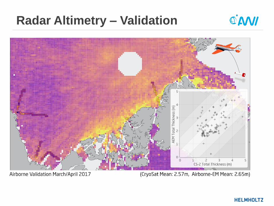
Radar Altimetry – Validation

Radar Altimetry – Precision
Monthly collection of daily cross-overs (25km window SIT differences)
Potential error sources: Range Noise | Sea-Surface Height | Selection Bias
Average CryoSat SIT precision: ~ 40 cm
Orbit A
Orbit B (t < 24h)
25 km

Product Intercomparison
MYI
Sea Ice Mass Reconciliation Exercise
(SIMRE)
ESA Arctic+ Theme 2 (Ice Mass)

Long-Term Data Records
Envisat thickness retrieval
calibrated at Envisat / CryoSat-2 overlap
consistent auxiliary datasets and snow assumptions
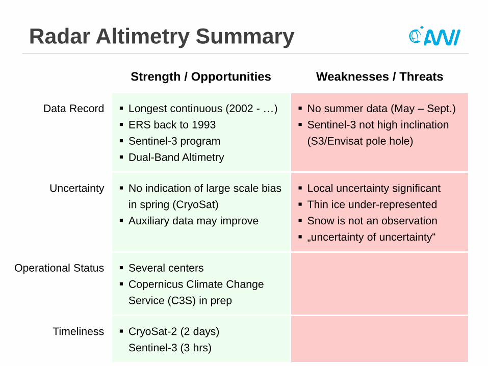
Radar Altimetry Summary
Strength / Opportunities Weaknesses / Threats
Data Record Longest continuous (2002 - …)
ERS back to 1993
Sentinel-3 program
Dual-Band Altimetry
No summer data (May – Sept.)
Sentinel-3 not high inclination
(S3/Envisat pole hole)
Uncertainty No indication of large scale bias
in spring (CryoSat)
Auxiliary data may improve
Local uncertainty significant
Thin ice under-represented
Snow is not an observation
„uncertainty of uncertainty“
Operational Status Several centers
Copernicus Climate Change
Service (C3S) in prep
Timeliness CryoSat-2 (2 days)
Sentinel-3 (3 hrs)

L-Band Radiometry
SMOS ice thickness: Support to Science Element
Utilize low-frequency radiometry for sea ice
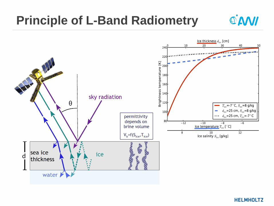
Principle of L-Band Radiometry
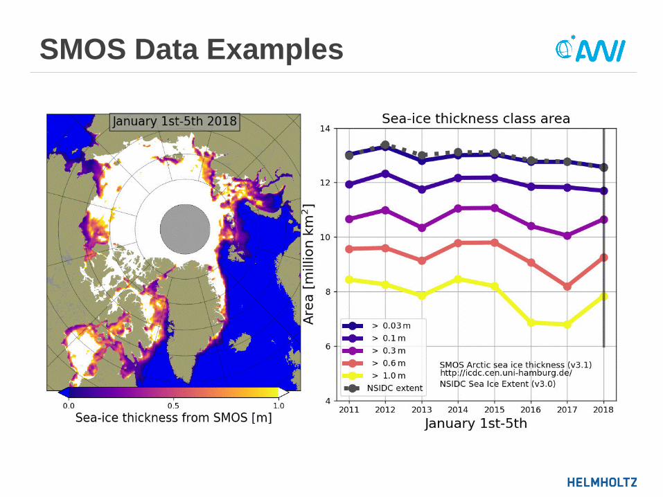
SMOS Data Examples

L-Band Radiometry Summary
Strength / Opportunities Weaknesses / Threats
Data Record Daily global coverage No summer data
SMOS follow-on?
Uncertainty Impact of snow might lead to
snow depth information
Upper thickness limit
Large footprint
Operational Status Operational (U. Hamburg)
Timeliness SMOS (2 days)

CryoSat-2 / SMOS Data Fusion
ESA Project: SMOS+ Sea Ice
Develop merged thickness prototype

Data Fusion Concept
CryoSat-2
L3 SIT
SMOS
L3 SIT
Optimal Interpolation
(weighted by uncertainties)
Merged
L4 SIT

Bridging Temporal Coverage
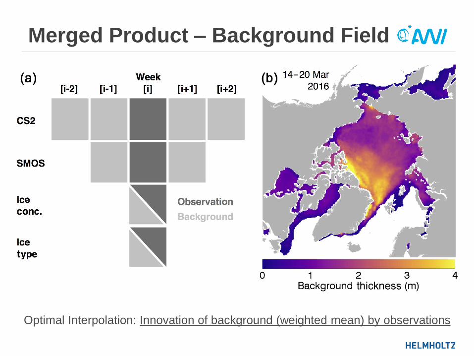
Merged Product – Background Field
Optimal Interpolation: Innovation of background (weighted mean) by observations

Weekly Thickness Fields

Merged Product – Coverage

Merged Product – Validation

Data Fusion Summary
Strength / Opportunities Weaknesses / Threats
Data Record Weekly gapless No summer data
Uncertainty The best of two worlds
(full thickness resolution)
Smoothing removes localized
features
Uncertainties depend on input
where one method dominates
Operational Status SMOS & CryoSat-2 Sea Ice
PDS in Q4 2018
Only reprocessed product
Timeliness Improved background field for
NRT (2 day) service

Conclusions – Product Guide
Use Don‘t use
Altimetry First-year / multi-year sea ice
Climate applications
(longest data record)
Young thin ice (freeze-up)
Areas close to ice edge
High coverage & temporal
resolution
Radiometry Daily observations of thin ice Older first-year, multi year ice
Merged Weekly observations for entire
northern hemisphere and
thickness range
You want to use observation
operators
You want to assimilate
observations individually
1 2 3 4 5 6 7 8 9 10

Thank you!
Ricker, R., Hendricks, S., Kaleschke, L., Tian-Kunze, X., King, J., and Haas, C. (2017):
A weekly Arctic sea-ice thickness data record from merged CryoSat-2 and SMOS satellite data
The Cryosphere
ftp://data.meereisportal.de
user: altim
password: altim
/altim/sea_ice/product/north/cryosat2-smos/cs2smos_v1.4/