membership year 2013 november 2013 la pintura - … · 2013-11-08 · membership year 2013 volume...
TRANSCRIPT

The Official Newsletter of the American Rock Art Research AssociationMember of the International Federation of Rock Art Organizations
http://www.arara.org
La Pintura Membership Year 2013 Volume 39, Number 4
November 2013
ARARA 2014 ConferenceBy Mavis Greer and James D. Keyser
RESERVE the 4th of July weekend for ARARA 2014
in Rock Springs, Wyoming. The meeting will be held at the Holiday Inn, and rooms have been reserved there without breakfast. There is a restaurant at the Holiday Inn, and other restaurants are nearby. But if you want your breakfast with your room, then consider the rooms that are also being held for ARARA at the Holiday Inn Express, which is immediately across the street from the conference venue. The streets will not be that busy in this oil boom town on the 4th of July as all oil workers will be off enjoying the holiday with their families. Information on making room reservations will soon be available on our arara.org website and announced in ARARA Online. The conference venue is conveniently located along I-80, which runs west to Salt Lake City (185 miles away) and east across the state of Wyoming. The Rock Springs–Sweetwater County airport is serviced by Delta Airlines, United Airlines, and Allegiant Air.
The Call for Papers will be issued by November 1, 2013, so please check arara.org for details. Plans are underway for Volume 41 of American Indian Rock Art (AIRA). Authors wishing to have papers published in that volume must meet a deadline of May 2, 2014, for receipt of a final reviewable copy of the paper to be considered for publication. This early deadline will not preclude anyone from presenting a paper at the Rock Springs conference, since any paper not submitted in time for Volume 41 can be considered for the subsequent AIRA volumes. Remember, Volume 40 was distributed at the 2013 conference, so no volume will be distributed in 2014, which returns us to our normal schedule of receiving the
...continued on next page
conference volume the following year.
This year our logo comes from a local area rock art site, Mud Springs. It and many local sites will provide a full suite of Friday and Monday field trips. We are working to finalize access permissions and field trip leaders, and details will be available after the New Year.
Southwestern Wyoming has great rock art to offer visitors, and ARARA members have great research presentations to offer attendees. We will have a special presentation on the rock
art of Oman (on the Arabian Peninsula) by Italian colleague Angelo Fossati, who has been recording and studying the rock art of that country for the last three years.
This year we also have a banquet guest who offers a unique and entertaining look at contact-period history on the Northern Plains. ARARA 2014 is proud to announce that Jack Gladstone, a Blackfeet Indian historical troubadour, has been booked to present a program after the banquet. He is a singer/songwriter who brings to life the changes Northern Plains Indian tribes experienced with the coming of Euro-Americans. His songs are accompanied with a slide show of historic and contemporary photos, and his singing style will capture your heart while teaching you in the tradition of oral historians everywhere. If you are not usually a banquet attendee, you should reconsider attending this year.
Gladstone has a career spanning three decades and has released 15 CDs of his songs. In 1985, he co-founded Native America Speaks, an award-winning lecture series for Glacier National Park. A former college instructor, he holds a Human Rights Award for Outstanding Community

2 La Pintura November 2013
Service from Montana State University. From 2006-2008, Gladstone headlined programs at the National Museum of the American Indian (one of the Smithsonian museums), in Washington, D. C. To find out more about our guest, please visit his web site: http://www.jackgladstone.com/Oki,_Welcome.html and check out clips of his songs.
ARARA 2014... continued from page 1
Publication Deadline for AIRA Vol. 41, Rock Springs
PRESENTERS who wish to have their papers published in American Indian Rock Art, Volume 41, covering the
ARARA 2014 conference in Rock Springs, should take note of the May 2, 2014, deadline for submittal of your paper. The earlier-than-usual deadline is due to editorial schedules and the July 4th weekend date for this upcoming ARARA Conference. A copy of the Author’s’ Guidelines for AIRA Volumes may be obtained from David Kaiser, albion20002netzero.com
Your final paper ready for peer review should be submitted no later than May 2, 2014 to: Jim Keyser, [email protected] or 1815 SW DeWitt, Portland, OR 97239. This deadline does not preclude any paper: those who do not submit in time for Volume 41 can be considered for the subsequent AIRA Volume 42.
Rock Art Quilt Auctioned for SHUMLA
CAROL Garner, ARARA’s On-Line editor, donated this lovely quilted wall hanging to support SHUMLA— the
acronym for Studying Human Use of Materials, Land, and Art—a non-profit archaeological research and education center located in Comstock, Texas. The quilt featured illustrations from rock art researchers and former Pecos Experience instructors. A closed-bid auction was held, and bids were accepted through the month of June. A generous donor snapped up this one-of-a-kind quilt, and SHUMLA’s staff and Board are deeply grateful to Carol and all the donors who placed bids to support SHUMLA’s research and outreach work.
Artists featured on this quilt include Jo McDonald (upper left), Jean Clottes (upper right and lower left), Jim Keyser (center),
and Carolyn Boyd (lower right).
A panel at 48WS302, White Mountain Petroglyphs (photograph by Mavis Greer).
A horned-serpent element from one of the many sites in the 2014 ARARA field trips (photograph by James D. Keyser).
3November 2013La Pintura
Seeking a Silver Lining: Rock Art and U.S. World Heritage SitesBy Troy Scotter
AT the 2013 IFRAO meeting in Albuquerque, Jean Clottes challenged attendees to put rock art sites on the
United Nations (UN) World Heritage list. He explained how the nomination process worked at the UN’s International Council on Monuments and Sites (ICOMOS) level, but noted that the process of site nomination varies from country to country. This article is intended to give an overview of what qualifies for World Heritage distinction, and to describe the approach that the U.S. government takes to nominate sites to the UN.
United Nations’ DefinitionsThe World Heritage Program is focused on two types of
sites: cultural heritage and natural heritage sites. The former distinguishes monuments, defined as “architectural works, works of monumental sculpture and painting, elements or structures of an archaeological nature, inscriptions, cave dwellings and combinations of features, which are of outstanding universal value from the point of view of history, art or science;” groups of buildings, defined as “groups of separate or connected buildings which, because of their architecture, their homogeneity or their place in the landscape, are of outstanding universal value from the point of view of history, art or science;” and sites, which are “works of man or the combined works of nature and man, and areas including archaeological sites which are of outstanding universal value from the historical, aesthetic, ethnological or anthropological point of view.” Natural heritage sites, in contrast, are classified as “natural features consisting of physical and biological formations or groups of such formations, which are of outstanding universal value from the aesthetic or scientific point of view; geological and physiographical formations and precisely delineated areas, which constitute the habitat of threatened species of animals and plants of outstanding universal value from the point of view of science or conservation; and natural sites or precisely delineated natural areas of outstanding universal value from the point of view of science, conservation or natural beauty” (http://whc.unesco.org/en/conventiontext/).
Clearly rock art fits into the Cultural Heritage category. Rock art is specifically noted in the ICOMOS thematic framework category 2(n) (http://openarchive.icomos.org/435/ 1/Monuments_and_Sites_16_What_is_OUV.pdf).
Of importance is the definition of “outstanding universal value.” If that sounds a bit vague to you, you are in good company. ICOMOS seems to have redefined the term
several times. The most current definition I found is, “The Committee considers a property as having Outstanding Universal Value…if the property meets one or more of the following criteria. Nominated properties shall…(i) represent a masterpiece of human creative genius; (ii) exhibit an important interchange of human values, over a span of time or within a cultural area of the world, on developments in architecture or technology, monumental arts, town-planning or landscape design; (iii) bear a unique or at least exceptional testimony to a cultural tradition or to a civilization which is living or which has disappeared; (iv) be an outstanding example of a type of building, architectural or technological ensemble or landscape which illustrates (a) significant stage(s) in human history; (v) be an outstanding example of a traditional human settlement, land-use, or sea-use which is representative of a culture (or cultures), or human interaction with the environment especially when it has become vulnerable under the impact of irreversible change; (vi) be directly or tangibly associated with events or living traditions, with ideas, or with beliefs, with artistic and literary works of outstanding universal significance. (The Committee considers that this criterion should preferably be used in conjunction with other criteria.); (vii) contain superlative natural phenomena or areas of exceptional natural beauty and aesthetic importance; (viii) be outstanding examples representing major stages of earth’s history, including the record of life, significant on-going geological processes in the development of landforms, or significant geomorphic or physiographic features; (ix) be outstanding examples representing significant on-going ecological and biological processes in the evolution and development of terrestrial, fresh water, coastal and marine ecosystems and communities of plants and animals; and (x) contain the most important and significant natural habitats for in-situ conservation of biological diversity, including those containing threatened species of Outstanding Universal Value from the point of view of science or conservation.”
Their guidelines continue, “To be deemed of Outstanding Universal Value, a property must also meet the conditions of integrity and/or authenticity and must have an adequate protection and management system to ensure its safeguarding” (http://whc.unesco.org/archive/opguide13-en.pdf).
This concept of Outstanding Universal Value must be the center point of any nomination, but a nomination must also “say what a property consists of, why it demonstrates potential Outstanding Universal Value, and how this value will be sustained, protected, conserved, managed, monitored and
...continued on next page

4 La Pintura November 2013
communicated” (emphasis added; http://whc.unesco.org/uploads/activities/documents/activity-643-1.pdf).
The final issue to address relates to the implications of a World Heritage site designation. In many respects the World Heritage designation is similar to the National Register of Historic Places designation in the U.S. It is primarily honorific. It provides no specific funding or protection to the site. The site may receive additional tourism due to the publicity associated with the designation, there may be additional fund-raising opportunities due to the high profile of the designation, and, if there is ever a threat to the site, concerned individuals might be entitled to say, “Experts consider this site especially important. We need to protect it.”
A National Park Service (NPS) guidebook notes the following: “A nation that nominates properties to the World Heritage List does not surrender sovereignty, control, or ownership over them. Neither the listing of a property nor its placement on the corresponding List of World Heritage in Danger supersedes United States sovereignty or federal or local laws. The World Heritage Committee does not gain any legal or management authority over World Heritage Sites. Moreover, the Federal regulations for U.S. participation in the World Heritage Program (36CFR73) require the consent of the property owner for nomination to the World Heritage List”(http://www.nps.gov/oia/topics/worldheritage/Guidebook_to_US_WH.doc).
That is the background on the World Heritage Site Program from the UN standpoint. The big issue for us is how the U.S. process works.
The U.S. ProcessThe World Heritage Site Program is administered by
the NPS’s Office of International Affairs. “The Assistant Secretary for Fish and Wildlife and Parks of the U.S. Department of the Interior is the designated executive official responsible for the United States World Heritage Program. Only that individual can nominate properties to the World Heritage List on behalf of the United States. The Assistant Secretary can do so only with the full concurrence of all property owners” (ibid.).
Listed and Tentatively Listed World Heritage Sites
Lists of World Heritage Sites in the U.S. sorted by site name and by state exist on Wikipedia (https://en.wikipedia.org/wiki/List_of_World_Heritage_Sites_in_the_United_States). Only 21 sites are listed, and they fall within 18 states and two territories.
A Tentative List of properties considered appropriate for the World Heritage list has been developed. From this list only two properties per year may be submitted to the UN, but the U.S. may choose to submit none in any given year: “As an international policy matter unrelated to the nature of potential U.S. sites, the U.S. has severely limited the number of sites that it will forward to the World Heritage Committee. The U.S. in fact, did not nominate any sites between 1994 and 2009” (ibid.).
The current Tentative List includes 13 sites. The list was created in 2008 and is not intended to be reviewed for 10 years, although there are provisions for adding new sites. The Tentative List is capped at 20 sites.
Sites currently on the Tentative List for inclusion include:
Civil Rights Movement Sites (Dexter Avenue King 1. Memorial Baptist Church, Bethel Baptist Church, 16th Street Baptist Church).Dayton Aviation Sites (Huffman Prairie Flying 2. Field, Wright Cycle Company and Wright & Wright Printing, Wright Hall, Hawthorn Hill). Fagatele Bay National Marine Sanctuary. 3. Frank Lloyd Wright Buildings (Unity Temple, 4. Frederick C. Robie House, Hollyhock House, Taliesin, Fallingwater, S. C. Johnson & Son Inc. Administration Building and Research Tower, Taliesin West, Price Tower, Solomon R. Guggenheim Museum, Marin County Civic Center). Fort Ancient State Memorial (Hopewell Culture 5. National Historic Park, Newark Earthworks State Memorial). Mount Vernon. 6. Okefenokee National Wildlife Refuge. 7. Petrified Forest National Park. 8. Poverty Point State Historic Site. 9. San Antonio Franciscan Missions (Mission San 10. Antonio (The Alamo), Mission Concepción , Mission San José, Mission San Juan, Mission Espada). Serpent Mound. 11. Thomas Jefferson Buildings (Poplar Forest, Virginia 12. State Capitol)—proposed extension of Monticello and the University of Virginia listing. White Sands National Monument.13.
Detailed information on each of the above may also be accessed at Wikipedia (ibid.).
The NPS is very selective about the land designations that it will accept for sites. The UN requires World Heritage sites to have protection and monitoring plans. As a result the NPS requires that: “The property must have been formally determined to be nationally significant before nomination.
World Heritage Sites... continued from page 3

5November 2013La Pintura
A property qualifies as “nationally significant’’ only if it is:a property that the Secretary of the Interior has •designated as a National Historic Landmark (36 CFR part 65) or a National Natural Landmark (36 CFR part 62) under provisions of the 1935 Historic Sites Act (Public Law 74-292; 49 Stat. 666; 16 U.S.C. 461 et seq.);an area the United States Congress has established •by law as nationally significant; or an area the President of the United States has •proclaimed as a National Monument under the Antiquities Act of 1906 (16 U.S.C. 433).”
(http ://www.nps.gov/oi a/topics/world her itage/Guidebook_to_US_WH.doc).
While not specifically stated, it is obvious from reviewing the Tentative List and listed U.S. World Heritage sites, a National Park is also acceptable.
Thoughts and ConsiderationsThe U.S. process should cause some serious reflection by
those of us who may be interested in pursuing a nomination. First, very few rock art sites are located on the right kind of land to even qualify for inclusion. Perhaps only a few percent of rock art sites are eligible. Second, my personal observation is that an individual site does not seem to
be represented in the list. Rather whole National Parks or National Monuments seem to be included. So while The Great Gallery site in Utah might reflect the ideals of the World Heritage Program, should all of Canyonlands National Park be nominated? Discussions with NPS would be prudent on this topic. Third, even if we succeed in getting a site on the U.S.’s Tentative List, it appears that the odds are low that the U.S. would submit the nomination to the UN. Furthermore, that the UN would advance the nomination is not assured. Finally, the NPS provides some sage advice: “It should be emphasized that the time, effort, and other resources involved in preparing and processing World Heritage nominations has consistently been underestimated by practically everyone concerned” (ibid.).
ConclusionsI wish my observations were more positive. But that
said, we hardly need look much further than the windows of the Albuquerque IFRAO Convention Center to see a place where a nomination might occur. Petroglyph National Monument seems like one possible candidate. I propose that the Conservation and Preservation Committee take on the responsibility of vetting some candidates, and then approach the ARARA Officers and Board to determine the level of interest in pursuing this course of action.
A few designs at ARARA 2014 field trip sites (photograph at bottom by James D. Keyser, photograph at left by Mavis Greer).

6 La Pintura November 2013
IFRAO Secures Protection of Dampier MonumentBy Robert G. Bednarik
THE Dampier Archipelago, consisting of 42 small islands and located on the northwestern coast of Australia, is
reputed to house the world’s largest concentration of rock art and Australia’s most numerous ancient stone arrangements. There are over one million petroglyphs, about half of them on the main island, Murujuga, and thousands of megalithic structures. The monument, the planet’s largest art gallery, was created by the Yaburara people, who were massacred by police in 1868, a genocide that left only six known survivors (Bednarik 2006). Since then, the archipelago was unoccupied, but in the 1960s it became the center of massive industrial development and the site of Australia’s largest tonnage port. Between 1967 and 1970, I rediscovered the sacred cultural precinct of Murujuga, recording 572 petroglyph sites, some of which comprise tens of thousands of motifs.
Witnessing the destruction of thousands of petroglyphs, I asked the Western Australian Museum in 1969 to help prevent the devastation of Australia’s largest cultural monument. This was before any protective legislation of such heritage existed in Australia, and although my petitions precipitated the establishment of the 1972 Aboriginal Heritage Act, the Museum participated in the destruction. It was only through my establishment of the Australian Rock Art Research Association (AURA) and later the founding of the International Federation of Rock Art Organizations (IFRAO) that rock art preservation began to be considered seriously in Australia and much of the rest of the world. By the mid-1990s IFRAO began to oppose vandalistic national governments, initially in Portugal; for Dampier, I had secured an undertaking of the Western Australian state
government to direct any future development in the region to an alternative site on the mainland.
However, in 2002 a new government reneged on this agreement and sought to develop the largest industrial estate of the Southern Hemisphere on Murujuga, which would have obliterated most of the remaining cultural estate. This was to be a massive industrial development valued in excess of $30 billion, by 18 large international corporations. In response, I began the Dampier Campaign, which was bitterly opposed by both the government and the companies. Drawing on the experience of previous campaigns by IFRAO, I managed to dissuade 17 of these companies from setting up industries at Dampier, and the one company that did establish a petrochemical plant was later bankrupted by a bank. Indeed, I found that of all the players I had to deal with, the banks underwriting much of the development are the most sensitive to public criticism, and the least dedicated to a particular project or proponent. This is an important lesson for future campaigns to save rock art, and there are many others to be learned from the huge Dampier Campaign.
In March 2004, I submitted the Dampier rock art for National Heritage listing, with little hope of succeeding. But after an epic struggle with the powerful forces opposing it, the nomination was approved in July 2007. By that time, the issue had become the subject of such public debate and awareness that the government realized it needed to improve its performance in cultural resource protection, and the listing of Dampier is attributable to public pressure. It is through Dampier that Australian governments have learned that they are responsible to humanity for the monuments occurring on their respective territories. It may sound incredible that governments and their administrative structures had to learn of their responsibilities from non-governmental organizations (NGOs), but that was the case.
Not satisfied that the perpetual protection of the national treasure at Dampier was secure, I now pursued the next goal, first demanded in 1994: that the undeveloped areas of the main island be declared a National Park, that the land of this park be given to the local Aboriginal community (governments change, as do their policies and legislations, but the indigenous people will always safeguard the rock art), that the thousands of removed decorated rocks be repatriated, that the National Park be given an Aboriginal name, and that it be managed by Aboriginal rangers. The new Premier of Western Australia, Colin Barnett, had long An example of bird-like elements in the Dampier Monument
(photograph by the author).

7November 2013La Pintura
supported the Dampier rock art after having been prompted by me to inspect it in 2006, so I had a meeting with him in February 2009 to present my proposal. It took almost another four years to secure this agreement, but on January 17, 2013, the state government declared the establishment of the Murujuga National Park, to be owned and run by the Murujuga Aboriginal Corporation. All five of my demands were met unreservedly. Already this historical compact is touted as a model for future management of indigenous cultural properties in Australia.
Of my original objectives from 1994, only one remains to be realized: World Heritage listing. We still need to remain vigilant to contain and ultimately phase-out the existing industries (iron-ore handling and petrochemical), and to monitor the effects of massive acidic and dust particulate emissions from these industries. However, the wholesale destruction of rock art at Dampier, accounting for the loss of 95,000 petroglyphs over the past half century, has been arrested effectively. Moreover, the governments of the world have to take note that IFRAO has teeth; it has the capability of securing its objectives against immense odds. The Federation has played decisive roles in the removal of two national governments at the ballot box, and has now prevailed in the huge, bitter, and protracted confrontation over Dampier.
Such rock art campaigns have another welcome effect. After the Côa Campaign of 1995, a Portuguese TV network conducted a poll to determine how many Portuguese had heard about rock art: 95% of the nation had, and 100% of secondary students. Prior to that campaign, the numbers would have been close to zero. The Dampier Campaign received much momentum from a TV film I made in 2006, which was seen by 12% of the population of Australia. Needless to say, it had a great effect on the course of the campaign. In other words, it is easy to create better public awareness about rock art and the need to preserve it: select a high-profile rock art protection issue in your country, take on the government and anyone else getting in the way, and make sure you prevail—with the help of IFRAO. (For full historical details of the Dampier Campaign please see http://home.vicnet.net.au/~auranet/dampier/web/hist.html.)
Reference CitedBednarik, R. G.2006 Australian Apocalypse: The Story of Australia’s
Greatest Cultural Monument. Occasional AURA Publication 14, Australian Rock Art Research Association Inc., Melbourne (out of print). A few examples of the extraordinary rock art designs in the
Dampier Monument (photographs by the author).

8 La Pintura November 2013
Rock Art BookshelfKimberley Rock Art — Volume One: Mitchell Plateau Area; Volume Two: North Kimberley; Volume Three: Rivers and Ranges.
By Mike Donaldson. 2012 and 2013, Wildrocks Publications (528 pages, Volume One; 396 pages, Volume Two; 528 pages, Volume Three). $145 AU for Volumes One and Three + shipping, $130 for Volume Two + shipping. To order, visit the www.wildrocks.com.au. For distribution in the USA, visit www.rupestrian.com, with Volumes One and Three at $125 each plus shipping, Volume Two at $115 plus shipping, and the three-volume set for $350 plus shipping.
Reviewed by Jeff Lafave
DR. Mike Donaldson’s Kimberley Rock Art trilogy is a monumental achievement, representing decades of
work in one of the most physically difficult areas to locate and document rock art. Donaldson’s three volumes help reveal the true splendor of the Kimberley landscape and its stunning rock art sites. This is no small accomplishment given that most people will never get to the Kimberley, and even if they do, most will only see a fraction of the numerous sites. Some researchers have estimated that the Kimberley holds as many as one million rock art sites. Indeed, the three volumes are the culmination of over 20 years of fieldwork by Donaldson while backpacking though some of the most remote, formidable, and beautiful country in Australia. Much of the fieldwork included backpack trips of 10+ days and, more recently, the use of helicopters to access remote sites. Despite the hardships, reading the volumes clearly conveys that the decades of work is a true labor of love.
The Kimberley is a region in the northern sector of Western Australia, bordered to the north by the Timor Sea, to the west by the Indian Ocean, to the south by the Great Sandy and Tanami deserts, and to the east by the Northern Territory. It covers an area of 420,000 square kilometers, but has a population of only 30,000. The Kimberley contains some of the world’s most spectacular and ancient rock art, but much of it is remote and rarely seen. The Kimberley is most famous for Wanjina and “Bradshaw” (also known as “Gwion”) paintings, which are some of the most visually stunning examples of rock art anywhere in the world.
Donaldson conveys the magnificence of the Kimberley and its rock art through a combination of high quality color photographs and a limited amount of excellent text. The three books constitute the closest experience a reader could have to visiting the Kimberley, and Donaldson does so with
hundreds of large, beautiful, color photographs in each volume. There are over 600 color plates in Volume One alone. Further, the landscape context of the Kimberley itself is stunning, independent of the rock art. Donaldson illustrates this aspect of the Kimberley by including many photos of the terrain, which help convey the context in which the rock art is found and the difficulty involved in hiking even short distances in some areas of the region. Rampant spinifex is only one of the many difficulties encountered when trying to access sites in this part of the world.
For anyone with an interest in the Kimberley or Australian rock art these books are a “must have.” Even for those with just a general interest in rock art, these books are captivating and may be the nicest volumes on your bookshelf. These are large, lavishly illustrated and high-quality books filled with beautiful color photographs on most pages. These are big (11x11 inches), dense volumes; for instance, Volume One alone weighs almost eight pounds. While they could be described as “coffee table” books because of their size and visual appeal, that does not do them justice as they have much more factual information than such books usually contain.
Donaldson’s three Kimberley volumes are arranged by major geographical features—primarily rivers—which allowed him to divide the region into the three volumes. Volume One focuses on the Mitchell Plateau, including the Mitchell River and nearby areas such as the Lawley River, Port Warrender, Mudge Bay, and Bigge Island. One of my favorite portions of the trilogy is the introduction to Volume One where Donaldson lays out the history of the discovery and study of Kimberley rock art. Starting with George Grey (who is believed to be the first European to describe Kimberley rock art in 1838), Donaldson does an outstanding job of outlining the history of rock art research in this region. Donaldson covers important early discoveries by the likes of Grey and Joseph Bradshaw. He also extensively outlines the history of research regarding the rock art, including the work of Brockman, Elkin, Love, The Frobenius Institute, and Crawford and recent researchers like Grahame Walsh, David Welch, and Joc Schmiechen.
Donaldson is a geologist by profession, and the introduction to Volume One also includes a short, but excellent, overview of the geology of the Kimberley. The rock paintings in the Kimberley primarily exist because of the unique geology found there, especially the vast broken sandstone formations. This is an important consideration, in my estimation, as all rock art should be looked at as part of its landscape context.
Volume Two focuses on the North Kimberley Region including the North Kimberley Coast, the Drysdale River, and the King Edward River. It contains an interesting forward

9November 2013La Pintura
by Lee Scott-Virtue, an archaeologist and historian who specializes on the Kimberley.
The title of Volume Three indicates that its focus is “Rivers and Ranges.” It tends to cover more of the Southern and Western portion of the Kimberley, an area that contains a higher distribution of Wanjina figures. As a result, the book includes numerous, stunning photographs of Wanjina sites, many of which have never appeared in prior publications.
The text in all three volumes is informative, though the focus in all three volumes is on letting the rock art and landscape “speak”without words through the outstanding photography. Donaldson is also commended for his volumes being straightforward, without the speculations on the meaning of rock art which often lures authors in their writings about rock art. While there is some ethnography about the meaning of the Wanjina paintings, that is not the focus of these volumes.
As part of the work in creating the three volumes, Donaldson went to great efforts to involve modern aboriginal groups in the region, including consulting with them about the project and the photographs to be included in the volumes. A percentage of the profits from each book is donated back to the specific aboriginal group in the area related to that particular volume. As part of his consultations, Donaldson discussed the nomenclature used by these local groups for the particular types of figures in the photographs, and he has now adopted their terminology in his volumes. For students of Kimberley rock art, this constitutes a departure from terminology used by researchers such as Grahame Walsh and, to some degree, David Welch. Not only has Donaldson dropped the general term “Bradshaw figures” in favor of “Gwions” (as have many current researchers), but he has also adopted the terminology of local aboriginal groups for the names of specific types of figures, as opposed to prior categorizations used in chronologies by the likes of Walsh. For instance, he has replaced Walsh’s term “clothes peg figures” with the term “Wararajai figures” (meaning “bush spirit”) per comments from one of the aboriginal groups. He has also adopted Welch’s “dynamic Gwion” instead of Walsh’s “elegant action figures.” While Donaldson’s consultation efforts are laudable, controversy still reigns about whether new nomenclature should be adopted, especially when the “new” terms originate from a few people within one local group and other groups use different names.
Dr. Donaldson must now be considered one of the most prolific rock art book authors ever. The three tomes on Kimberley rock art follow a similar large-size, high-quality book he authored on the Dampier Archipelago petroglyphs in 2009. That book is also highly recommended and available from Wildrocks.
The Kimberley books are all self-published, without corporate sponsorship, as have been his numerous expeditions into the Kimberley.
These volumes are not inexpensive, but they are actually a bargain given the quality of book that you receive. In fact, they are some of the nicest rock art books I have ever seen, and they would be a worthy addition to anyone’s bookshelf. A potential buyer might also consider that somewhat analogous volumes by Grahame Walsh have skyrocketed in price, and now cost over a thousand dollars. In sum, all three of Donaldson’s volumes are amazing achievements in terms of rock art documentation, photography, and publishing. They are a fitting tribute to the people who have inhabited the Kimberley for thousands of years and whose artists have made such wonderful paintings (and some engravings) that few of us will ever be able to enjoy in person.
Rock Art Glossary: A Multilingual Dictionary, Expanded Second Edition (First Edition 2001)
Edited by Robert G. Bednarik, Ahmed Achrati, Mario Consens, Fernando Coimbra, George Dimitriadis, Tang Huisheng, Alfred Muzzolini, Dario Seglie, and Yakov A. Sher. 2010, Australian Rock Art Research Association, Inc. (AURA), Publication No. 16, Melbourne. (274 pages, in English, Arabic, Chinese, French, German, Greek, Italian, Portuguese, Russian, and Spanish, with translation Tables. Approximately $50.00US + shipping. To order visit home.vicnet.net.au/~auranet/aura/web/books.html.
Reviewed by William Breen Murray
ROCK art is indeed a global phenomenon and for that reason, clarity in communication between researchers
working in different languages becomes both a problem and a necessity. This second edition of the Rock Art Glossary is an expanded (and improved) version of the 2002 publication sponsored by IFRAO in an effort to meet this challenge.
In recognition of the shortcomings of the earlier work, the languages covered in this edition are expanded from six (English, French, German, Italian, Russian, and Spanish) to ten by adding languages that do not use the Latin alphabet (Chinese, Arabic, and Greek) and accommodating an important Luso-Brazilian research community working in Portuguese. These additions underline the increasingly global dimensions of rock art research and collectively they now take in almost everywhere on Earth that rock art is found.
The glossary provides descriptive definitions (or meanings) of a base list in English of about 400 technical terms commonly used in rock art literature. These were then reorganized and translated by each editor into one
...continued on next page

10 La Pintura November 2013
of the other languages. At the end, a comparative table of vocabulary is provided for eight of the ten languages (Chinese and Greek being excluded), permitting identification of changes in root words for certain terms, and facilitating translation from one language to another. In some cases where another alphabet is used (Arabic, Greek), the English term accompanies the translation, but in others (Chinese, Russian) these equivalences are omitted.
One might quibble with the selection of the terms included in the glossary. No such work is ever complete, but all key terminology—both technical and stylistic—is adequately covered. Likewise, your reviewer obviously cannot attest to the faithful translation of each term, but a quick review of a small linguistic sample showed that each editor took the task at hand seriously and errors or misinterpretations must be few.
AURA is also to be congratulated for making this work available at a modest cost and thereby promoting its wider diffusion. This work is the perfect guide for translators and anyone else whose reading and research horizons go beyond one language. Its proper use will guarantee global communication about rock art’s increasingly diverse manifestations.
Boyd, Carolyn E., Amanda M. Castañeda, and Charles W. Koenig
2013 A Reassessment of Red Linear Pictographs in the Lower Pecos Canyonlands of Texas. American Antiquity 78(3):456–482.
Reviewed by Marglyph (Margaret K. Berrier)
THIS article is one result of SHUMLA’s intensive three year Lower Pecos Rock Art Recording and Preservation
Project (LPRARPP), which recorded 21 sites and over 1300 pictographic figures. The detailed description of methods for reassessment and rock art recording, in general, is an exemplary model for anyone who is interested in gaining serious recognition of rock art as artifact and feature like other artifacts of archaeology.
Boyd and her co-authors acknowledge the significant work done by previous researchers in this area, but also note that much of the analysis of the Red Linear style was done 30 years ago. Modern advances in technology such as photo enhancement software, macro- and microscopic analysis of paint, and detailed analysis of the imagery through multiple approaches for studying rock art lead to the reassessment they describe in their article. Detailed discussions of their methods and step-by-step reasoning behind the reassessments are just two of the strong points of this article. Another is the
informative illustrations.Previous research reported that Red Linear style rock art
was superimposed over Pecos style rock art and, therefore, younger. But data from LPRARPP contradicts that with 38 examples of “under.” Some members may remember the presentation, “Over and Under: A Re-examination of Red Linear Rock Art,” by Rowe and Boyd at the 2010 ARARA conference in Del Rio. Several figures in this American Antiquity article illustrate the images appearing underneath Pecos style rock art.
Both Whitley (2011) and Loendorf (2013) point out that photography alone is not enough for sufficient recording. Loendorf states: “Experience has taught that the individual completing panel drawings sees considerably more detail than a photographer” (2013:18). During LPRARPP, detailed tracings were made using enhanced photographs and field notes. The tracings were then field checked for accuracy. In the field they also assigned individual numbers for each element in a panel. Later 100 pieces of attribute data were entered into SHUMLA’s searchable database for each of those figures. Not all sites require as many attributes as this, but the incredibly complicated painted figures of the Lower Pecos River do. If nothing else impresses you, the sheer amount of work should.
It is no longer sufficient to just photograph and count the number of images and/or panels. Numerous approaches for studying the distribution of rock art have been suggested (Whitley and Loendorf 2005; Loendorf et al 2013). Besides individual images, researchers should record entire panels, their relationships to other panels at a site, and their relationship to the landscape. These approaches are all part of the detailed work done by SHUMLA and reported in this article. They are treating the rock art just like any other artifact that archaeologists study. They used the vast amount of data they collected in relational databases to do data queries to identify diagnostic attributes and patterns.
This article also points toward more interesting discoveries, and provides an excellent example for anyone studying such detailed imagery. Rumor has it that there will be a presentation on new dates for paint samples of the Red Linear style in the Pecos at the Texas Archaeological Society’s symposium in October in Del Rio. At the SAA meeting next year in Austin, Texas, another presentation will be given on dating paint samples from possibly similar images. Comparisons of these two areas along with the use of detailed rock art recording and analysis like that shown in this article would provide new information that may or may not show possible cultural connections between the two areas.
LPRARPP is an important project, and we have a great deal to look forward to from this and other projects like this
Rock Art Bookshelf... continued from page 9

11November 2013La Pintura
in the future. What’s next for SHUMLA? They are beginning a five-year Border Canyonlands Archaeological Project (BCAP). If you are not familiar with this organization, check out their website at http://www.shumla.org/. Rock art documentation is just one part of the important work they are doing on the borderlands.
References CitedLoendorf, Lawrence L., Myles R. Miller, Leonard Kemp,
Laurie White, Mark Willis and Nancy Kenmotsu2013 Rock Art at the Pintada Cave Complex, Red House
Canyon, Fusselman Canyon, and Three Rockshelters
on Fort Bliss. Fort Bliss Cultural Resources Report No. 11-06. Environmental Division, Fort Bliss Garrison Command, Fort Bliss, Texas.
Whitley, David S., and Lawrence L. Loendorf2005 Rock Art Analysis. In Handbook for Archaeological
Methods Volume II, edited by H. Maschner and C. Chippindale, pp. 919-976. Altamira Press, Walnut Creek, California.
Whitley, David S.2011 Introduction to Rock Art Research. Left Coast Press,
Walnut Creek, California.
Figure 1 from Boyd et al.’s recent article is from “Mystic Shelter (41VV612). Located 3 cm beneath the head of a large Pecos River style deer is a Red Linear style anthropo-morph wielding paraphernalia. Di-rectly in front of the anthropomorph are two Red Linear style zoomorphs.”
Figure 13 from Boyd et al.’s recent article, “Pictographs interpreted by Turpin (1984) as bison: (a, b) antlered zoomorphic figure at Mystic Shelter (41VV612); (c, d) four zoo-morphic figures and 13 ovals at Cueva Quebrada (41VV162a).”

12 La Pintura November 2013
The Chaco ExperienceBy William Breen Murray
VISITING Chaco Canyon is an inherently impressive experience. The dramatic presence of Fajada Butte
at its entrance separates the canyon from its surrounding landscape, a natural landmark which immediately spans present and past, and prepares the visitor for the distinctive cultural world lying ahead. Immediately upon entering the canyon, you begin your Chaco experience.
At Chaco, rock art is one element within a larger archaeological context which centers on the “great houses” constructed there, and their role in a larger “Chaco interaction sphere.” Although Pueblo Bonito is the largest, it is only one of many great houses which lie further up the canyon within the limits of the National Monument.
The importance of the Chaco ruins was recognized almost immediately by early settlers in the area. It was one of the first sites in the U.S. Southwest to be systematically documented by professional archaeologists. Its protection motivated the first Federal legislation dealing with prehistoric remains, the Antiquities Act of 1906, which facilitated the creation of Chaco Canyon National Monument the following year.
For the first explorers and archaeologists who worked there, rock art was practically invisible. Although some of the images along “Petroglyph Trail” are readily accessible, many of the rock art panels are placed high up on the canyon walls, nearly invisible to the naked eye from below. Only recently has Jane Kolber’s Chaco Project team documented the full extent and complexity of the rock art record associated with the excavated Chaco ruins. And, more remain to be discovered. One wonders immediately why the images were placed there, and how their creators ever made it up to those places.
Compared to the monumental pyramids and plazas of Mesoamerica, the Chaco great houses are quite modest structures, but they are the maximum expression of a unique architectural tradition. Massive foundation walls permitted the multi-story constructions still characteristic of Native American architecture in the desert Southwest. Their local materials—wooden beams, natural sandstone, and clay mortar covered with plaster—have withstood a millennium of wind and rain. Many walls have turned into rubble, but enough still stand to appreciate the care and effort which went into their construction over the three centuries when they were in use.
Their use is the great—and still partially unanswered—question about Chaco, and current archaeological thinking has come up with a surprising answer. Contrary to earlier opinions, it appears that the Chaco great houses were not built as residential compounds for a large, local population.
Only a small number of the many rooms contained evidence of permanent habitation. The majority were for temporary occupation—more like a hostel than a home. The occasions when they were occupied probably were associated with ritual activities carried out in the adjoining kivas. This periodic ritual use seems to be at the core of the interaction sphere.
Whatever they were like, these activities involved a formidable concentration of sumptuary goods, and they imply the power to mobilize manpower and resources for a large scale communal structure. In Native American traditions, Chaco Canyon is known as the home of “the Great Gambler, who came from the south, enslaved the Pueblo people, and forced them to create the great buildings of Chaco, before he was outwitted and driven away” (Pueblo Bonito Guide Book).
If there is a germ of truth in this legendary history, the Great Gambler may actually have been buried in one of the oldest parts of Pueblo Bonito. A single grave there contained an amount of turquoise equivalent to all the known material from the rest of the ancient Southwest. Could this be the Great Gambler’s tomb? And was gambling—rather than trade or barter—the way that goods were really exchanged in this interaction sphere? Do the roots of the modern-day Indian casino really go that deep?
It’s an enticing metaphor which runs counter to the Western capitalist concept of fair market exchange, and it challenges the Protestant Christian condemnation of gambling as sinful behavior. It also has strong antecedents further to the south. In the Tarahumara region of Chihuahua, the famous Rarámuri foot races are accompanied by heavy betting between the competing rancherias, and in Mesoamerica, petroglyphs of patollis may actually have served as game boards. But of course the archaeological record is ultimately silent about motives. The identity of the person in the grave remains a mystery but, whoever he was, he obviously cornered the turquoise trade and thereby gained a special place in Chaco’s most impressive structure.
After three centuries of expansion, the end of Chaco seems to have been fairly abrupt and possibly even catastrophic. Legendary history speaks of invasions of hostile nomads which forced the abandonment of the canyon zone and the concentration of pueblos on high mesas further to the south, which were more defensible against attack. Archaeologists note that increasingly dry conditions may have limited agriculture and forced abandonment of previously productive areas. Petroglyphs testify to the increasingly warlike conditions which this trend may have produced.
13November 2013La Pintura
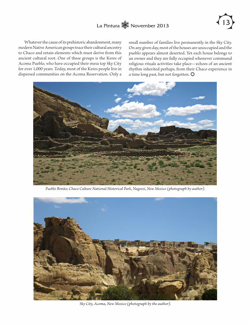
Whatever the cause of its prehistoric abandonment, many modern Native American groups trace their cultural ancestry to Chaco and retain elements which must derive from this ancient cultural root. One of these groups is the Keres of Acoma Pueblo, who have occupied their mesa top Sky City for over 1,000 years. Today, most of the Keres people live in dispersed communities on the Acoma Reservation. Only a
Pueblo Bonito, Chaco Culture National Historical Park, Nageezi, New Mexico (photograph by author).
Sky City, Acoma, New Mexico (photograph by the author).
small number of families live permanently in the Sky City. On any given day, most of the houses are unoccupied and the pueblo appears almost deserted. Yet each house belongs to an owner and they are fully occupied whenever communal religious rituals activities take place—echoes of an ancient rhythm inherited perhaps, from their Chaco experience in a time long past, but not forgotten.

14 La Pintura November 2013
ARARA AddressesARARA has several addresses. To get the most timely response, please send your inquiry to the right place.
MembershipFor all Membership matters, including new and renewal memberships (see full membership information on inside back cover), replacement of undelivered issues of La Pintura, and corrections or changes in membership information and addresses, contact:
ARARA MembershipDonna Yoder2533 W. Calle GenovaTucson, AZ [email protected]
La Pintura Editorial MattersFor editorial matters relating to La Pintura, including letters and articles for publication (see guidelines on inside back cover), preferred contact is by e-mail:
William Breen Murray, [email protected]
Postal mail for the La Pintura Editor may be sent to:
ARARAAttn: Editor, La Pintura3711 W. Deer Valley Rd.Glendale, AZ 85308-2038
For matters regarding production of La Pintura, con-tact:
Amy Gilreath Far Western Anthropological Research Group, Inc. 2727 Del Rio Place, Suite ADavis, California 95618 [email protected]
Archive, Library, Book OrdersFor information on the ARARA Archive, Library, and publications available for sale, contact:
ARARA Archive3711 W. Deer Valley Rd.Glendale, AZ 85308-2038(623) [email protected]
La Pintura is the official newsletter of the American Rock Art Research Association. Subscription to this publication is a benefit of membership in ARARA. Back issues of La Pintura are available electronically on the ARARA website, http://www.arara.org.
International Newsletter on Rock Art
INORA — The International Newsletter on Rock Art, edited by Jean Clottes and published in French and English three times a year (February, June, November) — is available to ARARA members for $25 a year. Subscribe through ARARA and save the $10 French bank charge. The 32-page newsletter contains the latest international rock art news. To subscribe, send a check for $25 made out to ARARA to:
Donna Gillette1147 Vaquero WayNipomo, CA [email protected]
Call for Papersfor La Pintura
ARARA members would love to read about your new rock art discovery, recording project, or new idea for interpretation. La Pintura needs members to submit articles on current research or fieldwork. Doing so will make La Pintura a better journal. Editorial guidelines can be found on the inside back cover of every issue.
Editorial Deadlines for La PinturaTo insure timely publication of each issue of La Pintura, please follow the following schedule of deadlines for all editorial copy and other submissions:
2014 Issue 1: December 15, 20132014 Issue 2: March 15, 2014
2014 Issue 3: June 15, 20142014 Issue 4: September 15, 2014
2015 Issue 1: January 15, 2015
Send all materials for inclusion in La Pintura to: William Breen Murray, Editor

15November 2013La Pintura
ARARA Code of EthicsThe American Rock Art Research Association subscribes to the following Code of Ethics and enjoins its members, as a condition of membership, to abide by the standards of conduct stated herein.1. All local, state, and national antiquities laws will be strictly adhered to by the membership of ARARA. Rock art research shall be subject to appropriate regulations and property access requirements.2. All rock art recording shall be non-destructive with regard to the rock art itself and the associated archaeological remains which may be present. No artifacts shall be collected unless the work is done as part of a legally constituted program of archaeological survey or excavation.3. No excavation shall be conducted unless the work is done as part of a legally constituted excavation project. Removal of soil shall not be undertaken for the sole purpose of exposing sub-surface rock art.4. Potentially destructive recording and research procedures shall be undertaken only after careful consideration of any potential damage to the rock art site.5. Using the name of the American Rock Art Research Association, the initials of ARARA, and/or the logos adopted by the Association and the identification of an individual as a member of ARARA are allowed only in conjunction with rock art projects undertaken in full accordance with accepted professional archaeological standards. The name ARARA may not be used for commercial purposes. While members may use their affiliation with ARARA for identification purposes, research projects may not be represented as having the sponsorship of ARARA without express approval of the Executive Committee.The ARARA Code of Ethics, points 1 through 5, was adopted at the annual business meeting on May 24, 1987. The Code of Ethics was amended with the addition of the opening paragraph at the annual business meeting, May 28, 1988.
ARARA Officers & Boarde-mail: [email protected]
President Ron Smith Vice-President Diane Hamann Secretary Jennifer Huang Treasurer Garry Gillette Conference Planner Donna Gillette Board Members Ann Brierty Chris Gralapp Jim Keyser Scott Seibel
La Pintura is published by the American Rock Art Research Association. All Editorial material for La Pintura should be sent via e-mail to the Editor, William Breen Murray, at [email protected]. Opinions expressed in signed articles are those of the authors and do not necessar-ily represent the views of the American Rock Art Research Association. La Pintura solicits articles, news, letters to the editor, and other items of interest to its readers. Please observe the following criteria for all manuscripts submitted. Letter to the Editor: No special format necessary. News Items: Please indicate all pertinent information such as the event, time, place, cost (if any), group or person in charge, who to contact, addresses, and deadlines. Rock Art current events and news items of interest to our members that need public notice prior to the next issue of La Pintura should be sent to ARARA’s monthly electronic newsletter “ARARA Online.” Contact Amy Gilreath at [email protected]. Articles: Manuscripts of original research are always welcome. They should embrace sound principles of investigation and present data in a clear and concise manner. Consult American Antiquity for body copy, notes, literature citations, and the proper format for References Cited. Articles are subject to editing for length. Please submit all materials intended for publication via e-mail ([email protected]). Please include author’s name, title or profes-sion, affiliation, city, state, and return e-mail address. Send illustrations as e-mail attachments. Submit line drawings as 1200dpi bitmap .tif files and black-and-white or color photographs as 300dpi high-quality-level .jpg images. Materials that cannot be e-mailed may be sent to the mailing address: ARARA, Attn: Amy Gilreath, Far Western, 2727 Del Rio Place, Suite A, Davis, CA 95618.
http://www.arara.org
The American Rock Art Research Association is a non-profit organization dedicated to encour-age and to advance research in the field of rock art. Association members work for the protec-tion and preservation of rock art sites through cooperative action with private landowners and appropriate state and federal agencies. The Association strives to promote non-destructive utilization of rock art for scientific, educational, and artistic purposes. This is ac-complished through a wide-ranging program to inform and educate the members as well as the general public regarding the rock art heritage of the United States as well as world-wide. These goals are comunicated through the quarterly newsletter, La Pintura. Annual
three-day conferences give both members and others interested in rock art the opportunity to share professional papers, slide presentations, and informal discussions. Membership in the American Rock Art Research Association is open to all with an active interest in research, non-destructive use, and preservation of rock art, regardless of their nationality or country of residence. Membership fees are: Donor $120.00 Family $50.00 Individual $45.00 Society/Institution $60.00 Student $35.00
*Student rate requires photocopy of current student ID. Foreign members please add $5.00 for Canada/Mexico, $10 for other countries.
Membership runs from January 1 through December 31 of each year. The Association is concerned primarily with American rock art, but membership is international in scope. Benefits include La Pintura, one copy of American Indian Rock Art for the year, reduced conference fees, and current news in the field of rock art. More importantly, membership means a shared concern for the ongoing conservation and preservation of one of the most significant elements of our heritage. Send member-ships to: ARARA Membership Donna Yoder 2533 W. Calle Genova Tucson, AZ 85745-2526 e-mail: [email protected]
Dated Material
La Pintura is the Official Newsletter of the American Rock Art Research AssociationAddress all editorial materials via e-mail to William Breen Murray, Editor, at [email protected] mailing address is: ARARA, Attn: La Pintura, 3711 W. Deer Valley Rd., Glendale, AZ 85308-2038
La Pintura American Rock Art Research Association8153 Cinderella PlaceLemon Grove, CA 91945-3000
First Class MailAddress Service Requested
Volume 39, Number 4
In This Issue...1 ARARA 2014 Conference2 Publication Deadline for AIRA Vol. 41, Rock Springs2 Rock Art Quilt Auctioned for SHUMLA3 Seeking a Silver Lining: Rock Art and U.S. World Heritage Sites6 IFRAO Secures Protection of Dampier Monument8 Rock Art Bookshelf > Kimberley Rock Art by Mike Donaldson, Three Volumes > Rock Art Glossary by Robert G. Bednarik et al. > Reassessment Red Linear Pictographs Article by Carolyn E. Boyd et al.12 The Chaco Experience