melbourne planning scheme · heritage precincts policy of the melbourne planning scheme. this...
TRANSCRIPT

MELBOURNE PLANNING SCHEME
TABLE OF CONTENTS
Introduction 4
1 The City of Melbourne 5
Background History 5 City of Melbourne Summary Statement of Significance 11
2. Carlton Heritage Precinct 13
Background History 13 Statement of Significance for Carlton Heritage Precinct 16
3. East Melbourne Heritage Precinct including Jolimont and the Parliamentary Precinct 19
Background History 19 0 Statement of Significance for East Melbourne Heritage Precinct including Jolimont and the Parliamentary Precinct 22
4. Kensington & Flour Milling Heritage Precinct 27
Background History 27 Statement of Significance for Kensington & Flour Milling Heritage Precinct 29
5. North & West Melbourne Heritage Precinct 31
Background History 31 Statement of Significance for North & West Melbourne Heritage Precinct 34
6. Parkville Heritage Precinct 37
Background History
37 Statement of Significance for Perky'Ile Heritage Precinct
40
7. South Yarra Heritage Precinct 43
Background History
43 Statement of Significance for South Yarra Heritage Precinct
46
8. Bank Place Heritage Precinct 50
Background History 50 Statement of Significance for Bank Place Heritage Precinct 52
9. Bourke Hill Heritage Precinct 54
Background History 54 Statement of Significance for Bourke Hill Heritage Precinct 56
10. Collins Street East Heritage Precinct59
Background History 59 Statement of Significance for Collins Street East Heritage Precinct 61
REFERENCE DOCUMENT - PAGE 2 OF 94

MELBOURNE PLANNING SCHEME
11. Flinders Lane Heritage Precinct 64
Background History 64 Statement of Significance for Flinders Lane Heritage Precinct 65
12. Flinders Street Heritage Precinct 68
Background History 68 Statement of Significance for Flinders Street Heritage Precinct 69
13. Guildford Lane Heritage Precinct 72
Background History
72 Statement of Significance for Guildford Lane Heritage Precinct
73
14. Hardware Street Heritage Precinct 75
Background History 75 Statement of Significance for Hardware Street Heritage Precinct 76
15. Little Bourke Street Heritage Precinct 78
Background History 78 Statement of Significance for Little Bourke Street Heritage Precinct 79
16. Queen Victoria Market Heritage Precinct 81
Background History
81 Statement of Significance Queen Victoria Market Heritage Precinct
83
17. Retail Core Heritage Precinct 86
Background History 86 Statement of Significance for Retail Core Heritage Precinct 88
References and Sources 91
REFERENCE DOCUMENT - PAGE 3 OF 94

MELBOURNE PLANNING SCHEME
Introduction
This document presents background materials on the history and significance of Melbourne and its Heritage Precincts. It is a reference document to Clause 22.06 Heritage Precincts Policy of the Melbourne Planning Scheme. This document provides background information to assist in understanding the context within which Clause 22.06 is framed and substantiates decision guidelines in this policy.
Included are Background History and Statement of Significance for each heritage precinct listed in the Melbourne Planning Scheme.
The Background History is a summary of the historical development of each precinct.
The Statement of Significance explains what is important about these heritage precincts. It states what is significant, how it is significant and why it is significant.
The significance assessment process culminates in a summary Statement of Significance which succinctly explains the values of each precinct. The summary Statement of Significance is replicated in Clause 22.06 Heritage Precincts Policy. The Statement of Significance establishes significance and justifies the application of the heritage overlay.
This document presents revised and restructured content from the Heritage Precincts Project study reports prepared by heritage consultant and City of Melbourne heritage advisor Meredith Gould Architects Pty Ltd dated December 2004.
REFERENCE DOCUMENT - PAGE 4 OF 94

MELBOURNE PLANNING SCHEME
1 The City of Melbourne
Background History
The framework for Melbourne is significant as the foundation for the subsequent fon -n and development of the city.
The Site for Melbourne The selection of the site of Melbourne was the result of several environmental and practical factors. Batman and Fawkner had already selected the site for the town, on elevated land and at the head of the navigable portion of the river. The location at the 'pool' below 'The Falls' near Queen Street provided a place for turning and mooring ships; up stream the water was fresh. Downstream of Batman's hill and on the south bank, the land was swampy. The hills were also thinly wooded and so afforded pasture for the first wave of livestock. The aesthetic character of the landscape, nestled between the eastern and western hills, with gentle slopes and a pleasant outlook should not be discounted as an influence on the choice of the site. Batman's Hill (in the west) was also known as 'Pleasant Hill', and the accounts of early settlers invariably refer to the visual characteristics of the area.
The City Grid and the Survey for Victoria Late in 1836, following the private settlement by Batman and Fawkner in August 1835, the Sydney authorities sent Captain William Lonsdale to act as police magistrate in the new settlement. For convenience he established himself near the settlers. In 1837 Governor Bourke arrived with surveyor Hoddle to inspect the settlement. Bourke directed the layout of town allotments at Williamstown and Melbourne, pointing out to Hoddle the approximate line of the survey. At Melbourne, this continued the site already selected by Batman and Fawkner. However, the government ignored the 'improvements' made by the private settlers and set about a new survey which would put into place planning principles for new settlements which had evolved over 50 years'. These were:
• Designation of a 'Town Reserve' of 3 miles by 1 mile, inside which allotments for sale were small and some allotments were reserved for future development.
• Placement of the 'Town reserve' on a river. • Allocation of allotments for public buildings and institutions. • A grid form adapted to suit the topography, with blocks of 10 chains by 10
chains and streets of 1.5 chains. (The Darling Regulations) • Conditions on the sale of land that would facilitate substantial construction
techniques. • Outside the 'Town Reserve', narrow frontages to allotments facing the river
or sea, to enable water access for many sites. • A rural survey grid of 1 mile by 1 mile on a cardinal alignment - magnetic
north-south and east-west.
When surveyors Russell and Hoddle were given the task of preparing the ground for a formal settlement they modified the Darling regulations to accommodate the topography, sea access and a fresh water supply. The grid was foreshortened to fit between Batman's Hill and Eastern Hill, and the alignment substantially skewed from the magnetic cardinal points to align with the course of the north bank of the river, before it turned south up upstream. This gave maximum access to the river frontage within the grid. The 'pool' below the falls, where the river widened and made an ideal turning basin; and the relatively
1 Ibid..
REFERENCE DOCUMENT - PAGE 5 OF 94

MELBOURNE PLANNING SCHEME
flat valley between the eastern and western hills, became the centre point of the town layout. Commercial and civic activities developed here.
When Hoddle positioned the 1837 Melbourne Town Reserve on the north of the river, he was accommodating a skewed city grid, already generally positioned to give maximum access to the river frontage by surveyor Russell. Hoddle was bound by the Darling Rules to make a 3 mile by 1 mile Town Reserve, in which only small allotments were released for shops, houses etc, leaving space for town expansion. Batman's Hill was an expedient position from which to mark the Town Reserve. Extending magnetic north one mile from here, just captured the skewed grid within the Town Reserve. With Hoddle's delineation two miles east and one mile west, the grid was centrally placed in the Town Reserve, and an equal quantity of land was left for expansion to the east and west 2 .
Elizabeth Street, at the bottom of the valley became the channel for commerce (with the public purpose reserves provided in the initial survey and the first permanent Post Office building open for business in 1841), while Swanston Street became the civic spine with reserves eventually being occupied by the State Library, Melbourne Hospital (later Queen Victoria Hospital) and the Town Hall. The council originally met in the Mechanics Institute in the 1840s with the present site selected in 1847, and the first permanent Town Hall building erected in 1851-3.
The port at the western end, where all the immigrants arrived and all the goods into and out of the settlements were landed, determined that the western end of the city would develop as the mercantile and warehouse area. The elevated east, a healthy distance from the noxious activities which quickly located downstream of the port, would develop as a residential and later professional area; and the centre with its flat land neatly placed between the 'supply' of goods in the west and the 'demand' from the population in the east, would become the retail and banking core. The prime sites were close to the river and development concentrated there. Lonsdale and Latrobe Street were sufficiently distant from it, to be left with the less desirable fringe development of mixed factories and artisans residences.
Lonsdale took over Batman's hill (including Batman's home and other buildings) for Government offices. The first reserve for government buildings was nearby on the site of the present law courts on William and Lonsdale Streets. North of this further government reserves later provided for the Titles Office, Registry Office, Mint and other services. Charles La Trobe, arriving in 1839 to be Superintendent of the Port Phillip district, would later direct a change to the east.
Swampy ground conditions downstream and the position of the Falls determined the bridge river crossing at Swanston Street where the rickety `Balbirnie's bridge' replaced the even more unstable punt, and was itself superseded by Lennox's stone bridge in 1846 and eventually the current Princes Bridge. This determined the southern approach that became St. Kilda Road.
Melbourne naturally drained to the west of the City. The previously beautiful natural swamp to the west of Batman's Hill, quickly became a fetid wastelands under European development. By the early 1840s the west had become the site of noxious industry, boiling down works, abattoirs, brickworks and rubbish tips, and would soon be the inevitable location for the docks and railways. Residential use moved as far away as possible. The hill to the east became the preferred residential location, setting the trend for the development of the salubrious suburbs beyond the grid to the east. - So did the government. La Trobe ensured that the Parliament, the Treasury and the Government officers would occupy the
2 Surveyors Board Victoria, Sun/eying Victoria, In Celebration of 150 years of Victoria's Surveyor General 1851— 2001, 2002
REFERENCE DOCUMENT - PAGE 6 OF 94

MELBOURNE PLANNING SCHEME
Eastern Hill. He had directed impressive buildings to be constructed here, terminating two major streets.
By 1854, the pattern of land use had set the trend for the development of metropolitan Melbourne for the next 150 years. - industry to the west, government and the best residential areas to the east, and retail at the centre.
The First Town Reserve of 1837 and the 1840s Extended Town Reserve The first town reserve of 1837 is the principal determinant of the form of the centre of Melbourne. It was bounded by the river, Victoria Street and Hoddle Street. The latter were the commencement of Hoddle's north-south and east west cardinal survey lines for the State. Within the Town Survey, land in the grid was sold over several auction dates. Here, the allotments were intended to be an appropriate size for a house or business. Around the grid, and within the reserve, there were portions of land not surveyed for sale. Outside the first town reserve, some large river allotments were surveyed in long strips giving many holders access to the river; and in Collingwood, Fitzroy and Richmond, close to the grid but outside the town reserve, large allotments were sold in 1838-9.
Very soon after the first sales in Collingwood, Fitzroy and Richmond, the government could see that the unrestrained development and the subdivision and redivision which eventuated were undesirable. An extension to the area where town allotments would be controlled by the government was required. In 1840, the parishes of North Melbourne, north to Park Street and South Melbourne, south to the bay, were formed. The slow and orderly determination of appropriate development within this much larger area would have a profound effect on the form of Melbourne's suburbs.
In 1837 at the time of the first land sales, the population of Melbourne was around 800. Jr 1839 when La Trobe arrived it was 3,511, but by the end of 1841 it was 20,416. Expansion of Town allotments was needed to accommodate the growing community. The grid could not be readily extended to the east where Collingwood and Fitzroy had been sold for "cultivation allotments" in 1837, outside the Town Reserve. Noddle had surveyed the land to the south in South Yan-a in 1839 but development was severely restricted here by the lack of a suitable bridge crossing and never preceded. Extension of the grid to the west was impractical due to the swampy land, leaving only the north and the northwest as reasonably large areas suitable for development within the Town Reserve. The Town Reserve was extended to the alignment of Brunswick Road to the north in 1840s. It was not until the 1850s that substantial areas of land were released from the 1837 Town Reserve outside the grid at East Melbourne; and in the North parish, lands within the extended Town Reserve at Carlton and North Melbourne. In these ten or so years, the balance of parks and suburban development to ring the grid would be set, largely determining the character of inner Melbourne at Carlton, North and West Melbourne, Parkville, East Melbourne and parts of South Yarra.
REFERENCE DOCUMENT - PAGE 7 OF 94

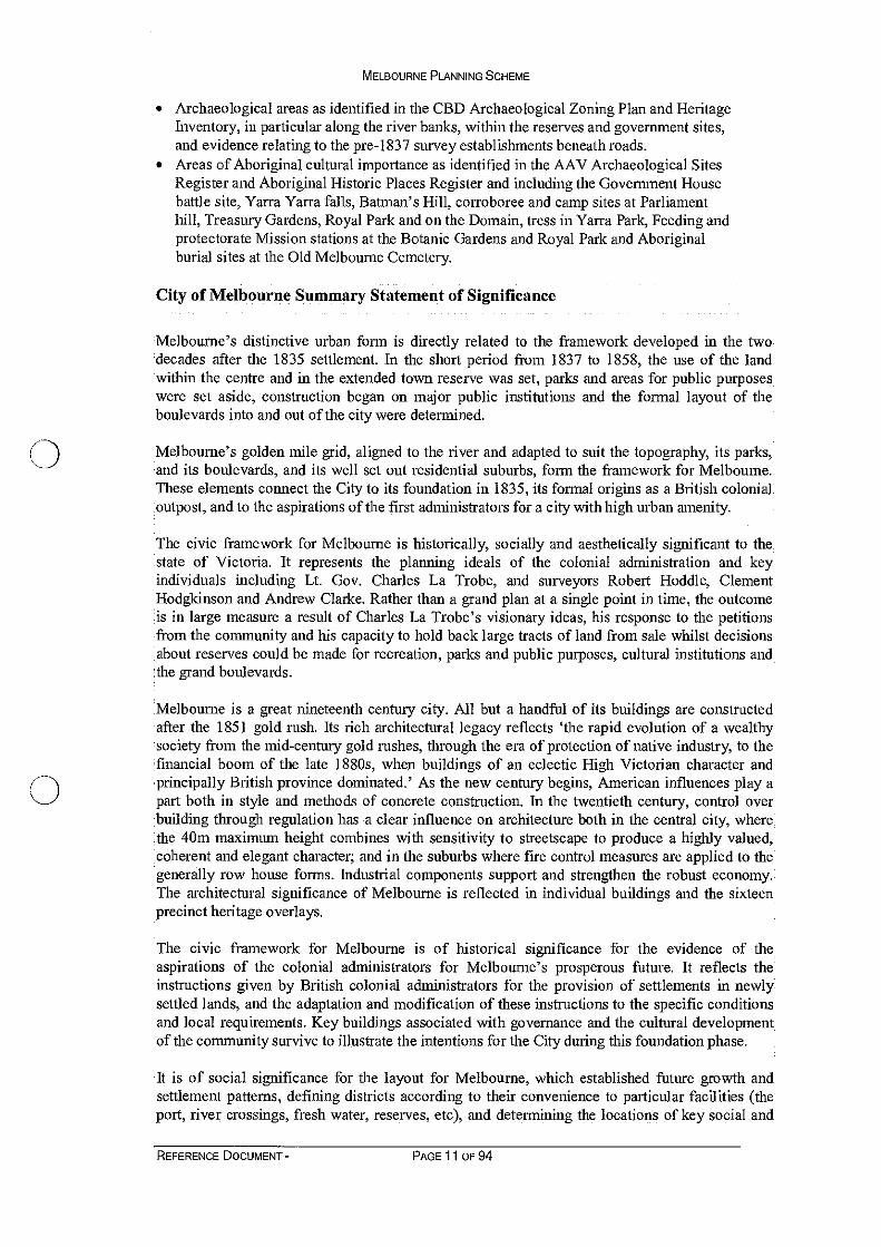
HrlArt Pla. of flellwana Anterean lierd Plea STP
L TO1 POE el V.cional (*amp* I roe Urals W...
1 ,2
MEJ.Bol'iTNE
MELBOURNE PLANNING SCHEME
Figure 2 Part of Melbourne 1837, Robert Hoddle. Note the alignment of the grid with the river, and the magnetic north alignment of the Town Reserve (marked 'Government Reserve') with Batman 's Hill as the measuring point for its boundaries one mile to the north, two miles to the east and one mile to the west. The northern boundary became Victoria Parade, Hoddle Street to the east (not shown), the Yarra to the south, and an arbitrary line in the swamp to the west. From Surveying Victoria, In Celebration of 150 years of Victoria's Surveyor General 1851 — 2001
Charles La Trobe and the Boulevards, Reserves and Parks At the direction of Governor Bourke, Superintendent Charles J. La Trobe came to Melbourne from Britain in 1839 to govern the fledgling community. He would have a lasting effect on the physical form of Melbourne. La Trobe presided for the whole of the period when land was withheld from sale between 1841 and 1852. By setting aside very large areas for parklands, public purposes, and recreation, he was largely responsible for the appearance of Melbourne today. All the suburban areas which were eventually released would be bounded by parks — North Melbourne by Royal Park; East Melbourne by the Fitzroy Gardens and Yarra Park; Carlton by Princes Park and Carlton Gardens, and retrospectively South Yarra by the Domain and the Royal Botanic Gardens. Parkville, released long after La Trobe had departed, follows the same principle of residential land in a park setting.
The early land routes towards Melbourne were determined by the communication to Sydney and squatting runs in the early years of settlement. By 1837 tracks ran south through the scrub to Sandridge and down to the Mornington Peninsula, north in line with Sydney Road, north-west to cross the Maribrynong and on to Geelong, and northeast to the Yarra valley. Subsequent surveys accommodated these tracks and as land was sold around them beyond the Town Reserve, formalised the routes to specific roads, becoming The Macedon Road, Sydney Road, Bridge Road, Heidelberg Road and Brighton Road. Between the Town blocks and suburban lands, the expanded Town Reserve provided space for appropriate
REFERENCE DOCUMENT - PAGE 8 OF 94

MELBOURNE PLANNING SCHEME
positioning of their connection to the city. These linking thoroughfares became impressive boulevards.
The placement of major entrances to the city were an integral part of the controlled planning within the expanded Town Reserve. Here, with all the land in the control of the government, it was possible for exceedingly wide boulevards to be formed. Hoddle had defined the position and enormous size of the eastern entry at Wellington Parade in the development of his 1837 plan. Hoddle also appears to be responsible for Victoria Parade and Hoddle Street in the East Melbourne section. La Trobe appears to have set the position for the roads to north west for Flemington Road (a formalised track), its extension in to the first Town Reserve giving access to the commercial and retail core in Elizabeth Street through Elizabeth Street North and to the docks via Peel Street; Royal Parade to the north, connecting the city with the Sydney Road; and St Kilda Road to the south, terminating at the gateway to the city across Princes bridge. At the turn of the twentieth century, some fifty years after La Trobe left, the Alexandra Avenue was created as a picturesque entry to the city from the east.
The ring of parks and reserves and the major boulevards that run through them and link with the city, define Melbourne's sense of place. Whilst problems reconciling the cost of maintenance with the practical demands of the colony prevented La Trobe's grand intentions from full realisation, his intention to create high quality living conditions and a city surrounded by parkland has prevailed.
The major parks and reserves set aside or reserved during this time include: The Royal Botanic Gardens The Domain including the Government House Reserve. Parliament House Reserve including the Treasury Gardens, Gordon Square and the Parliament Gardens Fitzroy Gardens — Yarra Park, including the areas now known as Olympic Park and Flinders Park
• Royal Park, Princes Park and the Melbourne General Cemetery • Carlton Gardens • Flagstaff Gardens • Fawkner Park • Albert Park (Not in the City of Melbourne) • Studley Park (Not in the City of Melbourne) • Batman's Hill was permanently reserved ml 850 but following the eventual
selection of the south of the river for the Botanic Gardens, this area eventually became the inevitable site for the railways and the docks.
Subdivision outside the central grid Many small parks were included in the residential subdivisions. In part these show the hand of the surveyors Hoddle, Clarke and Hodgkinson. Clarke's ambitious crescents and parks were not generally implemented however. In summary, in South Yarra the 1840 government cultivation allotments sold in 1846 and 1849, were subsequently subdivided privately in fits and starts. East Melbourne was subdivided in the 1840s but not released until 1852. In the north, land was subdivided and part released for sale in 1852 and 1855 in North Melbourne. Small parks were integral to development in Carlton, where land released in 1852, 1858 and the early 1860s. A very small portion of land in West Parkville near the crossing to Moonee Ponds Creek was released before 1855, but the majority of Parkville's developed area was subdivided in 1868 from the old market sites. In 1875 subdivision in North Parkville and in Gatehouse Street was extracted from the park to raise funds for the government. At a similar time the land set between Fawkner Park and Albert Park along St Kilda Road in South Yarra, was sold in large allotments. Kensington was not subdivided until the 1880s.
REFERENCE DOCUMENT - PAGE 9 OF 94

MELBOURNE PLANNING SCHEME
By the turn of the twentieth century, Melbourne became the "quintessential expression of early nineteenth century planning" 3 . Its grid, boulevards, parks and contemporary public buildings survive to illustrate the city's early planning and development. Provision of Public Buildings and Institutions in the key period La Trobe ensured that a policy of provision of land for public buildings and institutions was carried out in Melbourne. There was generous provision for churches across a broad range of denominations, but also provision for secular education. This included the National School, the very large allocation of land in a park setting for the University of Melbourne in 1853, with construction of buildings from 1854 — 1857, the Public (State) Library with construction in the mid 1850s, establishment of the Observatory in the Domain and an Herbarium. Government building proceeded apace in the 1850s with the commencement of construction of the impressive Parliament House, the Treasury, and the Government Offices in the new reservation at Eastern Hill. Defence of the Colony was also considered with Victoria Barracks commenced in 1854. The Customs House was replaced (at the same location) in 1856, the Melbourne Hospital extended and works continued at the Melbourne Goal.
Buildings Refer to Background History and the Significance Assessment and Statements of Significance for the sixteen heritage overlays.
Key Components The key components (not in rank order) in the framework for Melbourne include: • The sixteen Precincts covered by Heritage Overlay • All the main streets of the CBD golden mile including: running north south - Spencer,
King, William, Queen, Elizabeth, Russell, Exhibition and Spring Streets; running east west - Flinders, Collins, Bourke, Lonsdale and Latrobe Streets; and Market Street -the break in the grid defining the importance of the port/customs location on the bank of the river.
• The east-west little streets of the CBD golden mile, including Flinders Lane, Little Collins, Little Bourke, and Little Lonsdale Streets
• The main boulevards radiating to the north west, north, east and south being Flemington Road, Royal Parade and its extension as Elizabeth Street north, Peel Street, Victoria Parade, Wellington Parade and St. Kilda Road; and the boulevard on the east boundary at Hoddle Street in East Melbourne.
• All the Park reserves which ring the CBD - Royal Park, Princes Park (including Melbourne General Cemetery), Carlton Gardens, Fitzroy Gardens, Treasury Gardens, Parliament Gardens, Gordon Reserve, Yarra Park (including Olympic Park, the Domain (including the Government House reserve, Alexandra Gardens, Queen Victoria Gardens), Royal Botanic Gardens, and Fawkner Park); the smaller parks within the residential subdivisions; and the parks within the city including the Flagstaff Gardens.
• The Yarra River, from Swan Street to the Charles Grimes Bridge including Princes Bridge, the 'Pool' (the natural turning basin for small ships, below the rocky ledge -The Falls - which separated the fresh and salty water, situated near the end of Queen Street), Batman Park and the remaining docks and wharves on the north and south banks.
• The government and public buildings positioned on the grid and boulevards including: the site of the first government area, now containing the Mint, Births, deaths and Marriages Registry, the Titles Office and the Law Courts; the Customs House which defines the first port; the Parliament, government and Treasury buildings, Victoria Barracks, Old Melbourne Goal, the Post Office, Melbourne Town HaIl, the State Library, the Melbourne University Reserve including the 1854-7 University buildings and Moonee Ponds Creek bridge at Flemington Road and Princes Bridge..
3 Lewis op.Cit.
REFERENCE DOCUMENT - PAGE 10 OF 94
MELBOURNE PLANNING SCHEME
• Archaeological areas as identified in the CBD Archaeological Zoning Plan and Heritage Inventory, in particular along the river banks, within the reserves and government sites, and evidence relating to the pre-1837 survey establishments beneath roads.
• Areas of Aboriginal cultural importance as identified in the AAV Archaeological Sites Register and Aboriginal Historic Places Register and including the Government House battle site, Yarra Yana falls, Batman's Hill, corroboree and camp sites at Parliament hill, Treasury Gardens, Royal Park and on the Domain, tress in Yarra Park, Feeding and protectorate Mission stations at the Botanic Gardens and Royal Park and Aboriginal burial sites at the Old Melbourne Cemetery.
City of Melbourne Summary Statement of Significance
Melbourne's distinctive urban form is directly related to the framework developed in the two decades after the 1835 settlement. In the short period from 1837 to 1858, the use of the land within the centre and in the extended town reserve was set, parks and areas for public purposes were set aside, construction began on major public institutions and the formal layout of the boulevards into and out of the city were determined.
Melbourne's golden mile grid, aligned to the river and adapted to suit the topography, its parks, and its boulevards, and its well set out residential suburbs, form the framework for Melbourne. These elements connect the City to its foundation in 1835, its formal origins as a British colonial outpost, and to the aspirations of the first administrators for a city with high urban amenity.
The civic framework for Melbourne is historically, socially and aesthetically significant to the state of Victoria. It represents the planning ideals of the colonial administration and key individuals including Lt. Gov. Charles La Trobe, and surveyors Robert Hoddle, Clement Hodgkinson and Andrew Clarke. Rather than a grand plan at a single point in time, the outcome is in large measure a result of Charles La Trobe's visionary ideas, his response to the petitions from the community and his capacity to hold back large tracts of land from sale whilst decisions about reserves could be made for recreation, parks and public purposes, cultural institutions and the grand boulevards.
Melbourne is a great nineteenth century city. All but a handful of its buildings are constructed after the 1851 gold rush. Its rich architectural legacy reflects 'the rapid evolution of a wealthy society from the mid-century gold rushes, through the era of protection of native industry, to the financial boom of the late 1880s, when buildings of an eclectic High Victorian character and principally British province dominated.' As the new century begins, American influences play a part both in style and methods of concrete construction. In the twentieth century, control over building through regulation has a clear influence on architecture both in the central city, where the 40m maximum height combines with sensitivity to streetscape to produce a highly valued, coherent and elegant character; and in the suburbs where fire control measures are applied to the generally row house forms. Industrial components support and strengthen the robust economy. The architectural significance of Melbourne is reflected in individual buildings and the sixteen precinct heritage overlays.
•The civic framework for Melbourne is of historical significance for the evidence of the aspirations of the colonial administrators for Melbourne's prosperous future. It reflects the instructions given by British colonial administrators for the provision of settlements in newly settled lands, and the adaptation and modification of these instructions to the specific conditions and local requirements. Key buildings associated with governance and the cultural development •of the community survive to illustrate the intentions for the City during this foundation phase.
It is of social significance for the layout for Melbourne, which established future growth and settlement patterns, defining districts according to their convenience to particular facilities (the port, river crossings, fresh water, reserves, etc), and determining the locations of key social and
REFERENCE DOCUMENT - PAGE 11 OF 94

MELBOURNE PLANNING SCHEME
economic institutions such as the commercial hub, industry, the parliamentary, civic and religious precincts, markets, and transport areas.
It is of aesthetic significance for its architecture, the variety of distinctive views, vistas and the visual character of the urban form, including important terminal vistas (consciously planned by governor La Trobe), towards Parliament House — Bourke Street, the Treasury — Collins Street; and city edge views — Flinders Street and Spring Street; the grand processional entrances from the historically important travel routes into the city; and for the parkland which (almost) surrounds the grid and defines the borders of the residential precincts.
Melbourne is of scientific significance for its botanical collection and in particular for the avenues of Ulmus procera, now rare on a world scale.
The key components in the Framework for Melbourne include:
• The sixteen Precincts covered by Heritage Overlay • All the main streets of the CBD golden mile including: running north south -
Spencer, King, William, Queen, Elizabeth, Russell, Exhibition and Spring Streets; running east west - Flinders, Collins, Bourke, Lonsdale and Latrobe Streets; and Market Street -the break in the grid defining the importance of the port/customs location on the bank of the river.
• The east-west little streets of the CBD golden mile, including Flinders Lane, Little Collins, Little Bourke, and Little Lonsdale Streets The main boulevards radiating to the north .west, north, east and south being Flemington Road, Royal Parade and its extension as Elizabeth Street north, Peel Street, Victoria Parade, Wellington Parade and St. Kilda Road; and the boulevard on the east boundary at Hoddle Street in East Melbourne.
• All the Park reserves which ring the CBD - Royal Park, Princes Park (including Melbourne General Cemetery), Carlton Gardens, Fitzroy Gardens, Treasury Gardens, Parliament Gardens, Gordon Reserve, Yarra Park (including Olympic Park, the Domain (including the Government House reserve, Alexandra Gardens, Queen Victoria Gardens), Royal Botanic Gardens, and Fawkner Park); the smaller parks within the residential subdivisions; and the parks within the city including the Flagstaff Gardens. The Yarra River, from Swan Street to the Charles Grimes Bridge including Princes Bridge, the 'Pool' (the natural turning basin for small ships, below the rocky ledge - The Falls - which separated the fresh and salty water, situated near the end of Queen Street), Batman Park and the remaining docks and wharves on the north and south banks. The government and public buildings positioned on the grid and boulevards including: the site of the first government area, now containing the Mint, Births, deaths and Marriages Registry, the Titles Office and the Law Courts; the Customs House which defines the first port; the Parliament, government and Treasury buildings, Victoria Barracks, Old Melbourne Goal, the Post Office, Melbourne Town Hall, the State Library, the Melbourne University Reserve including the 1854-7 University buildings and Moonee Ponds Creek bridge at Flemington Road and Princes Bridge.
• Archaeological areas as identified in the Heritage Inventory (Heritage Act 1995), in particular along the river banks, within the reserves and government sites, and evidence relating to the pre-1837 survey establishments beneath roads.
• Areas of Aboriginal cultural importance as identified in the Aboriginal Affairs Victoria Aboriginal Heritage Register and including the Government House battle site, Yarra Yarra falls, Batman's Hill, corroboree and camp sites at Parliament hill, Treasury Gardens, Royal Park and on the Domain, tress in Yarra Park, Feeding and protectorate Mission stations at the Botanic Gardens and Royal Park and Aboriginal burial sites at the Old Melbourne Cemetery.
REFERENCE DOCUMENT - PAGE 12 OF 94

MELBOURNE PLANNING SCHEME
2. Carlton Heritage Precinct
Background History
Hoddle's Plan of Melbourne of 1842 indicates "Grassy forest land principally timbered with Eucalyptus, Casuarina, Mimosa" in the region of Carlton. The region was grouped with other lands north of Victoria Street and generally referred to as "North Melbourne". Its easterly extent was "Newtown" (Fitzroy) which had been subdivided and sold in the late 1830s. Land in this region was withheld from sale following the declaration of the 1841 extended Town Reserve north of Victoria Street to Brunswick Street, pending the determination of the location of parks, sites for institutions and the major entrances to the city.
In January 1844, the Corporation of Melbourne petitioned the Governor Charles La Trobe to grant land of around 500 acres in each of two parcels, one in the vicinity of North Melbourne (in this case including what would later become Carlton) and the other in the vicinity of South Melbourne. Eventually after input from the government in N.S.W. and the Council, an area of 2560 acres north of the city was put aside for recreation and the public advantage in September 1850. Part of this land included Carlton. La Trobe asked the Council for a definite area to be laid Out and on November 4 th 1850 and, promised that he would facilitate the final determination of the approaches to the city from the north and the north-west. The broad form of the land to be assigned for Princes Park. The University of Melbourne, Carlton gardens and the Melbourne General Cemetery appears to have been determined by La Trobe after 1851 and before he left Melbourne in 1854.
Kearney's map of 1855 indicates the formation of Royal Parade, the form of The University of Melbourne, and Carlton Gardens as a large park touching the north east corner of the city grid. Subdivision of land for private development in and around these features commenced in the 1850s
The first sales of land were south of Grattan Street in 1852. Hoddle's plan for the land north of the 1837 Town Reserve beyond Victoria Street, directly connected the skewed city grid with the magnetic north alignment of the State survey, forming triangles of land at the junction of the skewed grid. HoddIe included two aligned London-square style parks to the 1852 plan, at Argyle Square and Lincoln Square, connected by the short section of Pelham Street and terminating at the Carlton Gardens. Development proceeded soon after the sales. East of Swanston Street, along the higher land in Grattan Street and around the squares, development was residential, including high quality homes. West of Swanston Street and south of Pelham Street, the mixed uses already well established in the north of the city grid, including manufacturing, industry and brewing were extended. Barry (University) Square, set aside in 1860, added to the amenity already anticipated by Hoddle's inclusion of two aligned London Style parks to the 1852 plan, at Argyle Square and Lincoln Square. Pelham Street connected all these squares terminating at the Carlton Gardens. Drummond Street also attracted high quality construction, both in early development and in through upgrades to facades in the 1870s and 1880s.
Argyle Square, with its mature elms set in grass, in formal diagonal planting, displays the 1850s style initially developed at the Fitzroy Gardens (subsequently altered to its current more serpentine form). Lincoln and Barry Squares also have important avenue and individual planting with high heritage value. Barry Square includes the formal design style exhibited at Argyle Square.
In Drummond Street, there is strong consistency in the built form. Row houses are more usually two storeys, generally include verandahs, often in the standard two storey cast iron format, with rendered masonry buildings more common although face brick is also used. Some stone buildings survive from development in the 1850s and 1860s, albeit sometimes with Victorian facades.
REFERENCE DOCUMENT - PAGE 13 OF 94

MELBOURNE PLANNING SCHEME
Parapets, often with embellishments and a concealed roof are more common than exposed pitched roofs. Front gardens are common. The row form is dominant with abutment to the side boundaries of allotments and a strong definition of the property boundary. Contributory buildings usually have the higher portion at the front of the allotment, a slightly lower rear wing behind and usually a very small rear yard with access to a rear lane, sometimes wide enough to encourage vehicle access. A few landmark residential buildings from the nineteenth century have a three-storey form; otherwise, churches, schools and public buildings are the landmark structures in an otherwise generally tall, two storey built form.
Elsewhere in the precinct there is less uniformity in the residential form. Almost all contributory buildings are of single or two storeys, have a row form and abut the side boundaries of allotments. There is strong definition of the property boundary. Contributory buildings usually have the higher portion at the front of the allotment, a slightly lower rear wing behind and usually a very small rear yard with pedestrian access to a small rear lane. Churches, schools and public buildings are the landmark structures in an otherwise low scale built form. The parks with their formal tree layouts, simple paths and grass surfaces strongly reinforce the mid-nineteenth century character of the precinct. Rathdowne Street, the Carlton Gardens and the Royal Exhibition Building dominate the precinct.
There has been considerable redevelopment in the mixed-use industrial regions and around Barry (University) Square. Allotments along Rathdowne Street facing Carlton Gardens also attracted somewhat intrusive redevelopment in the 1970s.
North of Grattan Street to Neill Street the subdivision from the early 1860s, including the small London-square style parks at Murchison and Macarthur Squares. This plan introduces a more definite 45 degrees connection with the Heidelberg Road through the purposefully wide Neill Street. Flemington Road and Sydney Road (Royal Parade) are the primary access points to Melbourne from the north and west of the state. The entrance from the east was set in the late 1830s as Wellington Parade and its continuation as Bridge Road leading to Hawthorn; but the entrance from the northeast was blocked by the early suburban division of Fitzroy. The north-eastern road to Heidelberg had to divert to Smith Street until Neill Street provided this more direct connection.
Allotments closest to the parks and the University sold first. Early buildings had a smaller scale and simpler form than the tall houses of the boom period in the 1880s. Bluestone, plentiful by the end of the 1850s and more reliable than the locally produced bricks, was sometimes used here, as was timber for the less substantial dwellings. Rapid population growth and development across Melbourne in the 1870s and 1880s saw substantial additions to some of these early structures and even new "Victorian" facades, particularly in Drummond Street. Vacant land was filled in and less substantial structures removed for new development, made more uniform by the application of the Melbourne Building Act across Carlton in 1872, after which timber construction close to the property boundary was precluded.
By the 1890s, the majority of Carlton had been developed as a residential zone, serviced by shops with attached residences in Lygon and Elgin Streets. A fine grain subdivision pattern had occurred within the crown allotments, with lanes created to service the collection of night soil, very few of which were wide enough to provide rear access for stables. Churches had been constructed, often on prominent corner sites granted by the government and the new Education Department schools serviced the residential community.
Where development soon after subdivision has survived, it shows a simpler form, and greater diversity in scale and materials within the orderly subdivision pattern. Carlton Street and the development around Murchison and Macarthur Squares illustrate this. A mixture of bluestone, face brick and rendered buildings is found here, with a few rare timber structures. Verandahs are sometimes but not always used. Front gardens occur randomly. Almost all buildings are of single or two storeys, have a row form and abut the side boundaries of allotments. There is strong
REFERENCE DOCUMENT - PAGE 14 OF 94

MELBOURNE PLANNING SCHEME
definition of the property boundary. Contributory buildings usually have the higher portion at the front of the allotment, a slightly lower rear wing behind and usually a very small rear yard with pedestrian access to a small rear lane. Churches, schools and public buildings are the landmark structures in an otherwise low scale built form. The parks, with their formal tree layouts, simple paths and grass surfaces strongly reinforce the elegant order of the precinct.
Slightly later development shows greater uniformity. Cardigan Street north of Faraday Street illustrates this. The row houses are more usually two storeys, generally include verandahs, often in the standard two storey cast iron format, with rendered masonry buildings more common although face brick is also used (note particularly Barkly Street). Stone is unlikely to be used and there are no timber structures (after 1872). Parapets, often with embellishments and a concealed roof are more common than exposed pitched roofs. Front gardens are not common, except in the north-eastern portion of the precinct, where single storey development is also more common. The row form is dominant with abutment to the side boundaries of allotments and a strong definition of the property boundary. Contributory buildings usually have the higher portion at the front of the allotment, a slightly lower rear wing behind and usually a very small rear yard with pedestrian access to a small rear lane. The shopping precincts are fine rows of typical nineteenth century shop-and-dwellings. Frequently these had verandahs over the footpath, some of which survive. A few landmark commercial buildings from the nineteenth century have a three-storey form; otherwise, churches, schools and public buildings are the landmark structures in an otherwise generally two storey built form.
The University of Melbourne, Melbourne General Cemetery and Princes Park. Princes Park was set aside by the government in the 1840s but not permanently reserved and vested in the City of Melbourne until 1864. Considerable debate about how improvements to the city parks were to be funded continued through the 1850s and 1860s. Joint management with the government as the senior partner ensued in 1873 and remained until 1917 when the City of Melbourne took over all the parks within Carlton as committee of management. Melbourne General Cemetery was set aside in 1853, to replace the then full cemetery at the current site of Victoria Market. The design and plantings, attributed to the then Director of the Botanic Gardens, Baron Ferdinand von Mueller, continued the open spaces of Princes Park and the northern portion of the University reserve.
The University of Melbourne was established by Gov. La Trobe in 1853 and building commenced in 1854. In 1866 generous portions of land were set aside for residential colleges bounding College Crescent and the land between the colleges and the University set aside for recreation. (The university oval and sports area). The university's expansion has left of legacy of many structures of cultural heritage value, set within an open landscape character. Some mature trees also survive.
Together, the Melbourne General Cemetery, The University of Melbourne. Princes Park, Royal Parade, College Crescent and Cemetery Road East and West have an open landscape form. They are an essential element in La Trobe's plan for a ring of park and public facilities around the centre of Melbourne. Carlton was fully developed by the end of the nineteenth century. Industry concentrated south of Pelham Street., west of Cardigan Street.; shopping strips in Elgin and Lygon Streets, with some institutions including churches at the city end of Lygon Street and residential uses elsewhere. Continuing development occurred in the industrial/commercial areas, particularly between the wars. However a preference for the garden suburbs in Hawthorn, Camberwell, Brighton and the like, now served by the excellent metropolitan railway, saw the residential areas of Carlton fall from favour in the early twentieth century. As a consequence there was little change to the building form until the Housing Commission sought to clear what was considered substandard housing in the 1950s. Returning to favour in the late 1960s, there has been a steady refurbishment of building stock. The quantity of reasonably intact building fabric, and contributory landscape elements and civic works remains high.
REFERENCE DOCUMENT - PAGE 15 OF 94

MELBOURNE PLANNING SCHEME
Statement of Significance for Carlton Heritage Precinct
What is significant? Archaeological sites associated with the Aboriginal community before and after European settlement up to 1860.
Carlton developed from a mid nineteenth century government subdivision, through the nineteenth and early twentieth centuries, into a town plan of generally wide principal streets with a network of lanes. Several of the major boulevards planned by Melbourne's early surveyors as entrances to the city, are included within and define the heritage place including: Royal Parade and College Crescent, Princes Park Drive, Cemetery Road West, Cemetery Road East; Victoria Street and Victoria Parade, including the street trees and road form. The town plan and boulevards are part of significance, reinforced by mature street tree avenues in Swanston Street north of Elgin Street, Royal Parade, Princes Park Drive, College Crescent, Cemetery Road East and West, Keppel Street, Grattan Street, Cardigan Street, Canning and Drummond Streets.
Landowners redivided the government allotments and constructed generally terrace-row housing and residential service buildings in the second half of the nineteenth century and the first two decades of the twentieth century. Residential buildings are generally low scale — two storey and single storey — and constructed from brick or rendered masonry, with a few early examples of stone and timber construction before 1870. The developed urban pattern for the precinct usually includes a rear wing of lower scale than at the front; a small open space at the rear often with access to a lane, definition of the property boundary with a fence, verandah or building; and either a front garden setback or construction onto the front boundary at the principal street. Front verandahs are common on houses and street verandahs are usual on retail facilities. A small number of buildings survive from the 1850s and the early 1860s._Small scale industrial redevelopment occurred in the early twentieth century but is generally limited in extent and primarily located in the small streets.
Places which contribute to significance in the Carlton Precinct include: those graded A, B, C and D; and places included on the Victorian Heritage Register which are within the primary period of significance for the precinct
Essential landscape components of the town plan are the large parks, open spaces, and the smaller parks in the London-square style including: the whole of Princes Park, Carlton Gardens, Argyle Square, Murchison Square, Macarthur Square, Barry (University) Square, Lincoln Square: and the open landscape form of the Melbourne General Cemetery, and The University of Melbourne north of Tin Alley. These areas often retain their original landscape design and also have mature tree plantings including: specimen trees; mature tree avenues; perimeter borders and garden bed borders (e.g. the rock edging to Argyle Square). There are some individually "Significant trees" within Melbourne University
Civic works, including bluestone kerb and channels and gutters, bluestone paving, asphalt roads and footpaths, sewer siphons and monuments contribute to significance.
South of Grattan Street, views to the dome of the Royal Exhibition Building and the nineteenth century context for this World Heritage Site, contribute to significance. This area is also notable for the collection of buildings using stone on the facade.
North of Grattan Street, significance also arises through the collection of early buildings east of The University of Melbourne and the small number of timber buildings predating the fire-rated construction required after adoption of the Melbourne Building Act.
REFERENCE DOCUMENT - PAGE 16 OF 94

MELBOURNE PLANNING SCHEME
How is it significant? Carlton is of historical, scientific, architectural, aesthetic and social significance to the City of Melbourne.
Why is it Significant?
Historical Significance Carlton is historically significant as a part of La Trobe's ambitious 1840s plan for a landscape focus for the physical fon -n of Melbourne. Princes Park, Carlton Gardens, the Melbourne General Cemetery and The University of Melbourne are historically significant in the development of a plan for the cultural and physical development of the City of Melbourne. The institutional sites in the triangular land parcels along Victoria Street illustrate the founding intentions for a culturally rich city and mark the intersection of the first Town Reserve and the cadastral grid for Victoria. The Royal Exhibition Building and Carlton Gardens are historically significant as the most complete nineteenth century International Exhibition site in the World.
Scientific Significance Carlton has scientific (horticultural) significance for its collection of mature plants in parks and street plantings, including avenues of Ulmus procera, now rare throughout the world.
Architectural Signcance Carlton has architectural significance for the nineteenth and early twentieth century built forms and the nineteenth century plan-form of streets, lanes and associated civic works. Some sites have additional architectural significance through their surviving 1850s and early 1860s components, which are now rare. The consistency of building type combined with high integrity has resulted in some precincts and or streetscapes of local, metropolitan or state significance, for their illustration of nineteenth and early twentieth century row housing.
The College precinct north of Tin Alley within the University of Melbourne, has outstanding architectural significance as a unique urban form, with large and impressive residential colleges set within an extensive landscape framework, reflecting their location within the ring of Melbourne Parks.
Aesthetic Significance Carlton has aesthetic significance for: the open park landforrn in a city setting; the mature avenues and individual trees in parks and some streets; the views into the parks, particularly the view from Victoria Street to the south entry of the Royal Exhibition Building; the mature tree avenues in Royal Parade, College Crescent, Cemetery Road East, Cemetery Road West, and Swanston Street (north of Elgin Street); the landscape design for the Carlton Gardens, Princes Park and the small squares; and the open treed landscape within The University of Melbourne north of Tin Alley and on the south and west of the campus.
Social Significance Carlton has social significance for its connection with several immigrant groups after World War 1. Lygon Street remains a focus for Australians of Italian background.
REFERENCE DOCUMENT - PAGE 17 OF 94

MELBOURNE PLANNING SCHEME
Carlton Heritage Precinct Summary Statement of Significance
Carlton was subdivided and sold at government auction less than twenty years after the commencement of non-Aboriginal settlement at Melbourne in 1835. It is an early part of the development of the metropolis, and an essential component of Governor La Trobe's plan for a city with high urban amenity. The University of Melbourne is an important element in the development of a plan for the cultural development of the State.
Carlton has outstanding heritage value as an element of the mid-nineteenth century plan for a high quality urban environment to encircle central Melbourne, surviving with reasonable intactness. The framework of parks, boulevards and public institutions laid down in the 1840s and 1850s played a vital role in the developing form of the metropolis and is a primary contributor to its distinctive sense of place. At Carlton this is represented by Princes Park, Carlton Gardens, Royal Parade, the Melbourne General Cemetery and The University of Melbourne. In this elegant park setting, is a planned suburb from the second half of the nineteenth century incorporating small London-square style parks and a high proportion of the pre 1900 building stock including row houses, retail, community and institutional buildings. The streetscapes have cultural heritage significance for their representation of nineteenth century inner urban development, in some instances at the State level.
Carlton is an essential component of Melbourne's historic urban form.
The principal period of development contributing to the cultural significance of Carlton is 1852 to 1920.
REFERENCE DOCUMENT - PAGE 18 OF 94

MELBOURNE PLANNING SCHEME
3. East Melbourne Heritage Precinct including Jolimont and the Parliamentary Precinct
Background History
Hoddle's Plan of Melbourne of 1837, just two years after European settlement, indicates "Grassy hill [and] forest" in the region of East Melbourne, already with a "proposed "road, through what would later become the Fitzroy Gardens, to connect with Smith Street and the Heidelberg Road. Capt. Lonsdale's "Government House" and the "Proposed Government Paddocks" adjoining are shown in the position of Yarra Park and Jolimont, with Wellington Parade departing from the south west corner of the skewed city grid, aligned to magnetic east.
Just five years later, Hoddle's 1842 plan shows Lt. Gov. La Trobe's purchase of 125 acres facing Wellington Parade next to the former "Government House" and surrounded by the proposed Government Paddock. There is a description of the Yarra Park land as "open forest honeycombed level Land with spots of Trap Rock and Stones" and north of Wellington Parade is a block plan for the survey of whole of the land, except for an area along Spring Street and a huge reservation for Victoria Parade. This plan shows a clear intention to provide some land for residential development immediately to east of the city grid early in the European settlement of Melbourne.
However a decision to proceed was hampered by the lack of a decision on the location for the seat of government. Hoddle's 1842 grid plan for East Melbourne also had topography issues. A creek traversed the site from north to south and the landform was steep on each side —hardly ideal for building development on the western side. A new subdivision plan was developed with a major park incorporated in the western sector covering the steep land on either side of the creek. This was in place by 1848, but no auctions ensued until 1852. The government did grant some land in advance of this. In 1850 Bishop Perry, who had been living on La Trobe's land in Wellington Parade, selected a large site, facing the proposed park in Clarendon Street for the Bishop's house and for the Anglican Cathedral for Melbourne. The house commenced construction soon after, but the cathedral did not eventuate, the site on the corner of Swanston and Flinders Street eventually being adopted in preference.
The government appointed missionary Langhorne recorded an Aboriginal population of around 700 in a circuit of 30 miles (48 km) around Melbourne, divided into 3 tribes — the Waworong, Bonurong and Watowrong. The Yarra River, including Yarra Park and its extensive area of associated wetlands, contained important food resources, including eels, fish and game, and supported a higher Aboriginal population than in other parts of the region which would become Melbourne.
In 1837, 895 acres of land was set aside south east of Yarra Park for an Aboriginal Mission. The reserved Mission land was bounded by the River Yarra, Punt Road, Williams Road and High Street. But this proposal was short lived. By 1839, this land had been subdivided for sale and the Mission was transferred to the west side of Punt Road, close to the south bank of the river and opposite Yarra Park. The Aboriginal mission commenced here in January 1837 but by July 1839 had also closed. Some indigenous trees — Hodclle's "open forest", which predate European settlement survive in Yarra Park.
In 1854, La Trobe left the colony with instructions to Sir Henry Palmer for his land to be subdivided. Some streets were named after La Trobe's children and the suburb was named after La Trobe's house "Jolimont". This land was close to the city, elevated above the Flinders Street ponds and surrounded by parklands. It was highly sought after. Fine buildings were constructed here, some in the 1860s and many in the 1870s. It was substantially developed by 1890. This area has similar characteristics to the development on the hill in precinct 1, with greater uniformity in
REFERENCE DOCUMENT - PAGE 19 OF 94

MELBOURNE PLANNING SCHEME
scale. The best housing occupied the perimeter streets, generally two storey in scale, and smaller housing occupied the inner streets, generally at single storey scale.
A portion of the subdivision of La Trobe's land plan was developed as the innovative Jolimont Square, with houses facing a private central park off Wellington Parade. This parcel survives at the Deaf Society site, complete with square and some early trees.
In December 1851, just after separation from New South Wales, La Trobe selected the site at the top of Bourke Street for the Legislative Assembly chamber. The development of East Melbourne could now go ahead. The government kept many sites around Eastern Hill for churches and institutions. Some of the developments on these lands survive at St Peter's, St. Patrick's, Cathedral College and the former Baptist church. In and around these, high quality houses were constructed on the large allotments. The subdivision was gracious — wide streets, a major park, and smaller London-square style parks. The site was also healthily located on high ground, was close to the seat of government and had the sanction of the Bishop. - A recipe for high quality for development. The land was released for sale into the booming economy of the gold rush market in 1852 and the allotments were eagerly sought. Residential development followed at a steady pace and was almost complete by 1890.
The most desirable areas were developed first, particularly around the parks and along the major boulevards of Wellington Parade and Victoria Parade. The Melbourne Building Act applied from the outset and as a consequence there were few timber buildings constructed. Stone was used in the 1850s and 1860s, to be replaced by face brick and render as the predominant building materials.
Some development from the 1850s and 1860s, constructed soon after subdivision, has survived, concentrated on the higher ground near Wellington Parade, Clarendon Street and Albert Street. These buildings generally reflect the high status of their site and their early date, through the provision of gardens. These early buildings have different architectural forms but are connected through their generally elegant proportions and use of stone.
The properties built along on the north of Wellington Parade in the 1850s looked south across a large expanse of Crown Land enveloping La Trobe's own parcel of 125 acres. This was largely taken up by the Richmond Police Paddock, also known as Barkly Park, and later named Yarra Park, although a portion on the north bank of the river opposite the Botanic Gardens had also been used for accommodation of animals associated with the Acclimatisation Society.
The development of East Melbourne proceeded over five decades in the nineteenth century and into the early twentieth century. High quality initial building resulted in few redeveloped sites. Buildings from different decades are interspersed across the precinct, resulting in diversity in scale and materials within the orderly subdivision pattern. Generally constant built features include the incorporation of front gardens, front verandahs sometimes but not always used and strong definition of the property boundary with a fence building or verandah. On the higher ground, most buildings are of two storeys with a few, rare three storey buildings. On the lower ground there is a mixture of single and two-storey development, again with a rare taller building. Some buildings have a row form and abut the side boundaries of allotments; others are freestanding and sit in a garden setting. Contributory buildings usually have the higher portion at the front of the allotment, a slightly lower rear wing behind and a reasonable rear yard that is relatively large for inner urban areas. Sometimes the rear yards included gardens in the nineteenth century. Most properties have access to a rear lane, often of sufficient size to permit stables. Churches, schools and public buildings are the landmark structures in an otherwise low scale built form. The parks, with their fonnal tree layouts, simple paths and grass surfaces strongly reinforce the elegant order of the precinct.
REFERENCE DOCUMENT - PAGE 20 OF 94

MELBOURNE PLANNING SCHEME
Parks are a key feature of East Melbourne. Town Clerk Fitzgibbon provided a list of parks and lands intended for ornamental purposes in Melbourne in 1856.
Royal Park, Princes Park, South Park, Batman's Hill, Canton gardens, Fitzroy Square, Flinders Street Lagoons, Richmond Police Paddock, Studley Park, Lincoln Square, Argyle Square, Victoria Parade, Wellington Parade.
Four of these are in East Melbourne — Fitzroy Square (Gardens), Richmond Police Paddock (Yarra Park), Wellington Parade and Victoria Parade. The latter are the major boulevards planned as the easterly entrances to the city. Both alignments are included on Hoddle's 1837 Plan for Melbourne and were subsequently developed with a large central park space and a road on each side. The central park in Wellington Parade appears to be developed first. The Cox Plan of Melbourne of 1860s shows plantations in Wellington Parade and centre plantations at the western end of Victoria Parade. This line cut through the Wellington Parade park and affected land on the southeast comer of the East Melbourne grid.
After some initially meagre efforts by the Council, the Fitzroy Gardens were developed by the Colonial Government, in a formal avenue design, featuring a rockery along the creek bed. It would provide an impressive setting for the parliamentary precinct and government offices. The basic plan was laid out by 1862 and much of the planting undertaken, probably to the design of Clement Hodgkinson. Improvements continued over the next three decades and major thinning was undertaken in the 1880s and 1890s. Many of the Eucalyptus species from the 1860s plantings were removed at this time. Guilfoyle instituted a more open form with decorative floral emphasis in the 1890s. The gardens were mature at their transfer to the City of Melbourne in 1917.
Darling Square is a simple cross planting of trees on a grass surface, typical of the park plantings from the 1860s. Powlett Reserve incorporated sporting facilities, which limited its plantings. It includes more exotic plantings such as palms in a character that reflects the turn of the twentieth century.
East Melbourne was substantially developed by 1890, and fully developed by the beginning of the First World War — fully residential with residential service buildings, except for the brewery in Victoria Parade and the Institutions. As for other inner city residential areas, a preference for the garden suburbs in Hawthorn, Camberwell, Brighton and the like, now served by the excellent metropolitan railway, saw the residential areas of East Melbourne fall from favour in the early twentieth century, though not to the same extent as Carlton. In the 1920s and 1930s boarding houses took over some of the larger homes and some sites were redeveloped for quite good quality flats. There was little change to the building form of houses. In the post World War 2 boom, many large blocks along Albert Street and Victoria Parade, close to the commercial hub of the city, were redeveloped for commercial use, in some cases by government. Encroachments east of the Fitzroy gardens began with the Mercy Hospital but were halted by the introduction of Urban Conservation Controls in 1983. Returning to favour as a high status residential location in the late 1960s, there has been a steady refurbishment of building stock. Many buildings have high individual significance and the quantity of intact building fabric is very high. For East Melbourne the close relationship with the Fitzroy Gardens, the small parks, and the boulevards has remained. Civic works contribute to the precinct.
East Melbourne was planned as a complete suburb in the 1840s. No other place in Melbourne provides a better example of La Trobe's intentions for a city ringed by parks and punctuated by impressive boulevards; and residential precincts with high urban amenity. East Melbourne is the most intact residential area in the City of Melbourne area from the 1850s.
Substantial portions of the contributory fabric of the place survive to enable cultural significance to be interpreted.
REFERENCE DOCUMENT- PAGE 21 0F94

MELBOURNE PLANNING SCHEME
Yarra Park was reserved and vested in the City in 1864, but further encroachments to La Trobe's ring of parklands occurred. To the east at the corner of Hoddle Street and Wellington Parade South, a portion of land similar in size to La Trobe's 125 acres, was subdivided out of the Police Paddock for housing in 1881. Development is consistent here and characterised by row houses, usually of two storeys, generally including a verandahs, often in the standard two storey cast iron format, with rendered masonry buildings more common although face brick is also used. Parapets often with embellishments and a concealed roof arid exposed pitched roofs are both used. Front gardens are common. The row form is dominant with abutment to the side boundaries of allotments and a strong definition of the property boundary. Contributory buildings usually have the higher portion at the front of the allotment, a slightly lower rear wing behind and usually a rear yard with access to a lane, wide enough for stables.
The major encroachment into Yarra Park are the private and later public railways. In 1858, the Melbourne and Suburban railway Company was granted a large portion of intended parklands at the Richmond Police Paddock and the Flinders Street Lagoons, for the construction of a terminal Station and track to the southeast. Sporting facilities had already begun their development, with 10 acres set aside for the Melbourne Cricket Ground in 1853. The track cut the park in half, its elevated form physically and visually separating the two sections. Sporting facilities developed on both sides and were the focus for the Melbourne Olympic Games in 1956. The railway again encroached in 1901 with the construction of the direct line from Princes Bridge to Clifton Hill, bypassing a large loop for the Whittlesea and Heidelberg (now Epping and Hurstbridge) lines. This line cut through the Wellington Parade park and affected land on the southeast corner of the East Melbourne grid. The rail yards grew relentlessly wider and Flinders Street Lagoons were engulfed. In 190*, the course of the river was substantially changed, by removing the meander opposite the Botanic Gardens. A large chunk of Yarra Park was cut off and became part of the river and the lagoon here became part of the Botanic gardens lake. The South Eastern freeway intruded into the park in the early 1970s and a final swathe was cut from Yarra Park and Jolimont when Hoddle Street was widened in the early 1980s.
Yarra Park today is characterised by mature trees in a grassed landscape. It is an intensively managed park although it included some tree avenues of significance and some pre 1835 indigenous trees. Sporting facilities are set in this landscape and are concentrated south of the railway line.
For Jolimont, the close relationship with Yarra Park and the Wellington Parade Boulevard remains. Although subject to encroachments, substantial portions of the contributory fabric and spaces of Yarra Park and Jolimont survive to enable cultural significance to be interpreted
Statement of Significance for East Melbourne Heritage Precinct including Jolimont and the Parliamentary Precinct
What is significant? Archaeological sites associated with the Aboriginal community before and after European settlement up to 1860, particularly Yarra Park and the corroboree site in the Treasury Gardens.
Set within the first Town Reserve for Melbourne, and with a desirable elevated aspect, the premier status of East Melbourne was evident from the earliest settlement and is reflected in its choice for the location of many key functions including: Parliament House and the government offices, the first government house, the Anglican and Catholic cathedrals for Melbourne, many institutions and major sporting facilities. The majority of the precinct remains as parkland, or has a State use. Those portions which are subdivided fall into three periods, the government subdivision of 'East Melbourne' very early in the history of Melbourne in the 1840s; the private subdivision of Gov. La Trobe's land at Jolimont in the 1850s; and in the 18**s the subdivision of the Police Paddock on the eastern boundary of Jolimont adjoining Hoddle Street.
REFERENCE DOCUMENT - PAGE 22 OF 94

MELBOURNE PLANNING SCHEME
Parks are dominant and add to significance. Fitzroy Gardens and the Treasury Gardens are the centrepiece of the East Melbourne government subdivision, along with scattered small London-style parks within the residential area at Powlett Reserve, Darling Square and Wellington Parade. Gordon Square and the College of Surgeons site, emphasise the intended green edge to the 1837 Hoddle grid. Parliament Gardens and the Parliament reserve frame Parliament House, and Yarra Park dominates Jolimont with the land south of the railway bisecting Yarra Park and including Olympic Park, Flinders Park, Old Scotch Oval, and Gosch's Paddock. Public facilities within the expanse of open space across the flood plains are prominent to the south near the river. Much of the parkland areas retain their original or early landscape design, significant and contributory plants, and also have mature tree plantings including: specimen trees; mature tree avenues; perimeter borders and garden bed borders. There is some remnant indigenous vegetation.
Long distance views to perimeter nineteenth century development occur from many of the park settings within East Melbourne and contribute to significance.
Two boulevards define and or bisect East Melbourne, Victoria Parade which forms the northern boundary of the first Town Reserve and Wellington Parade. Both are intended as major entries to the city. These add to significance through their plantations, street trees and road form. Plants also contribute to significance at some private gardens eg Bishopscourt and Parliament House; and through the mature tree avenues in Simpson Street, PowIett Street, George Street, Victoria Parade, Grey Street, Wellington Parade South, Clarendon Street, Wellington Parade, Spring Street, Nicholson Street, Gisborne and Macarthur Street, Eades Street, Parliament Place, St Andrews Place, Cathedral Place and Batman Avenue. Contributing to significant nineteenth century town plan are the streets and the network of lanes, with wide principal streets in the government subdivision and narrower principal streets in the private areas; and civic works, including bluestone kerb and channels and gutters, bluestone paving, asphalt roads and footpaths, sewer siphons and monuments,
In the precinct around Parliament, the landmark buildings dominate in a park and garden setting, influencing the character of the adjoining heritage precincts in the central city zone. There are outstanding terminal vistas from the city grid to the Old Treasury Building and Parliament House; skyline silhouettes for the Old Treasury, Parliament Buildings and the parkland canopy between and adjoining when viewed from Spring Street; an outstanding streetscape vista to the west side of Spring Street from Nicholson Street and Spring Street east side; and there are open views to parkland outside the precinct to the north and south. The Parliamentary precinct within East Melbourne is a clear definition of the 1837 Hoddle grid along Spring Street. There are a large number of contributory buildings and their level of external intactness is particularly high.
Adjoining to the east and north in the area known as Eastern Hill are many institutional buildings including churches, the first Metropolitan Fire Brigade Headquarters etc., and contributory streetscapes of outstanding consistency in: Morrison Street; Albert Street and Victoria Parade between Lansdowne and Morrison Street; and the west side of Lansdowne Street. The streets are wide here and although there are many public buildings there are no street verandahs or awnings and the open form of the footpath is prominent.
Within the residential area east of Fitzroy Gardens, residential buildings of low scale dominate. Primarily these are from the second half of the nineteenth century and the first two decades of the twentieth century. Construction is generally two storeys and single storey, free-standing or more generally in terrace row form, and usually includes: a front garden setback, a rear wing scale lower than at the front; and open space at the rear usually with access to a lane. Face brick and rendered masonry construction predominates, often incorporating a verandah element. Timber construction and stone construction are evident but are uncommon. Definition of the property boundary with a fence, verandah or building is a key feature.
Whilst Governor La Trobe's house at the western edge of Yarra Park in Jolimont is no longer in place, the subdivision of his land is marked by use of street names after his family, and the
REFERENCE DOCUMENT - PAGE 23 OF 94

MELBOURNE PLANNING SCHEME
unique private access subdivision at Jolimont Square. Building development here is similar to that in the area east of Fitzroy Gardens. Views from the location of La Trobe's house to the river and to South Yarra beyond are also evident in part.
Within Yarra Park, north and south of the elevated railway lines, the park landscape dominates whilst providing a setting for the extensive sporting facilities.
Places which contribute to significance in East Melbourne Precinct include those graded A, B, C and D; and places included on the Victorian Heritage Register which are within the primary period of significance for the precinct.
Archaeological sites as identified in the CAD Archaeological Zoning Plan.
How is it Significant? East Melbourne is of historical, scientific, architectural, aesthetic and social significance to the City of Melbourne.
Why is it Significant
Historical Significance East Melbourne is historically significant as a part of La Trobe's ambitious 1840s plan for a landscape focus to the physical form of Melbourne. The Fitzroy Gardens and Yarra Park are historically significant in the development of a plan for the cultural and physical development of the City of Melbourne.
Jolimont within East Melbourne, is historically significant as the place selected by Lt. Gov. Charles La Trobe, the most important figure in the development of Melbourne, as his home in Melbourne.
The Parliamentary area is historically significant as a recorded site for Aboriginal ceremonies soon after European contact; and as one of the three topographical features selected by surveyor Robert Hoddle to limit the boundaries of the township plan to be applied to the land by the Colonial government of New South Wales. It has outstanding historical significance for its association with the governance of Victoria from 1851 to the present day and the governance of Australia from 1901 to 1927, including the formal expression of the will of the people through the parliamentary process and informally through the right to assemble in Spring Street and in the Treasury Gardens. The region is associated with historical figures important to the city, State and nation.
Encouraging religious tolerance, the colonial government made generous land grants for education and religious purposes across the city. With a high concentration here, the Eastern Hill and Parliamentary areas illustrate this policy, including association with education in the early years of settlement at three schools, all of which are now closed - the government Modern School, Scotch College, and Cathedral College. An education component continues at the Modern School site through its use by the College of Surgeons. Providing education for girls a little later, Presbyterian Ladies College also was first located in East Melbourne.
East Melbourne is historically significant for its association with the development of Australian Rules football.
Scientific Significance East Melbourne has scientific (horticultural) significance for the collection of mature plants in parks and street plantings including: avenues and individual specimens of a variety of elms, amongst these Ulmus procera, now rare throughout the world; and specimens of Eucalyptus camalduIensis which predate European settlement in 1835. East Melbourne has scientific
REFERENCE DOCUMENT PAGE 24 OF 94

MELBOURNE PLANNING SCHEME
(archaeological) significance for its association with the Aboriginal community before European settlement.
Architectural Significance East Melbourne has architectural significance for the nineteenth and early twentieth century built forms; and the 1 8 40 s subdivision plan of streets and related parks, nineteenth century lanes, and the civic works associated with both of these. East Melbourne has many individually significant buildings and some buildings surviving from the 1 85 0 s which are extremely rare in Melbourne. The buildings, precincts and streetscapes generally have high integrity.
The Eastern Hill and Parliamentary areas have outstanding architectural significance for the exceptional quality and integrity of Parliament House, the Old Treasury Building, and St Patrick's Cathedral; the almost universally high quality of the other buildings within the precinct; and the integration of buildings into the park setting. Several buildings which have individual architectural significance are amongst the best examples of their particular styles in Australia. The fine streetscape of residential and church buildings in Parliament Place is architecturally significant for the illustration of the city as a residential location in the late nineteenth century.
Aesthetic Significance East Melbourne has aesthetic significance for: the open park landform in a city setting; the mature avenues and individual trees in parks and some streets; the views into and within parks; and the private gardens at Bishopscourt and Parliament House.
East Melbourne has aesthetic significance for the landscape design for the Fitzroy Gardens, Darling Square and Powlett Reserve. The Fitzroy Gardens are of aesthetic significance to the city, State and nation.
The Parliamentary area has a strong sense-of place. Views within, into and out of it are defining images of Melbourne. The terminal vistas to the Old Treasury and Parliament House are grand statements enhanced by their nineteenth century park setting. Views to the west side of Spring Street provide a clear definition of the city grid edge: and views to Government House in The Domain to the south and the Carlton Gardens to the north, visually connect the city with its intended encircling parks. The fine streetscapes in Spring, Albert and Gisborne Streets; Parliament, Macarthur, Treasury and St Andrews Places, illustrate elegant nineteenth century architecture.
Individually, the Gardens are fine examples of their nineteenth and early twentieth century plantings and garden design, providing the soft landscape edge to the austere grid layout, as intended by La Trobe and Hoddle.
Social Significance Spring Street, the Parliament and the Treasury Gardens have been associated with the formal and informal expression of democracy throughout the post contact settlement period. The forecourt to the government precinct provided by Spring Street, particularly adjoining Parliament House, has been the site for community protest, commemoration and celebration over that time.
Aboriginal corroborees are recorded at the site of the Treasury Gardens.
Social significance also arises from the use of the public parks, and the institutions, (principally churches) as meeting places for small groups and broader sections of the Melbourne community. The sporting events at the Melbourne Cricket Ground have social significance for the city, State and nation.
REFERENCE DOCUMENT - PAGE 25 OF 94

MELBOURNE PLANNING SCHEME
East Melbourne Summary Statement of Significance
East Melbourne has outstanding heritage value as the best example of La Trobe's planning intentions for Melbourne: residential precincts of high urban amenity with planned parks, encircling parks around the central city and impressive boulevards through them. East Melbourne was planned in the 1840s. It includes the most intact residential area in the City of Melbourne area from the 1850s and contains many nineteenth century buildings that are individually significant. The framework of parks and boulevards laid down in the 1830s, 1840s and 1850s played a vital role in the developing form of the metropolis and is a primary contributor to its distinctive sense of place. The Fitzroy Gardens have outstanding significance to the city, State and nation. Jolimont is also significant as the home of Lt. Gov. Charles La Trobe.
East Melbourne has important cultural connections to the development of cricket and Australian Rules football in Australia and was the primary location for the 1956 Melbourne Olympic Games. The MCG in Yarra Park is amongst the major sports stadiums in the world. Yarra Park contains remnant vegetation from pre-European settlement and some significant Aboriginal sites.
A high proportion of the pre 1914 building stock in East Melbourne and Jolimont survives, and in many instances forms streetscapes with very high cultural heritage significance for their representation of nineteenth century inner urban development.
The Parliamentary area is the centre of State government and was for over two decades the centre of government for the Commonwealth of Australia. It has outstanding cultural heritage significance at the National level for its impressive and elegant architecture set within the socially inclusive planning of extensive gardens and parks. Nowhere else in Melbourne are the ambitious intentions for a gracious, planned city, clearer than at the Parliamentary area and Eastern Hill. In the growing nineteenth century movement towards universal franchise, it is a symbol of equity and of the power of community. The Parliamentary area reflects the social, cultural, and religious life of the city, State and nation.
Over time, the Parliamentary area has developed from a meeting place for local groups, to a State assembly, and was for twenty six years, the national meeting and decision making forum. Its natural features defined the position for Hoddle's 1837 survey boundaries and contributed to La Trobe's selection of the Eastern Hill for the continuation of the community meeting-place role. Despite being clearly on its edge, the Parliamentary area is the focus of the 1837 grid, providing public open space for the city, a large space for public celebration, commemoration and protest, impressive views, and a commanding image of an ordered community through its impressive built forms. It has outstanding, uninterrupted social significance. It provides a physical expression of the influence of La Trobe and Hoddle in the formation of the city.
Individually and collectively, the several landmarks and contributory buildings in the Parliamentary area have outstanding architectural significance for their high quality and integrity. Individually and collectively, the several Gardens both public and private have outstanding aesthetic and scientific significance for their design, collections of plants and as the context for the principal buildings. The Parliamentary area has outstanding historical significance for its association with governance of the State and after federation, the nation. Tall intrusions are few, except for the 1960s government offices. Visually, the precinct is largely as planned in the nineteenth century and as built and/or planted by the commencement of the First World War.
The structures and landscapes which contribute to the precinct date from the late1840s to 1914: The principal period of development contributing to the cultural significance of East Melbourne is pre 18 ,3 ,5 to 1914. Social and historical significance extends beyond 1914 to the present.
REFERENCE DOCUMENT - PAGE 28 OF 94

MELBOURNE PLANNING SCHEME
4. Kensington & Flour Milling Heritage Precinct
Background History
Within a decade or so of the European settlement of Melbourne, the western fringe of the settlement had been turned from a picturesque scene of wooded hills, meadows, marshes and ponds to a polluted wasteland. The Moonee Moonee Chain of Ponds and Lake Lonsdaie, were originally a series of lagoons fed by floodwaters and described in Fawkner's Journal as "a beauty spot like an Englishman's park". The effluent from Melbourne streets and drains, and the encroachment of slaughterhouses, boiling down works, brickyards, tanneries and rubbish dumps soon made it a wasteland not fit for proper habitation. However, it was also the most convenient place for the establishment of Melbourne's Port and Railways in the mid 1850s. The Geelong line skirting the north edge of Batman's Swamp, and the Murray River line followed the west bank of Moonee Ponds Creek. As the port spread downstream, it was linked to the railways. By the 1880s Coode Canal and the Victoria Dock were constructed, consolidating the industrial focus of the west.
When wheat and wool production grew from domestic to international export industries, the logical place for the mills and stores was on sidings near the railways and port. Melbourne's initial milling district was in the south west quarter of the city, close to the Melbourne Pool. Much of the industrial development around Flemington Banks was made possible by the draining of the chain of ponds and Batman's Swamp in the 1870s and the construction of the railway canal in the 1880s.
In the 1880s several new mills were built on the trunk railways including James Gillespie's Kensington Roller Flour Mill of 1886-7 (the largest mill in the colony - 25 sacks per hour). This fully modern roller mill was designed by Twentyman and Askew, who also designed Gillespie's Kensington House around the same time. Kimpton's Eclipse Hungarian Roller Flour mills of 1887 was also design of Twentyman & Askew, and located 100 metres from Gillespie's. Thomas Brunton's Australian Flour Mills were erected in North Melbourne as part of that firm's expansion out of the city in 1893-4. It was fitted with the latest Hungarian Gantz plant, but upgraded with a Simon plant in 1913. This long-standing mill was taken over by N.B Love of the Weston Food group in 1950s.
Brokhoff biscuits located further south, was also built around 1890 with the intervening space filled with various stores and warehouses serving to milling and baking trade. James Minifie & Co (former head miller at Dight's Falls Mill and Kempton's) built his own Victoria Roller Flour Mill in 1906-7 in South Kensington. The innovative concrete silos designed by Edward Giles Stone were built beside the mill in 1910-11. This mill closed in 1969 and produced `0-So-Lite' packaged flour and cake mixes.
Kimpton's original mill was burnt out and rebuilt in 1904 and became known as the Kimpton No. 1 Mill. It closed in 1971. The Gillespie mill was bought by Kimpton in 1904 following the liquidation of Gillespie's Victorian interests, becoming Kimpton No. 2 Mill. It was refitted in 1913, closed in 1976 and demolished in 1982. Sophisticated brick silos and blending bins were added to the complex in 1910, and new concrete silos in 1927 and 1939. A silo fire and explosion in 1967 caused the injuries to five men, one of whom later died from the burns.
The Kimpton No. 3 mill was built in 1927 on the corner of Elizabeth and Arden St. (now converted to offices). Stables in the front were replaced with a laboratory in 1935, which came to play an important role in the development of cereal chemistry in Australia. A stock feed plant for the `Barastock' range was added 1938, south of Arden St. A merger of three prominent milling firms created Kimpton Minifie McLennan Pty Ltd in the 1960s, which was bought out by Allied
REFERENCE DOCUMENT - PAGE 27 OF 94

MELBOURNE PLANNING SCHEME
Mills in 1981, then Goodman Fielder. As a result, a new mill was erected north of the silos in the 1990s.
These three — Kimpton, Gillespie and Brunton, were credited with the introduction of roller milling in Victoria, a move which led to the development of the export flour trade as one of the country's major overseas earners.
The role of the wool stores in the district was also considerable from the 1890s. Goldsborough, Younghusband, New Zealand Loan & Mercantile, Naughton's and the Victorian Producers Cooperative established stores along the rail sidings and beside Moonee Ponds Creek.
The multi-storey brick mills and their associated stores, silos, offices and maintenance buildings, are located along the main railways and while separated by tracks and the Moonee Ponds Creek (and now City Link) are historically and economically linked. They have a distinct building form, which creates a significant urban industrial streetscape.
Associated with the flour mills are large brick wool stores, which co-located to take advantage of the shared rail sidings; and nearby is workers' housing in South Kensington and North and West Melbourne which provided the labour force to keep the mills and warehouses functioning. A pedestrian railway overpass connects the residential precinct with the industrial zone.
The West Melbourne and Kensington Milling Precincts are the only relatively intact and operational industrial areas in the City of Melbourne
South Kensington is the area west of the Moonee Ponds Creek and south of Macaulay and Epsom Roads. It was vacant land, even when the railway was put through. However, the booming 1880s saw major development in the region, including industry and accompanying housing with a strip of shops to service the community. South Kensington was subdivided in the mid 1880s and by 1890, was a thriving suburb. Its streets are oriented to meet the alignment of Epsom Road at 90 degrees. In the southern block, a distinctive character arises from the resulting oblique intersections with Macaulay Road. After a lull in development in the 1890s, there was a spurt of development in the early twentieth century.
The region is characterised by more open space in private land than the earlier suburbs in the City of Melbourne. Front gardens and rear open space are a common feature. Lanes are an important feature of the suburb, wide enough to enable construction of rear access and stables. Buildings are predominantly single storey, with some of two-stories, usually on the more desirable sites. Many buildings are constructed in timber and these tend to be free standing or setback at least on one side. Roof surfaces are generally a prominent feature and verandahs are a common element. Buildings are usually tallest at the front, with a lower rear wing where this exists. Often the timber buildings are narrow and small. Despite relatively standard inner urban allotment sizes, the small houses result in lower site coverage and more prominent rear open space.
Masonry is more common south of Kensington Road. Whilst some buildings are row houses, constructed to the side property boundary, many also include side setbacks. Some properties are constructed over double blocks. This is notable on the rise in Wolseley Street, where the better quality housing is located. Parapeted facades and concealed pitched roof surfaces also occur here. Stables are associated with some properties.
The shopping strip is generally two storey and typical of late nineteenth and early twentieth century commercial precincts.
There are few buildings that are individually significant in Kensington. Most contributory structures are typical buildings for their date and style. Accordingly, the vast majority are graded "C" and "D". Constructed over a relatively short period, and with few intrusions, together they
REFERENCE DOCUMENT - PAGE 28 OF 94

MELBOURNE PLANNING SCHEME
illustrate a nineteenth century living place for generally industrial workers and their families. The cultural heritage significance is greater than the sum of the sometimes humble individual parts.
Statement of Significance for Kensington & Flour Milling Heritage Precinct
What is significant?
Industrial development in Flemington commenced in the second half of the nineteenth century and was strengthened by the access provided via the State and metropolitan railway systems. Surviving industrial buildings connected to the rail network are associated with flour milling on large sites from the late nineteenth century to the present day, including Brunton's, Kimpton's and Minifie's flour mills The scale of these buildings is functionally derived and is substantially greater than that for the nearby residential areas. Industrial buildings associated with the wool industry survive on smaller sites.
Areas with an industrial focus include: the block bounded by Chelmsford, Elizabeth, Arden and Bellair Street Kensington; including the railway line and sidings; the block bounded by Laurens, Munster, Queensberry and Miller Streets, North Melbourne; and the block bounded by Chelmford, Elizabeth, Arden and Bellair Street Kensington; and the railway line and sidings adjoining, between and linking these sites.
The rail lines linking the Kensington and North Melbourne flour mill sites with the State rail system, the brick retaining wall in Bellair Street, and the railway foot bridge between Bellair Street and the Kensington Flour Mills contribute to significance.
Residential buildings and residential service buildings from the late nineteenth century and the first two decades of the twentieth century, relate to both the industrial activity west and north of the Flour Mills in Kensington, and to the expansion of the metropolitan railway network. Their scale is generally single-storey and less frequently two-storeys, with timber construction the most common for houses. Rendered masonry or face brick is also used_ Either terrace-row or free-standing forms are the most common residential building types, usually including: a front verandah, front garden setback, definition of the property boundary with a fence, verandah or building; commonly a side setback on at least one side, for row houses a rear wing scale lower than for the front and for freestanding houses prominent roof often covering almost the whole of the floor space; and a large open space in the rear garden, often with access to a lane. An open landscape character in abutting rear gardens is a key characteristic of the rear lanes within the precinct.
Places which contribute to significance in Kensington and the Flour-milling Precinct include: those graded A, B, C and D; and places included on the Victorian Heritage Register which are within the primary period of significance for the precinct
Contributing to significance are: the nineteenth century form of the moderately sized streets and a network of lanes; mature street trees; and civic works, including bluestone kerb and channels and gutters, bluestone paving, asphalt roads and footpaths, and sewer siphons.
How is it significant? Flemington and the Flour-milling precinct is of historical, scientific, and architectural significance to the City of Melbourne.
Why is it Significant
Historical Significance The Kensington Flour Milling precinct is historically significant for its surviving collection of flour mills and wool warehouses, representing an industrial Melbourne active in the processing and/or export of agricultural products from the State. It reflects the dominance of wool and wheat
REFERENCE DOCUMENT - PAGE 29 OF 94

MELBOURNE PLANNING SCHEME
in Australia's economy from the middle of the nineteenth to the middle of the twentieth century. It is of historical significance for the contribution of flour milling to the economy of Victoria, in particular through the overseas export of bagged flour. It is the only relatively intact and operational large-scale industrial area in the City of Melbourne. All other industrial facilities along the Maribyrnong are now closed.
Scientific Significance Kensington has scientific (engineering) significance for the industrial engineering solutions required to provide appropriate functional space for mills which were at the time vast industrial enterprises.
Architectural Significance The Kensington Flour Milling precinct has architectural significance for the illustration of nineteenth and twentieth century industrial built forms; and nineteenth and early twentieth century residential sites associated with industry. Most housing in the precinct was constructed over a short period from the mid 1880s. The local service centre is contemporary with the housing. The precinct also retains a distinctive but now rare streetscape of nineteenth and early twentieth century industrial buildings.
Kensington Heritage Precinct Summary Statement of Significance
Kensington has cultural heritage significance as a late nineteenth century residential area linked with industry in the City of Melbourne. The Flour Milling Precinct has cultural heritage significance as the only relatively intact and operational industrial area in the City of Melbourne. It demonstrates the topographical determinants and the related nineteenth century transport infrastructure which moulded the land use in the city and inner suburbs.
By the end of the nineteenth century a concentration of flour milling had developed between Kensington and West Melbourne, close to the city and clustered around the railway system to the hinterland. This is largely responsible for the built and land use character of the area. The mills unique built form produces a distinctive and significant urban industrial streetscape. Nearby is workers' housing in South Kensington providing domicile for the labour force at the mills and warehouses. Associated with the flour mills are large brick wool stores, which co-located to take advantage of the shared rail sidings.
Kensington is significant for its illustration of nineteenth and early twentieth century workers housing. A small shopping precinct services the residential development to create a complete nineteenth century industrial living and working place.
The principal period of development contributing to cultural significance is the mid 1880s to 1914. Significance at the four mills continues beyond 1914 through the twentieth century to the present day.
REFERENCE DOCUMENT - PAGE 30 OF 94

MELBOURNE PLANNING SCHEME
5. North & West Melbourne Heritage Precinct
Background History
When Hoddle positioned the 1837 Melbourne Town Reserve on the north of the river, he was accommodating a skewed city grid, already generally positioned to give maximum access to the river frontage by surveyor Russell. Hoddle was bound by the Darling Rules to make a 3 mile by 1 mile Town Reserve, in which only small allotments were released for shops, houses etc, leaving space for town expansion. Batman's Hill was an expedient position from which to mark the Town Reserve. Following magnetic north one mile from here, just caught the skewed grid within the Town Reserve. With HoddIe's delineation two miles east and one mile west, the grid was centrally placed in the Town Reserve, an equal quantity of land was left for expansion to the east and west. Hoddle's Plan 1842 notes "undulating forest land" north west of the grid. North and West Melbourne were half in and half out of the Town Reserve.
In 1837 at the time of the first land sales, the population of Melbourne was around 800. In 1839 when La Trobe arrived it was 3,511, but by the end of 1841 it was 20,416. Expansion of Town
0 allotments was needed to accommodate the growing community. The grid could not be readily extended to the east where Collingwood and Fitzroy had been sold for "cultivation allotments" in 1837, outside the Town Reserve. Hoddle had surveyed the land to the south in South Yan -a in 1839 but development was severely restricted here by the lack of a suitable bridge crossing and never preceded. Extension of the grid to the west was impractical due to the swampy land, leaving only the north and the northwest as reasonably large areas suitable for development within the Town Reserve.
Inevitably, North and West Melbourne would become extensions to the central city function — a consistent influence on development of these regions to the present day.
North and West Melbourne is a town planning hub with four inputs: • The skewed city grid alignment extended northwest to Dudley and Therry Streets. • The magnetic north alignment of the streets beyond the east west alignment of the
Town reserve at Victoria Street. • The radial alignment at the boundary of the western swamp around Spencer, Adderley,
Hawke and Dudley streets • The north western boulevard entry to the city - Flemington Road - reflecting a preferred
travel direction to the hinterland between the crossing to Moonee Ponds Creek and the city.
Wide road reservations characterise these areas. With few open spaces and a closely developed footprint, the open streets make a substantial contribution to the urban form. The intersection of the four different subdivision orientations, combined with the sometimes dramatic changes in level, create the formal but irregular public spaces which give North and West Melbourne their distinctive character.
Flemington Road roughly follows an early track to Geelong through North Melbourne, with a crossing at the "ford on the Salt River" at around the position of Arden Street. Approval for the clearance to a width of ninety nine feet in 1851 established the enduring form of the boulevard and formed the northerly limit of the region. Beyond, a large area of crown land had been set aside as a major component of the northern parklands for the city. Initially, Royal Park was intended as a park for the new suburb of North Melbourne, rapidly growing in response to the gold rush. The government's intentions for North Melbourne are clear in the c1855 plan for the northern portions along Flemington Road. Here, either surveyor Hodgkinson or Clarke designed a suburb which addressed Royal Park and created elaborate London-square style circuses and squares. This would be a high status residential area, similar to East Melbourne. Expediency and
REFERENCE DOCUMENT - PAGE 31 OF 94

MELBOURNE PLANNING SCHEME
perhaps the proximate industry to the west and south saw all but the Canning Street Square lost in a bid to recoup more revenue.
Notwithstanding, North Melbourne began as a primarily residential location, servicing the urgent need for accommodation during the gold rush. By 1890, it had become the most densely populated region in the city. North of Victoria Street, the 1852 Hoddle subdivision (aligned with the State grid on magnetic north) forms the core of North Melbourne. It has a street pattern similar to and contemporary with the subdivision south of Grattan Street in Carlton. Queensberry Street draws these two subdivisions together. West of Peel Street, the development was substantially residential. The subdivision and release of "Hotham Hill" north of Canning Street, in the 1860s and 1870s had little industry. Responding to the more favoured location on the hill, close to Royal Park and further from the noxious West Melbourne swamp, this area developed as very respectable housing on reasonable sized allotments.
Amongst the residential areas, reserves for churches were provided for the Presbyterian, Church of England, Wesleyan and Roman Catholic faiths as well as reserves for a market, Police, Court House, Town Hall and Mechanics Institute. Many of the streets were 30 metres wide although small allotments were provided for very small row housing on narrower streets, concentrated around Lothian, Baillie and Provost Streets.
The first land sales in what was then the Bourke Ward of the Melbourne Town Corporation were held by Tennant and Co in September 1852. The Melbourne Building Act, passed in 1849 and proclaimed in 1850, applied within the 1837 Town Reserve. The consistent and more substantial housing in the blocks between Peel Street and King Street reflects this. Relatively early building survives here, including many examples from the 1860s. In contrast the Building Act did not initially apply in North Melbourne, outside the 1837 Town Reserve north of Victoria Street. In part this situation responded to an urgent need to accommodate the rapid rise in population during the gold rush. Cheaper timber houses were erected here initially, particularly in the 1850s. Few of these survive, many being redeveloped in the nineteenth century for housing or later for small industry. For more substantial buildings, stone was often used in the 1850s. Examples survive within the Town Reserve in West Melbourne and at a small number of sites in North Melbourne.
A fine shopping precinct developed around Errol and Victoria Streets near the new Town Hall (1875), extending a little into Queensberry Street. This area had not redeveloped and missed the clearance of street verandahs to make Melbourne a" modern city" for the 1956 Olympic Games. It is a shopping precinct of very high integrity and outstanding heritage significance, characterised by: masonry construction with face brick or render finishes; two storey rows of shop/residences, often of tall proportions; prominent parapets; occupation of the front and side boundaries; often intact timber shopfront windows; and often street verandahs. Buildings are usually tallest at the front, with a lower rear wing, small but important rear light courts and access to a rear lane.
By the time the Melbourne Building Act was extended to the whole of the municipality, the more common construction for all building types was face brick or render.
The North Melbourne Benevolent Asylum was a landmark building dominating the region through its open landscape form and the immensity of the impressive structure, located on axis with Victoria Street. This was demolished in 1911, the alignment of Victoria Street reinstated and the whole block redeveloped primarily for housing in a consistent, generally single storey scale, using typical 1920s materials and forms. It is unusual for the adaptation of architectural forms associated with free standing houses in the then preferred garden suburbs, to a tightly settled, inner urban situation.
By the end of the nineteenth century. The central core of North Melbourne and Hotham Hill was firmly established as housing. Broadly speaking, the more desirable locations were in the north
REFERENCE DOCUMENT - PAGE 32 OF 94

MELBOURNE PLANNING SCHEME
and centre. Industry related to transport, agricultural implement works, food production and distribution, formed a fringing crescent around the core to the east, south and west. The amount of overlap between residential and industrial areas increased in the twentieth century, particularly in West Melbourne and in the western sector of the 1852 central Core. Although there are some buildings of individual significance, most contributory structures in North and West Melbourne are typical buildings for their date and style. Accordingly, the vast majority are graded "C" and "D". Grouped together, they illustrate a diverse nineteenth century living and working place, with its focus on servicing the centre of Melbourne. The significance is greater than the sum of the sometimes humble individual parts.
The residential core within Hotham Hill is characterised by; wider allotments; usually a front garden setback, defined with a fence; row housing occupying the side boundaries; a mixture of timber (rare) and masonry construction with face brick or render finishes; single or two storey forms, often juxtaposed; both prominent pitched roof forms and roof areas concealed by parapets; occupation of the front and side boundaries; verandahs as a common element; and reasonable integrity. Buildings are usually tallest at the front, with a lower rear wing, rear gardens and access to a rear lane often wide enough for provision of stables.
The residential core outside Hotham Hill is characterised by; few front garden setbacks; row housing occupying the side boundaries, masonry construction with face brick or render finishes; single or two storey forms, the latter more common; both prominent pitched roof forms and roof areas concealed by parapets; occupation of the front and side boundaries; verandahs as a common element; and reasonable integrity. Buildings are usually tallest at the front, with a lower rear wing, small but important light court, small rear yard and access to a small rear lane unlikely to be sufficiently wide for stables access. Corner hotels, often of early date, are prominent in the precinct.
Survival of early buildings is greater in West Melbourne in the blocks between Peel and King Street.
By the end of the Second World War, with the exception of Hotham Hill, North and West Melbourne had become a mixture of residential and industrial uses. The houses were now more likely used by people working in the closely located industry. Expanding industry and the lack of an adequate sewerage until the end of the nineteenth century saw North Melbourne fall from favour as a desirable residential address, probably earlier than in places like Carlton and Fitzroy. An appreciation for the location returned in the 1970s and has recently consolidated with industry leaving and a return to the more dense residential use that existed before 1890.
The fringing industrial zone to the south and west. In the 1840s and 1850s, the central city grid was extended to meet the Flagstaff hill and the Cemetery (in place by 1842 and now Victoria Market). At the boundary with the western swamp, the streets took a radial turn. This area became West Melbourne. Mixed uses from the western end of the city extended into this area including small scale manufacturing encouraged by proximity to the port at the western end of the city, military uses and a substantial quantity of housing. The better quality housing developed around Flagstaff gardens and survives in Dudley Street and Capel Street. Industries like timber-milling located to the west, a short trip to the port down King or Spencer Streets.
Early development north of the city grid centred on the intersection of Royal Parade and Flemington Road at the Hay, Corn and Horse Market in the area between Grattan and Story Street in Parkville. To the south was the General Market at the site of the current Dental Hospital. These markets played an important role in the early development of Melbourne and influenced the associated activities that developed in the eastern sector of North Melbourne, related to transport, provisioning and the manufacture and supply of fanning implements. Peel Street is a major thoroughfare, providing the most direct connection of the markets with the port. La Trobe granted land at Newmarket in 1851 for the cattle market consolidating the agricultural /food distribution connection for North Melbourne. The Victoria Market, developed at the General
REFERENCE DOCUMENT - PAGE 33 OF 94

MELBOURNE PLANNING SCHEME
Cemetery site in Victoria Street after 1854, enhanced this further. Flour mills and the Metropolitan Meat Market consolidated the food-related activities.
East of Peel Street, the development included more non-residential uses connected with transport and the markets. Similar development occurred in the 1855 subdivision up to Flemington Road opposite the Parkville markets. West of Dryburgh Street and at its southern end, the land sloped away toward the swamp. The construction of the main country railways to Geelong and Bendigo in the 1850s saw the lines skirt the north and east edge of the swamps and focus railway facilities near North and West Melbourne. Industries strongly dependent on transport were encouraged, including the timber trade and other dry bulk goods such as coal and cement. Flour milling developed around Laurens Street and became a major industry with a direct rail connection.
The fringes of North and West Melbourne grew as a mixed area of residential, commercial and industrial uses from the outset, uses which have often been in tension. Small, sometimes sub-standard workers' housing was built among the factories that provided employment. Manufacturers connected to the markets expanded in the late nineteenth century, often absorbing the adjacent housing. With the local impact of Sands & McDougall at the north end of Spencer Street, a printing, publishing and paper goods district was established in West Melbourne by the end of the nineteenth century. The city's west end manufacturing progressively expanded north, into the curving blocks between Adderley and King Street.
The markets continued to exert an influence on the suburb. Both the agricultural implement makers and horse and carriage businesses were located here for the proximity of the horse and hay markets as well as the other livestock sales at the pig market and Newmarket. Meat sales initially at Victoria Market and then the Metropolitan Meat Market cemented the agricultural links. All these goods had to be carted encouraged a strong transport industry, based on horses into the twentieth century, then continuing through motor transport, particularly in evidence west of Elizabeth Street.
The fringing industrial area is characterised by diverse mixture of residential and industrial sites. Variation in the scale of adjoining sites is a feature of the precinct, with a generally high proportion of land coverage. It includes industrial buildings with a form specific to their function, generally of one tall storey or two storeys, occupying the whole of the often relatively small sites —around the equivalent of 3 to 10 residential sites. There are no contributory industrial buildings over four storeys in height. A few contributory industrial buildings are taller. Interspersed are residential buildings with characteristics similar to houses in the central area.
Statement of Significance for North & West Melbourne Heritage Precinct
What is significant? Archaeological sites associated with the Aboriginal community before and after European settlement up to 1860.
North and West Melbourne developed in several stages through the mid nineteenth century. Land was subdivided at several dates and was released for sale in several stages resulting in the sometimes quirky juxtaposition of the four main street layout patterns. Wide government roads and often oblique large intersections characterise the nineteenth century town plan, with a secondary layer of small roads and a network of lanes. Major Melbourne boulevards, including the plantations, street trees and road form at Flemington Road, Elizabeth Street and Peel Street, define North Melbourne.
The two major gardens which abut the precinct boundary at Royal Park and Flagstaff Gardens, the early Melbourne markets, the Victoria Market, the position of the docks and the development of the State and metropolitan railways, have all influenced development. The large parks/open spaces with mature tree plantings and smaller parks in the London-square style eg Pleasance Gardens, and mature street trees add to significance.
REFERENCE DOCUMENT - PAGE 34 OF 94

MELBOURNE PLANNING SCHEME
Building development has a reasonably consistent scale, adapted to the changing topography. Terrace row forms of one and two storeys, defined at the property boundary with a fence, verandah or building, characterises residential buildings and residential service buildings from the second half of the nineteenth century and the first two decades of the twentieth century. Rear wing scale is generally lower than that at the front and includes a small area of rear open space. Most houses are constructed from face brick or rendered masonry construction, sometimes incorporating a verandah element. Less common is timber and stone construction, the latter usually associated with a small group of early buildings. Small scale industrial redevelopment often located in the smaller streets, resulting in the removal of some residential use in the early twentieth century. Places which contribute to significance include those graded A, B, C and D; and places included on the Victorian Heritage Register which are within the primary period of significance for the North and West Melbourne Precinct.
Civic works, including bluestone kerb and channels and gutters, bluestone paving, asphalt roads and footpaths, and sewer siphons contribute to significance.
Within Hotham Hill contributory development usually has a terrace row form, a front garden setback, rear wing scale lower than that at the front; and open space at the rear of allotments. There are few non-contributory intrusions to locally significant streetscapes.
Within the land formerly used as a Benevolent Asylum contributory development usually has: face red brick or render as the prominent wall materials; single storey construction or single storey with a discrete attic roof first floor; a front garden setback; side setbacks on one or two boundaries; prominent roof forms, usually with terracotta tiles; and a consistent date of construction between 1913 and 1930. There are few non-contributory intrusions to locally significant streetscapes.
Within the O'Connell/ Cobden Street area north of Victoria Market, contributory development usually has a nineteenth and early twentieth century warehousing as the dominant built form, and no setbacks from boundaries.
How is it significant? North and West Melbourne is of historical, scientific, architectural, aesthetic and social significance to the City of Melbourne.
Why is it Significant
Historical Significance North and West Melbourne is historically significant as a part of La Trobe's intentions for Melbourne to have residential precincts of high urban amenity, and impressive boulevards defining the entrances to the city.
Scientific Significance North and West Melbourne has scientific (horticultural) significance for the collection of mature plants in street plantings including avenues and individual specimens of Ulmus procera, now rare throughout the world. North and West Melbourne has scientific (archaeological) significance at the burial ground on the site of Victoria Market, including internments for the post 1835 settlers and the Aboriginal community
Architectural Significance North and West Melbourne has architectural significance for the diverse range of nineteenth and early twentieth century built forms; including industrial and residential sites. Often these are typical and sometimes humble structures. North and West Melbourne has some individually
REFERENCE DOCUMENT- PAGE 35 OF 94

MELBOURNE PLANNING SCHEME
significant buildings that are landmarks in Melbourne, some outstanding nineteenth century shopping precincts and some buildings surviving from the 1850s which are rare in Melbourne.
Aesthetic Significance North and West Melbourne has aesthetic significance for the sometimes dramatic spaces and views created by the interaction of the undulating topography, the broad streets with sometimes quirky oblique intersections, and the nineteenth and early twentieth century building development.
Social Significance North and West Melbourne has social significance through the burial ground which remains under Victoria Market.
North and West Melbourne Heritage Precinct Summary Statement of Significance
Primarily residential, but fringed and overlaid with industry, North and West Melbourne has cultural heritage significance for its representation of the nineteenth century development which characterised the north western fringe to the city grid. Partly in and partly out of the 1837 Town Reserve, central city functions have been a consistent influence on development. Particularly important are the early markets, and industries which developed to service them and which boomed after the Gold Rush. The Victoria Market was a key generator for the small-scale peripheral industry in the eastern portion of the precinct.
Although there are some buildings of individual significance, most contributory elements in North and West Melbourne are typical and sometimes humble examples of their date and style. Grouped together, they illustrate a nineteenth century living and working place. Some early buildings from the 1850s and early 1860s survive. Areas of outstanding architectural significance are found in the shopping precinct of Errol and Victoria Streets, focused on the fine Town Hall. Hotham Hill has a high level of integrity with few intrusions and exhibits residential development over a relatively short time period. Victoria Market has city, State and national significance as a nineteenth century market. It is also significant as a burial ground for the early settlers of Melbourne and for the Aboriginal community.
North and West Melbourne is an area of irregular shape. The West Melbourne swamp and Moonee Ponds Creek define the west; and the important boulevards of Flemington Road and its extension as Elizabeth Street, define the north and east. Broad streets provide a distinctive urban form through the oblique relationships of the four street layout patterns, separately generated by the juxtaposition of the position of the city grid, the magnetic north cadastral layout for the State, and topographical factors. The boulevards, Flemington Road, Elizabeth Street and Peel Street, illustrate La Trobe's intention for Melbourne to have well planned entrances from the hinterland to the city centre.
Except for the Benevolent Asylum site, the principal period of development contributing to cultural significance is 1837 to 1914. The principal period of development contributing to cultural significance of the Benevolent Asylum site bounded by Elm, Abbotsford, Miller and Curzon Streets is 1913 to 1930.
REFERENCE DOCUMENT - PAGE 36 OF 94

MELBOURNE PLANNING SCHEME
6. Parkville Heritage Precinct
Background History
Wedge records the nature of the land N.10W, about 3 miles from the Falls (at the end of Queen Street) in his notebook on September 3r d, 1835. He passed over ground "of excellent quality and fine grass" where " the gum and other trees" were "a large size", but that few were useful for building purposes. This is a description of Royal Park before the 1835 settlement. By January 1844, Melbourne was a developing town. The Corporation of Melbourne petitioned the Lt. Gov. Charles La Trobe to grant land of around 500 acres in each of two parcels for parks; one in the vicinity of North Melbourne and the other in the vicinity of South Melbourne. "North Melbourne" included all the lands north of Victoria Street at this time. Eventually after input from the government in N.S.W. and the Council, an area of 2560 acres north of the city was put aside for recreation and the public advantage in September 1850, the precise positions were not determined. La Trobe asked the Council for a definite area to be laid out and on November 4 th 1850 and promised that he would facilitate the final determination of the approaches to the city form the north and the north-west. Flemington Road roughly follows an early track to Geelong through North Melbourne, with a crossing at the "ford on the Salt River" at around the position of Arden Street. Approval for the clearance to a width of ninety nine feet in 1851 established the enduring form of the boulevard and formed the southerly limit of Parkville.
The position for Royal Parade (previously Sydney Road) is not determined until the late 1840s or early 1850s. It traverses the parks and connects the centre of the grid via Elizabeth Street, to the one-mile survey grid beyond the 1840 boundary of the "North Melbourne Parish" at Sydney Road (now the suburb of Brunswick). La Trobe approved the reservation for Princes Park in 1854. Parkville is defined and framed by these impressive boulevards and by Royal Park and Princes Park.
Fencing to the area that became Royal Park occurred from 1854 to 1857 and a drive was formed inside the boundaries. At this time, there are reports of a well-gassed landscape with thick shrub in parts. Bourke and Wills were encamped here with their camels, and departed from the Park in 1860, close to the drive to the zoo (Marconi Crescent) and Macarthur Road. In 1862, following appeals form the Acclimatisation Society the whole of the park excluding the Model Farm was reserved for zoological purposes — some 550 acres- but not as a permanent reservation. The Town Clerk objected on the 24 th April 1862 in a letter, which makes the intentions of La Trobe and the Council for the parks in the new City of Melbourne clear.
In lodging this protest I am to state that the sole object of the City Council is to protect the sanitary interests of the citizens and the public. The Council has exerted itself to the utmost to obtain and secure the reservation of ample spaces in and adjacent the City, for the purposes of health and recreation, and the foresight and public spirit of the Local Government has induced it almost to exceed the council's demands: but the Council has deeply regretted that the wisdom and liberality of the Government have in some instances been rendered abortive by subsequent alienations of portions of the most beautiful reserves.
The whole of the park was not permanently reserved for zoological purposes. A central area of 50 acres 26 perches was fenced and animals were transferred to here with the remnants of Bourke and Wills sheds. Internal roads were formed and these were fenced off, leaving separate paddocks. Gradually the indigenous trees were removed to make way for playing fields and plantings of exotic trees began. However the government continued to use the park to solve problems elsewhere. A powder magazine was constructed near Flemington Road and this required a military presence. Later this was moved to the north of the park. At Federation, and again during each World War, the park was used as a large military camp and subsequently, temporary residential accommodation.
REFERENCE DOCUMENT - PAGE 37 OF 94

MELBOURNE PLANNING SCHEME
Royal Park has provided the setting for many government sponsored activities. It is a very large tract of land and was not developed in the English City-park style which occurred elsewhere in central Melbourne. The zoo is a central feature containing several structures of scientific and/or architectural significance. Lacking a park master plan until the 1980s, its topography and remnant indigenous vegetation provide the best reference to the natural landscape in the Melbourne Region. It is likely to be one of the best sites for the interpretation of Aboriginal heritage in the City of Melbourne.
Through traffic along Macarthur Drive and the tall buildings associated with the Royal Children's Hospital are intrusive elements. Outstanding views to the distant central city, a sense of isolation, indigenous vegetation and the Melbourne Zoo are features of the park.
West Parkville sits at the base of the Royal Park hill. It meets Flemington Road at the crossing to the Moonee Ponds Creek. This was a stopping place on the way to the gold diggings in Ballarat. Some streets were laid out at an early date. Southgate Street, the south portion of Manningham Street and Church Street are marked on Kearney's 1855 Map, with a reservation for a Church of England Church. But this land was not alienated until much later in 1868. The allotments were large.
This land was on the perimeter of the Town Reserve, much further from the centre than the land available in Carlton, North Melbourne and South Parkville. Development here was slow. The railway line put through in 1883-4 severed the two parts of the precinct and did not significantly contribute to development to the north.
This area is characterised by nineteenth century housing, divers in it size, scale and type of construction. The built fon-n is characterised by: row houses of single or two storeys; verandahs as a common feature; rendered masonry or face brick and some timber construction; exposed pitched roof fonn are more commonly a facade feature; small front gardens are common with a strong definition of the property boundary on all sides. Contributory buildings usually have the higher portion at the front of the allotment, a slightly lower rear wing behind and usually a medium sized rear yard.
In 1868, considerable controversy surrounded the proposed alienation of parkland at North Parkville for a narrow subdivision bounding Royal Parade. To ensure an open landscape outcome for the development, the Government required that only one villa residence could be built on each block and that this must be of stone or brick; or that where a terrace of house were to be constructed, the design must be for two levels and must be approved by the Board of Land and Works. All the large allotments had a view to either Royal Park or Princes Park A central lane (Mile Lane) serviced the rear. Most building activity occurred in the 1880s. There was pause during the 1890s depression and continuing construction in the new century...
Almost all the lots are large - generally 1.5 X 4 chains(30m X 80in) — and have a view to either Royal Park or Princes Park. The majority of the development was for substantial villas in a garden setting. The smaller allotments on the curve at the north and the south ends were developed as good quality row-houses.
The contributory elements in North Parkville are characterised by: villas set in landscaped grounds or row houses of two storeys; verandahs are a common feature; rendered masonry or face brick; parapets, often with embellishments and a concealed roof or an exposed pitched roof form may be a facade feature; the property boundary is defined on all boundaries. Contributory buildings usually have the higher portion at the front of the allotment, a slightly lower rear wing behind and a large rear garden, with access to a wide rear lane. Stables and substantial outbuildings on Mile Lane are a feature of the area.
REFERENCE DOCUMENT - PAGE 38 OF 94

MELBOURNE PLANNING SCHEME
The large allotment sizes and the proximity to the University made redevelopment attractive in the 1960s. Many villas were removed at this time and in some cases much taller buildings were erected. Notwithstanding some of the intended mansion houses and terrace rows survive. The size of houses and the open landscape character on large allotments sets North Parkviile apart from the slightly earlier South Parkville.
Early development in the Parkville region centred on the intersection of the boulevards at the Hay, Corn and Horse Market in the area between Grattan and Story Street. To the south was the General Market at the site of the current Dental Hospital. The Farmers Association had land to the north. A manure depot for nightsoil was located to the west, a pound was established between Story and Morrah Streets and to the west was a Corporation stone yard. After La Trobe initially resisted the removal of these market and municipal sites from the lands to be reserved for parks and recreation, specific use market reserves were eventually created in 1856. The markets played an important role in the early development of Melbourne and influenced the associated industries that developed in North Melbourne.
In the late 1860s the government sought to generate revenue by the sale of land. Two sites were found in Parkville. The removal of the Hay, Corn and Horse Market had left a small parcel of land which was subdivided into standard residential allotments in 1868. Several of the roads associated with the market were retained as part of the subdivision. This became South Parkville, occupying a neat triangle that extended to Park Street — appropriately named, as properties here would face Royal Park. Beyond to the north was a creek within the park reservation.
In 1875, the creek was contained in a drain and additional allotments formed on either side of a triangular park (levers Reserve), facing Park Drive and the new Gatehouse Street. Additional parkland was alienated to enable this, amidst some controversy.
In 1879 reserves for a school and a hospital between Morrah and Story Streets (the site of the previous pound) were replaced by further residential allotments. South Parkville was now fully subdivided. Development of row housing was steady up to the depression of the 1890s and continued on the vacant allotments in the early twentieth century. It was largely complete by the end of the First World War. Very little redevelopment of sites has occurred.
There are three distinct character areas in South Parkville, each directly related to the pattern of subdivision. All have high integrity. The 1868 area, north of Morrah Street and east of Park Street, developed soon after subdivision, with generally two storey houses on moderate-sized allotments, serviced by rear lanes and wide streets. The 1875 —1879 area west of Park street and centred on levers Reserve, developed primarily in the late 1870s and 1880s on generally larger allotments (except at the north end of Park Street; with Gatehouse Street properties facing the park. The majority of houses are two-storey, with some single storey, generally on the smaller sites. And the post 1879 area between Morrah and Story Streets, east of Park Street, developed in the 1880s on allotments generally a little smaller than those in the 1868 area. A mixture of large and small houses is found here, reflecting the relative desirability of the particular sites.
The built form is characterised by: a strong consistency in the type of construction; row houses of single or two storeys; verandahs as a common feature, often in the standard two storey cast iron format; rendered masonry or face brick and little stone; parapets, often with embellishments and a concealed roof or an exposed pitched roof form may be a facade feature; front gardens are common with a strong definition of the property boundary on all sides. Contributory buildings usually have the higher portion at the front of the allotment, a slightly lower rear wing behind and usually a medium sized rear yard with access to a rear lane, sometimes wide enough to enable construction of stables. Laneways, contributory outbuildings along them and generally open rear yards sometimes with gardens; make a strong contribution to the character of the area.
University High School is a tall landmark three-storey form; otherwise, churches, schools and public in an otherwise generally tall, two storey built form.
REFERENCE DOCUMENT - PAGE 39 OF 94

MELBOURNE PLANNING SCHEME
Statement of Significance for Parkville Heritage Precinct
What is significant?
Archaeological sites associated with the Aboriginal community before and after European settlement up to 1860, particularly the post contact sites in Royal Park.
As the name implies, Parkville is a town within a park. Most of the land area is parkland set aside by La Trobe between the 1830s to 1850s, and its defining boundaries Flemington Road and Royal Parade are two of Melbourne's early grand boulevards. Contributing to significance is the whole of Royal Park including: remnant indigenous vegetation individual trees, shrubs and grasslands; mature tree avenues, some mature specimen trees, both indigenous and exotic, the landscape design in the main Avenue at the Melbourne Zoo, the remnant tree avenue and roadway defining the entry to the zoo from Gatehouse Street, and the street trees and road form of Royal Parade and Flemington Road. (Note these are included in the adjoining Heritage Overlays of Carlton and North and West Melbourne).
The small built up areas are subdivided in three distinct phases in the mid to late nineteenth century: all are dominated by their park context. The earliest at West Parkville marks the early crossing on the road to Geelong at the Moonee Ponds Creek. Some of the early large allotments survive here, but most sites are developed with small residential buildings from the second half of the nineteenth century and the first two decades of the twentieth century. Generally single storey, often in row house form but sometimes freestanding, prominent features include a front garden setback, and open space at the rear.
South Parkville developed in two stages out of the early Melbourne markets and some subdivision of the periphery of Royal Park. It is an area of remarkable consistency in built fon -n and remarkably high integrity, and amongst the best examples of nineteenth and early twentieth century residential development in Victoria. Contributory elements include the generous principal streets and network of lanes, the small park at levers Reserve, and residential buildings and residential service buildings from the second half of the nineteenth century and the first two decades of the twentieth century. The most common housing type is single or two-storey terrace row form, usually including: a front garden setback, rear wing of lower scale than the front; a small area open space at the rear often with access to a lane; and face brick or rendered masonry construction, usually incorporating a verandah element. Definition of the property boundary with a fence, verandah or building is a key feature. The form of the rear of buildings and outbuildings, often contributes to the significance of the precinct.
North Parlcville developed in the latter decades of the nineteenth century, its subdivision designed particularly to take advantage of the park context. Contributory elements include: large allotments generally with large freestanding houses, generally in two storey form; substantial gardens; generous principal streets; and lane access to the rear. Residential buildings are from the late nineteenth century and the first two decades of the twentieth century, generally constructed in face brick or rendered masonry construction, and incorporating a verandah/arcade element.
Places which contribute to significance the Parkville Precinct include those graded A, B, C and D; and places included on the Victorian Heritage Register which are within the primary period of significance for the precinct.
Civic works, including bluestone kerb and channels and gutters, bluestone paving, asphalt roads and footpaths, sewer siphons and monuments contribute to significance. In Royal Park, remnant indigenous vegetation and the open landscape provide clues to the form of the Melbourne landscape at the time of first non-Aboriginal settlement in 1835.
REFERENCE DOCUMENT - PAGE 40 OF 94

MELBOURNE PLANNING SCHEME
How is it significant? Parkville is of historical, scientific, architectural, aesthetic and social significance to the City of Melbourne.
Why is it Significant Historical Significance Parkville is historically significant as one of the last sites in Melbourne where Aboriginal people occupied their land; for its association with the ill-fated Bourke and Wills expedition; and as a part of La Trobe's ambitious plan for a landscape focus for Melbourne. Royal Park is historically significant in the development of a plan for the cultural and physical form of Melbourne. West Parkville is historically significant as the marker for the western entry to the city at the crossing to the Moonee Ponds Creek.
Scientific Significance Parkville has scientific (horticultural) significance for its collection of plants including several indigenous species. Parkville is of scientific (archaeological) significance for its association with the Aboriginal community before and after the 1835 settlement.
Architectural Significance Parkville has architectural significance for the nineteenth and early twentieth century built forms; and the nineteenth century plan form of streets, lanes and associated civic works. In South Parkville the remarkable consistency and high level of integrity of the buildings place it amongst the best examples of nineteenth and early twentieth century row-house development in Victoria.
Aesthetic Significance Parkville has aesthetic significance for: its topography, the open landform in a city setting, its remnant indigenous vegetation, the mature avenues within Royal Park and some mature specimen trees within the park, the views into Royal Park particularly from Flemington Road, the views out of the park towards the city, and the tree avenues in Royal Parade and Flemington Road.
Social Significance Parkville has social significance for its association with the Aboriginal community before and after 1835.
REFERENCE DOCUMENT - PAGE 41 OF 94

MELBOURNE PLANNING SCHEME
Parkville Heritage Precinct Summary Statement of Significance
Parlcville has outstanding heritage value, as an integral component of La Trobe's intentions for Melbourne as a city encircled by parks and punctuated by impressive boulevards. The framework of parks and boulevards laid down in the 1830s, 1840s and 1850s played a vital role in the developing form of the metropolis and is a primary contributor to its distinctive sense of place. Royal Park constitutes the majority of Parkville and two of Melbourne's grand boulevards — Flemington Road and Royal Parade, define its boundaries.
On the perimeter of the dominant park context, the small built-up sections include areas of remarkable consistency in built form and high integrity. South Park -NAlle is amongst the best examples of nineteenth and early twentieth century residential development in Victoria. It has remarkably high integrity and consistent construction over a relatively short period of time.
Royal Park includes remnant indigenous vegetation and an open landscape which provides the best reference to the pre 1835 landscape in the City of Melbourne. It has important cultural connections through the traditional Aboriginal owners.
Parlcville is an essential component of Melbourne's historic urban form
The principal period of development contributing to the cultural significance of Parkville is pre1835 to 1920.
REFERENCE DOCUMENT - PAGE 42 OF 94

MELBOURNE PLANNING SCHEME
7. South Yarra Heritage Precinct
Background History
Topography set the position of Melbourne on the north side of the river. The reservation of land for the Aborigines on the south side, prevented early subdivision and sale for private development. La Trobe's arrival in 1839 and the implementation of a plan for a city ringed by parkland in the 1840s secured South Yarra as primarily open space.
Charles Grimes, surveyor general in Sydney, mounted an expedition to the Port Phillip region in 1803. He travelled up the river to the location of the Royal Botanic Gardens and reported evidence of flooding on the south of the river. Although Grimes' reports on Port Phillip were favourable, no permanent European settlement ensued until 1835. Both Batman and Fawkner for the private Tasmanian expedition and Russell and Hoddle for the New South Wales colonial government selected land on the north of the river for the new settlement, avoiding the swampy land to the south and giving the greatest access to the river. Hoddle's 1837 Melbourne Town Reserve of three miles by one mile was entirely on the north bank. The focus of development was firmly on the north bank, leaving no clear plan for the south. Briclunakers, farmers, pastoralists, quarrymen and timber-getters moved in temporarily.
The Yan-a River, including Yarra Park and its extensive area of associated wetlands, contained important food resources, including eels, fish and game, and supported a higher Aboriginal population than in other parts of the region which would become Melbourne. The extensive swamps and billabongs around the major bend in the river at the Royal Botanic Gardens were a particularly important food source. Perhaps in part this explains the location of an Aboriginal Mission Reserve near here. Initially, 895 acres of land was set aside for this purpose, east of the position of Punt Road, as shown on Hoddle's 1837 Plan. But in 1839 this land was subdivided into large, river frontage, "cultivation" allotments. The Mission reserve was transferred to the west side of Punt Road. The Aboriginal mission commenced in January 1837with the arrival of Langhorne, in South Yan-a at the Mission house located outside the 1837 Reserve, near the river between Anderson and Walsh Street. By July 1839, it had also closed.
Surveyor Nutt prepared a plan for twenty one cultivation allotments south of the river, each around ten acres, in 1840. However, the government had grown wary of the rampant development arising from the haphazard redivision of "cultivation" allotments outside the 1837 Melbourne Town Reserve at Collingwood and Richmond. In April 1840 land outside the Town Reserve was made into the parishes of North Melbourne (up to Brunswick Street) and South Melbourne. Economic depression and the government's resolve for more orderly development held back sales of land here.
In 1841, La Trobe began the process which lead to the majority of South Yarra being set aside as parkland, by setting aside a portion of Nuft's subdivision for a future Government House. He chose the best land, high on the hill and looking towards the city. Although La Trobe had also set aside land for a Botanic Garden at Batman's Hill in 1842, the public were more inclined to a reservation on the south, away from the noxious vapours emanating from the West Melbourne swamp. The site was moved and by 1846 a start on the colony's first formal park had been made at the current Botanic Gardens site adding the Government House reserve.
By the end of the 1840s all of the land up to St. Kilda Road and Prince's bridge was set aside for public purposes. In the following decades the Botanic Gardens grew in size to the north (with the realignment of the river) and the west and the land was gradually developed as landscaped park. The Domain had been a useful place for functions that could not be accommodated elsewhere, including a Wireless Station; stables for Burke and Wills camels; an alpaca enclosure connected with the Zoo; and an Immigrants home. It was also used as temporary accommodation for the 40 th
REFERENCE DOCUMENT - PAGE 43 OF 94

MELBOURNE PLANNING SCHEME
regiment of the British Army, who had come to Victoria to repel a predicted Russian attack in the 1850s and subsequently embroiled in Eureka. Victoria Barracks on the opposite side of St.Kilda Road was built as permanent accommodation commencing in 1854. By this time, a wide reservation had been made for the southern entrance to the city and plans for an impressive boulevard were underway. After Hoddle surveyed the river in 1841, the position of Princes Bridge was finally committed by construction in 1846, following investigation of the soil condition. For many decades it would be the only bridge crossing. It continues to be the city gateway.
The imposing form of Victoria Barracks facing St. Kilda Road is indicative of the government's intentions for the public buildings in the city. Its defensive form at the rear was intended to act as a lookout and fort at the city edge, anticipating attack across the marshes of South and Port Melbourne.
In the 1870s Government House was commenced within its Reserve, with a stupendous house encircled by outstanding gardens. GuilfoyIe took over the landscape development of The Domain, Government House reserves and the Botanic Gardens in 1873 and much of the existing planting in relates to his influence. The Domain did not take its current form until the end of the First World War, with the completion of the widening and straightening of the River upstream of Princes Bridge from 1898 to 1904, the creation of Alexandra Avenue; filling of the lagoons near Princes Bridge to create Alexandra Gardens; the creation of the Queen Victoria gardens in 1907; and the removal of the Immigrants Home in 1914. Various memorials, institutions and public facilities have been added to the region, the most important are the Melbourne Observatory, the National Herbarium, the Shrine of Remembrance after the First World War and the Sydney Myer Music Bowl in 1959. All survive, although the Observatory is no longer in use for its designed purpose.
The parklands south of the river include intensively managed gardens of scientific and aesthetic value; and broad spaces characterised by mature trees in grassed landscape. They provide a setting for monuments and institutions important to the cultural development of the community. Their form develops from 1846 and is largely complete by the First World War. In the context of imposed landscapes which themselves have outstanding cultural values, some remnants of pre European settlement vegetation remain including Eucalyptus camaldulensis and Bursaria spinosa.
The public lands of South Yarra have been a focus for recreation for the Melbourne community since 1846.
North of Toorak Road, South Yarra is a patchwork of reservations and small subdivisions, lacking the order of the suburbs developed by the government on the north of the Town Reserve in the 1850s. Its western boundary is defined by the major southern entry to the city, St Kilda Road; its southern boundary by Commercial Road. The extensive reservation of South Yarra for parklands and institutions north of Domain Road, left only 13 of Nutt's original 22 allotments, all north of Toorak Road. Nutt made provision for Toorak Road, Domain Road, Anderson Street, Close Street and Domain Street to these nine and ten acre allotments, sold in 1846 and 1849. Whilst some remained as "country" properties on substantial grounds for several decades, they were redeveloped in private schemes over the next eight decades for town housing. This is in contrast with the orderly subdivision into town allotments in the surveys prepared for sale in the 1850s in Carlton, North Melbourne and East Melbourne. As a consequence, the built up area of South Yarra is a series of unrelated subdivisions, loosely drawn together by the boundaries of the original Nutt allotments. Most subdivisions were in place by the end of the nineteenth century and are connected by nineteenth century development. The notable exception is Marne Street, where in the late 1920s and up to 1949, flamboyant development often in the form of flats. This provides an outstanding illustration of this twentieth century building type. St Leonard's and Fairlie Courts is are mid twentieth century subdivisions.
REFERENCE DOCUMENT -
PAGE 44 OF 94

MELBOURNE PLANNING SCHEME
In the early 1850s, Nutt's eastern allotments had been subdivided along Punt road and the southern portion of Walsh Street was created with medium housing allotments for villas. Mona Place and Tivoli Place created off Punt Road. Park Street was created in the 1850s and row allotments formed for substantial homes on the west side with very small allotments for workers housing in St Martins Lane, and Little Park Street. By 1855 there was substantial housing development along Domain Road, Domain Street and Toorak Road up to Park Street, and along the new Millswyn Street. Hope Street was put through in the 1870s, Leopold Street, Airlie Street and the continuation of Walsh Street in the 1880s. Lanes incorporated as a feature of the subdivision west of Airlie Street, west of Leopold Street and west of Park Street. By the end of the century, South Yarra contained a diverse range of residential development from the smallest cottage, through row housing small and large, gentleman's villas and a few substantial mansions set in gracious grounds. Their dates of construction ranged through all the decades from the 1840s and all the styles used through that time. (See section 4.3 south Yarra Conservation Study). Small service precincts developed around the 1854 Botanical Hotel in Domain road and later along St. Kilda Road.
In a precinct (except in Marne Street, St Leonards Close and Fairlie Court) notable for its diversity in style some common features stand out: • Inclusion of front gardens, sized to be commensurate with the allotment — bigger front
gardens on large allotments and smaller front gardens on small allotments; • Inclusion of side gardens on larger allotments. • Definition of the property boundary with a fence, verandah or building. • Verandahs as a common element. • Generally a construction date before the First world War • Single storey or two-storey construction. • Generally brick construction, often rendered. Some stone buildings particularly form
the 1850s and 1860s. • Taller elements at the front of allotments lower rear wings behind and a modest rear
open space. • A mixture of prominent roof elements and concealment of roof surfaces by parapets.
In contrast the consistency within each of Manic Street, St Leonards Close and Fairlie Court is particularly high with the following common elements: • Strong landscape emphasis. • Inclusion of front, side and rear gardens, • Discrete on-site provision of carparking. • Subtle definition of the front property boundary with a small fence or landscaping • Diversity of forms. • Two storey construction generally. Three-storey construction is also common in Marne
Street. • Generally brick construction, often rendered.
Outside Nutt's survey, Melbourne Grammar received a substantial grant adjoining St. Kilda Road in 1855, on land previously reserved. The remaining land to the south was subdivided in town allotments and sold in 1864 and 1865 to form Bromby, Adams and Arnold Streets.
South Yarra has always been a fashionable residential address. As a consequence there have been more phases of redevelopment than elsewhere in the City of Melbourne. The integrity of sites is accordingly lower than in suburbs of similar date.
Fawkner Park is part of the large area of land on the south of the river, set aside in the 1840s whilst the final position of parks and entrances to the city was determined. St. Kilda Road eventually was assigned a position similar to Royal Parade, traversing park on each side — Albert Park on the west, The Domain and Fawlcner Park on the east. Within this broad landscape region, the government made provision for churches and institutions. Bordering Fawkner Park on the
REFERENCE DOCUMENT - PAGE 45 OF 94

MELBOURNE PLANNING SCHEME
west side of Punt Road, a thin strip of land was set aside for this purpose. The Church of England, Methodists and Presbyterians developed land here. The Catholic and Independent Churches did not develop and sold their allocation of land after 1865. A thin strip of nineteenth century housing survives here facing Punt Road and Pasley Street.
Between 1854 and 1870 benevolent and community institutions were allocated the remaining reserved lands south to the Municipal boundary at High Street, and all remain at these sites. The Masonic Charitable Institute (Freemasons Homes), the Alfred hospital, the Royal Victorian Institute for the Blind, the Victorian School for deaf Children, and Wesley Grammar School (College). The latter three created impressive structures in a substantial open landscape zone facing St. Kilda Road. In 1864, in a revenue raising exercise, the government sold off the western strip of Fawkner Park in large allotments for single homes. The houses that followed to the north repeated the pattern of large front gardens and impressive buildings created by Wesley, Deaf Society and Blind Institute.
This area is characterised by the open space of Fawkner Park incorporating sporting facilities into a landscape of mature trees in a grassed landscape and the institutions in a strong landscape setting; with small sectors of small-scale row housing from the nineteenth century along Punt Road. The high rise development along St. Kilda Road intrudes on the landscape setting.
Statement of Significance for South Yarra Heritage Precinct
What is significant? Archaeological sites associated with the Aboriginal community before and after European settlement up to 1860, particularly along the previous course of the Yarra River, at Yarra Park and the post contact site at the river near Punt Road.
Initially outside the first Town Reserve, the eastern part of South Yana was subdivided into small farm allotments very early in the development of Melbourne. Portions of the land were withheld from sale and reserved lands formed the southern portion of the extensive ring of parkland around the city including: The Domain, Royal Botanic Gardens, Government House reserve, Alexandra Gardens, Queen Victoria Gardens and Fawkner Park. Important government institutions located here including the Melbourne Observatory and the Herbarium. These parks often retain their original or early landscape design, internal roads, individually significant plants, mature tree plantings including: specimen trees; mature tree avenues; and perimeter borders and garden bed borders. Some remnant indigenous vegetation remains.
Two important Melbourne boulevards — St.Kilda Road and Alexandra Avenue - are contained within South Yarra. The plantations, street trees and road form within them contribute to significance. Victoria Barracks in St Kilda Road is located here to defend the city from a seaward attack. it defines the edge of swamp to the south and sets the pattern for location of institutions in St. Kilda Road. Government subdivision into large mansion house allotments along St.Kilda Road later in the nineteenth century separated Fawkner Park from Albert Park. The mature trees and open landscapes facing St Kilda Road at The Deaf Society, Wesley College and The Royal Victorian Institute for the Blind reflect the nineteenth century intention for this premier boulevard.
Private subdivision of the small farm allotments occurred in piecemeal fashion over several decades resulting in a range of development types and periods of construction. Whilst some early buildings from the 1850s survive e.g. at Melbourne Grammar; and there are areas which have architectural significance for their distinctive mid twentieth century styles including Marne Street, St Leonards Court, Fairlie Court and Alexandra Avenue; the majority of the developed areas of South Yarra illustrate nineteenth century inner-urban development. The sometimes diverse construction styles and scales from before the First World War are characterised by: single-storey or two-storey construction; inclusion of front gardens sized to be commensurate
REFERENCE DOCUMENT - PAGE 46 OF 94

MELBOURNE PLANNING SCHEME
with the allotment — bigger front gardens on large allotments and smaller front gardens on small allotments -; side gardens on larger allotments; some freestanding houses and some row-houses; taller elements at the front of allotments and lower rear wings behind with modest rear open space; definition of the property boundary with a fence, verandah or building; and verandahs as a common element. Generally construction is in masonry, often rendered, with some stone buildings particularly from the 1850s and 1860s and at church sites: and a mixture of both prominent roof elements and roof surfaces concealed by parapets_ Several churches are located within the precinct.
Contrasting with this ordered diversity is the consistency within each of Marne Street, St Leonards Close and Fairlie Court. These streets have: a strong landscape emphasis; inclusion of front, side and rear gardens; discrete on-site provision of carparldng; subtle definition of the front property boundary with a small fence or landscaping; generally two storey construction except in Marne Street where three-storey construction is also common; generally brick construction, often rendered.
Places which contribute to significance the South Yarra Precinct include: those graded A, B, C and D; and places included on the Victorian Heritage Register which are within the primary period of significance for the precinct.
The system of roads and lanes and the boulevards are part of significance, reinforced by mature street tree avenues in St. Kilda Road, Alexandra Avenue, Clowes Street and Bromby Street. Civic works, including bluestone kerb and channels and gutters, bluestone paving, asphalt roads and footpaths, sewer siphons and many monuments also contribute to significance.
The Yarra River provided both fresh water and connection with the sea. It is the reason for the location of the first Town Reserve and the first Town subdivision on the northern banks. Activity has occurred on the water and along both banks for the whole of the life of Melbourne and is evident at the boat sheds. The whole of the river and its banks contribute to significance.
How is it significant? South Yarra is of historical, scientific, architectural, aesthetic and social significance to the City of Melbourne.
Why is it Significant
Historical Significance South Yarra is historically significant as a part of La Trobe's ambitious 1840s plan for a landscape focus to the physical form of Melbourne. The parks are historically significant in the development of a plan for the cultural and physical development of the city of Melbourne.
South Yarra is historically significant as a region where the government granted extensive potions of land for community purposes — the churches and institutions. South Yana is historically significant for its association with the provision of lands for the Aboriginal community.
Scientific Significance South Yarra has scientific (horticultural) significance for the collection of mature plants in parks and street plantings including many avenues, individual specimens, amongst these Ulmus procera, now rare throughout the world; and specimens of Eucalyptus camalduIensis and Bursaria spinosa which predate European settlement in 1835. South Yana has scientific (archaeological) significance for its association with the Aboriginal community before European settlement. South Yarra has scientific significance for the nineteenth century centres of learning established at the Observatory Reserve, and the National Herbarium.
REFERENCE DOCUMENT - PAGE 47 OF 94

MELBOURNE PLANNING SCHEME
Architectural Significance South Yarra has architectural significance for the nineteenth and early twentieth century built forms; and the twentieth century residential developments in Mame Street, St. Leonard's Court and Fairlie Court. South Yana includes individually significant buildings that are landmarks in Melbourne, including several out side the primary period of significance (eg The Shrine and The National Gallery). Some buildings survive from the 1850s which are extremely rare in Melbourne. The group of institutions in St. Kilda Road are the best surviving example of the initial development of the St. Kilda Road boulevard.
Aesthetic Significance South Yarra has aesthetic significance for: the open park landfonn in a city setting; the mature avenues and individual trees in parks and some streets; the views into and within parks; the views within the major boulevards; and the prominence of the landscape in the residential setting.
South Yarra has aesthetic significance for the landscape design for the Yarra River improvement works 1898 to 1904, The Domain, The Royal Botanic Gardens, Observatory Reserve, Government House Reserve, Alexandra Gardens, the Shrine Reserve, the Observatory Reserve and Fawkner Park. The Royal Botanic Gardens are of aesthetic significance to the city, State and nation.
Social Significance South Yarra has social significance as a major location for commemoration of events important to the State and nation; and for passive recreation. South Yarra has social significance for its association with the Aboriginal community before and after 1835.
REFERENCE DOCUMENT - PAGE 48 OF 94

MELBOURNE PLANNING SCHEME
South Yarra Heritage Precinct Summary Statement of Significance
Lt. Gov. La Trobe's intended Melbourne to be encircled by parks and punctuated by impressive boulevards. South Yarra has outstanding heritage value as an integral component in this idea. The framework of parks and boulevards laid down in the 1830s, 1840s and 1850s played a vital role in the developing form of the metropolis and is a primary contributor to its distinctive sense of place. The Domain, Royal Botanic Gardens, Government House reserve, Alexandra Gardens and Queen Victoria Gardens, are significant to the city, State and nation. They contain monuments and institutions that are important contributors to cultural values. The Royal Botanic Gardens have world significance for their collection of plant and their landscape design. Two important boulevards — St.Kilda Road and Alexandra Avenue - are contained within South Yarra. The termination of St.Kilda Road at Prince's Bridge fonns the principal gateway to the city.
The built-up portion of South Yarra was not planned, developing from the 1840s to the end of the nineteenth century through small private subdivision of the very early government land sales. It illustrates a diverse range of residential development over this period including churches and institutions, and has cultural heritage significance for its representation of nineteenth century inner urban development. Some early buildings from the 1850s survive. Some small areas developed in the twentieth century and are significant for the distinctive architectural form of their period.
South Yarra contains remnant vegetation from pre European settlement and has cultural connections with the traditional Aboriginal owners.
South Yarra has important cultural connections for the Melbourne community as a focus for passive recreation since 1846.
Whilst the principal period of development contributing to cultural significance of the precinct is pre 1835 to 1914, later individual buildings reinforce the metropolitan focus up to 1968. In the Marne Street, St Leonard's Court, Fairlie Court and Alexandra Avenue areas the principle period of development contributing to cultural significance streets is up to 1950. Social significance for the Gardens continues to the present day.
REFERENCE DOCUMENT - PAGE 49 OF 94

MELBOURNE PLANNING SCHEME
8. Bank Place Heritage Precinct
Background History
The City block bounded by Collins, Queen, Little Collins and William Street was among the first blocks sold, in the Melbourne sales of 1837. Hoddle's survey for a township grid, provided for 1 1/2 chain main roads and 1/2 chain wide service lanes (the "little" streets) and individual blocks for sale of a little less than half an acre (0.2 hectares). Except on the corners, the allotments had access to the major street and the Lane. The Government released little other land in the Town Reserve until the late 1840s. The generously sized town allotments were quickly redivided for resale in private schemes. A few subdivisions created new through roads, connecting the major street and the lane, and provided opportunities for new frontages rather than secondary lane access. Bank Place, subdivided around 1850, is one if these.
Located on higher ground and close to the shipping dock on the Yarra, Collins Street West is within the focus for the early development of the town. Most of Melbourne's buildings in 1838 were located in the blocks between King and Elizabeth streets and south of Bourke Street.4 By the 1850s the commercial and financial district had gravitated to this part of Collins Street, under the influence of the dock, the Western Market and Customs House.
Four banks were in Collins Street, near Bank Place in 1850, but Bank Place is believed to take its name from the Bank of Australasia on the Collins Street Corner. By this time other professional and business uses were also established for the area, in particular legal chambers at Temple Court, just west of Bank Place. This section of Little Collins Street had become known as Chancery Lane reflecting the use as professional offices. The row of terrace houses at nos. 425- 433 Lt. Collins St. (built pre-1851 for owner Moses Benjamin), became known as "Chancery Lane Law Buildings" by mid-1850s. This group continued to retain rear yards, some with sheds and stables into the 1870s and 80s, but by the turn of the century had all become two storey, and were extended over the rear yards with occupants including solicitors.
A building was on the site of the Mitre Tavern (5 Bank Place) by 1839 relating to a Collins Street frontage. The first listing for the Mitre Tavern is not until 1867 when the first publican was Henry Thompson. By 1877 the Mitre Tavern was described as having 2 & 3 storeys & outbuildings. It was extended at the rear in 1888 and known as the Mitre Hotel in 1905. A two-storey cement rendered brick hotel on a bluestone base has existed since 1868 but has been altered a number of times, most significantly in the 1920s when it was given its current medieval revival appearance in the English domestic manner. It was a favourite meeting place of the T Square Club, an informal group of architects and artists, and continues as a popular venue for the financial and legal people in this part of the city, with the lunch and evening crowds continuing to spill out into the lane.
Several impressive buildings were constructed in Bank Place in the boom of the 1880s including the Imperial Insurance Company building (12 Bank Place) of 1884-85 (by architects were A. L. Smith and A. E. Johnson, and builders William Morton and John Peacock). The building features porticos topped by ball finials and urns with rusticated columns, an elaborate cornice and first floor window decoration. The fenced basement lightcourt is reminiscent of a London terrace and very rare in Melbourne. 5 The Imperial Insurance Company sold the property to the National Mutual Life Company in 1903. Sir Rupert Clarke moved into the building in 1910 and purchased it in 1913.
4 Lewis Miles, Melbourne The City's History and Development pp15-17
5 Johnson Joseph A centenary of the Melbourne Savage Club 1894-1994 and a history of the Yorick Club 1868 - 1966 Melbourne Savage Club Melbourne 1994
REFERENCE DOCUMENT - PAGE 50 OF 94

MELBOURNE PLANNING SCHEME
In 1923 the Melbourne Savage Club, established 1894 by a group of 18 professional musicians, amateur players and music lovers, purchased the property from Clarke. Previously they had leased rooms in the Block Arcade and the Victoria building in Queens Walk. Part of the Building was taken over for the Charter House, with a second entrance portico identical to that of the Savage Club. Artists Fred McCubbin, Tom Roberts and Arthur Streeton from the Heidelberg School were members of the Savage Club, as well as political figures Sir Robert Menzies and Joseph Lyons. The building was remodelled internally at several stages and includes significant interiors (staircase, ground floor social room with stage and grand fireplaces, dark timber detailing and furniture and fittings and the "punkahs" which ventilate the dining room on the second floor).
In the first decade of the twentieth century a minor boom hit the district with new buildings including Bank House, 18 Bank Place, as well as adjacent offices in Collins and Little Collins Streets. 11 Bank Place was originally a three-storey office building constructed in c.1903, an additional two floors being added in 1925-26. The initial design was by Nahum Barnett. It is an impressive example of Romanesque design and a vital element of the Bank Place precinct. 18 Bank Place is a six-storey office building constructed in 1906 to a design by Turnbridge and Turnbridge and complementary in its use, age and form to the character of Bank Place.
The London & Lancashire Building (400 Collins Street) built in 1865 and extended an additional three storeys in 1940 and the Bank of Australasia of 1875 (394-6 Collins Street) abut the north side of the Bank Place Building, although they are not visible An elegant example of mannerly street architecture, originally of three storeys, in the Italian Renaissance style. Temple Court (422 Collins Street) abuts the rear of buildings on the south side of Bank Place. It is a reinforced concrete office building constructed in 1924 to replace an earlier Temple Court (the original centre for banisters in 19th century Melbourne) and so continues the traditional function of the precinct. It was designed by architects Grainger Little Barlow and Hawkings and is built to the then maximum height limit of 132 feet (40 metres). It is a substantial and impressively detailed example of the classical revival in modern architecture in Melbourne in the 1920s.
Normanby Chambers (430 Little Collins Street) is a four-storey office building constructed in 1883 for Henry Box & Son or M H Davies and was largely occupied by solicitors. Located on the opposite side Little Collins Street and placed to look down Bank Place, it features fine detailing and closes off the vista to the north from Bank Place. An additional storey was added c.1910-19, and further alterations/additions 1936.
The southwest corner of Bank Place and Little Collins Street is occupied by Stalbridge Chambers (435 Little Collins Street). Built in 1890-01, Stalbridge Chambers is externally perhaps the best of the many richly decorated, similarly styled Boom-era designs from the architects, Twentyman & Askew. As the product of an owner builder (R C Brown) the building epitomizes the speculative nature of the time and, with its combination of hotel, shops and offices, offers an early example of multi-use development. Stalbridge Chambers also has an important role at the entry point to the significant Bank Place precinct and by contrast in scale and ornament, stands Out in the surrounding streetscape.
By the 1920s, the physical character and function of the Bank Place precinct had been firmly established.
The Mitre Tavern - 5 Bank Pl., Savage Club - 12 Bank Pl., Bank House - 11 Bank Pl., Charter House - 4 Bank Pl., 18 Bank Place, Stalbridge Chambers 435 Little Collins St, Normanby Chambers 430 Little Collins St., Temple Court - 422 Collins St. and London and Lancashire Building - 400 Collins St.
REFERENCE DOCUMENT - PAGE 51 OF 94

MELBOURNE PLANNING SCHEME
Statement of Significance for Bank Place Heritage Precinct
What is significant? Bank Place is a small, well defined urban precinct of stylistically diverse forms within a formal nineteenth century streetscape presentation. Associated with the development of the Melbourne financial and legal district, it has a high level of integrity. Contributing to significance are the width of the public spaces in Bank Place, the abutting Mitre Lane and Roeszler Lane, and abutting sections of Collins Street and Little Collins Street; the relationship with the height and scale of the graded buildings; and their skyline silhouettes.
Places which contribute to significance the Bank Place Precinct include: those graded A, B, C and D in the Central Activities District Conservation Study; and places included on the Victorian Heritage Register which are within the primary period of significance for the precinct.
Features which contribute to significance include: civic works, including street signs, bluestone kerb and channels, paving and gutters although many have been removed, asphalt paving, sewer siphons, service covers etc associated with previous use in the precinct e.g. Melbourne Water Works, Metropolitan Gas Co., Melbourne Hydraulic Co. etc.; and tenancy signs which indicate the previous use in the precinct.
Archaeological sites identified in the Melbourne CAD Archaeological Zoning Plan
How is it significant? Bank Place is of historical, architectural, aesthetic and• social significance to the •City of Melbourne.
Why is it Significant
Historical Significance Bank Place is historically significant as one of the early, privately subdivided roads in HoddIe's 1837 city grid, providing small allotments for construction of buildings to serve the increasingly diverse social and commercial functions of the growing town. The Mitre Tavern continues very early hotel usage. A range of legal offices which have characterised the 'western end' of Collins Street since the 1870s, contribute to the historical significance of the precinct.
Architectural Significance Bank Place has architectural significance for the range of nineteenth and early twentieth century architectural styles set within a remarkably consistent scale. These provide a rare sense of variety and rhythm within a tightly defined and intimate space. It is a fine example of the well-mannered streetscape approach to design which characterised Collins Street before the Second World War.
Aesthetic Significance Bank Place has aesthetic significance for the intimate scale of the enclosed street and its diverse but distinctive architectural character. Enclosed views north and south are an important component of its character.
Social Significance Bank Place has social significance for its connection with the Savage Club and Mitre Tavern. The Savage Club has associations with the Melbourne Artistic Community and later with Robert Menzies. The Mitre Tavern was a meeting place for the T-Square Club (of architects and other professionals) and members of the finance/legal fraternity. Mitre Tavern, an early Melbourne hotel, has been a meeting place for Melbourne's business and artistic corrununity since the middle of last century.
REFERENCE DOCUMENT- PAGE 52 OF 94

MELBOURNE PLANNING SCHEME
Bank Place Heritage Precinct Summary Statement of Significance
Bank Place is an urban precinct associated with the development of the Melbourne financial and legal district. It contains a visually cohesive group of distinctive architectural forms clustered around the early street, Bank Place, including examples from the early post Gold Rush development in the city (parts of the Mitre Tavern), to the 1925 Temple Court Building. Many of the important architectural styles from nineteenth and early twentieth century Melbourne are represented in the precinct.
The short street and its built enclosure at each end, including the important terminal view to Normanby Chambers, provide a distinctive scale. The terrace row and Stalbridge Chambers continue the Bank Place scale into Little Collins Street.
Unusual for its enclosure, architectural diversity and cohesive scale, Bank Place is a high quality central city precinct from the nineteenth and early twentieth centuries. Association with the arts and politics through the Savage Club and the T square Club adds to its significance.
The principal period of development contributing to cultural significance is 1850 to 1925.
REFERENCE DOCUMENT - PAGE 53 OF 94

MELBOURNE PLANNING SCHEME
9. Bourke Hill Heritage Precinct
Background History
The top end of Bourke Street was confirmed as a terminal view from the city grid once the site for Parliament House had been chosen by Gov. La Trobe in 1851. La Trobe's direct involvement in the planning of Melbourne in the 1840s and 1850s was pivotal to the resulting urban form of the metropolis. Coincident with La Trobe's decision for the placement of the civic precinct for the State, was the commencement of colonial self government for Victoria and a period of considerable wealth arising from the gold rush boom. Victoria now had a place for a civic precinct, independence and sufficient money to construct an impressive landmark for the new settlement.
The character of Bourke Street was set soon after the first land sales in the city grid in 1837. Demand for land, and the very large size of lots, led almost immediately to unplanned private re-division. Frontages were reduced and lanes inserted between the main and little streets to provide addition small allotment frontages. As a result, blocks as narrow as 12 feet (3.6metres) wide, proliferated both on the lanes and in the major streets in residential quarters, like Bourke Street East
Prior to the 1850s, the eastern end of the grid was the preferred residential location in the grid. Collins Street, with its views to the south was the premier location. To the north, further from the source of water at the river, land was less desirable for housing and fringe industrial activities concentrated here. Bourke Street Hill, between the salubrious Collins Street and the more industrial north, became a respectable residential district with small-scale buildings.
By the 1850s the east end of Bourke and Collins Streets had become places for lively public gatherings, political debate and demonstrations as well as leisure activities. The gas lit Eastern Market was a popular venue which drew crowds, and was the catalyst for a range of entertainment. The 1872 Eastern Arcade, on the site of the short-lived Haymarket Theatre, (west of the Eastern Market outside the precinct) was also a draw-card. The mingling of parliamentarians and government staffers in the nearby hotels and entertainment venues spilled out onto the streets.
Several theatres located close to the draw card of the Eastern Market (at the Southern Cross site). Surviving are the former Palace Theatre at no 20-30, built in 1916 (replacing an earlier theatre) Her Majesty's, outside the precinct around the corner in Exhibition Street and the Princess Theatre in Spring Street. Later cultural competition came from cinemas west of Exhibition Street.
Crossley Lane takes its name from Ada Crossley (1874-1929), the Australian contralto who was one of the finest oratorio & recital singers of her time. It was renamed along with Liverpool Lane, perhaps in a vain attempt to remove the doubtful reputation of the area, from their original Romeo Lane and Juliet Terrace, respectively. In the 1860s, the new suburban areas of Carlton and North Melbourne became available. The more tightly developed city grid became a less desirable residential address. To the north was a region known for its prostitutes, criminals and cheap lodgings. The Shakespeare Hotel (from the late 1860s), just around the corner Exhibition Street, illustrates this phase, its painted advertising for "Rooms at 3p" still visible on a side wall.
The 1856 single storey Imperial Hotel and shops at 2-18 Bourke Street were extended in the 1860s and despite alterations, provide an important contemporary 19th century context to Parliament House. At the rear along Turnbull Alley they retain a jigsaw of brick and bluestone building fragments reflecting original and early outbuildings, including toilets with night soil access doors to the lane.
REFERENCE DOCUMENT - PAGE 54 OF 94

MELBOURNE PLANNING SCHEME
A number of two and three storey buildings of the shop-and-residence type survive from the Victorian period to provide the principal streetscape character. The earlier Crossley buildings (1848-53) reinforce their scale. The distinguished landscape painter, Eugene von Guerard, lived in number 56 in 1857 and 1858). Later contributory buildings include: three two-storey shops at no 68-70 as part of an original terrace of eight constructed in 1860; the Leonard Terry bank on the corner of Exhibition Street; a pair of two-storey shops at no. 72-74 constructed in 1860 as part of a terrace of eight but subsequently remodelled in its external decoration; no.86 Bourke Street, a three-storey classical revival shop building constructed in c.1925 in conservative modern design which respects the low-scale building elements of Bourke Hill; shop row at no. 19-21, built in c.1901; a two-storey brick shop at 33-35 of 1872 with rendered facade in neo-classical detail and original timber mullioned shop windows; possibly an extension of earlier shop and house on the site from 1840's and used as a Post Office from 1899 to1969; the row of two-storey shops at no.39-43, built in c.1905; a small shop group at no. 51 —53 from the 1880s and at nos. 75 — 77 a three storey shop row also from the 1880s.
One of the most distinctive twentieth century developments is the range of restaurants which can be traced back to mid century origins as part of the beginnings of a European style cafe culture in Melbourne. They illustrate the influence of non Anglo-Saxon migrants on Melbourne's eating and social patterns.
Florentino's at No. 78-80 is the last intact example of the numerous wine cafes and bohemian haunts which dotted this end of the city including The Society, Molina's, Mario's and The Latin. It includes Napier Waller-inspired murals to the interior. It also reflects the tastes and early history of Samuel Wynn, one of Australia's more renowned wine makers and the nature of early wine selling in Melbourne. As the Society Restaurant, 23 Bourke Street was one of the earliest of Melbourne's restaurants with a cosmopolitan flavour - in this case essentially Italian. The building was erected for G W Hall, in 1900-01, to the design of William Salway, in a free Romanesque revival style, contributing to similarly inspired contemporary structures in the streetscape.
Pelegrini's, at 66 Bourke Street, while by no means the oldest Italian cafe in Melbourne, was nevertheless established in an area already famous for its Italian cafes and restaurants and is among the first of Melbourne's cafes to feature an espresso coffee machine. Its 1950s decor reflects the "modern" image for Melbourne inspired by the 1956 Olympic Games.
While the top of Collins Street gained status as a salubrious neighbourhood for gentlemen's residences and respectable business, and Little Bourke and Little Lonsdale, became the seedy districts; Bourke Hill was somewhere in between. The public and philanthropic interests in social reform are clearly seen in the Salvation Army Temple at 90 Bourke Street (built as the Young Men's Christian Association 1890 and sold to the Salvation Army in 1894 for their Southern Territorial Headquarters) and Gordon House, built 1883-4 in nearby Little Bourke Street by a syndicate led by philanthropist and politician George Coppin, to provide family accommodation for the respectable poor. Both were intended to raise the status of the poor. They help to convey an understanding of the wide social mix that was the character of the precinct in the late nineteenth century. Now with its red brickwork painted, the four-storey Salvation Army building, erected in 1890 to designs by Billing & Son, in association with Oakden Addison & Kemp, is a distinctive example of boom style Classicism in Melbourne, complete with French Renaissance mansard roof. The interior auditorium is of note as is the entrance lobby and iron gates. The first Australian feature film was made here in the roof top facility at the turn of the twentieth century.
The lanes off Bourke Street fostered the small factories and businesses that made the CBD one of the largest employment districts in the state, well into the 20th Century. In Crossly Street the jewel traders and tailors rubbed shoulders in the 1940s. Sapphire House survives as a continuing reminder. Peters American Delicacy Company (Later Peters Ice cream) was established in Meyers Place. Lang Lane, behind the Federal Coffee Palace became the site of the Victorian
REFERENCE DOCUMENT- PAGE 55 OF 94

MELBOURNE PLANNING SCHEME
Railways Unity Hall in 1935, and Hilliers Soda fountain had a long tenancy. The arts influence from the theatres has been a constant theme, supporting the restaurants and the early cafes. The Hill of Content book shop and publishing house has had premises here over a very long period.
Statement of Significance for Bourke Hill Heritage Precinct
What is significant? The best remaining example of the city as a nineteenth century residential location and containing some of the oldest buildings in the city centre, Bourke Street Hill is the low scale forecourt to Parliament House, It is an impressive civic precinct in central Melbourne.
Defining the precinct and the edge to Hoddle's city grid are the outstanding vista to Parliament House, unencumbered by modem intrusions to its skyline silhouette and the views from Spring Street to the skyline silhouettes of the Old Treasury, Parliament Buildings and the parkland between and on either side,.
Key to the suitability of the context for Parliament House is the low scale and the existing skyline silhouettes of graded buildings when viewed from: The south side of Exhibition Street at the centre of Bourke Street; Each side of Bourke Street at the property line to buildings on the opposite side of the street; and from the north side of Spring Street at the property boundary, for the full width of Bourke Street.
The portions of the precinct behind buildings fronting Bourke Street on both sides provide a low scale buffer zone important in the retention of significant views.
The buildings have a low height of generally two storeys on the north side of Bourke Street and up to four storeys on the south. These channel eastern view lines to the horizontal form of Parliament House and the open sky. The built forms are generally simple with diversity through small allotments and frontage widths.
The large open carriageway at the intersection of Spring and Bourke Streets has been a site for many public gatherings since the construction of Parliament House. On the north side of Bourke Street, open footpaths without street verandahs add to the wide, open qualities of the public space within this street There is a high level of sunlight penetration to public areas of the street, throughout the year.
Places which contribute to significance in the Bourke Hill Precinct include those graded A, B, C and D in the Central Activities District Conservation Study; and places included on the Victorian Heritage Register which are within the primary period of significance for the precinct.
The form of the public streets and lanes contribute to significance including: Bourke Street, Spring Street, Lees Lane, Mornane Place, Crossley Lane, Liverpool Lane, Turnbull Lane, Westwood Place, Lilly Lane, Meyers Place and Windsor Place.
Features which contribute to significance include civic works, including street signs, bluestone kerb and channels, paving and gutters, asphalt paving, sewer siphons, service covers associated with previous use in the precinct e.g. Melbourne Water Works, Metropolitan Gas Co., Melbourne Hydraulic Co. etc and tenancy signs which indicate the previous use in the precinct.
Archaeological sites identified in the Melbourne CAD Archaeological Zoning Plan
How is it significant? Bourke Hill is of historical, architectural, aesthetic and social significance to the City of Melbourne.
REFERENCE DOCUMENT - PAGE 56 OF 94

MELBOURNE PLANNING SCHEME
Why is it Significant
Historical Significance Victoria's superintendent and early governor, Charles La Trobe had a major role in the planning for Melbourne. The Bourke Hill precinct is historically significant for its illustration of his intention to create an impressive civic precinct on the eastern hill of Melbourne. Parliament House has historical significance as the first parliament house for the Commonwealth of Australia, and as the parliament house for the State of Victoria from 1856. Bourke Hill precinct is historically significant as a gathering place outside Parliament House since the 1850s, providing a location for the expression of community commemoration and celebration, and for community protest as part of the Australian democratic process.
Bourke Hill has historical significance as a focus for cultural activities from the mid nineteenth century, including theatres and restaurants, and as the location for the production of the first full length feature film in Australia
Architectural Significance Bourke Hill precinct has architectural significance as the best city example, of the small-scale, mid-nineteenth century, mixed-use buildings which were prominent before the Gold Rush but which were mostly removed elsewhere in the central city by the end of the First World War. The small-scale buildings relate to the 1840s private re-subdivision of Hoddle's Grid, exhibiting narrow frontages, small allotments, nineteenth century access lanes, and very small allotments facing the predominantly north south lanes off Bourke Street. It is one of few central city locations to illustrate nineteenth century residential accommodation. In marked contrast are the gracious boom style Princess Theatre and Windsor Hotel, which take advantage of their park frontage and city grid boundary position. These flank the low scale Bourke Street buildings and frame the view from the steps of Parliament House to the west.
As the forecourt to Parliament House, Bourke Street has outstanding architectural significance for the State and Nation.
Aesthetic Significance The small Bourke Street buildings, the wide street and the enclosure at Parliament House, provide a nineteenth century city scale, which is now rare. The terminal view to Parliament House is a landmark image of Melbourne throughout the Nation. Few planned terminal views are found in Australian cities. The view from Parliament House to the city edge, and the low scale of buildings in Spring and Bourke Streets, are important parts of this commanding image.
Social Significance Bourke Hill precinct has social significance as the location for important influences on Melbourne society; in the development of Melbourne's cosmopolitan character both in the nineteenth century, and particularly the twentieth century as the centre of the European restaurant and cafe scene; as a theatre precinct developed from the mid nineteenth century; and for the purpose built structures intended to address social problems at the turn of the nineteenth century. Bourke Hill precinct is socially significant as a gathering place to protest, commemorate and/or celebrate aspects of Australian life.
REFERENCE DOCUMENT - PAGE 57 OF 94

MELBOURNE PLANNING SCHEME
Bourke Hill Heritage Precinct Summary Statement of Significance
As the forecourt to Parliament House, Bourke Street Hi1l illustrates the intentions of Gov. La Trobe for an impressive civic precinct in Melbourne. As the site of State and (former) Federal governance, Parliament House has outstanding heritage significance for the State and Nation. Architecturally outstanding, Parliament House and views to it are defining images of Melbourne. Bourke Hill precinct provides the low scale context of the period, for this landmark terminal view.
Within the city centre, the Bourke Street Hill precinct is the best illustration of the small-scale, mixed-use buildings typical of development before the 1850s Gold Rush. It is one of few central city locations to retain nineteenth century residential accommodation.
Bourke Street Hill has been the focus for important influences on Melbourne society including theatres and several restaurants historically and socially significant for their influence on the development of Melbourne as a cultural centre for the Arts. The first Australian feature film was made at the Salvation Army Building within the precinct. The Bourke Hill Precinct has outstanding social significance as a place where the community has expressed the democratic process through gatherings on the roadways of Spring and Bourke Streets, outside Parliament
• House.
The primary period of architectural and historical significance is 1837 to 1914. Social significance is continuous to the present day.
REFERENCE DOCUMENT - PAGE 58 OF 94

MELBOURNE PLANNING SCHEME
10. Collins Street East Heritage Precinct
Background History
In the late 1830s and the 1840s, Collins Street East was a low density residential area. The commercial centre of Melbourne had been focused well to the west, near the Customs House and docks. After the gold rush, not only was there a rapid increase in development pressure, but the construction of Parliament House (and other new public buildings such as the Town Hall and GPO) moved the focus of Melbourne away from the docks. The retail zone of the city was drawn to the centre, and the west end of town took on a more mercantile and industrial character. The desirable nature of the eastern precinct for residential use was set by its geography - away from the noxious industries in the west, set high on a hill, and close to clean fresh water upstream. A distinctive, elegant residential character was reinforced by the co-location of some of Melbourne's early churches.
The site for Melbourne's original Church of Scotland congregation was granted in Collins Street in 1839. The Presbyterian Church of Victoria took over the site when it was formed in 1859 (uniting the Church of Scotland, the Free Church and the United Presbyterian Church). It also inherited an earlier building on the site. The present Scots Church was designed by the prominent Melbourne architectural firm, Reed and Barnes, and built in 1873--74. Scots Church in the late 1870s and early 1880s was home to a fashionable, distinguished and progressive congregation led initially by the Rev. Peter Menzies then by his more famous (if controversial) successor, the Rev. Charles Strong. Dame Nellie Melba, whose father David Mitchell built the church, sang in its choir. Scots Church has long been the principal Presbyterian Church in the City of Melbourne, and has been a base for Scottish tradition and culture.
A small chapel stood on the site of St Michael's Congregational Church from 1841 following the arrival of the Rev William Wakefield in 1838. The Congregational denomination was introduced to the colony by early settlers. Tasmanian merchant and pastoralist Henry Hopkins had asked the Colonial Missionary Society in England for a pastor for the infant settlement of Port Phillip in the 1830s. The present building was designed by the prominent architects Reed and Barnes between 1863 and 1866. The foundation stone was laid by Henry Hopkins on 22 November 1866 and the building was constructed by John Young. The Independents or Congregationalists were amongst the most experimental of the non conformist protestant group. The interior adopted a semi-circular form to strengthen the inclusion of the congregation in the service. The use of polychrome brick and the Lombardic Romanesque style to the design of Reed and Barnes was distinctively different from the standard gothic revival of the Church of England. Reed was also involved when the Collins Street Baptist Church of 1845 was substantially altered and extended in 1861-2.
By the 1850s the "top end" of Collins Street had consolidated its status as a salubrious neighbourhood for gentlemen's residences and respectable business. Few buildings survive from this period. (Le Louvre at number 74, is a remodelled 1855 house.)
The Melbourne Mechanics Institute, founded in 1839 grew into new premises by the gold rush period and in 1856 the Athenaeum Theatre, Gallery and Lending Library were constructed next to the Town Hall in a suitably edifying classical style. Perhaps the most exclusive of Melbourne's institutions, the Melbourne Club, was founded in 1838 as the domain of Victoria's squattocracy. Initially providing city accommodation for country people it soon took on a role as the preserve of Victoria's wealthiest and most influential citizens. The move to this site reflects the growing fortunes and status of the club and its desire to be in the most suitable location. Prominent architect Leonard Terry, was commissioned to design the new building in 1858-9 - a conservative classical building which resembles its contemporary London equivalents, Charles Barry's, Traveller's and Reform Clubs. The Club includes the last private garden within the 1837 Hoddle
REFERENCE DOCUMENT - PAGE 59 OF 94

MELBOURNE PLANNING SCHEME
grid, including a notable London plane tree. Other clubs also made their homes in Collins Street, including the Alexandra Club, and Athenaeum Club.
In the 1880s, the economic boom saw many sites in Collins Street redeveloped. Several professional chambers were constructed and a medical precinct developed. Surviving examples include numbers 68, 86-8, 96-8, Melville House (52-4), Portland House (8), Martin & Pleasance (176) and Grosvenor Chambers (5-9). This last group is famed for the studios of several illustrious Australian artists, including Tom Roberts, Arthur Streeton, Charles Condor, Sir John Langstaff, Charles Summers and Albert Tucker. There is perhaps no other building in Victoria which has such close associations with so many important artists and with such a pivotal movement in Australian Art. Collins Street East had strong connections between the artists and Melbourne society. The four purpose designed artists studios (some of which survive), in Grosvenor Chambers, demonstrates the value placed on cultural pursuits in Collins Street East in the late nineteenth century.
Other artists' studios were provided in the Austral Buildings (115) Designed in 1890 by the notable architect Nahum Barnet in the English "Queen Anne" style for Alexander McKinley, publisher of Melbourne Punch. They were constructed in 1891 as shops and professional offices and include three surviving artists' studios on the top (4th) floor.
The cultural role of the street was further enhanced by the several venues for lectures, concerts and exhibitions. These included the Athenaeum, the Auditorium Building of 1913, the Assembly Hall of 1915, and the Theosophical Society. The Town Hall itself was a major performance venue. The Regent and Plaza Picture Theatres were constructed in 1929, opposite the Town Hall and Athenaeum, in order to capture the existing audiences for the new popular entertainment of cinema.
Georges exemplified the status of Collins Street as the venue for Melbourne's social set. The building was built for the Equitable Cooperative Society to the design of Grainger & D'Ebro and completed in 1884. Following a disastrous fire and rebuilding, it was occupied by drapers George and George in 1889, extending the well established retail district in the core, east of Swanston Street. Bankrupted in 1907, the store reopened as Georges in 1908. From the 1930s it became more exclusive, catering for Melbourne high society. The small shops along Collins Street complemented Georges by providing exclusive ranges of generally imported European fashion. Le Louvre played a significant role promoting high fashion, and helped to establish Melbourne as the fashion capital of Australia.
The street has also gained distinction from its trees. Mayor James Garehouse planted the first of a number of trees supplied by the Minister for Lands in May 1875, each about 3.6 metres high and surrounded by an iron guard to prevent destruction by horses.
In the twentieth century the scale of buildings grew, but the character and uses remained remarkable consistent. There was a gradual reduction in residential use as doctors gave up combined town houses and surgeries for consulting rooms. Residential uses continued in the form of Alcaston House. The Collins Street doctors were increasingly housed in new multi-tenanted buildings, exhibiting new architectural styles but carefully designed to harmonise with the elegant character of the street. Victor Horsley Chambers of 1920-2, Harley House of 1924 and Francis House of 1929 reflect this period.
Through the nineteenth century the height of buildings had been naturally limited by construction technology and capacity of lifts. In the and early twentieth century, engineering developments in steel framing, reinforced concrete and lift propulsion, set the scene for much taller buildings. Largely in response to concerns about fire safety, in 1908 maximum building heights were set at 110 feet (33.5 metres) in the wide streets and 66 feet (20 metres) in the Little Streets. In 1912 this was revised to 132 feet (40 metres) in the wide streets. This building regulation had a profound
REFERENCE DOCUMENT- PAGE 60 OF 94

MELBOURNE PLANNING SCHEME
effect on the form of Melbourne. In prestigious Collins Street, it produced consistent height and a distinctive sense of place.
In 1956 the proponents for the ICI building outside the CBD applied for a modification to the maximum height. In part they argued that an open undercroft and substantial garden at ground level would provide a higher level of amenity than full site coverage at the 132 feet height. The modification was granted, opening the door for taller schemes elsewhere.
Within a short time the open undercrofts and open site space exhibited at the ICI were removed and new buildings exceeding the 132 feet limit over the whole of the site proliferated. Wind effects and loss of sun light at street level diminished amenity within the city grid. The loss of buildings within the elegant pre 1956 streetscapes galvanised community action, leading to the formation of the "Collins Street Defence Movement". The State Government introduced heritage controls in the early 1980s over some inner city precincts, including Collins Street East.
Statement of Significance for Collins Street East Heritage Precinct
What is significant? Architecturally outstanding, the cohesive, elegant, and pedestrian oriented, pre World-War-Two, Collins Street East precinct is a distinctive urban form strongly identifying the City of Melbourne. Building height has generally been constrained through the long term application of the 40 metre (132 feet) height limit over much of its life.
At the eastern end, the low height in part frames the terminal vista to the horizontal form of the landmark Old Treasury building, a symbol of the Gold Rush and elegant, nineteenth century Melbourne. The views from Spring Street to the skyline silhouettes of the Old Treasury, Parliament Buildings and the parkland between and adjoining, define the precinct and the edge to Hoddle's city grid. The open forecourt formed by the Spring Street carriageway outside the Old Treasury contributes to the civic spaces in the central city.
Views are enhanced by the skyline silhouettes for: The Old Treasury building; the towers of Scots church and St Michael's church; and the skyline silhouette of contributory buildings in the blocks between Russell and Swanston Streets where there is physical evidence of changes in topography through the skyline silhouette of 40metre (132 feet) height-limited buildings. Mature street trees in Collins Street contribute to significance.
The form of the roadway and footpaths in Collins Street, Spring Street and the intersecting streets and lanes contributes to significance along with civic works, including street signs, bluestone kerb and channels, paving and gutters, asphalt paving, sewer siphons, service covers associated with previous use in the precinct e.g. Melbourne Water Works, Metropolitan Gas Co., Melbourne Hydraulic Co. etc., and tenancy signs which indicate previous use in the precinct.
The buildings generally have a consistent scale with a maximum height of 40metres (132 feet) and contribute in a variety of revival styles to cohesive pre WW2 streetscapes of high quality. There is an elegant public interface for buildings at the ground floor with generally open footpath spaces without street verandahs and discrete signage.
Places which contribute to significance the Collins Street East Precinct include: those graded A, B, C and D in the Central Activities District Conservation Study; and places included on the Victorian Heritage Register which are within the primary period of significance for the precinct.
Archaeological sites identified in the Melbourne CAD Archaeological Zoning Plan
REFERENCE DOCUMENT - PAGE 61 OF 94

MELBOURNE PLANNING SCHEME
How is it significant? Collins Street East is of historical, architectural, aesthetic and social significance to the City of Melbourne.
Why is it Significant
Historical Significance Historically significant as the premier street of central Melbourne, Collins Street East has been a prime residential quarter, the chief location for medical chambers, home to elite residential clubs, religious, and commercial premises; and the location for many Melbourne cultural institutions including churches, elite clubs and theatres. Several buildings have direct associations with important historical figures, including important Australian artists.
Architectural Significance The Collins Street East Precinct has outstanding architectural significance for the high quality built outcome which arose from a well-mannered approach to development within a constrained height. Consistency in architectural approach sets Collins Street apart from other central Melbourne Streets, particularly in the period between the two World Wars, but also within the wide variety of nineteenth and early twentieth century built forms.
Between Russell and Swanston Streets, Collins Street East has architectural significance for the expression of the 132 feet (40 metre) height limit through the skyline silhouette of contributory buildings.
Several buildings which have individual architectural significance are located within the precinct. The Treasury building and the churches are landmarks. Meshing with the precinct character are the works of many important architects including James Gall, Leonard Terry, Joseph Reed, Charles D'Ebro, Nahum Barnet, Cedric H Ballantyne, W. A. M. Blacken and W. B. Forster, with excellent examples of particular styles or respective periods.
Aesthetic Significance Collins Street East has aesthetic significance for: the distinctive, pre 1956 streetscapes; the views to the landmark Town Hall tower and church spires; the ambience created within the footpath zone by the aged arching street trees, discrete building entrances, and uncluttered shop fronts; and the terminal view to the Old Treasury building.
Between Russell and Swanston Streets, Collins Street East has aesthetic significance for the skyline silhouette of contributory buildings.
The Melbourne Club garden is important as the last private garden in the city grid.
Social Significance Collins Street has social significance for its connections with cultural establishments including the public performance halls, artists' studios and influential private clubs. It is also important as the street which focused attention on the heritage character of Melbourne in the 1970s.
REFERENCE DOCUMENT - PAGE 62 OF 94

MELBOURNE PLANNING SCHEME
Collins Street East Heritage Precinct Summary Statement of Significance
Culminating in the terminal vista to the Old Treasury building, and lined with an array of prestigious, pre World-War-Two buildings, this premier central Melbourne location has outstanding cultural heritage significance for its cohesive, elegant, pedestrian oriented, urban form. Collins Street East reflects the social, cultural, religious and commercial life of the city. A well-mannered development approach set within a constrained height, has resulted in outstanding architectural significance for the high quality built form.
At the eastern end, the terminal vista through the precinct to the Old Treasury Building is a Melbourne landmark. High quality architecture marks the many dignified contributions to the precinct across the commercial, medical, religious and residential built forms. Many of the important architectural styles from the nineteenth and early twentieth centuries are represented in the precinct. The consistent built form of contributory structures enhances the pedestrian scale of the cohesive streetscapes.
A high status address from the beginning, Collins Street East maintained its premier status in its subsequent development from residential area to a centre for professional medical rooms in the latter decades of the nineteenth century; and for commercial premises in the twentieth century. Its many Clubs, entertainment facilities, the congregation of artists and its mature street trees, reinforce the high status of the precinct as a cultural focus in the nineteenth and twentieth centuries.
Collins Street East encompasses streetscapes of respectful form and gracious scale. A large proportion of buildings have individual cultural heritage significance. The structures which contribute to the precinct date from the 1850s to the end of the Second World War, with the major building phase between the two World Wars.
The principal period of development contributing to cultural significance is 1837 to 1956.
REFERENCE DOCUMENT - PAGE 63 OF 94

MELBOURNE PLANNING SCHEME
11. Flinders Lane Heritage Precinct
Background History
The Flinders Lane precinct extends from Queen Street to Spring Street. East of Swanston Street are many low scale, single-tenant industrial and warehousing buildings. To the centre and the west are six to eight storey buildings which house activities at the periphery of the retail core, often in a multi tenant setting. A few warehouses survive at the western end.
Hoddle's 1837 plan for Melbourne envisages that within the grid, service access would be from the secondary 'little' streets, leaving the major streets unencumbered by secondary buildings and vehicles. As the town developed and the government continued to restrict the quantity of land released for sale, the 'little' streets became principal addresses, meeting the need for smaller scale lots for residences, factories, warehouses and businesses.
With land prices much higher on the principal streets, the service lanes became main frontages and subdivision provided additional, smaller lanes for access to the rear of premises in the major and 'little' streets. In some cases these lanes would themselves become the frontages to even smaller lots, and so the process continued, resulting in a fine-grained pattern of public and private spaces.
A Flinders Lane location was ideal for the firms requiring access to the main dock at Queens Wharf, the first railway connections at the Hobson's Bay terminal at Flinders Street, and/or the later country terminal at Spencer Street. The heavier goods and bonded stores located closest to the wharves and the Customs House in the west. With no release of suburban land in the town reserve between 1841 and 1852, residential development dominated at the east end of the grid. A few survivors of the early development (129-31 Flinders Lane), give a glimpse of the 1850s of the eastern quarter. Then it was a sparsely built corner of Melbourne with a few houses within large gardens, flanked by a few large industrial establishments such as the malthouse, small workers housing and a few smaller factories.
With the 1850 gold rush came a dramatic increase in population, a commensurate increase in demand for goods. The release of desirable land for housing in Carlton, East Melbourne and North Melbourne and the increase in land prices in the city saw redevelopment of residential land in the prime locations like Flinders Lane for commercial uses. With the rapid rise in population came a ready workforce. New railways could take workers to the central city, and the developing wharves could handle the raw materials and finished goods. Bonded stores and warehouses held their position at the west end of the grid, but the east end of Flinders Lane was ideally located to make use of its transport advantages as a manufacturing centre. As the eastern end of the grid was abandoned for residential use, the rag trade moved in, serving the local retail market and trade with the hinterland and other states. The soft goods trade focused on the eastern edge of town, in part for its association with the fashion boutiques and Haute Couture 'Paris' end of Collins Street. One of the oldest surviving buildings in this part of the City is the Tomasetti building at 277 Flinders Lane, erected in 1853 as a five storey bluestone warehouse by William Degraves & Co., merchants and millers. It was later refaced, leaving the bulk of the early store substantially intact.
By the 1880s, the east end of Flinders Lane was densely built up, with the rag trade and soft goods well established, particularly in the section between Swanston and Exhibition Streets. By the 1970s just a few businesses remained, hanging on among the office, cafe and residential conversions. The survival of the small-scale buildings that developed has ensured the continuation of a diversity of use and activity which has become rare elsewhere in the city.
REFERENCE DOCUMENT - PAGE 64 OF 94

MELBOURNE PLANNING SCHEME
In the central section of Flinders Lane, between Elizabeth and Swanston Streets, Flinders Lane developed an adjunct to the retail core soon after settlement. This function was strengthened by increased pedestrian through traffic generated by the proximity of the suburban rail terminus in 1859. From the 1880s retail outlets predominated, presenting display windows to the streets with wholesale offices, warehousing and offices above. By the first decades of the twentieth century, the buildings here reached 6-8 storeys, with considerable architectural pretension, showcase windows to the ground and basement floors and several arcades extending the retail frontage further.
Whereas in the eastern end of the Flinders Lane precinct, the small lanes continue to have a service function, in this section the secondary lanes became the pedestrian arcades filled with small shops, linking Collins and Bourke Street to the station. Amongst the many interesting buildings are the Majorca Building at 258 Flinders Lane was designed by Harry A. Norris and built in 1928/29, This office building has a Spanish mission influence facade with tall arched openings with blue terracotta and copper panels beneath the windows which frames the view up Degraves Street. Many of the types of uses from the early twentieth century continue in the retail core at upper floors. The survival of the small-scale buildings which developed over 120 years, has resulted in a distinctive character for the retail quarter of the central city.
Warehouses predominated at the western end of the city up to the 1870s, serving shipping agents, trans-shipping goods to markets beyond Melbourne. 6
Statement of Significance for Flinders Lane Heritage Precinct
What is significant? Primarily developing in the late nineteenth and early twentieth centuries, small allotments; relatively low-rise buildings; the locational manufacturing advantages of proximity to supply, transport and demand, resulted in a distinctive and cohesive architectural form in Flinders Lane,.
Set within tightly defined public streets and network of side lanes, the Hinders Lane precinct has three distinct sections, all pedestrian oriented: the east associated with the rag trade for over a hundred years; the small business and wholesaling adjunct to the retail core in the centre section; and the warehouses associated with the Customs House and the port in the west. The form of the streets and lanes contribute to significance, along with civic works, including street signs, bluestone kerb and channels, paving and gutters, asphalt paving, sewer siphons, service covers associated with previous use in the precinct e.g. Melbourne Water Works, Metropolitan Gas Co., Melbourne Hydraulic Co. etc., and tenancy signs which indicate the previous use in the precinct.
Key characteristics include: generally small allotments often of narrow frontage width; consistent height and scale of the contributing buildings — up to around 6 storeys -; often a high level of integrity; diversity of building style within a consistent streetseape form; face brickwork as the dominant building material for walls often with large windows to each floor; and external fittings and features of contributory buildings which project into the private and public lanes, including hoisting jibs, loading platforms, timber traffic fenders, external drains, fire-escapes, etc.
The skyline silhouette of contributory buildings contributes to significance.
Places which contribute to significance in the Flinders Lane Precinct include those graded A, B, C and D in the Central Activities District Conservation Study; and places included on the Victorian Heritage Register which are within the primary period of significance for the precinct.
6 Surviving factories/warehouses in the east end of Flinders Lane include: 31-35, 37-45,49-53, 87- 89, 91-93, 95-101, 103-105, 107-109, 121-123, 125-127, 129-131, 133-135, 141-143, 145-149, 161- 163, 165, 167-173, and 179-181. These are predominantly within the date range of 1900-1925 with a handful on either side.
REFERENCE DOCUMENT- PAGE 65 OF 94

MELBOURNE PLANNING SCHEME
Archaeological sites identified in the Melbourne CAD Archaeological Zoning Plan
How is it significant? Flinders Lane is of historical, architectural and aesthetic significance to the City of Melbourne.
Why is it Significant
Historical Significance Flinders Lane Precinct is historically significant for its illustration of the fine-grain and complex central city town plan resulting from private subdivision and re-division of the 1837 allotments within the rigid grid. It illustrates the increasingly diverse social, manufacturing and commercial functions of the growing town of Melbourne in the nineteenth and early twentieth centuries. It is historically significant for the strong connections with port related functions in a remote western colony: and as the focus for clothing and apparel (the 'rag trade') in Victoria, particularly the large cloth importers fronting Flinders Lane itself and the back lanes crowded with dressmakers, tailors, shirtrnakers, furriers and the like, and some allied trades such as leatherwork, pleating, spoke stitching and sewing machine repairers.
Architectural Significance Flinders Lane has architectural significance for both architecturally elaborate and utilitarian buildings, often forming cohesive groups through form, scale, materials and period details to facades and secondary frontages. It presents a range of nineteenth and early twentieth century architectural styles set within a remarkably consistent scale. Many buildings have facades of Romanesque revival form, pioneered by Richardson in America. The preponderance of semi-dry pressed red bricks as the facade finish reflects the most common construction period for surviving buildings - the last decade of the nineteenth and first two decades of the twentieth centuries.
The limitation to building height in secondary streets like Flinders Lane, arose from fire related, height restrictions in the Building Regulations in 1916, imposing a lower limit for narrow streets.
Aesthetic Significance Flinders Lane has aesthetic significance for its distinctive forms, low scale and the complex pedestrian oriented urban form. It is a key component of the character of central Melbourne.
REFERENCE DOCUMENT -
PAGE 66 or 94

MELBOURNE PLANNING SCHEME
Flinders Lane Heritage Precinct Summary Statement of Significance
Flinders Lane provides a rare example of cohesive architectural form within tightly defined spaces. Within the 1837 Hoddle Grid, it is the best example of the urban form which resulted from manufacturing, warehousing and distribution, and small scale retail activity, in the late nineteenth and early twentieth centuries. It has three distinct areas - the east section, associated with the rag trade for over a hundred years; the small business and wholesaling adjunct to the retail core in the centre section; and the warehouses associated with the Customs House and the port in the west. The three are drawn together in Flinders Lane by the common characteristics of small allotments; relatively low-rise buildings; the locational advantages of proximity to supply through shipping, to local manufacturing; and to demand through proximity to the retail core, the railway and export facilities.
A distinctive building form developed in the 1880s to 1930s - narrow buildings up to six storeys, often with a semi-basement form to create two street frontage addresses, and multiple upper tenancies served by a separate street entrance. There is a strong relationship with the street through display windows and/or retail frontages, and on upper floors the generally large number of windows. The generous provision of windows to the facades, and the provision of light wells or lanes to the rear, provided the natural daylight important to many of the industrial functions which developed in this region. Cohesive buildings, combined with a complex secondary street pattern of narrow and sometimes interconnecting secondary lanes and branches, has resulted in a distinctive, pedestrian oriented urban form, which is a key component of the character of central. Melbourne. Intermixed with the development from the two decades on either side of the turn of the nineteenth century, are earlier warehouses and industrial buildings which reflect pre1880 trading activity in Melbourne.
The principal period of development contributing to cultural significance encompasses the 1880s to 1930s. A few contributory buildings reflect the decades on either side of this date range and demonstrate the origins and evolution of the precinct.
REFERENCE DOCUMENT - PAGE 67 OF 94

MELBOURNE PLANNING SCHEME
12. Flinders Street Heritage Precinct
Background History
In 1837, Hoddle followed the Darling Regulations for the survey of towns, placing a grid where it would maximise access to the river. This provided for a port and fresh water along Flinders Street on the north bank of the Yarra River. The southern edge of the town grid was set back sufficient to ensure buildings could be founded on sound ground beyond the reach of Roods, and to enable sufficient wharf apron for landing and storing imported goods. There was little usable lane on the south side of Flinders Street. An essentially single-sided development resulted, with expansive views to the north side from the open space to the south and the development of a prominent streetscape. East of the Princes Bridge, the north bank of the river was initially put aside for parkland, however the connection with the river was somewhat eroded over time by of the reallocation of park for transport routes.
Ships were moored in the natural turning basin below the Queen Street Falls before any survey or streets had been created. Hoddle formalised this with space for a wharf outside the Customs House. Queens Wharf became the focus for shipping agents, ships chandlers, and public houses which clustered around the Customs House facing the wharves across Flinders Street. Upstream the water was fresh, encouraging housing at the eastern end of the grid.
Retail and commercial activity logically developed on the flat land between the eastern residences and the supply at the ports in the west. Flinders Street was hub of retail activity, strengthened by the adjoining location of the new suburban railway terminus in the 1850s. Commuters and travellers were accommodated within this block at hotels and later in club like premises for commercial travellers. Department stores located where the highest pedestrian traffic was concentrated. The Mutual Store (256 Flinders Street) was originally established in 1872 and the present building resulted from a major reconstruction in 1891 to a design by the architect Reed Smart and Tappin. The Mutual Store was one of several large variety warehouses in Flinders Street that developed the mail-order business from the earliest dock-side warehouses. A major competitor was the nearby Ball and Welch (designed by the same architects).
264 Flinders Street is a four-storey office and arcade built in 1906 for E Smith. The design by architect Nahum Barnet to capitalised on the pedestrian traffic generated by the growing use of Flinders Street Station, it is an interesting neo-Baroque design that complements the adjacent Mutual Store building.
Arcades extended the retail space at ground level, with the offices above these. The 1880s saw an intensification of the retail outlets on the blocks facing the station, further accentuated with the construction of the Flinders Street Station buildings 1905-10. The city now emptied out each evening when the office workers and shoppers took trains and cable trams home to the burgeoning suburbs. What better place to locate the medium for the dissemination of information — a newspaper. The Herald and Weekly Times located in east, replacing the residential zone in the 1920s.
A small parish church was located on the Swanston and Flinders Street intersection early in the development of Melbourne, replacing Hay market. Initially the Anglican Church had intended the Cathedral for the city to be located in East Melbourne facing the Fitzroy Gardens. However the high profile of the Flinders Street site was strengthened by the selection of this location for the principal river crossing (due to ground conditions) to the south, prompting the cathedral location to be changed. Internationally renowned architect William Butterfield was commissioned to design the cathedral which commenced in 1880. He changing the liturgically accepted cathedral orientation to acknowledged the gateway location with the 'western front' facing south to Flinders Street and in doing so created an enduring landmark for the city.
REFERENCE DOCUMENT - PAGE 68 OF 94

MELBOURNE PLANNING SCHEME
In the first decades of the twentieth century, new buildings grew taller, commonly reaching 6-8 or more storeys, with considerable architectural pretension. The ground floors continued to serve retail functions, while upper levels provided increasingly larger spaces for offices. Several corners are punctuated by 2-3 story hotels of considerable age — the Duke of Wellington (1850), Young & Jackson's (1855, and Harvest Home (1851). Development of lifts in the late nineteenth century and fire resistant construction after the First World War saw increasing heights to the 132 height limit, prescribed to enable effective fire-fighting in 1916. The SEC Building reached the 132 feet limit height in the 1930s.
The precinct has retained much of the development up to the 1930s and provides a distinctive boundary to the city, intimately linked with its history and development
Statement of Significance for Flinders Street Heritage Precinct
What is significant? Archaeological sites associated with the Aboriginal community along the banks of the Yarra River before and after European settlement up to 1860.
In 1837, surveyor Robert Hoddle defined the southern edge of the city at Flinders Street giving maximum riverbank frontage to the new settlement. With access to fresh water, park and residential areas developed to the east' with access to the sea, wharves developed at the west. The bridge across the Yarra River at Prince's Bridge became the central gateway to the city. And, with a desirable aspect south across the river to The Domain, Flinders Street developed with generally high quality buildings to become an inviting perimeter wall to the city, consistent in its scale, elegant in its architecture, and with a Melbourne landmark at St Paul's Cathedral.
Key characteristics of buildings include: a cohesive streetscape, primarily from the late nineteenth and early decades of the twentieth century with low to medium height to a maximum of 40 metres (132 feet); St Paul's Cathedral and its skyline silhouette as a landmark in the city; the skyline silhouette for contributory buildings in the blocks between Russell Street and Elizabeth Street; and a pedestrian focus for ground level development between Elizabeth and Swanston Streets.
Contributing to significance is the form of Flinders Street and the north bank of the Yarra River, including potential archaeological sites associated with early Melbourne development along the north bank of the river between Spencer Street and Queens Bridge and on the south bank downstream of the Spencer Street Bridge. Some early wharves may remain as archaeological sites. The polychrome brick and riveted metal railway viaduct connecting Flinders Street and Spencer Street Stations is a contributory landmark on the river bank at the western end. The form of the streets and lanes contribute to significance, along with civic works, including street signs, bluestone kerb and channels, paving and gutters, asphalt paving, sewer siphons, service covers associated with previous use in the precinct e.g. Melbourne Water Works, Metropolitan Gas Co., Melbourne Hydraulic Co. etc., and tenancy signs which indicate the previous use in the precinct.
Places which contribute to significance the Flinders Street Precinct include those graded A, B, C and D in the Central Activities District Conservation Study; and places included on the Victorian Heritage Register which are within the primary period of significance for the precinct.
Mature street trees planted within the carriageway contribute east of Russell Street.
Archaeological sites identified in the Melbourne CAD Archaeological Zoning Plan
How is it significant? Flinders Street is of historical, architectural, aesthetic and social significance to the City of Melbourne.
REFERENCE DOCUMENT - PAGE 69 OF 94

MELBOURNE PLANNING SCHEME
Why is it Significant
Historical Significance The Flinders Street Precinct is historically significant for its definition of the 1837 Hoddle grid and its strong connections with the port related and transport functions vital to the remote new city. The northern river bank generated the early development zones within Melbourne, best illustrated at the Queens Wharf in front of the Customs House in Flinders Street.
Architectural Significance The Flinders Street Precinct is architecturally significant for its cohesive streetscape addressing the open land to the south and forming the southern 'wall' of the city. The built form is primarily from the late nineteenth and early twentieth centuries, Individual buildings within the precinct illustrate the main development phases of the city from its early years as a small remote settlement at the Customs House, through to the 1920s as a thriving metropolis at Ball and Welsh and the Herald and Weekly Times Building.
St Paul's Cathedral, Flinders Street Station and Princes Bridge have architectural significance as landmarks in Melbourne.
Aesthetic Significance Views from Flinders Street to the southern parklands are a key component of the character of the city. Views to Flinders Street, particularly from St.Kilda Road to St Paul's cathedral, mark the gateway entrance to Melbourne
Social Significance Flinders Street Station and the surrounding public areas have been a meeting and gathering place since the 1850s.
3
o
REFERENCE DOCUMENT - PAGE 70 OF 94

MELBOURNE PLANNING SCHEME
Flinders Street Heritage Precinct Summary Statement of Significance
Flinders Street is surveyor HoddIe's 1837 delineation of the natural edge to the city, giving maximum frontage to the river bank. Its geographical advantages in straddling the salt and fresh water zones of the river; the relationship to the flinging low lying land which would eventually become park in the east; and the early development of the wharf areas at the western end; ensured that Flinders Street would become the southern edge to the city. The location of Prince's Bridge determined Swanston Street as the central gateway. Prominent views to and from Flinders Street and a desirable location with a high pedestrian usage, have encouraged a strong city edge streetscape along the Yarra River. By the early twentieth century, Flinders Street had become the inviting perimeter wall to the city, consistent in its scale, elegant in its architecture, and punctuated by St Paul's Cathedral and Flinders Street Station - a symbolic entrance to Melbourne.
Four patterns of use have influenced the form of the Flinders Street precinct. West of Swanston Street, the accommodation and hostelry sector grew from the early requirements associated with Customs at the wharf and reinforced by the railway in the late nineteenth century, including the Customs House and the Commercial Travellers Association, and also Young and Jackson's amongst many surviving hotels. A major retail zone developed through the ninetieth and into the early twentieth century, with many large stores capitalising on the through pedestrian traffic from Flinders Street Station to Collins Street, including Mutual Stores and Ball and Welsh. The cathedral and entertainrnent facilities at the State Theatre, contributed further to high pedestrian use of the region, and in the east section, nineteenth century residential zones were redeveloped with the offices and the large printing works of the Herald and Weekly Times by the1920s.
The Flinders Street Precinct has some built elements from the nineteenth century, but the majority reflect the turn of the nineteenth century in style, scale and strong address to the River and the Domain beyond.
The principal period of development contributing to cultural significance is 1837 to the 1930s. The social significance of the Flinders/Swanston Street intersection as a meeting place continues to the present day.
REFERENCE DOCUMENT - PAGE 71 OF 94

MELBOURNE PLANNING SCHEME
13. Guildford Lane Heritage Precinct
Background History
Although part of the initial 1837 subdivision and the early land sales, the northern part of the CBD remained largely undeveloped for the first decade of the new Port Phillip settlement. Sutherland Street, running north south had been formed by 1850, but the block had few buildings by this time and even included a cattle yard on the northwest corner of Lonsdale and Latrobe Streets. After the gold rush however, the pressure to accommodate and service ever increasing numbers of gold-seeking immigrants, saw a dramatic increase in development of the northern city blocks. Hoddle's grid plan of the city with 10 chain street blocks divided into 1/4 acre allotments, with frontages to the main streets and service lanes (the little streets) at the rear, was far too generous to house this new population. La Trobe's decision to withhold land from sale within the central area exacerbated the land shortage and saw private subdivision into ever-smaller tenements. Much of the re-subdivision was ad hoc and resulted in a maze of irregular and unconnected laneways. However, the block bounded by Little Lonsdale, Queen, Elizabeth and Latrobe Streets appears to have been more systematically planned.
The gold rush resulted in many dense developments of small tenements, including in this precinct around Guildford Lane In 1900 the MMBW map of the buildings in Melbourne shows Guild Lane, then named Little Lonsdale Street, bounded by many small houses with rear yards and outhouses facing Flanagan Lane and McLean Alley. Intermixed are buildings taking up the whole allotments — probably with an industrial or warehouse use. Similar residential precincts with very small houses were located in the internal lanes and streets south of Latrobe Street in the blocks between Spring and Russell Street and south of Lonsdale Street around Tavistock Place.
In the twentieth century, with many better options for residential amenity outside the city, industry took over the residential sites in the precinct. By the 1920s the transformation was complete. Brick buildings which complied with the fire control and light provisions which followed the Melbourne Building Act of 1849, lead to a remarkably uniform physical outcome. The printing and associated industries located here, where the small premises were ideally suited to their small businesses servicing the central city and the legal precinct. The narrow lanes were no impediment to the small-scale functions of this group.
Guildford Lane appears to have missed the 1920s wave of city redevelopment, when financial institutions, large office blocks and larger warehouses and factories transformed both the east and west of the CBD grid. Possibly the early 1850s three street subdivision within the Hoddle block; and the resulting small depth to adjacent properties facing the main streets, ensured smaller premises which precluded large amalgamations of the small lots within. As a result, there may be archaeological evidence of the post 1850 housing surviving below the existing buildings in the precinct.
The east west orientation of the lanes places them the in shadow for most of the year. In contrast almost all lanes in the CBD run north south between the main and little streets with only small east-west branches running off them. In combination with the tortuous entry to Flanagan Lane and McLean Alley, and the relationship of the height of buildings to the width of the street, the precinct has a distinctive character, unique in the city.
REFERENCE DOCUMENT - PAGE 72 OF 94

MELBOURNE PLANNING SCHEME
Statement of Significance for Guildford Lane Heritage Precinct
What is significant? Serving the retail and legal precincts, printers and associated small manufacturers and businesses, and located on the periphery of the city grid in an ordered town plan of small streets and a network of lanes, is the Guildford Lane precinct. It is one of few industrial locations to survive in the central city. Contributing to significance are the form of the public streets and lanes including side lanes, the form of private lanes and access-ways; and civic works in Guildford Lane, Sutherland Street, McLean Alley, Flanigan Lane and Zevenboom Lane, including street signs, bluestone kerb and channels and gutters, bluestone and asphalt paving, sewer siphons, service covers associated with previous use in the precinct e.g. Melbourne Water Works, Metropolitan Gas Co., Melbourne Hydraulic Co. etc.
Adaptations to the town plan and buildings have been made to facilitate small vehicle access, including an absence of footpaths and awnings. The internal views are contained by the scale of the streets and buildings.
The contributory building stock of mostly early twentieth century' structures has a consistent low scale and height and includes external fittings and features which project into the private and public lanes, including hoisting jibs, loading platforms, timber traffic fenders, external drains, fire-escapes, etc: and tenancy signs which indicate the previous use of contributory buildings in the precinct. There are a large number of contributory buildings which generally have a high level of external integrity.
Places which contribute to significance in the Guildford Lane Precinct include those graded A, B, C and D in the Central Activities District Conservation Study; and places included on the Victorian Heritage Register which are within the primary period of significance for the precinct.
Archaeological sites identified in the Melbourne CAD Archaeological Zoning Plan
How is it significant? Guildford Lane precinct is of historical, architectural and aesthetic significance to the City of Melbourne.
Why is it Significant
Historical Significance The Guildford Lane Precinct is historically significant for its illustration of ordered but constrained re-division of the original 1837 Hoddle blocks for small-scale development. It is the best surviving example of small scale, early twentieth century industrial and warehousing building fabric. The cohesion of the precinct both in its regular plan and utilitarian building form demonstrates a distinctive function and use which contrasts strongly with the cornmercial facades of buildings in the adjoining main streets.
The house and garden at 300 Queen Street is one of few to illustrate housing in the grid before the Gold Rush.
Architectural Significance The Guildford Lane Precinct has architectural significance for its high level of integrity across remarkably uniform styles and materials up to an early twentieth century date; and for the pre 1855 townscape of lanes and small streets. The buildings, while utilitarian and plain, present a striking mass of uniform face brick walls, rising from bluestone kerbs and cobbled lanes, with associated functional industrial details, including recessed downpipes, skewed access-ways, chamfered corners, and massive timber carriage doors. It is architecturally significant for its
REFERENCE DOCUMENT - PAGE 73 OF 94

MELBOURNE PLANNING SCHEME
illustration of small scale industrial and commercial buildings in central Melbourne from the early twentieth century.
The house at 300 Queen Street, first constructed in 1847, has outstanding significance as a rare example of pre Gold Rush construction and design.
Aesthetic Significance The precinct has aesthetic significance for the distinctive early twentieth century, urban industrial streetscape, with unusual closed vistas through the long, narrow, sloping lanes.
Guildford Lane Heritage Precinct Summary Statement of Significance
Set in the block formed by Little Lonsdale and Latrobe, and Queen and Elizabeth Streets, is a circuit of little streets and lanes forming a precinct of tarn-of-the-century brick warehouses and factories. The town plan of three, parallel, east west lanes within an original 1837 Hoddle block was established by 1855 and is unique in the city, where north south re-division is typical. The particularly tight configuration resulted in small-scale development which continued into the early twentieth century, and was not subject to the substantial further redevelopment typical elsewhere on larger sites. The almost universal use of red brick in colonial bond for walls, unrelieved by decoration or extraneous detail, and rising unrelieved from the boundary with the narrow lanes, has resulted in a unique industrial, urban form.
Printers, stationers, boxmakers and other small manufacturers, wholesalers and warehousing, were located around the Guildford Lane precinct, to serve the retail core towards Elizabeth Street and the legal districts east and west. The precinct is one of few industrial locations to survive in the central city grid complete with consistent contributory building stock. It illustrates the way people worked in commerce and industry in the city in the early twentieth century.
REFERENCE DOCUMENT - PAGE 74 OF 94

MELBOURNE PLANNING SCHEME
14. Hardware Street Heritage Precinct
Background History
The Melbourne's generous street grid by Hoddle was perhaps devised with a large, prosperous, commercial and residential city in mind, but it did not accommodate demand for the large numbers of small houses; and the small industries and businesses that were needed to make the city function. As a result, private subdivision commenced soon after 1837. In part this must have been predicted, as evidenced in the inflated prices at early sales and the speculators amongst the first purchasers.
Initially the blocks on the fringe of the commercial district became the workers suburbs — particularly north of Bourke Street and west of Elizabeth Street. Industry, warehousing and commerce tended to focus on the west, close to the port and docks and later to the transport provided by the railway. Small-scale residential tenements were interspersed amongst factories and warehouses, typically two-roomed cottages of stone, brick or wood, roofed in split shingles.
Following the substantial increase in population which came with the gold rush of the 1850s, the central Melbourne grid filled and there was pressure for residential and commercial redevelopment. Proeschel's 1850 map of the Hardware Street precinct, shows just two lanes in the block north of Little Bourke Street and only a short lane to the south; but by 1855, Keaney's map shows most of the twelve of the north south lanes which survive today in existence.
By the 1880s most of the small houses had been forced out of the middle city blocks between William and Russell Streets. Residential pockets persisted into the twentieth century in the northeast and North West of Melbourne's grid, but on the whole, the main streets and many of the "Little" streets were built up with commercial premises, shops, warehouses, offices and factories.
By the 1860s the character of the Hardware Street precinct was established (although south of Little Bourke Street, Hardware Street itself was yet to come). Many warehouses and factories, were connected to the horse and transport trade. Kirk's Horse Bazaar, a sprawling complex of stables and sales rings, ran between Bourke and Little Bourke Streets, Kirk's Lane (formerly Vengeance Lane) marks its former western extremity. Saddlers, carriage builders, harness factories, and, when the horse was no longer useful, Cockbill the knacker congregated around the bazaar. Row-houses survived along some of the innermost laneways, but most had succumbed in the 1880s to more warehouses including the distinctive groups of multistorey nineteenth century warehouses as 55, 60 and 63-67 Hardware Street, Marks Buildings and Spicers & Detmold in Niagara Lane.
The 1900 MMWB Plan for Melbourne reveals only a few sites with a residential form in the Hardware Street Precinct, with most allotments now fully covered. The generally narrow frontage had remained. There were many separate premises with independent business activities.
By the 1960s the commercial uses of the area had waned and back-lane buildings were in a hiatus. Low rents encouraged artists and other fringe users to take warehouse spaces for studios and living spaces. Mirka Mora initially "camped" in one Rankins Lane warehouse, while the Niagara Lane Gallery became the focus of new young artists in Melbourne.
The north south orientation enables the potential for direct sun to the lanes for short periods each day, throughout of the year, in contrast to the gloom of the Guildford Lane Precinct. The frequency of lanes intersecting Little Bourke Street and the active frontages within them, combined with the reasonably consistent height of buildings, narrow width of individual frontages and the pedestrian scale of the narrow streets has lead to a precinct with a distinctive, active, pedestrian oriented character, unique in the city.
REFERENCE DOCUMENT - PAGE 75 OF 94

MELBOURNE PLANNING SCHEME
Statement of Significance for Hardware Street Heritage Precinct
What is significant? A network of small freeholds fronting a large network of small streets and lanes developed as both a living and working place in the late nineteenth and early twentieth centuries, with fine-grain development at a human scale within the generally large scale and commercial grid layout of the city.
Contributing to significance are the form of the public streets and lanes including side lanes, the form of private lanes and access-ways; and civic works including bluestone kerb, channels and gutters, bluestone paving and contributory service covers, street signs and street furniture for: Little Bourke Street between Elizabeth and Queen Streets, White Hart Lane, Warburton Alley, Warburton Lane, Niagara Lane, Hardware Street (also known as Hardware Lane), Goldie Place, Kirks Lane, Platypus Alley, Racing Club Lane, Rankins Lane, Somerset Place.
Small scale, utilitarian development of generally two to four storey masonry buildings abuts the network of lanes. Some include external fittings and features which project into the private and public lanes, including hoisting jibs, loading platform, timber traffic fenders, external drains, fire-escapes, etc. and tenancy signs which indicate the previous use in the precinct.
Despite the narrow public spaces, the small building scale ensures that direct sunlight to most lane and street surfaces occurs in the middle hours of the day throughout the year. Most streetscapes have a skyline silhouette of contributory buildings. The precinct has a strong pedestrian character.
Places which contribute to significance in the Hardware Street Precinct include those graded A, B, C and D in the Central Activities District Conservation Study; and places included on the Victorian Heritage Register which are within the primary period of significance for the precinct.
Archaeological sites identified in the Melbourne CAD Archaeological Zoning Plan
How is it significant? Hardware Street precinct is of historical, architectural and aesthetic significance to the City of Melbourne.
Why is it Significant
Historical Significance The formal_ pattern of the original 1837 Hoddle survey for Melbourne was overlaid by an informal private re-division of secondary streets and lanes. North-south streets and lanes were commonly inserted to satisfy the demand for small-scale industrial and residential development. The Hardware Street Precinct is historically significant for its illustration of this typical pattern. Replacing early small-scale residential buildings in part, it is a large and cohesive example of small scale, early twentieth century industrial and warehousing functions within the city, set within a complex arrangement of small allotments and lanes.
Architectural Significance The Hardware Street Precinct has architectural significance for its reasonably uniform, nineteenth and early twentieth century urban form comprising narrow, utilitarian, industrial/commercial/warehouse structures, generally of two to four storeys. Often plain, they form distinctive groups through their relatively uniform pedestrian address to the street, vertical emphasis and reasonable integrity to a 1920s date. Architecturally significant for its townscape of lanes and small streets developed from before 1850 to the early twentieth century.
REFERENCE DOCUMENT - PAGE 76 OF 94
MELBOURNE PLANNING SCHEME
Aesthetic Significance The precinct has aesthetic significance for the network of distinctive early twentieth century, urban industrial/commercial/ warehouse small-scale streetscapes.
Hardware Street Heritage Precinct Summary Statement of Significance
The laneways of Melbourne's CBD served an essential role in the commercial and social life of the city from an early date. They are the fine grain pattern of living and working places in the city, adding variety at a human scale within the strictly ordered street grid. The Hardware Street precinct comprises late nineteenth and early twentieth manufacturing, wholesale and warehousing buildings, set in a group of mostly north south lanes of varying dimensions, all springing off Little Bourke Street between Elizabeth and Queen Street.
Small freeholds characterise the distinctive urban form, reflecting the city as a small business work-place in the late nineteenth and early twentieth centuries.
The principal period of development contributing to cultural significance is pre 1850 to the 1920s.
REFERENCE DOCUMENT - PAGE 77 OF 94

MELBOURNE PLANNING SCHEME
15. Little Bourke Street Heritage Precinct
Background History
Private subdivision of the city allotments sold by the government proliferated in the 1840s and 1850s. The 'Little' streets intended as service access, quickly became frontages and the demand for small scale accommodation was satisfied by the creation of new lanes. In the less desirable fringe areas to the northwest and north east of the centre, the 'little' streets and lanes became densely packed with houses, shops and factories. Smaller side lanes and alleys had to be provided to service the ever-shrinking lots.
The east end of Little Bourke Street appears to have already taken on an unsavoury reputation by the early 1840s when bawdy houses, unlicensed public houses and shanties erected without permits, were commonly reported. The intensification of development was generally unregulated, with back-to back houses, cottages and workshops fitted in any available spaces, ramshackle extensions added on in corrugated iron, timber, canvas and any other available material and in the poorest areas, with large numbers of people occupying the same house or room.
The Building Act of 1850 attempted to control the problem of fires spreading among the timber buildings and other unsanitary activities such as cesspits discharging into yards, but still buildings or additions to buildings were often erected without permits and the regulations had no control over the decay by neglect of existing buildings.
The respectable influence of the construction of Parliament House on the eastern hill facing down Bourke Street, did not extend into the 'Little' streets. There was an unusual disparity between the salubrious nature of the main streets and the squalor barely hidden down the side lanes.
The greatest influx of immigrants, and the beginnings of the Chinese population in Melbourne, came with the gold rushes from 1851, Most Chinese came from Kwantung province in the south of China, arriving with the intention of only staying long enough in the gold fields to return home wealthy. However, they began to drift back to Melbourne and established themselves as market gardeners and merchants. By about 1855 the Little Bourke Street Chinese enclave had begun to take shape with merchants using the precinct as a base to supply other Chinese on the goldfields.
The Chinese population in Victoria was around 25,000 in 1871. It declined in the following 20 years to between 4,000 and 5,000. Many of those remaining gravitated to Melbourne where 30% of the Chinese in Victoria lived in 1891.It appears to have been in this period that much of the building stock was renewed. Two to four storey commercial buildings with shop-fronts replaced the former single story residences and workshops. These were erected in the common styles of the period without reference to the occupying Chinese population, and generally by Anglo-Celtic builders and entrepreneurs. Some key buildings which gained stronger cultural connections to the Chinese community by association were the Num Pon Soon Chinese Club House, Sum Kum Lee merchant house and the Chinese Mission Church. The Chung Wah Cafe in Heffernan Lane took over a cook shop in 1913 run by Wing Chin and Quon Che On, becoming a Melbourne institution by the Second World War and introducing many Melbournians to Chinese cuisine.
The precinct's industry and commerce was varied, with retailers, herbalists, importers, wholesalers, and manufacturers, but a special manufacturing industry seems to have developed from the many Chinese cabinet makers who were located here.
A Parliamentary joint committee in 1913 reported on the condition of slums in Melbourne, including a significant number in the Central Business District. Efforts were subsequently made
REFERENCE DOCUMENT - PAGE 78 OF 94

MELBOURNE PLANNING SCHEME
to clear up these slums by demolishing the buildings and forcing their occupants into alternative accommodation. The Little Bourke Street and Little Lonsdale Street Districts had suffered from neglect by landlords. This was exacerbated by civic improvements which saw the streets raised and repaved, leaving the old houses sitting in a depression filled with their own waste. Excavations in Little Lonsdale Street have shown a layer of black sewage marking the late nineteenth century phase prior to the connection to the metropolitan sewerage system.
By the 1930s The Age was able to express satisfaction that the area that had been 'the heart of slumdom' in the nineteenth century had become a fine business district. Australian writers seem to have taken perverse pleasure in describing depravations of the quarter, but rarely recognised the social and economic inequities that caused the poverty of the slums. By the mid twentieth century the Chinese quarter was waning as the surviving population aged. However, migration following the repeal of the White Australia Policy saw a reinvigorated Chinese population.
The building forms have now begun to take on an applied oriental character. 'Chinatown' is a 1970s nomenclature associated with construction of `orientalised' street furniture and the arches over the street. The establishment of the Museum of Chinese Australian History has consolidated the status of the precinct as a social, historical and cultural entity.
Statement of Significance for Little Bourke Street Heritage Precinct
What is significant? On the north-eastern fringe of the grid, the less desirable residential and the retail zones became home to several waves of migrant groups. Beginning in the 1850s following the Gold Rush it became the centre for Chinese trade, commerce and social activity. Later it served other groups including the Greek community in Lonsdale Street.
Low scale, utilitarian building stock of two to three storeys from the late nineteenth and early twentieth century predominates, usually executed in face brick. Form is generally typical of other Melbourne buildings of the period, though in some cases, the designs have a direct physical connection with the Chinese community. The rear built form of abutting contributory structures also contributes to the significance of the precinct.
The allotments are generally small and consequently low scale. The form of the extensive network of streets and lanes contributes to significance in Little Bourke Street and the lanes extending off Little Bourke Street within the precinct including Cohen Place, Smythe Lane, Lacey Place, Pender Place, Cons Lane, Belman Place, Lees Place, Market Lane, Croft Alley, Paynes Place, Brien Lane, Coverlid Place, Golden Fleece Alley, Waratah Place, Heffernan Lane, Celestial Avenue Tattersalls Lane, Stevenson Lane, Globe Alley, Bullen's Lane, Dean Alley , Hughes Alley, La Trobe Place and Star Alley. Also contributing are civic works including bluestone kerb and channels and gutters, contributory bluestone and asphalt paving, service covers associated with previous use in the precinct e.g. Melbourne Water Works, Metropolitan Gas Co., Melbourne Hydraulic Co. etc., and the remnants of early (pre 1970s) signage and external finishes on buildings which relate to earlier periods of Chinese occupation.
Places which contribute to significance in the Little Bourke Street Precinct include those graded A, B, C and D in the Central Activities District Conservation Study; and places included on the Victorian Heritage Register which are within the primary period of significance for the precinct.
The relatively small scale of redevelopment may have retained archaeological evidence of early Melbourne.
Archaeological sites identified in the Melbourne CAD Archaeological Zoning Plan
REFERENCE DOCUMENT - PAGE 79 OF 94

MELBOURNE PLANNING SCHEME
How is it significant? The Little Bourke Street precinct is of historical, architectural, aesthetic and social significance to the City of Melbourne.
Why is it Significant
Historical Significance The Little Bourke Street precinct has historical significance for its association with occupation of the less desirable fringe zones of the city grid by immigrant groups in the nineteenth and early twentieth centuries.
Its association with the Chinese community in Melbourne has been strong, providing accommodation and business opportunities for Chinese immigrants and their descendants from the early 1850s. The development of distinctive ethnic enclaves is unusual in Australia particularly those which become relatively homogenous precinct and remain so for many generations after the initial immigration has ceased.
Architectural Significance The precinct has architectural significance for the survival of small scale, generally utilitarian, late nineteenth and early twentieth century commercial buildings in the city. The low scale buildings have narrow frontages, small lot sizes, and utilitarian materials, which reflect the fine-grain pattern of development in the fringe areas of the city at the turn of the nineteenth century. Lonsdale Street includes some grander commercial buildings and some nineteenth century residential components now rare in the city grid.
Aesthetic Significance The precinct has aesthetic significance for the network of small-scale streetscapes from the nineteenth and early twentieth centuries, diverse in style but similar in scale and reflecting the city as an urban living and working place.
Social Significance The precinct has social significance for the long-standing association with the Chinese community and social gatherings such as the Chinese New Years Festival
Little Bourke Street Heritage Precinct Summary Statement of Significance
The north east corner of the city grid was on the fringe of the desirable residential and the retail zones in the nineteenth century. Its less desirable status fostered occupation by immigrant groups. In the 1850s following the Gold Rush, the Little Bourke Street sector, became the centre for Chinese trade, commerce and social activity in the CBD. While the surviving building stock was not generally erected for or by the Chinese, their occupation of this area and the subsequent Chinese associations for alterations and elaboration of the street, have an important historical and social link for Australians of Chinese background.
Much of the building fabric in Little Bourke Street is low scale, at two to three storeys, with architectural styles characterised by utilitarian, late nineteenth and early twentieth century commercial premises, usually in face brick. A few buildings have more direct design connections with groups of Chinese background.
After the Second World War, newly arrived Greek immigrants made Lonsdale Street a focus for their community, abutting the Chinese precinct.
The principal period of development contributing to cultural significance is 1850s to the 1920s. Social Significance for Australians of Greek and Chinese background continues to the present day.
REFERENCE DOCUMENT - PAGE 80 OF 94

MELBOURNE PLANNING SCHEME
16. Queen Victoria Market Heritage Precinct
Background History
The provision of a public market place has been a statutory requirement of the Melbourne Corporation since its initial establishment as the Board of Market Commissioners under the 1839 Act of New South Wales. With the incorporation of the Council in 1842, this requirement was transferred from the commissioners.7
Melbourne residents petitioned the Police Magistrate in 1839 for the creation of a market. Lonsdale had instructed that the survey provide for a Market Square, provided in the block bounded by Collins St. William St. Flinders Lane and Market Street. Subsequently the Market Commission was established in 1841 and four sites were selected for markets, The Western Market site (corner Market, Collins and William Streets) was to be the general market, opening on 15 December 1841.Progressively developed from about 1847, the Western Market eventually was built up with open sheds and two story Italianate buildings around its perimeter.
In December 1844 the residents of the east end of the town petitioned for their own market which was eventually proclaimed on an existing public reserve on the corner of Little Collins and Exhibition Streets nearby a female penitentiary. Initially used unofficially as a hay and corn market, the site was formally proclaimed on 1 August 1846, expanded to the goal site in 1855 and had new shedding in 1860. By the 1880s it too had handsome buildings around the perimeter and had become well established as a venue for public meetings, political debate, sideshows, entertainment and more lowly pursuits where more than a hundred gaslights attracted Melbournians like moths, particularly for the Saturday night Paddy's Market.
The beginnings of the Victoria Market go back to market gardeners petitioning Parliament in 1857 for a new vegetable market in Victoria streets to relieve congestion at the Eastern Market. As a result, 2.4 acres were made available in 1859 and a shed and fence erected, but market gardeners did not use it. Rather, Council used it instead as a horse, cattle, pig and hay market until it was permanently reserved in 1867. It became known as the Lower Market. In 1869 the animal market was moved and a substantial brick building was erected facing Elizabeth Street for the wholesale (meat carcass) trade and was given the official name of Meat Market. Wholesale butchers moved to the North Melbourne Metropolitan Meat Market in 1880, and the Lower Market became a retail meat and fish market. In 1878 at a similar time to the Upper Market opening, three sheds were erected on the Lower market (G, H and I) for retail fruit and vegetables and other traders. A narrow triangular strip was also added to the Elizabeth Street frontage, at a time when a number of Melbourne streets were being realigned, allowing for the addition of the present meat market facade to be erected in 1884 with the centrepiece of farm animals beneath a high arched pediment. The two-storey shops in Elizabeth Street were also added at the same time, while those facing Victoria Street were built three years later. The Dairy Produce Hall, with its main entrance facing Therry Street was added in 1928, displaying the greater concern for hygiene in its tiled and marble covered surfaces and stainless steel trim.
Although there was some brief wholesale function, the Lower Market soon became purely a retail outlet with a wide range of foodstuffs and ancillary businesses in the adjoining shops.
The Upper Market was created over forty years by a series of diversions from other uses. Most of the block between Peel and Queen Streets was Melbourne's Old Cemetery, opened in 1837. It replaced the1836 burial site on Flagstaff (or Burial) Hill. More than 10,000 people had been buried in the Melbourne Cemetery before Council recommended it be closed due to lack of
3 Victorian No. 18. Act 6 Victoria No. 7 of 1842
REFERENCE DOCUMENT - PAGE 81 OF 94

MELBOURNE PLANNING SCHEME
space. In 1854, a year after the Melbourne General Cemetery at Carlton had been opened; it closed for burials except for existing family vaults or previously purchased allotments. . The site was also used for new burials briefly in 1864-7. The last burial was in1917.
A small reserve of Crown land to the north of the Cemetery had been used for an orderly room or drill hall for volunteer militia and part reserved for a state school. Negotiations between the Council and Education Department saw a swap of land for the school, and with the Defence Department for the drill hall. In 1875 the Council's land (bounded on the north by Victoria Street and south by Fulton Street with Cobden Street dividing it into two) had been reserved as the first part of the Upper Market. In 1903 the orderly room block on the Peel Street corner also became part of the market. The Melbourne General Market Site Act of 1877 approved the appropriation of additional land to expand the market including part of the cemetery, principally the sections for Jews, Aborigines and the Society of Friends, and most of the Fulton Street and Cobden Street roadways. The act required the Council to remove the human remains to the Carlton Cemetery. It did this with haste, along with one of the old entrance lodges, although recent archaeological work has demonstrated that the exhumations were far from complete. The Upper Market then remained as an area of 4 1/2 acres north of the line at the end of Therry Street. The cemetery remained south of the aligrunent of Therry Street until 1917.
In 1877 the Council let contracts for the erection of six substantial market sheds to allow the transfer of the fruit and vegetable growers from the Eastern Market. Five sheds (A to E) were open-sided and the sixth (F) included a line of brick stores which formed the southern wall of the market and cut off the view to the cemetery to the south. The market was then officially opened on 20 March 1878, the Mayor John Pigdon formally unlocking the gates, announced the name "Queen Victoria Market" and treated the guests and growers to a breakfast in one of the new sheds.
The early sheds have timber posts set on bluestone blocks, which carry the 48 foot span of the roof trusses on timber shear heads or corbels. The posts are at approximately 17 foot spacing and at every few posts the roof height changes to accommodate the slope of the site - rising slowly to the west. The sheds were extended to the Queen Street boundary in 1903, and Shed A and B were extended to Peel Street in 1905 following a further swap of land with the Defence Department and the second move of the drill hall.
A wide range of stall-holders established at Victoria Market, including some who bought and resold at the Eastern and Western Markets as well. Shed F was used for dairy produce for many years and became known as the butter shed, the Victoria Street shops were permanently occupied by a variety of traders who serviced the needs of the market users.
The market remained much the same for the first forty years but by the First World War there was a need for expansion. Both the growers and Parliament had been considering the need for a new market - particularly one served by a rail connection, but rather than build on a new site (South Melbourne had been suggested) the Parliamentary Standing Committee and the 1915 Royal Commission on Fruit Vegetables and Jam recommended the enlargement of the existing market. This resulted in the Melbourne General Markets Act of 1917, which allowed for the resumption of more of the cemetery land, so that all the sheds could be extended to Peel Street. This was done by 1922 when wider verandahs were also built over the Peel Street and Queen Street footpaths. A roofed central north-south roadway was finished in 1927 giving the sheds their final form. Religious groups and the Soldiers Memorial Union opposed the resumption of the remaining southern portion of the cemetery.
Council was again responsible for re-interring the burials. However, of an estimated 8000, only 529 could be identified by name including some family vaults. One hundred others were identified as the graves of Melbourne's pioneers and were relocated to a special section at the new Fawkner Cemetery along with a granite memorial commemorating the early pioneers. The
REFERENCE DOCUMENT - PAGE 82 OF 94

MELBOURNE PLANNING SCHEME
removal of graves did not commence until 1920 and ended in 1922. The additional grant brought the area of the Upper Market to 15 acres and the whole market to 17.5 acres.
The 1922 shed extensions were followed by two new sheds (K and L) south of the existing sheds. These were larger and separated by an east west roadway, and with a high cantilevered roof giver far better coverage of the stalls. The council also decided that it would concentrate the wholesale functions of the other markets at this time. Initially the growers were placed in the Lower Market, but this proved insufficient for their numbers and required 60 brick stores to be built on the south end of the market down to Franldin Street. These were completed in 1929-30 and provided an open market square between the rows of stores, which could be locked up with a fence across the ends and ornamental gates on the Peel and Queen Street entrances.
The remaining space was filled in 1936 when the narrow Shed M was built for pea and bean merchants alongside Shed L and then two more sheds N and 0 for growers. This allowed all of the Western Market stall holders to relocate along with a group of wholesalers with private premises near the Western Markets, 14 members of the Chinese Fruit Merchants' Association who had stores in Little Bourke Street East, and other merchants who had stalls elsewhere in the Victoria Market. As a result all the new accommodation was soon filled.
The market however, was still insufficient to meet the full wholesaling capacity and trade spilled out into adjoining streets. Some of the nearby terrace houses, and shops were gutted and fitted with roller doors and nearby warehouses were used to provide storage space. The Council began investigating alternatives in 1948 leading to the granting of 50 acres in Footscray Road in 1956 for a new, purely wholesale market and its eventual construction in 1969 of the new market following protracted battles between the Council, Government and the growers and agents interests. In the 1970s most of the later Queen Victoria Market buildings, in the southern section were demolished.
A variety of buildings around the market, served market users including the Bank of New South Wales at 375 Queen Street and various hotels. The wide section of Elizabeth Street in front of the market came to play the role of transport and meeting point. Buildings opposite provided additional retail space. This area later took the name Victoria Square. In surrounding streets market related commercial buildings were erected and many existing houses were converted for market uses.
Statement of Significance Queen Victoria Market Heritage Precinct
What is significant? Archaeological sites at the former cemetery, some of which are associated with the Aboriginal community before and after European settlement.
The Queen Victoria Market is one of Australia's great 19th century markets and the only Melbourne market surviving from the nineteenth century. The precinct includes a complementary range of purpose designed market structures and a series of buildings on the periphery which are functional adjuncts to the market use including shops and hotels in Peel and Victoria Streets and coniraercial premises in Therry, Franklin and Elizabeth Street, and stables and stores.
The form of streets and laneways adds to significance including Peel Street with its tramway and median, and the form of Victoria Street, Queen Street, Franklin Street, Therry Street and Elizabeth Street, Victoria Square (Market Square) in Elizabeth Street.
Also contributing are civic works including bluestone kerb and channels and gutters, contributory bluestone and asphalt paving particularly the stillages and drainage lines within the Market reserve, service covers associated with previous use in the precinct e.g. Melbourne Water Works, Metropolitan Gas Co., Melbourne Hydraulic Co. etc., and the remnants of early (pre 1970s) signage and external finishes on buildings which relate to previous use.
REFERENCE DOCUMENT - PAGE 83 OF 94

MELBOURNE PLANNING SCHEME
Key characteristics of the market buildings include: the height and scale of the contributing buildings, the open spaces between and around them, including streets and footpaths; the high level of integrity; the consistent architectural forms associated with the various market functions; the skyline silhouette of market buildings when viewed towards the north, west and south; and sunlight penetration to the open spaces within the market throughout the day.
Places which contribute to significance in the Market Precinct include: those graded A, B, C and D in the Central Activities District Conservation Study; and places included on the Victorian Heritage Register which are within the primary period of significance for the precinct.
Archaeological sites identified in the Melbourne CAD Archaeological Zoning Plan and areas of Aboriginal cultural importance as identified in the AAV Archaeological Sites Register and Aboriginal Historic Places Register and including the potential for Aboriginal burial sites at the Old Melbourne Cemetery.
How is it significant? The Market precinct is of historical, architectural, aesthetic and social significance to the City of Melbourne.
Why is it significant?
Historical Significance The Queen Victoria Market Precinct is historically significant: as a fresh food market, both wholesale for around 100 years, and retail from its inception to the present day. It is the only surviving nineteenth century market in Melbourne. The wholesale role for the Queen Victoria Market reflects the substantial population growth of the metropolis after the Gold Rush. The progressive development of the market between 1868 and the 1930s as the principal supplier of fresh food to Melbourne's populace, reflects the expansion of Melbourne up to the Second World War.
The development surrounding the market is historically significant for its association with the precinct as a transport hub in the nineteenth and early twentieth centuries.
Architectural Significance The Queen Victoria Market has outstanding architectural significance for illustration of simple but subtle organisation of open spaces and buildings associated with a functioning nineteenth century market. The market shed buildings, while utilitarian and plain, display a remarkably high level of integrity. The long rows of repeating market and shop/dwelling structures on the perimeter present a striking run of uniform elements which create important streetscapes. Development surrounding the market illustrates the structures and functions which augmented the markets central role in the distribution of fresh food in the nineteenth century and much of the twentieth century.
Aesthetic Significance The precinct has aesthetic significance for the unique nineteenth century precinct forms and streetscapes, associated with the city as a living and working place. The integration of the natural slope into the functional market design adds to the distinctive internal vistas.
Social Significance The Market Precinct is socially significant for its past and present role as both a mercantile and social gathering point and as a record of change and continuity in market activity over a long period. It has been an important shopping, leisure and meeting place for generations of Victorians. The complex of enclosed food halls, open sheds, shops and stores perpetuates distinctive forms of trading from nineteenth century and earlier market traditions. The precinct maintains the legacy of the former Eastern and Western Markets. It has become one of the key
REFERENCE DOCUMENT - PAGE 84 OF 94

MELBOURNE PLANNING SCHEME
identifying symbols of Melbourne for locals and tourists alike, its popularity reflected in community and union campaigns to prevent its redevelopment during the 1970s.
Queen Victoria Market Heritage Precinct Summary Statement of Significance
The Queen Victoria Market is one of Australia's great 19th century markets and the only survivor from a group of four central markets built in the nineteenth century by the Corporation of Melbourne. It has been an important component in the distribution of fresh food in Melbourne. The market is an expression of the success of the Melbourne municipality in the nineteenth century and has great cultural heritage significance for the complementary range of purpose designed structures necessary for the variety of commercial functions of a major market, which survive intact.
Surrounding properties have evolved as a functional adjunct to the market precinct, including shops and hotels in Peel and Victoria Streets and commercial premises in Therry, Franklin and Elizabeth Street. Stables and stores proliferated in the blocks around the market, particularly in the 1880s and up to the First World War, continuing the transport related uses also associated with the Horse and Corn Market in what is now Parkville.
Beginning in the irregular eastern block, with construction of the wholesale meat market building in the 1860s, the western rectangular block in use as a cemetery was added in 1877, more than doubling its size and providing accommodation for the wholesaling of fruit and vegetables whilst continuing to serve the retail sector. It was part of the infrastructure planned for the fledgling 1837 community. Set outside the grid and abutting the magnetic east-west alignment of the Town Reserve at Victoria Street, the cemetery is amongst the early allocations of land for community purposes and the first development in Melbourne to follow the magnetic north planning which dominates surveying, planning and building development in Victoria.
The precinct has been closely associated with the city as a living and working place, initially as the cemetery, from 1868 as the primary wholesale market for fresh food, and as a continuous retail market to the present day.
The principal period of development contributing to cultural significance is from 1837 to the 1920s. Social significance continues to the present day.
REFERENCE DOCUMENT- PAGE 85 OF 94

MELBOURNE PLANNING SCHEME
17. Retail Core Heritage Precinct
Background History
The first land sales and early development in Melbourne focused around the wharf and Custom's House to the west of the centre of the grid. As the population increased, retail activity moved east to the central zone, close to the supply at the port and to demand from the residential areas to the north and east. Topographically ideal, the precinct provided an even grade, particularly suitable for high volumes of pedestrians.
With the 1850s gold rush came a substantial commercial boom. The country town character was swept aside in a major rebuilding. Impressive new buildings were constructed for some of the main retail outlets. One of the oldest surviving buildings in this part of the city is at 274-278 Bourke Street, built in 1859, with a later facade.
Road and rail transport links would further strengthen the middle city blocks as the retail and commercial core. In 1842 the first bridge over the river was built in Swanston Street and determined that road as the main north-south thoroughfare_ Flinders Street Station added further to the through pedestrian traffic in the central zone through the second half of the nineteenth century.
Elizabeth and Swanston Streets defined the prime retail zone through the location of the Town Hall in the east and the General Post Office in the west. The Post Office, originally established on its site in 1841, was completely rebuilt to reflect the growing wealth and status of the city from 1859, and progressively enlarged up to 1907. As the principle provider for communication in the nineteenth and much of the twentieth centuries, it played a significant role in the development of Melbourne's commercial and mercantile life, as well as providing an important social focus for the town. Similarly, the Town Hall provided a civic centre and a symbol of municipal governance in the west.
Architectural style and innovation in design, materials and building engineering, were hallmarks of many of the buildings erected in this precinct over several decades. As the centre for the major retailers and head offices of many companies, the buildings were expected to demonstrate the commercial pre-eminence of their owners. The diversity of styles including the Boom period, classical revivals, art nouveau, commercial gothic, modern, art deco and the Chicago Styles, display individual brilliance within a highly structured streetscape approach.
A prominent component of the physical form of the precinct is the density of lanes and arcades providing intimate and protected shopping venues. These set Melbourne's retail centre apart from other Australian capital cities. The shape of Melbourne's grid resulted in subdivision into long thin parcels oriented north-south. The logical mechanism for an increase in commercial 'frontage' was the creation of north-south access-ways. Perhaps the variable weather conditions in Melbourne were an inducement to develop protected shopping spaces rather than by setting aside new streets.
Arcade development begins in the 1850s. Amongst the early examples was the Queens Arcade constructed in 1853 to run from Lonsdale Street through to Little Bourke Street. As a speculative venture, the Queen's Arcade was a failure and was closed in under fifteen years and subsequently demolished. However, Melburnians eventually took to the idea of the arcade, particularly once the pressure on land had led to the intensive development of the commercial centre.
The Royal Arcade, which extends from Bourke Street through to Little Collins Street, was erected in 1869 for Messrs. Staughton and SpensIey to the design of architect Charles Webb. Consisting of 29 shops of various trades, it set a new standard for inner city shopping arcades.
REFERENCE DOCUMENT - PAGE 86 OF 94

MELBOURNE PLANNING SCHEME
Some north south travel was achieved through single stores. One of the most famous of the emporia in the precinct was Cole's Book Arcade, built for Edward William Cole (1832-1918) who was described as 'the most amazing bookseller in the history of Australian publishing'. In 1873 he opened the first Cole's Book Arcade and eventually moved in 1883 to its Bourke Street home. Running from Collins to Bourke Street, the Book Arcade was a social and intellectual gathering point.
The Block Arcade was developed by financier Benjamin Fink with the Collins Street section completed in February 1892. It was extended into Elizabeth Street the following year. Both sections were designed by the architectural firm Twentyman and Askew. The Block Arcade became an essential element in the late nineteenth and early twentieth century activity known as "doing The Block" - an expression referring to the habit of promenading along the Collins Street block between Swanston and Elizabeth Streets. The Block was the place to be seen and those who frequented the popular thoroughfare, its shops and tea houses were often recorded by caricaturists in the city's social pages.
Arcades connecting Bourke and Collins Streets or to Elizabeth and Swanston Streets, became integral parts of most of the major commercial buildings erected in the precinct, including the Centreway (1913) Capitol Arcade (1924), The Cathedral Arcade in the Nicholas Building (1924), Block Court (1930), Manchester Unity Arcade (1932) and the Century Arcade (1938-40). Small retail premises were incorporated into the ground floor, sometimes in combination with an impressive entry foyer to the upper floors.
On the north side of Bourke Streets there are no arcades and north-south lanes. Large department stores provided the through access here. In the twentieth century (and in particular the period between the two world wars) the Bourke and Collins Street retail precinct grew to dominate retailing in Melbourne. Large Depaitinent stores located here including the Myer Emporium and Buckley and Nunn and lesser specialist and variety stores including the Leviathan Clothing Store, London Stores, Mutual Stores, Centre Way and a range of smaller buildings. Buckley and Nunn's Emporium, built in 1910-1912 and designed by noted architectural firm of Bates, Peebles and Smart, was Melbourne's longest operating retail establishment. The first store opened on the site in 1852, and continued trading until 1981.
The work of many important architects is represented in the precinct. The City of Melbourne Building (112-118 Elizabeth Street) is a four-storey brick building designed by W.H. Ellerker and E.G. Kilburn in 1888 for the short lived City of Melbourne Building Society, chaired at one time by Alfred Deakin. The eclectic design with classical and Baroque elements illustrates the high levels of elaboration at the height of the 1880s Boom. In the twentieth century there were many important works including the Centreway Building (259 Collins Street) designed by noted architects H W and F B Tompkins and built in 1911-12 in the conservative Edwardian Baroque and notable as one of the first steel-framed commercial buildings in Melbourne. More flamboyant art-nouveau decorative features are in evidence in this precinct including several early twentieth century buildings in Elizabeth Street.
In 1912-13 the first of the major emporiums was built in Bourke Street — The Leviathan Clothing Store. It was followed by London Stores on the Corner of Bourke and Elizabeth Streets, built in 1925 to a design by the architects H W and F B Tompkins. A reinforced concrete and steel emporium built to the Melbourne height limit of 132 feet (40 metres). The building is one of the major emporiums built in Bourke Street in the period 1910-30 and epitomised by Sydney Myer's major department store.
The Myer Emporium holds a unique place in Melbourne's social and retail business history. The department store occupies two sites between Bourke amalgamated by the energetic Sidney Myer from 1911. The complex of buildings was mainly constructed in stages during the 1920s and
REFERENCE DOCUMENT- PAGE 87 OF 94

MELBOURNE PLANNING SCHEME
1930s to designs by the leading commercial architects of the time, HW&FB Tompkins. In 1929 it was described as one of the largest merchandising enterprises in the British Empire.
The Coles' Store in Bourke Street was completed in 1929 and extended in 1939. It was designed by noted architect Harry Norris and is one of the most exuberant and colourful interwar buildings in the city.
Several commercial buildings in Swanston Street exhibited distinctive styles and or innovative structural features including Capitol House, (109-117 Swanston Street) built in 1921-24; architect, Walter Burley Griffin in association with the architectural firm of Peck and Kempter produced a distinctive style with stunning light effects to the unusual interiors at the Capitol Building. Innovative engineering was used here by the principal builder (Sir) John Monash's Reinforced Concrete and Monier Pipe Construction Company; and an innovative functional arrangement which included a combination of commercial retail, office and entertainment functions.
The Nicholas Building, situated on the corner of Swanston Street and Flinders Lane, was built by F E Shillabeer & Sons in 1926 to a design by the architect Harry Norris for the Aspro king. The building contained eight floors of office accommodation, with shopping arcades on the first and ground floors and retail accommodation in the large basement. Combining retail and commercial activity is the Manchester Unity Building on the corner of Swanston and Collins Streets. Built in 1933 to the 132-ft. limit height to a design by Architect Marcus Barlow in concrete encased steel and clad in buff coloured terracotta faience.
Distinctive, low scale streetscapes have developed in each of the streets of the retail core - Bourke, Collins, Little Collins, Elizabeth and Swanston Streets. Tightly connected and abutting the adjoining Flinders Lane and Flinders Street precinct, this central region of Melbourne is the most extensive collection of pre Second World War building stock in the city grid.
Statement of Significance for Retail Core Heritage Precinct
What is significant? Nestled in the valley between the eastern and western hills, Melbourne's Retail Core bounded by Swanston, Bourke, Elizabeth and Collins Street, is the pedestrian focus for the city. It includes a remarkably high proportion of buildings which contribute to the cultural heritage significance of the precinct, and is the most extensive example of the physical form of Melbourne before high rise development (pre 1956). The buildings have been controlled by the 40 metre (132 feet) historical height limit over a long period and are low or moderate in scale. There are many generally small allotments and a strong public interface at the footpath level. The moderate scale and wide streets ensures a human scale and sunlight in the major streets. The mostly nineteenth and early twentieth century building stock has diverse styles but sits within a formal streetscape approach. There are several fine individual examples of architectural styles, including amongst others the art nouveau, otherwise rare in the city context.
The Collins Street 'Block' between Swanston and Elizabeth Streets developed the greatest concentration of lanes and arcades in the city, connecting south towards the railway station, and north to the post office and major department stores in Bourke Street. Development in this high status street is respectful and elegant, with a striking streetscape consistency.
Swanston Street is particularly rich in early twentieth century styles for commercial buildings and structures displaying innovative building construction techniques including Walter Burley Griffin's Capitol building and the Nicholas Building.
Key characteristics to the significance of the Retail Core precinct include: buildings of consistent scale and a maximum height of 40metres (measured from the footpath at the centre of the site); architectural complexity within a highly ordered and respectful streetscape form; a large number
REFERENCE DOCUMENT - PAGE 88 OF 94

MELBOURNE PLANNING SCHEME
of contributory buildings with a generally high level of external intactness; generally small allotment frontages except for the Myer Emporium; a strong public interface at the ground floor level; a very high level of north-south pedestrian interconnection via a complex network of lanes and arcades; and a large number of small tenancies at ground and upper levels.
The skyline silhouette of contributory buildings adds to significance in almost all streetscapes as do views to the prominent landmark buildings: the Post Office, Flinders Street Station clock tower, St Paul's Cathedral, the Melbourne Town Hall, and the long vista to the Shrine of Remembrance. The mature street trees contribute in Collins Street.
The form of the public streets, and privately owned right-of-ways and arcades add to significance, including: Driver Lane, Lynch Place, Arcade Alley and Caledonian Lane; Post Office Lane, Angelo Lane, Staughton Place, Buckley Place, Albion Alley; Hub Arcade, Royal Arcade, The Causeway, Union Lane, Suglen Place; Balcome Place, Block Place, Block Court, Block Arcade, Brown Alley Carson Place, Howey Place, Presgrave Place, Capitol Arcade; Centre Place and Centre Way, Flinders Way, Manchester Lane, Monahans Place; Rothsay Lane, Lingham Lane, Degraves Street, Degraves Place, Royson Place, Scott Alley, Cocker Alley, Carson Place, Empire Arcade, Equitable Place. Early tenancy signs also contribute.
Features also contributing are civic works, including street signs, bluestone kerb and channels and gutters, bluestone and asphalt paving, sewer siphons, service covers associated with previous use in the precinct e.g. Melbourne Water Works, Metropolitan Gas Co., Melbourne Hydraulic Co. etc.
Places which contribute to significance in the Retail Core Precinct include: those graded A, B, C and D in the Central Activities District Conservation Study; and places included on the Victorian Heritage Register which are within the primary period of significance for the precinct.
Archaeological sites identified in the Melbourne CAD Archaeological Zoning Plan
How is it significant? The Retail Core precinct is of historical, architectural, aesthetic and social significance to the City of Melbourne.
Why is it Significant
Historical Significance The Retail Core Precinct is historically significant as the primary retail centre for metropolitan Melbourne and as a civic focal point through the GPO and the Melbourne Town Hall. "Doing the Block"- in Collins Street, is historically significant as the fashionable meeting place in the late nineteenth and early twentieth centuries The major change in retailing in the inter-war period is reflected in the expansion of department stores including the Myer Emporium, and Buckley and Nunn. The Post Office is historically significant as the geographical centre of Melbourne and as the primary method of long distance communication in the early years of the settlement. The Town Hall is historically significant as a centre of governance.
Architectural Significance The Retail Core has outstanding architectural significance for the built forms from the nineteenth and the twentieth centuries up to 1940. A very high proportion of the existing buildings contribute to the architectural significance of the precinct, generally with a high level of integrity. Many buildings have individual heritage significance, reflecting the high status of the retail and commercial enterprises which established here from the late nineteenth century. It is the most extensive example of the high urban amenity which has resulted from limitation of building height in Melbourne by custom and legislation to 40 metres (132 feet). The best examples of arcade architecture in Victoria are found in this block.
REFERENCE DOCUMENT - PAGE 89 OF 94

MELBOURNE PLANNING SCHEME
Aesthetic Significance The precinct has considerable aesthetic significance for the range of unusual spaces and views created by the network of lanes and arcades; and for the elegant streetscapes, exhibiting distinctive architectural styles within a framework of consistent scale.
Social Significance The precinct has social significance as the major retail centre for metropolitan Melbourne for much of its history; retaining this status despite challenges from both the suburban strip centres such as Smith and Chapel Streets in the late nineteenth and early twentieth centuries, and the car based enclosed shopping centres such as Chadstone in the later twentieth century. The General Post Office was an important social centre for the early colonial immigrant community, maintaining communication with the outside world. Its status is reflected in the imposing architecture and prominent site. The Post Office steps have continued as a meeting place. The adjacent Myer Windows have had a unique social focus though the Christmas window displays in recent decades.
Retail Core Heritage Precinct Summary Statement of Significance
Melbourne's Retail Core is the pedestrian focus for the city. Nestled in the valley between the eastern and western hills, this precinct bounded by Swanston, Bourke, Elizabeth and Collins Street, has been the hub for retail activity from early in Melbourne's development. It has a tightly controlled form, characterised by low scale, a multitude of generally small allotments, a strong public interface and high quality building design. The precinct contains a variety of commercial and retail tenancies within a building stock of diverse, mostly nineteenth and early twentieth century styles. The precinct's high visitation has encouraged intensive development, including floor space above ground level where small tenancies and specialty suppliers congregate.
The Collins Street 'Block' between Swanston and Elizabeth Streets was well established as a fashionable promenade zone in the nineteenth century. Encouraged by the high levels of pedestrian movement from the several public transport routes nearby, the precinct has developed the greatest concentration of lanes and arcades in the city, connecting south towards the railway station, and north to the post office and major department stores in Bourke Street. Illustrating the high pedestrian amenity that characterises the precinct are the elegant Royal Arcade and Block Arcade - amongst the best examples of this building type in Australia. The pattern of respectful, elegant development in Collins Street East continued into the twentieth century in this predominantly retail block of Collins Street; with high status businesses locating here in a striking streetscape of consistent height.
Early twentieth century development is prominent in Elizabeth, Swanston and Bourke Streets. The major department stores developed their holdings in Bourke Street between the wars, contributing architecturally complex and up-to-date styles to the already varied built forms. Eye catching designs like the Buckley and Nunn Men's Wear Store, were used to attract shoppers. On the eastern edge of the retail core, Swanston Street is particularly rich in early twentieth century styles for commercial buildings including the Manchester Unity, the Century Building and structures displaying innovative building construction techniques including Walter Burley. Griffin's Capitol building and the Nicholas Building. Elizabeth Street completes the block, connecting the high pedestrian nodes of Flinders Street Station with the General Post Office including some fine buildings in the art nouveau style, otherwise rare in the city context.
The limited height of buildings contributes to a high pedestrian amenity. No building exceeds the 40 metre (132feet) historical height limit, ensuring a human scale, and sunlight in the major streets. It includes a remarkably high proportion of buildings which contribute to the cultural heritage significance of the precinct, and is the most extensive example of the physical form of Melbourne before high rise (pre 1956). Its strong pedestrian focus has made it a meeting place for the community, focused on the Post Office, Flinders Street Station, Collins Street and Myer. The principal period of development contributing to cultural significance is 1852 to 1940.
REFERENCE DOCUMENT - PAGE 90 OF 94

MELBOURNE PLANNING SCHEME
References and Sources
This work presents a summary of significance assessment for each precinct, based upon comprehensive studies and subsequent reports conducted by the City of Melbourne since the late 1970s. Many of these studies are also Reference Documents in the Melbourne Planning Scheme. The following infor -mation presents a summary of these existing studies. As a summary, sources are not referenced, however a list of reference documents which formed the basis of these summaries follows.
Further background history on each Heritage Precinct may be obtained from several sources. Principal among them is the history commissioned by the City of Melbourne - Miles Lewis, Melbourne, the City, Its History and Development, Melb, 1994, and Swanson R, Melbourne's Historic Public Gardens, A Management Guide, 1984. The heritage studies for each area outside the Capital City Zone also provide useful information is most instances.
The Statement of Significance for Melbourne published in this document is consistent with and augments the Statement of Significance for Melbourne presented by Miles Lewis in Melbourne, the City, Its History and Development, Melb, 1994.
The following list of references are the sources consulted by Meredith Gould Architects Pty Ltd to prepare the Historical Background and Statements of Significance for the City of Melbourne and for each Heritage Precinct.
• Lewis et. al., Melbourne, The City's History and Development, City of Melbourne, 1994.
• City of Melbourne, Building Identification Sheets from various Conservation and Heritage Studies. Held at the Planning Department, City of Melbourne and on line.
• The office of James Colmen — Urban Design Consultants, Melbourne South Yarra —Report to Melbourne South Yarra Group, 1972
• National Trust of Australia (Victoria), Collins Street Report, October 1978
• East Melbourne and Jolimont Community Planning Group, East Melbourne and Jolimont Action Plan Studies, 1978
• South Yarra Community Planning Group, Action Plan Studies, October 1982
• Flemington Community Planning Group, Action Plans, August 1980
• Kensington Community Planning Group, Kensington Action Plans, May 1978
• Warwick Forge, The Wade House Case, McCulloch Waterloo Press, 1985
• Daryl Jackson Evan Walker Architects Pty Ltd., Drummond Street, South Carlton Historic Area Conservation Study, not dated
• Jacobs Lewis Vines Architects and Conservation Planners, Parkville Historic Area Study, City of Melbourne, April 1979
REFERENCE DOCUMENT - PAGE 91 OF 94

MELBOURNE PLANNING SCHEME
• Carlton, North Carlton and Princes Hill Community Planning Group, Carlton, North Carlton and Princes Hill Action Plan Studies, January 1979
• Department of Planning, Report on Amendment 151 concerning Parks, Boulevards and Historic Precincts, June 1981
• Melbourne Central City Development Manual Volume 2, 1982
• Melbourne's Historic Public Gardens — A Management and Conservation Guide, prepared by Rex Swanson in 1984.
• Melbourne and Metropolitan Board of Works, City of Melbourne and the Ministry for Planning and Environment, Lygon Street Action Plan — Final Report, March 1984.
• Allom Lovell Sanderson, South Melbourne Conservation Study 1985 and 1998
• Graeme Butler, Precinct Identification Sheets — North and West Melbourne Conservation Study Volume 25, 1984
• Graeme Butler, North and West Melbourne Conservation Study, City of Melbourne, 1984 and 1993
• Graeme Butler, Flemington and Kensington Conservation Study, City of Melbourne 1985
• Graeme Butler, CAD Conservation Study, City of Melbourne 1985
• Nigel Lewis and Associates, Carlton, North Carlton and Princes Hill Conservation Study, City of Melbourne 1985, 1994.
• Nigel Lewis and Associates, Parkville Conservation Study, City of Melbourne 1985
• Meredith Gould, Architects, Conservation Consultant, East Melbourne and Jolimont Conservation Study, 1984
• Meredith Gould, Architects, Conservation Consultant, South Yarra Conservation Study, 1985
• Meredith Gould, Architects, Conservation Consultant, Gap Conservation Study(Harbour, Railway, Industrial Conservation Study, City of Melbourne, 1985
• Meredith Gould, Architects, Conservation Architects, Melbourne Central Activities District Typological Study 1900 — 1939,prepred for the Historic Buildings Council, 1992
• City of Melbourne, Urban Conservation in the City of Melbourne, 1985
• Brochures for all precincts outside the CCZ. Urban Conservation Areas, Guidelines for Owners, City of Melbourne, c1985
• Bernie Hannah and Peter Lau, Melbourne's Boulevards: a Management Plan, City of Melbourne, October 1992
REFERENCE DOCUMENT - PAGE 92 OF 94

MELBOURNE PLANNING SCHEME
• Government of Victoria and City of Melbourne, Creating Prosperity — Victoria's Capital City Policy, November 1994
• City of Melbourne, City of Melbourne Tree Policy, not dated
• City of Melbourne, CBD Laneway Study, July 1991
• City of Melbourne and the Department of Planning and Housing, Directions 1992-95 —A review of the City of Melbourne Strategy Plan 1985, July 1992
• Melbourne Central Activities District: Archaeological Management Plan (8 volumes), Fels, M., Lavelle, S. & Mider, D., 1993, OCC. RPT
• City of Melbourne, Fitzroy and Treasury Gardens Master Plan, 1996
City of Melbourne, Domain Parklands Master Plan, April 1997
City of Melbourne, Princes Park Ten Year plan, March 1998
City of Melbourne, Royal Park Cultural Heritage Study — Draft, September 1998
City of Melbourne, Royal Park Master Plan, 1998
City of Melbourne, Flagstaff Gardens Master Plan, 2000
John Patrick Pty Ltd et.al., Flagstaff Gardens Melbourne, Conservation Analysis, 1999
City of Melbourne, Carlton — A Vision to 2010— Integrated Local Plan, January 2001
City of Melbourne, Draft City Plan 2010 — A Summary, April 2001
Joanna Freslov, Andrew Long and Associates, Royal Park, Parkville — an Aboriginal Archaeological and Historical Heritage Study, City of Melbourne, February 2002
• City of Melbourne and the Department of Planning and Housing, Central City Planning and design Guidelines, July 1991.
• Phillip Goad, Miles Lewis, Alan Mayne, Brice Raworth and Jeff Turnbull, Central City Heritage Study Review — Final Report Volume I, November 1993
• City of Melbourne, Domain Parklands Master Plan, April 1997
• City of Melbourne, North and West Melbourne 2010 Local Plan, February 1999
• Melbourne New Format Planning Scheme — Report of the Panel and Advisory Committee', April 1998
• Victoria Planning Provisions Practice notes, Vegetation Protection in Urban Areas, August 1999
REFERENCE DOCUMENT- PAGE 93 OF 94

MELBOURNE PLANNING SCHEME
• City of Melbourne, Student Housing — Development and Planning Controls, July 1999
• Andrew Ward, City of Melbourne Heritage Overlay Boundary Review, City of Melbourne, 2000.
• Johnson Joseph, A centenary of the Melbourne Savage Club 1894-1994 and a history of the Yorick Club 1868 - 1966 Melbourne Savage Club, Melbourne 1994
• Weston Bate, Essential but Unplanned.
• Cole, E. 1979, Melbourne Markets 1841-1979 The story of the fruit and vegetable markets in the City of Melbourne, Melbourne Wholesale Fruit and Vegetable Market Trust.
• Conservation Policy for the Old Melbourne Cemetery at the Queen Victoria Market, Austral Archaeology, 2000
• 65-81 Victoria Street, Melbourne, Queen Victoria Market: heritage assessment and conservation management plan. Final Report, Lohning Brothers Consulting Engineers, 1991, Architects Branch, City of Melbourne
• Submission for the Preservation of the Queen Victoria Market, 1973, National Trust of Australia (Victoria)
• The Queen Victoria Market (chapter 5 ) - photocopy from 'Melbourne Markets, 1841 - 1979: The Story of Fruit and Vegetable Markets in the City of Melbourne, Cole, C (Ed.), Melbourne Wholesale Fruit and Vegetable Market Trust
• Surveyors Board Victoria, Surveying Victoria, In Celebration of 150 years of
Victoria's Surveyor General 1851 — 2001, 2002
• Conservation Policy for the Old Melbourne Cemetery at the Queen Victoria Market, Austral Archaeology, 2000
• The City of Melbourne Heritage Places Inventory
REFERENCE DOCUMENT - PAGE 94 OF 94