mbtc dhs 1108 v6 template - university of arkansas
TRANSCRIPT
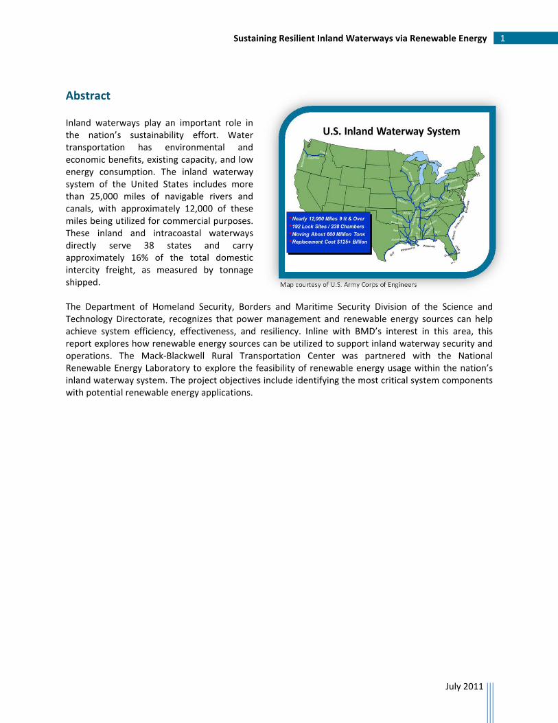
Photo courtesy of Arkansas State Highway Department
MBTC DHS 1108 – Sustaining Resilient Inland Waterways via Renewable Energy
Heather Nachtmann, Ph.D. Letitia M. Pohl, Ph.D.
July 2011
University of Arkansas 4190 Bell Engineering Center Fayetteville, AR 72701 479.575.6026 – Office 479.575.7168 – Fax
Prepared for
Mack-Blackwell Rural Transportation Center National Transportation Security Center of Excellence
University of Arkansas
ACKNOWLEDGEMENT This material is based upon work supported by the U.S. Department of Homeland Security under Grant Award Number 2008-ST-061-TS003. DISCLAIMER The views and conclusions contained in this document are those of the authors and should not be interpreted as necessarily representing the official policies, either expressed or implied, of the U.S. Department of Homeland Security.
Sustaining Resilient Inland Waterways via Renewable Energy 1
July 2011
Abstract
Inland waterways play an important role in the nation’s sustainability effort. Water transportation has environmental and economic benefits, existing capacity, and low energy consumption. The inland waterway system of the United States includes more than 25,000 miles of navigable rivers and canals, with approximately 12,000 of these miles being utilized for commercial purposes. These inland and intracoastal waterways directly serve 38 states and carry approximately 16% of the total domestic intercity freight, as measured by tonnage shipped. The Department of Homeland Security, Borders and Maritime Security Division of the Science and Technology Directorate, recognizes that power management and renewable energy sources can help achieve system efficiency, effectiveness, and resiliency. Inline with BMD’s interest in this area, this report explores how renewable energy sources can be utilized to support inland waterway security and operations. The Mack‐Blackwell Rural Transportation Center was partnered with the National Renewable Energy Laboratory to explore the feasibility of renewable energy usage within the nation’s inland waterway system. The project objectives include identifying the most critical system components with potential renewable energy applications.
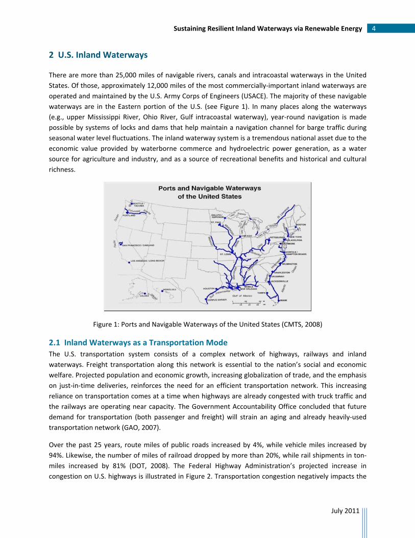
Map courtesy of U.S. Army Corps of Engineers
Sustaining Resilient Inland Waterways via Renewable Energy 2
July 2011
Table of Contents
Abstract ............................................................................................................................................ 1
Table of Contents ............................................................................................................................. 2
1 Introduction ................................................................................................................................. 3
2 U.S. Inland Waterways ................................................................................................................. 4
2.1 Inland Waterways as a Transportation Mode ...................................................................... 4
2.1.1 Coal Shipments on the Ohio River System ................................................................. 7
2.1.2 Grain Shipments on the Mississippi and Illinois Rivers .............................................. 8
2.2 Vulnerabilities and Resilience of Inland Waterways ............................................................ 9
3 Renewable Energy Sources ........................................................................................................ 10
3.1 Solar Energy ........................................................................................................................ 10
3.2 Wind Energy ....................................................................................................................... 11
3.3 Geothermal Energy ............................................................................................................ 12
3.4 Biomass Energy .................................................................................................................. 13
3.5 Hydropower ....................................................................................................................... 13
4 Inland Waterway Security .......................................................................................................... 15
4.1 United States Coast Guard ................................................................................................. 16
4.2 Maritime Domain Awareness ............................................................................................. 17
4.3 Port Security ....................................................................................................................... 20
4.4 Summary ............................................................................................................................ 20
5 Application of Renewable Energy to Inland Waterway Security ............................................... 20
6 Conclusions ................................................................................................................................ 21
References ..................................................................................................................................... 22

Sustaining Resilient Inland Waterways via Renewable Energy 3
July 2011
1 Introduction
Inland waterways play an important role in the nation’s sustainability effort. Water transportation has
environmental and economic benefits, existing capacity, and low energy consumption. The inland
waterway system of the United States includes more than 25,000 miles of navigable rivers and canals,
with approximately 12,000 of these miles being utilized for commercial purposes. These inland and
intracoastal waterways directly serve 38 states and carry approximately 16% of the total domestic
intercity freight, as measured by tonnage shipped (USACE, 2009). Inland waterways are recognized as
energy‐friendly. The nearly 200 active locks maintained by the U.S. Army Corps of Engineers (USACE) to
facilitate commercial shipping are operated primarily by gravity. Hydropower, generated mostly from
dams, provides about 17% of the world’s installed electrical power capacity and over 72% of its
renewable energy (IHA, 2011).
The Department of Homeland Security (DHS), Borders and Maritime Security Division (BMD) of the
Science and Technology Directorate, recognizes that power management and renewable energy sources
can help achieve system efficiency, effectiveness, and resiliency. Inline with BMD’s interest in this area,
this report explores how renewable energy sources can be utilized to support inland waterway security
and operations. The Mack‐Blackwell Rural Transportation Center (MBTC) was partnered with the
National Renewable Energy Laboratory (NREL) to explore the feasibility of renewable energy usage
within the nation’s inland waterway system.
The project objectives include:
Identify the most critical components with potential renewable energy applications within
the nation’s inland waterway system,
Identify areas for immediate, quick‐win application of renewable energy within the critical
components of the system, and
Indicate a long‐term strategic way forward in implementing renewable energy in the inland
waterways.
The Sector Specific Agency responsible for maritime security is the U.S. Coast Guard (USCG), which is a
component organization of DHS. The research potentially aids in accomplishing two of the USCG’s
primary missions: to ensure the security of the ports, waterways and coastal areas and to protect and
preserve the environment.
Section 2 outlines the contribution inland waterways make to the nation’s economy as a mode of
transportation. Section 3 summarizes sources of renewable energy and Section 4 identifies the elements
involved in inland waterway security. Section 5 discusses potential applications of renewable energy to
inland waterways security and Section 6 summarizes the study conclusions.
Sustaining Resilient Inland Waterways via Renewable Energy 4
July 2011
2 U.S. Inland Waterways
There are more than 25,000 miles of navigable rivers, canals and intracoastal waterways in the United
States. Of those, approximately 12,000 miles of the most commercially‐important inland waterways are
operated and maintained by the U.S. Army Corps of Engineers (USACE). The majority of these navigable
waterways are in the Eastern portion of the U.S. (see Figure 1). In many places along the waterways
(e.g., upper Mississippi River, Ohio River, Gulf intracoastal waterway), year‐round navigation is made
possible by systems of locks and dams that help maintain a navigation channel for barge traffic during
seasonal water level fluctuations. The inland waterway system is a tremendous national asset due to the
economic value provided by waterborne commerce and hydroelectric power generation, as a water
source for agriculture and industry, and as a source of recreational benefits and historical and cultural
richness.
Figure 1: Ports and Navigable Waterways of the United States (CMTS, 2008)
2.1 Inland Waterways as a Transportation Mode
The U.S. transportation system consists of a complex network of highways, railways and inland
waterways. Freight transportation along this network is essential to the nation’s social and economic
welfare. Projected population and economic growth, increasing globalization of trade, and the emphasis
on just‐in‐time deliveries, reinforces the need for an efficient transportation network. This increasing
reliance on transportation comes at a time when highways are already congested with truck traffic and
the railways are operating near capacity. The Government Accountability Office concluded that future
demand for transportation (both passenger and freight) will strain an aging and already heavily‐used
transportation network (GAO, 2007).
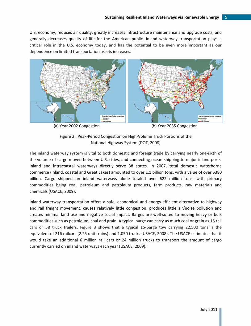
Over the past 25 years, route miles of public roads increased by 4%, while vehicle miles increased by
94%. Likewise, the number of miles of railroad dropped by more than 20%, while rail shipments in ton‐
miles increased by 81% (DOT, 2008). The Federal Highway Administration’s projected increase in
congestion on U.S. highways is illustrated in Figure 2. Transportation congestion negatively impacts the
Sustaining Resilient Inland Waterways via Renewable Energy 5
July 2011
U.S. economy, reduces air quality, greatly increases infrastructure maintenance and upgrade costs, and
generally decreases quality of life for the American public. Inland waterway transportation plays a
critical role in the U.S. economy today, and has the potential to be even more important as our
dependence on limited transportation assets increases.
(a) Year 2002 Congestion (b) Year 2035 Congestion
Figure 2: Peak‐Period Congestion on High‐Volume Truck Portions of the
National Highway System (DOT, 2008)
The inland waterway system is vital to both domestic and foreign trade by carrying nearly one‐sixth of
the volume of cargo moved between U.S. cities, and connecting ocean shipping to major inland ports.
Inland and intracoastal waterways directly serve 38 states. In 2007, total domestic waterborne
commerce (inland, coastal and Great Lakes) amounted to over 1.1 billion tons, with a value of over $380
billion. Cargo shipped on inland waterways alone totaled over 622 million tons, with primary
commodities being coal, petroleum and petroleum products, farm products, raw materials and
chemicals (USACE, 2009).
Inland waterway transportation offers a safe, economical and energy‐efficient alternative to highway
and rail freight movement, causes relatively little congestion, produces little air/noise pollution and
creates minimal land use and negative social impact. Barges are well‐suited to moving heavy or bulk
commodities such as petroleum, coal and grain. A typical barge can carry as much coal or grain as 15 rail
cars or 58 truck trailers. Figure 3 shows that a typical 15‐barge tow carrying 22,500 tons is the
equivalent of 216 railcars (2.25 unit trains) and 1,050 trucks (USACE, 2008). The USACE estimates that it
would take an additional 6 million rail cars or 24 million trucks to transport the amount of cargo
currently carried on inland waterways each year (USACE, 2009).
Sustaining Resilient Inland Waterways via Renewable Energy 6
July 2011
Figure 3: Modal Carrying Capacity (USACE, 2008)
Without the use of inland waterways as a transportation mode, waterborne cargo would have to be
transferred to highway and rail, thereby increasing shipment costs, highway and rail congestion, wear
and tear on rail systems and road surfaces, and air pollution. Considering just one commodity, there are
over 180 million tons of coal shipped on inland waterways each year (USACE, 2008). The Federal
Highway Administration estimates that for every one million tons of coal diverted from barge to truck,
45,600 additional trucks would be needed to move the coal at a cost of $1.14 million in surface repairs
alone (USACE, 2002). Towboat emissions per ton‐mile are considerably less than truck emissions, with
the comparative fuel efficiency as noted in Figure 4.
Figure 4: Modal Fuel Efficiency (USACE, 2009)
How far one gallon of fuel moves one
ton of freight, average by mode…

Sustaining Resilient Inland Waterways via Renewable Energy 7
July 2011
The economic health of numerous industries and geographic regions and the security of tens of
thousands of U.S. jobs (IRS, 2010) are tied to inland waterway transportation. Two important
waterborne commodities are explored in further detail below.
2.1.1 Coal Shipments on the Ohio River System
Coal accounts for half of our nation’s electricity production, and over 20% of U.S. coal is transported on
inland waterways (USACE, 2009). This dependence on barge shipments is perhaps best illustrated in the
Ohio River basin, where coal represents 55% of waterborne cargo. Two major coal fields are located
near the Ohio River: the Appalachian Region and the Illinois Basin. In 2007, the Appalachian Region
alone produced 377.8 million tons of coal, or 33% of total U.S. coal production. Almost 37% of
Appalachian coal is shipped by waterway, 41% by rail, 16% by truck, and 6% by conveyor/slurry (USACE,
2008). Many coal‐consuming cement, steel and power plants have been built along the Ohio River
system, due in part to a plentiful water supply and the proximity of the waterways to coal fields. Figure 5
shows the locations and relative capacities of waterside power plants. Regional electrical costs/rates,
and therefore the economic viability of the area, depend on the reliability and security of the inland
waterways (Güler, 2009).
Figure 5: Waterside Electric Power Plants in the Ohio River Basin (USACE, 2008)
Sustaining Resilient Inland Waterways via Renewable Energy 8
July 2011
2.1.2 Grain Shipments on the Mississippi and Illinois Rivers
Over 60% of farm exports move on inland waterways, which translates to nearly 80 million tons of grain
that move by barge annually (USACE, 2009). In contrast, almost all domestic shipments of grain are
moved by either truck or short line rail. This difference in mode selection is due to the savings barge
travel affords when travel distances are long, as in trips from the upper Midwest to a Gulf Coast seaport.
As the domestic market for grain dramatically increases (primarily due to ethanol production increases),
the trend is towards a greater reliance on trucking for grain shipment. This has led to increasing concern
with the wear and tear on rural roads and bridges, and has motivated advocacy for inland waterway use
for domestic grain shipments (Frittelli, 2005).
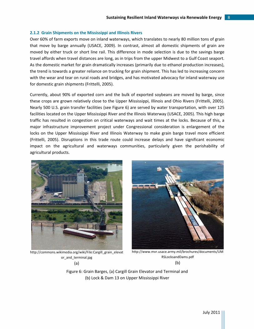
Currently, about 90% of exported corn and the bulk of exported soybeans are moved by barge, since
these crops are grown relatively close to the Upper Mississippi, Illinois and Ohio Rivers (Frittelli, 2005).
Nearly 500 U.S. grain transfer facilities (see Figure 6) are served by water transportation, with over 125
facilities located on the Upper Mississippi River and the Illinois Waterway (USACE, 2005). This high barge
traffic has resulted in congestion on critical waterways and wait times at the locks. Because of this, a
major infrastructure improvement project under Congressional consideration is enlargement of the
locks on the Upper Mississippi River and Illinois Waterway to make grain barge travel more efficient
(Frittelli, 2005). Disruptions in this trade route could increase delays and have significant economic
impact on the agricultural and waterways communities, particularly given the perishability of
agricultural products.
http://commons.wikimedia.org/wiki/File:Cargill_grain_elevat
or_and_terminal.jpg
(a)
http://www.mvr.usace.army.mil/brochures/documents/UM
RSLocksandDams.pdf
(b)
Figure 6: Grain Barges, (a) Cargill Grain Elevator and Terminal and
(b) Lock & Dam 13 on Upper Mississippi River

Sustaining Resilient Inland Waterways via Renewable Energy 9
July 2011
The future of the U.S. grain export market is dependent on a number of complex issues. An Institute of
Water Resources study, which attempts to forecast grain shipments on the Upper Mississippi River,
identifies three key changes occurring in the world grain trade which could impact both foreign demand
and U.S. surplus: Brazil’s soybean sector, China’s agricultural import demand, and domestic ethanol
production (Wilson et al., 2006). Future developments, while uncertain, have the potential to greatly
impact the U.S. grain export market, thereby affecting the quantity of grain exports shipped on the
rivers.
2.2 Vulnerabilities and Resilience of Inland Waterways
The Mississippi River and its tributaries have been described as a lifeline to the U.S. economy. Inland
waterways as a transportation mode contribute significantly to the U.S. economy, as measured by the
value of the domestic and export cargo transported on barges, and by the tens of thousands of jobs
associated with river transport and inland ports. The rivers are also critical sources of water for
agricultural irrigation, industrial applications, and hydropower. Major metropolitan areas, such as
Pittsburgh, Cincinnati, St. Louis, Memphis and New Orleans, as well as thousands of smaller
communities, were located to take advantage of commercial and recreational opportunities offered by
the rivers. Critical infrastructure along inland waterways includes nuclear power plants, military
installations, major rail and highway bridges and locks and dams.
As an important component of the nation’s transportation system, inland waterways are vulnerable to
disruptions due to failures of aging infrastructure, flooding, accidents, hazardous cargo spills and natural
disasters (e.g., earthquake in New Madrid Seismic Zone). The waterways are also potential means for
launching terrorist attacks on waterside infrastructure and population centers. The resilience of inland
waterways is the ability of the system to respond or recover from potential threats due to either natural
or manmade causes.
Figure 7: Hannibal Lock and Dam on the Ohio River has two navigation locks on the left and a
hydropower plant on the right (Source: http://www.lrp.usace.army.mil/nav/hanni.htm)

Sustaining Resilient Inland Waterways via Renewable Energy 10
July 2011
3 Renewable Energy Sources
Renewable energy comes from natural resources such as sunlight, wind, geothermal heat, biomass and
water. These resources are virtually inexhaustible over time, but are limited in the amount of energy
that is available per unit of time. Renewable energy is a relatively small portion of global and U.S. energy
production, but its influence is growing. The 2008 Renewable Energy Data Book, produced in July 2009
by the National Renewable Energy Laboratory, provides facts and figures on renewable energy in the
U.S. and worldwide (DOE, 2009). Renewable energy installations nearly tripled between 2000 and 2008,
with the largest growth in capacity in the wind and solar photovoltaics sectors. Figure 8 indicates that
renewable energy represents almost 10% of total energy generation in the U.S. in 2008.
Figure 8: U.S. Energy Consumption for 2008 (DOE, 2009)
The following sections summarize the major categories of renewable energy sources: solar, wind,
geothermal, biomass and hydropower. The primary source of technical information and figures for this
section is the NREL website (NREL, 2010).
3.1 Solar Energy
The sun is the Earth’s primary source of energy. Solar power is the conversion of sunlight into usable
energy. The two most widely‐deployed solar energy technologies are Photovoltaics and Concentrated
Solar Power. Photovoltaic (PV) solar cells convert sunlight directly into electricity. The PV effect – the
process of converting light (photons) to electricity (voltage) – was discovered at Bell Telephone in 1954
when scientists realized that silicon created an electric charge when exposed to sunlight. Solar panels, or

Sustaining Resilient Inland Waterways via Renewable Energy 11
July 2011
solar panels combined together to create a solar array, provide power to homes, businesses and
industrial applications. Climate conditions and environmental factors have a huge impact on the amount
of sunlight, and therefore the amount of solar energy received by a PV array.
Concentrated Solar Power (CSP) amplifies the strength and heat of the sun by channeling sunlight
through an optical lens. The conversion of sunlight into heat is used to turn water into steam, which
then powers a turbine and generates electricity. Three main types of CSP systems include linear
concentrator, dish/engine, and power tower systems. CSP systems have several advantages over PV
systems for large‐scale use, including less variable power generation, energy storage capability and
potential for hybridization. Figure 9 illustrates the PV and CSP resource potential for the Unites States.
(a)
(b)
Figure 9: U.S. Solar Resource Maps for (a) Photovoltaic Solar and (b) Concentrating Solar Power
(Source: http://www.nrel.gov/gis/solar.html)
3.2 Wind Energy
Wind energy has been harnessed for hundreds of years for uses such as pumping water and grinding
grain. Modern wind turbines have made it possible to convert the wind’s energy into electricity.
Propeller‐like blades, which are mounted on a tower, spin with the wind and turn a shaft, which
generates electricity. A large number of wind turbines can be built close together to form a wind plant.
Figure 10 shows the predicted mean annual wind speeds at an 80 meter height.

Sustaining Resilient Inland Waterways via Renewable Energy 12
July 2011
Figure 10: U.S. Wind Resource Map at 80 Meters
(Source: http://www.windpoweringamerica.gov/wind_maps.asp#us)
3.3 Geothermal Energy
Geothermal energy is in the form of heat stored in the earth – typically hot water or steam reservoirs
deep in the earth or located near the earth’s surface. Geothermal energy can be used in direct‐use
applications in buildings, roads, agriculture, and industrial plants. Hot water and steam from reservoirs
can also be used to drive generators and produce electricity. Figure 11 shows the U.S. locations of
identified hydrothermal sites and the favorability of deep enhanced geothermal systems (EGS).
Figure 11: U.S. Geothermal Resource Map
(Source: http://www.nrel.gov/gis/images/geothermal_resource2009‐final.jpg)
Sustaining Resilient Inland Waterways via Renewable Energy 13
July 2011
3.4 Biomass Energy
Biomass energy is derived from plants. Biomass sources can be used in several ways: as liquid fuels for
transportation (biofuels); for generating electricity, typically through burning biomass directly; and by
converting biomass into chemicals for making products that are typically made from petroleum. Fumes
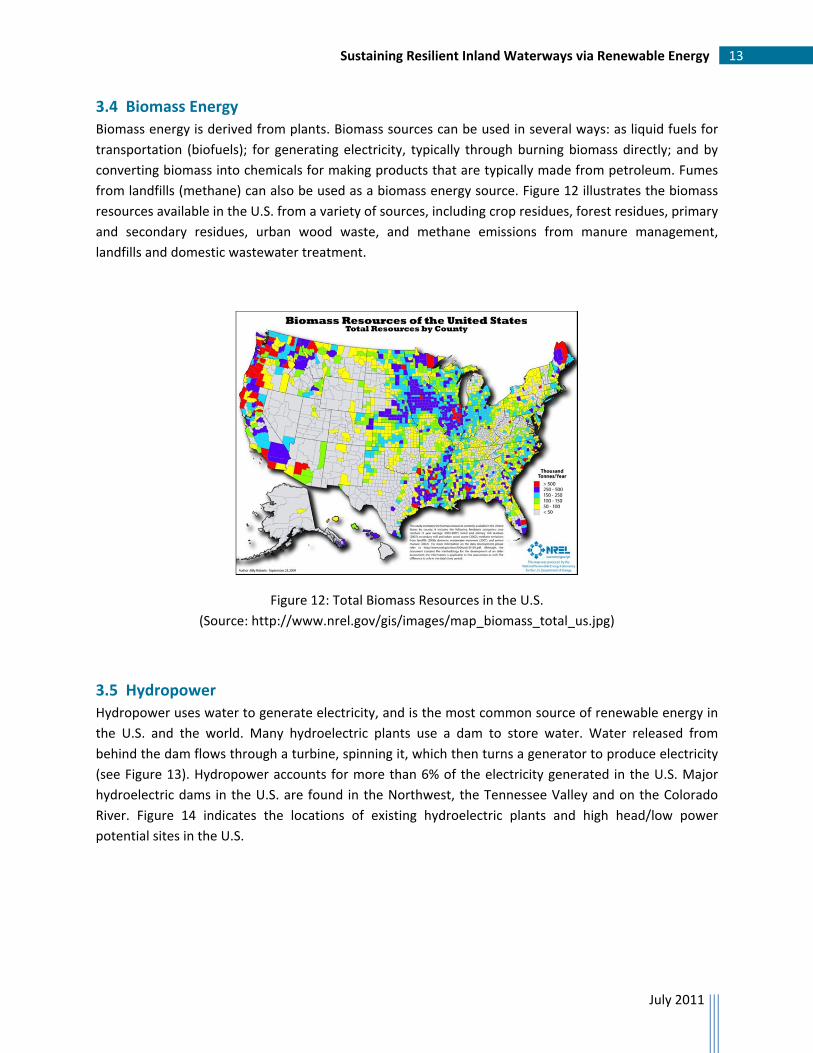
from landfills (methane) can also be used as a biomass energy source. Figure 12 illustrates the biomass
resources available in the U.S. from a variety of sources, including crop residues, forest residues, primary
and secondary residues, urban wood waste, and methane emissions from manure management,
landfills and domestic wastewater treatment.
Figure 12: Total Biomass Resources in the U.S.
(Source: http://www.nrel.gov/gis/images/map_biomass_total_us.jpg)
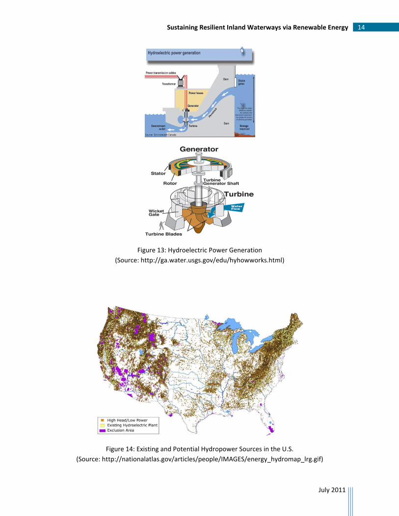
3.5 Hydropower
Hydropower uses water to generate electricity, and is the most common source of renewable energy in
the U.S. and the world. Many hydroelectric plants use a dam to store water. Water released from
behind the dam flows through a turbine, spinning it, which then turns a generator to produce electricity
(see Figure 13). Hydropower accounts for more than 6% of the electricity generated in the U.S. Major
hydroelectric dams in the U.S. are found in the Northwest, the Tennessee Valley and on the Colorado
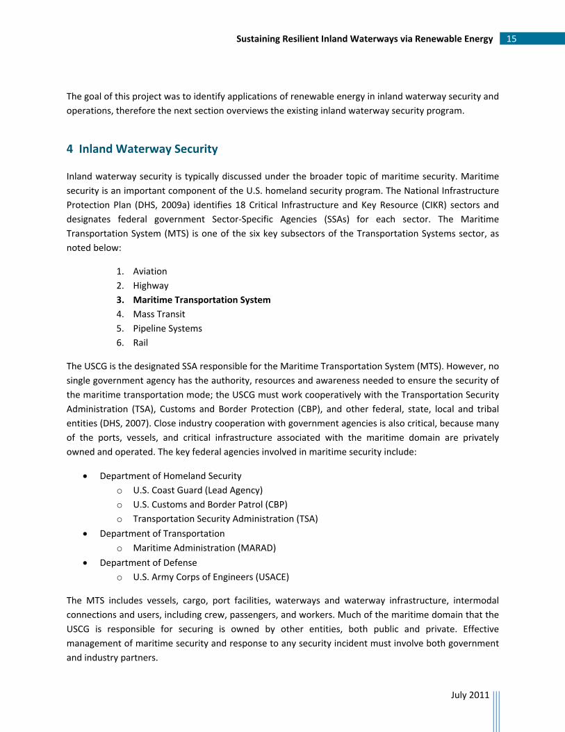
River. Figure 14 indicates the locations of existing hydroelectric plants and high head/low power
potential sites in the U.S.
Sustaining Resilient Inland Waterways via Renewable Energy 14
July 2011
Figure 13: Hydroelectric Power Generation
(Source: http://ga.water.usgs.gov/edu/hyhowworks.html)
Figure 14: Existing and Potential Hydropower Sources in the U.S.
(Source: http://nationalatlas.gov/articles/people/IMAGES/energy_hydromap_lrg.gif)
Sustaining Resilient Inland Waterways via Renewable Energy 15
July 2011
The goal of this project was to identify applications of renewable energy in inland waterway security and
operations, therefore the next section overviews the existing inland waterway security program.
4 Inland Waterway Security
Inland waterway security is typically discussed under the broader topic of maritime security. Maritime
security is an important component of the U.S. homeland security program. The National Infrastructure
Protection Plan (DHS, 2009a) identifies 18 Critical Infrastructure and Key Resource (CIKR) sectors and
designates federal government Sector‐Specific Agencies (SSAs) for each sector. The Maritime
Transportation System (MTS) is one of the six key subsectors of the Transportation Systems sector, as
noted below:
1. Aviation
2. Highway
3. Maritime Transportation System
4. Mass Transit
5. Pipeline Systems
6. Rail
The USCG is the designated SSA responsible for the Maritime Transportation System (MTS). However, no
single government agency has the authority, resources and awareness needed to ensure the security of
the maritime transportation mode; the USCG must work cooperatively with the Transportation Security
Administration (TSA), Customs and Border Protection (CBP), and other federal, state, local and tribal
entities (DHS, 2007). Close industry cooperation with government agencies is also critical, because many
of the ports, vessels, and critical infrastructure associated with the maritime domain are privately
owned and operated. The key federal agencies involved in maritime security include:
Department of Homeland Security
o U.S. Coast Guard (Lead Agency)
o U.S. Customs and Border Patrol (CBP)
o Transportation Security Administration (TSA)
Department of Transportation
o Maritime Administration (MARAD)
Department of Defense
o U.S. Army Corps of Engineers (USACE)
The MTS includes vessels, cargo, port facilities, waterways and waterway infrastructure, intermodal
connections and users, including crew, passengers, and workers. Much of the maritime domain that the
USCG is responsible for securing is owned by other entities, both public and private. Effective
management of maritime security and response to any security incident must involve both government
and industry partners.
Sustaining Resilient Inland Waterways via Renewable Energy 16
July 2011
The Maritime Transportation Security Act of 2002 (Public Law, 2002) and the Safe Port Act of 2006
(Public Law, 2006) added important security mandates that are implemented via a number of federal
strategies and plans. Overarching directives guiding maritime security include the National Strategy for
Homeland Security, Presidential Directives HSPD‐7 and NSPD‐41/HSPD‐13 (HSPD, 2003), and the
National Strategy for Maritime Security.
4.1 United States Coast Guard
The USCG is a multi‐mission maritime service, one of the fived armed services and a component of the
Department of Homeland Security. Its mission is to protect the public, the environment, and U.S.
economic interests in the nation’s ports and waterways. The USCG serves as the SSA for the Maritime
transportation mode.
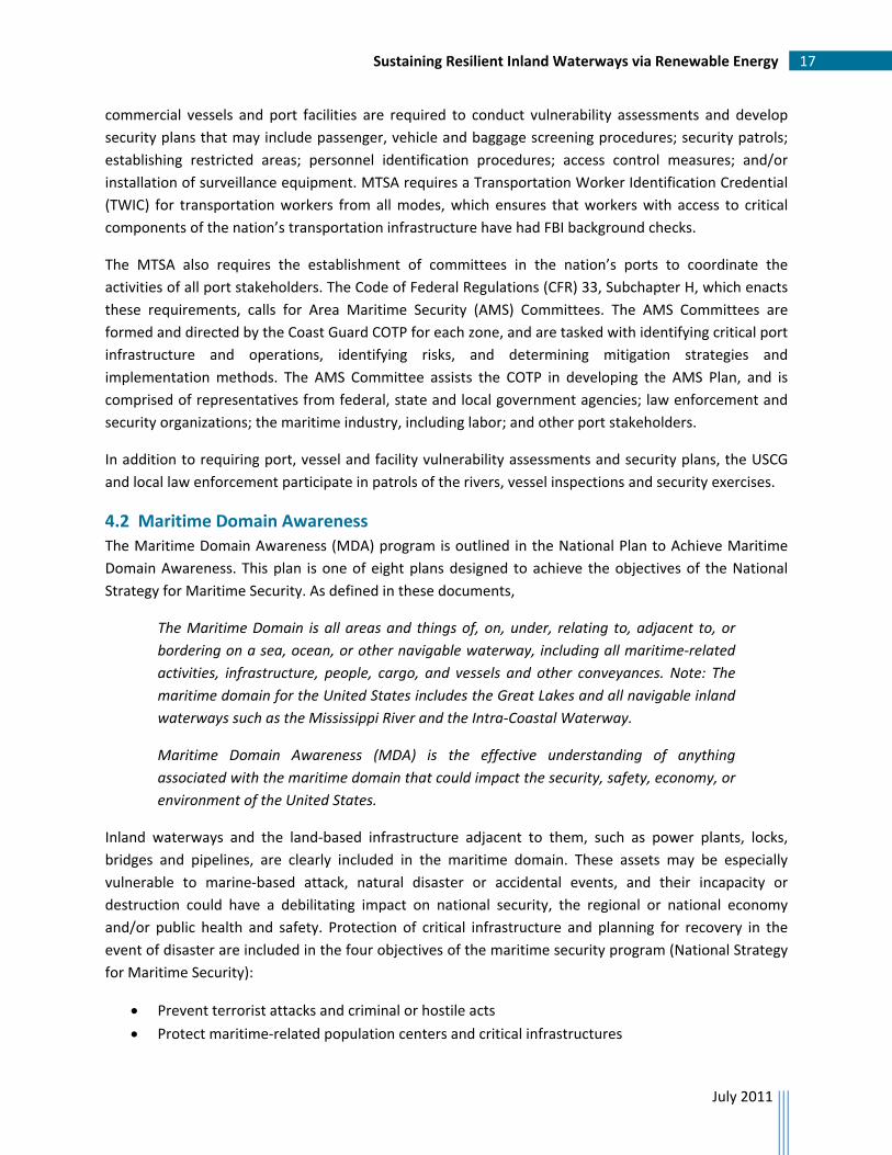
The USCG operational structure divides the U.S. into Coast Guard Districts and Zones, under which the
security of the inland waterways in a given zone is the responsibility of the Captain of the Port (COTP).
There are nine Coast Guard Districts. The Eighth District, which is the largest geographically (see Figure
15), covers all or part of 26 states throughout the Gulf Coast and the Midwest (USCG, 2008). The Eighth
District contains most of the navigable inland waterways in the U.S., and includes major inland ports
such as Memphis, St. Louis, Louisville and Pittsburgh. The system of rivers in the Eighth District is
referred to as the “Western Rivers,” and includes primarily the Mississippi River and its tributaries.
(a) (b)
Figure 15: (a) U.S. Coast Guard District Map, (b) Eighth District Logo (Source: http://www.uscg.mil/top/units/, retrieved January 5, 2010)
The Maritime Transportation Security Act of 2002 (MTSA) requirements focus the USCG on three
primary maritime security activities: port security, vessel security and facility security. Certain types of
Sustaining Resilient Inland Waterways via Renewable Energy 17
July 2011
commercial vessels and port facilities are required to conduct vulnerability assessments and develop
security plans that may include passenger, vehicle and baggage screening procedures; security patrols;
establishing restricted areas; personnel identification procedures; access control measures; and/or
installation of surveillance equipment. MTSA requires a Transportation Worker Identification Credential
(TWIC) for transportation workers from all modes, which ensures that workers with access to critical
components of the nation’s transportation infrastructure have had FBI background checks.
The MTSA also requires the establishment of committees in the nation’s ports to coordinate the
activities of all port stakeholders. The Code of Federal Regulations (CFR) 33, Subchapter H, which enacts
these requirements, calls for Area Maritime Security (AMS) Committees. The AMS Committees are
formed and directed by the Coast Guard COTP for each zone, and are tasked with identifying critical port
infrastructure and operations, identifying risks, and determining mitigation strategies and
implementation methods. The AMS Committee assists the COTP in developing the AMS Plan, and is
comprised of representatives from federal, state and local government agencies; law enforcement and
security organizations; the maritime industry, including labor; and other port stakeholders.
In addition to requiring port, vessel and facility vulnerability assessments and security plans, the USCG
and local law enforcement participate in patrols of the rivers, vessel inspections and security exercises.
4.2 Maritime Domain Awareness
The Maritime Domain Awareness (MDA) program is outlined in the National Plan to Achieve Maritime
Domain Awareness. This plan is one of eight plans designed to achieve the objectives of the National
Strategy for Maritime Security. As defined in these documents,
The Maritime Domain is all areas and things of, on, under, relating to, adjacent to, or
bordering on a sea, ocean, or other navigable waterway, including all maritime‐related
activities, infrastructure, people, cargo, and vessels and other conveyances. Note: The
maritime domain for the United States includes the Great Lakes and all navigable inland
waterways such as the Mississippi River and the Intra‐Coastal Waterway.
Maritime Domain Awareness (MDA) is the effective understanding of anything
associated with the maritime domain that could impact the security, safety, economy, or
environment of the United States.
Inland waterways and the land‐based infrastructure adjacent to them, such as power plants, locks,
bridges and pipelines, are clearly included in the maritime domain. These assets may be especially
vulnerable to marine‐based attack, natural disaster or accidental events, and their incapacity or
destruction could have a debilitating impact on national security, the regional or national economy
and/or public health and safety. Protection of critical infrastructure and planning for recovery in the
event of disaster are included in the four objectives of the maritime security program (National Strategy
for Maritime Security):
Prevent terrorist attacks and criminal or hostile acts
Protect maritime‐related population centers and critical infrastructures

Sustaining Resilient Inland Waterways via Renewable Energy 18
July 2011
Minimize damage and expedite recovery
Safeguard the ocean and its resources
Achieving awareness of the total maritime domain is challenging due to the vastness of the oceans, the
great length of shorelines and the size of port areas. The goal of MDA is to identify threats as early and
as distant from our shores as possible. However, there is also a real possibility that terrorist threats are
within our borders or are able to cross our borders undetected. In these cases, the nearly 12,000 miles
of inland waterways can become passageways for terrorists and the associated infrastructure can
become vulnerable to attack.
A major component of MDA is the identification and tracking of marine vessels within or near U.S.
territorial waters, using Automatic Identification Systems (AIS). These onboard systems, when activated,
automatically transmit information such as the name of the vessel, its position, speed, course and
destination. Originally developed to improve navigation safety, AIS allows a vessel’s crew to track the
movements of other similarly equipped vessels and allows the USCG to actively monitor and
communicate with vessels through its Vessel Traffic Service (VTS). This is helpful in preventing vessel
collisions, allisions (when a vessel hits a fixed object) and groundings. One of the major limitations of AIS
as a security aid is that a vessel must have the system installed and activated in order to be tracked by
the USCG and other vessels. AIS is therefore useful in tracking these “compliant” vessels but provides no
awareness of vessels that do not have AIS installed or choose to turn it off. The accuracy of the AIS
information received is also dependent on the vessel operator’s willingness/ability to program accurate
information into the system (U.S. House of Representatives, 2009). These limitations are particularly
relevant for inland waterways, in that most of the vessels operating on inland waterways are not
required to be equipped with AIS.
Under current regulations, vessels not on an international voyage are required to use AIS only in VTS
areas (major ports and coastal areas). The only VTS on the inland waterways is in Louisville, KY. Its stated
purpose is to help vessel operators deal with high water conditions on the Ohio River, and it is activated
only during high water levels, which typically occurs during the spring months (USCG, 2010a). However,
a DHS/Coast Guard Notice of Proposed Rulemaking, dated December 16, 2008, would expand AIS
applicability to all U.S. navigable waters and expand the types of vessels required to carry AIS. The
proposed changes would provide the Coast Guard with the ability to detect and monitor AIS‐equipped
vessels in areas where little or no shore‐side vessel tracking currently exists, such as some inland
waterways. This ability would improve navigation safety and heighten overall MDA for inland
waterways, by potentially identifying threats to maritime transportation systems and infrastructure. In
order to appropriately respond to marine‐based threats to infrastructure, however, the information
must be disseminated in a timely manner to the agencies responsible for infrastructure protection.
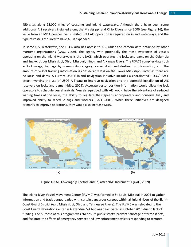
Since 2006, the USCG has expanded its AIS monitoring capabilities through a major acquisition program
called the Nationwide Automatic Identification System (NAIS) (GAO, 2009). Figure 16, which shows the
AIS coverage before and after the first phase of NAIS, indicates that the increased coverage is primarily
along the three seacoasts and the Great Lakes region. Full implementation of NAIS will involve installing
receivers, transmitters and other equipment on towers, buildings, bridges and other structures at up to
Sustaining Resilient Inland Waterways via Renewable Energy 19
July 2011
450 sites along 95,000 miles of coastline and inland waterways. Although there have been some
additional AIS receivers installed along the Mississippi and Ohio Rivers since 2006 (see Figure 16), the
value from an MDA perspective is limited until AIS operation is required on inland waterways, and the
type of vessels required to have AIS is expanded.
In some U.S. waterways, the USCG also has access to AIS, radar and camera data obtained by other
maritime organizations (GAO, 2009). The agency with potentially the most awareness of vessels
operating on the inland waterways is the USACE, which operates the locks and dams on the Columbia
and Snake, Upper Mississippi, Ohio, Missouri, Illinois and Arkansas Rivers. The USACE compiles data such
as lock usage, tonnage by commodity category, vessel draft and destination information, etc. The
amount of vessel tracking information is considerably less on the Lower Mississippi River, as there are
no locks and dams. A current USACE inland navigation initiative includes a coordinated USCG/USACE
effort involving the use of USCG AIS data to improve navigation and the potential installation of AIS
receivers on locks and dams (Kidby, 2009). Accurate vessel position information would allow the lock
operators to schedule vessel arrivals. Vessels equipped with AIS would have the advantage of reduced
waiting times at the locks, the ability to regulate their speeds appropriately and conserve fuel, and
improved ability to schedule tugs and workers (GAO, 2009). While these initiatives are designed
primarily to improve operations, they would also increase MDA.
(a)
(b)
Figure 16: AIS Coverage (a) before and (b) after NAIS Increment 1 (GAO, 2009)
The Inland River Vessel Movement Center (IRVMC) was formed in St. Louis, Missouri in 2003 to gather
information and track barges loaded with certain dangerous cargoes within all inland rivers of the Eighth
Coast Guard District (e.g., Mississippi, Ohio and Tennessee Rivers). The IRVMC was relocated to the
Coast Guard Navigation Center in Alexandria, VA but was deactivated in October 2010 due to lack of
funding. The purpose of this program was “to ensure public safety, prevent sabotage or terrorist acts,
and facilitate the efforts of emergency services and law enforcement officers responding to terrorist
Sustaining Resilient Inland Waterways via Renewable Energy 20
July 2011
attacks” (33 CFR, part 165). Regulations required reporting of barge and tow locations and movements
by the vessel operators or fleeting facility operators via telephone, paper or internet, although the Coast
Guard encouraged automatic reporting using systems such as AIS.
4.3 Port Security
The U.S. governmental efforts to improve maritime security have focused on port security, as evidenced
by the almost $2.5 billion dollars awarded through the Port Security Grant Program (PSGP) during FYs
2002‐2010. The objective of the PSGP is to assist ports in strengthening critical port infrastructure
against potential terrorist attacks, with a focus on “increased port‐wide risk management; enhanced
domain awareness; training and exercises; and further capabilities to prevent, detect, respond to, and
recover from attacks involving improvised explosive devices (IEDs) and other non‐conventional
weapons” (DHS, 2009b).
Congressional direction has been to fund those ports exhibiting the greatest risk. While a number of
inland ports have received grants, the bulk of funding has gone to major sea ports. The FY2010 PSGP
Application Kit identifies seven Group 1 ports, including three on the West Coast, two on the East Coast
and two on the Gulf of Mexico, which combined, received 60% of the allocated funds for FY2010.
4.4 Summary
The maritime security program on inland waterways consists primarily of the USCG physical presence on
the waterways through vessel inspections and patrols of the rivers by USCG “small boats” and local law
enforcement, and through processes and procedures mandated by federal laws. Maritime employees
are screened and certified through the Transportation Workers Identification Card (TWIC) program,
which requires FBI background checks on all workers with access to vessels and port facilities. Vessel and
facility owners/operators are required to develop and maintain vulnerability assessments and security
plans. Maritime security stakeholders (government and industry) in each port region coordinate
activities and plan for incident response through the USCG‐led Area Maritime Security Committees. This
planning includes security exercises ranging from tabletop exercises to participation in large‐scale
national exercises, such as the New Madrid Fault Exercise conducted during May 2011 in Memphis, TN.
5 Application of Renewable Energy to Inland Waterway Security
The USCG is proactive in reducing greenhouse emissions. The USCG’s energy conservation program is
outlined in their Energy Management Strategy, dated May 2010 (USCG, 2010b). Their vision is to
“become the model mid‐sized federal agency for sustainable and reliable energy management.” The
USCG has implemented innovative uses of renewable energy for facilities, such as the Coast Guard Yard
in Baltimore, MD, which is now powered by methane gas emitted by a local landfill. There are, however,
no current applications of renewable energy directly supporting inland waterway security.
Inland waterway security is achieved primarily through the processes and procedures identified in
Section 4. In discussions with DHS S&T BMD personnel, the research team was given specific direction to
Sustaining Resilient Inland Waterways via Renewable Energy 21
July 2011
identify USCG‐owned equipment used in security operations that could be powered by renewable
energy sources. This directed focus excluded consideration of other potential renewable energy
application areas, such as the use of biofuels in USCG small boats that patrol the rivers, the use of
renewable energy sources to power USCG facilities along the rivers, and power sources for USACE
equipment used to support inland waterway operations. Under these guidelines, there is currently not
an obvious application of renewable energy technology to USCG‐owned equipment used for security.
A future application of renewable energy to inland waterway security is powering or augmenting
traditional power sources for the USCG‐owned equipment that monitors vessels equipped with AIS.
Collection of AIS data contributes to maritime domain awareness and therefore plays a role in maritime
security. Unfortunately, the full benefit of collecting AIS data on inland waterways is not achievable in
the short term because current monitoring coverage is available at only a few major inland ports and
the majority of vessels operating on inland waterways are not required to be equipped with AIS onboard
systems.
6 Conclusions
The objective of this project is to explore how renewable energy resources can be used to support
inland waterway security. In particular, the goal is to identify USCG‐owned equipment used in security
operations that could be powered by renewable energy. This excludes consideration of USCG vessels
and facilities, and USACE‐owned equipment used for either inland waterway security or operations. This
report provides an overview of inland waterways and their contribution to the nation’s economy, an
overview of renewable energy sources, and a summary of the national maritime security program and
its application to inland waterways.
Within the BMD scope of interest, there were no critical components of the nation’s current inland
waterway security program that were identified as having potential to benefit from quick‐win
applications of renewable energy since the security program relies primarily on procedures and
processes and not equipment‐based systems. A potential application of renewable energy in inland
waterway security for the future is the USCG‐owned receivers and monitoring equipment that collect
AIS data from vessels on the nation’s navigable waterways. These systems, while prevalent in major
seaports and surrounding coastal regions, have not yet been implemented in the vast majority of inland
waterways. Their contribution to inland waterway security and maritime domain awareness will not be
realized until proposed legislation is passed that requires vessels operating on the rivers to be equipped
with AIS systems.
Sustaining Resilient Inland Waterways via Renewable Energy 22
July 2011
References Committee on the Marine Transportation System (CMTS), “National Strategy for the Marine Transportation System: A Framework for Action,” July 2008. Frittelli, J.F., CRS Report for Congress, “Grain Transport: Modal Trends and Infrastructure Implications,” January 2005. Government Accountability Office (GAO), “Transforming Transportation Policy for 21st Century,” GAO‐07‐1210SP, September 2007. Government Accountability Office, “Maritime Security: Vessel Tracking Systems Provide Key Information, but the Need for Duplicate Data Should be Reviewed,” GAO‐09‐337, March 2009. Güler, Çağlar Utku,“Ohio River Denial as a Transportation Corridor and its Economic Impacts on the Energy Industry,” Master’s Thesis, Air Force Institute of Technology, March 2009.
Homeland Security Presidential Directive / HSPD‐7, December 2003, Available at http://www.fas.org/irp/offdocs/nspd/hspd‐7.html, retrieved December 5, 2010.
Internal Revenue Service (IRS), “Inland Waterways Audit Techniques Guide: Chapter 1 – Overview of the Inland Waterway Industry,” Available at http://www.irs.gov/businesses/small/article/0,,id=200945,00.html, retrieved December 6, 2010. International Hydropower Association (IHA), “Advancing Sustainable Hydropower: 2011 Activity Report,” Available at http://www.hydropower.org/downloads/ActivityReports/2011‐12_Activity_Report‐web.pdf, retrieved July 19, 2011. Kidby, Michael F., U.S. Army Corps of Engineers, “Inland Navigation Safety Initiative,” Presentation at Inland Navigation Technology ‘09 Workshop, February 2009. “National Plan to Achieve Maritime Domain Awareness,” October 2005, Available at http://www.dhs.gov/xlibrary/assets/HSPD_MDAPlan.pdf, retrieved December 8, 2010. National Renewable Energy Laboratory, “Learning About Renewable Energy,” available at http://www.nrel.gov/learning/, retrieved November 28, 2010.
National Security Presidential Directive / NSPD‐41/HSPD‐13, December 2004, Available at http://www.fas.org/irp/offdocs/nspd/nspd41.pdf, retrieved December 5, 2010.
“National Strategy for Homeland Security,” October 2007, Available at http://www.dhs.gov/xlibrary/assets/nat_strat_homelandsecurity_2007.pdf, retrieved December 8, 2010.
“National Strategy for Maritime Security,” September 2005, Available at http://www.dhs.gov/xlibrary/assets/HSPD13_MaritimeSecurityStrategy.pdf, retrieved December 8, 2010.
Sustaining Resilient Inland Waterways via Renewable Energy 23
July 2011
Public Law 107‐295, “Maritime Transportation Security Act of 2002,” November 2002, Available at http://www.tsa.gov/assets/pdf/MTSA.pdf, retrieved December 5, 2010.
Public Law 109‐347, “Security and Accountability for Every (SAFE) Port Act of 2006,” October 2006, Available at http://www.gpo.gov/fdsys/pkg/PLAW‐109publ347/pdf/PLAW‐109publ347.pdf, retrieved December 8, 2010.
U.S. Army Corps of Engineers (USACE), “Waterways Facts,” 2002. Available at (http://education.usace.army.mil/navigation/waterwy.html), retrieved December 6, 2010. U.S. Army Corps of Engineers, Navigation Data Center, “The U.S. Waterway System – Transportation Facts,” December 2005, Available at http://www.ndc.iwr.usace.army.mil/factcard/fc05/factcard.pdf, retrieved December 6, 2010. U.S. Army Corps of Engineers, Great Lakes and Ohio River Division, “Great Lakes and Ohio River Navigation Systems Commerce Report, 2008.” Available at http://inlandwaterways.lrh.usace.army.mil/publications/, retrieved December 6, 2010. U.S. Army Corps of Engineers, Institute for Water Resources, “Inland Waterway Navigation, Value to the Nation,” 2009. Available at http://www.corpsresults.us/docs/VTNInlandNavBro_loresprd.pdfbrochure, retrieved December 6, 2010. U.S. Coast Guard (USCG), “District 8 Facts,” last modified April 29, 2008. Available at http://www.uscg.mil/d8/d8facts.asp, retrieved January 5, 2010. U.S. Coast Guard, Navigation Center, “Vessel Traffic Services,” Available at http://www.navcen.uscg.gov/?pageName=vtsMain , retrieved January 5, 2010a. U.S. Coast Guard, “United States Coast Guard Energy Management Strategy,” May 2010b. U.S. Department of Energy (DOE), National Renewable Energy Laboratory (NREL), “2008 Renewable Energy Data Book,” July 2009. U.S. Department of Homeland Security (DHS), “Maritime Modal Implementation Plan,” Transportation Sector‐Specific Plan as Input to the National Infrastructure Protection Plan, Maritime Modal Annex, 2007. U.S. Department of Homeland Security, “National Infrastructure Protection Plan,” February 2009a. U.S. Department of Homeland Security, “FY2010 Port Security Grant Program, Guidance and Application Kit,” December 2009b. U.S. Department of Transportation (DOT), Federal Highway Administration, “Freight Story 2008,” November 2008, available at http://ops.fhwa.dot.gov/freight/freight_analysis/freight_story/congestion.htm, retrieved December 6, 2010.

Sustaining Resilient Inland Waterways via Renewable Energy 24
July 2011
U.S. House of Representatives, Subcommittee on Coast Guard and Maritime Transportation of the Committee on Transportation and Infrastructure, “Hearing on Maritime Domain Awareness,” December 8, 2009. Wilson, William W., DeVuyst, Eric, Taylor, Richard, Dahl, Bruce and Koo, Won, “Longer‐Term Forecasting of Commodity Flows on the Mississippi River: Application to Grains and World Trade,” IWR Report 06‐NETS‐R‐12, Institute for Water Resources, U.S. Army Corps of Engineers, December 2006.