maxwell farms park - sonoma...
TRANSCRIPT

MAXWELL FARMS PARK
RESOURCE MANAGEMENT PLAN
Produced by
Joanna Becker
May, 1995

TABLE OF CONTENTS
SUMMARY INFORMATION ................................................................. 1
INTRODUCTION ..................................................................................... 2
SITE DESCRIPTION ............................................................................... 3
GOALS FOR MAXWELL PARK ............................................................ 5
OPPORTUNITIES AND CONSTRAINTS ................................................ 8
HISTORICAL SUMMARY ...................................................................... 11
PUBLIC USE ............................................................................................ 12
GEOPHYSICAL PROPERTIES ................................................................ 16
HYDROLOGY .......................................................................................... 18
ARCHAEOLOGY ..................................................................................... 20
VEGETATION .......................................................................................... 21
WILDLIFE ................................................................................................. 25
INFRASTRUCTURE ................................................................................. 27
EMERGENCY PROCEDURES ................................................................. 31
OPERATIONS AND MANAGEMENT ..................................................... 33
BIBLIOGRAPHY ........................................................................................ 35
APPENDIX ................................................................................................. 36
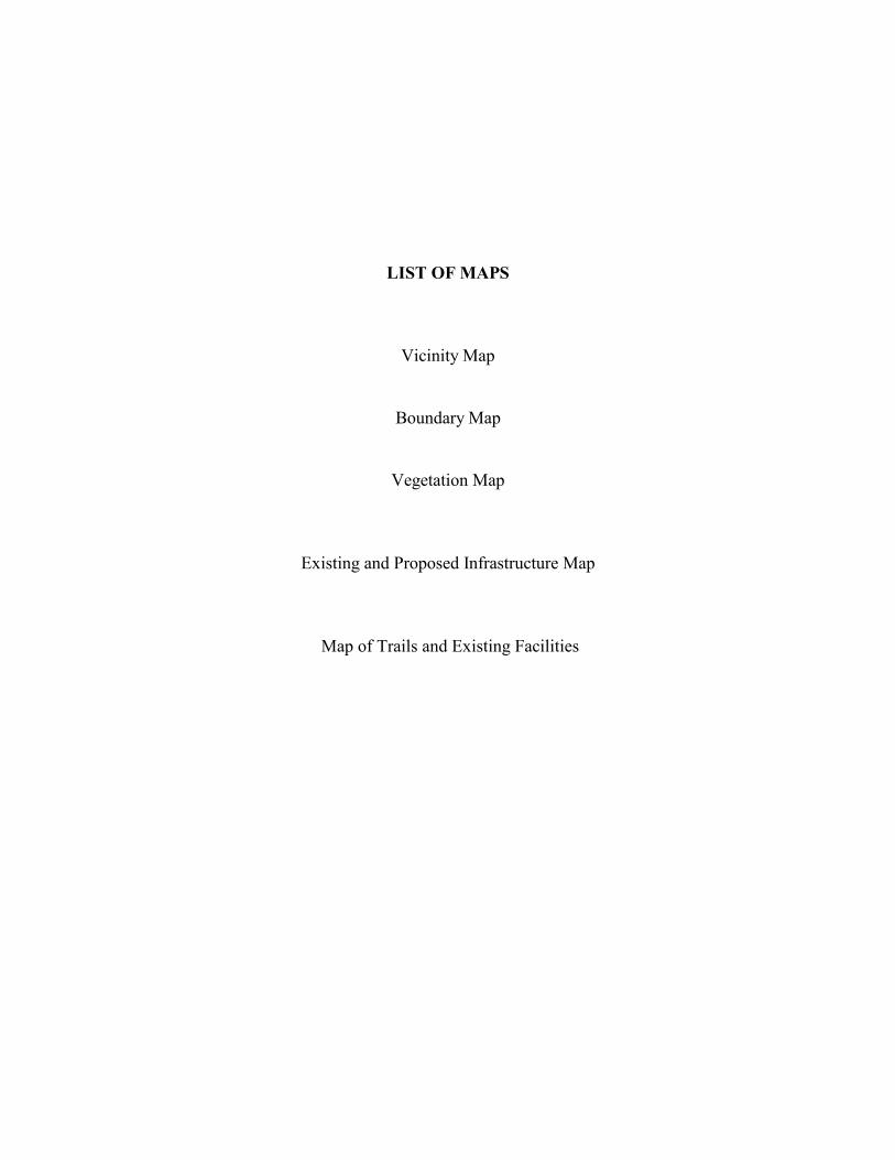
LIST OF MAPS
Vicinity Map
Boundary Map
Vegetation Map
Existing and Proposed Infrastructure Map
Map of Trails and Existing Facilities
1
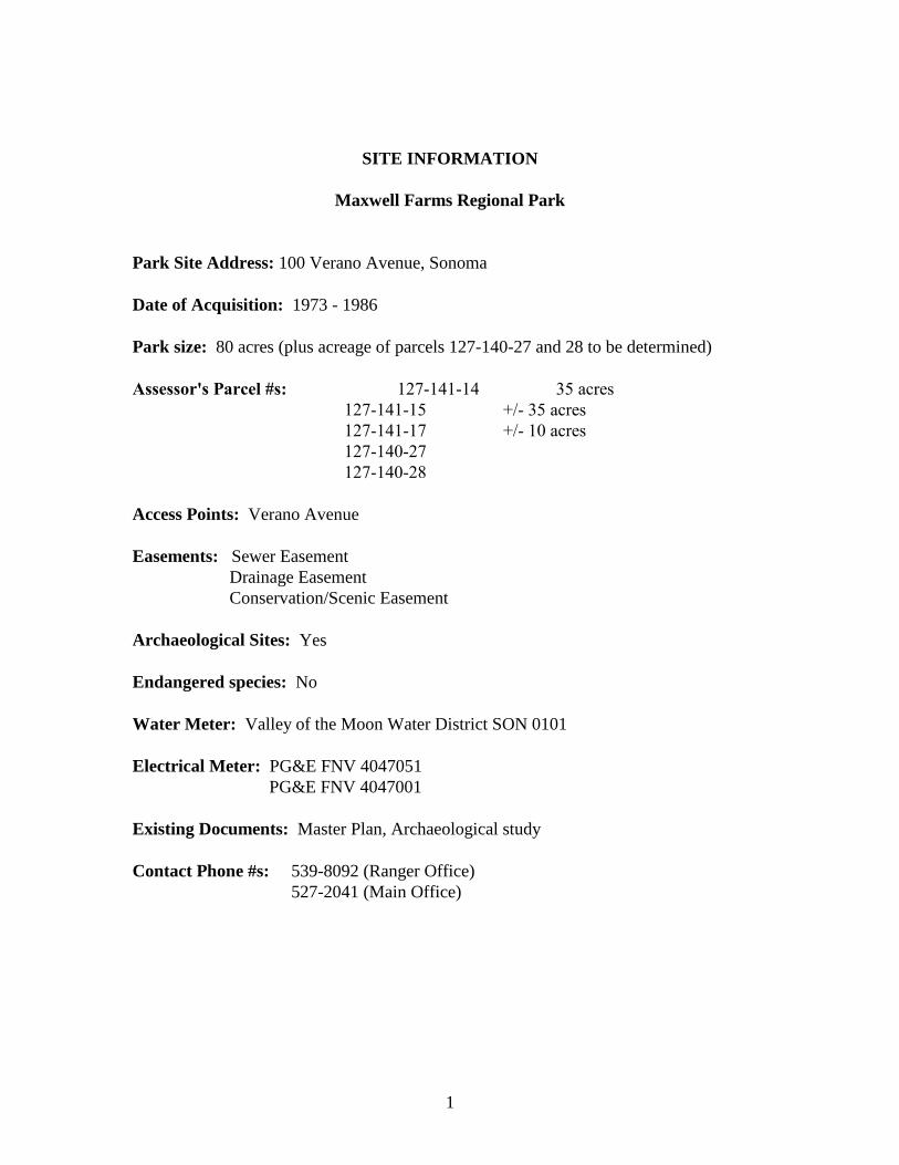
SITE INFORMATION
Maxwell Farms Regional Park
Park Site Address: 100 Verano Avenue, Sonoma
Date of Acquisition: 1973 - 1986
Park size: 80 acres (plus acreage of parcels 127-140-27 and 28 to be determined)
Assessor's Parcel #s: 127-141-14 35 acres
127-141-15 +/- 35 acres
127-141-17 +/- 10 acres
127-140-27
127-140-28
Access Points: Verano Avenue
Easements: Sewer Easement
Drainage Easement
Conservation/Scenic Easement
Archaeological Sites: Yes
Endangered species: No
Water Meter: Valley of the Moon Water District SON 0101
Electrical Meter: PG&E FNV 4047051
PG&E FNV 4047001
Existing Documents: Master Plan, Archaeological study
Contact Phone #s: 539-8092 (Ranger Office)
527-2041 (Main Office)

2
INTRODUCTION
This park Resource Management Plan has been developed with the input of park
personnel familiar with the Maxwell Farms Park and has drawn extensively from the
existing Maxwell Farms Master Plan. It is intended to be a user manual to to set goals
and operating policies for the facility. The document is designed to be used as both an
informational and an operational handbook, and suggestions and improvements as to its
contents are encouraged. The recommended actions specified in this document were
agreed to by management, but may be modified upon approval if deemed necessary.
For ease of reference, each section contains a summary of recommended actions
which are compiled in a spreadsheet in the Appendix listed according to the
recommended time frame of the action.
3
SITE DESCRIPTION
Regional Setting
The Sonoma Valley is a long, narrow alluvial valley oriented in a northwest to
southeast direction located in the southeast portion of Sonoma County. It is bounded by
the Sonoma Mountains to the west and Sonoma-Napa Mountains to the east. These
mountains are covered with grassland and oak woodland and gradually diminish towards
the south near the town of Schelville. The valley is bissected by Sonoma Creek which
originates near Hood Mountain and discharges into the San Pablo Bay. The City of
Sonoma is the principal urban center of the region.
Tourism is popular in the area, both because of the historic Spanish heritage and
the many wineries. The area is readily accessible along Hwy 37 from the Bay Area and
Sacramento and along Hwy 128 from the west and north. Population growth has been
moderate but steady during the twentieth century. The highest percentage of retired
persons in Sonoma County live in the Sonoma Valley. Growth is likely to continue to be
steady in the area.
Project Setting
The Maxwell Farms Regional Park is located between the City of Sonoma and the
unincorporated community of El Verano/Boyes Hot springs/Aqua Caliente. It comprises
85 acres of the southwest quadrant of the Highway 12-Verano Avenue intersection. It is
surrounded on all sides by existing or proposed commercial and residential development.
The western boundary of the park is Sonoma Creek close to the confluence with Agua
Caliente Creek. Several hot springs are located nearby. Sonoma Creek is designated as a
major riparian corridor in the Sonoma County General Plan and Highway 12 as a scenic
corridor
The site recognized as being important to the community in serving as 'a buffer
"greenbelt" and visual corridor'. It is zoned as Public Facility. The park is also referred
to in the City of Sonoma's General Plan as important to use as public facilities, both
because of its geographic location in the valley and its role as an open space link between

4
Sonoma Creek and the nearby hillsides. The site has recently been proposed for removal
from the sphere of influence of the City of Sonoma in the draft Environmental Impact
Report for the General Plan update (Wagstaff and Associates, 1995). The city boundaries
would remain on the boundary of the park.
The park is composed of two units, the eastern one-third is slighly higher in
elevation and is part of an old terrace deposit characteristic of the majority of the land
surrounding it. The western two-thirds is a more recent alluvial terrace which is part of
the river's flood plain. This terrace is bissected by three old meander channels which
have largely filled in with sediments. Vegetation is composed of a mosaic of grassland,
oak savanna, riparian wood, and ornamental plantings.
5
GOALS FOR MAXWELL FARMS PARK
General Goals
The general goals of the Sonoma County Regional Park Department in the
operation of parks are as follows:
1. To provide appropriate regional park recreation opportunities and facilities for
children, youth and adults which are in keeping with the dedication agreement and
resource capabilities of the site.
2. To preserve and enhance, where appropriate, the natural resources, open space
and wildlife habitat values of the site.
3. To provide for the management and operation of the park in a safe, healthy,
efficient and cost-effective manner.
4. To promote prevention of anti-social behavior of children and youth.
Management and Operation Goals
These are derived from discussions with park management staff and agencies with
jurisdiction over the park.
1. Public Safety: The public shall be provided with a safe environment for
recreational activity.
2. Public Access: Vehicles other than park maintenance vehicles will be
restricted to the parking lot. The SCRPD is undertaking any work necessary to conform
to Americans with Disabilities Act (ADA) requirements.
3. Park Boundaries: These will be clearly identified.
4. Natural Resources: Care shall be taken to preserve the natural resources within
the Park when possible.
5. Management Plan update: There shall be regular review and update of goals
and actions of the management plan.
Community Goals
Recreational programming goals were identified for Maxwell Farms Park
following a ten-month period of community attitude survey research using newspaper

6
articles, public meetings and smal group conversations. The following five social goals
were identified from this process:
Recreational cultivation
Exercise and Athletics
Cultural Expression
Hospitable access
Conservation Education
These goals have been instrumental in guiding the direction of developments at
Maxwell Farms Park and will continue to be important in future planning efforts.
However, community support is important in implementing park activities if these goals
are to be more fully realized.
Management Plan Goals
In addition to the general goals of the park, the various elements of the
Management Plan shall contain a summary of goals in the form of specific actions. These
shall be designated as either ongoing or with a specific time period as follows:
0 - Ongoing maintenance action
1 - Action recommended within the next two years
2 - Action recommended in the next three to five years
3 - Action desirable when resources are available.
The specific recommended actions shall be reviewed annually after an inspection
and report is made of the property.
Goals of George Maxwell
George Maxwell's stated goal was for each family to be self-sufficient on the land
in a "homecroft". His family therefore donated the property to the Natural Food
Associates which had a strong interest in conservation, organic gardening and the
operation of a model farm.
Future Goals for Maxwell Farms Park
There have been numerous projects and activities proposed for the park, and a
number of these were included in the adopted Maxwell Farms Park Master Plan.
However, the Sonoma County Regional Parks Department (SCRPD) does not have
sufficient financial resources or personnel to manage activities beyond the usual park
maintenance. If, therefore, additional activities or projects than those currently in

7
existence are to be approved for Maxwell Farms Park, they will need to be organized and
administered by an outside entity who will take responsibility for the activity and the
costs involved.
Possible projects at this time are the construction of a Boys and Girls Club within
the park boundaries, a skateboard park, creation of a Sonoma Ecology Center research
building and the development of demonstration agricultural projects. Issues to be
resolved in the future concern the use of the strip of land on the other side of Verano
Avenue, as well as the removal of exotic plant species along Sonoma Creek. Any changes
to the existing Master Plan will be approved by the Board of Supervisors and the
necessary CEQA environmental documents undertaken before the projects are
undertaken.
It is to be remembered that, while the Regional Parks Department shall make every
effort to implement the recommended actions proposed in this Management Plan, there is
no guarantee that all or any of them (except those required for maintenance) will be possible
unless funding and resources are available.

8
OPPORTUNITIES AND CONSTRAINTS
Maxwell Farms Park presents a number of opportunities for both recreational and
educational activities in an area which is rapidly becoming more populous and the park
amenities more in demand. The park is also becoming increasingly important as an urban
separator. At the same time, however, the adjacency to urban centers must be considered
a constraint since the park will be subject to heavy use and difficult to protect from
vandalism and undesirable uses such as drug and alchohol. The major factors considered
as either a constraint, an opportunity or both are listed below:
Size and location of park
Perhaps the most important opportunity that this park offers is the adjacency to
urban areas and its function as a buffer zone of open space. Although not a large park
compared to other parks operated by Sonoma County Regional Parks Department, it is
easily accessible by road and almost all of the acreage is useable for a variety of purposes.
The value of these assets will only continue to increase over time and careful planning
will ensure that these benefits are used to the best advantage. The potential negative
impacts of proximity to urban ares (vandalism or illegal uses of the park) can be
minimized by preventative measures.
Soil Fertility
It should be noted that much of the soil in the park is considered to be Class I soil,
making it productive for a range of crops. This would seem to present a unique
opportunity to develop a model garden/farm which could be a part of the school
educational activities and at the same time fulfil the goal of George Maxwell to create a
'homecroft' in the park.
Erosion
This can sometimes present a constraint to the use of a park when the terrain is
steep and the roads and trails are used by a variety of traffic. At Maxwell Farms Park,
however, there is little overall threat of erosion since the topography of the park is
extremely level and there is substantial vegetation cover. In addition, there has been little

9
soil disturbance from past agricultural activity, enabling the soil to maintain its structure
and therefore its percolating ability. This in turn, reduces the risk of excessive runoff
during heavy rainstorms. The only areas of concern are some of the creek locations
where the banks are steep and the creek current is undercutting the bank. There is also
the possibility of erosion occurring where minor, unofficial trails have cut down the
banks to the creek.
Natural Hazards
There are no major constraints on the park due to the likelihood of natural
catastrophes such as earthquakes, floods or wildfires. There is the possibility of these
occurring, but the event would have to of major proportions to substantially affect the
park
Adjacency to mobile home park and other residences
There could be some impact on neighbors of the park due to noise, lights and
intrusion of privacy of some activities, primarily those held at night. This is not a
problem at this time and is not anticipated with the existing park activities, with the
exception of present unauthorized activities in Wayside Park which have caused some
complaints from the residents of the FAHA apartment complex.
River
Several portions of the river bank are steep and dangerous and efforts at fencing
them off from the public have been only moderately successful. While access to the river
is desirable, it should be considered an opportunity only where it is safe to have a suitable
path and those areas that present a hazard need to be carefully protected.
Swimming hole
The section of the river used as a pool for swimming has been a popular public
spot since prior to the creation of the park, and it is easily accessible from Riverside Drive
as well as from within the Park itself. Obviously considered an opportunity by those who
bathe there, it must be included as a liability for the park unless it can be placed outside
the park boundary or restricted from use. The access on both sides is steep, there is a
mud slide that has been created for use into the river and several large boulders around
the perimeter of the swimming area.

10
Multiple-Use park
Although not a large regional park, Maxwell Farms Park already serves a diversity
of purposes, and this is likely to increase as the cultural and educational components
become developed. While this is a real opportunity, care should be given as to how these
different activities are developed so that they do not conflict. There appears to be
adequate space for separate activities (recreational, gardening, natural resources), but the
size of the park is actually quite small and must therefore be carefully designed.
Man-made hazards
The proximity of urban areas to the park will pose some constraints in the
increased possibility of man-made hazards and only Spring Lake Regional Park has had a
higher level of incidents and repair costs. Incident reports for the past five years show
some increase in park incidents. There is also a change in the type of incident, with a
decrease in graffitti incidents and an increase in vandalism, particularly lock cutting of the
service road gate. Fire is particularly likely in the undeveloped portion of the park. Fire
incidents (all small fires) have remained approximately the same with between 1 and 4
fires in a three-month period. Since fire safety precautions are observed in the park,
however, the danger is not unduly significant, and the area is well-served by fire and
ambulance service should an emergency occur.
Wayside Park
When developed for suitable uses, this portion of the park (see infrastructure map)
could be an asset, but in its current condition it is both a liability to the SCRPD and a
nuisance to the neighbors. Both the residents at FAHA and the adjacent property have to
cross Wayside Park to access their properties.
Deed Restrictions
There exists a 12 - 15’ wide sewer easement from the shopping center to the main
sewer line bissecting the park and a drainage easement 75’ in width on the southwest
corner of the park to Sonoma Creek. There is also an existing conservation/scenic
easement created between the Board of Supervisors and the Natural Foods Associates that
bissects the park and protects the southern portion of the park from development other
than agricultural activities.

11
HISTORICAL SUMMARY
Maxwell Farms Regional Park is named for George Herbert Maxwell. The
property had been in the ownership of the Maxwell family from 1848 and the original
Maxwell home on the property had been destroyed by fire in 1945 (Stillinger and
Frederickson, 1977). George Maxwell became nationally known as the "Father of
Conservation" by virtue of his belief that life on the land was the highest principle of
human existance. He was instrumental in the passage of the Newlands Act whereby the
Federal Government planed and constructed irrigation projects. The projects were to
serve farms of less than 80 acres to encourage small scale farming and to prevent abuses
of land speculation.
His goal was to make each family self-sufficient on the land in a "Homecroft". A
croft was a small farm in Scotland and was a way of life whereby a family supplemented
an outside income with food raised on the family plot.
By reason of the Maxwell family's interest in this unique form of agriculture,
George's son Donald gave the property to Natural Food Associates in 1968. This non-
profit association, based in Illinois, sold the property to the SCRPD.
Approval for County acquisition of Maxwell Farms Park began in 1973, but
acquisition of all the parcels was not completed until 1986. The park was dedicated on
May 21, 1988. The original Park Master Plan was approved in 1986.
12
PUBLIC USE
A population of 9,100 people is projected for the Boyes Hot Springs/Sonoma area
for the year 2000. Many of these people are within easy access to the park and can walk
or bicycle. The highest use of the park is on the weekends, but there is activity throughout
the week.
Use of the Park
The park may be used by the public between the hours of 8 a.m. and sunset and
subject to abiding by the local, County and Regional Park regulations that are applicable
to the park. Use of the park shall only be curtailed by the risk of public endangerment or
specific organized and/or reserved activities within portions of the park.
Use Levels
Current use levels of the park are recorded at 133,261 vehicle use of the parking
lot for 1993/94, a decrease of 34,119 from the previous year. This does not accurately
reflect the use of the park, since the park is easily accessed by neighboring residents on
foot. The major use of the park is on weekends, although there is steady use during the
week also.
Public Access
The main public access, off Highway 12 has parking presently for 88 vehicles in
the parking lot. The public may also access the park on foot or bicycle from the bridge on
Verano Avenue.
Limited Access
Only vehicles authorized by the Regional Parks Department may enter the park
beyond the picnic area. There is a gravel road up to the ranger's residence and most of the
major trails are wide enough to permit vehicle use. All major portions of the park are
accessible by vehicle.
13
Use Areas
The major use areas are the paved trails and the picnic area. The rear portion of
the park is used by bicycles and joggers, but otherwise currently is little used. Further
development in this area might discourage less desirable activities from taking place.
Permitted Uses
Recreational Activities: The major use of the park is for active recreation, and it
is anticipated that such use will increase with the recent opening of the Little League
field.
Equestrian Use: Horses are permitted within the park, but there are no
specifically designated trailer spaces for parking, and horseriding activities are limited
since the park is less attractive for this activity than other parks nearby and only has
approximately 40 acres available for use.
Bicycling: Bicycling is permitted within the park on designated trails. It is
proposed by Caltrans to include the addition of a bicycle lane cantilevered off the bridge
on Verano Avenue in future road improvements. This would improve access to the park
for bicyclists and increase park traffic. Consideration will, therefore be given to the
development of a suitable multi-use trail that will be used as a connection between
Verano Avenue and Highway 12.
Educational Uses: The Adopt-A-Watershed program currently uses the park for
field trips to learn about creek ecology, and is interested in undertaking creek restoration
activities such as tree planting. It is anticipated that the park may be used for additional
educational purposes in the future.
Restricted Use
Hunting and Fishing: No hunting shall be allowed in the park, but fishing is
permitted in the creek all year, subject to Fish and Game Regulations.
Swimming: The SCRPD does not authorize the use of the Creek for swimming.
Restriction of Use: The operation and maintenance level of service for Maxwell
Park are dependent on adequate funding from the County and fund-raising activities.
User expectations for a high degree of services may not be met due to limited funds for

14
operations. In addition, the park may be closed due to extreme weather conditions such
as high winds, heavy rains or critical fire danger.
Present Uses
Recreation Areas: These include multi-use fields, Little League field and tennis
courts. There are also a basketball practice area, volleyball courts and a play area These
may be used by the public when available or by reservation. Posted rules for the use of
these areas must be observed.
Trails: Use of the park trails shall be on foot, bicycle or horseback. Permitted
uses of the park roads and trails shall be posted by signs. All park users are expected to
read the park use regulations posted in the parking lot and to follow the required etiquette
for specific uses of the park facilities. Additionally, disabled persons shall be permitted
wheelchair access to the picnic area and the trails that are suitable. Off-road vehicles
(ORVs) are not permitted access. Dogs shall be permitted when kept on a leash.
Picnic Areas: There is seating capacity for a maximum of 100 people in the
group picnic area which may be reserved for use by contacting the Regional Parks
Department at (707) 527-2041. There are additional tables at the playground area and
adjacent to the playing field and more tables will be available shortly.
Creek Area: Recently the Adopt-a-Watershed program that operates in several
schools near the park has begun bringing children to the creek for educational purposes.
Proposed Uses
In addition to the above, the Master Plan recommended the establishment of a
horse arena, ampitheater and model farm/garden. These will not be developed unless a
suitable organization undertakes them and submits a specific proposal to the SCRPD by
the time of the revised Master Plan which will be reviewed during the coming year.
Projects with Funding
The Sonoma County Board of Supervisors recently approved funding towards the
construction of a Boys and Girls Club from money allocated from Community Youth
Partnership program funds. It is proposed that this structure be in the portion of the park
between the Little League field and the playground/ picnic area (see infrastructure map).
The Sonoma Boys and Girls Club would be interested in securing the remaining funds

15
necessary. This building could be designed so as to be unobtrusive from view, and would
have suitable parking and access. There is also an existing sewer line and utilities nearby.
A design for the structure is being developed.
The Sonoma Skateboard Society has also secured funding for a skateboard park
that could be located adjacent to the proposed Boys and Girls Club building.
Other proposed projects
Picnic area: Additional picnic tables are to be provided in the park and it has
been suggested that a second group picnic area could be established adjacent to the Little
League field which would relieve the overcrowding at the present site.
Agricultural Activities: Some interest has been expressed by the Sonoma Ecology
Center to expand the Community Agriculture Project to include activities at Maxwell
Park. These would be complementary to those undertaken at the existing 6-acre Pauline
Bond Community Farm in east Sonoma. At this time there has been a commitment to a
future involvement, but no specific funding or plan has been identified.
Research Center: The Sonoma Ecology Center has requested to develop a
Riparian Station Research Center which would house research equipment and provide
materials and possible space for lectures and exhibits on the creek. The proposal is to
locate a building adjacent to the creek in the Wayside Park area (see infrastructure map),
possibly a portable classroom unit initially.
Wayside Park: In addition to the possiblity of the Research Center site, it is
proposed that the Wayside Park could be landscaped so as to prevent unecessary use of
this area and to address complaints from the neighbors. Inquiries will be made to
establish a formal arrangement with Paul's Little League field to permit continued parking
on SCRPD property but so as to limit liability and to reduce the dust that is generated
from this use. The possibility of a lease to FAHA will also be investigated.
Creek Area: Adopt-a-Watershed has expressed an interest in undertaking
riparian replanting with the local school children. The Sonoma Valley Watershed
Council would also be interested in establishing a Sonoma Creek interpretive trail

16
GEOPHYSICAL CHARACTERISTICS
This section provides a brief description of tbe physical characteristics of
topography, climate, geology and soils.
Geology
There is a concealed earthquake fault trace passing through Verano Avenue east
of the park. There is inconclusive information as to the actual location and activity of this
fault trace. The area is subject to seismic shaking due to deep unconsolidated alluvial
deposits. The closest known potentially active earthquake fault is the Rodgers Creek
Fault located approximately 5 miles to the west (Terry, 1980). Activity of this fault may
be associated with the Healdsburg Fault although the linkage between the two faults is
uncertain. The Healdsburg Fault is associated with the Santa Rosa earthquake
(magnitude approximately 5.6) of October 1, 1969. Damage in the Sonoma area was
primarily a result of seismic shaking rather than fault rupture. This project is not within
an Alquist-Priolo Fault Hazard Zone.
Topography
The land is relatively flat with undulations created by the river terraces. Slopes
range between 0 - 9%. The elevation varies between 80 and 140 MSL with the highest
portion being located at the eastern third of the park.
Soils
Soil types occurring in the area are Tuscan cobbly clay loam (TuC) and Zamora
silty clay loam (ZaA). Permeability of these soils is slow to moderately slow. The Soil
Conservation Service rates these soils as Capability Class I for the Zamora which are the
highest fertility soils and can be used for orchards, vineyards, pasture and row crops. The
Tuscan soil is rated as a IVe-3, suitable primarily for range though vineyards can be
grown where the soil is of sufficient depth. Erosion potential is slight to moderate, with
the Tuscan soil being the most prone to erosion.
Over 50% of the park consists of the Zamora soil, predominantely along a 1000 ft
strip beside the creek.

17
Climate
Warm, dry summers are moderated by the sea breezes from the marine layer
moving onshore from the San Francisco Bay. Winters are mild and rainy with an average
of 28.08 inches of rain annually. Low clouds or fog sometimes extend inland to the site
during the summer months

18
HYDROLOGY
Summary of Recommended Actions
* Focus access to creek (1)
* Develop official creek access trails (1)
* Improve creek bank safety (1)
* Review creek bank stabilization measures (3)
* Develop an interpretive trail (3)
* Remove erosion netting where it is exposed on creek banks (1)
_____________________________________________________________________
Watershed
Maxwell Farms Park is located in the Sonoma Creek and Fryer Creek watersheds
in the Valley of the Moon, as delineated in the Sonoma Drainage Master Plan by the
Sonoma County Water Agency (1978).
Sonoma Creek
The source of the Sonoma Creek is in the Mayacamas range between Napa and
Sonoma and it is a perennial stream. There are two areas in the western portion of the
Park where Sonoma Creek has been actively undercutting its bank and widening its
channel. No riparian vegetation grows on these near-vertical banks. Bank stabilization
would involve placing riprap at the base of the bank and possibly rerouting the creek to
the center of the bed away from the bank. Severe undercutting is occurring on the
western portion of the creek bank which is adjacent to private backyards. No structures
are in immediate danger, but it is likely that this process will continue unless the
watercourse can be modified or the banks reinforced. An investigation will be undertaken
as to what remedial action is possible to deter this undercutting.
Surface Water Runoff
The park at full buildout was estimated in the Master Plan to generate
approximately 14.5 cfs runoff according to calculations based on the proposed
impervious surfaces. The amount of actual paved surface for roads, parking and playing
courts is less than this. The proposed mitigation for this runoff was to direct it toward

19
existing onsite swales. In the southern end of the park, swales were recommended in the
1986 Master Planneed to be contoured into the land to take runoff in order to prevent
flooding on the adjacent mobile home park. The Water Agency has confirmed this
method of handling runoff. However, this has not proved necessary to undertake at this
time.
Flood Danger
Sonoma Creek presents no significant flood hazards to the project area according
to the Sonoma County Water Agency.
Creek Access
The SCRPD has created a walkway to the creek which is a safe access, and it is
recommended that creek use be focused in this area, and other access paths discouraged
with the possible exception of the northern portion. Review of measures to limit creek
access will be undertaken and may include posting signs and improving fencing along the
creek.
Creek Banks
The SCRPD has undertaken contouring on a portion of the creek bank in recent
years and this area has been held in place with erosion netting while vegetation
re-establishes there. This netting is supposed to degrade with sunlight, but has not yet
done so and removal of exposed portions will be undertaken in the near future. Some
areas of the creek would benefit from a tree planting program and the Adopt-a-Watershed
program has expressed interest in planting trees with schoolchildren if the trees were
provided. There is also interest that has been expressed by the Sonoma Valley Watershed
Council to help develop an interpretive creek trail which could be established along the
creek banks for educational purposes.

20
ARCHAEOLOGY
Archaeological site locational information is considered confidential and survey
details conducted within the parks are kept on record at the Regional Parks office at
County Center Drive. In order to prevent the spread of information which may lead to
vandalism, such information may be made available only to qualified archaeologists,
agency officials and authorized personnel. All permanent park staff are sworn to
confidentiality not to divulge archaeological information to the general public. In
addition, state law provides that no person shall remove, deface or excavate any contents
on historic and prehistoric ruins on public lands (Section 5097.5 of the California State
Resources Code). Violation of this section is a misdemeanor.
Many of the parks in Sonoma County have historic or prehistoric remains that are
a part of the cultural history of the area and are important to protect from disturbance to
the extent possible. The Regional Parks Department undertakes monitoring of these sites
and other protective measures as needed. Conserving such areas in their original location
is made possible by the protection offered within the parks where construction is
minimal. In due course, it is hoped to provide a display of the artifacts that have been
found in different park sites at the Spring Lake Visitors Center. A cultural historical
background of the indians and early settlers who used the various locations in Sonoma
County would also be provided so that park visitors may become more familiar with the
local history.
An archaeological investigation was undertaken for Maxwell Farms Park in 1977
by Robert Stillinger and David Frederickson of Sonoma State University. One
previously recorded prehistoric site was not located (possibly outside the park
boundaries) and one new prehistoric site was found but no artifacts were present. The
site of the previous Maxwell home has been mapped and recorded. Both sites are eligible
for placement in the National Register of Historic Places. Reference must be made to the
archaeological documents before any structural work or ground disturbance is undertaken
within the park.

21

22
VEGETATION
Summary of recommended actions
* Thin out or remove understory/old vegetation (0)
* Protect wildlife/vegetation along creek (0)
* Maintain 50' development-free buffer zones along each band of riparian vegetation (0)
* Replace oak trees as needed (0)
* Develop a long-range tree management program (2)
* Coordinate volunteers’ work days with the Sonoma Ecology Center (0)
* Removal of exotics by Park staff and volunteers (0)
* Establish clearing standards (1)
* Revegetate creek banks where needed (1)
________________________________________________________________________
Site botanical surveys were conducted in 1983 and 1984 which form the basis of
the following report except where noted. Vegetation on the site was described by the
survey report as a mosic of grassland, oak savanna, riparian woodland, eucalytus grove
and ornamental plantings. Remnants of old plum orchards still exist in the meadow areas
(see Vegetation Map).
Grassland originally covered the majority of the project site. As is true for the
topography of the site as a whole, it can be divided into two units. The upper bench was
originally covered entirely by grassland. The soil was poorly drained and supported a
sparse stand of grasses and broadleaf herbaceous species. Grazing pressure from horses
has been heavy in the past and few preferred browse species were in evidence at the time
of the field survey. Dominant grasses were annual species such as wild oat. Several
broadleaf herbaceous species which are not preferred browse formed the dominant plant
cover such as turkey mullein, tarweed and gumplant. Part of the area has since been
drained and covered with turf, parking lot and recreational facilities.
The grasslands on the lower alluvial terrace support a denser stand of annual
grasses and forbs. Grazing pressure has been lighter here and the soil is better drained.
Portions of this area have been used in the past for growing orchard crops. The eastern

23
portion of the park which had not been grazed, yielded a large variety of native and
introduced wild flowers at the time of the survey. A list of these species is presented in
the Appendix.
Oak Savanna is found along the slope which joins the upper and lower terraces.
Valley oak forms the tree cover and it has an annual grassland understory. Species
composition of the grassland is similar to that described for other grassland portions of
the site. The savanna occupies only a small area in the south central portion of the project
site.
Riparian woodland forms two distinct associations on the project site. The old
stable stream channels which cross the alluvial terrace are lined with dense stands of large
trees. California bay is the dominant species, with valley oak also forming an important
part of the stand. Other tree species found in this woodland include California buckeye,
Oregon ash, coast live oak and bigleaf maple. Shrub and herbaceous understory species
are largely lacking except for the occassional occurrence of snowberry. California grape
intertwines the trees in several locations. The riparian woodland in the western portion of
the park contain typical native plant species including California bay, willow, valley oak,
bigleaf maple and Hinds walnut.
The banks and gravel bars of Sonoma Creek are lined with a second type of
riparian woodland. Here several fast growing deciduous tree species with a high water
requirement dominate. These include white alder, Fremont cottonwood and red willow.
Shrubby willows including arroyo and sandbar willow are also common. These species
are able to rapidly colonize areas which have been swept clear of vegetation and are able
to maintain themselves during periods of high winter flow. This vegetation type is
limited to the immediate vicinity of the stream bed.
Ornamental Species have been planted in the vicinity of the park entrance and
surrounding the developed area of the park since the surveys were conducted.
Rare or Endangered Species
No rare or endangered plant species were observed during the initial site survey
nor have they been recorded to occur.
Vegetation Management
Maxwell Farms Park offers an unusual and striking contrast between a managed
park in the front portion and a relatively undisturbed natural area in the remainder of the
park. The vegetation management practices will be reflected accordingly. The majority
of the park personnel’s time will usually be spent on lawn maintenance, irrigation and
landscaping in the managed area. The undeveloped portion of the park does not require
intense management in its current state, but there are nonetheless some vegetation
24
management issues that need to be addressed before the invasion of several exotic species
becomes too rampant. The major concerns are with the following species:
Arundo Donax
The banks of the Sonoma Creek are becoming infested with Arundo donax, a
bamboo-like rush that originated along the Nile in Eygypt. At this time, the only known
treatments are mechanical pulling (the roots can extend to a depth of 10 ft or more) or
chemical treatment. The chemical treatment is not desirable in a riparian area, and the
alternative is for work groups to cut and pull existing stands before they become more
established. The Sonoma Ecology Center organized such a work day last summer in the
upper reaches of the park property, and is prepared to continue such efforts. However, it
may be a suitable task for other volunteers to undertake also, since every part of the stem
can establish and it is important to act aggressively before the task becomes impossible.
Scotch Broom
While not quite so problematic yet as the Arundo donax, this plant propagates
rapidly, and will form a dense mat if permitted to become established. Mechanical
pulling is effective, but must be done thoroughly and for several years. This plant is also
established primarily along the creek banks.
Himalyan blackberries
Some clearing of an extensive patch of blackberries was undertaken last summer
and it is recommended that such efforts will be continued as often as possible. Many of
the sites containing these blackberry bushes are still confined to a small area but will
spread if not discouraged.
Understory clearing
With the increase in the possibility of unlawful use of the understory of wooded
areas of the park, the Regional Parks Department is undertaking a trimming program to
clear the understory to a height of 5 or 6 feet. Tree clearing guidelines will be established
for this program, which will be incorporated into the long-range tree management
program which is being developed for each park.
Protection of Vegetation Habitat
Except for the removal of exotics, vegetation in the riparian corridor will be
protected and maintained unless considered a hazard. Mitigation measures in the 1986
Master Plan prohibit any development or improvements except for recreational trails
within a 50’ buffer zone from the dripline of each band of old growth riparian vegetation.
Revegetation
Erosion is minimal in the park except along the creek bed, and revegetation is
recommended particularly in the area that was recently graded by the SCRPD (see

25
Vegetation Map). The Adopt-a-Watershed program that works with several of the local
schools has offered to undertake tree planting if SCRPD can obtain the materials needed.
The area will be cleared of exotics prior to such efforts.
Landscaping
No major landscaping is anticipated (except as a result of new construction), but
some landscaping might be undertaken in Wayside park.

26
WILDLIFE
A field survey of the Maxwell Farm was conducted by prior to the initiation of
the park and the following is extracted from the report (Larry Seeman Associates, 1980 ).
It was noted that wildlife on the project site is found in association with the vegetation
types that are present. An animal may utilize several vegetation types or be restricted to
just one, depending on its habitat requirements. Bird species are frequently closely
associated with single habitat types, while mammals will more often move between
several.
The grassland areas serve as important hunting and feeding areas for a variety of
species as well as being the principal habitat for a more limited number of small birds and
mammals. They support populations of small rodents including botta pocket gopher and
western harvest mouse. Blacktailed jackrabbits are also common in the grassland. Small
bird species found in the grassland include western bluebird, red-winged blackbird,
western kingbird and lark sparrow. These species serve as a prey base for a variety of
predators. These include resident raptors such as the American kestrel, red-shouldered
hawk, and great horned owl. Mammalian predators which hunt in the grassland include
striped skunk and grey fox.
Many species use the grassland for only part of their habitat requirements. They
move between the grassland and other habitat types, generally using the grassland to feed
or hunt and seeking cover in other vegetation types. The majority of the predators
mentioned above exhibit this behavior pattern. Other species which also engage in this
pattern include California quail, scrub jay, house finch, brown towhee and black-tailed
deer.
The oak savanna is a transition habitat type between the grassland and woodland
habitats. Because of this it supports wildlife from both habitat types. Virtually all
grassland-associated species are found in the savanna. Woodland species found in the
savanna are primarily bird species which are dependent on oaks. These include acorn
woodpecker, plain titmouse and white-breasted nuthatch. Predatory birds commonly use
the scattered oaks as hunting perches or roost sites.
The stands of riparian woodland lining the old stream channels and along the
upper banks of Sonoma Creek support a diverse range of wildlife species. This is due to
the type and structure of the vegetation. Plants such as wild grape produce abundant food
crops. Others, such as bigleaf maple and Oregon ash support large numbers of insects,
while the oaks supply both types of food. The vegetation itself provides escape, roosting

27
and nesting cover. Other factors which contribute to the diversity of wildlife species in
this habitat are the creation of the "edge" habitat and their use by animals as travel
corridors.
Common birds in the woodland include such resident species as California quail,
Nuttal's woodpecker, bushtit, white-breasted nuthatch and Hutton's vireo. Summer
residents found here include western flycatcher, warbling vireo and orange-crowned
warbler. Common wintering species include sharp-shinned hawk, hermit thrush, ruby-
crowned kinglet, and yellow-rumped warbler. Fall migrants include such species as
black-throated gray warbler, Townsend's warbler and western tanager. It is likely that
these stands of old growth riparian vegation provide suitable nesting habitat for red-
shouldered hawks. A pair was observed during the field survey and the vegetation found
here would provide optimum habitat for this species.
Mammals also make extensive use of this habitat type. Species closely associated
with it include opossum, broad-handed mole, gray squirrel and raccoon. Gray fox and
black-tailed deer make regular use of the vegetation corridors for travel and cover. Gray
squirrels were the most numerous species observed during the field reconnaissance where
they were seen foraging for acorns and bay nuts.
The ornamental vegetation is used by a variety of songbird species as well as
some small mammals. Bird species found here are primarily those commonly seen in
gardens and parks. Insect and nectar feeders may also be found.
The creek itself is home to a variety of wildlife and an observation in 1994 of 3
beavers (and four dams), 5 river otter and a 30 lb salmon was reported (Richard Dale,
personal communication).
Rare and Endangered Species
No rare or endangered wildlife species were observed at the time of the field
survey nor have they been recorded on the project site. It should be noted, however, that
other locations on Sonoma Creek support scattered populations of the California
freshwater shrimp (Syncaris pacifica). This species has been listed as endangered by the
both the State and the Federal Government.
Wildlife Management
No specific actions are recommended at this time and there are no observed
wildlife problems.

28
INFRASTRUCTURE
Summary of Recommended Actions
* Discourage access to Sonoma Creek from Riverside Road (1)
* Improve a trans-park bike route between Verano Avenue and Highway 12 (2)
* Update signage program with standardized park signs (1)
* Post park map and other relevant information on park notice board (0)
* Discuss with FAHA management improvements to FAHA entrance (1)
* Survey the property corners at Wayside Park (1)
* Regrade ditch and establish barriers at Wayside Park (1)
* Contact Valley of the Moon Little League to develop parking agreement (1)
* Review uses of the site adjacent to FAHA apartments (1)
* Relocate iron ranger (1)
* Revise Master Plan and prepare CEQA documentation for changes to existing Master
Plan (1)
* Repair/improve fencing along creek (1)
* Expand picnic areas (1)
________________________________________________________________________
Park Entrance
There is only one entrance to the park that may be used by all vehicles, which is
located at Verano Avenue near the Hwy 12 intersection. There is another access road
near the bridge on Verano Avenue which has a locked gate and awkward access but is
available for emergency use. Public Works would need to be contacted if this access was
to be used regularly. There is a pedestrian access adjacent to the bridge. There is
currently access to Sonoma Creek from Riverside Drive which the SCRPD may want to
prevent in the future. However, the proposed closure of Riverside Drive is likely to
reduce the traffic on that side of the creek.
Signs
There is a notice board located at the parking lot, but the cover has been removed
and there are no notices posted. A map of the park will be posted on this notice board
showing the locations of the trails, water faucets, telephone and activity areas. Additional
standardized park signs identifying trails and other park information will be established at
suitable locations within the park in the near future.
29
Roads
There is a paved road from the entrance on Verano Avenue to the parking lot area.
From the parking lot to the residence there is a gravel road. The remainder of the park
can be accessed by trails that are wide enough to accomodate a vehicle.
Trails
There is a paved path around the perimeter of the playing field, and another paved
path that extends from the parking lot to the backstop of the Little League field (See
Infrastructure Map). There exist a number of informal trails that have been cut through
the woods and down to the river. These will be discouraged where not appropriate and an
improved trail system developed. An improved bike trail crossing the park and
connecting the Verano Avenue bridge with the shopping area will be established for
access by bicycles and pedestrians once the bike lane has been added to the Verano
Avenue Bridge (see Infrastructure Map)
Parking
Currently there are 84 marked spaces for parking and 4 for handcapped parking in
the main parking lot. The parking capacity is considered adequate for future needs at this
time. The iron ranger at the entrance to the parking lot is inconveniently located
however, and will be relocated between the two entrance lanes on a landscaped median.
The height of the payment slot will also be adjusted to meet ADA requirements.
Wayside Park
This land was donated to the SCRPD by Caltrans and consists of a long thin
wedge-shaped portion of land on the other side of Verano Avenue adjacent to the FAHA
retirement complex (see Infrastructure map) It was initially proposed in the Master Plan
as overflow parking for the park, but additional parking for the park is not considered
necessary. The County Department of Public Works does not generally support the
location of mid-block crosswalks.
The site is currently not used for any approved purpose, although there is parking
here during the summer for Valley of the Moon Little League field. It has also been used
as a bus turnaround area. These activities generate complaints from the apartment
complex, and residents there have talked to the Department of Public Works who refer
the problem back to Regional Parks. The Department of Public Works would be willing
to re-establish the drainage ditch along the edge of the road if requested to do so by the
SCRPD which would discourage multiple entry points to this site.
A further complaint by one of the residents is that traffic travels too fast along
Verano Avenue and does not notice the entrance to the complex, making access
dangerous. This road is the preferred traffic route of motorists between Glen Ellen and

30
Sonoma and there have been three accidents at the site in the last few months according
to one FAHA resident. A discussion with the FAHA owners will be conducted in the
near future to decide on possible improvements to the entrance.
The appearance and the safety of the site could be greatly improved with some
minimal landscaping designed to form a barrier to vehicle access. A boundary survey of
the site will be undertaken to determining the extent of the Park's jurisdiction and
subsequent to this future uses of the site will be determined.
At the wider end of this wedge and adjacent to the creek, the property is suitable
for the construction of a building if this was consistent with SCRPD purposes and also
local zoning requirements. The Sonoma Ecology Center has expressed an interest in
constructing a research center at that location so as to have access to the creek. It is
suggested that the well house, recently offered to the SCRPD, might be appropriate to
include with such construction so as to be used and managed by the Ecology Center and
preserve local history at the same time. There might also be a possibility of a lease
arrangement with FAHA. Inquiries will be made with the Valley of the Moon Little
League as to their interest in developing a parking agreement with the SCRPD. Future
approved uses will be incorporated into the updated Master Plan.
Fencing
A chainlink fence separates the south of the property from the shopping center and
the mobile home park. A raised berm separates the park from Highway 12 on the east,
and there is some fencing along the creek at locations where access is deemed unsafe.
This fencing, however, has been circumvented to gain access to the swimming hole and
broken in other places, so alternative prevention will be considered
Picnic Areas
At present there is one group picnic area (see Infrastructure map) which is often
fully reserved. Another group picnic area is proposed at the north end of the Little
League field outside the dripline of the oak in that location. This site could be made
wheelchair accessible by extending the paved path behind the backstop. Another path
could connect directly to the parking lot. Water is already available at the site and a
barbeque pit could be established. Additional picnic tables will soon be available at
several locations throughout the park, beside the tennis courts and under the trees along
the playing field.
Buildings
A caretaker residence is located at the southern end of the park, and has
previously been the target of vandalism. That problem no longer exists however, and
31
currently the building is inhabited by the park caretaker. Other structures in the park are
limited to the restroom facilities at this time.
Proposed Structures
Any proposed infrastructure changes that are not consistent with the existing
adopted Master Plan will be reviewed at public hearings. Any changes to the Master Plan
will be formally adopted by the County Supervisors and a determination of impacts and
mitigations under CEQA will be made. The Management Plan will be updated to reflect
specific future actions for those proposals which are approved.
Playground
The Maxwell Moms organization raised $26,000 to construct this playground and
the area would require some additional fencing if the Boys and Girls Club building were
constructed in the location noted in the infrastructure map.
Recreational Facilities
There are currently two tennis courts, two volleyball courts, a basketball hoop, a
playing field and a Little League field. No repairs or improvements are anticipated for
these in the near future.
Water
Service is provided by the Valley of the Moon Water District from the Russian
River. The closest reservoir is located approximately 1/2 mile from the park. Drinking
water is available at the restrooms, picnic area, Little League field, tennis courts and
parking lot.
Sewer
The sewer line traverses the park (see Infrastructure Map) and is connected to the
restrooms and the residence.
Electricity
Electricity is provided by PG&E for the park facilities including a separate service
for the caretaker residence. A 12,000 volt distribution system and gas transmission line
are located along the northern boundary of the park along Verano Avenue and along
Highway 12.
Telephone
Service is provided to the park by Pacific Bell and there is telephone service
provided at the residence. There is a public telephone located at the restrooms.

32
EMERGENCY PROCEDURES
Emergencies may arise for several reasons, either caused by man-made or natural
circumstances. It is important that the Park staff are on the lookout for any that might
arise and take whatever actions possible to prevent them. If extreme weather conditions
exist, such as high winds or flooding or there is a danger of fire, the park may be closed at
the Regional Park staff's discretion. In such a situation, both the public and the Regional
Parks office needs to be notified with an approximate estimate of the duration of the
closure. Daily monitoring of the park trails and parking area will provide park staff with
the opportunity of checking for hazards or dangerous practices, such as the use of fire
within the park boundaries.
If an emergency arises, the appropriate department should be notified immediately
and information provided to the Regional Parks office. The following is a list of possible
emergency situations and the recommended procedures:-
Fire
The Valley of the Moon Fire District provides fire protection for the Boyes Hot
Springs area which includes the park. The Department operates two fire stations in the
vicinity, one at the intersection of Boyes Boulevard and Highway 12 and the other at
Arnold Drive. The Department has a mutual aid agreement with the Sonoma Fire
Department located approximately 2 miles from Boyes Hot Springs. There is also a
mutual aid agreement with the Division of Forestry for wildland fires.
A fire flow of 2,000 gallons per minute (gpm) is required for the project. Water
main sizes in the park are adequate to provide this capacity.
Most fires are caused by human activity and regular inspections for flammable
materials should be made during the fire season.
Insurance
The present Insurance Services Office (ISO) rating for the park is 3, with a
classification of 1 being the best and 10 the worst.
Accidents
Park ranger staff can administer first aid if they are present and the accident is not
serious. If more extensive medical treatment is required, the nearest ambulance service is
located at the Valley of the Moon Fire Department, less than 5 minutes away.

33
Earthquakes
No severe threat is anticipated in the park from earthquake activity, although the
Rodgers fault is located near the park. The area could however, be subject to seismic
shaking due to deep unconsolidated alluvial deposits.
Flooding
The park does not lie in the 100-year flood plain and no danger is anticipated from
flooding, according to the Sonoma County Water Agency.

34
OPERATIONS AND MANAGEMENT
Management Plan
This Management Plan has been developed in part to provide information for the
Master Plan update and it is anticipated that revisions will be necessary once the Master
Plan is adopted.
Hours of Operation
Maxwell Farms Park will be open from approximately 8 a.m. to sunset throughout
the year unless otherwise posted. The park may be closed when there are high fire danger
periods or other situations that could pose a threat to the health and safety of those using
the park.
Parking
Sufficient parking is provided in either the park parking lot or the overflow
parking lot across the street. A fee of $2 is charged each vehicle per day use and
Regional Parks permits are issued that are valid for use in any park. All vehicles are
expected to leave the park by the time of closing. Should a vehicle not be moved by this
time, the park staff may issue a notice of violation or a citation after reasonable attempts
to locate drivers. In
addition, park staff may take further appropriate action in accordance with the Regional
Parks Department's guidelines.
Park Patrols
The park facilities and trails are to be patrolled periodically for protection against
crime and vandalism, to enhance public safety and resource management and for the
detection of maintenance needs. This may be done by the department staff and/or
volunteers. The main trail should be patrolled at least once per day, and other areas
on an as-needed basis.
Patrol logs shall be kept by park staff which shall contain the time, date and
number of persons utilizing the facility. Maintenance needs, complaints from visitors and
other problems should also be recorded. Volunteers may assist in the foot patrol of trails,
interpretive services to the public and reporting maintenance needs or vandalism. Park
patrols shall not extend beyond the boundary limits of the park because they do not have
the jurisdiction to do so.
Law Enforcement
Park rangers shall enforce the county ordinances and all other applicable local,
state and federal laws. However, no employee shall offer assistance to a private party off
park property unless requested to do so by a public health and safety agency, or

35
in a life-threatening situation. All other situations must be promptly reported to the
appropriate health and safety agency. (See Department Law Enforcement Policy Duties
and Responsibilities).
Maintenance
Trails: Removal of hazards, repair/replacement of signs and fencing, pruning or
vegetation and maintenance of trail surface
Restroom/parking lot: Daily cleaning and restocking of restroom, inspection and
repair of directional signs, empty trash containers, inspect bulletin boards.
Roads: Maintenance of culverts by cleaning out as needed. Extensive repair or
replacement of park facilities shall be reported to the supervising park ranger.
Fee Collection
Appropriate day use and special use permit fees shall be collected at all facilities.
Maps/Signs/Interpretive Boards Maps of the parks shall be posted in prominent
places. Warnings of hazards should be clearly marked. The Park Operations division
maintains proper signage throughout the park. Such signs should specify key features
such as health and safety information to the public, designation of trail use and any other
information deemed necessary. Park staff must report and have replaced all damaged
signs immediately.
Use of Trails: Horse traffic and mountain bikes will be allowed on trails as
posted so long as such use does not cause significant negative impacts. If it is determined
to close a trail for a period of time, the trail shall be clearly posted. All use will be
restricted to marked trails, and gates should be kept locked. Dogs shall not be permitted
except on a leash.

36
BIBLIOGRAPHY
Department of Fish and Game. 1994. California Sport Fishing Regulations. Sacramento,
California
Larry Seeman Associates. 1980. Draft Environmental Impact Report, Maxwell Farm,
Sonoma County, California. Berkeley, California
Sonoma County Planning Department. 1978. The South Sonoma Valley Area One Study
Stillinger, Robert A. and David a. Fredrickson. 1977. An Archaeological Reconnaissance
of the Maxwell Estate, Sonoma County, California. Rohnert Park, Ca: Sonoma
State College
Sonoma County Water Agency. 1978. Sonoma Drainage Master Plan
Terry, B.V. 1980. Earthquake Faults of California. Van Nuys, Ca: Varna Enterprises
Wagstaff and Associates. 1995. Draft Environmental Impact Report for the proposed
City of Sonoma General Plan Update.