maximum station precipitation for 1, 2, 3, 6, 12, and 24...
TRANSCRIPT

U.S. DEPARTMENT OF COMMERCE SINCLAIR WEEKS, Secretary
WEATHER BUREAU F. W. REICHELDERFER, Chief
TECHNICAL PAPER NO. 15
Maximum Station Precipitation for
1, 2, 3, 6, 12, and 24 Hours
Part IV: Maryland, Delaware, and District of Columbia
DIVISION OF HYDROLOGIC SERVICES
HYDROMETEOROLOGICAL SECTION
In cooperation with
THE CORPS OF ENGINEERS, U. S. ARMY
WASHINGTON, D. C.
1954
For sale by the S4perintendent of Documents, U.S. Government Printing Office, Washington 25, D. C. • - - - - - - • - Price 25 cents
No.1.
No.2.
No.3. No.4.
No.5. No.6.
No.7.
No.8. No.9.
No. 10. No. 11.
No. 12.
No. 13.
No. 14.
No. 15.
No. 16.
No. 17. No. 18.
No. 19.
No. 20. No. 21.
No. 22. No. 23.
No. 24.
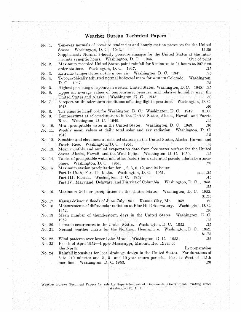
Weather Bureau Technical Papers
Ten-year normals of pressure tendencies and hourly station pressures for the United States. Washington, D. C. 1943. $1.50 Supplement: Normal 3-hourly pressure changes for the United States at the intermediate synoptic hours. Washington, D. C. 1945. Out of print Maximum recorded United States point rainfall for 5 minutes to 24 hours at 207 first order stations. Washington, D. C. 1947. .25 Extreme temperatures in the upper air. Washington, D. 0. 1947. .75 Topographically adjusted normal isohyetal maps for western Colorado. Washington. D. C. 1947. .75 Highest persisting dewpoints in western United States. Washington, D. 0. 1948 .. 35 Upper air average values of temperature, pressure, and relative humidity over the United States and Alaska. Washington, D. C. 1945. .50 A report on thunderstorm conditions affecting flight operations. Washington, D. 0. 1948. .40 The climatic handbook for Washington, D. 0. Washington, D. 0. 1949. $1.00 Temperatures at selected stations in the United States, Alaska, Hawaii, and Puerto Rico. Washington, D. 0. 1949. · .15 Mean precipitable water in the United States. Washington, D. C. 1949. .30 Weekly mean values of daily total solar and sky radiation. Washington, D. C. 1949. .15 Sunshine and cloudiness at selected stations in the United States, Alaska, Hawaii, and Puerto Rico. Washington, D. C. 1951. .15 Mean monthly and annual evaporation data from free water surface for the United States, Alaska, Hawaii, and the West Indies. Washington, D. C. 1950. .15 Tables of precipitable water and other factors for a saturated pseudo-adiabatic atmosphere. Washington, D. 0. 1951. .20 Maximum station precipitation for 1, 2, 3, 6, 12, and 24 hours: Part I: Utah; Part II: Idaho. Washington, D. C. 1951. each .25
.45 Washington, D. C. ~1953 .
. 25
Part III: Florida. Washington, D. 0. 1952. Part IV: Maryland, Delaware, and District of Columbia.
Maximum 24-hour precipitation in the United States. Washington, D. C.
1952.
1952. $1.25
.60 Kansas-Missouri floods of June-July 1951. Kansas City, Mo. Measurements of diffuse solar radiation at Blue Hill Observatory. 1952. Mean number of thunderstorm days in the United States. 1952.
Washington, D. C. .20
Washington, D. C.
Tornado occurrences in the United States. Washington, D. 0. 1952. Normal weather charts for the Northern Hemisphere. Washington, D. C.
Wind patterns over lower Lake Mead. Washington, D. 0. 1953. Floods of April 1952-Upper Mississippi, Misouri, Red River of
.15
.35 1952. $1.75
.25
the North. In preparation Rainfall intensities for local drainage design in the United States. For durations of 5 to 240 minutes and 2-, 5-, and 10-year return periods. Part I: West of 115th meridian. Washington, D. C. 1953. .20
Weather Bureau Technical Papers for sale by Superintendent of Documents, Government Printing Office Washington 25, D. C.

MAXI.M:UM STATION PRECIPITATION FOR 1, 2, 3, 6, 12, and 24 HOURS
INTRODUCTION
This report which is· one of a planned series covering the entire United States, was prompted by the long-standing and widespread interest in maximum observed precipitation amounts for durations of 24 hours and undero At least two summaries of this type of data have already been preparedl. Neither summary involved more than a couple of hundred stations throughout the United States, and no attempt was made to determine the month-to-month variation of the maximum values. Eventually, the records for some 3000 recording gages in the United States will have been examined for maximum amounts.. The survey for the eastern half of the country is being conducted by the Hydrometeorological Section in cooperation with the Corps of Engineers and that for the western half by the Cooperative Studies Section in cooperation with the Bureau of Reclamation .. Sources of data are: (1) Hydrologic Bulletin, (2) Climatological Data, (3) WB Form 1017, triple-register sheet, and (4) WB Form 1030, Monthly Climatological Summary.
All precipitation amounts presented in the tabulations are in inches.
The station names and locations shown on figures 1-6 are those listed in Climatological Data for December 1950. Some stations have operated under two or more names and/ or at several local sites during the period of record. Any important change in location usually calls for a new station name so that records for the two sites are automatically tabulated separately.
The period of record, except at Weather Bureau first-order stations, is limited to the 11 years since the hydrologic network of weighing gages was inaugurated about 1940. In the case of Weather Bureau first-order stations, tipping-bucket gage records were surveyed for the entire period of record prior to 1951. For comparative purposes, two sets of maxima were obtained from these long re-
1. Yarnell, D. L., "Rainfall Intensity-Frequency Data," U.S. De~rtment of Agriculture Miscellaneous Publication No. 204, August 1935. Shands, A. L. and D. Ammerman, "Maximum Recorded United States Point Rainfall," Weather Bureau Technical Paper No.2, April1947.
cords, one for the period 1940-1950 and the other for the period from the installation of the tippingbucket gage through 1950. Records for stations in operation less than 5 years were not used unless the stations were active through 1950, in which case their maxima are listed to facilitate future surveys of subsequent data. If the period of record was not continuous and any single interruption was less than one year, the notation "break(s)" is inserted after the years denoting the period of record. Interruptions of one year or longer are shown by · separate listing of the years, e.g., 1940-1942, 1943-1950, indicating that a break of 12 months or longer occurred in 1942-1943.
Many recording-gage stations are also equipped with nonrecording gages. Maxima from nom:ecording gages were used whenever they exceeded those .of the recording gages.
In many cases the maximum occurred on the last day of the month and the first day of the next month. Therefore in some instances the same maximum applies for each of the months involved.
The time intervals used in most of the survey and tabulations began on the hour. This practice yields lower values than would be obtained by allowing the interval to begin any time within an hour, but the extra work involved in obtaining the true values would greatly increase the cost of the project. It is possible that when the survey for the entire United States has been completed an attempt will be made to determine the relation between true maxima and those for the standard clock intervals over various regions of the country. A satisfactory correlation would provide a procedure for adjusting the tabulated amounts to values more nearly representing the true maxima. In the case of some Weather Bureau first-order stations, the maxima for 1-, 2-, 24-, and some 3-hour durations are true maxima, i.e., the interval is actually for the period of maximum precipitation and does not necessarily begin on che hour. True maxima are indicated by footnotes in the tabulations.
Estimates of maximum amounts, indicated by the letter "E" in the tabulations, were required whenever the following conditions prevailed: Recording gages were not functioning because of

mechanical or electrical failure or because the precipitation was in the form of snow (tippingbucket gages cannot measure snowfall rates). In such cases, the precipitation was assumed to have been evenly distributed throughout the period and estimates were. obtained by prorating the accumulation. For example, in onecase an amount of 5.00 inches was accumulated through a period of 54 hours. It developed that 24/54 of this amount, or 2.22 inches, was higher than any other amount for 24 hours, and this was used as the maximum.
Since this survey was confined to the period -covered by recording gages, the 24-hour maximum amounts listed may be exceeded by 24-hour maxima published in reports2 of other surveys
2. U. S. Weather Bureau, "Maximum 24-Hour Precipitation in the United States," Technical Paper No. 16, Washington, 1951.
supplementing the recording-gage data with antecedent nonrecording-gage records. Although it would have been an easy matter to use these higher maxima, it wasbelieved preferable to list maxima for all durations for the same period of record.
Maximum monthly amounts determined from stations equipped with a recording gage are shown in table 1.
Maximum amounts determined from stations equipped with a recording gage are' shown in table 2.
The monthly distribution of occurrences of the maximum amounts at the 17 stations with five years or more of record are shown in table 3.
A. E. Brown, Jr. compiled the data which was then checked by James L. Keister. Marian I. Hammer did the typing.
Table 1. -Maximum monthly amounts for Maryland, Delaware, and District of Columbia
Duration Maximum Location Date Duration Maximum Location Date (hours) Amount (hours) Amount
JANUARY JULY 1 0.79 Leonardtown 21/1949 1 2.87 Baltimore 12/1903 2 1.13 Leonardtown 21/1949 2 3.33 Washington WB City 5/1905 3 1.57 Aberdeen 1/1948 3 3.75 Annapolis 18/1945 6 2.81 Aberdeen 1/1948 6 5.42 Annapolis 18/1945 12 3.93 Aberdeen 1/1948 12 6.06 Annapolis 17-18/1945 24 4.22 Aberdeen 1-2/1948 24 6.70 Annapolis 17-18/1945
FEBRUARY AUGUST 1 0.62 Washington WB City 21/1937 1 2.60 Beltsville 26/1947 2 0.87 Baltimore 28/1939 2 3.23 Washington WB City 2/1944 3 1.08 Baltimore 28/1939 3 3.91 Washington WB City 2/1944 6 1.66 Baltimore 6/1896 6 5.38 Washington WB City 11-12/1928 12 2.72 Baltimore 6/1896 12 6.50 Baltimore 23/1933 24 3.48 Baltimore 5-6/1896 24 7.62 Baltimore 23/1933
MARCH SEPTEMBER 1 1.02 Washington WB City 24/1905 1 3.42 Washington W3 City 12/1934 2 1.28 Beltsville 23/1948 2 3.91 Washington WB City 4/1939 3 1.39 Baltimore 28/1932 3 4.14 Washington WB City 2/1922 6 1.92 Baltimore 27-28/1932 6 5.15 Washington WB City 2/1922 12 2.41 Baltimore 27-28/1932 12 5.16 Washington WB City 2/1922 24 2.80 . Washington WB City 3-4/1909 24 6.07 Baltimore 24-25/1912
APRIL OCTOBER 1 2.14 Baltimore 26/1939 1 2.29 Washington WB City 20/1910 2 2.17 Baltimore 26/1939 2 3.17 Baltimore 10/1922 3 2.38 Baltimore 30/1947 3 4.04 Baltimore 10/1922 6 3.09 Baltimore Apr. 30-May 1, 1947 6 4.59 Baltimore 9-10/1922 12 3.64 Baltimore Apr. 30-May 1, 1947 12 5.18 Baltimore 9-10/1922 24 3.99 Baltimore Apr. 30-May 1, 1947 24 5.30 Baltimore 9-10/1922
MAY NOVEMBER 1 2.89 Unionville 21/1942 1.42 College Park 8/1943 2 3.12 Unionville 21/1942 Washington WB City 8/1943 3 3.65 Unionville 21/1942 2 2.36 College Park 8/1943 6 3.82 Unionville 21/1942 3 2.97 College Park 8/1943 12 4.19 Unionville 21/1942 6 3.26 College Park 8/1943 24 4.99 Unionville 21.:.22/1942 12 3.82 Baltimore 12-13/1937 24 4.19 Baltimore 12-'13/1937, JUNE
1 3.24 Baltimore 23/1941 DECEMBER 2 3.63 :3altimore 23/1941 1 0.70 Annapolis 5/1945 3 3.65 Baltimore 23/1941 2 1.12 Baltimore 13/1909 6 3.65 Baitimore 23/1941 3 1.51 Baltimore 13/1909 12 3.81 Unionville 1-2/1946 6 2.15 Baltimore 13/1909 24 5.59 Unionville 1-2/1946 12 2.90 Baltimore 13/1909 24 3.16 Baltimore 12-13/1909

Duration Jan. (hours)
1 0 2 0 3 0 6 0
12 1 24 1
Table 2. -Maximum amounts for Maryland, Delaware, and District of Columbia
Duration Maximum Location Date (hours) Amount
1 3.42 Washington WB City Sept. 12, 1934 2 3.91 Washington WB City Sept. 4, 1939
3 4.14 Washington WB City Sept. 2, 1922 6 5.42 Annapolis July 18, 1945
12 6.50 Baltimore Aug. 23, 1933 24 7.62 Baltimore Aug. 23, 1933
Table 3. - Monthly distribution of maximum amounts
Feb. Mar. Apr. May June July Aug. Sept.
0 0 0 2 2 7 4 2
0 0 0 2 6 4 1 3
0 0 0 1 3 4 4 2
0 0 0 0 3 5 7 0
0 0 0 1 0 4 8 2
0 0 0 0 1 4 8 2
Oct. Nov. Dec.
0 0 0 0 1 0 1 2 0 1 1 0 1 0 0 1 0 0

79
--------~----' ---eG ,_
I rontsville-- - -
N • I I ew Germany r \ • s I c ,..-,
'
SinesO 08vogeRO /.-J ' <,r---., '
eep Cr · arm , ,....> . ;•J..r? - ")
I Luke}'- -- - .J
/.1
I ,./ ~~/~
78 77
MARYLAND AND DELAWARE 10 0 10 20 30 40 MILES
__. ...... I
\,/ ef·s~~nsboro ""[ • Keedysville
•1.4~ )Rohrersville
L_ -, ' ' /
\
'
e2.89 Unionville e2.06
Cockeysville
'-- ...... 39 ' r _
79
77 -------, e2.60 1
Beltsville P.l. Sto. I 39 39
/ I / :/ 1',
'"'
' ' e/.79 1
College Pk. Uof~
78
• FIG. I
MAXIMUM RECORDED PRECIPITATION "":'*;~: )]:'S"' USN
........ ~.2.62
76
/
..-- .... .,... '
__ / \
~~--------~~----~39
Point Lookout 1 /T 138 I A
Stations with 5 years or more of record I ' I ' .......
"': I-HOUR
D.C.andVICINITY 1
----- __ J 77 77 76

79
,---1 -7G-..-
I rontsville ___ - -
N • I J ••O.,mooy [\ ,~, 0
So" I ' " ,,,-...._, '
!Sines Deep Cr. e g~R.Do~ / ....... --....... ~ I
jLuk~r}y --'
./.1
I ... / v ...
78 77
MARYLAND AND DELAWARE 10 0 10 20 30 40 MILES
---- ...... I
\_/ 1.85 e Boonsboro
'- [ e Keedysvi lie e/.47 l Rohrersville
L_ -, ' \
/ ~
'
• 3./2 Unionville • 2.22
Cockeysville
~ . ' r-·
79
77 -------, o 2.76 I
Beltsville P.l. Sto. 1
39 39
/ I /
:/ 1',
' ' • 2.361
College Pk. Uof~ I I I I I
78
• e 2.26 Potuxtent USN FIG. 2 Leonordto~: ~}
........ ~.2.72
76
.-- ... ....
--~------~~-----~39
I I
2.46 0J Sharptown
1.:----------
'"-I ' I ' . :··
MAXIMUM RECORDED PRECIPITATIO~
Stations with 5 years or more of record Point Lookout /A /r 138
I "-: 2-HOURS I
D.C.ondVICINITY I
----- __ j
77 77 76

79 78 77
MARYLAND AND DELAWARE 10 0 10 20 30 4p MILES
,---1 ---•G r-
1
rontsville -~- - - --• I ---NewGerm rl --
I '"' ' /""--• s I-' I'
'
SinesD ovogeR D . / ' c,r---,., ' eepCr • :;, o~ , ~ . } .... 3 ---- ')
I Luke l: -.J
/~
I ,.../ L/ ...
..-...--.... I
\,_, 2.52 o Boonsboro
'-[ OKeeqysville e/.84
)Rohrersville
L ... -\..
' ' / \
'
e3.65 Unionville
~ ' r--
79
77 -------, o 3.53 I
Beltsville P.l. Sto. I 39 39
/ I /
:/ I'
' I" I I
' ' .2.91 1
College Pk. Uof~ I I I I I
I I I I I I
D. C. and VICINITY I
----- __ J 77
78
FIG. 3
MAXIMUM RECORDED PRECIPITATION Stations with 5 years or more of record
3-HOURS
77
o2.35 Cockeysville
• Loo!,~i~:~"S"' USN
----~.2.79 Point Lookout
76
/ - .... ,.. '
__ ./ \
--~----------~------~39
A - 38
76

"" "" ...,
"" "" 0 I
"" ..,.
79
,---1 ---
1
• Gronts~le -- __
N • I I -~·~ [\ ~ s" SO>o I ' " ,,r--'' ', I Jnes DeepC • ge R.Dam / ' ~ I
r. }-~k~t?'Y ~ -.._ - J
/.J
I .,/ !//
78 77
MARYLAND AND DELAWARE 10 0 10 20 30 40 MILES
_....._ ...... I
\,/ e ~·o~~sboro '""[ •Keedysville
• 2.52 t Rohrersville
L ... -\..
' 'I / ~
' '-- .....
.4.07 Unionville
• 2.82 Cockeysville
39 ' r--
79
77 -------, e4.43 I
Beltsville P.l. Sta. 1 39 39
/ I /
:/ I',
' ' • 3.26 1
College Pk. Uof~ I I I I I
78
• FIG.4
MAXIMUM RECORDED PRECIPITATION "'":~i~ i'S" USN
......... ~- 2.80
76
.,..,. .,.--. ......... / __ /
\
--~----------~~------~39
Point Lookout 1 /? l3s j A
Stotions with 5 years or more of record '"-I ' I '"-: ... ·· .. 6-HOURS
D.C.andVICINITY I
----- __ J 77 77 76

79
1.~--
1 ---
1
• Gronts~le -- - _ _ __
New8
I 1 - -- - -
I G"~"' r, __...,. • s, I ~ C,. ,,~,' ,,
ISlnesDeepC •ogeR.Dom / ' s->
I r. }-~k~0Y -.-- --' /J
I ,../ v..,
78 77
MARYLAND AND DELAWARE 10 0 10 20 30 4p MILES
.---· .... I 3.48
\,,~ e Boonsboro '-[ •Keedysville
•3.76 l Rohrersville
L ... -, ' )
/ \
'\
• 4.19 Unionville .4.39
Cockeysville
39 ' r-- ~-...::::..::::.~~eltsville '-;'&""-".:;-~~·· ~ / l I
79
77 ,---------- -------, ., e5.31 I
Beltsville P.l. Sto. I 391 I I I 139 I /'-. I
o4.62,J College Pk. Uof ..
1
/ I /
:/ 1',
I
78
FIG. 5
'-, I 'I /,
' I
• Looo~~~~ )tS"' USN
........ ~.3.49
76
-- .... ,.. ' / __ /
\
--~----------~~------~39
I I
4.5o.1 Sharptown
I
I" I ' I
MAXIMUM RECORDED PRECIPITATION Stations with 5 years or more of record
Point L<~okout 1 - ~ }'7 13
8 I A
I I I
D.C.ondVICINITY I
----- __ J 77
12-HOURS
77 76

79 78 77
MARYLAND AND DELAWARE 10 0 10 20 30 40 MILES
~---
...---'·...._ I
\./ 3.92
' ---1 • Gro,,;;;1, -- __ Ne .G I rl I w ermony ' • s I ' ' ~ ,r-,,
'
SinesD ovogeRD / ' <' _, eepCr • · o~ , ~ . }·~4 ... __ ')
I Lukei.:' --'
/J
I ,../ !_..,/'
e Boonsboro '-[ eKeedY.svi.lle
e4.04 )Rohrersville
L ... ._\..
' 'I / \
' '-- ......
o5.59 Unionville
39 ' r--
79
77 -------, e5.78 1
Beltsville P.l. Sto. I 39 39
' ' • 4.971
College Pk. Uof~ I I I I I
D.C.ondVICINITY I
----- __ J 77
78
FIG. 6
MAXIMUM RECORDED PRECIPITATION Stations with 5 years or more of record
24-HOURS
77
• 4.89 Cockeysville
···:::~--\
Loo,:~\~0\USN
.3.71 Point Lookout
76
76
/ , ....--- ..... ,
..:..._/ \
--T-----------~~------_,39
4.53 •t Sharptown
I
- 38

Station : A:BEBDEEN, PHILIPSFIELD, MARYLAND
Drainage basin: CHESAPEAKE
La t, 39° 26 •N Long. 76° 10'W
County: HARFORD
E lev.(ft.) 62
Month
Jan.
Feb.
Mar.
May
Jun.
Jul.
Aug.
Sep.
Oct.
Nov.
Dec.
Annual
Amt. Date
Amt. Dote
0.60 1/1948
0.34 7/1942
Amt. . 0.39i Date 3/1942
Amt. 0. 76 Date 30/1947
Amt. 1.07 Date 23/1944
Period of record: 1940-1950
2
1.10 1/1948
0.49 7/1942
Durot ion (hours)
3
1.57 1/1948
0.58 4/1948
6
2.81 1/1948
1.02 4/1948
12
3.93 1/1948
1.53 4/1948
24
4.22 1-2/1948
1.80 4-5/1948
0.77 0.93 1.27 1.56 i 1.65 3/1942 2-3/1942 22-23/1950 12-13/19~ 31-1/1948
1.24 1.86 2.53 2.70 2.70 30/1947 30/1947 30-1/1947 30-1/1947 30-1/1947
1.12 1.25 2.53 2.70 2.70 29/1947 22/1947 30-1/1947 30-1/1947 30-1/1947
Am t · 0 . 90 0. 95 1. o6 1. 37 2 . 05 2 . 05 Date 12/1948 12/1948 16/1948 28-29/1945-28-29/1945 28-29/1945
Amt. 1.59 2.54 2.96 3.04 3.38 3.74 Date 11/1942 10-11/1942 10-11/1942 10-11/1942 22-23/1946 22-23/1946
Amt. 0.95 1.41 1.41 1.4; 1.68 2.75 Date 2/1950 2/1950 2/1950 2/1950 2-3/1950 2-3/1950
Am t. 1. 58 1. 72 2 . 03 2 . 80 2 • 94 3 . 93 Date 11/1950 10-11/1950 10-11/1950 10-1~/1950 10-11/1950 13/1944
Amt. 0.58 Date 15/1942
Amt. 0.49 Dote 11/1947
Amt. 0.52 Date 25/1945
Amt. Date
1.59 7/11/42
0.89 15/1942
0.65 28/1945
0.81 13-/1941
1.31 7/1949
0.73 28/1945
0.99 13/1941
1.65 1.70 1.91 7/1949 22-23/1950 25-26/1943
1.32 2.05 3/1947 25/1950
1.31 13 /15'41
1.99 13/1941
2.31 25/1950
2.18 13/1941
2.54 2.96 3.04 3.93 7/10-11/42 7/10-11/42 7/10-11/42 1/1/48
4.22 1/1-2/48
a.A1so record.ed on 6/1943.

Station : Alm.APOLIS NAVAL ACADEMY, MAR'YLA.ED
Drainage basin: CHESAPEAKE County:
Lat. 38° 59'N Long. 76° 29•W E lev.(ft.) 40
Period of record: 1941-1948
Month Duration (hours)
I 2 3 6 12 24
Amt. 0.4; 0 .. 70 0.88 1.22 1.57 1.72 Jan. Date 1/1948 1/1948 1/1948 1/1948 1/1948 3-4/1944
Amt. o.;6 0 .. 51 0.61 1.07 1.20 1.;8 Feb. Date 7/1942 7/1942 19/1946 6-7/1942 6-7/1942 4 .. 5/1948
Amt. 0.41 0.68 0.84 1.07 1.18 1.19 Mar:. Date 6/1943 6/1943 6/1943 6/1943 6/1943 6/1943
Amt. 0.63 1.03 1.19 1.19 1.24 1.58 Apr. Date 30/1947 30/1947 30-1/1947 30-1/1947 24/1944 23-24/1944
Amt. 1 .. 05 1.40 1.45 1.45 1.52 1.72 May Date 28/1945 27/1944 2'7 -28/1944 27-28/1944 26/1946 26-27/1946
Jun. Amt. 1.20 1.50 1.53 2.40 ;.44 ;.52 Date 7/1942 7/1942 7/1942 26-27/1942 26-27/1942 26-27/1942
Amt. 1.95 ;.05 3 .. 75 5.42 6.06 6.70 Jul. Date 18/1945 18/1945 18/1945 18/1945 17-18/1945 17-18/1945
Amt. 1.15 1.46 1.77 2.98 ;.65 4.20 Aug. Date 19/1948 19/1948 2/1944 2/1944 2-3/1944 2-3/1944
Amt. 1.14 1.62 1.81 1.97 2.21 2.53 Sep. Date 6/1947 6/1947 6-7/1947 6-7/1947 6-7/1947 6-7/1947
Oct. Amt. 0.74 1.;4 1.61 1.8; 2,08 ;.26 Date 15/1942 15/1942 15/1942 15/1942 25-26/194; 25-26/1943
Amt. 0 .. 49 0.95 1.39 2.16 2.39 2.40 Nov. Dote 3/1947 3/1947 3/1947 3/1947 3/1947 3/1947
Ami. 0.70 1.10 1.26 1 .. 48 1.78 2.06 Dec. Date 5/1945 5/1945 5/1945 5/1945 13/1941 12-13/1941
Amt. 1.95 ;.05 3 .. 75 5.42 6.06 6.70 Annual Dote 7/18/4.5 7/18/45 7/18/45 7/18/45 7/17-18/45 7/17-18/~

S tot ion : BALTIMORE WB CITY, MARYLAND*
County: BALTIMORE Oroina9e basin: CB.:ESA.P'EARE
Lat. 39° 17'N Long. 76° 37'W E lev.(ft.) 14
Period of record: 1940-1950 ONLY
Month Duration (hours)
I 2 3 /6 12 24
Amt. 0.48 0.88 1 .. 25 1 .. 97 2.64 3.73 Jon. Date 1/1948 1/1948 1/1948 1/1948 1/1948 3-4/1944
Amt. 0.38 0 .. 67 0.95 1.54 1.80a 2.05 Feb. Date 7/1942 7/1942 6-7/1942 6-7/1942 17-18/1940 17-18/194(
Mar:. Amt. 0.43 0.69 0 .. 92 1 .. 36 1.79 2 .. 26 Date 6/1943 14/1940 12-13/1944 22/1950 29/1942 28-29/1942 Amt. 1.27 1.82 2.38 3.09 3.64 3.64
Apr. Date 30/1947 30/1947 30/1947 30-1/1947 30-1/1947 30-'1/1947
May Amt. 1.17 1 .. 35 1.36 3.09 3.64 3.64 Date 20/1940 20/1940 20/1940 30-1/1947 30-1/1947 30-1/1947
.·
Jun. Amt. 3.24 3.6; 3.65 3.65 3.65 3.65 Date 23/1941 23/1941 23/1941 23/1941 23/1941 23/1941
Jul. Amt. 1.34 1.83 2.17 2.29 2.78 3-52 Date 17/1947 26/1944 22/1946 10/1942 22-23/1946 22-23/1946
Am f. 1.55 1.83 1.89 2 .. 29 2 .. 77 3-13 Aug. Date 18/1946 19/1950 19/1950 19-20/1950 ' 8-9/1942 8-9/1942
Amt. 1.85 2.43 2 .. 92 3 .. 70 3.87 3.87 Sep. Date 10/1950 10/1950 10/1950 10/1950 10-11/1950 10-ll/1950
Oct. Amt. 0.69 0.95 1.14 1.75 2 .. 56 4.16 Date 26/1942 26/1942 26/1942 25-26/1943 25-26/1943 25-26/1943
Amt. o.6o 1 .. 01 1~37 2 .. 25 2 .. 75 2 .. 79 Nov. Date 3/1947 3/1947 3/1947 3/1947 3/1947 3/1947
Amt. o.42b 0.81 1 .. 1.6 1.57 2 .. ll 2.23 Dec. Date 5/1945 5/1945 5/1945 13/1941 5/1945 12-13/1941
Amt. 3.24 3.63 ;.65 3 .. 70 ;.87 4.16 Annual Date 6/23/41 6/23/41 6/23/41 9/10/50 '9 /10-11/50 10/25-2(/43
*Given. for comparative :purposes.. See-next page for complete record.
January 2-and 24-hr1 . May 24-br, June and September 1- and 2-hr are true maxima.
S.Also recorded on 6-7/1942.. bAlso recorded on 4/1950.

Station: BALTlMORE WB CITY, MARlLAED
Drainage basin: CHESAPEAKE County: BALTIMORE
Lat. 39° 1'7•1J LOnQ. 76° 37 1W E lev.(ft.} 14
Period of record: 1893-1950
Month Durot ion (hours)
I 2 3 6 12 24
Amt. 0.69 0.88 1.25 1.97 2.64 3-73 Jon. Date 30/1939 1/1948 1/1948 1/1948 1/1948 3-4/1944 Amt. 0.59 0.87 1.o8 1 .. 66 2.72 3.48 Feb. Date 28/1939 28/1939 28/1939 6/1896 6/1896 5-6/1896
Amt. 0.79 1.20 1.39 1.92 2.41 2.60 Mar. Date 28/1932 28/1932 28/1932 27-28/1932 27-28/1932 27-28/1932
Amt. 2.14 2.17 2.38 3.09 3.64 3·99 Apr. Date 26/1939 26/1939 30/1947 30-1/1947 30..-1/1947 25-26/1937 Amt. 1.59 1.76 1.84 3.09 3 .. 64 3.64 May Date 24/1903 6/1935 6/1935 30-1/1947 30-1/1947 30-1/1947
Jun. Amt. :;.24 3.63 3.65 3.65 3.65 3·97 Date 23/1941 23/1941 23/1941 23/1941 23/1941 2-3/1915 Amt. 2 .. 87 2.87 2.90 3.61 4.01 4.01 Jul. Date 12/1903 12/1903 18/1907 22/1906 22-23/1906 22-23/1906 Amt. 2.36 2.50 2.50 4.13 6 .. 50 7.62 Aug. Date 25/1911 25/1911 .. 25/1911 23/1933 23/1933 23/1933 Amt. 1 .. 85 2.43 2.92 3.70 4.16 6.07 Sep. Date 10/1950 10/1950 10/1950 10/1950 24/1912 24-25/1912
Oct. Amt. 2 .. o6 3.17 4.o4 4.59 5.18 5 .. 30 Date 10/1922 10/1922 10/1922 9-10/1922 9-10/1922 9-10/1922
Amt. 0.93 1 .. 50 1.79 2 .. 6o 3 .. 82 4.19 Nov. Date 26/1895 16/1926 16/1926 13/1937 12-13/1937 12-13/1937 Amt. 0.69 1.12 1.51 2 .. 15 2.90 3.16 Dec. Date 13/1909 13/1909 13/1909 13/1909 13/1909 12-13/1909
Amt. 3 .. 24 3 .. 63 4 .. 04 4.59 6.50 7.62 Annual Date 6/23/41 6/23/41 10/10/22 10/9-10/22 8/23/33 8/23/33
1-, 2-, and 24 ... hour amounts January through September are true maxima.

5 tat ion : BELWVILI..;E *, MARILAJ.m
Drainage basin: POTOMAC County: PRDICE GEORGE
E I ev.(ft.} 100
Period of record: 1940-1950
Month Ourat ion {hours)
I 2 3 6 12 24
Amt. 0.35 0.64 0.89 1.;8 1.91 2.19 Jan. Dote 1/1948 1/1948 1/1948 1/1948 1/1948 1-2/1948
Amt. 0.27 0.45 0.58 0.90 1.04 1.19 Feb. Date 6/1942 6/1942 6/1942 6-7/1942 6-7/1942 18-19/1940
Mar. Amt. 0.85 1.28 1,34 1.52 1.58 2.50 Dote 23/1948 23/1948 23/1948 23-24/1948 14/1940 28-29/1942
Amt. 0.99 1.38 1.81 1.81 2.00 2.18 Apr. Date 30/1947 30/1947 30/1947 30/1947 8/1940 8-9/1940
Amt. 1.18 1.69 1.69 1 .. 84 1..86 1.96 May Dote 28/1945 28/1945 28/1945 15/1949 14~15/1949 14-15/1949
Jun. Amt. 1.44 1.90 2 .. 30 2.45 2.70 4.63 Dote 15/1941 14/1947 14/1947 14/1947 14/1947 13-14/1947
Amt. 1.99 2.47 2.53 2.69 3.28 3.68 JuL Date 26/1945 26/1945 26/1945 17-18/1945 17-18/1945 17-18/1945 Amt. 2.60 ,2.76 3-53 4.4; 5.31 5.78 Aug. Dote 26/1947 19/1950 19/1950 19/1950 2/1944 2/1944
Amt. 1.01 1.40 1.66 2.05 ;.oo 3.24 Sep~ Date 23/1946 13/1944 13/1944 13/1944 13/1944 12-13/1944
Oct. Amt. 1 .. 00 1.21 1.50 1.71 2.o6 3.10 Date 15/1942 15/1942 15/1942 15/1942 26/1943 25-26/1943
Amt. 1.10 1.50 2.00 2.30 2 .. 52 2.72 Nov. Dote 8/194'3 8/1943 8/1943 8/1943 8-9/1943 8-9/1943 Amt. 0.46 0.79 1.07 1.50 1.80 2.11 . Dec. Dote 28/1940 12~·13/1941 12··13/1941 12-13/1941 12-13/1941 12-13/1941
Amt. 2 .. 60 2.76 3·53 4 .. 43 5.31 5.78 Annual Dote 8/26/47 8/19/50 8/19/50 8/19/50 8/2/44 8/2/44
*Formerly Beltsville (nr)

Station: BELTSVILlE PLA.NT IND. STA. NO. 5, MARYLAND
Drainage basin: POTOMAC County: PRINCE GEORGE
Lat. 39° 01 'N Long. 76° 57 •W E I e v. (ft.) 100
Month
Jan.
Feb.
Mar..
Apr.
May
Jun.
Jul.
Period of record: 1949-1950
Ourot ion (hours)
2 3 6 12 24
Amt. 0.11 0.13 0.17 0.23 0.34 0.59 Date 30/1950 31/1950 31/1950 30/1950 30/1950 30-31/195(
Amt. 0.29 0.35 0.39 0.49 0.56 0.61 Date 2/1950' 2/1950 9/1950 9/1950 9/1950 1-2/1950
Amt. Date
Amt. Date
0.28 0.52 0.74 0.98 1.11 1.16 22/1950 22/1950 22/1950 "22/1950 22-23/1950 22-23/1950
0.17 0.19 o.2o 0.21 0.34 0.34 23/1950 23/1950 23/1950 23/1950 23/1950 23/1950
Amt. 0.44 0.57 15/1949
0.79 15/1949
0.82 15/1949
0.97 15/1950
0.97 15/1950 Date 15/1949
Amt. Date
Amt. Date
Amt.
0.88 10/1950
1.53 4/1950
1.42 10/1950
2.41 4/1950
1.42 10/1950
2.42 4/1950
1.63 1.72 1.74 10/1950 10-11/1950 10-11/1950
2.42 4/1950
2.42 3-35 4/1950 4-5/1950
Aug. Dote 0.81
19/1950 1.47
19/1950 1.73 2.44 2.62 2.62
19/1950 19-20/1950 19-20/1950 19-20/1950
Sep.
Oct.
Nov.
Amt. Date
Amt. Date
Amt. Date
Am f..
0.71 22/1950
0.44 23/1950
0.49 4/1950
0.93 22/1949
0.58 23/1950
0.50 4/1950
1.18 10/1950
0.69 23/1950
0.50 4/1950
1.61 2.30 . 2.38 10/1950 10-11/1950; 10/1950
1.01 1.30 1.39 28/1949 ~2-23/1950 ~2-23/1950
0.50 0.65 0.65 4/1950 4/1950 4/1950
Dec. Date 0.26
4/1950 0.49
4/1950 0.72
4/1950 1.12 1.22 1.34
4/1950 3-4/1950 3-4/1950
Annual 'Amt. Date
287153 0 - 54 - 3
1.53 7/4/50
2.41 7/4/50
2.42 2.44 2.62 3.35 7/4/50 8/19-20/50 8/19-20/5C 7/4-5/50

S to ti on: BELTS'VTLLE SCS R1, MARYLAND
Drainage basin: POTOMAC County: MONTGOMERY
Lat. 39° 03'N Long. 76° 57'W E lev.(ft.) 309
Period of record: 1950
Month Duration (hours)
I 2 3 6 12 24
Amt. N 0 RECOR D Jan. Date
Amt. N 0 RECOR D Feb. Dote
Mar:. Amt. N 0 R-E C 0 R D Date
Amt. NO RECOR D Apr. Date
May Amt. N 0 RECOB D Date
Jun. Amt.
N 0 RECOE D Date
Amt. 1 .. 17 1.22 1.24 1 .. 27 1.27 1.76 Jul. Date -5/1950 5/1950 5/1950. 5/1950 5/1950 4-5/1950
Amt. 1.26 1..66 2~19 2 .. 91 3 .. 26 3 .. 26 Aug. Dote 19/1950 19/1950 19/1950 19/1950 ~9-20/1950 19-20/1950
Amt. 0 .. 52 0 .. 97 1 .. 07 1.70 2 .. 46 2 .. 59 Sep. Date 10/1950 10/1950 10/1950 10/1950 10/1950 9-10/1950
Oct. Amt. 0.61 0 .. 83 0 .. 96 1 .. 22 1 .. 50 1 .. 60 Dote 23/1950 23/1950 23/1950 23/1950 ~2-23/1950 ~2=23/1950
Amt. 0.95 1 .. 24 1.54 2.05 2 .. 26 2.33 Nov. Dote 25/1950 25/1950 25/1950 25/1950 24-25/1950 ~4-25/1950
Amt. 0.29 0.55 0 .. 80 1 .. 20 1 •. 42 1 .. 61 Dec. Date 4/1950 4/1950 4/1950 4/1950 3-4/1950 3-4/1950
Annual Amt. 1 .. 26 1 .. 66 2 .. 19 2 .. 91 3 .. 26 3.26 Date 8/19/50 8/19/50 8/19/50 8/19/50 8/19-20/50 8/19-20/5C

Station: BETBJ!SDA, MARYI.rAND
Drainage basin: POTOMAC County: MON'roOMERY
Lat. 38° 58• Long. 77° 07' E I e v. (ft.) 220
Period of record: 1945-1950
Month Duration (hours)
I 2 3 6 12 24
Amt. 0.:32 0.54 0.66 1.06 1.41 1.61 Jan. Date 1/1948 1/1948 1/1948 1/1948 1/1948 1-2/1948
Amt. 0.39 0.47 0.50 0.66 0.903. 1.04 Feb. Dote 6/1946 6/1946 6/1946 7/1949 20/1947 20-21/1947
Mar. Amt. 0 .. 74 0.81 0.96 1.35 1.56 1.62 Date 23/1948 23/1948 22/1949 I 22/1950 22-23/1950 22-23/1950
A.mt. 1.15 1.75 2 .. 12 2.19 2.19 2.19 Apr. Dote 30/1947 30/1947 30/1947 30/1947 30/1947 30/1947
May Amt. 1.24 1.69 1.69 1.70 1.99 2.17 Dote 28/1946 28/1946 28/1946 28/1946 27-28/1946 12-13/1948
Jun. Amt. 1.25 2.40 2 .. 40 2.40 2.40 2.40 Date 29/1946 29/1946 29/1946 29/1946 29/1946 29/1946
Jul. Amt. 1.29 1.45 1.45 1.50 2.01 2.77 Date 11/1947 11/1947 11/1947 11/1947 31-1/1948 31-1/1948
I
Amt. 1.36 1o71 2.31 3.87 4.47 4.47 Aug. Dote 11/1948 19/1950 19/1950 19/1950 19-20/1950 19-20/1950
Amt. 0.93 1.05 1.29 1 .. 81 1.85 2.73 Sep. Date 29/1945 18/1945 10/1950 10/1950 10/1950 17 -·18/1945
Oct. Amt. o.47b 0.67 0.84 1.26 1.53 1.96 Date 28/1947 28/1947 28/1947 26/1949 28-29/1949 4-5/1948
Amt. 1.20 1.51 1.73 1.96 1 .. 99 1.99 Nov. Dote 6/1948 6/1948 6/1948 6-7/1948 6-7/1948 6-7/1948
Amt. 0 .. 41 0.73 0.95 1 .. 13 1.47 2.0; Dec. Date 4/1950 4/1950 4/1950 4/1950 3-4/1950 ;-4/1950
Amt. 1.36 2.40 2.40 :;.87 4.47 4.47 Annual Dote 8/11/48 6/29/46 6/29/46 8/19/50 8/19-20/50 8/19-20/50
aAlao recorded on 20/1947. bAlso recorded on 23/1950.

Station : BOOESBORO (:NR), MARYLAND
Drainage bas in: POTOMAC County: WASHINGTON
Lot. 39° 30'N Long. 77° 39 1W E lev.{ft.) 600
Period of record: 1940-1947
Month Duration {hours)
I 2 3 6 12 24
Amt. 0.24 0.39 o. 5'al. 0.88 1.20 1.54 Jan. Date 19/1942 3/1944 3/1944 3/1944 28/1943 3-4/1944
Amt. 0.28 0.45 0.53 0.86 1.32 1.55 Feb. Dote 6/1942 6/1942 6/1942 20/1947 20/1947 20-21/1947
Mar. Amt. 0.48 0.-6lb 0.76 1.07 1.73 2.41 Dote 17/1943 ~9/1942 29/1942 29/1942 29/1942 28-29/1942
Amt. 0.35 0.52 0.79 1.31 1.80 1.90 Apr. Dote 30/1947 5/1941 5/1941 5/1941 5/1941 4-5/1941
May Amt. 1.23 1.35 1.58 2.21 2.64 2.80 Dote 2/1942 21-22/1942 21-22/1942 27/1946 26-27/1946 26-27/1946
Jun. Amt. 1.02 1.20 1.63 2.18 2.86 3.07 Dote 6/1944 2/1946 2/1946 1-2/1946 1-2/1946 1-2/1946
Amt. o.g;r 1.85 1.98 2.o8 2.o8 2.20 Jul. Dote 10/1942 10/1942 10/1942 10/1942 10/1942 21-22/1947
Amt. 1.45 1.68 2.52 2.62 2.81 2.85 Aug. Dote 31/1944 12/1942 12/1942 12/1942 12/1942 12-13/1942
Sep. 0.93 1.32 1.47 1.84 3.48 3.92
Dote 25/1940 25/1940 25/1940 24-25/1940 24-25/1940 24-25/1940
Oct. Amt. 0.47 0.68 0.88 1.25 1.48 2.24 Dote 26/1942 28/1947 15/1942 15/1942 14/1942 . 14-15/1942
Amt. 0.52 0.77 0.88 1.28 1.54 1.80 Nov. Dote 8/1943 8/1943 8/1943 8/1943 8/1943 8/1943
Amt. 0.55 0.63 0.71 1.01 1.33 1.61 Dec. Date 24/1941 24/1941 13/1941 13/1941 13/1941 12-13/1941
Ann,uol Amt. 1.45 1.85 2.52 2.62 3.48 3·92 Dote 8/31/44 7/10/42 8/12/42 8/12/42 9/24-25/40 9/24-25/40
aA1so recorded on 30/1947. b Also recorded on 17 /19+3 •

Station : COCXElSVILIE 1 MARYLAJ.ID*
Drainage basin: CB:ESAP.EAEE County: ::aALTlMORE
Lot. 39° 27·•N Long.76° 38•W Elev.(ft.) 420
Period of record: 1941-1950
Month Ourot ion (hours) I 2 3 6 12 24
Amt. 0.41 0.69 0.96 1.75 2.28 2.50 Jan. Date 1/1945 1/191+8 1/1948 1/1948 1/1948 1-2/1948
Amt. o.;4 0.65 o.ao 1.25 1.57 1.67 Feb. Dote 7/1942 7/1942 6-7/19'42 6-7/1942 6-7/1942 6-7/1942
Mar:. Amt. 0.49 0.78 0.99 1.30 1.48 1.54 Dote 23/1949 22-23/1949 22-23/1949 22/1950 22-23/1950 22-23/1950
Amt. 0.62 0.91 1.29 1.65 1.83 1.83 Apr. Dote 25/1945 30/1~7 30/1947 30-1/19'47 30-1/1947 30-1/1947
May Amt. 1.19 1.47 1.81 1.85 2.40 2.7!; Dote 22/1942 20-21/1943 22/1942 22/1942 16/1942 16/1942
Jun. Amt. 0.77 1.16 1.28 2.o8 3ii2 4.77 Date 1/1946 1/1946 1/1946 1-2/1946 1-2 1946 1-2/1946
Amt. 1.36 2.09 2.30 2.82 4.39 '\.89 Ju I. Date 12/1949 12/1949 12/1949 12/1949 12/1949 12-13/1949
Amt. 1.:;2 2.00 2.22 2.58 :;.65 4.58 Aug. Dote 19/1950 19/1950 19/1950 12/1942 12/1942 12-13/1942
Amt. 2.o6 2.22 2.35 2.61 2.61 2.61 Sep. Date 9/1945 9/1945 9/1945 9/1945 9/1945 9/1945
Oct. Amt. 0.90· 1.11 1.39 2.:;6 2.9:; 4.54 Dote 28/1947 28/1947 28/1947 26/1943 26/1943 25-26/1943
Amt. 0.61 1.16 1.46 1.84. 2.16 2.57 Nov. Dote 8/1943 8/19'43 8/1943 8/1943 8-9/1943 8-9/1943
Am f. 0.45 0.90 1.27 1.79 2.16 2.29 Dec. Date 4/1950 4/1950 4/1950 4/1950 3-4/1950 3-4/1950
Annual Amt. 2.o6 2.22 2.35' 2.82 4.39 4.89 Dote l 9/9/45 9/9/45 9/9/45 7/12/49 7/12/49 7/12-13/49
*Formerly Hereford, Md.

Station: COLIJ!:GE PARK (SCS), MARYLAND
Drainage basin: POTOMAC ·county: MONTGOMERY
Lot. 39° 03•N Long. 76° 57' E I e v. (ft.) 309
Period of record: 1940-1950
Month Duration (hours)
I 2 3 6 12 24
Amt. o.4o 0.59 0.63 1.03 1.51 2.08 Jan. Date 26/1947 26/1947 26/1947 28/1943 3/1944 3-4/1944
Amt. 0.29 0.47 0 .. 58 0.92 1.13 1.25 Feb. Date 6/1946 6/1942 6/1942 6-7/1942 20/1947 20-21/1947
Mar. Amt. 0.42 0.73 0.88 1.24 1 .. 47 1.58 Date 23/1948 22-23/1949 23/1948 2-3/1942 2-3/1942 2-3/1942
Amt. 0.82 1.21 1.63 1 .. 63 1.63 1.64 Apr. Date 30/1947 30/1947 30/1947 30/1947 30/1947 30/1947
May Amt. 0.81 1.02 1.o8 1.43 1 .. ·64 1.94' Date 22/1942 22/1942 22/1942 22/1949 15/1950 11-12/1943
Jun. Amt. 1.20 1.45 1.46 1 .. 58 1.91 2 .;6 Date 27/1946 21/1945 21/1945 13/1947 21/1945 13-14/1947
Amt. 1 .. 79 1 .. 81 1.81 1.87 2 .. 35 3.60 Ju I. Date 22/1945 22/1945 22/1945 23/1946 22-23/1946 22-23/1946 'I!
Amt. 1.37 1.64 2.01 3 .. 23 4.62 4.97 Aug. Date 10/1942 2/1944 2/1944 2/1944 2/1944 2/1944
Amt. 1.07 1.70 1.82 2.14 3 .. 10 3.21 Sep. Date· 13/1944 13/1944 13/1944 13/1944 13/1944 12-13/1944
Oct. Amt. 1.21 2 .. 01 2.30 2.57 2.69 3.33 Date 15/1942 15/1942 15/1942 15/1942 15-16/1942 25-26/1943
Amt. 1.42 2.36 2.97 3.26 3·53 3.75 Nov. Dote 8/1943 8/1943 8/1943 8/1943 8--9/1943 8-9/1943
Amt. 0.47 0.82 1.07 1.55 1.87 2.12 Dec. Dote 13/1941 13/1941 13/1941 13/1941 12-13/1941 12-13/1941
Amt. 1.79 2.36 2.97 ;.26 4 .. 62 4.97 Annual Date 7/22/45 11/8/43 11/8/43 11/8/43 8/2/44 8/2/44

Station : GLEN ECHO, MARYLAND
Drainage basin: POTOMAC County: MONTGOMERY
Lat. 38° 58•N Long. 77° 09'W E I e v. (ft.) 150
Period of record: 1944-1950
Month Duration {hours)
I 2 3 6 12 24
Amt. 0 .. 30 0~53 0.70 1.11 10:;8 1 .. 55 Jan. Date 1/1948 1/1945 1/1945 1/1945 1/1948 1-2/1948
Amt. 0 .. 18a 0.33 0.44 0 .. 67 1 .. 16 1.35 Feb. Dote 19/1946 19/1946 19/1946 20/1947 20/1947 20-21/1947 Amt. 0.44 0.79 1.00 1.40 1 .. 50b 1.58
Mar. Date 23/1949 23/1949 22-23/1949 22-23/1949 22-23/1949 22-23/195C
Amt. 1.;6 1.79 2.16 2.16 2.16 2.16 Apr. Date 30/1947 30/1947 30/1947 30/1947 30/1947 30/1947
May Amt. 1.20 1.20 1.20 1 .. 29 1 .. 77 2.12 Date 28/1946 28/1946 28/1946 22-28/1946 27-28/1946 12-13/1948
Jun. Amt. 1 .. 59 2.49 2 .. 54 2.94 3.10 3 .. 10 Date 10/1950 10/1950 10/1950 10/1950 10/1950 10/1950
Amt. 1 .. 61 1.88 1 .. 92 1 .. 93 1.93 2 .. 61 Jul. Date 26/1945 26/1945 26/1945 26-27/1945 26-27/1945 31-1/1948
Am f. 1.01 1 .. 60 2 .. 02 2.71 3 .. 91 4.18 Aug. Date 2/1944 2/1944 2/1944 2/1944 2/1944 2-3/1944
Amt. 1..24 1.25c 1.34 1 .. 68 3 .. 12 3 .. 27 Sep. Date 1/1944 1/1944 13/1944 13/1944 13/1944 tl2-13/1944
Amt. 0 .. 99 1.19 1.37 1.47 1..72 2.o6 Oct. Dote 28/1947 28/1947 28/1947 28/1947 28/1947 5/1948
Amt. 1.18 1.48 1.67 2 .. 12 2 .. 13 2.13 Nov. Dote 6/1948 6/1948 6/1948 6-7/1948 6-7/1948 6-7/1948
Amt. 0 .. 69 0 .. 98 1 .. 34 1.54 1..76 2.20 Dec. Date 4/1950 4/1950 4/1950 4/1950 3-4/1950 3-4/1950
~
Amt. 1 .. 61 2.49 2.54 2.94 3 .. 91 4 .. 18 Annual Date 7/26/45 6/10/50 6/10/50 ( 6/10/50 8/2/44 8/2-3/44
aAlao recorded on 20/1947~ bAlao recorded on 22-23/1950. cAlso recorded on 13/1944.
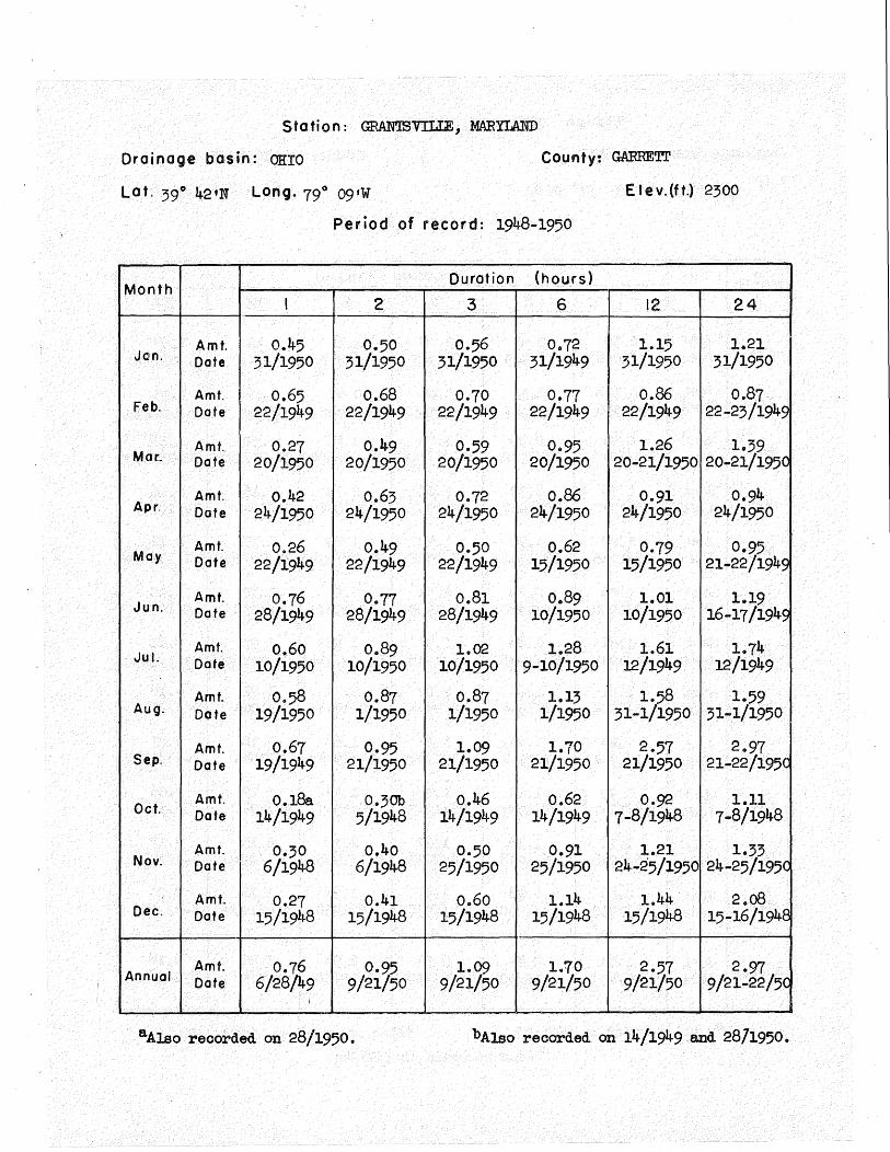
S tot ion : GRAN'IBVILIE, MARYLAND
Drainage basin: OHIO County: GARRETl.'
Lat. 39° 42•N Long. 79° 09•W Elev.(ft.) 2300
Period of record: 1948-1950
Month Duration (hours)
I 2 3 6 12 24
Amt. 0.45 0.50 0.56 0.72 1.15 1.21 Jan. Date 31/1950 31/1950 31/1950 31/1949 31/1950 31/1950
Amt. 0.65 0.68 0.70 0.77 0.86 0.87 Feb. Date 22/1949 22/1949 22/1949 22/1949 22/1949 22-23/1949
Moe. Amt. 0.27 0.49 0.59 0.95 1.26 1.39 Date 20/1950 20/1950 20/1950 20/1950 20-21/1950 20-21/1950
Amt. 0.42 0.63 0.72 0.86 0.91 0.94 Apr. Date 24/1950 24/1950 24/1950 24/1950 24/1950 24/1950
May Amt. 0.26 0.49 0.50 0.62 0.79 0.95 Date 22/1949 22/1949 22/1949 15/1950 15/1950 21-22/1949
Jun. Amt. 0.76 0.77 0.81 0.89 1.01 1.19 Date 28/1949 28/1949 28/1949 10/1950 10/1950 16-17/1949
Amt. 0.60 0.89 1.02 1.28 1.61 1.74 Ju I. Date 10/1950 10/1950 10/1950 9-10/1950 12/1949 12/1949
Amt. 0.58 0.87 0.87 1.13 1.58 1.59 Aug. Date 19/1950 1/1950 1/1950 1/1950 31-1/1950 31-1/1950
Amt. 0.67 0.95 1.09 1.70 2.57 2.97 Sep. Date 19/1949 21/1950 21/1950 21/1950 21/1950 21-22/195C
Oct. Amt. 0.1&. 0.30b 0.46 0.62 0.92 1.11 Date 14/1949 5/1948 14/1949 14/1949 7-8/1948 7-8/1948
Amt. 0.30 0.40 0.50 0.91 1.21 1.33 Nov. Date 6/1948 6/1948 25/1950 25/1950 24-25/1950 24-25/195C
Amt. 0.27 0.41 0.60 1.14 1.44 2.o8 Dec. Date 15/1948 15/1948 15/1948 15/1948 15/1948 15-16/1948
Annual Amt. 0.76 0.7§ 1.09 1.70 2.57 2.97 Date 6/28/49 9/21 50 9/21/50 9/21/50 9/21/50 9/21-22/50
I
aAlso recorded on 28/1950. bAlso recorded on 14/1949.and 2871950.

Sf at ion : REEDYS'VILU:, MARYLAND
Drainage basin: POTOMAC
Lat. 39° 29'N Long. 77° 42 'W
County: WASHINGTON
Elev.(ft.) 420
Period of record: 1950
Month Duration (hours)
I 2 3 6 12 24
Amt. 0.11 0.20 0.26 0.46 0.66 0.83 Jan. Date 31/1950 31/1950 31/1950 31-1/1950 31~1/1950 31-1/1950 Amt. 0.24 0.41 0.56 0.79 0.87 0.87 Feb. Date 9/1950 9/1950 9/1950 9/1950 9/1950 9/1950
Mar. Amt. 0.27 0.49 0~68 1.o6 1.35 1.51 Date 22/1950 22/1950 22/1950 22/1950 22-23/1950 22-23/1950 Amt. 0.18 0.23 0.27 0.37 o.4o 0.46 Apr, Date 23/1950 23/1950 23/1950 23/1950 23/1950 22-23/1950 Amt. 0.52 0.61 0.83 1.21 1.47 1.51 May Date 23/1950 23/1950 15/1950 15/1950 15/1950 15/1950
Jun. Amt. 0.21 0.21 0.24 0.43 0.58 0.68 Date 20/1950 20/1950 4/1950 4/1950 3-4/1950 3-4/1950 Amt. 0.37 0.41 0.41 0.41 0 .. 44 0.47 Jul. Date 3/1950 3/1950 3/1950 3/1950 9-10/1950 9-10/1950 Amt. 1.94 2.(jf 2.09 2.21 2.28 2.34 Aug. Dote 19/1950 19/1950 19/1950 19/1950 19-20/1950 19-20/1950 Amt. 0.86 1.07 1.11 1.26 1.69 1.90 Sep. Date 1/1950 1/1950 1/1950 1/1950 21/1950 21-22/1950
Oct. Amt. 0.32 0 .. 56 0.71 0.83 1.09 1.44 Date 23/1950 8/1950 8/1950 8/1950 8-9/1950 8-9/1950 Amt. 0.70 1.25 1.60 2.42 3 .-;4 3.~4 Nov. Date 25/1950 25/1950 25/1950 25/1950 ~5-26/1950 ~5-26/1950
Amt. 0.39 0.73 1.00 1.89 2.51 2.63 Dec. Date 4/1950 4/1950 4/1950 4/1950 3-4/1950 3-4/1950
Amt. 1.94 2 .. 07 2.09 2.42 3.34 3.34 Annual Date 8/19/50 8/19/50 8/19/50 11/25/50 P-1/25-26/50 ~l/25-26/5C --

S t a f ion : lEONARDTOWN, MARYL.AED
Drainage basin: POTOMAC County: ST MARYS
Lat. 38° l5'N Long. 76° 39'W E I e v. (ft.) 20
Period of record: 1944-1950
Month Duration {hours)
I 2 3 6 12 24
Amt. . 0.79 1.13 1.34 1.90 2.;4 2.79 Jan. Date 21/1949 21/1949 21/1949 21/1949 21/1949 !12-13/1948
Am f. 0.24 0.35 0.45 0.59 0.99 1.14 Feb. Date 28/1949 28/1949 28/1949 19/1946 20/1947 20-21/1947
Mar:. Amt. 0.62 0.,89 0.95 1.01 1.14 1.15 Date 23/1949 23/1949. 23/1949 22/1950 6-7/1948 22-23/1950
Amt. 1.14 1 .. 87 1.88 1.90 1.92 1.92 Apr. Date 12/1947 12/1947 12/1947 12/1947 11-12/1947 ll-12/1947
May Amt. 1.02 1.05 1.23 1.78 2.29 2.29 Date 17/1945 22/1947 22/1947 25/1947 25/1947 25/1947
Jun. Amt. 1.8; 2 .. 26 2.27 2.64 2.65 2.69 Date 10/1945 10/1945 10-11/1945 10-11/1945 10-11/1945 10/1945
Amt. 1.30 1.50 1.65 2.51 3-18 5.38 Jul. Date 9/1945 9/19lt5 9/1945 17/1945 17/1945 17-18/1945
Amt. 2.02 2.23 2.44 3.20 :;.45 5.67 Aug. Dote 20/1950 20/1950 20/1950 3/1948 3/1948 3-4/1948
Amt. 1.31 1 .. 41 1.47 1.61 l.}i 2.24 Sep. Date 13/1944 13/1944 13/1944 13/1944 20-21.1946 20-21/1946
Oct Amt. 1.27 1 .. 56 1.73 . 2.32 3.15 3.26 Date 31/1949 31/1949 31/1949 31/1949 ;30-31/1949 30-31/1949
Amt. 0.51 o.8o 1.,00 1.33 1.64 2.00 Nov. Date 4/1950 25/1950 25/1950 l/19J9 27/1944 27/1944
Amt.. 0.28 0 .. 49 0.58 0.78 1.14 1.43 Dec. Dote 25/1945 25/1945 25/1945 30/1948 30/1948 3-4/1948
Annual Amt. 2.02 2 .. 26 2.44 3 .. 20 :;.45 5.67 Date 8/20/50 6/10/45 8/20/50 8/3/48 8/3/'48 8/3-4/48

Station: LUKE, MARYLA:ND
Drainage basin: POTOMAC
Lat. 39° 29'N Long. 79° o;•w
County: .ALIEGA:NY
E I e v. (ft.) 950
Period of record: 1943-1950
Month Duration {hours)
I 2 3 6 12 24
Amt. 0.31 0.58 o.Bo 1 .. 40 1.75 1.85 Jon. Date 1/1948 1/1948 1/1948 1/1948 1/1948 1-2/1948 Amt. 0.30 0.59 0 .. 79 0.90 1.23 1.:;:; Feb. Dote 9/1950 9/1950 9/1950 8-9/1950 25-26/1944 25-26/1944
Mar:. Amt. 0.51 o.~ 0.69 0.76 0.97 1.2:; Dote 21/1945 23/1948 6/1944 23-24/1948 20-21/1950 4-5/194lt Amt. o .. 4o 0.65 0.87 1.21 1.:;6 1 .. 71 Apr. Dote 8/1948 12/1948 12/1948 12/1948 12/1948 12/1948 Amt. 1 .. 02 1.22 1.41 1.52 1.97 2.22 May Dote 3/1947 3/1947 9/1949 9/1949 6/1944 6-7/1944
Jun. Amt. 0.90 0.95 1.40 1.82 2.50 :;.o8 Dote 23/1944 15/1945 23/1944 17/1949 17/1949 17-18/1949 Amt. 1.29 2.10 2.32 2.99 3-39 3.40 Jul. Dote 3/19'+8 3/1948 3/1948 l2/1949 12/1949 12/1949 Amt. 1.26 1.46 1.47 1.74 2.o8 2.67 Aug. Date 22/1947 22/1947 22/19lf7 17-18/1949 23-24/1945 23-24/1945
Amt. 1.20 1.50 1.74 1.91 2.18 , .. 2.48 Sep. Date 8/1945 8/1945 8/1945 8/1945 8-9/1945 21-22/1950
Oct. Amt. 0.61 1.19 1.39 1.64 2 .. 29 2.60 Date 9/1950 9/1950 9/1950 20/1944 20/1944 20-21/1944 Amt. o.;o 0.52 o.8o 1.20 1 .. 32 1.44 Nov. Dote 3/1947 3/1947 3/1947 3/1947 3/1947 3-4/1947 Am f. 0.26 0.52 0 .. 74 o.8:; 1.29 1.99 Dec. Date 7/1950 7/1950 7/1950 7/1950 15-16/1948 15-16/1948
Amt. 1.29 2.10 2.32 2.99 3.39 3.40 Annual Dote 7/3/lt-8 7/3/48 7/3/48 7/12/49 7/12/49 7/12/49

S ta ti on : NEW GERMANY, MARYLAND
County: GARRET!' Drainage basin: SUSQUEHANNA
Lat. 39° 38•N Long. 79° 07 'W E lev.(ft.) 2490
Period of record: 1949-1950
Month Duration (hours)
I 2 3 6 12 24
Amt. N 0 R E c 0 R D Jan. Date
Amt. 0.19 0.32 0.40 0.50 0.65 0.68 Feb. Date 9/1950 9/1950 9/1950 9/1950 8-9/1950 8-9/1950
Mar. Amt. 0.17 0.26 o.4o 0.57 0.91 0.95 Date 20/1950 20/1950 20/1950 20/1950 20-21/1950 20-21/1950
Amt. o.2oa 0.32 0.38 0 .. 55 0.62 0.72 Apr. Date 23/1950 24/1950 23/1950 24/1950 24/1950 23-24/1950
Amt. 0 .. 36 0.39 0.45 0.63 0.86 0 .. 86 May Date 27/1950 27/1950 25/1950 15/1950 15/1950 15/1950
Jun. Amt. 0.42 0.69 0.77 0.77 0 .. 77 0.77 Date 24/1950 24/1950 24/1950 24/1950 24/1950 24/1950
Amt. 0.51 0.77 1.00 1 .. 12 1.12 1.14 Ju I. Date 10/1950 9-10/1950 9-10/1950 9-10/1950 9-10/1950 9-10/1950
Amt. 0.44 0 .. 60 0.64 0.67 0.72 l.o8 Aug. Dote 19/1950 19/1950 19/1950 19/1950 19/1950 19/1950
Amt. 0.84 1.30 1.63 2.69 3.33 3.8:; Sep. Date 21/1950 21/1950 21/1950 21/1950 21/1950 21/1950
Oct. Amt. 0.25 0 .. 36 0.48 0 .. 74 0.94 0.94 Date 15/1949 15/1949 15/1949 15/1949 15-16/1949 15-16/1949
Amt. 0.28 0 .. 50 o.67 0.91 1.14 1.34 Nov. Dote 28/1949 28-29/1949 28-29/1949 24-25/1950 24-25/1950 24-25/1950
Amt. 0.23 0.46 0.65 0.75 o.80b o.8oc Dec. Date 7/1950 7/1950 7/1950 7/1950 26/1949 26/1949
Amt. 0.84 1.30 1.63 2.69 3·33 3.83 Annual Date 9/21/50 9/21/50 9/21/50 9/21/50 9/21/50 9/21/50
---
a. Also :recorded on 24/1950.. b Also recorded on 7/1950. 0Also recorded on 7/1950.

5 tat ion : POINT LOOKOUT, MARYLA:ND
0 rain age basin : POTOMAC Am> CE:ES.APE.AEE County: ST MARYS
Lat. 38° 02 1N Long. 76° 19•W E lev.(ft.} 10
Period of record: 1941-1947
Month Ourat ion (hours}
I 2 3 6 12 24 '
Amt. 0.77 0.77 0.82 1.28 1.91 2.o8 Jan. Date 20/1947 20/1947 3/1944 3/1944 3/1944 2-3/1944
Amt. 0.46 0.56 0.68 0.88 1.02 1.05 Feb. Dote 14/1946 14/1946 6-7/1942 6-7/1942 28-29/1944 28-29/1944
Mar:. Amt. 0.60 0.87 1 .. 09 1.40 2.05 2.45 Dote 2/1942 2/1942 2/1942 19/1946 19/1946 19/1946
Amt. 0 .. 79 1.54 1 .. 82 2.42 2.75 2.86 Apr, Dote 19/1943 19/1943 19/1943 19/1943 19/1943 19/1943
Amt. 0.75 0.81 0.81 1.25 1.47 1.55 May Date 10/1943 10/1943 10/1943 26/1945 26/1945 26-27/1945
Jun. Amt. 2.62 2.72 2.79 2.80 2.80 2.80 Dote 1/1944 1/1944 1/1944 1/1944 1/1944 1/1944
Am f. o.€4 1.10 1.13 1.28 . 2.15 2.49 Jul. Dote 20/1944 15/1945 2/1945 2/1945 15/1945 15-16/1945
Amt. 1.49 1 .. 83 1.97 2.04 2.20 2.28 Aug. Dote 8/1942 8/1942 8/1942 8/1942 8-9/1942 8-9/1942
Amt. 1.59 1.67 1.69 2.41 3.31 3.46 Sep. Dote 24/1946 24/1946 24/1946 24/1946 24/1946 24/1946
Oct. Amt. 1.75 1.95 2.03 2.14 3.49 3.71 Dote 26/1943 26/1943 26/1943 26/1943 26/1943 25-26/1943
Amt. 0.47 0.48 0.51 0.8; 1.25 1.52 Nov. Dote 8/1946 8/1946 30/1944 27/1944 27/1944 27/1944
Amt. o.;2 0.53 0.57 0.85 1.32 1.75 Dec. Date 13/1941 13/1941 13/1941 13/1941 28-29/1945 28-29/1945
Amt. 2.62 2.72 2.79 2.80 ;.49 3.71 Annual Dote 6/1/44 6/1/44 6/1/44 6/1/44 10/26/43 !uf25-26/43

Station : ROEERSVII.JE 1 MARYLAND
Drainage basin: POTOMAC County: WASHINGTON
Lot, 39° 26'N Long. 77° 4o•w E I e v. (ft.) 500 (Estimated)
Period of record: 1940-1947
Duration (hours) •....
Month I 2 3 6 12 24
"'
Amt. 0.45 0 .. 56 0.76 0.93 1.26 1.86 . Jan. Date 30/1947 30/1947 30/1947 3/1944 28/1943 3-4/1944
Amt. 0.23 0.45 0.62 1 .. 01 1.46 1 ... 62 Feb. Date 6/1942 6/1942 20/1947 20/1947 20/1947 ~0-21/1947
Amt. 0 .. 48 0.60 o.Bo 1.01 1 .. 32 2.07 Mar. Dote 17/1943 17/1943 17/1943 17 /1943· 29/1942 28-29/1942
Amt. 0 .. 54 0.55 0.70 1.22 1.68 1.81 Apr, Dote 30/1947 30/1947 5/1941 5/1941 5/1941 4-5/1941
Amt. 0.73 0.92 1.12 1.50 1.71 2.16 May Dote 29/1947 16/1942 16/1942 16/1942 26-27/1946 21-22/1942
Jun. Amt. 0.67 1.31 1.82 2.52 3.00 :;.19 Date 2/1946 2/1946 2/1946 1-2/1946 1-2/1946 1-2/1946
Amt. 1.4:; 1.43 1.45 1.6:; 1.84 1.94 Jul. Dote 20/1942 20/1942 10/1942 10/1942 15/1945 14-15/1945
Amt. 0.84 1.:;o 1.:;6 1.;6a 1.46 2.02 Aug. Dote 31/1944 30/1945 6/1946 30-31/1945 ' 8/1942 8/1942
Amt. 1.19 1.47 1.69 2.00 3.76 4.04 Sep. Dote 13/1944 12-13/1944 12-13/1944 25/1940 ~4-25/1940 ~4-25/1940
Oct. Amt. 0.45 0.64 0.81 1.14 1.58 2.42 Date 7/1944 12/1946 12/1946 14/1942 13-14/1942 14-1;-/1942
Amt. 0.88 1.16 1 .. 84 2.19 2.52 2.88 Nov. Dote 8/1943 8/1943 8/1943 8/1943 8/1943 8/~943
Amt. 0 .. 6:; 0.81 0.86 1.16 1.40 1.65 Dec. Dote 24/1941 4/1941 4/1941 4-5/1941 13/1941 12-13/1941
Amt. la43 la47 1.84 2 .. 52 ~·76 4.04 Annual Dote 7/20/42 ~/l2-13/44 11/8/43 6/1 .. 2/46 ~/2 -25/40 ~/24-25/40
aA1so recorded on 6/1946. I

Station: SAVAGE RIVER DAM, MARYLAND
Drainage basin: POTOMAC County: GARRETT
Lot. 39° 30'N Long. 79° o8•W E lev.(ft.) 1460
Period of record: 1949-1950
Month Ourot ion (hours)
I 2 3 6 12 24
Amt. 0.17 0.30 0.37 0.47 0.69 0.72 Jan. Date 29/1950 29/1950 29/1950 29/1950 29-30/1950 29-30/195C
Amt. 0.28 0.50 0.71 0.83 0.92 0.95 Feb. Date 9/1950 9/1950 9/1950 9/1950 9/1950 9/1950
Mar. Amt. 0.12 0.19 0.27 0 .. 39 0.58 0.64 Date 8/1950 21/1950 21/1950 13/1950 20-21/1950 12-13/195(
Amt. 0.31 0.50 0.50 0.50 0.51 0.98 Apr, Date 30/1950 30/1950 30/1950 30/1950 30/1950 30/1950
May Amt. 0.29 0.42 0.52 0.78 1.06 1.o6 Date 2/1950 2/1950 2-3/1950 15/1950 15/1950 15/1950
Jun. Amt. 0.38 0.39 0.44 0.62 0.72 0.72 Date 10/1950 10/1950 10/1950 18-19/195C 18-19/1950 18-19/195(
Amt. 0.66 0.89 1.00 1.20 1 .. 23 1.24 Jul. Date 10/1950 10/1950 10/1950 9-10/1950 9-10/1950 9-10/1950
Amt. 0.17 0.20 0.21 0.33 0.35 0.35 Aug. Dote 30/1950 30/1950 30/1950 30/1950 30/1950 30/1950
Amt. 0.49 0.81 1 .. 21 1.93 2.85 ;.;6 Sep. Date 21/1950 21/1950 21/1950 21/1950 21/1950 21~22/195(
\,
0.26 0.42 0 .. 58 Amt. 0.35 0.97 0.99 Oct. Date 15/1949 9/1950 14/1949 14/1949 14-15/1949 14-15/1945
Amt. 0.22 0 .. 38 0.50 0.73 1.12 1.12 Nov. Date 29/1949 28-29/1949 28-29/1949 28-29/1949 28-29/1949 28-29/1945
Amt. 0.26 0.50 0.66 0.78 0.99 1.00 Dec. Date 7/1950 7/1950 7/1950 7/1950 7/1950 7/1950
Amt. 0.66 0.89 1.21 1.~ 2.85 3.36 Annual Date 7/10/50 7/10/50 9/21/50 9/21 50 9/21/50 9/21-22/50

5 tat ion : SHARPTOWN, MARYLAliD
Drainage basin: CHESAPEAKE
Lat. 38° 33'N Long. 75° 4,3 9W
County: WICOMICO
E lev.(ft.) 10
Period of record: 1941-1950
Durot ion {hours) Month
I 2 3 6 12 24
Amt. 0.40 0.68 0.78 1.01 1.74 2.66 Jon. Date 1/1948 1/1948 1/1948 3/1944 13/1948 12-13/1948
Amt. 0.28 0.44 0 .. 59 0 .. 90 1.10 1.10 Feb. Date 19/1946 14/1946 6-7/1942 6-7/1942 13/1945 13/1945
Mar:. Amt. 0.61 0.87 1.14 1.37 1.70 1.75 Dote 28/1950 2-3/1942 2-3/1942 2-3/1942 31-1/1948 31-1/1948
Amt. 0.61 0.96 1.29 1.46 1.71 1.75 Apr. Date 16/1947 16/1947 16/1947 16/1947 1/1948 31-1/1948
Amt. 2.16 2.46 2.67 ;.o1 ;.17 :;.44 May Date 15/1950 15/1950 15/1950 15/1950 15/1950 15-16/1950
Jun. Amt. 1.20 1.46 1.79 2.;8 2.45 2•45 Date 2/1945 2/1945 2/1945 2-3/1945 2-3/1945 2-3/1945
Amt. 1.39 2.o8 2.70 4.22 4.50 4.53 Jul. Date 20/1945 2/1946 2/1946 2/1946 2/1946 2/1946
Amt. 2.o8 2.31 2.38 2.4:; 2.70 3.05 Aug. Dote 18/1946 18/1946 23/1945 23/1945 19-20/1941 3-4/1948
Amt. 0.98 1.83 2.50 3·15 3.20 3.25 Sep. Date 14/1944 14/1944 14/1944 14/1944 14/1944 14-15/1944
Oct. Amt. 0.69 1 .. 29 1.65 2.16 2.54 3.49 Date 23/1945 23/1945 ' 23/1945 23/1945 5/1948 5·-6/1948
Amt. 0.86 1.34 1.57 1.89 2.~ 2.46 Nov. Date 1/1949 1/1949 1/19~9 1/1949 24-25 1950 27-28/1944
Amt. 0.48 0.68 0.95 1.61 2.16 2.34 Dec. Date 13/1941 13/1941 5/1945 5/1945 5/1945 5-6/1945
Annual Amt. 2.16 2.46 2.70 4.22 4.50 4.53 Date 5/15/50 5/15/50 7/2/46 7/2/46 7/2/46 7/2/46
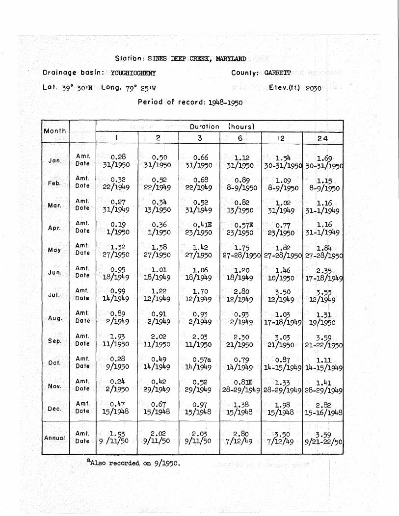
Stat ibn :· S INE3 DEEP CREEK, MARYLA.ND
Drainage basin: YOtrmiOGHENY
Lat. 39° 30•N Long. 79° 25•W
County: GARRE~
E lev.(ft.) 2030
Period of record: 1948~1950
Month Ourot ion (hours)
I 2 3 6 12 24
Amt. 0.28 0 .. 50 0.66 1.12 1.54 1.69 Jan. Date 31/1950 31/1950 31/1950 31/1950 30-31/1950 30-31/195( Amt. 0.32 0.52 0.68 0.89 1.09 1.15 Feb. Date 22/1949 22/19'49 22/1949 8-9/1950 8-9/1950 8-9/1950
Mar. Amt. 0.27 0.34 0.52 0.82 1.02 1.16 Date 31/1949 13/1950 31/1949 13/1950 31/1949 31-1/1949 Amt. 0.19 0.36 o.4lE 0.57E 0.77 1.16 Apr. Date 1/1950 1/1950 23/1950 23/1950 23/1950 .31-1/1949
May Amt. 1.32 1.38 1.42 1.75 1.82 1.84 Date 27/1950 27/1950 27/1950 27-28/1950 27-28/1950 27-28/195C
Jun. Amt. 0.95 1.01 1.o6 1.20 1.46 2.35 Date 18/1949 18/1949 18/1949 18/1949 10/1950 17-18/1949 Am f. 0.99 1.22 1.70 2.80 3.50 3·55 Jul. Date 14/1949 12/1949 12/1949 12/1949 12/1949 12/1949
Amt. 0.89 0.91 0.93 0.93 1.03 1.31 Aug. Date 2/1949 2/1949 2/1949 2/1949 17-18/1949 19/1950
Amt. 1.93 2.02 2.03 2.30 3.o; 3·59 Sep. Date 11/1950 11/1950 11/1950 21/1950 21/1950 21-22/1950
Oct. Amt. 0.28 0.49 0.57a 0.79 0.87 1.11 Date 9/1950 14/1949 14/1949 14/1949 14-15/1949 14~15/1949
Am f. 0.24 0.42 0.52 o.8lE 1.33 1.41 Nov. Date 2/1950 29/1949 29/1949 28-29/1949 28-29/1949 28-29/1949
Am f. 0.47 0.67 0.97 1.38 1.98 2.82 Dec. Date 15/1948 15/1948 15/1948 15/1948 15/1948 15-16/1948
Amt. 1. 23 2.02 2./§ 2.80 A·50 3·59 Annual Date 9 /11/50 9/11/50 9/11 50 7/12/49 7 12/49 9/21-22/50
aAlso recorded on 9/1950.

S ta ti on : ~Iomvn.J:E, MARYWJD
Drainage basin: POTOMAC County: FREli.ERICK
Lat. 39° 27 1N Long. 77° ll'W E 1 e v. (ft.) 4;o
Period of record: 1940 ... 1950
Month Ourot ion (hours}
I 2 3 6 12 24
Jan. Amt. 0 .. 48 0.81 1.12 1 .. 88 2.47 :;.18 Date 1/1948 1/1948 1/1948 1/1948 1/1948 :;-4/1944
Amt. 0.27a 0.49 0.67 0.96 1.02 1.l'"fb Feb. Date 6/1942 26/1945 26/1945 26/1946 20/1947 18-19/194o
Mar:. Amt. 0.36 0.68 0.96 1.47 1.97 2.13 Date 22/1950 22/1950 2/1950 22/1950 22-23/1950 22-23/1950
Amt. 0 .. 42 0.55 0.72 1.12 1.68 2.13 A pro Date 30/1947 18/1949 18/1949 5/1941 8/1940 8/1940
May Amt. 2.89 ;.12 ;.65 ;.82 4.19 4.99 Date 21/1942 21/1942 21/1942 21/1942 21/1942 21-22/1942
Jun. Amt. 1.97 2.21 2.23 2.73 :;.81 5·59 Date 23/1944 12/1942 12/1942 l-2/19116 1-2/1946 1-2/1946
Jul. Amt. 1.47 2.o6 2.78 2.86 2.86 2.87 Date 2/1941 31/1945 2/1941 2/1941 2/1941 2-3/1941
·Amt. 1.54 2 .. 38 2.40 4.07 4.14 4.14 Aug. Date 13/1942 13/1942 13/1942 13/1942 13-14/1942 13-14/1942
Amt. 1.25 1.37 1.45 2.:;8 4.02 ·4.21 Sep. Date 25/1940 25/1940 25/1940 25/1940 24-25/1940 24-25/1940
Oct. Amt. 0.70 0.93 1.o6 1.69 1.8:; 2.76 Date 16/1943 16/1943- 16/1943 15/19'42 15-16/1942 15-16/1942
Amt. 1.20 1.52 1.93- 2.52 2.91 3.01 Nov. Date 25/1950 25/1950 25/1950 25/1950 24-25/1950 24-25/1950
Amt. 0 .. 55 0.8:; 1.17 1.6; 1.8:; 1.90 Dec. Dote 8/1944 4/1950 4/1950 3-4/1950 ;-4/1950 28-29/1948
Annual Amt. 2.89 3.12 :;.65 4.07 4.19 5·59 Date 5/21/42 5/21/42 5/21/42 8/13/42 5/21/42 6/1-2/46
aAlso recorded on 26/1945 .. bA1so recorded on 20-21/1947.

Station: WASHINGTON WB CITY, DJB'miCT OF COLUMBIA*
Oraina9e basin: POTOMAC County: DJBTRICT OF COLUMBIA
Lat. 38° 54 •N Long. 77° 03 •W E lev.(ft.) 72
Period of record: 1940-1950 ONLY
Month Duration (hours}
I 2 3 6 12 24
Amt. 0.39 0.57 0.68 1 .. o4 1.45 1.72 Jan. Date 18/1943 1/1948 1/1948 1/1948 28/1943 3-4/1944
Amt. 0 .. 30 0.50 0 .. 69 1.o4 1.22 1.25 Feb. Date 6/1942 6/1942 6/1942 6-7/1942 6-7/1942 6-7/1942
Mar:. Amt. 0.66 0.98 1.26 1.29 1.56 1.88 Date 23/1948 23/1948 23/1948 23-24/1948 28-29/1942 23-24/194E
Amt. 0.77 1.09 1.12 1.49 2.02 2.30 Apr. Date 30/1947 30/1947 30/1947 20/1940 19-20/1940 19-20/194< Amt. o .. 86a 1 .. 25 '1 .. 28 1.58 1.94 2.18 May Date 18/1946 15/1950 15/1950 13/1948 12-13/1948 12-13/194c
Jun. Amt. 1.67 2.16 2.23 2.2; 3.35 3.40 Date 10/1945 10/1945 10/1945 10/1945 26-27/1942 26-27/1942
Amt. 1.32b 2.29 2.55 2.60 2.60 2.76 Jul. Date 13/1941 23/1940 23/1940 23/1940 23/1940 31-1/1948 ·Amt. 2.11 3.23 3.91 4.71 5.89 6.15 Aug. Date 2/1944 2/1944 2/1944 2/1944 2/1944 2-3/1944
Amt. 1.16 1.84 2.o4 2.73 2.97 :;.12 Sep. Date 23/1946 10/1950 10/1950 10/1950 10/1950 9-10/1950
Oct. Amt. 1.54 2.19 2.31 2.51 2.59 3.01 Date 15/1942 15/1942 15/1942 15/1942 15-16/1942 15-16/1942
Amt. 1.42 2.02 2.54 2.70 3.03 3.20 Nov. Date 8/1943 8/1943 8/1943 8/1943 8-9/1943 8-9/1943
Amt. o.,Sc 0.79 1.12 1.46 1.93 2 .. 21 Dec. Date 5/1941 4/1950 4/1950 4/1950 13/1941 12-13/1941
Annual Amt. 2.11 3·[4 3.91 4.71 ;.89. 6.15. Date . 8/2/44 8/2 44 8/2/44 8/2/44 8/2/44 8/2-3/44
*Given for comparative purposes. See next page for complete record.
S.Also recorded on 22/1947 and 2/1949. bAlso recorded on 10/1942. cAlso recorded on 4/1950. August 2 and 3 hour and all of November are true maxima ..

Station: WASHINGTON· WB CITY, DlBTRICT OF COLUMBIA
Drainage basin: POTOMAC
Lat. 38 o 54 •N Long. 77 o 03 •W
County: DJBTICT OF COLUMBIA
E lev.(ft.) 72
Period of record: 1889-1950
Month Duration (hours)
I 2 3 6 12 24
Amt. 0.57 0.88 1.23 1.41 1.72 2.98 Jan. Date 24/1899 . 21/19Cf2. 21/19Cf2. 3/19t4 2-3/1936 12-13/1915
Amt. 0.62 0.79 0.96 1.26 1.60 2.29 Feb. Date 21/1937 28/1939 28/1939 16/1899 4/1932 6/1896 .
Mar:. Amt. 1.Cf2. 1.19 1.;4 1.76 2.o6 2.80 Date 24/1905 24/1905 27-28/1932 27-28/1932 27-28/1932 3-4/1909
Amt. 0.78 1.15 1.52 1.90 2.37 3.20 Apr. Date 21/1927 21/1927 11/1919 11/1919 11-12/1913 11-12/1913
May Amt. 1.57 1.88 2.17 2.94 3.14 ;.50 Date 3/1936 3/1936 3/1936 19/1900 19/1900 7-8/1889
Jun. Amt. 2.66 ;.22 3.45 3.48 3.56 3.56 Date 8/1900 2/1900 2/1900 2/1900 1-2/1900 1-2/1900
Amt. 2.79 ;.33 3.47 3.69 3.72 4.22 Jul. Date 13/1922 5/1905 5/1905 5/1905 5-6/1905 5-6/1905
Amt. 2.48 .. 3.23 ;.91 5.38 6.20 7.31 Aug. Dote 24/1906 2/1944 2/194lt- 11-12/1928 11-12/1928 11-12/1928
Amt. 3.42 3-91 4.14 5-15 5.16 5.16 Sep. Dote 12/1934 4/1939 2/1922 2/1922 2/1922 2/1922
Oct. Amt. 2.29 2.63 2.86 3.10 3.62 3.67 Date 20/1910 20/1910 19-20/1910 19-20/1910 19-20/1910 19-20/1910
Amt. l.lt-2 2.02 2.54 2.70 3.03 3.20 Nov. Date 8/1943 ' 8/194; 8/1943 8/1943 8-9/1943 8-9/1943
Amt. 0.59 1.06 1.35 1.68 2.22 2.43 Dec. Date 14/1918 13/1909 13/1909 13/1909 13/1909 13/1909
Amt. ;i.42 "'.91 4.14 5.38 6.20 7-31 Annual Date 9 12/34 9 4/39 9/2/22 8/11-12/28 8/11-12/28 8/11-12/28
·All values are true maxima

5 fa f ion : WASHmGTON (NATL AIRPORT) 1 D. C •
Drainage basin: POTOMAC County: DJBTRICT QF COLUMBIA
Lat . .38° 51'N Long •. 77° 02•W E I e v. (ft.) JA,
Period of record: 194.3-1950
Month Duration (hours)
I . 2 3 6 12 24
Amt. 0.42 0.61 0.77 1.o6 1.40 1.7.3 Jan. Date 1/1948 1/1948 1/1948 1/1948 28/1943 12-1.3/1948
Amt. 0.27 0.41 0.62 o.Bo 0.93 0.93 Feb. Date 19/1946 19/1946 19/1946 19/1946 19/1946 19/1946
Mar. Amt. . 0.;6 0.6; 0.92 1.25 1.75 1.77 Date 2'2 /1<J5.0 22./1~ 31-1/1948 31-1/1948 31-1/1948 .31-1/1948
' Amt. 0.58 0.88 1.10 1.25 1.75 1.77 Apr. Date 27/1950 1/1948 1/1948 31-1/1948 31-1/1948 31-1/1948
Amt. 1.o8 1.;4 1.60 1.76 2.25 2.62 May Date 28/1943 30/1948 22/1949 22/1949 13/1948 12-13/1948
Jun. Amt. 1.47 2.91 3.20 3.44 3.44 §·67 Date 7/1947 7/1947 7/1947 7/1947 7/1947 . 1- /1947
Amt. 1.84 1.85 1.85 1.85 2.o4 3.67 Jul. Date 27/1944 27/1944 27/1944 27/1944 17-18/1945 31-1/1948
Am f. 1.51 2.62 3.39 4.26 5.18 5.31 Aug. Date 19/1950 23/1950 2/1944 2/1944 2/1944 2-3/1944
Amt. 0.91 1.67 1.76 2.21 2.70 2.97 Sep. Date 15/1947 10/1950 10/1950 10/1950 10/1950 9-10/1950
Oct. Amt. 0.74 0.94 1.01 1.40 1.81 2.33 Dote 28/1947 28/1947 28/1947 28/1949 22-23/1950 25-26/1943
Amt. 0.82 1.42 1.97 2.36 3.03 3.13 Nov. Dote 8/1943 8/1943 8/1943 8/1943 .. 8-9/194.3 8-9/1943
Amt. 0.46 0.76 0.91 1.32 1.45 1.63 Dec. Date 4/1950 4/1950 4/1950 4/1950 3-4/1950 3-4/1950
Amt. 1.811. 2.91 3·39 4.26 5.18 5.31 Annual Date 7/27/44 6/7/47 8/2/44 8/2/44 . 8/2/44 8/2-3/44 ..
U.S. GOVERNMENT PRINTING OFFICE: 0-1954


