maryland historical trust continuation … · reviewer, office of preservation services date...
TRANSCRIPT

MARYLAND HISTORICAL TRUST CONTINUATION SHEET Property Name: Furgang Farm U.S. 301 SOUTH CORRIDOR TRANSPORTATION STUDY Survey No:PG:82A-23(PACS B127)
Property Address 10811 Old Indian Head Road, Cheltenham, Prince George's County Owner Name/Address Richard Snyder, Land and Communications Limited Partnership, 1377 K Street, NW, Washington, D.C. 20005 Year Built 1897
Description:
The Furgang Farm was previously surveyed by the Maryland-National Capital Parks and Planning Commission (M-NCPPC) in 1974 and by the Prince George's County Historic Preservation Commission in 1986. Since the time of the previous survey, the complex of outbuildings east of the house, comprised of a chicken coop, shed and the structure known as the "old house", are no longer extant. In addition, a new residence has been constructed on the adjacent tax parcel with frontage on Old Indian Head Road, east of the house and outbuildings. The condition of the main house has deteriorated considerably since the previous surveys. Also, at the time of the previous survey, the farm comprised 10.9 hectare (27 acres); as a result of the transfer of the property in 1993, the acreage has been reduced to .4 hectare (1 acre).
National Register Evaluation:
The Furgang Farm, constructed in 1897, is a good example of a late nineteenth century farm complex. The property includes a Folk Victorian residence and multiple outbuildings, including a summer kitchen, a milk house, a barn and a carriage house. These structures together represent an intact example of rural architecture in Prince George's County. Despite the loss of several outbuildings, the complex retains good integrity of materials and its setting is largely unaltered. Although the house is now situated on only a .4 hectare (1 acre) parcel, the historic acreage associated with the farm, which surrounds the property, remains largely undeveloped and the orientation between the residence and the railroad is intact. Therefore, the property is eligible for the National Register of Historic Places under Criterion C. The property does not meet Criterion A, as research conducted indicates no association with any historic events or trends significant in the development of national, state or local history. Historic research indicates that the property has no association with persons who have made specific contributions to history, and therefore, it does not meet Criterion B. Finally, it has no known potential to yield important information, and therefore, does not meet Criterion D.
Verbal Boundary Description and Justification:
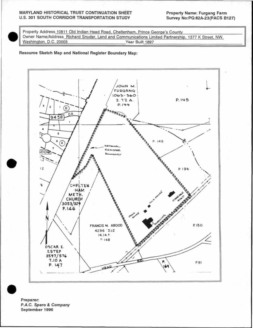
The National Register boundaries of the Furgang Farm follow the current property lines of Parcel 187 on Prince George's County Tax Map 127. This parcel is bounded on the northwest by U.S. 301 and on the southeast by the Conrail (Pope's Creek Line) Railroad. The property was originally known as the "Clubb Farm", which included 60.7 hectare (150 acres). The Furgang family acquired 18.51 hectare (45.75 acres) of the property in 1881, and later constructed the extant dwelling. The property was reduced to 17.4 hectare (43 acres) in 1953 and to 10.9 hectare (27 acres) in 1974. Although the house is currently situated on only .4 hectare (1 acre), the result of a subdivision of the property in 1993, the surrounding 10.5 hectare (26 acres) remains largely undeveloped. Therefore, the proposed boundary for the property includes the entire 10.9 hectare (27 acres) previously associated with the farm. Additional historic acreage has not been included, as development has occurred on these adjacent lands. All structures on the property, including the house, summer kitchen, milk house, carriage shed, barn, and shed contribute to the significance of the property.
MHT CONCURRENCE: Eligibility )\) recommended not recommended Criteria \ A B X C D Considerations A B C D E F G None Comments:
Reviewer, Office of Preservation Services Date \Reviewer, NPrprogram \ Date
Preparer: P.A.C. Spero & Company September 1996

MARYLAND HISTORICAL TRUST CONTINUATION SHEET Property Name: Furgang Farm U.S. 301 SOUTH CORRIDOR TRANSPORTATION STUDY Survey No:PG:82A-23(PACS B127)
Property Address 10811 Old Indian Head Road, Cheltenham, Prince George's County Owner Name/Address Richard Snyder, Land and Communications Limited Partnership, 1377 K Street, NW, Washington, D.C. 20005 Year Built 1897
Description:
The Furgang Farm was previously surveyed by the Maryland-National Capital Parks and Planning Commission (M-NCPPC) in 1974 and by the Prince George's County Historic Preservation Commission in 1986. Since the time of the previous survey, the complex of outbuildings east of the house, comprised of a chicken coop, shed and the structure known as the "old house", are no longer extant. In addition, a new residence has been constructed on the adjacent tax parcel with frontage on Old Indian Head Road, east of the house and outbuildings. The condition of the main house has deteriorated considerably since the previous surveys. Also, at the time of the previous survey, the farm comprised 10.9 hectare (27 acres); as a result of the transfer of the property in 1993, the acreage has been reduced to .4 hectare (1 acre).
National Register Evaluation:
The Furgang Farm, constructed in 1897, is a good example of a late nineteenth century farm complex. The property includes a Folk Victorian residence and multiple outbuildings, including a summer kitchen, a milk house, a barn and a carriage house. These structures together represent an intact example of rural architecture in Prince George's County. Despite the loss of several outbuildings, the complex retains good integrity of materials and its setting is largely unaltered. Although the house is now situated on only a .4 hectare (1 acre) parcel, the historic acreage associated with the farm, which surrounds the property, remains largely undeveloped and the orientation between the residence and the railroad is intact. Therefore, the property is eligible for the National Register of Historic Places under Criterion C. The property does not meet Criterion A, as research conducted indicates no association with any historic events or trends significant in the development of national, state or local history. Historic research indicates that the property has no association with persons who have made specific contributions to history, and therefore, it does not meet Criterion B. Finally, it has no known potential to yield important information, and therefore, does not meet Criterion D.
Verbal Boundary Description and Justification:
The National Register boundaries of the Furgang Farm follow the current property lines of Parcel 187 on Prince George's County Tax Map 127. This parcel is bounded on the northwest by U.S. 301 and on the southeast by the Conrail (Pope's Creek Line) Railroad. The property was originally known as the "Clubb Farm", which included 60.7 hectare (150 acres). The Furgang family acquired 18.51 hectare (45.75 acres) of the property in 1881, and later constructed the extant dwelling. The property was reduced to 17.4 hectare (43 acres) in 1953 and to 10.9 hectare (27 acres) in 1974. Although the house is currently situated on only .4 hectare (1 acre), the result of a subdivision of the property in 1993, the surrounding 10.5 hectare (26 acres) remains largely undeveloped. Therefore, the proposed boundary for the property includes the entire 10.9 hectare (27 acres) previously associated with the farm. Additional historic acreage has not been included, as development has occurred on these adjacent lands. All structures on the property, including the house, summer kitchen, milk house, carriage shed, barn, and shed contribute to the significance of the property.
MHT CONCURRENCE: Eligibility x recommended not recommended Criteria A B x C D Considerations A B C D E F G None Comments:
Suzanne Pickens
Reviewer, Office of Preservation Services
Preparer: P.A.C. Spero & Company September 1996
MARYLAND HISTORICAL TRUST CONTINUATION SHEET Property Name: Furgang Farm U.S. 301 SOUTH CORRIDOR TRANSPORTATION STUDY Survey No:PG:82A-23(PACS B127)
Property Address 10811 Old Indian Head Road, Cheltenham, Prince George's County Owner Name/Address Richard Snyder, Land and Communications Limited Partnership, 1377 K Street, NW, Washington, D.C. 20005 Year Built 1897
Resource Sketch Map and National Register Boundary Map:
Preparer: P.A.C. Spero & Company September 1996


PG:82A-23
PRINCE GEORGE'S COUNTY
HISTORIC SITE SUMMARY SHEET
Survey #: P.G. #82A-23 Building Date: 1897
Building Name: Furgang Farm (Clubb Farm)
Location: 10811 Old Indian Head Road, Cheltenham, Maryland
Private/Residence/Occupied/Excel lent/Inaccessible
Description:
The Furgang farmhouse is a two-and-one-half-story frame T-shaped farmhouse. The principal facade faces roughly south (towards the railroad); entrance is through a door in the first bay of the two-bay (east) stem of the T. The door is surmounted by a transom; sheltering this doorway and filling the corner between the stem and the bar, is a one-story porch, supported by fan-bracketed posts. The south gable end (of the bar of the T) is ornamented with fishscale shingles within the pedimented cornice, and in two panels both above and below the double windows on the first story. The east gable end (of the stem) has the same ornamental shingles within its pedimented cornice, and has a three-window projecting bay at the first story. The siding is German (of Georgia pine) painted white, windows are 2/2, and there are louvered shutters painted dark green. The roof is covered with asphalt shingle, and the foundations are brick. Among the outbuildings (chicken coop, cookhouse, milk house, sheds, etc.) is a small (ca. 16' by 14') gable-roofed building, constructed of hand-cut materials, which predates the other buildings on the farm.
Significance:
The Furgang farmhouse is an excellent example of late Victorian, rural domestic architecture with Queen Anne decorative elements. It was built by Morris Furgang, an engineer for the Baltimore and Potomac Railroad. Furgang's family had emigrated from Germany in the 1850's, and he had worked for the railroad company while the Pope's Creek line was being constructed through Prince George's County. In 1881, his wife purchased 45 acres of the old Clubb farm, and in 1897 they built this handsome dwelling immediately northwest of the railroad tracks. (Family tradition suggests that while the house was being built, the Furgangs lived in the small "old house", a remnant of the earlier Clubb farmstead.) The Victorian dwelling has remained the home of the Furgang family for three generations. Standing by the railroad tracks with its complex of functional farm buildings, it is a prominent and fine example of late Victorian/Queen Anne domestic architecture in a still-rural section of Prince George's County.
Acreage; 23.5 acres

Maryland Historical Trust State Historic Sites Inventory Form
Survey No. P .G. 82A-23
Magi No.
DOE ye s no
1. Name ( ind icate preferred name)
historic Furgang farm
and/or common ( C l u b b Farm)
2. Location street & number 10811 Old Indian Head Road not for publication
city,town Upper Marlboro Cheltenham
vicinity of congressional district
state Maryland county Prince George's
3. Classification Category Ownership Status
district public X occupied L building(s) X private unoccupied
structure both work in progress site Public Acquisition Accessible
_ object in process yes: restricted being considered yes: unrestricted
X not a p p l i c a b l e X. no
Present Use agriculture commercial educational entertainment government industrial military
museum park
X- private residence religious scientific transportation other:
4. Owner of Property (give names and mailing addresses of a l l owners)
name Katharine Furgang Gardner
street & number 1 0 8 1 1 0 1 d Indian Head Road telephone no,
city, town Upper Marlboro, s t a t e and zip code Maryland 20772
5. Location of Legal Description courthouse, registry of deeds, etc.
Prince George's County Courthouse l i b e r
4409
street & number Main Street folio 764
city, town Upper Marlboro
state Maryland
6. Representation in Existing Historical survey: title Prince George's County Inventory of Historic Sites
date 1974
^We
federal state fl county local
pository for survey records H i s t o r y D i v i s i o n , M-NCPPC
city, town Riverdale, state Maryland 20737

7. PeSCriptlOn Survey No. p .G . #82A-23
Condition Check one Check one excellent deteriorated unaltered X_ original site good ruins _X altered moved date o f move fair unexposed
Prepare bo th a summary paragraph and a gene ra l d e s c r i p t i o n of the r e source and i t s v a r i o u s e lements as i t e x i s t s today.
The Furgang farmhouse is a two-and-one-half-story frame T-shaped farmhouse. The pr inc ipa l facade faces roughly south (towards the r a i l r oad ) ; entrance is through a door in the f i r s t bay of the two-bay (east) stem of the T. The door is surmounted by a transom; shel ter ing t h i s doorway and f i l l i n g the corner between the stem and the bar, is a one-story porch, supported by fan-bracketed posts.
The south gable end (of the bar of the T) is ornamented with f ishscale shingles w i th in the pedimented cornice, and in two panels both above and below the double windows on the f i r s t s tory. The east gable end (of the stem) has the same ornamental shingles wi th in i t s pedimented cornice, and has a three-window project ing bay at the f i r s t s tory.
The s id ing is German (of Georgia pine) painted whi te, windows are 2/2, and there are louvered shutters painted dark green. The roof is covered wi th asphalt sh ingle, and the foundations are b r i ck .
Door and window surrounds on the i n te r i o r are of multi-band molding wi th bul ls-eye corner blocks. The s t a i r h a l l , with turned newel and ba lus te rs , is in the (east) stem of the T.
Just north of the house are two small outbui ld ings, a cookhouse and a board-and-batten milk house. A short distance to the east is another complex of ou tbu i ld ings : a chicken coop, a shed, and a small gable-roofed b u i l d i n g . The l a t t e r (approximately 16' by 14') is c lear ly the oldest of the ou tbu i ld ings , and is constructed of hand-riven random-width clapboard, some as wide as 12". I t s two-bay main (south) facade has one single-sash window and a door. The i n t e r i o r is one room, with a corner staircase and l o f t room above. The floorboards of the lo f t are supported by beams, some of which are hand-cut, and some c i r cu la r sawn. The bui ld ing is supported by wooden p i e r s , i . e . , sections of whole logs; the roof is of standing seam metal . There is a board-and-batten door in the east gable end.
Other outbui ld ings include a carriage shed, and barn.

8. Significance Survey No. P.G. #82A-23
Period prehistoric 1400-1499 1500-1599 1600-1699
_1700-1799 _X_ 1800-1899
1900-
Areas of Significance—Check and justify below archeology-prehistoric community planning archeology-historic agriculture
X architecture art commerce communications
conservation economics education engineering exploration/settlement industry invention
landscape architecture law literature military music philosophy politics/government
religion science sculpture social/ humanitarian theater transportation
X other (specify) local h is tory
Specific dates 1897 Builder/Architect
check: Applicable Criteria: A B C D and/or
Applicable Exception: _A _B C _D E F G
Level of Significance: national state local
Prepare both a summary paragraph of significance and a general statement of history and support.
The Furgang farmhouse is an excel lent example of late V ic to r ian , rural domestic archi tecture with Queen Anne decorative elements. I t stands on a t r ac t of land cal led "Boon's Chance" where ear l i e r had stood the farmstead of Horatio Clubb.1 I t was b u i l t in 1897 by Morris Furgang, an engineer for the Baltimore and Potomac Rai l road. Furgang's family had emigrated from Germany in the 1850's, and he had worked for the ra i l road company while the Pope's Creek l ine was being constructed through Prince George's County. In 1881, his wife purchased 45 acres of the or ig ina l 150 acre Clubb farm, and in 1897 they b u i l t t h i s handsome dwelling immediately northwest of the ra i l road t racks . Family t r a d i t i o n suggests that while the house was being b u i l t , the Furgangs l ived in the small outbui lding ("the old house") which stands east of the house in a complex of other small ou tbu i ld ings . (This "old house", constructed of hand-cut materials and c lear ly older than the other outbui ld ings, is almost cer ta in ly a remnant of the ea r l i e r Clubb farmstead.) The Victor ian dwell ing has remained the home of the Furgang family for three generat ions.2
The Furgang farmhouse, standing with i t s complex of functional farm bu i l d ings , is a prominent and f ine example of late Victorian/Queen Anne domestic archi tecture in a s t i l l - r u r a l section of Prince George's County.
Notes:
1 Martenet Map of P.G. County, 1861, Hopkins Atlas 1878
2 P.G. Tax Assessments, Brandywine D i s t r i c t , 1890's; P.G. County Census, 1880, 1900; Interviews with family member February 1985. P.G. County Deed WAJ #2:269.

9. Major Bibliographical References Survey No. P.G. #82A-23
See chain of t i t l e See notes, Item #8
10. Geographical Data 23.5 acres Acreage of nominated property
QuarirangiP nam*. Brandvwine. Section B
UTM References do NOT c o m p l e t e UTM r e f e r e n c e s
A i i l l
Quadrangle scale
_|_ J_J. B
Zone Easting Northing
cl_U I I i I i i I
I Zone Easting
D L J I I • I I
Northing
I I I I E
G J—L
F
H J_ I _L
-L-L
-L_L
J_J_
J—L
J_J_
Verbal boundary description and justification
List all states and counties for properties overlapping state or county boundaries
state code county code
state code county code
1 1 . Form Prepared By name/title Susan G. Pearl /Kathryn Henderson
organization H is to r i c Preservation Commission date February 1 985
street & number c/o County Planning D iv i s i on , M-NCPPC telephone 952-3521
County Administration Building city or town u P P e r Marlboro, state Maryland 20772
The Maryland Historic Sites Inventory was officially created by an Act of the Maryland Legislature to be found in the Annotated Code of Maryland, Article 41, Section 181 KA, 1974 supplement.
The survey and inventory are being prepared for information and record purposes only and do not constitute any infringement of individual property rights.
return to: Maryland Historical Trust Shaw House 21 State Circle Annapolis, Maryland 21401 (301) 269-2438
PS-2746

Maryland Historical Trust State Historic Sites Inventory Form
Survey No. p .G . #82A-23
Magi No.
DOE yes no
1 . Name ( i n d i c a t e p r e f e r r e d name)
historic Furgang farm
and/orcommon ( C l u b b F a r m )
2. Location street & number 10811 Old Indian Head Road
Cheltenham city, town Upper Marlboro vicinity of
state Maryland c o u n t y
3. Classification
congressional district
Prince George's
_ not for publication
5
Category district
X building(s) structure site
_ object
Ownership public
X_ private both
Public Acquisition in process being considered
X not applicable
Status _ occupied
unoccupied work in progress
Access ib le yes: restricted yes: unrestricted
-X no
Present Use agriculture commercial educational entertainment government industrial military
museum park
X private residence religious scientific transportation other:
4 a O w n e r O f P r o p e r t y (give names and mai l ing addresses of a l l owners)
name Katharine Furgang Gardner
street & number .10811 Old Indian Head Road telephone no,
city, town Upper Marlboro, state and zip code MD. 20772
5. Location of Legal Description courthouse, registry of deeds, etc. Prince George's County Courthouse ^ ^ 4 4 0 9
street & number Main Street f o l i o 764
city, town Upper Marlboro, state Maryland
6. Representation in Existing Historical surveys
!!!!? Prince George's County Inventory of H is to r ic Sites
date 1974 federal state X county local
|>ository for survey records H i s t o r y D i v i s i o n , M-NCPPC
city, town Riverdale, state Maryland

7. Description
Condition A excellent deteriorated
good ruins fair unexposed
Check one unaltered
X altered
Survey No.
Check one X original site
moved date o f move
P.G. #82A-23
•
Prepa re bo th a summary paragraph and a gene ra l d e s c r i p t i o n of the resource and i t s v a r i o u s e lements as i t e x i s t s today .
#7. Summary Descript ion
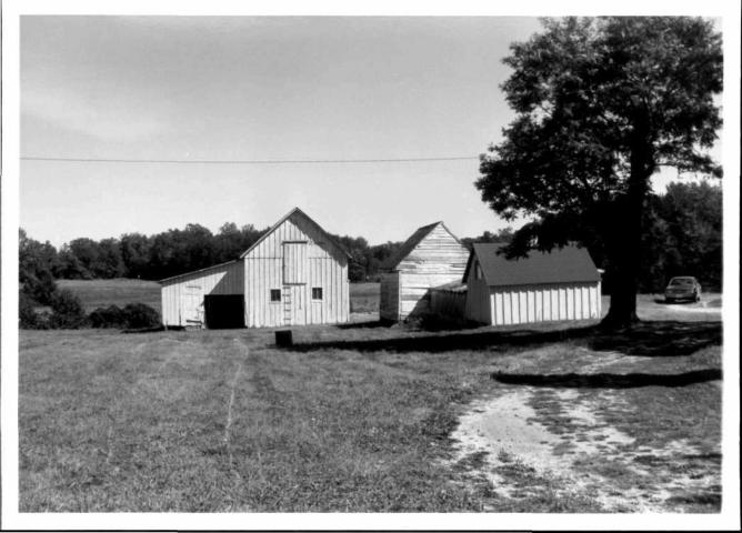
The Furgang Farm consists of a gable-roof frame farmhouse in a complex of farm bui ld ings which range in date from the mid-nineteenth century to 1926. The two-and-one-hal f - s t o r y house (1897) is T-shaped, a variant of the gable-front-and-wing p lan. The pr incipal south gable end is pedi-mented, and has ornamental sh ing l ing . Entrance on the south facade, is in the f i r s t bay of the wing, sheltered by a one story porch with turned posts and fan brackets. The east gable end of the wing is also pedimented and has ornamental sh ing l ing , as well as a one-story project ing bay. Behind the house to the northeast are two contemporary outbui ld ings; a frame gable-roof summer k i tchen, and a smaller milk house. Farther to the east is a chicken house and shed, attached to an older (mid-nineteenth century) gable-roof s t ruc tu re ; the l a t t e r s t ructure is sided with riven random-width clapboard. An early twent ieth century carriage house and tobacco barn (1926) complete the complex of outbui ld ings.
Descr ipt ion
The Furgang Farmhouse is a two-and-one-hal f - s to ry frame T-shaped dwell i n g . Constructed at the end of the nineteenth century, i t is a la te V ic tor ian bui ld ing with Queen Anne decorative elements, of the gable- f ront-and-wing p lan. I t is located on level farmland on the northwest side of the Popes Creek l i ne of the old Baltimore and Potomac Rai l road. The house stands in a c luster of farm bui ld ings and faces roughly south toward the r a i l road.
Pr incipal elevat ion is the south, and consists of the gable f ront and wing which face the ra i l road t rack . The front gabled section is two bays by one bay, c i rca 34 by 16 f e e t . The f i r s t bay of the south elevation is the (16 foot) pedimented gable end; i t i s l ighted by a double 1/1 window in the f i r s t and second s to r i es . Above the windows, the boxed cornice forms a pediment; the tympanum is sided with f ishscale shingles. The gable f ront i s fu r ther ornamented by panels of f ishscale shingles below and between the two sets of double windows.
Recessed eight feet from the south gable end, the two bay wing extends 18 feet to the east. Entrance is in the f i r s t bay of i t s south facade, through a door with single-pane transom, separated from the casing by a s ingle band of bead-and-reel molding. The door i t s e l f is glazed with a s ing le large pane of glass above two molded panels. Shelter ing the doorway and f i l l i n g the en t i re corner formed by the gable f ront and wing is a one-story h ip- roof porch; i t s turned posts have fan brackets, and i t rests on a br ick foundation.

8. Significance Survey No. p .G . #82A-23
Period prehistoric 1400-1499 1500-1599 1600-1699
— 1700-1799 _X_ 1800-1899 - X - 1 9 0 0 -
Areas of Significance—Check and justify below archeology-prehistoric community planning landscape architecture archeology-historic
X agriculture X architecture
art commerce communications
conservation economics education engineering
law literature military music
exploration/settlement philosophy industry politics/government invention
religion science sculpture social/ humanitarian theater transportation
X. other (specify) local History
Specific dates 1897-1926 Builder/Architect Edward Pyles
check: Applicable Criteria: A B _X_C D and/or
Applicable Exception: _A _B _C _D _E _F _G
Level of Significance: national state local
Prepare both a summary paragraph of significance and a general statement of history and support.
Signif icance
The Furgang farmstead is a good example of a Prince George's County farm complex; i t consists of a f ine la te Victor ian farmhouse in a set t ing of functional farm bu i ld ings, representing a continuous period of use from before the construction of the house to a generation afterwards. Such a complex of bui ldings is increasingly rare in developing Prince George's County; i t is an important and representative example of three generations of a modest but successful family farm.
History and Support
The Furgang farm is a good example of a late Victorian farmhouse in a contemporary farm setting. It stands with a complex of outbuildings, which represent a continuous period of use, from before the construction of the house to a generation afterwards.
The house was built in 1897 by Morris Furgang on a tract of land called "Boone's Chance" where earlier had stood the farmstead of Horatio ClubbJ Morris Furgang, born of German and Russian parents, came to the United States as an infant in the 1840's. As a young man he worked on the construction of the Popes Creek Line of the Baltimore and Potomac Railroad through southern Prince George's County, and later became an engineer for the railroad line. In 1874 he married Laura, one of the daughters of Enoch Duley, a prominent landowner who lived and farmed in the area now known as Duley Station.2 In 1887 Laura Duley Furgang purchased from the estate of Horatio Clubb 45 acres of "Boone's Chance", which was a short distance south of Enoch Duley's farm, on the Popes Creek line.3 In 1897 the Furgangs began construction of the house a short distance northwest of and fronting on the railroad tracks. The house was built by Edward Pyles, a relative by marriage. During the construction of the new house, the Furgangs lived in a small one-room structure which remained from the old Clubb farm. This structure, known to the family as the "old house", still

9. Major Bibliographical References survey N O . P . G . # 8 2 A - 2 3
See Chain of Title See notes, Item #8
10. Geographical Data 23.5 acres Acreage of nominated property _
Quadrangle name Brandywine, Section B
UTM References d 0 N O T c o m p l e t e UTM r e f e r e n c e s
J I I • l • , l I i I i I i i I
Tax Map 127, parcel 187 Quadrangle scale.
B
Zone Easting Northing
c L U 1 1 . I • • I I • I i I i i I E L _ U I 1 • 1 • • i Li 1 i GLU I I • I , , I | i I i
_L _L Zone Easting Northing
D L J I I • I • • I I i 1 i 1 i i F L U _L _L J—L
J I H LL J _ L 1 , 1 , 1 J__L
Verbal boundary description and justification
List all s tates and counties for properties overlapping state or county boundaries
state code county code
state code county code
11 . Form Prepared By
name/title Susan 6. Pear l , Pr inc ipal Invest igator , H is tor ic Survey Project
organization His to r i c Preservation Commission date
September 1986
c/o County Planning D1v., M-NCPPC street & number 14741 Gov. Oden Bowie Dr ive, Rm. 4010 telephone 952-3521
city or town Upper Marlboro,
state Maryland 20772
The Maryland Historic Sites Inventory was officially created by an Act of the Maryland Legislature to be found in the Annotated Code of Maryland, Article 41, Section 181 KA, 1974 supplement.
The survey and inventory are being prepared for information and record purposes only and do not constitute any infringement of individual property rights.
return to: Maryland Historical Trust Shaw House 21 State Circle Annapolis, Maryland 21401 (301) 269-2438
PS-2746

MARYLAND HISTORICAL TRUST Survey Ho. PG:82A-23 STATE HISTORIC SITES INVENTORY FORM
Description (continued) Section 7 Page 2
The wing is two bays by one bay, c irca 18 by 15 fee t . I ts east gable end has a pediment ident ica l to that of the south gable end: i t s tympanum is sided with f ishscale shingles. The second story is l ighted by one 2/2 window, while the f i r s t story is f i l l e d with a one-story semi-octagonal pro ject ing bay. There is a 1/1 window in each of the three faces of th i s bay; the surfaces above and below the windows are panelled.
The bui ld ing is covered with German siding of Georgia pine, painted whi te . Windows are generally 2/2 double hung sash; they have pla in board surrounds with project ing upper bead, and dark green louvered shut ters . There is a plain f r ieze band beneath the cornice, and corner posts are crested at the f r ieze with an applied jigsawn ornament.
The roof is covered with green asphalt shingle; the cornice is boxed wi th crown molding. There are two corbelled brick chimneys; one is centered at the ridge of the westerly f ront gabled sect ion, and the other r ises at the ridge between f i r s t and second bays of the wing. The foundat ion is of b r i ck . There is a basement space (excavated in the 1930's) under the north part of the front-gabled sect ion.
In te r io r plan consists of two parlors in the front gabled sect ion, the rear (norther ly) of which was the or ig inal k i tchen. The wing is composed of s t a i r ha l l and alcoved dining room. Door and window surrounds are m u l t i -band molding with bul ls-eye corner blocks. The pla in wooden mantels have been removed from the stove f i replaces and are stored in the carriage house. The open s t r ing staircase has turned newel and balusters , a panelled spandrel and pla in stairends. The or ig ina l kitchen has been converted into a study and bathroom. The rear one-story porch which f i l l e d the inner north corner between gable f ront and wing has been enclosed to form a modern k i tchen. At the north end of the ki tchen, a small shed-roof addi t ion has been constructed to serve as an entry to the basement space; i t is sided with rectangular shingles.
A white picket fence forms east and north boundaries of the immediate grounds of the house, separating the dwell ing and pr incipal outbui ldings from the other farm bu i ld ings . A summer kitchen and a milk house, roughly contemporary with the house, stand close to the dwelling in th i s p a r t i a l l y fenced complex.
The summer kitchen is a frame gable-roof s t ruc ture , 10 feet by 12 fee t . I t was o r i g i na l l y board-and-batten and is now covered with wall board. There is a t a l l i n t e r i o r corbelled brick chimney in the north gable end, which served a cooking f i rep lace . The roof is covered with green asphalt sh ingle, and the bui ld ing rests on a concrete foundation. Entrance is through an of f -center door in the south gable end; there is one window in the east facade.

MARYLAND HISTORICAL TRUST Survey No. P.G. 82A-23 STATE HISTORIC SITES INVENTORY FORM Description (continued) Section 7 Page 3
East of the k i tchen, and s t i l l w i th in the picket enclosure is a small (6 feet by 8 feet) milk house. I t is sided with horizontal board, and i t s gable roof is covered with wooden shingles. I t rests on a br ick foundation. Entrance is through a door (made of diagonally placed boards) in the south gable end. This small dairy bui ld ing had troughs (now removed) along i t s wa l l s , in to which water was run from the pump which is located immediately to the west.
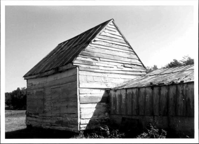
Extending to the east, outside of the picket enclosure is a complex of farm bu i ld ings: a small gable-roof chicken house with a long shed attached to i t s north w a l l , and, attached to the north end of the shed, a much older (ear ly to mid-nineteenth century) one-and-one-half-story gable-roof struct u r e . This l a t te r s t ruc tu re , known as the "old house", is c i rca 16 by 14 fee t , constructed of hand-riven random-width clapboard, some as wide as 12 inches. I t s two-bay main south facade has one single-sash (six-pane) window and a door of wide ver t i ca l planks. The i n t e r i o r is one room, with an open s ta i r (not old) along the east gable end; i t leads to a l o f t above. The floorboards of the l o f t are supported by beams, some of which are hand cut and some c i rcu lar sawn. The bui ld ing was moved from i t s or ig ina l locat i on closer to the ra i l r oad , and now rests on sections of logs. The roof is of standing seam metal . Windows on the north facade and in the east gable end have been closed s t r u c t u r a l l y . There is a large batten door in the east gable end.
East of the "old house", across a farm lane, stands a one-and-one-ha l f - s to ry early twent ieth-century carriage house. I ts lower story is sided with plain ver t ica l board, and the upper story with board-and-batten. I t s gable roof is covered with green asphalt shingle. I t rests on a brick foundat ion. There is a shed-roof addit ion to the north ( r e a r ) .
Between the "old house" and the carriage house, a farm lane runs north toward a small shed and a tobacco barn. The shed has gable roof , board-and-batten s id ing, double doors in i t s south gable end, and a shed addit ion on the east. The barn ( bu i l t in 1926) has a gable roof and a shed addit ion in the rear (nor th) . I t is sided with ver t ica l boards; i t s south facade is painted red, and i t s other sides are unpainted. The roof is of standing seam t i n .

MARYLAND HISTORICAL TRUST Survey Ho. PG:82A-23 STATE HISTORIC SITES INVENTORY FORM c_ r c • • .=. / • JN S e c t i o n 8 Page 2 S t a t e m e n t of S i g n i f i c a n c e ( c o n t i n u e d ) • t —
stands northeast of the 1897 dwel l ing. After the new dwelling was comp le ted, the "old house" was moved back (north) from the ra i l road and placed on log p ie rs . I t is the sole early nineteenth century st ructure remaining from the Clubb farm.4
Members of the Furgang family have l ived in the house since i t s comp le t ion in 1897; Morris Furgang continued to work as an engineer for the r a i l r o a d , and boarded the t ra in at a special stop in his f ron t yard. After the deaths of Morris and Laura Furgang in the 1920's, the i r farm was the home of the i r son, Ernest Furgang, who was on the teaching s ta f f of the neighboring "House of Reformation for Colored Boys". I t is s t i l l the house of his descendants.^
The farmhouse is a good example of the gable-front-and-wing plan of la te Victor ian vernacular domestic a rch i tec ture . I t is dist inguished by molded panels and decorative shingl ing which add variety to the wall surfaces, and is one of the best examples of i t s type in Prince George's County. Although there have been i n t e r i o r a l terat ions ( e . g . , removal of mantels, conversion of the kitchen wing, and enclosing of the rear porch), the pr incipal facades retain the i r or ig inal appearance. The s igni f icance of the house l i es in the fact that i t is part of a complex of funct ioning farm bu i ld ings: the contemporary cook-house (or summer kitchen) and milk house wi th in a few steps of the dwel l ing, the somewhat l a te r chicken house and carriage house, and the much ea r l i e r "old house." This group of bu i l d ings as a whole re f lec ts the agr icu l tu ra l heritage of Prince George's County. Such a complete farm complex is increasingly rare in developing Prince George's County; i t is an important and representative example of three generations of a modest but successful family farm.
Notes
1 Prince George's County Tax Assessments, 1888-1900; c f . also G.M. Hopkins, Atlas of Prince George's County. 1878.
2 Census for Prince George's County, Brandywine D i s t r i c t , 1880, 1900; interview with members of Furgang fami ly , 1985, 1986.
3 Prince George's County Deed WAJ #2:269.
* Prince George's County Tax Assessments 1897; interview with members of Furgang fami ly .
5 Interview with members of Furgang fami ly ; Prince George's County Deeds #224:245; #4367:36; #4409:764.

Chain of T i t l e
Furgang HetrsB- F«-r** P.G. #82A-23
4409:764 23 Aug 1974 Deed
4367:36 8 Apr i l 1974 Deed
John M. Furgang, Leonard D. Furgang, and Francis E. Furgang to Katharine E. Furgang Gardner; 27 acres -23.5 acres by #224:245 and 3.5 acres by #119:412 - same land conveyed by Francis E. Furgang, (representat ive of Blanche E. Furgang, Adm. #22,532, CMH#248:001) by #4367:36.
Francis E. Furgang, (representat ive of Blanche E. Furgang, Adm. #22,532), to Katharine E. Furgang Gardner, John M. Furgang, Leonard D. Furgang, and Francis E. Furgang, parcel 1 o r ig ina l l y containing 70 acres, and parcel 2 containing 41 acres acquired by #224:245.
#22532 1973 Admin.
Blanche E. Furgang, deceased 1973; Francis E. Furgang appointed her representat ive.
#10456 1953 Admin.
224:245 24 Nov 1924 Deed
WAJ^2:269 6 Jan 1881 Deed
EWB*I:183 12 Dec 1854 Indenture
Ernest D. Furgang, deceased 1953; his real estate includes "home place" ca. 43 acres which he acquired by #224:245. Widow, Rlanche E. Furgang appointed representat ive.
Morris Furgang, husband of Laura A. Furgang, deceased, Blanche E. Soper and Clarence S. Soper, her husband, to Ernest D. Furgang; 45-3/4 acres (noted on plat as 45-2/3 acres in WAJ#2:268), part of "Boons Chance," same land conveyed to Laura A. Furgang by WAJ#2:269.
Wil l iam A. Jarboe, executor of Horatio Clubb estate to Laura A. Furgang, 45-3/4 acres cal led part of "Boons Chance" (WAJ#1:495).
Charles Ridgely Jun. and his wife Mary Ridgely to James Ritchie in t rus t for the use and benefit of Elizabeth B. Clubb wife of Horatio Clubb, 150-3/8 acres, part of a t rac t of land cal led "Boons Chance."

PG:82A-23
MARYLAND HISTORICAL TRUST
INVENTORY FORM FOR STATE HISTORIC SITES SURVEY
NAME HISTORIC
Club Farm AND/OR C O M M O N
LOCATION STREETS. NUMBER
Old I n d i a n Head Road & Penn C e n t r a l t r a c k s CITY. TOWN
C h e l t e n h a m VICINITYOF STATE
Mary land
CONGRESSIONAL DISTRICT
COUNTY
P r i n c e G e o r g e ' s
•
CLASSIFICATION
CATEGORY
/DISTRICT
V^BUILDING(S)
— STRUCTURE
_SITE
—OBJECT
OWNERSHIP
—PUBLIC
XPRIVATE
—BOTH
PUBLIC ACQUIS IT ION
_ I N PROCESS
_BEING CONSIDERED
STATUS
^OCCUPIED
—UNOCCUPIED
—WORK IN PROGRESS
A C ^ . S I B L E —YES RESTRICTED
_ V € S UNRESTRICTED
^ N O
. PRESENT USE
^ A G R I C U L T U R E — M U S E U M
— C O M M E R C I A L
— EDUCATIONAL
— ENTERTAINMENT
— G O V E R N M E N T
— I N D U S T R I A L
— MILITARY
^ P R I V A T E RESIDENCE
- . .REUGIOUS
— SCIENTIFIC
—TRANSPORTATION
—OTHER
OWNER OF PROPERTY NAME
Blanche E. Furgang STREET Si NUMBER
Telephone #:
STATE , z ip code Maryland
« • CITY. TOWN
Upper Marlboro VICINITYOF
LOCATION OF LEGAL DESCRIPTION COURTHOUSE
REGISTRY OF DEEDS.ETC
Liber #: Folio #:
Prince George's County Courthouse STREETS. NUMBER
CITY. T O W N STATE
Upper Marlboro 2 REPRESENTATION IN EXISTING SURVEYS
Maryland
TITLE
DATE
—FEDERAL —STATE — C O U N T Y —LOCAL
DEPOSITORY FOR
SURVEY RECORDS
CITY. T O W N STATE

PG:82A-23
DESCRIPTION
./EXCELLENT
J.GOOD _FAIR
CONDITION
—DETERIORATED
_RUINS
_UNEX POSED
CHECK ONE
Y.UNALTERED
—ALTEREO
CHECK ONE
—ORIGINAL SITE
_MOVED DATE-
DESCRIBE THE PRESENT AND ORIGINAL (IF KNOWN) PHYSICAL APPEARANCE
This is a better-than-average, two-story frame farmhouse of Victorian design. Part of the house may be earlier, as there was a Club farm here during the mid-19th Century. There are a number of frame farm buildings on the property. (Site not examined closely at time of survey.)
CONTINUE ON SEPARATE SHEET IF NECESSARY

PG:82A-23
IICANCE
PERIOD
—PREHISTORIC
— 1400
— 1 5 0 0
_ 1 6 0 0
— I^OO
J ? 1 8 0 0
— 1 9 0 0
1499
1599
1699
1799
1899
AREAS OF SIGNIFICANCE - CHECK AND JUSTIFY BELOW
ARCH EOLUUY-PRE HISTORIC
ARCHEOLOGY HISTORIC
AGRICULTURE
ARCHITECTURE
ART
— C O M M E R C E
— C O M M U N I C A T I O N S
— C O M M U N I T Y PLANNING
—CONSERVATION
— E C O N O M I C S
—EDUCATION
_ ENGINEERING
— EXPLORATION/SETTLEMENT
—INDUSTRY
— I N V E N T I O N
—LANDSCAPE ARCHITECTURE
— LAW
—LITERATURE
—MIL ITARY
— M U S I C
—PHILOSOPHY
—POLITICS/GOVERNMENT
— RELIGION
—SCIENCE
—SCULPTURE
— S O C I A L / H U M A N I T A R I A N
—THEATER
—TRANSPORTATION
—OTHER (SPECIFY)
SPECIFIC DATES BUILDER/ARCHITECT
STATEMENT OF SIGNIFICANCE
The map of 1861 shows the "H. Club" farm here. By 1878 the Pope's Creek branch of the Baltimore & Potomac RR had been built in front of the farm, then owned by the "Club heirs".
CONTINUE ON SEPARATE SHEET IE NECESSARY

PG:82A-23
IMAJOR BIBLIOGRAPHICAL REFERENCES
CONTINUE ON SEPARATE SHEET IF NECESSARY
IGEOGRAPHICAL DATA ACREAGE OF NOMINATED PROPERTY
VERBAL BOUNDARY DESCRIPTION
.-> ' . • - i , • - - i -^ ...
LIST ALL STATES AND COUNTIES FOR PROPERTIES OVERLAPPING STATE OR COUNTY BOUNDARIES
STATE COUNTY
STATE COUNTY
\ ,
UJFORM PREPARED BY NAME/TITLE
Michael F. Dwyer, Senior Park His tor ian ORGANIZATION
M-NCPPC STREETS. NUMBER
8787 Georgia Ave. CITY OR TOWN
Si lver Spring
DATE
9/19/74 TELEPHONE
589-1480 STATE
Maryland
The Maryland Historic Sites Inventory was officially created by an Act of the Maryland Legislature, to be found in the Annotated Code of Maryland, Article 41, Section 181 KA, 1974 Supplement.
The Survey and Inventory are being prepared for information and record purposes only and do not constitute any infringement of individual property rights.
RETURN TO: Maryland Historical Trust The Shaw House, 21 State Circle Annapolis, Maryland 21401 (301) 267-1438


Chain of T i t l e
Furgang Farm P.G. #82A-23
4409:764 John M. Furgang, Leonard D. Furgang, and Francis E. 23 Aug 1974 Furgang to Katharine E. Furgang Gardner; 27 acres -Deed 23.5 acres by #224:245 and 3.5 acres by #119:412 - same
land conveyed by Francis E. Furgang, ( representa t ive of Blanche E. Furgang, Adm. #22,532, CMH#248:001) by #4367:36.
4367:36 Francis E. Furgang, ( representat ive of Blanche E. 8 Ap r i l 1974 Furgang, Adm. #22,532), to Katharine E. Furgang Deed Gardner, John M. Furgang, Leonard D. Furgang, and
Francis E. Furgang, parcel 1 o r i g i n a l l y conta in ing 70 acres, and parcel 2 conta in ing 41 acres acquired by #224:245.
#22532 Blanche E. Furgang, deceased 1973; Francis E. Furgang 1973 appointed her representa t ive . Admin.
#10456 Ernest D. Furgang, deceased 1953; h is real estate 1953 includes "home place" ca. 43 acres which he acquired by Admin. #224:245. Widow, Blanche E. Furgang appointed repre
sen ta t i ve .
224:245 Morris Furgang, husband of Laura A. Furgang, deceased, 24 Nov 1924 Blanche E. Soper and Clarence S. Soper, her husband, to Deed Ernest D. Furgang; 45-3/4 acres (noted on p la t as
45-2/3 acres in WAJ#2:268), part of "Boons Chance," same land conveyed to Laura A. Furgang by WAJ#2:269.
WAJ #2:269 Wi l l iam A. Jarboe, executor of Horatio Clubb estate to 6 Jan 1881 Laura A. Furgang, 45-3/4 acres ca l led part of "Boons Deed Chance" (WAJ#1:495).
EWB #1:183 Charles Ridgely Jun. and his wife Mary Ridgely to James 12 Dec 1854 Ri tch ie in t r us t for the use and benefi t of El izabeth Indenture B. Clubb wife of Horat io Clubb, 150-3/8 ac res , part of
a t r a c t of land ca l led "Boons Chance."


PG#82A-23
Furgang Farm Prince George's County, MD Susan G. Pearl September 1986 farmhouse, southeast 3/4 elevation Neg: Md. Hist. Trust, Annapolis, MD


PG#82A-23
Furgang Farm Prince George's County, MD Susan G. Pearl September 1986 Farmhouse and outbuildings, from east Neg: Md. Hist. Trust, Annapolis, MD


PG#82A-23
Furgang Farmhouse Prince George's County, MD Susan G. Pearl September 1986 Stair Neg: Md. Hist. Trust, Annapolis, MD


PG#82A-23
Furgang Farmhouse Prince Goerge's County, MD Susan G. Pearl September 1986 Interior molding Neg: Md. Hist. Trust, Annapolis, MD


P.G. #82A-23 Furgang Farm Prince George's County, MD Susan G. Pearl February 1985 South elevation Neg: Md. Hist. Trust, Annapolis, Md.


PG#82A-23
Furgang Farm Prince George's County, MD Susan G. Pearl September 1986 Stairhall from south Neg: Md. Hist. Trust, Annapolis, MD


PG#82A-23
Furgang Farm Prince George's County, MD Susan G. Pearl September 1986 Milk house from south Neg: Md. Hist. Trust, Annapolis, MD


PG#82A-23
Furgang Farm Prince George's County, MD Susan G. Pearl September 1986 "Old House", east gable end Neg: Md. Hist. Trust, Annapolis, MD


PG#82A-23
Furgang Farm Prince George's County, MD Susan G. Pearl September 1986 Milk house, southwest Neg: Md. Hist. Trust, Annapolis, MD


PG#82A-23
Furgang Farm Prince George's County, Susan G. Pearl Scehfcreneshed "old house" & Carriage
N e r M l f H i s t ^ u s t , Annapolis, MD


PG#82A-23
Furgang Farm prince George's County, MD Susan G. Pearl September 1986 Summer kitchen from south Neg: Md. Hist. Trust, Annapolis, MD

PG#82A-23
Furgang Farm Prince George's County, MD Susan G. Pearl September 1986 "Old House" from northwest Neg: Md. Hist. Trust, Annapolis, MD


PG#82A-23
Furgang Farm Prince George's County, MD Susan G. Pearl September 1986 Carriage house, "old house" and chicken
shed from west Neg: Md. Hist. Trust, Annapolis, MD


PG#82A-23
Furgang Farm Prince George's County, MD Susan G. Pearl September 1986 Barn, southwest 3/4 elevation Neg: Md. Hist. Trust, Annapolis, MD


PG#82A-23


P.G.#32A-23
Furgang Farm Prince George's County, MD Susan G. Pearl February 1985 West elevation Neg: Md. Hist. Trust, Annapolis, MD


P.G. #82A-23
Furgang Farm Prince George's County, MD Susan G. Pearl February, 1985 East elevation . M n
Neg: Md. Hist. Trust, Annapolis, MD


P.G.#82A-23
Furgang Farm Prince George's County, MD Susan G. Pearl February 1985 Outbuilding, northeast Neg: Md. Hist. Trust, Annapolis, MD


P.G.#82A-23
Furgang Farm Prince George's County, MD Susan G. Pearl February 1985 North elevation Neg: Md. Hist. Trust, Annapolis, MD