maryland department of agriculture - chesapeake … department of agriculture . ... agricultural...
TRANSCRIPT

1
2
Maryland Department of Agriculture
This Quality Assurance Project Plan is submitted to the US Environmental Protection Agency Chesapeake Bay Program Office as part of the FFY2011 Chesapeake Bay Regulatory and Accountability Program (CBRAP) grant funded under Section 117 of the Clean Water Act (CWA): the Chesapeake Bay Program. The QAPP is required as part of Objective #11: Agricultural Watershed Implementation Plan (WIP) Coordination Introduction/Project Description The Maryland Department of Agriculture reports agriculture best management practice implementation data to the Maryland Department of Environment annually. This information is then provided to the Chesapeake Bay Program office for use in the Chesapeake Bay Program Watershed Model. The following outlines documentation of data sources and any analyses that are done by the Maryland Department of Agriculture for each best management practice for which implementation is tracked, compiled, and analyzed prior to submission to the Maryland Department of Environment. The Maryland Department of Agriculture’s implementation tracking data currently includes data from the Maryland Agricultural Water Quality Cost-Share program and MDA’s Conservation Tracker which captures BMPs implemented under State and Federal programs. The Maryland Department of Agriculture acknowledges that many farmers implement best management practices on their own outside of federal, state, and local programs which we do not have the ability to capture and report in the implementation tracking table. Maryland is initiating a comprehensive program, through third party data collection, to inventory the significant number of BMP’s that farmers have installed on their farms without technical or financial assistance. This under reporting of practices fails to accurately reflect the conservation efforts applied and how water quality benefits are measured. These previously unreported practices are not included in Maryland’s Conservation Tracker database and have not counted towards our nutrient reduction crediting in the Bay model. Of greatest value are those BMP’s implemented since 2006, that meet existing practice standards, when the model was last calibrated. This work will help to further our Conservation planning goals and assist in inventory existing resource concerns. MDA is working collaboratively with other Bay State partners to develop a definition and reporting protocol for voluntary BMPs. Funded by NRCS and led by the National Association of Conservation Districts, the project will establish a means by which to credibly identify and track BMPs implemented outside state and federal cost share programs.
Maryland will also be initiating a pilot program where soil conservation districts would conduct on farm walking inventories of all of the current practices farmers have installed without incentives. An on-farm nutrient calculation tool will be utilized to assess the farm and to analyze additional management options. EPA CBP needs to set BMP efficiencies for practices that provide water quality protection but do not meet NRCS standards and specifications.
In 2011 the Upper Chester River Showcase Watershed Assessment was conducted and quantified the strong conservation commitments of the farm community as well as the extent that farmers install conservation practices on their own outside of government cost share assistance. Within the 23,000 acre watershed farmers had installed over 931 Best Management Practices of which 320 or 33% were previously unreported. Also in 2011 the Howard Soil Conservation District is inventorying over 250 farms which will assess all the existing practices that have never been documented and reported as providing a water quality benefit. In 2012 Baltimore Soil Conservation District will be utilizing a similar approach to report on the extent of their non cost shared Best Management Practice implementation. A Memorandum of Understand between MDA and NRCS, USDA is in place that defines the roles and responsibilities of each agency and directs their mutually cooperative efforts to achieve the conservation and protection of soil, water and related resources through the optimum use of state and federal resources. The MOU can be found at http://www.mda.state.md.us/pdf/macs_manual/4/1_mou.pdf.

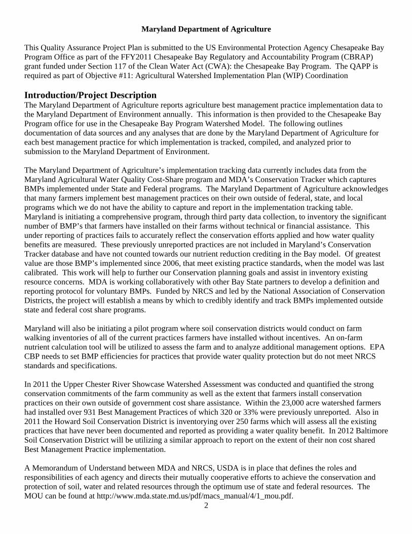
Organization
Structure
3

4

5

6 6
7

8

9
Soil Conservation District Offices
ALLEGANY SCD Craig Hartsock, District Manager 301-777-1747 12407 Naves Cross Road, NE Ext. 3 Cumberland, MD 21502-8212 Fax: 301-777-7632 ANNE ARUNDEL SCD J. Stein, District Manager 410-571-6757 Heritage Office Center Fax: 410-224-4586 2662 Riva Road, Ste. 150, MS #7001 Annapolis, MD 21401-7377 BALTIMORE COUNTY SCD J. Ensor, District Manager 410-527-5920 1114 Shawan Road, Ste. 4 Ext. 3 Cockeysville, MD 21030 Fax: 410-527-1528 CALVERT SCD W. Clark, District Manager 410-535-1521 65 Duke St., Kaine Bldg., Rm. 106 Ext. 3 P.O. Box 657 Fax: 410-535-0591 Prince Frederick, MD 20678 CAROLINE SCD J. Shepard, District Manager 410-479-1202 9194 Legion Road, Ste. 3 Ext. 3 Denton, MD 21629 Fax: 410-479-2069 CARROLL SCD E. Null, District Manager 410-848-8200 698 J Corporate Center Court Ext. 3 Westminster, MD 21157 Fax: 410-848-8258 CATOCTIN SCD D. Remsburg, District Manager 301-695-2803 92 Thomas Johnson Drive Ext. 3 Ste. 230 North Amber Fax: 301-694-0270 Frederick, MD 21702 CECIL SCD C. Hayes, District Manager 410-398-4411 105 Chesapeake Blvd., Ste. B-3 Ext. 3 Elkton, MD 21921 Fax: 410-392-6530 CHARLES SCD L. Dieguez, District Manager 301-934-9588 101 Catalpa Drive, Ste. 106C Ext. 3 P.O. Box 269 Fax: 301-934-2845 LaPlata, MD 20646 DORCHESTER SCD J. Newcomb, District Manager 410-228-5640 501 Court Lane, Room 213 Ext. 3 Cambridge, MD 21613 Fax: 410-228-0078 FREDERICK SCD D. Remsburg, District Manager 301-695-2803 92 Thomas Johnson Drive Ext. 3
Ste. 230 North Amber Fax: 301-694-0270 Frederick, MD 21702 GARRETT SCD S. Sanders, District Manager 301-334-6950 1916 Maryland Hwy., Ste. C Ext. 3 Mountain Lake Park, MD 21550 Fax: 301-334-6952 HARFORD SCD W. Tharpe, District Manager 410-838-6181 19 Newport Drive, Ste. 103 Ext. 3 Forest Hill, MD 21050-1666 Fax: 410-638-8034 HOWARD SCD B. Ensor, District Manager 410-489-7987 708 Lisbon Center Drive, Ste. E Fax: 410-489-9120 Woodbine, MD 21797 KENT SCD K. Miller, District Manager 410-778-5150 122 Speer Road, Ste. 4 Ext. 3 Chestertown, MD 21620 Fax: 410-778-4700 / 0709 MONTGOMERY SCD D. Plummer, District Manager 301-590-2855 Ag Activity Center Fax: 301-590-2849 18410 Muncaster Road Derwood, MD 20855 PRINCE GEORGE’S SCD D. Bourdon, District Manager 301-574-5162 5301 Marlboro Race Track Road Ext. 3 Upper Marlboro, MD 20772 Fax: 301-574-5156 QUEEN ANNE’S SCD Colin Jones, District Manager 410-758-3136 211 East Water Street Ext. 3 Centreville, MD 21617 Fax: 410-758-3820 ST. MARY’S SCD B. Young, District Manager 301-475-8402 / 5856 26737 Radio Station Way, Ste. B Ext. 3 Leonardtown, MD 20650 Fax: 301-475-8391 SOMERSET SCD L. Fykes, District Manager 410-651-1575 30730 Park Drive Ext. 3 Howard H. Anderson Ag Bldg. Fax: 410-651-0598 Princess Anne, MD 21853 TALBOT SCD C. Zinter, District Manager 410-822-1577 28577 Marys Court, Ste. 3 Ext. 3 Easton, MD 21601 Fax: 410-822-3162 WASHINGTON COUNTY SCD E. Weibley, District Manager 301-797-6821

10
1260 Maryland Avenue, Ste. 101 Ext. 3 Hagerstown, MD 21740 Fax: 301-733-5894 WICOMICO SCD K. Keenan, District Manager 410-546-4777 2322-B Goddard Parkway Ext. 3 Salisbury, MD 21801 Fax: 410-860-9819 WORCESTER SCD D. Jones, District Manager 410-632-5439 304 Commerce Street Ext. 3 Snow Hill, MD 21863-1008 Fax: 410-632-2732

11
Email addresses – Soil Conservation District Managers Please note not all managers’ use or check their email regularly. Use accordingly. This information is provided in response to requests. Updates will be provided as we are made aware of changes. Allegany Soil Conservation District..............................................................................chartsock@atlanticbbn.net Anne Arundel Soil Conservation District................................................................................jim.stein@aascd.org Baltimore County Soil Conservation District.....................................................jbensor@baltimorecountymd.gov Calvert Soil Conservation District....................................................................................... [email protected] Caroline Soil Conservation District...........................................................................ShepardRJ@mda.state.md.us Carroll Soil Conservation District .................................................................................... [email protected] Catoctin Soil Conservation District..................................................................................dremsburg@comcast.net Cecil Soil Conservation District ..................................................................................charleshayes@cecilscd.com Charles Soil Conservation District .............................................................................. [email protected] Dorchester Soil Conservation District................................................................... [email protected] Frederick Soil Conservation District ................................................................................dremsburg@comcast.net Garrett Soil Conservation District ............................................................................... [email protected] Harford Soil Conservation District...............................................................................tharpewr@mda.state.md.us Howard Soil Conservation District .........................................................................rensor@howardcountymd.gov Kent Soil Conservation District............................................................................................. [email protected] Montgomery Soil Conservation District .......................................... [email protected] Prince George’s Soil Conservation District...............................................................................pgscd@verizon.net Queen Anne’s Soil Conservation District ...................................................................... [email protected] St. Mary’s Soil Conservation District .................................................................... [email protected] Somerset Soil Conservation District .............................................................................. [email protected] Talbot Soil Conservation District ...................................................................................zintercs@mda.state.md.us Washington County Soil Conservation District .....................................................................wcscd1@verizon.net Wicomico Soil Conservation District....................................................................... [email protected] Worcester Soil Conservation District .............................................................................jonesda@mda.state.md.us

Quality Assurance Objective: The Maryland Agricultural Water Quality Cost-Share Program (MACS) will strive to provide 100% accuracy in reporting the Agricultural Best Management Practices (BMPs) installed with MACS Cost-Share funds in Maryland. The BMPs will be subjected to a rigorous Quality Assurance procedure through a random sample spot checking/status review procedure each year. Outside sources of information are utilized to verify data accuracy. Application Data Accuracy:
12

13
Applications for Cost Share Assistance: Applications will be reviewed to assure that the practices are needed, there is a positive environmental impact, the limits and parameters outlined in state law and regulations and per practice criteria as delineated in the MACS Manual are met. SCDs evaluate alternative NPS treatment options, recommend appropriate BMPs to solve water quality problems, design and supervise construction of the practices, and develop maintenance plans. Through this process, they help assure the technical integrity and eligibility of the BMP proposed for cost-share. The SCDs role is ongoing, since they also conduct technical certifications and periodic inspections during the maintenance life of MACS projects. Applications are reviewed by trained qualified professionals and if the criteria are met they are approved for submission to the Board of Public Works for funding approval. The Board of Public Works consists of the Governor, the Comptroller and the Treasurer of the State of Maryland. Upon their approval the applicant is informed they may proceed with the planning, design and construction of the BMP. Please refer to the following link: http://www.mda.state.md.us/resource_conservation/financial_assistance/macs/index.php The data on the application is recorded in a database maintained by the Maryland Department of Agriculture (MDA). This includes ownership, farm information, watershed information, practice information, requested cost share information, expected costs and design information if needed. The data is initially entered by one MACS staff specialist and is reviewed by a second MACS specialist as it moves through the review and approval process. Outside sources of information are utilized to assure accurate and correct information. Information sources used for verification include tax maps, watershed maps, and aerial photography. Practice Quality Control: There is a multiple level of review and approval in the planning, design, construction and approval process. Field staff includes trained conservation planners, technicians, and engineers. USDA, NRCS technical standards are used as a basis for technical adequacy and USDA, NRCS provides technical oversight for practice design and implementation. Detailed job approval authorities outline the levels of work and expertise that are needed in each phase of the planning, design and installation. On-site reviews, spot checks and status reviews are conducted regularly to assure the BMPs installed meet standards and specifications. Quality assurance is provided by on-site reviews, multiple levels of review and approval within approved job approval levels, annual spot checks, field office quality assurance reviews and annual status reviews are conducted on at least 10% of all BMPs installed throughout their maintenance life. Claim for Payment Quality Control: Bills are compiled and submitted to the MACS office for review. The Claim for Payment is reviewed for completeness. Costs are compared with the original application and against the approved flat rates for the County. Flat rates are established for each practice component based on local costs. These are reviewed annually and updated as needed. Any difference in costs is questioned and must be justified by the District Manager in the local Field Office. Quality assurance is provided by comparing information with the original data entered during the application phase, multiple levels of review and approval within the MACS office. Environmental Impact Data Quality Assurance:

14
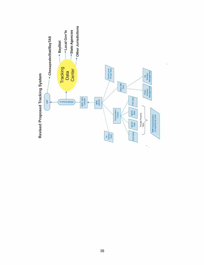
The information captured in the MACS office database identifies “BMPs built”, “how many were installed” and “where they are located”. This information has been through multiple levels of review and approval with multiple people reviewing the information. MACS quantifies BMPs implemented but nutrient reduction benefits that are applied are based on research results approved by the Chesapeake Bay program for utilization in the Chesapeake Bay Model. MDA uses this information to apply figures for nutrient reduction and sediment reduction to BMPs installed with MACS support. MDA is not responsible for quality control related to quantification of nutrient and sediment reduction parameters used by the Chesapeake Bay Program. General Procedure for Collecting, Entering and Reporting BMP Data The SCDs promote and administer the program locally. They assist participants in applying for cost-share and act as liaisons to assure that all information needed by MDA to process an application is provided. The SCD then forwards this information to MDA for review and processing. Within 30 days of receipt of a complete application, MDA will notify the SCD if the application is eligible and indicate total estimated project cost and the amount to be cost-shared by MACS. If the application is incomplete, MDA will contact the SCD to request information or clarification. The data on the application is recorded in Orcale database maintained by the Maryland Department of Agriculture (MDA). Conservation Tracker Maryland’s Conservation Tracker Program is an integrated database management system design to track agricultural conservation implementation in Maryland. This system allows for the accurate assessment of all conservation activity, whether publicly and privately funded, in meeting the Chesapeake Bay TMDL as prescribed in Maryland’s Watershed Implementation Plan. MDA provides information on programs and Best Management Practice implementation to Maryland’s BayStat Program and to the Chesapeake Bay Program Office via the National Environmental Information Exchange Network. Data Collection and Maintenance Conservation data is collected locally by Soil Conservation District (SCD) staff from information maintained in farm-specific Soil Conservation and Water Quality Plans. Once collected, SCD staff are responsible for the timely reporting of this data using a local Conservation Tracker terminal. Data is stored centrally at MDA in an ORACLE RDBMS and is maintained and backed-up nightly per MDA Information Technology Department Standard Operating Procedures. Verification and Quality Assurance Procedures Conservation data obtained using Conservation Tracker will be reviewed and verified for conformation to program requirements and validated using data quality objectives established by MDA Office of Resource Conservation Operations. Only data that are supported by appropriate quality control criteria and meet the data quality objectives will be considered acceptable for reporting. Data validation occurs at the time of entry into the Conservation Tracker System through the extensive use of field validations, including table lookups, formulas, and data-type restrictions. Once processed in the database, MDA generates various quality control
15
charts and reports on a quarterly basis to identify potential data quality issues. Evaluation and verification of any data issue is resolved locally by Soil Conservation District Staff. Soil Conservation and Water Quality Plans Tracking of this is done through conservation tracker. Refer to the section above regarding conservation tracker. Nutrient Management Tracking is accomplished through the Nutrient Management Program of the Office of Resource Conservation, Maryland Department of Agriculture. Data is entered in the data base from paper report forms filed annually by farmers by Maryland Department of Agriculture personnel. The data on the annual implementation report (AIR) is recorded in Orcale database maintained by the Maryland Department of Agriculture (MDA). Paper files are maintained at Maryland Department of Agriculture headquarters and archived after three (3) years. Data listed in the implementation tracking table are defined as the total number of acreage completed for this option during a state fiscal year and is provided on a county basis. Maryland Department of Agriculture regulations require an annual implementation report to document use of current nutrient management plan. The current reporting of nutrient management plan implementation acreage is pulled from this database which is manually entered by Maryland Department of Agriculture staff. Data reported is the total acres reported by farmer multiplied by the annual compliance rate which is based on field inspection. All reporting of data to NEIEN is done by Maryland Department of Agriculture staff which includes Soil Conservation and Water Quality Plans, Nutrient Management, and agricultural bmps.
16 16

BMP Descriptions Approximately 25 different BMPs are eligible for MACS grants. The following is the link to the summary table of BMPs, NRCS codes and accounting units http://www.mda.state.md.us/pdf/macs_manual/2/section_2_table_of_contents.pdf 1) Soil Conservation & Water Quality Plan Implementation – A Soil Conservation and Water Quality Plan (SCWQPI) is a comprehensive plan that addresses natural resource management on agricultural lands and utilizes best management practices that control erosion and sediment loss and manage runoff. SCWQPIs include management practices such as crop rotations and structural practices such as sediment basins and grade stabilization structures. Also included in a SCWQPI are recommendations concerning forestry management, wildlife habitat and plantings, pond construction and management, and other natural resource management recommendations. The practices are designed to control erosion within acceptable levels and to be compatible with management and cropping systems. All NRCS practice codes that are not pulled out separately for tracking of BMP implementation are included in this practice. This tracking is obtained from the 24 Soil Conservation Districts through an information management system administered by the United States Department of Agriculture, Natural Resources Conservation Service and through workload analysis information used by the Maryland Department of Agriculture and the Soil Conservation Districts. The acreage reported in an approved soil conservation and water quality plan (NRCS code 192) is the cropland, pasture, hayland and headquarters on the farm.
17

18
2) Conservation Tillage - This data is compiled by the Chesapeake Bay Program office. It is obtained from biannual reports developed by the Conservation Technology Information Center. Survey data is provided at the county level through the coordination of the USDA Natural Resources Conservation Service who consults with Cooperative Extension, Farm Services Agency, Soil Conservation Districts, as well as local business owners and farmers. Data in this reporting system are organized by county. The Maryland Department of Agriculture is provided a copy of the data for review but is not responsible for its generation or quality control. 3) Retirement of Highly Erodible Land - This option involves the removal of highly erodible land from crop or hay production. The land is planted into either grass or forest and is usually not disturbed for at least 10 years. The Maryland Agricultural Water Quality Cost-Share (MACS) Program data base provides tracking for the implementation of this practice on a tributary basis. The Farm Service Agency, USDA data base provides tracking from the Conservation Reserve Enhancement Program for the implementation of this practice on a county basis. A Microsoft Access file is used to convert this county data obtained from USDA to a tributary level. Data listed in the implementation tracking table are defined as the total number of best management practices completed for the Retirement of Highly Erodible Land during a state/federal fiscal year. The NRCS and FSA practice codes that are used to report this practice are 342, 412, 327, CP1, CP2, CP3, CP3A, CP4D. The MACS data is queried for RHEL practices that are co-cost-shared and total acres of MACS practices are analyzed with FSA acres to avoid double counting. In cases where completed practices are reported in linear feet (NRCS code 412), total acreage is calculated assuming a thirty (30) foot width. This calculation is done by the Maryland Department of Agriculture. 4) Animal Waste Management System Livestock/Poultry - Animal Waste Management Systems are designed for the proper handling, storage, and utilization of wastes generated from animal confinement operations and include a means of collecting, scraping, or washing wastes from confinement areas into appropriate waste storage structures. Lagoons, ponds, or steel or concrete tanks are common structures used for the treatment and/or storage of liquid wastes while storage sheds or pits are used to store solid wastes. Controlling runoff from roofs, feedlots, and "loafing" areas are also part of these systems. Adequate storage ensures wastes are only applied when crops can use the accompanying nutrients and soil and weather conditions are appropriate. The Maryland Agricultural Water Quality Cost-Share (MACS) Program data base provides tracking for the implementation of this practice on a tributary basis. Data is entered in the database from paper files documenting BMPs implemented using MACS program support. A query is then done to extract implementation tracking information from the database. Maryland Department of Agriculture personnel enter this data. The NRCS codes that are used to report this BMP are 313, 359, and 425. The BMP is reported to the CBPO by animal type and animal units. Paper files are maintained at the Maryland Department of Agriculture for three (3) years and archived at the State repository in Jessup. Data listed in the implementation tracking table are defined as the total number of best management practices completed for this option during a state fiscal year. 5) Runoff Control - This practice retrofits existing animal waste storage structures that may not have runoff control. Runoff controls help prevent runoff from upslope areas and roofs to the feedlot or “loafing” area of animals. By controlling this runoff, potential waste nutrients to streams is kept in an area where it can be better managed. Animal
19
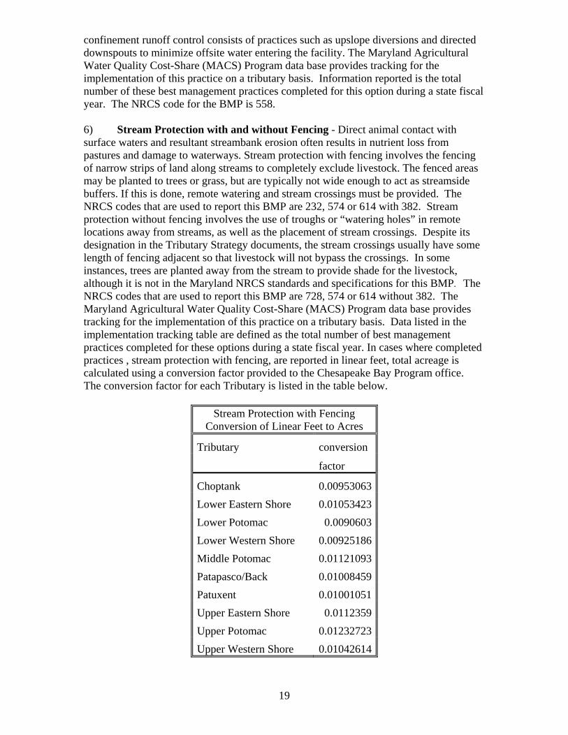
confinement runoff control consists of practices such as upslope diversions and directed downspouts to minimize offsite water entering the facility. The Maryland Agricultural Water Quality Cost-Share (MACS) Program data base provides tracking for the implementation of this practice on a tributary basis. Information reported is the total number of these best management practices completed for this option during a state fiscal year. The NRCS code for the BMP is 558. 6) Stream Protection with and without Fencing - Direct animal contact with surface waters and resultant streambank erosion often results in nutrient loss from pastures and damage to waterways. Stream protection with fencing involves the fencing of narrow strips of land along streams to completely exclude livestock. The fenced areas may be planted to trees or grass, but are typically not wide enough to act as streamside buffers. If this is done, remote watering and stream crossings must be provided. The NRCS codes that are used to report this BMP are 232, 574 or 614 with 382. Stream protection without fencing involves the use of troughs or “watering holes” in remote locations away from streams, as well as the placement of stream crossings. Despite its designation in the Tributary Strategy documents, the stream crossings usually have some length of fencing adjacent so that livestock will not bypass the crossings. In some instances, trees are planted away from the stream to provide shade for the livestock, although it is not in the Maryland NRCS standards and specifications for this BMP. The NRCS codes that are used to report this BMP are 728, 574 or 614 without 382. The Maryland Agricultural Water Quality Cost-Share (MACS) Program data base provides tracking for the implementation of this practice on a tributary basis. Data listed in the implementation tracking table are defined as the total number of best management practices completed for these options during a state fiscal year. In cases where completed practices , stream protection with fencing, are reported in linear feet, total acreage is calculated using a conversion factor provided to the Chesapeake Bay Program office. The conversion factor for each Tributary is listed in the table below.
Stream Protection with Fencing
Conversion of Linear Feet to Acres
Tributary conversion
factor
Choptank 0.00953063
Lower Eastern Shore 0.01053423
Lower Potomac 0.0090603
Lower Western Shore 0.00925186
Middle Potomac 0.01121093
Patapasco/Back 0.01008459
Patuxent 0.01001051
Upper Eastern Shore 0.0112359
Upper Potomac 0.01232723
Upper Western Shore 0.01042614

20
Soil Conservation Districts have provided the Maryland Department of Agriculture with the average size of the pasture and this information is used to convert stream protection without fencing practices to acreage. 7) Nutrient Management – The Water Quality Improvement Act of 1998 requires farmers with gross annual income of $2,500 or more or livestock operations with 8,000 pounds or more of live animal weight to manage their farms using nutrient management plans that protect waterways from excess crop fertilizers and animal waste. Program regulations were finalized in 2001. Farmers meeting eligibility criteria are required to have and implement nitrogen and phosphorus-based nutrient management plans. The legislation mandates MDA to assess proper implementation of the nutrient management plan. All plans are required to be filed with MDA as they are developed. In 2004 legislative changes authorized MDA to require farmers to submit an Annual Implementation Report verifying nutrients applied in the previous calendar year and intent to follow an updated Nutrient Management Plan. MDA is required to maintain a copy of the nutrient management plan for three years in a manner that protects the identity of the individual for whom the plan is prepared. Nutrient Management Plan implementation reviews include determining whether the plans were written in accordance with regulations and whether the plan was properly implemented. Farmers are required to have up to date nutrient management plans and they are required to prepare Nutrient Management Annual Implementation Reports. MDA has 6 inspectors who are located in various regions in separate facilities from the soil conservation offices. This helps segregate the compliance and implementation staff and activities of MDA. The NMP inspection consists of a record review, although the inspector performs a visual inspection of the BMPs related to Nutrient Management Plan implementation on the farm. To determine the accuracy of Nutrient Management Plans a review is done at MDA of plans submitted as part of cost share eligibility. It determines whether the Nutrient Management Plan was prepared in accordance with appropriate requirements and specifications. MDA has been conducting review of plans since 2003. In 2004 the law changed to allow farm operators to retain updated plans on farm since then only plans required for cost share programs have been routinely submitted and reviewed. Plans can be prepared by the farmer if he is MDA certified, a cooperative extension advisor or private consultant. Plans can only be prepared by those that have been certified (farmer or consultant). Field inspections of plans started in 2005. The review process initially included a random selection of farmers to be reviewed but operation types are done proportionately within a geographic region. MDA has targeted 40% of all inspections to operations that produce or utilize manure. In 2007 MDA began targeting inspections in accordance with potential risk or compliance concerns. For the farmer selected, a minimum of three fields are chosen and the farmer’s records of what he grew, and what he said he applied in terms of fertilizer are compared to the nutrient plan. The farmer is required to provide records including, purchases of fertilizer, amount and type of fertilizer applied to the field, and crop yields. After the inspection a four-part nutrient management program plan implementation evaluation report is prepared to document outcomes of the review. Any problems noted during the review requires notation on the evaluation form and a follow-up review. Follow-up inspections are normally done in accordance with a schedule relating to the nature of identified problems.
21
Tracking is accomplished through the Nutrient Management Program of the Office of Resource Conservation, Maryland Department of Agriculture. Data is entered in the data base from paper report forms filed annually by farmers by Maryland Department of Agriculture personnel. Paper files are maintained at Maryland Department of Agriculture headquarters and archived after three (3) years. Data listed in the implementation tracking table are defined as the total number of acreage completed for this option during a state fiscal year and is provided on a county basis. Maryland Department of Agriculture regulations require an annual implementation report to document use of current nutrient management plan. The current reporting of nutrient management plan implementation acreage is pulled from this database which is manually entered by Maryland Department of Agriculture staff. Data reported is the total acres reported by farmer multiplied by the annual compliance rate which is based on field inspection. 8) Cover Crops - The Maryland Agricultural Water Quality Cost-Share (MACS) Program data base provides tracking for the implementation of this practice on a tributary basis. Data listed in the implementation tracking table are defined as the total acreage of cover crops completed for this option during a state fiscal year. Tracking reports only those acres for which a farmer completes his MACS contract. Additional acres may be planted that are not captured because the contract is not completed. 9) Grassed Buffers - Grassed Buffers are linear strips of maintained grass or other non-woody vegetation between the edge of fields and streams, rivers or tidal waters. Grassed buffers help filter nutrients, sediments and other pollutants from runoff, as well as remove nutrients from groundwater. The Maryland Agricultural Water Quality Cost-Share (MACS) Program data base provides tracking for the implementation of this practice on a tributary basis. The Farm Service Agency, USDA data base provides tracking from the Conservation Reserve Enhancement Program for the implementation of this practice on a county basis. A Microsoft Access file is used to convert this county data obtained from USDA to a tributary level. This conversion is done by Maryland Department of Agriculture personnel. Data listed in the implementation tracking table are defined as the total number of best management practices/acres completed for this option during a state/federal fiscal year. The NRCS and FSA practice codes that are used to report this practice are 386, 393, CP21, CP29, CP30. The MACS data is queried for grass buffer practices that are co-cost-shared and total acres of MACS practices are analyzed with FSA acres to avoid double counting. 10) Forest Buffers - Riparian Forest Buffers are linear wooded areas along rivers and streams that help filter nutrients, sediments and other pollutants from runoff as well as remove nutrients from groundwater. In addition to their ability to improved water quality, their value at enhancing terrestrial and aquatic habitat make forest buffers an important BMP for natural resources managers. The Maryland Agricultural Water Quality Cost-Share (MACS) Program data base provides tracking for the implementation of this practice on a tributary basis. The Farm Service Agency, USDA data base provides tracking from the Conservation Reserve Enhancement Program for the implementation of this practice on a county basis. A Microsoft Access file is used to convert this county data obtained from USDA to a tributary level. Maryland Department of Agriculture personnel perform this calculation. Data listed in the implementation tracking table are defined as the total number of best management practices/acres completed for this option during a state/federal fiscal year. The NRCS and FSA practice codes that are used to report this practice are 391, 650, CP22. The MACS data is queried for grass buffer

22
practices that are co-cost-shared and total acres of MACS practices are analyzed with FSA acres to avoid double counting. DNR has provided no coordination with MDA on what they report for this practice on agricultural land. 11) Wetland Restoration - "Wetland restoration" refers to the reestablishment of wetlands on sites where they used to exist. The Tributary Strategy goal involves more than just restoration. It also includes wetland creation and enhancement. Wetland creation projects establish wetlands on upland sites. These projects establish new wetlands, where wetlands did not previously exist. In order to create new wetlands, a site usually requires lowering the elevation of the land by grading the soil. This increases the frequency of soil saturation, flooding, and ponding. Wetland enhancement projects provide additional protection to, or improve the functions of, existing wetlands. Stream restoration projects, such as stabilizing the banks or restoring the natural meander pattern to a channelized stream, are also examples of projects that can enhance existing wetlands. The Maryland Agricultural Water Quality Cost-Share (MACS) Program data base provides tracking for the implementation of this practice on a tributary basis. The Farm Service Agency, USDA data base provides tracking from the Conservation Reserve Enhancement Program for the implementation of this practice on a county basis. A Microsoft Access file is used to convert this county data obtained from USDA to a tributary level. Maryland Department of Agriculture personnel perform this calculation. Data listed in the implementation tracking table are defined as the total number of best management practices/acres completed for this option during a state/federal fiscal year. The FSA practice codes that are used to report this practice are CP23, CP9. The MACS program does not cost-share this practice currently so there is no possibility of double counting. MDE who provide data to the CBPO’s Wetland Evaluation Taskgroup database has provided no coordination with MDA on what they report for this practice on agricultural land. 12) Manure Transport - The Manure Transport Program provides grants to help poultry, dairy, and other animal producers transport excess manure off their farms or avoid application on phosphorus enrich cropland. Animal producers with high soil phosphorus levels or inadequate land to utilize their manure in accordance with the nutrient management plan can receive cost-share assistance of up to $20 per ton to transport excess manure to other farms or alternative use facilities that can use the product in an environmentally sound manner. The Maryland Agricultural Water Quality Cost-Share (MACS) Program data base provides tracking for the relocation of manure. The final tracking of manure transported from a Maryland farm to another farm or alternative use is documented by using a Chain-of-Custody form which tracks individual truck loads. A Microsoft Access file is used to collate the Chain-of-Custody form data to tally tons of manure transported by the sending county and respective receiving county or state. MDA provides to the CBPO tons of manure transported by animal type, poultry or other manure (dairy, poultry layer, turkey) for implementation reporting. Manure transported under the Manure Transport Project is transported by weight (tons) or by volume (cubic yards, gallons). Transporting greater that 25 miles requires a weight ticket after weighing the transporting vehicle (gross and tare weights) at a certified scale. Transporting by volume (cubic yards, gallons) requires size or capacity of the vehicle to be documented. Manure Transport Project Conversion Factors
1. 8.3 pounds / gallon manure
23
2. 1,000 gallons / 4.15 tons Conversion used to report tons to CBPO, mostly liquid dairy manure.
3. 7.5 gallons / cubic foot 4. 60 pounds / cubic foot 5. 1.25 cubic feet / bushel
mass of nutrients Manure transported under the Project are required to be analyzed prior to transporting. For land application, the manure analysis from the sending operation is used to determine the amount/rate of manure that can be applied to receiving fields. Alternative uses are not required to analyze manure. An average analysis for poultry litter may be used to develop interim nutrient management plan. (101) 13) Precision Agriculture - Providers of agronomics services (such as fertilizer retailers or independent crop consultants) compile and document data that verifies acres of implemented precision agriculture practices. This tracking data is provided to the Maryland Department of Agriculture on a county basis. The Maryland Department of Agriculture compiles this data and provides it annually to the Maryland Department of Environment.
24
State Agency Roles and Responsibilities with regard to the National Environmental Information Exchange Network The National Environmental Information Exchange Network (NEIEN) is a partnership between the Bay jurisdictions and the CBPO for the secure, real time exchange of BMP implementation information. The Network uses extensible markup language (XML), web services for geo-location, and common data standards to transmit data from the jurisdictions to the CBPO. Existing data management systems are able to remain in place and through the Network, data is transferred based on strict formatting methods, or a schema The schema in use contains fields such as jurisdiction, data source, contact information, name of practice, practice components, unique ID for practices, location, unit of measure, quantity, status, and funding source. BMP data are submitted on an annual or more frequent basis from MDA to MDE as part of a program to disseminate this data from agriculture-related sectors. The data are sent via electronic mail in MS Excel spreadsheets to MDE’s Science Services Administration (SSA). SSA converts the data into a single database with a consistent format that conforms to the rigors demanded by the NEIEN, which began accepting data in 2010. Once SSA receives the BMP data from MDA, it will conduct several formatting tests to make sure the information provided is consistent with previous NEIEN submission formats to assure successful conversion into an XML document, and acceptance by the CBPO node. MDE-SSA personnel test submissions received by MDA immediately after receipt. If there are non-conforming data, SSA reports results back to MDA for further modification until the deadline for submission is met. The NEIEN submission will be verified by CBPO, through Tetratech, by sending out a summary of acceptance of the individual BMP types when processed by its Scenario Builder tool. MDA will then have the opportunity to review and update the submission prior to finalizing the annual submission. The exchange data provided contains projects that were implemented between July 1 and June 30 of each calendar year, corresponding to the State fiscal year. The deadline for submission of this information is December 31, 2011. This was met by MDA through it’s submission on December 2, 2011 and through MDE’s submission through the CBPO node on December 21, 2011 as node document ID# “_49de29d2-b3e8-4185-a12f-acfd11cd97b0”.