mark malinowski - dtsc · mark malinowski may 2, 2017 page 2 of 53 • data historically collected...
TRANSCRIPT

Mark Malinowski May 2, 2017 Page 2 of 53
• Data historically collected at Brandeis Bardin during the Multi-Media Study conducted in 1992 and 1994 under the oversight of the United States Environmental Protection Agency (US EPA),
• Environmental and Radiological Data Summary and Health Risk Evaluation for the AJU Brandeis-Bardin Campus at Simi Valley, California. This investigation was conducted in 2016 by Tetra Tech, Inc. for AJU,
• United States Department of Energy’s (DOE) chemical investigation conducted per the 2010 Administrative Order on Consent, and
• Data historically collected at Brandeis Bardin collected by Brandeis Bardin’s consultant, Joel Cehn.
Geographic Information Systems (GIS) were utilized to evaluate data from the above investigations as well as additional published and unpublished data from previous RFI efforts. GIS was also used to review data distribution from on-site contaminant source areas, through the Northern Buffer Zone, and (where present) off-site at Brandeis Bardin.
The conclusions and recommendations made in this white paper are intended to assess if environmental data are indicative of a complete contaminant migration pathway, and based on screening of the data, communicate the presence (or lack of) potential human health threats at the Brandeis property. GSB conducted the evaluation and conferred with other DTSC technical staff (hydrogeologists, toxicologists and engineers) during preparation of this document. DTSC will continue to support and implement the respective 2010 Administrative Orders on Consent with the US Department of Energy (DOE) and NASA, and the 2007 Consent Order with Boeing for the SSFL cleanup.
INTRODUCTION
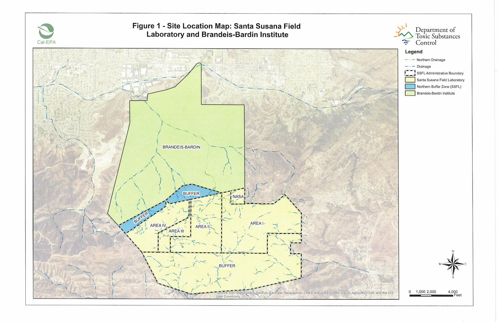
Brandeis Bardin, located in the Simi Hills of Ventura County, California (Figure 1), is an educational center that is also used for camping and hiking. SSFL is located on 2,850 acres in the hills above and directly south of Brandeis Bardin. SSFL activities included rocket engine testing starting in the late 1940s, and nuclear energy research and supporting operations starting in the 1950’s. Most nuclear research-related programs and operations ceased in 1988 (http://www.etec.energy.gov/Operations/Operations_History.html). Rocket engine testing declined in the 1980s and 1990s, and ended in 2005. SSFL comprises four administrative areas (Areas I, II,

Mark Malinowski May 2, 2017 Page 3 of 53 III, and IV) with undeveloped land to the north and south. Area IV is located along the western portion of SSFL, and is where DOE and its predecessor agencies were engaged in or sponsored nuclear research operations and associated experiments.
Previous SSFL operations and activities resulted in the release of chemicals and radionuclides to the environment. Many environmental investigations have been conducted throughout SSFL to assess the nature and extent of contamination associated with former operations and activities at SSFL, as well as the potential contaminant migration pathways for various media (e.g., soil, surface water, groundwater, air).
Under US EPA oversight, a Multi-Media Study was initially conducted in 1992, with follow up sampling conducted in 1994. The US EPA and various other regulatory agencies reviewed and approved the initial work plan, provided recommendations for the follow up sampling, and conducted independent sampling. The soil results identified radiological concentrations (greater than local background levels established at that time) north of and adjacent to Area IV, on what was then Brandeis Bardin property, in drainages associated with two on-site operational areas in Area IV (Building 59 and Radioactive Materials Handling Facility).
In 1995, the US EPA issued a fact sheet (US EPA, 1995) and stated that while the radionuclide impacts exceeded local background levels established at the time, they did not pose a threat to human health or the environment.
The second round of sampling conducted in 1994 for the Multi-Media Study confirmed removal of mercury identified in the former sodium disposal facility watershed area during the initial round of sampling conducted in 1992. The land encompassing these watershed areas was included within a larger strip of land subsequently acquired in 1997 by the Rocketdyne Division of Boeing North American. That strip of land is now referred to as the Northern Buffer Zone. The Northern Buffer Zone is an undeveloped area where no SSFL operations were located, and separates the current Brandeis Bardin property from former operational areas of SSFL.
Interim measure cleanups have been conducted at SSFL to remove contaminated soils that might potentially migrate via surface water to the Brandeis Bardin property below (Figure 2). Recent interim measure activities include:

Mark Malinowski May 2, 2017 Page 4 of 53
• Cleanup of the Former Sodium Disposal Facility (FSDF) in 2000 (See Figure 2 and Draft Interim Measure Implementation Report, FSDF, Shaw Environmental & Infrastructure, Inc., September 2002 [Shaw, 2002]),
• Cleanup of the Northern Drainage between 2008 and 2010, and • Implementation of an interim source removal action between 2009 and 2013
(See Figure 2 and Northern Drainage Clay Target Debris Removal Action Report, Haley & Aldrich, Inc., December 2010 [Haley & Aldrich, 2010]).
Significant amounts of newer analytical data have been generated by the completion of two large-scale environmental investigations in Area IV and the Northern Buffer Zone at SSFL: the US EPA’s radiological characterization, and the United States Department of Energy’s (DOE) chemical characterization. An additional investigation for chemicals and radionuclides was completed in 2016 by AJU at the Brandeis Bardin Campus (2016 Brandeis Bardin Study).
Prior to these investigations, exposure assessments were conducted to evaluate data from existing studies in order to determine if there were health effects to the communities surrounding SSFL (Agency for Toxic Substances Disease Registry, 1999; University of California Los Angeles, 2006; and SSFL Panel Advisory Reports, 2006). These studies relied on environmental data available at the time, and did not have the radiological and chemical data now available from these investigations. The extensive data obtained from the recent investigations can be used to better understand the nature and extent of radionuclides and chemicals at Area IV and their SSFL source areas, as well as for evaluating the completeness (or lack thereof) of current potential exposure pathways.
US EPA’s Radiological Characterization of Soils at SSFL’s Area IV and Northern Buffer Zone
In 2011, to support the radiological characterization study, the US EPA completed an extensive off-site radiological soil background study that provided updated local soil background threshold values. The results were published in a Radiological Background Study Report (HGL, 2011).
In 2012, the US EPA completed a comprehensive radiological characterization study of SSFL at Area IV and the Northern Buffer Zone (collectively referred to as the Area IV Study Area). Soil, groundwater, surface water and sediment samples were collected

Mark Malinowski May 2, 2017 Page 5 of 53 and analyzed. The primary objective was to evaluate the nature of potential radiological contamination in soil and drainage sediment that may have resulted from past nuclear operations and research activities in the Area IV Study Area. US EPA’s Area IV radiological study included the collection of a total of 3,487 soil samples and 55 sediment samples. In Round 1, a total of 2,781 soil and/or sediment samples were collected and analyzed for a comprehensive suite of radionuclides. In Round 2 a total of 761 samples were collected to further define the background and/or detection limit exceedances identified during Round 1 (HGL, 2012a).
Summary of DTSC’s Conclusions based on US EPA’s 2012 Area IV Study Findings
• The key radionuclides of concern are Cs-137 and Sr-90. • The extent of impacts from releases at SSFL source areas have been delineated
within the SSFL boundary for the air dispersion pathway. • While there are localized areas of detected Sr-90 in the SSFL Northern Buffer
Zone, the data indicate that Radiological Areas of Interest did not migrate off site. • The Northern Buffer Zone results showed no pattern or grouping of exceedances
that indicate off-site migration of contamination that would pose a threat to students, faculty, staff or visitors to Brandeis Bardin.
Derivation of Field Action Levels: US EPA screened soil and drainage sediment sample results to Field Action Levels (FALs) to identify potential Radiological Areas of Interest. FALs were derived from US EPA’s 2011 Radiological Background Study’s Background Threshold Values. For radionuclides with Background Threshold Values that were too low to routinely and reliably detect, the FAL was derived using the Area IV Radiological Study’s achieved method minimum detectable concentrations (MDC). The greater of the Background Threshold Value or the 2 sigma Upper Confidence Limit MDC was selected as the FAL for each laboratory for each radionuclide.
Background Threshold Values represent the upper limit of radioactivity expected in an uncontaminated background sample. These were calculated using the background study dataset, and were based on the 95% Upper Simultaneous Limit (USL95). The USL95 represents the maximum concentration at and below which 100% of all future comparisons must fall, with a 95 percent confidence level (Singh 2011).

Mark Malinowski May 2, 2017 Page 6 of 53 Rather than comparing each sample’s result to its own sample-specific MDC, US EPA utilized laboratory-specific method MDCs, which were derived for each radionuclide using the 2 sigma Upper Confidence Limit (UCL) MDC for each radionuclide’s respective dataset (HGL, 2012a). The “2 sigma” confidence interval conveys the precision of the mean MDC of the Area IV Study’s sampled population. An analytical result represents an estimate of the mean concentration of the many individual particles that make up the analytical subsample. Environmental remediation decisions are often made based on the estimate of the mean concentration of contaminants within an identified volume of media (ITRC, 2012). The central limit theorem states that the sampling distribution of the sample mean approximates the normal distribution, regardless of the distribution of the population from which the samples are drawn if the sample size is sufficiently large (Boslaugh, 2013 and Helsel and Hirsch, 2002). The “2 sigma” UCL MDC is a 95 percent confidence interval on the Area IV Study’s mean MDC. The “2 sigma” is traditionally approximated to “2” standard deviations, but a 95 percent confidence interval actually has a Z value of 1.96 standard deviations about the mean, based on the standard normal distribution (Z distribution). The complement of 95 percent confidence is a 5 percent Type I error, which is split on both ends of the interval, with a one-sided upper confidence limit on a “2 sigma” MDC having 97.7 percent confidence level, or if rounded, a 2.5 percent Type I error. The 2 sigma UCL MDC is thus used as a one-sided 97.7 percent upper confidence limit on the mean, which is referred to by US EPA as the “97.7 percent confidence level of the standard normal cumulative probability”. The SSFL 2 sigma UCL MDCs were calculated from 3,772 sample results, which represent all soil matrix sample results for the Area IV Study. For each radionuclide and each laboratory, the mean MDC and the standard deviation of the mean MDC were calculated. The mean was summed with twice the standard deviation (or sigma) to determine the UCL for the respective MDC dataset. This expression of analytical uncertainty is similar in concept to the sample-specific approach for reporting analytical results of measurements and associated uncertainty, where uncertainty is expressed in the form of a combined standard uncertainty (similar to standard deviation) multiplied by a coverage factor (similar to number of standard deviations, based on specified level of confidence) to produce an expanded uncertainty with a specified level of confidence (e.g., an uncertainty interval). An expanded uncertainty calculated with a coverage factor of 2 would have a coverage probability of 95%, and may be informally referred to as a “two-sigma” uncertainty. Additional information regarding radiological data and

Mark Malinowski May 2, 2017 Page 7 of 53 reporting measurement uncertainty is provided in the Multi-Agency Radiological Laboratory Analytical Protocols (MARLAP) Manual (EPA 2004), specifically, see chapter 19. Use of Field Action Levels for Determining Radiological Areas of Interest: This analysis provides a first cut at identifying key radionuclides of concern and radiological areas of interest that merit further evaluation, and those that do not. US EPA used sample locations with results greater than or equal to FALs to identify potential Radiological Areas of Interest. US EPA’s comparison of the two laboratories’ Area IV study results against the FALs is relevant for tentatively evaluating the extent of radiological impacts until the Look-up Table is finalized, as comparison of results may be made to the background threshold value (e.g., for Cesium-137) or laboratory-specific achieved method MDC value (e.g., 2 sigma UCL MDC for Strontium-90).
A sample that exceeds a FAL or its respective MDC (based on the 2-sigma UCL), does not necessarily mean the sample represents contaminated soil. Comparison of analytical results to FALs does not require a decision level-type of assumption that the result’s analytical uncertainty is tightly constrained at a specified decision error rate at that action level. Thus, FALs are not decision levels, and the results of the FAL comparisons do not conclusively represent or confirm locations or areas of contamination ((HGL, 2012a). Similarly, comparison of analytical results to their respective 2 sigma UCL MDCs should not be considered as detection decision criterion (HGL, 2012b).
Of the 55 radionuclides analyzed, 28 were detected above the FALs. Of these, 17 were identified by US EPA as Naturally Occurring Radiological Materials. The remaining 11 radionuclides, which exceeded the FALs, were attributed to SSFL radiological operations, and thus were referred to as site-related radionuclides.
Radionuclides of Concern: US EPA’s findings indicate that the key radionuclides of concern are Cs-137 and Sr-90. Cs-137 had the greatest frequency of FAL exceedances (291 exceedances at <10 percent of total samples collected), followed by Sr-90 (153 exceedances at <5 percent) and Pu-239/240 (14 exceedances at <0.05 percent). The remaining eight radionuclides of concern had five or fewer FAL exceedances.

Mark Malinowski May 2, 2017 Page 8 of 53 The few FAL exceedances, and therefore few locations of exceedances for Pu-239/240 and the remaining radionuclides of interest, were observed in the Area IV Study Area. On-site findings show Cs-137 and Sr-90 to be the key radionuclides of concern.
Radiological Areas of Interest Locations: EPA’s on-site study showed that most of the FAL exceedances occurred near former Area IV operational areas. The significant volume of sample data, and the density and coverage of sample locations throughout Area IV and the Northern Buffer Zone allow a comprehensive evaluation of air and surface water migration of contaminants from release areas in Area IV. For example, contaminants dispersed via air from burn activities would have deposited near the source area on soil, nearby land surfaces, and along drainages.
More insight on the air dispersion pathway can be gained by evaluating findings from air dispersion studies conducted within SSFL at locations outside of Area IV. DTSC-approved air dispersion evaluations have been conducted at SSFL to understand where pollutants from on-site combustion sources were likely deposited onto the ground. Soil chemical sampling results supported the air dispersion modelling results, which indicated that impacts from various on-site sources of air emissions do not fall far from source locations and decrease with distance from source locations (CH2M Hill, 2014).
These on-site studies modeled six SSFL representative air emission sources. The findings indicate that most of the modeled cumulative particle deposition occurs within 0.5 kilometers (1,640 feet) from the source locations and is generally confined to the boundaries of the RFI sites. In all modeled cases, the cumulative particle deposition impacts fell within the SSFL boundary. In addition to modelling efforts, significant sampling efforts have been conducted at SSFL at locations within, in proximity to, and outside of RFI site source areas, including downwind locations. Inclusion of this data is an important part of the evaluation of the air dispersion pathway. Based on evaluation of US EPA’s data from their on-site study, the extent of impacts from releases at source areas have been delineated within the SSFL boundary for the air dispersion pathway. The off-site data from the 1992-1994 Multi-Media and 2016 Brandeis Bardin Studies are consistent with this finding.
US EPA found that approximately 70 percent of soil samples with radionuclide concentrations greater than the Field Action Levels were located within five Radiological Areas of Interest (see Figure 2):
Mark Malinowski May 2, 2017 Page 9 of 53
• Radioactive Materials Handling Facility complex; • Former Sodium Reactor Experiment complex; • 17th Street Drainage; • Former Fuel Element Storage Facility; and • New Conservation Yard Drainage Area.
These findings are consistent with the knowledge that these locations are also chemically contaminated, as at least some portion of these areas had been designated by DOE as a “Likely Chemical Remediation Zone.” The remaining Area IV Radiological Areas of Interest have fewer and generally lower concentrations of the radionuclide(s) of concern associated with the former building or historical operation.
Plutonium Findings: Data from the US EPA’s study and the 1994 Multi-Media Study indicate that there is not a complete contaminant migration pathway of Pu-238 and Pu-239/240 from Area IV through the Northern Buffer Zone to Brandeis Bardin. The 1992 Multi-Media Study at Brandeis Bardin identified two plutonium-238 detects above the background in two watersheds near the Area IV boundary in what is now the Northern Buffer Zone. The 1994 follow-on Multi-Media Study resampled these areas, and Pu-238 and Pu-239 had activities reported as less than the detection limits in all samples collected.
US EPA’s study did not identify Pu-238 FAL exceedances in the Northern Buffer Zone. A single Pu-239/240 FAL exceedance was identified in the SSFL Northern Buffer Zone in surface soil located near the Area IV boundary, but no other Pu-239/240 Field Action Level exceedances were identified in the Northern Buffer Zone. Soils in the Northern Buffer Zone will be subject to cleanup levels consistent with SSFL look-up table values, as required under the Administrative Order on Consent.
Incomplete Radiological Contaminant Exposure Pathway Means No Evidence of Off-Site Exposure to SSFL Radiological Contaminants: US EPA’s data indicate that contaminants related to the Radiological Areas of Interest did not migrate off site. Most of the Radiological Areas of Interest in the Northern Buffer Zone are for Sr-90. Where the limited number of Sr-90 FAL exceedances in the Northern Buffer Zone drainages occurred, samples were collected downstream. These sample values were below the FAL.

Mark Malinowski May 2, 2017 Page 10 of 53 Three other radionuclides had a limited number of FAL exceedances at isolated locations in the Northern Buffer Zone:
• Cs-137 (four exceedances: two in eastern Northern Buffer Zone, one near Area IV boundary, and one northwest of Former Sodium Disposal Facility),
• Plutonium-239/240 (one exceedance near the Area IV boundary), and • Curium 243/244 (one exceedance near the Area IV boundary).
The Northern Buffer Zone results showed no pattern or grouping of exceedances that indicate off-site migration of contamination that would pose a threat to students, faculty, staff or visitors to Brandeis Bardin. Since no Radiological Areas of Interest were identified as extending off site, the exposure pathway is incomplete, and people at Brandeis Bardin are not expected to be at risk from exposure to radionuclides from Area IV.
Analytical Method Uncertainty Considerations: A measurement conceptually consists of two parts: the “true score” (hypothetical true concentration of the analyte) plus the error (hypothetical concentration due to uncertainties; Boslaugh, 2013). Uncertainties can be managed and constrained to meet program requirements, but can never be fully eliminated. Contributions of uncertainty can come from sampling efforts and soil heterogeneities, plus analytical uncertainty. Sampling uncertainties are managed through implementation of field sampling plans that include standard operating procedures as well as a strong quality assurance/quality control program. EPA evaluated sample heterogeneity (variability of radionuclides concentrations in the field over a small area) through site-wide analysis of field duplicate samples from the Area IV Study (195 field duplicate pairs), and determined that the degree of heterogeneity was slightly higher than the 10 percent initially assumed during development of field duplicate acceptance criteria (Section 4.1, HGL, 2012a).
Analytical uncertainties are managed by establishing analytical sensitivity performance criteria for individual data points by setting acceptable error rates for Type I errors (false positives) and Type II errors (false negatives). Section 2.2.6 of EPA’s Quality Assurance Project Plan (QAPP) for Soil Sampling (HGL, 2012c) describes the steps that analytical laboratories are to take to control these analytical errors. The QAPP describes Measurement Quality Objectives (MQOs) that control the Type I and Type II decision errors at 5 percent each, and establishes a required relative method uncertainty for each target radionuclide at no more than 10 percent when the measured activity is at or above the action level. The action level is thus the activity at which the relative method
Mark Malinowski May 2, 2017 Page 11 of 53 uncertainty for a radionuclide is equal to 10 percent. When sample activity for an isotope is less than the action level, the absolute method uncertainty is not to exceed 10 percent of the action level. Setting the relative and absolute method uncertainties allows the probability of decision errors to be maintained at the 5 percent rate. The laboratory action levels presented in Table 2.1 of Addendums 1 and 2 of the QAPP represent the US EPA-approved laboratory-specific action levels for both laboratories, at which the requirements for constraining the relative and absolute method uncertainties can be practically achieved. This approach is consistent with the approach described in the MARLAP Manual (USEPA, 2004). EPA’s approach represents a balance for constraining the two types of analytical decision errors. A false positive error results when identifying contamination where it actually does not exist. Lack of control of false positives can impact the decision-making ability to conclude cleanup is complete, thus impacting the overall implementability of a project. A false negative error results when failing to identify contamination where it actually does exist, and if uncontrolled, can impact the overall project’s objective of identifying contamination. While much of this paper focuses on the subject of false positives, throughout this project, great weight was given to constraining false negatives. False negatives are addressed at the analytical scale, as described in the QAPP, and are ultimately addressed through the significant size of investigation’s sampling efforts. A discussion of the presence of false positives should not be construed as minimizing the importance of controlling false negatives. Just as a high level of confidence can be used to manage the rate of false positives, a high level of statistical power can be used to manage the incidence of false positives. Since power increases as the number of samples increases, and given the large number of samples collected throughout the Area IV Study, DTSC has much power when concluding there are areas where contamination likely does not exist. There are sample locations within the Northern Buffer Zone that have Sr-90 FAL exceedances, but these FAL exceedances are not necessarily indicative of contamination. During and after completion of the Area IV Study, EPA acknowledged that achieving measurement quality objectives for Sr-90 analysis is technically challenging (HGL, 2012). While EPA’s two laboratories were able to generate data that were of acceptable quality for the Area IV study’s intended use (characterization of radionuclides), the data did not have analytical uncertainty constrained at the level that was initially desired. The individual sample Sr-90 FAL exceedances had results reported below the analytical equipment’s reliable detection capability (specified in the QAPP as the laboratory action level), and increased analytical uncertainty is likely

Mark Malinowski May 2, 2017 Page 12 of 53 present at these low levels. Use of analytical instruments to find very low levels of chemicals or radionuclides, particularly for a large project with significant programmatic needs, can involve an increase in analytical uncertainty and when making multiple point-by-point comparisons, which can result in an increase in false positives. Both of EPA’s Area IV Study laboratories’ demonstrated Sr-90 analytical method uncertainty associated with the respective Radiologic Reference Concentration (RRC) and 2 sigma UCL MDC (see Attachment B of Appendix K in HGL, 2012a) were higher than initially desired. The majority of the Sr-90 exceedances in the Northern Buffer Zone were based on results from the laboratory associated with the highest rate of uncertainty (100 percent at its 2 sigma UCL MDC). A lower tolerance for analytical uncertainty is needed when making decisions regarding the presence of contamination and confirmation of the removal of contamination. The investigation achieved relatively low MDCs, which may be desired when looking for detected concentrations during characterization, but in doing so, sacrificed the desired level of constraint of uncertainty which can result in elevated decision error and an increased incidence of false positives. In other words, while the FAL exceedances represent results that may be detected, we cannot accept that the data were adequately quantified at a level that we can compare to a regulatory threshold and make a decision of exceedance. We have less tolerance for analytical uncertainty when making such decisions. If these exceedances were attributed to elevated analytical method uncertainty (which is random), then we would expect the presence of exceedances due to false positives to also be random. In the Northern Buffer Zone, this is the case, as the Sr-90 FAL exceedances follow no grouping or pattern. All of the Sr-90 FAL exceedances in the Northern Buffer Zone have reported results that are less than their respective laboratory action level, and should be viewed with caution. While it is important to have a sufficient quantity of data to estimate the mean contaminant concentration in soil within a specified volume for purposes of making decisions regarding the need for or the confirmation of cleanup efforts, it should also be noted that the 2 sigma UCL MDC value used for point-by-point comparisons to the FAL represents a “collective measure” of central tendency, and in its ProUCL Version 5.0.00 User Guide, EPA cautioned against conducting individual sample result comparisons with a UCL-based value (page 42, USEPA, 2013), due to increased false positives resulting from many point by point comparisons. DTSC expressed this concern as well (DTSC, 2013b). Point-by-point comparisons to upper threshold values such as the USL95 are appropriate, as they more efficiently control the error rate. Based on this reasoning, an increase in the number of point-by-point comparisons to the 2 sigma UCL

Mark Malinowski May 2, 2017 Page 13 of 53 MDC (such as for Sr-90) can result in an increasing number of false positives to an unacceptable level. Based on this and other lines of evidence, the US EPA results do not indicate contaminant migration off-site from the NBZ.
It should be noted that even with a limited level of tolerance for uncertainty; there is an unavoidable chance that a small percentage of comparisons to background will result in a decision that the sample result exceeds background when in fact it does not. Analytical uncertainty cannot be completely eliminated, nor can the possibility of encountering false positives be eliminated. In light of this, options are available that can involve resampling or keeping the initial result and addressing it directly. To be protective, the potential false positive can be compared to a risk-based screening level in order to evaluate whether it warrants additional attention.
Risk-based screening levels (RBSLs) can be useful for simple comparison, but they were not originally intended for use with point-by-point comparisons. RBSLs are not cleanup standards and should not be applied as such. They can be used to help identify areas, contaminants, and conditions, which may require further attention; however, just because a sample exceeds a risk based screening level does not automatically designate a site as contaminated. More information on the use of risk-based screening levels can be found at EPA’s PRG Frequently Asked Questions, and Soil Screening Guidance for Radionuclides: User’s Guide, and Regional Screening Levels Frequent Questions (May 2016).
Off-Site Brandeis Bardin Studies
Summary of 1992 and 1994 Multi-Media Studies
• Soil results identified radiological concentrations (greater than local background levels established at that time) north of and adjacent to Area IV, on what was then Brandeis Bardin property, in drainages associated with two on-site operational areas in Area IV (Building 59 and Radioactive Materials Handling Facility).
• The 1994 study confirmed removal of mercury identified in the former sodium disposal facility watershed area during the initial round of sampling conducted in 1992. The land encompassing these watershed areas was included within a larger strip of land subsequently acquired in 1997 by the Rocketdyne Division of

Mark Malinowski May 2, 2017 Page 14 of 53
Boeing North American. That strip of land is now referred to as the Northern Buffer Zone, is an undeveloped area where no SSFL operations were located, and separates the current Brandeis Bardin property from former operational areas of SSFL.
• In 1995, the US EPA issued a fact sheet (US EPA, 1995) and stated that while radionuclide impacts exceeded local background levels established at the time, they did not pose a threat to human health or the environment.
In addition to US EPA’s recent SSFL findings, DTSC also reviewed chemical and radiological data collected at the Brandeis Bardin property during the 1992 (McLaren/Hart, 1993) and 1994 (McLaren Hart, 1995) Multi-Media Studies and the recent 2016 (Tetra Tech, 2016) Brandeis Bardin sampling report.
The US EPA oversaw the 1992 and 1994 Multi-Media studies, which were conducted to determine if chemicals or radionuclides had migrated or been deposited on properties adjacent to SSFL. The 1992 study included the selection and sampling of Background Areas to establish a background data set for comparison of data collected from the Brandeis Bardin property. The goal was to distinguish naturally occurring concentrations of heavy metals and radionuclides from concentrations that may have originated from SSFL or other human activities.
The 1992 Multi-Media sampling focused on fourteen human activity areas and five ravines (watersheds) at Brandeis Bardin. A total of 118 soil/sediment samples were collected during the 1992 sampling efforts. These samples were analyzed for chemicals and radionuclides (including Cs-137 and Sr-90). The 1992 Multi-Media Study used a sampling approach that involved statistical and non-statistical comparisons of sample results to background values. The background dataset was derived from data collected from six designated background areas. The statistical sampling approach utilized random samples collected from “human activity areas” (with each area representing a population) on the Brandeis Bardin property. The initial statistical test compared the means of each sample population with the background population. To account for variance between and within the background sample areas, the statistical test was also rerun using the standard error of the mean for the background area (two standard deviations above the mean background concentration, referred to as the 95th percentile). The statistical test findings concluded that the sampled areas at Brandeis property were not statistically different from background.
Mark Malinowski May 2, 2017 Page 15 of 53 Drainages were considered as linear features, and sample locations were treated as deterministic (or biased), and not random. These data were compared on a point by point basis with the background-based value established at the time. Results of the point-by-point comparison identified some exceedances of radionuclides in sediment samples above the 95th percentile of the measured background. These exceedances were located within what is now the Northern Buffer Zone. Statistical comparison of the means of these sediment data from the ravines to background (via t-tests) showed that they were not significantly different. Based on these findings, the report stated that it could not be definitively concluded whether the sediment sample exceedances represented off-site migration from SSFL because, when the statistical test was run, there was no difference from background (McLaren/Hart, 1993). In the follow-on 1994 Multi-Media Study, additional soil/sediment and background samples were collected (McLaren Hart, 1995). The 1992 and 1994 soil/sediment sampling results were then statistically compared to an expanded background data set to determine if values in the Study Areas were the same as background, and no statistically significant difference between sampled areas at Brandeis Bardin and background was identified.
An entire stretch of Meier Canyon drainage has been sampled from SSFL to the BBI campus, with the exception of a very steep relatively inaccessible (approximately 1,200-foot) stretch of drainage located between Campsite 1 and the campus below. The majority of the Multi-Media Study locations having single point exceedances above background for Cs-137 and/or Sr-90 have been subsequently resampled, and have been found to be within the range of local background. Based on this, the statistical findings from the Multi-Media Study are supported by the subsequent sampling efforts, primarily by EPA at Area IV and Tetra Tech at BBI. Single point Cs-137 exceedances of the background established at the time occurred in the Building 59 Watershed (BB-17), at locations that are now within the Northern Buffer Zone (see Figure 27 (McLaren Hart, 1995)). EPA’s Area IV Study resampled within and around this watershed, and identified no FAL exceedances for Cs-137 (see Figures 4.1 and 4.2 HGL, 2012a). Single point exceedances of Cs-137 and Sr-90 were identified in 1992 in the SRE Watershed (see Figure 29 (McLaren Hart, 1995)), but when resampled in 1994, the Cs-137 results were detected (and confirmed) at much lower values that were less than background. EPA’s Area IV Study identified no FAL exceedances for Cs-137 or Sr-90 in the SRE Watershed within the Northern Buffer Zone. Single point exceedances of Cs-137 and Sr-90 were identified in the RMDF Watershed (see Figure 26 (McLaren Hart, 1995). Although numerous Cs-137 and Sr-90 FAL exceedances were identified near the RMDF Watershed within Area IV (and will be addressed as required under the AOC), no Cs-137 FAL exceedances were identified in this watershed within the Northern Buffer Zone.

Mark Malinowski May 2, 2017 Page 16 of 53 This area had two Sr-90 FAL exceedances identified in the Northern Buffer Zone near the Area IV boundary, but additional samples collected down drainage in the Northern Buffer Zone showed no additional FAL exceedances. One single point exceedance for Cs-137 was found in 1992 within the human activity areas on BBI (BB-05). This area was subsequently resampled in 2016 by Tetra Tech, and no Cs-137 background exceedances were identified. A single point exceedance for Cs-137 was identified in 1992 at the Old Well Campsite. This area was identified during the Tetra Tech Study as being located near the background eastern drainage. (Figure 9, Tetra Tech, 2016). Single point exceedances of Cs-137 and Sr-90 (not co-located) were identified in 1992 at Campsite 1, and a single point exceedance of Sr-90 was identified in the Campsite 1 Drainage during the 1994 sampling. Campsite 1 and drainage was initially sampled in 1991 by Joel Cehn, the consultant for Brandeis Bardin, and found Cs-137 (S2 at 0.073 pCi/g; OS3,4 at nondetect), and in 2006 was sampled for metals and perchlorate, and in 2015 for metals, TPH, and PCBs. Campsite 1 and its drainage were sampled by CDM Smith as part of DOE’s chemical investigation under the AOC. The findings for chemical analyses are discussed later in this paper.
Methods currently used in statistical evaluations for background-based comparisons have evolved since the time of the Multi-Media Study. When considering the US EPA’s more recent statistical approach for deriving background threshold values, the Multi-Media Study statistical methods used in the early to mid-1990s were conservative. For example, the Multi-Media Study used the standard error on the background mean (95th percentile) as a background threshold value. The more recent Area IV Study used the 95% Upper Simultaneous Limit (USL95) as the background threshold value, which is the maximum concentration at and below which 100% of all future comparisons must fall with a 95 percent confidence level. The USL95 more fully captures the upper range of established background datasets, and thus acknowledges the variance within and between background reference areas, and is appropriate for use when performing many comparisons of site data (Singh 2011). Additionally, US EPA has a more updated approach for estimating nondetect values, and when applying this to the Multi-Media Study background dataset for Cs-137 and Sr-90, the adjusted background threshold values remain similar, or somewhat higher than the unadjusted values (see page 23 of Tetra Tech, April 2016).
The 1992 Multi-Media Study considered the point-by-point comparisons of sediment data to the background threshold value to be a conservative approach, and noted that when individual points that do not represent means and ranges are compared to background, some results that actually are within the normal range may appear to be

Mark Malinowski May 2, 2017 Page 17 of 53 different from background. This has proved to be a legitimate concern, based on the findings of subsequent sampling efforts.
Sodium Burn Pit Findings: During the 1992 Multi-Media Study, mercury (0.35 mg/kg) was found in one of nine sediment samples collected in the Sodium Burn Pit Watershed (BB-18) on land that was then owned by Brandeis-Bardin, but is now part of the Northern Buffer Zone. The results from this sample were confirmed by a US EPA split sample at the same location, which had a concentration of 0.40 mg/kg. Mercury was not found in any other samples in the study, including measured background samples. Mercury was known to be present in the Sodium Burn Pit at SSFL. The 1995 Multi-Media Study Report (McLaren/Hart, 1995; page 7-13, Figure 28 and Table 34) describes the location of the mercury release and subsequent removal at the location where two channels from the former sodium burn pit converged to the northeast on what was once the Brandeis-Bardin property. This location is also upstream of Campsite Area 1. The land encompassing the area where these drainages converged was included within a larger strip of land subsequently acquired by the Rocketdyne Division of Boeing North American, and is now referred to as the Northern Buffer Zone. The area where contamination was identified was excavated in January and February of 1994, and the soil was collected in three 55-gallon drums (roughly 1 cubic yard). The 1994 study confirmed removal of mercury identified in the former sodium disposal facility watershed area during the initial round of sampling conducted in 1992. DOE’s subsequent sampling under the 2010 AOC identified a limited number of samples in the Northern Buffer Zone to have mercury. These samples were closest to the former sodium disposal facility, near the Area IV and Northern Buffer Zone boundary, with the extent in this watershed delineated to within the Northern Buffer Zone. Other than mercury, no other chemicals were identified as a concern during the Multi-Media Study.
Tetra Tech’s 2016 Brandeis Bardin Investigation
Summary of 2016 Brandeis Bardin Study
• Gamma radiation readings in the primary activity areas of the campus were not statistically different from background levels.
• None of the samples exceed the Sr-90 USEPA residential preliminary remediation goal (PRG) of 4.20 pCi/g (or 3.12 pCi/g, based on use of USEPA PRG calculator recently updated in January 2017), or the SSFL residential risk-based screening level (RBSL) of 3.85 pCi/g. The difference between the USEPA residential PRGs and the SSFL residential RBSL is due to differences in input

Mark Malinowski May 2, 2017 Page 18 of 53
parameters used to derive the risk-based screening values. For example, the assumed adult exposure duration for the PRG of 4.20 pCi/g is 20 years for USEPA PRG and 24 years for the SSFL RBSL. Use of the suburban residential and recreator SSFL RBSL is specific to the more conservative SSFL-derived input parameters, and use of the USEPA PRG can be made independent of SSFL, as it is based on USEPA default parameters.
• The 2016 report’s overall conclusion was that the environmental and radiological conditions at Brandeis Bardin pose no unacceptable human health risk to campers, camp counselors, visitors, or residents.
AJU hired Tetra Tech, Inc. (Tetra Tech) to perform an independent environmental and radiological investigation and health risk evaluation at Brandeis Bardin. Tetra Tech published the results of the evaluation in a Technical Memorandum: “Environmental and Radiological Data Summary and Health Risk Evaluation for the AJU Brandeis-Bardin Campus at Simi Valley, California” (Tetra Tech, 2016). GSB reviewed the technical memorandum, and the overall findings from the document appear to be reasonable and consistent with the Area IV chemical and radionuclide findings.
The objectives of Tetra Tech’s evaluation were:
• Review the existing environmental, chemical, and radiological studies conducted within and outside the Brandeis Bardin property boundary.
• Determine whether additional testing or improved technologies would enhance the study of Brandeis Bardin.
• Develop a strategy for and execute further site testing. • Use the new data to evaluate the risk posed to campers, residents, and visitors
of Brandeis Bardin.
Based on their literature review, Tetra Tech concluded that environmental conditions at Brandeis Bardin posed no unacceptable human health risk to users of the site, which is consistent with DTSC’s findings.
The 2016 Brandeis Study evaluated how nondetects were managed in the Multi-Media Study derivation of the Background Threshold Value. The 2016 Brandeis Study used the nonparametric Kaplan-Meier method to re-estimate nondetects from the Multi-Media Study Background dataset. This resulted in revised Background Threshold Values (two standard deviations on the mean) for Cs-137 (0.349 pCi/g) and Sr-90 (0.127 pCi/g). Use

Mark Malinowski May 2, 2017 Page 19 of 53 of the Kaplan-Meier method is consistent with the approach used by US EPA in development of the SSFL radiological background data set and DTSC in development of the chemical background data set. The Multi-Media Study Cs-137 data is generally at or less than the adjusted Multi-Media Study Background Threshold Value (0.349 pCi/g; Tetra Tech, 2016).
For increased confidence, Tetra Tech performed a continuous GPS-based gamma radiation survey and limited soil sampling on the Brandeis Bardin property. The gamma radiation survey technology was not available at the time of previous investigations (1992 and 1994 Multi-Media Study) and was a good supplement to the gamma radiation scanning survey EPA previously performed in the Area IV Study Area. The 2016 Brandeis Bardin study indicated that the gamma radiation readings in the primary activity areas of the campus were not statistically different from background levels.
Soil and sediment sampling was conducted in primary usage areas, drainage areas, and background reference area locations. The samples were analyzed for metals, perchlorate, Sr-90, and Cs-137. Sr-90 and Cs-137 were the only radionuclides selected for analysis because they are the primary radionuclides associated with SSFL (Tetra Tech, 2016). The BTVs Tetra Tech chose to use for comparison were published as part of the DTSC Chemical Background Study “Combined-Data Background Threshold Values and Methodology Narrative Chemical Soil Background Study” (DTSC, 2012) and the EPA radiological background study (HGL, 2011).
All perchlorate results were below the laboratory method reporting limits. Metals results were below their respective background comparison values (BTV [Aluminum, Arsenic, Barium, Beryllium, Boron, Cadmium, Calcium, Chromium, Cobalt, Copper, Iron, Lead, Magnesium, Manganese, Molybdenum, Nickel, Potassium, Selenium, Silver, Sodium, Thallium, Vanadium] or DTSC provisional Look-up Table [Antimony, Mercury, Zinc]) or were within the normal range of background.
All of the Cs-137 samples are below the BTV (0.193 pCi/g) and therefore within the range of local background.
All of the Sr-90 samples were less than the laboratory reported MDCs except for a detection of 0.182 pCi/g in a sediment non-background sample. This value exceeded the SSFL BTV (0.075 pCi/g). The laboratory analytical case narrative indicates that while the total radio-strontium is reported as Sr-90, the presence of other isotopes of

Mark Malinowski May 2, 2017 Page 20 of 53 strontium may cause positive bias in the measured strontium concentration. This could potentially lead to a reported value that is higher than the actual sample concentration. Tetra Tech evaluated potential risk to campers and other site users with the assumption that this concentration of Sr-90 represented all soil on the property and ultimately concluded that the human health risk caused by Sr-90 would be significantly less than the 1 in 1,000,000 excess cancer risk threshold used by USEPA and DTSC (Tetra Tech, 2016).
Tetra Tech’s overall conclusion was that the environmental and radiological conditions at Brandeis Bardin pose no unacceptable human health risk to campers, camp counselors, visitors, or residents (Tetra Tech, 2016). These overall findings are reasonable and consistent with the Area IV chemical and radionuclide findings.
Data Screening: Area IV Study and 1992, 1994 and 2016 Brandeis Bardin Studies
This section is intended to provide context between the radiological results historically presented for BBI (1990’s) with the more recent USEPA results from the Area IV Study (2010’s) and Tetra Tech’s 2016 study at BBI. The data at BBI was screened using the US EPA provisional look-up table (LUT) value for Cs-137 (BTV), as the final LUT for this radioisotope is not expected to change, since laboratories likely can routinely achieve MDCs with acceptable data quality well within the range of background. The BTV of Sr-90 was below the quantification capabilities of both laboratories used for EPA’s Area IV Study, therefore, the Sr-90 screening discussion is based on comparison to the laboratories range of achieved MDCs and associated uncertainty, as well as comparison to risk-based screening levels. Several variables should be considered (and are discussed below) when comparing data from different studies conducted at different times, using different background threshold values.
Radioactive Decay: Although soil samples are subject to a number of physical and chemical processes that can temporally affect that location’s concentration, the concentration of radionuclides can also decrease through time as a result of radioactive decay. An estimate of current levels in a hypothetical sample can be calculated using the original sample result and accounting for the rate of radioactive decay since the time the sample was collected.

Mark Malinowski May 2, 2017 Page 21 of 53 The change in concentration of radionuclides over time due to natural radioactive decay can be calculated using the following equation:
A = Ao*e-(0.693*t/half-life)
Where A = current concentration; Ao = initial concentration; t = time; Cs-137 half-life = 30 years
For example, the highest Multi-Media Study sample result at Brandeis Bardin for Cs-137 that exceeded the BTV was sample BB-03-092 (collected March 17, 1992). This sample had an initial result of 0.38 pCi/g. The current calculated value (after 21.81 years) is 0.23 pCi/g. Calculated values for the other exceedances would be even lower, and would be at values less than the BTV (Table 1).
Table 1 – Calculated Decay of Select Radionuclides
Radionuclide
Half Life
(years) Sample ID Sample
Date
Initial Activity (pCi/g)
Year of Sample
Time (years)
Estimated Activity in 2015 (pCi/g)
Cesium-137 30 BB-03-092 3/17/1992 0.38 1992 23.78 0.23 Cesium-137 30 BB-03-005 3/17/1992 0.26 1992 23.78 0.16 Cesium-137 30 BB-14-041 3/16/1992 0.27 1992 23.78 0.16
Note: The estimated activity in 2015 (A) was calculated using the equation: A = A0*e-(0.693*t/half-life), where A0 = Initial Concentration and t = time.
Summary of SSFL Radionuclide Screening Levels
A Provisional Radiological Look-up Table was prepared (DTSC, 2013), following US EPA’s Look-up Table Recommendations, Technical Memorandum (HGL, 2012b and US EPA, 2012). The provisional SSFL Look-up table values are based on Radiologic Reference Concentrations and Background Threshold Values (Table 2).

Mark Malinowski May 2, 2017 Page 22 of 53
Table 2 – Select Radionuclide Screening Levels
Radionuclide US EPA Area
IV Field Action
Level1 (FAL)
Range of Local Background2 /
Achievable MDC3
SSFL Draft
Provisional LUT
SSFL LUT
Basis
Residential Risk Based Screening
Level (RBSLres)
Recreator Risk Based Screening
Level (RBSLrec)
Cesium-137 0.193 ND to 0.18 0.225 BTV 95-USL
0.0547 0.265
Strontium-90 0.387 / 0.0750 1.02 – 0.117 0.117 MDC4 3.85 18.4
Plutonium- 238
0.0480 / 0.00921 0.122 – 0.0254 0.0254 MDC4 3.86 18.3
Plutonium- 239/240
0.0369 / 0.0142 0.115 – 0.0230 0.023 MDC4 3.37 16.0
Notes: All values in pico-curies/gram (pCi/g). This table is not a complete list of radionuclides evaluated for SSFL. ND = Non-detect LUT = Look-Up Table pCi/g = Picocuries per gram BTV = Background Threshold Value 95-USL = 95% Upper Simultaneous Limit MDC = Minimum Detectable Concentration RBSLres = SSFL Total Soil Residential Risk-Based Screening Level (without produce consumption) (calculated following methods in SRAM rev. 2 Addendum, MWH 2014) RBSLrec = SSFL Total Soil Recreator Risk-Based Screening Level (calculated following methods in SRAM rev. 2 Addendum, MWH 2014) 1 The US EPA SSFL FALs were derived from the Radiological Background Study BTVs and from the Area IV Radiological Study 2 sigma upper confidence limit MDCs. Two values are provided in this table: one for GEL Laboratories, Inc. and one for Test America Laboratories, Inc., respectively. For further information on FALs, see the US EPA Radiological Characterization of Soils Report (HGL, 2012). 2 The range of local background for Cesium-137 is based on soil analytical results from EPA’s Radiological Background Study (HGL, 2011). 3 The achievable MDC range for Strontium-90, Plutonium-238, and Plutonium-239/240 is based on the Radiological Reference Concentrations (RRCs) for GEL Laboratories, Inc. and Test America Laboratories, Inc., respectively. For further information on the RRCs, see the US EPA Radiological Characterization of Soils Report (HGL, 2012). 4 The LUT basis MDCs are the lowest achievable MDCs that include analytical uncertainty, based on Test America Laboratories, Inc. The Look-up Table is a result of EPA’s suggested process for addressing analytical method uncertainty via hypothesis testing when comparing measured values against a background threshold value (see Section 1.3.1 of HGL, 2012b). The method uncertainty for a measured value is specific to the sampling and measurement processes used to characterize the samples, and is independent of the variability of the background results reflected in the BTVs. As EPA describes, “For any given sample, a laboratory result that is equal to the BTV represents a range of possible true values for that sample; some of which are less than the BTV. Whether that result represents the true sample value that actually exceeds the BTV is purely a matter of chance; a decision that the BTV has been exceeded would be incorrect 50 percent of the time. Establishing a decision criterion, without considering the impact analytical method uncertainty, would result in a potential situation in which the release of uncontaminated background-level material

Mark Malinowski May 2, 2017 Page 23 of 53 would not be assured, but instead would be randomly determined, similar to a coin toss.” Derivation of the provisional Look-up Table (LUT) followed EPA’s recommendations (HGL, 2012b). LUT values are a metric against which analytical sample results that meet specified measurement quality objectives will be compared to determine if a sample contains or does not contain contamination requiring remediation. The stated null hypothesis is that “the sample is assumed not to exceed the BTV until the analytical results exceeds the BTV by a margin that reflects the method uncertainty (UM) at the BTV.” The Background Threshold Values are quantified at levels that assume the measurement to be compared reflects adequate constraint of analytical method uncertainty (10 percent) at the cleanup level and at a specified decision error rate (5 percent) based on the US EPA recommendation for the final Look-up table value:
Look-up Table value = Cleanup Level + 1.645*UM
Where:
Cleanup Level = greater of the BTV or laboratory’s method MDC
UM = the laboratory’s method uncertainty for results at the Cleanup Level
1.645 = the normal distribution quantile consistent with 5 percent Type I and Type II decision errors (see US EPA, 2004 for more information).
The SSFL provisional Look-up Table relies on the lower of the method MDC values achieved by the two laboratories used for the Area IV study (e.g. by Laboratory B; Table 2). Per the Administrative Order on Consent’s Confirmation Protocol, the SSFL Look-up table data comparison process relies on the use of the laboratory reported method MDC rather than consideration of sample-specific analytical error (e.g., counting error). The laboratory method MDC values in the SSFL provisional Look-up table serve as an analytical goal for use in laboratory procurement, and will be finalized when a laboratory is procured for future confirmation sampling. Use of the SSFL Look-up table is intended for use with SSFL-related data and US EPA cautioned against making decisions for investigation, remediation, or closure when comparing sample results to values other than final SSFL Look-up Table values, since laboratories will need to be procured and demonstrate they can achieve specified MQOs for the MDCs. Comparing data to the SSFL BTV can be made with off-site data if the site conditions (such as underlying lithologies that are source for soils) are comparable to the background study area conditions. Use of the BTV for background comparisons is

Mark Malinowski May 2, 2017 Page 24 of 53 independent of use of the SSFL Look-up table, but use of the SSFL Look-up table is not independent of the BTV, as it is based on the BTV (or MDC). The provisional Look-up table value for Cs-137 will not likely change when the table is finalized, as laboratories can readily achieve the BTV with a reasonable level of accuracy and precision. Thus screening values with the Cs-137 provisional Look-up Table value provide a reasonable basis for comparison to background for areas near SSFL. The final Look-up Table value for Sr-90 will not be known until a laboratory has been procured and demonstrates that it can successfully achieve the specified MQOs. US EPA’s two laboratories demonstrated an order of magnitude difference with respect to achieved method MDCs for Sr-90 for the Area IV Study (0.117 to 1.02 pCi/g), and the provisional Look-up Table is based on the lowest of these values.
Sr-90: Analytical results from any investigation can only be used if they meet specified data quality objectives, which are to constrain analytical uncertainty so that the result represents a value reasonably close to the true value. The multi-media study’s Sr-90 data met data quality objectives in that the analytical uncertainty was sufficiently constrained so that the data was determined usable for purposes of characterizing where potential contaminants may be. For purposes of making a decision to confirm whether contamination actually exists, the analytical uncertainty at the minimum detectable concentration must be even more tightly constrained than what was achieved during the study. In other words, noise in the data must be minimized in order to make the correct decision.
Following the Area IV Study, EPA discussed the importance of establishing decision levels (HGL, 2012). The decision level not only takes into account the quality of the laboratory’s analytical data, but also DTSC’s tolerance for uncertainty (errors) in the decision making process. The decision error is a complement of the specified 95 percent confidence level. There is a 5 percent probability of this type of error that results in identifying results as significantly different from background, when it actually is not (a false positive). DTSC’s Human and Ecological Risk Office provided an in depth discussion of the effect of errors when comparing sample results to a statistical value representing a background population (DTSC, 2013b).
In 2016, Tetra Tech conducted sampling at select BBI locations, using data that met the decision level data quality assumption (tightly constrained analytical uncertainty at the minimum detectable concentration for Sr-90 at the 95 percent confidence level). Tetra Tech’s data serves as confirmation of the finding that the data (with one possible exception) were indicative of background conditions. One of Tetra Tech’s samples was

Mark Malinowski May 2, 2017 Page 25 of 53 collected further downstream at a location near the campus, and it had a Sr-90 result that, while it may have exceeded background, was reported within the low range of instrument detection capability (sediment sample TT-SD2-1 at 0.182 +/- 0.064 pCi/g). The SD2 sample location is roughly 1.5 miles north of and downstream from the Multi-Media Study Campsite 1 Drainage sample discussed above (Figures 9 and 15, Tetra Tech, 2016). The case narrative of the analytical report indicates that this single sample result may have additional uncertainty associated with it in terms of analytical bias, resulting in the concentration potentially being reported at a value higher than that of its true value (see page 249 of PDF file Tetra Tech, 2016).
Tetra Tech acknowledged that this result may still be at background levels, but to be conservative, further evaluated the findings with a risk assessment. Tetra Tech’s risk evaluation and comparative background analysis indicated that the environmental and radiological conditions at BBI pose no unacceptable human health risk to campers, camp counselors, visitors, or residents at the site. Overall, considering the extensive number of samples collected at BBI in the 1990s, sampling conducted by Tetra Tech in 2016, and by US EPA during the Area IV Study for this pathway, the significant amount of data show no pattern indicative of a complete contaminant pathway for radionuclides.
Cs-137: Comparing Area IV data and the 1992 and 1994 Multi-Media Study data to the Cs-137 provisional Look-up Table value (0.225 pCi/g; Figure 4) shows exceedances at the source areas within Area IV, with generally no exceedances in the Northern Buffer Zone or down drainage, with the exception of the following:
• Two exceedances in the Northern Buffer Zone (0.277 pCi/g in the eastern portion near a large rock outcrop, and 0.26 pCi/g in the central portion near the Area IV boundary), associated with a radiological area of interest located primarily within Area IV, northwest of the former Sodium Reactor Experiment area.
• One exceedance at the Old Well Campsite (0.27 +/- 0.05 pCi/g): This sample location is located upstream of and near the “background” Eastern Drainage, which does not receive runoff from SSFL Area IV. This portion of the Eastern Drainage was considered a sediment background location during the 2016 Brandeis Bardin Study. The background Eastern Drainage area is underlain by the Simi Conglomerate (Tsi Formation) shown in Figure 10 of Tetra Tech, 2016). During the 2016 gamma survey, this area had higher natural gamma exposure rates than areas underlain by the Santa Susana Formation to the northwest (Figure 13 Tetra Tech, 2016). It is not known what extent, if any, the elevated
Mark Malinowski May 2, 2017 Page 26 of 53
gamma rates associated with the natural geologic conditions of the Tsi Formation have on potentially contributing uncertainty to the low level Cs-137 results reported at this location. This site and Camp Site I both have low level Cs-137 exceedances and are both at locations near the mapped contact between the Tsi Formation and the underlying Chatsworth Formation.
• One exceedance at Camp Site I (0.38 +/- 0.06 pCi/g): Numerous other 1992-1994 samples collected within the area and along this stretch of drainage are within local background, which indicates that this exceedance is localized. Camp Site I could potentially be underlain by Tsi Formation, based on lithologic descriptions for DOE’s 2014 data gap sampling conducted in this area (cobbles, some described as igneous and metamorphic; CDM Smith 2015). While it is not conclusively known if this area is underlain by Tsi Formation, it is located near the mapped contact between the Tsi Formation and the underlying Chatsworth Formation (Figure 5, Tetra Tech, 2016).
• The observation of local background geologic variability influence on gamma readings was also noted by US EPA during the Area IV Study (HGL, 2012a), as localized elevated gamma readings were observed in the southwestern Area IV (HGL, 2012d; along with low level Cs-137 FAL exceedances that were mostly less than the LUT value) in an area underlain by the Santa Susana Formation. Naturally occurring elevated gamma readings were also observed by Tetra Tech during the 2016 BBC study at the Bridal Path drainage location, which also has a noted calcium carbonate presence (Diblee 1993) and is underlain by the Santa Susana Formation.
Risk Based Screening Levels: On-site SSFL results and Brandeis Bardin results were screened with respect to Risk-Based Screening Levels. This evaluation is not based on a risk assessment; rather, it relies on a conservative point-by-point screening of individual sample results (as opposed to area averaging of results) to their respective risk-based screening levels. Risk-based screening levels should not be considered as de facto cleanup standards (US EPA, 2017). Table 1 (page 1071) of the SRAM Rev 2 Addendum (MWH, 2014) lists six sets of human health Risk-Based Screening Level values based on the following different exposure scenarios:
1) Suburban residential, 2) SRAM Rev 2-based suburban residential garden (this was calculated separately from the total suburban residential RBSL,

Mark Malinowski May 2, 2017 Page 27 of 53
3) U.S. EPA default-based suburban residential garden (also calculated separately), 4) Recreational, 5) 40-year rural residential, and 6) 30-year rural residential.
Each exposure scenario represents a specific pathway, or sum of pathways for how a person may be exposed to contaminants, and is the basis for an estimate of excess risk above what one would normally receive over a lifetime. The RBSL for each scenario represents the concentration of a specific chemical that under the specified exposure scenario could result in a one-in-a million additional risk when compared to the risk associated with lifetime exposure to background. The magnitude (or strictness) of a RBSL for a given chemical (the SRAM Rev 2 Addendum only listed RBSLs for chemicals) is dependent on the exposure scenario it applies to, and the assumptions used to calculate that RBSL. For a given chemical, each RBSL is calculated using various assumptions for exposures that are based on a number of factors, including:
• Age of person exposed (adult or child), Nature of the chemical dosage effect (cancer causing or non-cancer causing),
• Duration and frequency of exposure (residents have more duration and frequency of exposure than recreators have, as they would live where the contaminants are present, rather than temporarily visit). Resident’s exposure duration and frequency is 24 hrs/day, 350 days/year for 30 yrs [6 years as a child and 24 years as an adult]). In contrast, the recreator’s exposure duration and frequency is much less, at 8 hrs/day, 75 days/year for 30 yrs [6 years as a child, 24 years as an adult]).
• Variables are used for direct soil contact exposure routes (ingestion, dermal contact with soil, and inhalation of dust).The SRAM Rev 2 and US EPA default-based suburban residential garden scenarios were calculated to include ingestion of homegrown fruits and vegetables, and are presented separately from the other mentioned exposure routes. The ingestion pathway is often the predominant exposure that drives health risks, so suburban residential garden RBSLs tend to be lower (more strict) than RBSLs associated with other exposure pathways. There is also much variability in the assumptions used to derive RBSLs for the suburban residential garden pathway. In 2014, the SRAM Rev 2 assumed that input exposure values were far more conservative than the

Mark Malinowski May 2, 2017 Page 28 of 53
US EPA’s assumed input values used at the time. As a result, the SRAM Rev 2-based suburban residential garden RBSLs are lower (e.g., stricter) than US EPA’s RBSL values for the same scenario. The primary difference between the listed 2014 US EPA and SRAM Rev 2 chemical values is attributed to the assumed fraction of produce consumed that is contaminated (SRAM Rev 2 assumes 100 percent of produce consumed is contaminated, whereas the USEPA assumes 25 percent of produce consumed is contaminated). The SRAM Rev 2 residential garden RBSL also more conservatively assumes more produce is consumed per day by an adult (six times more than US EPA’s estimate for fruits, and 11 times more than USEPA’s estimate for vegetables). The SRAM Rev 2 residential garden assumptions for child ingestion of produce are also higher (5 times higher than USEPA for fruits and 8 times higher than USEPA for vegetables). See Attachment 1 – Table 2 of the SRAM Rev 2 PDF file for list of assumed values used when calculating each RBSL based on the specific exposure scenario.
• For a given chemical, we look at the composite resident cancer RBSL value and the child non-cancer RBSL value, and use the lower of the two values for each exposure scenario.
For this evaluation, DTSC used the SSFL suburban residential total soil risk-based screening level without produce consumption (RBSLres) for Sr-90 and short-lived daughter products (3.85 pCi/g; Table 2), derived using methods described in the DTSC-approved Final Standardized Risk Assessment Methodology, Revision 2 Addendum (SRAM Rev. 2, MWH, 2014). The cancer risk and dose effectiveness for Sr-90 includes the contributions from the short-lived decay products (i.e., “daughters”), assuming equal activity concentrations with the principal or parent nuclide in the environment.
EPA’s radiological PRG calculator was recently updated in January 2017, and the SRAM and associated SSFL RBSLs are anticipated to undergo updates as well. DTSC requires derivation of SSFL radiological risk-based screening levels using a process which has input parameters that are described in the Standardized Risk Assessment Methodology. DTSC anticipates updating the SRAM to incorporate USEPA’s updated PRG standards. Once this update is available, derivations of SSFL RBSLs for radionuclides will be required to follow the updated SRAM process for deriving PRGs/RBSLs. While cleanup for NASA and DOE AOC areas does not require risk assessment, use of radiological RBSLs or risk assessment at SSFL will utilize the SRAM that is current at the time. Based on discussions with DTSC’s toxicologist, it
Mark Malinowski May 2, 2017 Page 29 of 53 appears that the EPA PRG standards for suburban residential have become stricter, as they went from 4.20 pCi/g to 3.12 pCi/g. This change does not affect the findings of our data screening, as all of the Sr-90 off-site data are well below this PRG.
DTSC did not use the US EPA Preliminary Residential Goal (PRG) calculator values with the garden pathway, as its availability is pending completion of DTSC’s evaluation. The suburban residential exposure, excluding the garden, provides an abundance of protectiveness for the potential Brandeis Bardin student, faculty, staff and visitors.
If a resident is exposed to the site-related contaminant at concentrations exceeding the RBSLres for a long period of time, the theoretical excess cancer probability or risk to that resident would be more than DTSC’s and US EPA’s Point of Departure value of one in 1,000,000. A one in 1,000,000 risk means that one additional cancer case might occur if one million people were exposed to the contamination for long periods of time. The “excess” cancer case would be in addition to other potential cancer cases in the population that occur due to a lifetime exposure to multiple sources that are not site-related (e.g., is excess to risk from exposure to ambient or background conditions).
Cs-137 had a human health residential risk-based screening level that was too low to be routinely detected, so its detected concentrations were compared to local background. This process of evaluation is not a risk-assessment process. However, it is a means of identifying if an analytical result may pose a risk. Offsite concentrations of Sr-90, Pu-238, and Pu-239/240 were below SSFL residential human health risk-based screening levels. Cs-137 results at Brandeis Bardin were generally less than the SSFL recreator human health risk-based screening level (0.265 pCi/g, Table 2). The location, magnitude and distribution of the two exceedances to these values (Figure 4) are not considered representative of contamination, nor are they expected to pose a threat to faculty, staff, students or campers at Brandeis Bardin.
The local background value for Sr-90 is significantly less than what can be routinely and confidently detected. Therefore, on-site and off-site detected Sr-90 values were compared to the SSFL residential risk-based screening level (3.85 pCi/g, Table 2, Figure 3).
Comparison of the Sr-90 results from US EPA Area IV Study and the Multi-Media Study against the SSFL RBSLres (3.85 pCi/g) shows very few exceedances throughout Area IV

Mark Malinowski May 2, 2017 Page 30 of 53 and no exceedances throughout the Northern Buffer Zone or off-site down-drainage sample locations (Figure 3).
Sample results for Pu-238 and Pu-239/240 were also compared with their SSFL RBSLres (3.86 pCi/g and 3.37 pCi/g, respectively), and no exceedances were identified off-site.
The recreator exposure scenario-based SSFL RBSL value (RBSLrec) is typically greater than the SSFL RBSLres, primarily due to less time assumed for exposure. The SSFL RBSLrec for Sr-90, Pu-238 and Pu-239/240 and associated daughter products are 18.4 pCi/g, 18.3 pCi/g, and 16.0 pCi/g, respectively, which are greater than the SSFL RBSLres by nearly a factor of five (See Table 2).
In summary, detected off-site Sr-90 sample values were significantly less than their respective SSFL RBSLres and SSFL RBSLrec values. The highest Sr-90 result is nearly 19 times less than the SSFL residential risk based screening level and over 90 times less than the SSFL recreator risk based screening level. The Pu-238 and Pu-239/240 off-site results also were significantly less than their respective SSFL RBSLres and SSFL RBSLrec values.
Chemical Characterization of Soils at SSFL’s Area IV and Northern Buffer Zone
Local soil chemical background values were established during DTSC’s comprehensive off-site soil chemical background study (DTSC, 2012b). Prior exposure assessments and studies may have utilized older soil chemical background values, and based their conclusions on less robust background data. Extensive soil investigations (see Table 3) have been completed as required by the various Orders DTSC has with the SSFL responsible parties.

Mark Malinowski May 2, 2017 Page 31 of 53 Table 3 – Soil Chemical Investigation Samples Collected by Responsible Party
Responsible Party
Number of Soil Samples collected for chemical
analysis Areas sampled
Boeing >22,500 Areas I, Area III, Southern Buffer Zone
DOE >8,100 Area IV, Northern Buffer Zone, Brandeis Bardin (emanating from Area IV/Northern Buffer Zone)
NASA >5,500 Areas I (LOX) and Area II, Northern Buffer Zone
Based on the results of these SSFL investigations, some chemical exceedances of the Area IV Look-up Table have been identified in surficial sediments. The sediments could migrate along drainages from SSFL into the Northern Buffer Zone, and extend into a limited number of steep drainages and onto Brandeis Bardin property. The chemicals found at the BBI property are at very low levels, which can be expected to occur across many areas of the state and may not be from SSFL sources. Likewise, because they are sporadic and at low-levels, the chemical exceedances found off-site are not at levels considered harmful to human health. The chemical exceedances are also significantly less than their respective SRAM Rev 2 Addendum Suburban Residential risk-based screening levels (Table 4).
The contaminants of greatest concern, identified through extensive soils investigation, are confined to the SSFL site and do not extend off site. Regardless, all of DOE’s contamination will be addressed as required under the 2010 Administrative Order on Consent. It is important to note that the AOC-required cleanup is not a risk-based cleanup approach in that an exceedance of background is not the same as an exceedance of a risk-based screening level. The AOC specifies a cleanup approach that is to meet local background levels or, if local background leveIs do not exist, the method reporting limit, which is the lowest concentration at which an analyte can be confidently detected in a sample and its concentration reported with a reasonable degree of accuracy and precision.

Mark Malinowski May 2, 2017 Page 32 of 53 Table 4 – Summary of Soil and Sediment Sample Results Exceeding DTSC Look-up Table Values for Drainages from Area IV onto Brandeis Bardin Property
Sample Location
Chemicals Exceeding Soil LUT
Soil Concentration1
RBSL Concentration Units
NBZ DG-518 Antimony 1.73 J 26.4 ppm NBZ DG-519 Antimony 1.46 J 26.4 ppm NBZ DG-520 Antimony 1.15 J 26.4 ppm NBZ DG-521 Antimony 1.5 J 26.4 ppm NBZ DG-517 Antimony 2.22 J 26.4 ppm NBZ DG-529 Naphthalene 5.4 14,600 ppb NBZ DG-561 Fluorene 4.1 2,180,000 ppb NBZ DG-527 2-Methylnaphthalene 4.7 J 162,000 ppb NBZ DG-527 Bis(2-ethylhexyl)phthalate 64 J 173,000 ppb NBZ DG-527 Endosulfan I 0.92 J 412,000 ppb NBZ DG-527 Endrin Aldehyde 0.98 J 20,600 ppb NBZ DG-527 Fuoranthene 6.9 J 2,200,000 ppb NBZ DG-527 Naphthalene 13 14,600 ppb NBZ DG-527 Phenanthrene 9.6 16,400,000 ppb NBZ DG-527 Pyrene 6 J 1,650,000 ppb NBZ DG-528 Dieldrin 0.52 J 36.9 ppb NBZ DG-528 Endrin Aldehyde 0.71 J 20,600 ppb NBZ DG-528 Gamma-BHC (Lindane) 0.32 J 537 ppb NBZ DG-562 2-Methylnaphthalene 2.7 162,000 ppb NBZ DG-562 Fluorene 8.7 2,180,000 ppb NBZ DG-562 Gamma-BHC (Lindane) 0.34 J 537 ppb NBZ DG-562 Heptaclor Epoxide 0.24 J 107 ppb NBZ DG-562 Molybdenum 10.7 380 ppm NBZ DG-562 Naphthalene 4.9 14,600 ppb NBZ DG-562 Selenium 1.04 380 ppm NBZ DG-563 Beta-BHC 1.3 J 394 ppb NBZ DG-540 2-Methylnaphthalene 2.9 J 162,000 ppb NBZ DG-540 Dieldrin 0.56 J 36.9 ppb NBZ DG-540 Heptaclor 0.54 J 144 ppb NBZ DG-540 Naphthalene 5.3 14,600 ppb NBZ DG-540 Silvex (2,4,5-TP) 0.98 J 549,000 ppb NBZ DG-540 Total TEQ Dioxin 1.11895 4.81 ppt NBZ DG-541 2,4,5-T 2.1 686,000 ppb NBZ DG-541 MCPP 1200 J 68,600 ppb NBZ DG-541 Mirex 0.62 J 32.8 ppb NBZ DG-541 Total TEQ Dioxin 1.33517 4.81 ppt NBZ DG-542 Delta-BHC 0.814 J 328 ppb NBZ DG-542 Fluorene 16 2,180,000 ppb NBZ DG-542 MCPP 1300 J 68,600 ppb NBZ DG-542 Total TEQ Dioxin 1.10557 4.81 ppt RBSL = Risk-based Screening Level for a Suburban Resident without produce consumption (SRAM Rev. 2 Addendum)
ppm = parts per million (or milligram per kilogram [mg/kg]);
1 Values with a J following the number are estimated values meaning they are below a level that can be confidently reported.

Mark Malinowski May 2, 2017 Page 33 of 53 ppb = parts per billion (or microgram per kilogram [µg/kg]);
ppt = parts per trillion (or nanograms per kilogram [ng/kg])
The majority of the chemical Look-up Table exceedances at locations in the drainages are of low magnitude and are generally organic constituents (PAHs, pesticides and herbicides, dioxin/furans) that are reported as mostly estimated values (CDM Smith, 2014 and CDM Smith, 2015). Estimated values are not quantified at the level of the MRL, due to the presence of elevated analytical uncertainty. Metals exceedances include antimony (5 exceedances at locations well outside of operational areas), molybdenum (one exceedance), and selenium (one exceedance). With the exception of PAHs, the majority of the exceedances were qualified as estimated values, generally due to the reported result being greater than the respective method detection limit (MDL), but less than the respective MRL. Some of the pesticide and herbicide results were also qualified as estimated due to field duplicate results outside of the acceptable range of precision (relative percent difference [RPD]). The data report noted that there is no discernable pattern or reason for the laboratory and field sample RPD exceedances identified. No field sampling issues were identified from the RPD results that were outside of criteria and the exceedances are reasonable for this type of sampling activity. The dioxin/furan results for a given sample are reported as a single dioxin toxicity equivalent (dioxin TEQ), which is the concentration of dioxin-related compounds in a soil sample as the sum of the product of the individual concentrations multiplied by their toxicities. The majority of the reported sample results for the individual congeners were also qualified as estimated values. In acknowledgement of the look-up table process and the associated need to constrain analytical uncertainty to reduce the incidence of false positives, DTSC (DTSC, 2015) determined that the specific congener estimated results qualified as Estimated Maximum Possible Concentration (EMPC) should not contribute to the calculated dioxin-TEQ value due to its increased uncertainty, as it does not unequivocally prove the presence of dioxins, rather, it indicates an interference is present for one of the ions, or that another compound may be present. DTSC’s recommendation for managing uncertainty by treating nondetects and EMPC congener results as “0” for purposes of calculating the dioxin-TEQ is protective, as the EMPC-qualified data are, by their nature, close to background, and are of much less concern than positively identified dioxin data at higher concentrations which coincide with significant cancer risks. The total dioxin TEQ suburban residential RBSL is 4.81 picograms per gram (pg/g, or parts per trillion), and the highest of the three off-site

Mark Malinowski May 2, 2017 Page 34 of 53 dioxin TEQ exceedances is 1.33 pg/g. All of the off-site dioxin data are less than the respective suburban residential TEQ values (Figure 6). Also, all but one of the few off-site exceedances located in the steep drainages are within the full range of background dioxin TEQ, derived using the entire dioxin/furan background data set (1.127 pg/g). Of all the locations sampled for dioxin/furans, the single location having a low-level exceedance above background does not represent contamination that would pose a threat to users of the Brandeis Bardin campus. A more complete discussion of methods utilized for deriving dioxin TEQs can be found in the Summary of Dioxin Data Evaluation for the Santa Susana Laboratory (DTSC, 2015). To provide context on the low-level exceedances of chemicals mentioned above, the method detection limit (MDL) is defined as the concentration of an analyte that produces a signal with a 99 percent confidence with a concentration above that of a blank but that cannot be accurately quantified. MDLs represent the best fundamental measurement of instrument sensitivity as well as the basis for establishing MRLs. The method reporting limit is laboratory-specific, is typically 3 to 5 times higher than the MDL, and varies by sample matrix, moisture content, and other sample‐specific factors. MRLs represent the lowest concentration at which an analyte can be confidently detected in a sample and its concentration reported with a reasonable degree of accuracy and precision. Laboratories generate MRLs by following protocols that help ensure that the result reported is at the lowest level and is defensible, taking into account the ability of the instrument to differentiate a signal generated by the analyte from the background instrument noise, imprecision added to the detection capabilities of the analyte due to the sample processing manipulations (MDLs) and sample matrix affects, and adjustments made to the detection limits based on difficulties encountered in analyzing the sample (dilution factors, etc.). DTSC’s chemical Look-up Table defines the acceptable range of analytical method uncertainty at the MRL based on method-specific continuing calibration acceptance criteria (Table 1, DTSC, 2013c). Qualifying a result as an estimated value that is between the MDL and the MRL (J-flagged) reflects an increased uncertainty for the sample’s reported value. Similar to the issue of increased uncertainty associated with low-level radionuclide exceedances near the MDC, conclusions of chemical Look-up Table exceedances made based on estimated chemical results should be made with caution. TPH (and potential past releases of TPH) will naturally attenuate through time, as described in DOE’s Soil Treatability Studies (Nelson et al, 2014). Low levels of TPH reported above the method-reporting limit can also potentially be attributed to naturally

Mark Malinowski May 2, 2017 Page 35 of 53 occurring organic matter, which can be misinterpreted as petroleum hydrocarbons during chemical analysis (Nelson et al. 2015). Recent DOE soil treatability studies concluded that it can be difficult to accurately identify total petroleum hydrocarbons at the very low concentrations that are comparable to concentrations found in the drainage area (100 to 300 mg/kg for TPH motor oil carbon range, particularly when using more than one analytical laboratory. It was also concluded that reliable TPH measurement near background TPH levels or near the 5 mg/kg look-up table value for TPH would be nearly impossible (Nelson et al, 2015).
A former contaminant source for the Brandeis Bardin property was debris particulates from clay “pigeon” skeet targets originating from the former Rocketdyne-Atomics International Rifle and Pistol Club Shooting Range near Sage Ranch. The clay skeet debris washed down into the Northern Drainage channel. Such contamination is typical of skeet shooting ranges, with the specific chemical of concern being benzo(a)pyrene.
In 2007, DTSC issued a cleanup order and directed the removal of debris from the LOX area, shooting range and Northern Drainage (DTSC, 2007), The BBI drainage was cleaned up in 2009 to remove clay target debris and localized channel sediment and bank soil, followed by post-removal confirmation soil sampling (Haley & Aldrich, 2010). These activities were performed within the portion of the Northern Drainage on BBI’s property from the SSFL property boundary near Outfall 009 and extending approximately 5,000 feet down drainage. DTSC determined that the November 1, 2007 Cleanup Order was satisfied by cleanup actions taken from 2007 through 2010, and the order was certified complete in April 2011 (DTSC, 2011). Benzo(a)pyrene sample results from both 2007 and from DOE’s recent sampling show no detected concentrations exceeding suburban residential risk based screening levels in the upper reaches of the Northern Drainage closest to SSFL. There was a single exceedance in the drainage in the Northern Buffer Zone. Three locations downstream from SSFL, but more than 2,000 feet upstream of the active Brandeis Bardin campus sampled in 2007 and 2009 exceeded RBSLres for benzo(a)pyrene (0.0387 mg/kg; see Figure 5). These locations, although outside of the active campus area, were located downstream of two campsite areas (including fire pits) on the Brandeis property. The residual concentrations of benzo(a)pyrene that remain along this stretch of the northern drainage are at levels not considered high enough to pose a health risk for recreators (Haley and Aldrich, 2010). Results of the confirmation sampling showed some residual polycyclic aromatic hydrocarbons (PAHs) remaining in soil, but a risk assessment found that these locations were limited in extent

Mark Malinowski May 2, 2017 Page 36 of 53 and represented a sufficient reduction in risk which demonstrated that the objective of complying with the 2007 Order was met. The future RFI site-wide risk assessment will evaluate the cumulative risk of these residual chemicals along with other site chemicals that may be present updrainage in order to identify if additional cleanup is warranted based on the risk assessment findings. During the Multi-Media study, no benzo(a)pyrene sample results were detected at values above their respective Method Reporting Limit, thus no benzo(a)pyrene results were discussed in the Multi-Media Study Report. Only one 1992 soil sample result had a detected concentration of benzo(a)pyrene, but it was detected at a value less than the Method Reporting Limit (e.g., it was an estimated value). While an estimated value may be measured and confidently reported that the concentration is greater than zero, it is not likely being reported with a reasonable degree of accuracy and precision (e.g., has a higher level of analytical uncertainty) as does the Method Reporting Limit. The single estimated value for benzo(a)pyrene (sample BB-02-075 at 0.092J mg/kg) was from a 1992 sample location approximately 2 miles downstream along the Northern Drainage from the SSFL property boundary. The numerous Multi-Media study sample locations shown on Figure 4 along the off-site Northern Drainage have non-detect Method Reporting Limits that exceed the current RBSLres.
Although the level of analytical resolution used in 1992 (0.330 mg/kg) did not allow for comparison of data to local background (0.00447 mg/kg) or the RBSLres (0.0387 mg/kg), several facts should be considered in evaluating the current distribution of benzo(a)pyrene in the Northern Drainage at Brandeis Bardin:
1) Given the time that has passed since collection of samples during the Multi-Media study (23 years), and proximity of the areas subject to creek washout, it is likely that the sample locations do not reflect current conditions.
2) Removal of the SSFL contaminant source materials via cleanup of the Northern Drainage between 2007 and 2009 should mitigate the potential for future migration of these contaminants via surface water flow to the drainage below.
3) Benzo(a)pyrene has an ambient presence in soil, in large part due to human activities. While cleanup of this type of contamination from SSFL into the nearby reaches of the Northern Drainage has occurred, the potential remains for the

Mark Malinowski May 2, 2017 Page 37 of 53
presence of benzo(a)pyrene at Brandeis Bardin, particularly in places where past and/or present local human activities have occurred (e.g., wood burning, barbeques, campfires, combustion of organic materials, auto exhaust fumes, etc.).
4) Following completion of the 2007 through 2009 cleanup activities at portions of the Northern Drainage at SSFL, the Northern Drainage has been subject to monitoring, implementation and maintenance of restoration efforts, and
5) As required by permit under the National Pollutant Discharge Elimination System, the Northern Drainage is subject to implementation of Best Management Practices to maintain surface water discharge features, manage and control surface water runoff, control erosion and restore streambeds. Surface water discharged from SSFL is monitored and treated to standards that are generally cleaner than drinking water standards. An exceedance of a surface water discharge standard is not automatically considered a threat to human health.
Based on data collected to date, exceedances of SSFL residential RBSLs for benzo(a)pyrene and dioxins occur in Area IV where former operations and activities occurred, and decrease significantly further away from Area IV throughout the Northern Buffer Zone. This decreasing concentration gradient continues downstream of SSFL and no exceedances were seen in the drainages adjacent to the SSFL property boundary shared with Brandeis Bardin (Figures 4 and 5, respectively).
Some past National Aeronautics and Space Administration (NASA) operational areas were located in areas that drained to the Northern Buffer Zone. NASA conducted an extensive site investigation for these areas, and the data is summarized in NASA’s Data Summary Report (NASA 2015). NASA’s report shows no contamination from NASA operations extending into Brandeis Bardin (Figure 3.0-1).
Chemical and Radionuclide Analysis by Joel Cehn at Brandeis Bardin
The AJU website provides links to various reports prepared by Joel Cehn, CHP and Radiation Physicist. GSB staff reviewed the available documents located at AJU’s website. The overall findings from the Brandeis Bardin documents appear to be reasonable and consistent with the Area IV chemical and radionuclide findings. The SSFL characterization documents, including the US EPA Area IV radiological study

Mark Malinowski May 2, 2017 Page 38 of 53 results, do not indicate significant levels of off-site migration of contaminants that would pose a potential threat to human health. The Brandeis Bardin documents also do not show significant soil or sediment impacts on the Brandeis Bardin property that would pose a threat to students, staff, faculty or visitors.
Seven reports are available that describe the various media testing results at the Brandeis Bardin Campus during the years 1996, 2006, 2007, 2009, 2011, 2014, and 2017. In addition, Brandeis Bardin provided DTSC with the laboratory analytical reports for the following sampling periods: 1991, 2004, 2006, 2007, 2009, 2011, 2012, 2013, 2014, 2015, and 2017. The media sampled included avocados and citrus from groves and orchards, food crops, weeds, leaves and vegetation grown in various gardens on campus, and soil samples from throughout the Brandeis Bardin property. Milk samples were also collected from the campus cow “herd.” While GSB did not oversee the sampling activities or data validation efforts associated with these reports, the information provided was evaluated with respect to identifying if the results are consistent with the SSFL investigation findings, and if the Brandeis Bardin results might be indicative of the presence of contaminants that could be associated with SSFL.
The 1991 findings show that of the 12 soil samples collected, two detected Cs-137 concentrations that exceed the current SSFL provisional Look-up table value were reported. Both of the sample locations are in the SSFL Northern Buffer Zone, which was formerly owned by Brandeis Bardin:
• CR4 (0.671 pCi/g) was in a large ravine below and adjacent to the SSFL Radioactive Materials Handling Facility (RMHF). The RMHF is known to have radionuclide-contaminated soils, and the extent of Cs-137 impacts has since been delineated in this area.
• ER7A (0.296 pCi/g) was located in a ravine below the SSFL Sodium Reactor Experiment (SRE) area.
One vegetation sample (WR-3) collected in the current Northern Buffer Zone and downhill from former Building 4059 had a tritium detection (100 pCi/L) that was attributed to natural background levels found elsewhere in water.
The 1996 findings indicate that sampling results for avocados from the Avocado Grove show no detects of dioxins. Orange samples from the Main House Orchard show

Mark Malinowski May 2, 2017 Page 39 of 53 background levels of tritium detects, at levels comparable to rainwater sampled on the same date.
The 2004 soil sample results were generally within background range for metals, and were generally non-detect for PCBs and perchlorate. In 2004, one reported value for PCB (Aroclor-1242) and one for perchlorate in soil were reported at values slightly above their respective method reporting limits, and in 2006, samples from these locations were reported as nondetects. In both cases, the 2004 reported values were well below their respective suburban residential RBSLs. The 2006 “Metals in Soil” plot shows results for metals (lead, mercury, chromium, and beryllium) that are within the range of local background values. The 2004 and 2006 reported soil values for selenium, and the 2006 reported soil values for cadmium and silver, while above their respective local background values, were well below their respective suburban residential RBSLs. All reported 2004 and 2006 detects of arsenic in soil were well within the local background range. Water and citrus samples for tritium were described as being within background range.
Perchlorate was detected in 2004 and 2006 from “comm’l milk” (4.95 ppb in 2006) and “BBI milk cow” (14.9 ppb in 2004 and 3.7 ppb in 2006). No analytical laboratory report was available for the 2004 BBI milk cow reported analytical value of 14.9 ppb. Perchlorate was also detected in an unrelated control sample of milk purchased from a grocery store (4.04 ppb in 2006).
In a 2004-2005 United States Food and Drug Administration (FDA) exploratory survey on perchlorate in food, detected perchlorate levels in California whole milk ranged from 1.91 to 9.90 ppb (http://www.fda.gov/Food/FoodborneIllnessContaminants/ChemicalContaminants/ucm077685.htm#table3). In a 2005-2006 FDA Total Diet (Market Basket) Study, perchlorate was detected in whole milk at levels ranging from 5.3 to 8.9 ppb (http://www.fda.gov/Food/FoodborneIllnessContaminants/ChemicalContaminants/ucm077615.htm). The May 2006 testing report attributes background concentrations of perchlorate in milk to a number of reasons. In addition to use as a solid rocket fuel oxidizer, perchlorate salts have been used in explosives, stick matches, highway safety flares, fireworks, and other pyrotechnics (https://clu-in.org/contaminantfocus/default.focus/sec/perchlorate/cat/environmental_occurrence/). Perchlorate does appear to be pervasive in Southern California and Arizona, and as the report indicates, a significant water source to these areas (the Colorado River) has been
Mark Malinowski May 2, 2017 Page 40 of 53 known to contain 5 to 9 ppb perchlorate (California State Water Resources Control Board): http://www.waterboards.ca.gov/drinking_water/certlic/drinkingwater/documents/perchlorate/perchlorate_memo_edt.pdf).
To put the findings in perspective, the amount of perchlorate detected in the milk samples (with one exception), is well within the range of concentration allowed for drinking water (e.g., the Maximum Contaminant Level is 6 ppb). This MCL became effective in October 2007, after the May 2006 testing report was published. Even though a Brandeis Bardin representative indicated the milk was not used for human consumption, DTSC’s toxicologist calculated the non-cancer screening level for perchlorate in milk consumed by a child (during a 6 year childhood) using assumptions based on the SSFL risk assessment approach (SRAM Rev. 2 Addendum, MWH, August 2014), and that conservative number is 41.3 ppb. All of the milk samples were well below the risk-based screening level.
Even though no analytical report for the highest reported perchlorate value in milk (14.9 ppb) was available, the following should be considered:
• This is only a single value, not the average of a robust dataset and may represent the variability in such a dataset (considering the three values of approximately 4 ppb measured from the BBI and two measurements of presumably commercially available milk)
• We have no information on how many cows (from the “herd”) sourced the milk, the cow’s diet, or where it was pastured.
• The milk was reportedly not used for human consumption. Combining these issues with the other above considerations (e.g., variable uptake of perchlorate observed in plants at Brandeis Bardin, ambient levels of perchlorate identified in milk from grocery stores and municipal water supply, potential past site use, etc.) it is conceivable that this variability is naturally occurring.
The 2007 findings (laboratory report not available) indicate that the Brandeis Bardin soils were within background range. The arsenic levels in soil shown on Figure 4 of the July 2007 testing report are all within the range of local background values. Crops and vegetation showed no detectable Sr-90, Cs-137 or other radioactive pollutants. Potassium-40 was the only radionuclide detected, and was attributed as naturally
Mark Malinowski May 2, 2017 Page 41 of 53 occurring. This is consistent with US EPA’s finding during the SSFL Area IV Radiological Study wherein they indicated that Potassium-40 was the most common singly occurring naturally occurring radionuclide.
The July 2007 testing report concluded that the food crops grown on the property tested clean. Vegetation showed low levels of perchlorate that were found to be within background levels. Recent studies have shown selective plant uptake and leaf bioaccumulation of perchlorate (https://dl.sciencesocieties.org/publications/jeq/pdfs/43/3/980). Perchlorate levels in leaves on plants and trees that were not yet producing had levels of perchlorate (less than 80 ppb) that were determined not to pose a health risk, as the levels were too low. The levels in fruits and vegetables were even lower (less than 3 ppb).
In the winter of 2009, soil samples were collected to confirm cleanup of clay target debris that washed down from the old Rocketdyne employees shooting range along the Northern Drainage onto the Brandeis Bardin property. These results were included in the January 2010 testing report. The primary chemicals associated with this cleanup involve lead (associated with lead shot) and polyaromatic hydrocarbons (associated with the organic binder of the clay pigeons).
Lead soil results were within the background range. Polyaromatic hydrocarbons were detected at concentrations (expressed as Benzo(a)pyrene toxic equivalent [TEQ]) less than the risk-based cleanup level of 0.723 ppm. This risk-based cleanup value corresponds to a potential excess cancer risk of 1 in 1 million for a potential trespasser. This conservative calculation was made for a 6 to 18 year old child who spends 6 hours per day at the site for 52 days of the year. The highest TEQ reported was 0.22 ppm.
The August 2011 testing report included testing water wells and natural springs that were sometimes used for watering livestock. Food crops grown in various gardens were also tested, along with similar items purchased from a local market for comparison.
• Tritium detected in water from one spring (16 pCi/L) showed a significant reduction since it was last tested (likely as a result of the short half-life of tritium), and was well within the drinking water standard of 20,000 pCi/L.
• No perchlorate above the analytical method reporting limit of 2 ppb was detected in vegetables. Low levels of perchlorate were tentatively detected in two squash samples (one from the garden at 0.5 ppb and one from the local market at 1.3

Mark Malinowski May 2, 2017 Page 42 of 53
ppb). Since these two detects were less than the method-reporting limit, there remains some uncertainty regarding the accuracy and precision of the results. Given the analytical uncertainty and low magnitude of these results, these results were not identified as a concern.
• The results for metals in crops were all within local background range of values. • Crop sample findings showed potassium-40 as the only radionuclide detected,
and this was considered to be naturally occurring (consistent with US EPA’s findings for potassium-40).
• Based on these findings from 2011, the vegetables were found to be free from chemical and radiological contamination.
The 2014 summer testing involved crop testing from three gardens and several orchards for metals and radionuclides as tritium in groundwater. The results are described in the September 2014 testing report. Crop test results were not detected at concentrations above the method-reporting limit for metals or for Cs-137. Tritium detected in citrus from the Main House Orchard was at levels comparable to that consistently found in rainwater. Tritium results from springs at the southwest corner of the property were reported to show a decrease to near-zero levels.
In 2015, sediment samples were collected from four ravines near the Brandeis Bardin property boundary. The 2015 test results show all metals results were within background levels. Results show one sediment sample with polychlorinated biphenyl (PCB) results (estimated) for aroclor 1254 and aroclor 1260 that are within background levels. These concentrations are also well below the associated suburban residential RBSL of 232 µg/kg.
The 2015 results identified total petroleum hydrocarbons (TPH) in sediments in the motor oil range (carbon range C24-C36) at concentrations up to 190 mg/kg. These detected TPH values are considered low, and are not expected to pose a health risk for the following reasons:
• US EPA Regional Screening Values for TPH, as well as SSFL RBSL derived for TPH using the SRAM Rev. 2 methodology, indicates the presence of TPH in the motor oil range in sediments at these relatively low concentrations are not expected to pose a health risk.
Mark Malinowski May 2, 2017 Page 43 of 53
• The majority of TPH analyses in the Area IV study also included co-located analysis of polyaromatic hydrocarbons, which can include constituents of TPH. Comparison of polyaromatic hydrocarbons to their respective residential RBSLs show few to no exceedances extending beyond the Area IV boundary.
• Low levels of TPH reported above the method-reporting limit can potentially be attributed to naturally occurring organic matter, which can be misinterpreted as petroleum hydrocarbons during chemical analysis. Low levels of TPH reported above the method-reporting limit can also be a challenge to quantify with consistent accuracy and precision. Recent DOE soil treatability studies concluded that it can be difficult to accurately identify total petroleum hydrocarbons at the very low concentrations of the Area IV soils used in the study (100 to 300 mg/kg for TPH motor oil carbon range), particularly when using more than one analytical laboratory. It was also concluded that reliable TPH measurement near background TPH levels or near the 5 mg/kg look-up table value for TPH would be nearly impossible (Nelson et al, 2015).
At the time this technical memorandum was being finalized in late March 2017, DTSC was provided with the most recent “2017 Testing Results” (Cehn, March 27, 2017). The report summarizes results of sediment and surface water samples collected within four ravines located near the Brandies Bardin/SSFL property boundary, as well as sampling results from three springs located on the Brandeis Bardin property.
• Sr-90 sediment results were all nondetect “U” and Cs-137 was found to be within background range, with one exception. The Sr-90 laboratory-achieved minimum detectable concentrations (MDCs) were at levels less than the initial requested detection levels for the media sampled (0.1 pCi/g for solids and 1 pCi/L for liquids). Naturally occurring gamma-emitting radionuclides (thorium and radium) were observed, which is consistent with US EPA’s findings at Area IV of SSFL of the presence of naturally occurring radioactive materials.
• PCBs in sediments were nondetect. • Dioxins in sediments from three drainages were tested and reported as Toxicity
EQuivalance (TEQ) using WHO 2005 protocol, and were calculated in the same manner as are DOE SSFL TEQs (e.g., toxicity equivalence factor is adjusted by using zero for nondetects and estimated maximum possible concentrations). All of the reported TEQs are within background. It should be noted that DTSC’s Human and Ecological Risk Office (HERO) reviewed the SSFL background dataset (DTSC, March 25, 2015), and based on the review, recommended a

Mark Malinowski May 2, 2017 Page 44 of 53
background dioxin-TEQ that utilizes all of the background dataset. Based on the recommended dioxin-TEQ value of 1.127 pg/g, the dioxin TEQ values observed from Cehn’s study are within background range.
• Hydrocarbons in sediments from four drainage ravines and two background areas were analyzed as semi-volatile organic compounds (SVOCs), also referred to as polycyclic aromatic hydrocarbons (PAHs), and were reported as nondetects. The requested detection limit (3 ug/kg) for the SVOCs was in the range of the SSFL look-up table values. The PAH results were reported as less than the associated laboratory-achieved limit of quantitation and/or method detection limit.
• Trichloroethylene in water from the two sampled springs OS-3 and OS-10 was not detected.
• Radioactivity in water from OS-10 was not detected for gross alpha and Sr-90, which is consistent with DTSC’s findings of nondetects for radionuclides when resampling OS-10 in February of 2014, when water was flowing from the well. OS-10 is located in the vicinity of what Tetra Tech referred to as the “background drainage”, which received no runoff from SSFL.
• Radioactivity in water from the sediment trap in the reactor area drainage (BB-17) showed Sr-90 was not detected, with a reported result for gross alpha (16.2 +/- 6.9 pCi/L). The gross alpha findings in the water sample were attributed to naturally occurring alpha radiation emitting radioactive materials that were dissolved from soil that the trap sat upon for over a one year period (December 2015 through January 2017).
• Tritium was not detected in water sampled from flowing springs OS-3 (near the BBI/SSFL property boundary), OS-10 (near the background drainage), and spring water from the Sodium Reactor Experiment drainage (BB-19M). Tritium was detected in water sampled from three other locations. Sample BB-17 (accumulated rainwater collected in the sediment trap located in the reactor area) had tritium at 29.0 +/- 9.7 pCi/L, which is consistent with the 2006 rainwater sample that also contained 29 pCi/L tritium. Spring OS-7 contained tritium at 16.1 +/- 6.4 pCi/L. A spring northeast of OS-7 (BB-16A) contained tritium at 41.9 +/- 6.4 pCi/L. The report indicates both of these values are slightly elevated, due to past releases from SSFL, and that tritium levels will continue to fall (OS-7 tested at 25 pCi/L in 2015), and will eventually become not detectable. The laboratory report indicates tritium has a half-life of 12 years.

Mark Malinowski May 2, 2017 Page 45 of 53 The above overall findings from the Brandeis Bardin documents appear to be reasonable and consistent with the Area IV chemical and radionuclide findings. The SSFL characterization documents, including the US EPA Area IV radiological study results do not indicate significant levels of off-site migration of contaminants that would pose a potential threat to human health. The Brandeis Bardin documents also do not show significant soil or sediment impacts on the Brandeis Bardin property that would pose a threat to students, staff, faculty or visitors.
While crops were not tested in Area IV, the identification of potassium-40 as a naturally occurring radionuclide is consistent with US EPA’s Area IV soil study findings. The presence of low levels of perchlorate detected in crops and attributed to ambient sources is also consistent, in that extensive investigations completed to date have delineated the extent of perchlorate impacts on the SSFL property, and are not expected to impact the Brandeis Bardin Campus or its garden locations. Confirmation sampling of the Northern Drainage clay pigeon cleanup is also consistent with the SSFL post-cleanup confirmation sampling results.
Preventing potential migration of existing SSFL contaminants from SSFL to Brandeis Bardin during heavy rains: The highest concentrations of contaminants that could pose a potential risk are located at, and immediately around, the SSFL former operational areas (see Figures 3 through 6). This distribution, after over 60 years since operations started, suggests that the contamination in soils has been relatively stable over the last decade or more. However, engineered stormwater runoff controls and best management practices will continue be implemented at SSFL contaminated source areas to prevent migration of contaminants off site, and the National Pollutant Discharge Elimination System program will continue to monitor and manage storm water discharges off site. DTSC and the California Regional Water Quality Control Board (RWQCB) actively communicate and coordinate on a regular basis, as both have a mutual interest in ensuring that contaminants onsite are contained, managed, and monitored appropriately. The contamination on SSFL must be removed, and the anticipated cleanup activities will remove the long-term potential for off-site migration of SSFL contaminants.
CONCLUSIONS
The following conclusions are provided, based on GSB’s evaluation of available chemical and radiological data from investigations conducted to date:

Mark Malinowski May 2, 2017 Page 46 of 53
• While chemicals within the undeveloped portions of the Brandeis Bardin property bordering SSFL may exceed background or detection limit-based LUT values, they do not exceed their respective risk-based screening levels. Some of these chemical LUT exceedances may be attributed to man-made chemicals, and most of the LUT exceedance results are based on data that slightly exceed the low-level LUT values likely because they do not have the level of accuracy and precision needed to make definitive comparisons to a LUT value. Chemicals investigated within the active Brandeis Bardin Campus areas are within the range of local background.
• Levels of radionuclides at the Brandeis Bardin property are within the range of local background.
• The levels of chemicals and radionuclides at Brandeis Bardin Campus are safe for human health, as determined using risk based screening levels derived using state and federal standards and guidelines.
• Contamination at SSFL does not pose a health threat to users of Brandeis Bardin Institute, or other off-site areas.
• Any data demonstrating a threat to human health at Brandeis Bardin or any other areas from SSFL would result in DTSC taking immediate actions to stop that threat.
• The Brandeis Bardin Campus is safe for use by campers, visitors, students, faculty, administrators or staff.
If you have any questions or comments regarding this memorandum, please contact Laura Rainey at (714) 484-5434 or by email at: [email protected]. REVIEWED BY: Tom Seckington, C.Hg. Sr. Engineering Geologist Cypress Geological Services Unit

Mark Malinowski May 2, 2017 Page 47 of 53 REFERENCES Agency for Toxic Substances and Disease Registry, 1999. Draft Preliminary Site Evaluation, Santa Susana Field Laboratory, Ventura County, California. December 3. Online at: http://www.dtsc-ssfl.com/files/lib_offsite_investig/bbi/reports/SSFLCancerStudy7December1999.pdf
CDM, 2012. Technical Memorandum Co-Located Chemical Sampling Results for Sediment Samples at Area IV, Revision 1. Jan. Online at: http://www.dtsc-ssfl.com/files/lib_doe_area_iv/ChemCoLoSamp/sedimentsjan2012/65942_Sediment_Complete_Report_Revision_1_Jan._2012.pdf
CDM, 2013. Technical Memorandum Co-Located Sampling Results in the Northern Buffer Zone, Phase 1 Co-Located Chemical Soil Sampling and Phase 2 Co-Located Chemical Random Soil Sampling. July. Online at: http://www.dtsc-ssfl.com/files/lib_doe_area_iv/ChemCoLoSamp/nbzcochemsrtm/Draft_NBZ_Sampling_Report_July_2013.pdf
CDM Smith, 2014. Technical Memorandum Phase 3 Chemical Data Gap Investigation Sampling Results, Subarea 7 and Northern Buffer Zone (Draft). October. Online at: http://www.dtsc-ssfl.com/files/lib_doe_area_iv/chemdatagapinvest/phs3chdatagapsamprpt/Phase_3_Chemical_Data_Gap_Investigation_Subarea_7_and_Northern_Buffer_Zone.pdf.
CDM Smith, 2015. Technical Memorandum Phase 3 Chemical Data Gap Investigation Sampling Results, Go-Backs, Trenches and Soil Vapor Locations (Draft). June. Online at: http://www.dtsc-ssfl.com/files/lib_doe_area_iv/chemdatagapinvest/phs3mstrwkplanfldsam/DOE_Phase3_Go-Backs_Trenches_Soil_Vapor_Locations.pdf.
CDM Smith, 2015. Soil Treatability Studies Summary Report, Soil Treatability Studies Area IV Santa Susana Field Laboratory, Ventura County, California. September. http://www.dtsc-ssfl.com/files/lib_doe_area_iv/soiltreatstudies/evaluation_report/66907_SSFL_STS_Final__Report_23_Nov_2015.pdf
Cehn, 1991 – 2015. Various Environmental Reports for Brandeis-Bardin Institute. Online at: Testing Reports: 1991-1995 | Our University | American Jewish University

Mark Malinowski May 2, 2017 Page 48 of 53 Cehn, 2017. 2017 Testing Results. March 27. Online at: http://aboutus.aju.edu/uploadedFiles/Updates1/Memo3_2017_R.pdf
CH2M Hill, 2008. Draft Report - Group 5 Central Portion of Areas III and IV RCRA Facility Investigation Report. November. Online at: http://www.dtsc-ssfl.com/files/lib_rcra_soils%5Cgroup5%5Crfireport/RFI-FILES/SNAP_Site_Report_DTSC.pdf
CH2M Hill, 2014. Air Dispersion Evaluation Approach for Other Boeing Sources at SSFL. September 23. Online at: http://www.dtsc-ssfl.com/files/lib_rcra_soils/dataqualityobjective/66474_Air_Dispersion_Evaluation_Approach_for_Other_Boeing_Sources.pdf. Diblee, 1993. Geologic Map of the Thousand Oaks Quadrangle, Ventura and Los Angeles Counties, California. DTSC, 2007. Imminent and Substantial Endangerment Determination and Order and Remedial Action Order. Online at: http://www.dtsc-ssfl.com/files/lib_correspond/is_e_oders_ndlxo/orders/2961_ISE%20Order%20for%20North%20Drainage_LOX%20Debris_and%20Pistol%20Club%20dated%20November%201%202007.pdf DTSC, 2011. Certification of Completion for Actions under Imminent and Substantial Endangerment Determination and Order, Docket Number I/SED 07/08-002, Northern Drainage Area, Santa Susana Field Laboratory, Ventura County, California. April 29. Online at: http://www.dtsc-ssfl.com/files/lib_correspond/is_e_oders_ndlxo/orders/Certification_of_Completion_Cvr_Ltr_Order.pdf DTSC, 2012a. Combined-Data Background Threshold Values and Methodology Narrative Chemical Soil Background Study. December 21. Online at: http://www.dtsc-ssfl.com/files/lib_cbs%5Cresults_report%5Ccsbs_report/65787_Combined_Data_BTVs_&_Methodology.pdf. DTSC, 2012b. Final Chemical Soil Background Study Report. December. Online at: http://www.dtsc-ssfl.com/files/lib_cbs/results_report/csbs_report/65788_Final_Chemical_Soil_Background_Study_Report.pdf).

Mark Malinowski May 2, 2017 Page 49 of 53 DTSC, 2013. Draft Provisional Radiological Look-up Table. January 30. Online at: http://www.dtsc-ssfl.com/files/lib_look-uptables/radiological/66513_65861_Draft_Provisional_Radiological_Look-Up_Table_Values_1-30-13.pdf. DTSC, 2013b. Statistical Methods for Application in the Chemical Soil Background Study for the Modified Site Evaluation Approach of the AOCs (DOE and NASA) and for Risk-Assessment-Based Approach (Boeing) at the Santa Susana Field Laboratory, Ventura County, CA. Brian Faulkner, Ph.D. to Mark Malinowski. May 9, 2013. Online at: http://www.dtsc-ssfl.com/files/lib_cbs/correspondence/66044_Statistical_Methods_for_Application_in_the_Chemical_Soil_background_Study.pdf DTSC, 2013c. Chemical Look-up Table Technical Memorandum, Santa Susana Field Laboratory, Ventura County, California. June 11. Online at: http://www.dtsc-ssfl.com/files/lib_look-uptables/chemical/66073_06112013LUTand_cover.pdf
DTSC, 2015 Summary of Dioxin Data Evaluation for Santa Susana Field Laboratory, 5800 Woolsey Canyon Road, Canoga Park, California. Technical Memorandum from Donald Greenlee, Ph.D., DABT to Laura Rainey P.G, March 25, 2015. Online at: http://www.dtsc-ssfl.com/files/lib_doe_area_iv%5Cchemdatagapinvest%5Cmiscagencycorrespond/66564_SSFL_Dioxin_Eval_032515.pdf
Haley & Aldrich, Inc., 2010. Northern Drainage Clay Target Debris Removal Action Report. December 22. Online at: http://www.dtsc-ssfl.com/files/lib_correspond/is_e_oders_ndlxo/reports/64800_2010NDRF.pdf.
Helsel and Hirsch, 2002. Statistical Methods in Water Resources. Techniques of Water-Resources Investigations of the United States Geological Survey, Book 4, Hydrologic Analysis and Interpretation. Chapter A3. September. Online at: https://pubs.usgs.gov/twri/twri4a3/pdf/twri4a3-new.pdf
HydroGeoLogic, Inc. (HGL), 2011. Final Radiological Background Study Report. October. Online at: http://www.dtsc-ssfl.com/files/lib_doe_area_iv/bgstudy/Final_SSFL_Radiological_Background_Study_Report.pdf.

Mark Malinowski May 2, 2017 Page 50 of 53 HGL, 2012a. Final Radiological Characterization of Soils, Area IV and the Northern Buffer Zone. December 21. Online at: http://www.dtsc-ssfl.com/files/lib_doe_area_iv/epaareaivsurvey/techdocs/65789_Final_Radiological_Characterization_of_Soils_122112.pdf. Appendix K of this document is located online at: http://www.dtsc-ssfl.com/files/lib_doe_area_iv/epaareaivsurvey/techdocs/67106_EPA_Final_Radiological_Characterization_of_Soils_Report_-_Appendix_K_-_RRCs.pdf HGL, 2012b. Final Technical Memorandum, Look-up Table Recommendations, Santa Susana Laboratory, Area IV Radiological Study. November 27. Online at: http://www.dtsc-ssfl.com/files/lib_doe_area_iv/epaareaivsurvey/techdocs/65778_Final_Tech_Memo_Lookup_Table_Recommendations_112712.pdf HGL, 2012c, Final Quality Assurance Project Plan for Soil Sampling, Santa Susana Field Laboratory, Ventura County, California. Revision 1. March 5, 2012. Online at: http://www.dtsc-ssfl.com/files/lib_doe_area_iv/epaareaivsurvey/qapp/65904_2-Final_REV_1_QAPP_for_Soil_Sampling_030512.pdf HGL, 2012d, Final Gamma Radiation Scanning Report, Area IV Radiological Study, Santa Susana Field Laboratory, Ventura County, California. October 17. Online at: http://www.dtsc-ssfl.com/files/lib_doe_area_iv/epaareaivsurvey/gammascanning/65818_2_Final_Gamma_Radiation_Scanning_Report_101712.pdf ITRC, 2012. Incremental Sampling Methodology. Interstate Technology Regulatory Council. February. Online at: http://www.itrcweb.org/ism-1/Executive_Summary.html MWH, 2006. Group 6 Northeastern Portion of Area IV RCRA Facility Investigation Report, September. Online at: http://www.dtsc-ssfl.com/files/lib_rcra_soils/group_vi/rfi_report/3163_Group_6_Report_Vol_1.pdf. McLaren/Hart Environmental Engineering Corporation (McLaren/Hart), 1993. Multi-Media Sampling Report for the Brandeis-Bardin Institute and The Santa Monica Mountains Conservancy. Volume I. March 10. Online at: http://www.dtsc-ssfl.com/files/lib_rcra_soils/group_vii/historical_docs/PDF_Files/HDMSE00082594.pdf.

Mark Malinowski May 2, 2017 Page 51 of 53 McLaren/Hart, 1995. Additional Soil and Water Sampling Report, Brandeis-Bardin Institute and Santa Monica Mountains Conservancy. January 19. Online at: http://www.dtsc-ssfl.com/files/lib_rcra_soils/group_vii/historical_docs/PDF_Files/HDMSE00078244.pdf. McLaren/Hart Environmental Engineering Corporation (McLaren/Hart), 1993. Multi-Media Sampling Report for the Brandeis-Bardin Institute and The Santa Monica Mountains Conservancy. Volume II. March 10. Online at: http://etec.energy.gov/Environmental_and_Health/Documents/BrandeisBardin/MultMedSamRep_V2.pdf MWH, 2007. Group 8 – Western Portion of Area IV RCRA Facility Investigation Report. September. Online at: http://www.dtsc-ssfl.com/files/lib_rcra_soils/group_viii/rfi_report/Group%208%20Western%20Portion%20of%20Area%20IV%20-%20Volume%20I%20Text,%20Tables,%20and%20Figures.pdf. MWH, 2009. Group 7 Northern Portion of Area IV RCRA Facility Investigation Report. June. Online at: http://www.dtsc-ssfl.com/files/lib_rcra_soils/group_vii/rfi_group_7/Group7RFIReport.pdf. MWH, 2014. Final Standardized Risk Assessment Methodology Revision 2 Addendum. August. Online at: http://www.dtsc-ssfl.com/files/lib_risk_assess/sram/sram/66535_Final_SRAM_Rev2_Addendum.pdf. NASA, 2015. Data Summary Report for Santa Susana Field Laboratory, Ventura County, California. May. Online at: http://www.dtsc-ssfl.com/files/lib_NASA/DataSummaryRpt/NASADataSummaryReportpp481-603_FIGURES.pdf http://www.dtsc-ssfl.com/files/lib_NASA/DataSummaryRpt/66673_NASADataSummaryReport-2pp1-480__TEXT_AND_TABLES.pdf Nelson et al, 2014. Feasibility of Natural Attenuation for the Remediation of Soil Contaminants at the Santa Susana Field Laboratory. August. Online at: http://www.dtsc-ssfl.com/files/lib_doe_area_iv/soiltreatstudies/evaluation_report/66902_SSFL_AreaIV_STS_NaturalAttenuationPhase1_report.pdf
Mark Malinowski May 2, 2017 Page 52 of 53 Nelson et al, 2015. Chemical Characterization of Residual Fuel Hydrocarbons in Soils at the Santa Susana Field Laboratory. July 31. Online at: http://www.dtsc-ssfl.com/files/lib_doe_area_iv/soiltreatstudies/evaluation_report/66906_SSFL_AreaIV_STS_TPH_NOM_report.pdf.
Shaw Environmental & Infrastructure, Inc., 2002. Draft Interim Measure Implementation Report, Former Sodium Disposal Facility. September. Online at: http://www.dtsc-ssfl.com/files/lib_rcra_soils/group_viii/historical_docs/PDF/HDMSP00120427.pdf.
Singh, 2011. Statistical Methods Used to Establish Background Datasets Using Sampled Data Collected from DTLs, and Surface and Subsurface Soils of Three RBRAs of the Two Formations and Compute Estimates of Background Threshold Values Based Upon Established Background Datasets (With and Without Nondetect Observations) for the Santa Susana Field Laboratory Investigation. October. Online at: http://www.dtsc-ssfl.com/files/lib_doe_area_iv/bgstudy/66045_ssfl_background_study_-_statistical_methodology.pdf
SSFL Panel Advisory Reports, 2006. Report of the Santa Susana Field Laboratory Advisory Panel. October. Online at: http://www.dtsc-ssfl.com/files/lib_offsite_investig/bbi/reports/SSFLPanelReport.pdf
Tetra Tech, Inc. 2016. Environmental and Radiological Data Summary and Health Risk Evaluation for the American Jewish University Brandeis-Bardin Campus at Simi Valley, California. April. Online at: http://www.dtsc-ssfl.com/files/lib_offsite_investig/bbi/reports/Final-Draft-BBC-Technical-Memo-040716.pdf
United States Environmental Protection Agency (US EPA), 1995. EPA Update: Results of Rocketdyne’s Off-Site Sampling Program for the Santa Susana Field Laboratory. July. Online at: http://www.etec.energy.gov/environmental_and_health/Documents/BrandeisBardin/EPABrandeis.pdf.
US EPA, 2000. Soil Screening Guidance for Radionuclides: User’s Guide. EPA/540-R-00-007. October. Online at: http://www.dtsc-ssfl.com/files/lib_offsite_investig/bbi/reports/Soil_Screening_Guidance_A_Users_Guide.pdf

Mark Malinowski May 2, 2017 Page 53 of 53 US EPA, 2004. Multi-Agency Radiological Laboratory Analytical Protocols Manual. EPA 402-B-04-001A. July. Online at: MARLAP Manual and Supporting Documents | Radiation Protection | US EPA
US EPA, 2012. Final Look-up Table Recommendation Look-up Table Memorandum, Area IV and the Northern Buffer Zone, Santa Susana Field Laboratory, Area IV Radiological Study, Ventura County, CA. December 17. Online at: http://www.dtsc-ssfl.com/files/lib_doe_area_iv/epaareaivsurvey/techdocs/65939_MM_LUTTMtransm_20121217.pdf
US EPA, 2013. ProUCL Version 5.0.00 User Guide. EPA/600/R-07/041. September. Online at: https://www.epa.gov/sites/production/files/2015-03/documents/proucl_v5.0_user.pdf
US EPA, 2016. Regional Screening Levels Frequent Questions (May 2016). Online at: https://www.epa.gov/risk/regional-screening-levels-frequent-questions-may-2016
US EPA, 2017. PRGs Frequently Asked Questions (FAQ). Online at: https://epa-prgs.ornl.gov/radionuclides/faq.html
University of California Los Angeles, 2006. The Potential for Offsite Exposures Associated with Santa Susana Field Laboratory, Ventura County, California. February 2. Online at: http://www.dtsc-ssfl.com/files/lib_offsite_investig/bbi/reports/UCLA-2006-Cohen-UCLA-2006-02-02.pdf
Weston Solutions, Inc. (Weston), 2003. Site Inspection Report Energy Technology Center/Area IV Simi Hills, California. September. Online at: http://www.dtsc-ssfl.com/files/lib_rcra_soils%5Cgroup_viii%5Chistorical_docs/PDF/HDMSP00112212.pdf