maritime archaeology newsletter from denmark 26, 2011
DESCRIPTION
In 2006 the Maritime Archaeology Programme at the University of Southern Denmark continued the publication of the popular newsletter under the title Maritime Archaeology Newsletter from DenmarkTRANSCRIPT

Maritime Archaeology
Newsletter from Denmark
FPL 77 is part of a clinker vessel converted with flush planking, as discussed on p. 24. Dendrochronology suggest that it was built in the Øresund area shortly after 1590 AD and that it was converted with wood from the southern Baltic area. Photo: Jens Auer.
No. 26 Summer 2011

2
CONTENTs:
From Paris to Paris . . . . . . . . . . . . . . . . . . . 2
stone Age in the Danish North sea sector . . . . . . . . . . . 3
Footwear from HMs st George . . . . . . . . . 9
Viking Age Iconographyand the square sail . . . . . . . . . . . . . . . . . 12
Those Dammed Waters . . . . . . . . . . . . . 17
Reused boat timbers from Aarhus . . . . . . 21
A clinker vessel converted . . . . . . . . . . . . 24
six ship graffiti from Himmelev Church . . 28
N0 . 26 suMMER 2011
Published 2011:
IsBN 978-87-992214-5-5Published bythe Maritime Archaeology Programme,university of southern Denmark
From Paris to Paris
When this newsletter goes to press, the National Museum in Copenhagen hosts the fourth Paris conference, short for pre-serving archaeological remains in situ . Frugal management poses many challenges . Mari-time archaeology has been strong in iconic excavations and becomes ever better at finding ways to integrate research in planning and development . The 1992 European Con-vention leads the way, and although much can be improved, the idea that impact miti-gation is where new knowledge is generated in the most profitable way, keeps ever more maritime archaeologists engaged and employed . But long-term management in situ is another matter . understanding and control of physical factors, the central theme of the Paris conference, is difficult enough . But so much is invisible . How to provide for public enjoyment? Protection in situ is the first option of the 2001 uNEsCO Convention, which just had its third meeting of states Parties in Paris .
The value of the invisible is central to the contributions by Ole Grøn and Liv Lofthus on North sea prehistory and reservoirs in inland Norway . More visible are the shoes of the St George, studied by Martin Lonergan . Equally tangible are the fragments of ancient shipwrightry from Aarhus and from the Darss, presented by the team of Lars Krants Larsen and Bente Grundvad respectively . Fragmentary or not, they are the bread and butter of ship archaeology – important complements to iconic ships! Highly visible are the images that Ole Crumlin-Pedersen and Ole Kastholm discuss in their relation to archaeological information . There is much to enjoy, and let us not forget: it is the benefit of enjoyment that makes archaeology and heritage management acceptable, including management in situ .
Thijs J. Maarleveld

3
stone Age inthe Danish North sea sector
IntroductionMaritime stone Age archaeology in the Danish Baltic sector has demonstrated the archaeological potential of submerged stone Age Landscapes . Mesolithic sites with fantastic preservation have been investigated and have provided finds of settlements with dwelling remains, graves and fishing structures unparalleled by finds from dry land . Thus the protected Baltic waters have served as a ‘breeding ground’ for techniques and methods since the world's first systematic excavation of a submerged stone Age settlement, that of Møllegabet I, started in 1976 (Fischer 2004, Harff et al . 2007, Pedersen et al . 1997, skaarup & Grøn 2004) .
Due to increased industrial activity in sea areas, protection and management of submerged archaeological sites is now becoming a generally acknowledged issue, as reflected in the adoption of the 2001 uNEsCO Convention on the Protection of the underwater Cultural Heritage . since recognisable human culture developed hundreds of thousands of years ago, thousands and thousands of stone Age sites must have been related to the highly productive prehistoric coast lines below the present sea level (Bailey & Milner 2002,
Erlandson 2001) . As a result the number of submerged stone Age sites may well be considerably larger than that of wrecks . The European main players in maritime archaeology have therefore started to focus on the submerged stone Age landscapes in the less well protected sea areas (Gaffney et al . 2007, Flemming 2004) .
An interesting perspective is that the better preserved submerged stone Age settlements serve as time-pockets of environmental as well as human cultural information directly related to geological contexts from distant periods when climate and sea-level changes were part of the setting as it is the case today . Thus these old submerged sites can serve as focal points for the study of the interaction between human culture and changing environments through time .
Left: Mammoth jaws being landed after being trawled from the seabed in the North Sea. Every day such old fauna is landed from the channel zone during the fishing season. Photo: Dick Mol. Right: Middle Palaeolithic hand axes about 100,000 years old found in the UK dredging license area A240 in 2009. Photo: Jan Meulmeester.

4
The large amounts of faunal remains (e .g . bones of woolly mammoth, woolly rhinoceros, bison, horse, elk, reindeer, red deer, etc . – some with human butchering traces) and parts of human skeletons (e .g . a Neanderthal skull fragment from the Dutch sector) as well as of human artefacts such as Mesolithic bone artefacts and Palaeolithic hand axes recovered from the North sea from the Dutch, German, Danish and the adjacent English North sea zone prove beyond any doubt that there was a high level of human activity in these drowned landscapes back to at least around 100,000 years ago .
The Danish North Sea SectorWe only have a sketchy idea of the submerged shore lines of the Danish North sea sector during the last glaciation . The ‘bathymetry’ (underwater topography) of the area provides some indications, but one must be aware that the apparently stabile surface consists of polygons of 20-30 by 20-30 km, which rise and sink with speeds up to 1 mm per year today (Lykke Andersen & Borre 2000) . In a worst case that means that two adjacent fragments of one and the same coast line after 10,000 years can be separated vertically by 20 m . As a consequence archaeological sites located on the old shore lines and easy to date precisely are a better means of identifying these than models based on bathymetric and sea-level data .
All together there is not much doubt that the Danish North sea sector contained sea shores throughout most of the last glaciations, which were attractive to human cultures known to have been present in the neighbouring sectors . It would therefore not be surprising if a little known part of early Danish prehistory could be elucidated through material from this sector .
Even though the North sea is not very
The average sea level through the last 140,000 years. It appears that most of the time the sea level has been below that of today = 0. Since the coasts are highly attractive resource zones, a large part of the human settlement must be assumed to have been located below the present sea level.
Three different phases of the land, sea and ice cover during the last glaciation: 9000 BC, 23,000 BC and 43,000 BC.
5
dynamic geologically, significant earth quakes and tsunamis occur . In 1580, the Dover strait earthquake caused extensive damage through its tremors and two tsunamis . The Dogger Bank earthquake in 1931 is the largest earthquake recorded in the united Kingdom . It caused a tsunami that flooded parts of the British coast .
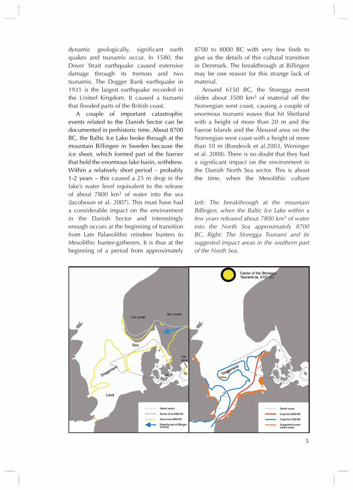
A couple of important catastrophic events related to the Danish sector can be documented in prehistoric time . About 8700 BC, the Baltic Ice Lake broke through at the mountain Billingen in sweden because the ice sheet, which formed part of the barrier that held the enormous lake basin, withdrew . Within a relatively short period – probably 1-2 years – this caused a 25 m drop in the lake’s water level equivalent to the release of about 7800 km3 of water into the sea (Jacobsson et al . 2007) . This must have had a considerable impact on the environment in the Danish sector and interestingly enough occurs at the beginning of transition from Late Palaeolithic reindeer hunters to Mesolithic hunter-gatherers . It is thus at the beginning of a period from approximately
8700 to 8000 BC with very few finds to give us the details of this cultural transition in Denmark . The breakthrough at Billingen may be one reason for this strange lack of material .
Around 6150 BC, the storegga event slides about 3500 km3 of material off the Norwegian west coast, causing a couple of enormous tsunami waves that hit shetland with a height of more than 20 m and the Faeroe Islands and the Ålesund area on the Norwegian west coast with a height of more than 10 m (Bondevik et al .2003, Weninger et al . 2008) . There is no doubt that they had a significant impact on the environment in the Danish North sea sector . This is about the time, when the Mesolithic culture
Left: The breakthrough at the mountain Billingen, when the Baltic Ice Lake within a few years released about 7800 km3 of water into the North Sea approximately 8700 BC. Right: The Storegga Tsunami and its suggested impact areas in the southern part of the North Sea.

6
in Denmark orientates itself on marine resources . Could the storegga Tsunami have played a role in this transition?
To understand the cultural development in the North sea area it is important to let go of an unfortunate assumption that has long been embedded in archaeological thinking . This is the idea that ice covers of prehistoric glaciations were physical barriers for human culture . As the seawater temperature will not be below 0˚C, the sea is often too warm for an ice cover to exist in its immediate vicinity . A corridor of 50-100 km along the coast, which is free of ice, is a normal phenomenon . such a corridor will offer access to rich maritime resources as well as terrestrial ones . In Greenland, this is exactly the biotope present Inuit and Palaeo Eskimo Cultures exploited . Thus one must keep in mind that migration around the ice cover is an option, and that cultural interaction between the North sea Region and Russia and siberia, which was practically without ice cover during the last glaciation due to low precipitation in the northern areas, should not be excluded a priori .
To put it a bit blunt our studies of the hunting and gathering cultures of the Old stone Age on dry land may just have been like peeping through a key hole, missing the important coastal aspects of the cultural
processes for the main part of the period when the sea level was considerably below that of today . In analogy to the aboriginal population of Australia, where competition existed over territories on the productive coast (sutton 1990), it is well possible that we have so far, in our archaeological studies on dry land, been dealing with the prehistoric groups that were not successful in such a competition!
Management and investigation of sites. The Baltic experience shows that the degree of preservation of submerged stone Age sites and landscapes varies significantly from area to area . In some areas, erosion has been the
Left: The ice free corridor of 50-100 km along the Greenland coast – from Google Earth. Right: The temperature variation between Karasjok 70 km inland and Lakselv on the coast at the bottom of the 120 km long Porsanger Fjord in northern Norway measured on a sunny winter day. Red curve – morning temperatures. Blue curve – mid day temperatures. Even the restricted buffer effect of the water of the fjord basin increases the air temperature with about 10˚C. At times the difference here can be up to 20˚C.

7
rule, and material that is still preserved will have been transported away from its location of first deposition . such a situation prevails in the Danish belts, where the bottom in large areas has been eroded down to and into the moraine subsoil, with only preservation of the deeper part of truncated peat bog basins . In such areas, bathymetry is often a bad indicator of changes in a no longer existing original surface topography .
Fluviatile and longshore transportation of material that can be observed in the coastal zones reflects erosion in some areas and sedimentation in others . With the complex geological processes that have formed the landscape, preserved cultural landscapes may well be buried under layers of sediment of varying thickness . Experience has shown, however, that one should not be too pessimistic . There is a good chance that the sea has preserved large, intact and extremely informative parts of prehistoric landscapes .
As maritime archaeologists our most important task at the moment is to support the development of methods that allow cost-effective mapping of and data collec-
tion from submerged sites and cultural landscapes, so that management of and research in this very important cultural resource can develop into a smooth and well functioning practice . A number of promising methods and technologies are already under development and will hopefully underpin this development .
Ole Grøn & Lars Froberg Mortensen
Notes1) All datings in this paper are given in cal . years BC .
Left: Position of core profile in GEUS’ core database JUPITER. Right: The profile running from the Oksbøl area in east (R) to the Dogger Bank in vest (L). The peat and gyttja layers document earlier phases with sea levels significantly below that of today.

8
ReferencesBailey, G .N ., Milner, N .J . 2002 . Coastal
hunters and gatherers and social evolution: marginal or central? Before Farming: the Archaeology and Anthropology of
Hunter-Gatherers 3-4 (I): 1- 15 .Bondevik, s ., Mangerud, J ., Dawson, s .,
Dawson, A ., Lohne, Ø . 2003: Record-breaking Height for 8000-Year-Old Tsunami in the Nordic Atlantic . Eos, Vol . 84, No . 31, 5 August 2003 . 289-300
Erlandson, J .M . 2001 . “The archaeology of aquatic adaptations: paradigms for a new millennium .” Journal of Archaeological Research 9:287-350 .
Fischer, A . 2004 . “submerged stone Age – Danish Examples and North sea Potential” . Flemming, N .C ., (ed .) 2004 . Submarine Prehistoric Archaeology of the North Sea: Research Priorities and Colla-boration with Industry. Council for British Archaeology Research Report 141 , York .
Flemming, N .C ., ed . 2004 . Submarine Prehistoric Archaeology of the North Sea: Research Priorities and Collaboration with Industry . Council for British Archaeology Research Report 141 , York .
Gaffney, V ., Thomson, K ., and Fitch, s . (eds) 2007 . Mapping Doggerland: the Mesolithic Landscapes of the Southern North Sea . Archaeopress, Oxford .
Grøn, O . 1998: “Neolithization in southern scandinavia – A Mesolithic perspective” . M . Zvelebil, R . Dennell and L . Domanska (eds) Harvesting the Sea, Farming the Forest: The Emergence of Neolithic Socie-ties in the Baltic Region . sheffield . 181-91 .
Harff, J ., Lemke, W ., Lampe, R ., Lüth, F ., Lübke, H ., Meyer, M ., Tauber, F ., and schmölcke, u . 2007 . The Baltic Sea coast – a model of interrelations among geosphere, climate, and anthroposphere. Geological Society of America, special Paper 426 . 133- 142 .
Jakobsson, M ., Björck, s ., Alm, G ., Andrén, T ., Lindeberg, G ., svensson, N .-O . 2007: Reconstructing the Younger Dryas
ice dammed lake in the Baltic Basin: Bathymetry, area and volume. Global and Planetary Change, 57 (2007) . 355-70
Lykke-Andersen, H ., Borre, K ., 2000: “Aktiv tektonik i Danmark – der er liv i sorgenfrei-Tornquist Zonen” . Geologisk Nyt 6/2000 . 12-13
Pedersen, L ., Fischer, A ., Aaby, B . (eds) 1997: The Danish Storebælt since the Ice Age . A/s storebælt Fixed Link, Copenhagen . 319-24 .
skaarup, J ., and Grøn, O . 2004 . “Møllegabet ll: A submerged Mesolithic settlement in southern Denmark” . British Archaeo-logical Reports International Series 1328 . Archaeopress, Oxford .
sutton, Peter 1990 . “The pulsating heart: large scale cultural and demographic processes in Aboriginal Australia” . B . Meehan & N . White (eds) Hunter-gatherer demography past and present . sydney: Oceania Monographs . 71-80
Weninger, B ., schulting, R ., Bradtmöller, M ., Clare, L ., Collard, M ., Edinborough, K ., Hilpert, J ., Jöris, O ., Niekus, M ., Rohling, E .J ., Wagner, B . 2008: “The catastrophic final flooding of Doggerland by the storegga slide tsunami” . Documenta Praehistorica XXXV (2008) .
9
Footwear from HMs st George
HMS St George was a 1950 ton second rate British Naval ship built in Portsmouth in 1785 . Its gun deck length was 177ft 6in, its beam was 50ft 3in and its hold depth was 21ft 2in . After 26 years of naval service, this enormous ship of the line was wrecked off the coast of Jutland on Christmas Eve 1811 . With only 12 survivors of approximately 865 onboard, it is one of the worst disasters in British Naval history . HMS St George proves to be one of the few well preserved shipwrecks from the Napoleonic wars, and a number of salvage attempts and excavations have been carried through . A large collection of material culture has been conserved and is on exhibition in the strandingsmuseum in Thorsminde, where the assemblage is currently studied by students of the Maritime Archaeology programme . The present article is based on a Master’s thesis dealing with the footwear recovered during the 1983-86 excavations .
Footwear construction during the early nineteenth century was obviously the first theme of research . The second theme was to study the use, wear, degradation and formation processes in general that have affected this group of items, taking inspiration from a number of influential theorists, such as schiffer, Muckelroy and Gibbs . Thirdly, this information has been used to make inferences about life onboard and why some
footwear continued to be used despite its poor condition .
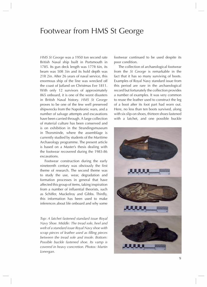
The collection of archaeological footwear from the St George is remarkable in the fact that it has so many surviving of boots . Examples of Royal Navy standard issue from this period are rare in the archaeological record but fortunately the collection provides a number of examples . It was very common to reuse the leather used to construct the leg of a boot after its foot part had worn out . Here, no less than ten boots survived, along with six slip-on shoes, thirteen shoes fastened with a latchet, and one possible buckle
Top: A latchet fastened standard issue Royal Navy Shoe. Middle: The tread sole, heel and welt of a standard issue Royal Navy shoe with scrap pieces of leather used as filling pieces between the tread sole and insole. Bottom: Possible buckle fastened shoe. Its vamp is covered in heavy concretion. Photos: Martin Lonergan.

10
fastened shoe . In addition, ten less complete items could be studied, so forty artefacts in all . Almost all material provides evidence for so-called ‘welt’ construction and it is very likely that the whole collection was welt constructed as there is no evidence to prove the contrary . The welted method evolved around 1500 and continues to be used today . The upper leather has a small strip of leather attached to its outside bottom edge, which in turn is attached to the sole . Despite the uniform construction, there is variation in design, mainly related to the way in which the top of the shoe had its individual parts attached . Common characteristics of how the heel was attached to the sole and how the footwear was fastened to the foot define the types, and makers marks were identified on the tread soles of the footwear, making it possible to identify a number of shoes made by the same shoemaker .
The most obvious natural process affecting the footwear is deterioration of the stitching . When stitching deteriorates, components can become detached . The exception is the heel, which is generally also nailed to the tread sole with wooden or metal nails . Occasionally, the heel detaches from the tread sole and discoloration, organic material and concretions have been discovered on tread soles . In a small minority of the tread soles, parts are missing, having deteriorated due to the effects of natural formation processes . Among the footwear that was constructed using midsoles, some only remain in small fragments . Cracking and rust spots have been identified in a small number of insoles . Concretions, grey stains, sea encrustation, and organic material have also been discovered on the surface of vamps .
Apart from these transforms that can be related to natural processes, the material displays traces of use and conscious human action . The heel is generally worn at the rear on its lateral side or on its straight edge . The tread sole displays the effects of wear and most commonly in the area of the ball of the
foot . When the tread sole is worn through, there is often wear on the insole . After preservation some components of footwear remain in a very hardened condition, and use is evidenced by creases or very small folds in the leather .
Conscious behaviour can be shown from the condition artefacts are recovered in, for example a pair of boots that are bound together by a lace threaded through a lace hole in each boot or a concretion in the inner of a shoe that may be a result of a number of coins being placed there .
The physical evidence of wear and
Top: A pair of lace fastened boots bound together by a lace threaded through a lace hole in each boot. Bottom: A slip-on shoe containing organic material. Photos: Martin Lonergan.

11
conscious action has been used for inference about life onboard in combination with the known historical record . There is one activity that can be suggested as cause of wear on the tread sole in the area the ball of the foot sits directly over . It is the use of the capstan to raise the anchor or heavy cargo . Crews pushing the capstan bars were likely to push utilising the maximum force from their legs by pushing on the balls of their feet . Another activity that may be suggested as a cause of this formation process is the handling of the ships gunnery . Running out a loaded gun upslope because a ship is heeling would involve pulling very hard on the gun tackles and also pushing the gun from the rear . During this activity, it is possible that the seamen tried to utilise the balls of their feet for extra grip . The evidence suggests that they wore shoes during these activities . As mentioned the examination has shown that the heel is worn at the rear on its lateral side and in some cases the straight edge of the heel is extremely worn . A possible explanation for this is fitting the lower sail to the yard, also known as ‘bending sails’ . During this process crew were stationed along the yard, upper bodies slung over the yard and their feet positioned on a rope below the yard to help keep balance while aloft . Their job was
to tie the sail to the yard with ropes once the crew on deck had hauled it to the yard .
The wear encountered on tread soles was quite extensive . In some cases, the thickness of the tread sole was worn through, and the underside of the insole was also worn . Wearing footwear in this condition could have been very uncomfortable . One explanation would be that no replacements were in stock, returning from a campaign . Another is that the seamen had to pay for their shoes themselves . According to Royal Navy records dated 1807 the monthly pay for an ordinary seaman is 1 pound 5 schillings and 5 pence . In the pursers account book of HMS Victory dated 1803, the price of a pair of shoes listed among the slops price list is stated as 6 schillings . Presuming the cost of a pair of shoes was roughly the same in 1811 or a bit more, it is roughly the equivalent of one weeks wages for an ordinary seaman . In view of this, some may have postponed to buy new shoes until the old ones were completely impossible to wear .
Research of the footwear has once more illustrated the uniqueness of the HMS St George collection . The number of unexpected finds such as concretions, organic material, and rope is significant as it demonstrates that it is possible that extra data can be gained from footwear by observing what footwear may contain or ‘carry .’ It has demonstrated that the application of formation process theory to individual artefacts coming from a marine environment gives a fresh perspective .
Martin Lonergan
Bending the sail to the yard, the crew is stationed along the yard with their feet positioned on a rope below the yard, after Brian Lavery, Shipboard Life and Organization, Ashgate 1998.

12
Viking Age Iconographyand the square sail
Considerable effort has been spent over the last thirty years in building and testing reconstructions of Viking and medieval ships, not the least at the Viking ship Museum in Roskilde, Denmark . Various preliminary papers on these ships have been published, and a full report on the recon-struction and trials of the five skuldelev ship reconstructions is now in preparation, describing in detail the building principles and seafaring potentials of these five 11th century ships, comprising large and small warships and cargo ships, as well as a fishing boat .
The archaeological base of evidence for these five reconstructions has been published in detail . As a result of the careful recording, analysis and reassembly of all parts of the timbers of the hulls it has been possible to reconstruct the size, structure, and lines of the hulls of the original ships within narrow limits, respecting all features recorded in the archaeological evidence .
In one of the ships, Skuldelev 3, many features related to the rigging have also been observed, such as the position of the mast, as well as the cleats for shrouds and halyard and the holes for the sheet and tack . This has defined the length of the lower leech of the sail and the basic geometry of the handling of the sail . Thus, only the height of the mast is an open question in the reconstruction of the rigging of this ship . since Roar Ege was built in 1982-84 as the first of the skuldelev ship reconstructions, the analysis of evidence for this square sail reconstruction from all
In number 22 of this newsletter, Ole Kastholm (2007) uses iconography to challenge the proportions of reconstructed Viking Age sails. In Aarbøger, Kastholm (2009) reiterates his arguments. It is time for a reply.
available archaeological, ethnological and sail technical sources as well as the outcome of the sea trials has been extensively pub-lished in 1989 and 1997 .
For the other skuldelev ships, there was less evidence in the hulls for the recon-struction of their rigs, and consequently the positive experience from Roar Ege played an important role in designing their rigs, yet adapted to the individual characteristics of the broad cargo ships and the narrow warships . The resulting rigs of more or less square shapes have all functioned well in extensive trials over the years . They have taken the ship reconstructions on straining voyages across some of the rough seas for which the original ships were built . This indicates that these rig reconstructions have been functional and successful, even if it does not serve as a final proof that these
The five Skuldelev ships as reconstructed with complete hulls and rigs. The reconstruc-tions integrate the best possible combination of archaeological, ethnological, and sail tech-nical data. Proportions of the rig vary for the individual ships. The Viking Ship Museum, Roskilde.
13
rigs were identical in detail to those of the original ships .
Now, the question has been raised whether some of these rigs are basically incorrect . In a short note in the 2007 issue of this Newsletter, Ole Kastholm questioned the principles on which some of the skuldelev rigs have been reconstructed . While he fully accepted the validity of the skuldelev 3 evidence, he claimed that the warships would have had much broader sails based on the pictorial evidence of the ships on the 9th-10th century ornamented stones from Gotland and some contemporary coins and rune stones .
The basis for these statements was more extensively published in 2009 . Here, not only the statistical data of the hulls and parts of the rigging of the 36 images chosen for the study were given, but also the author’s approach to their value as evidence of ships of the ‘real world’ of the 9th-10th centuries . He stressed the archaeological source value of the images, which he considered as equivalent to the evidence of the excavated physical remains of the ships themselves . since many realistic details are shown in the images, and as there is agreement between some of the profiles of the hulls of 9th century images and the Oseberg ship of the same period, he concluded that the essential common denominator was the ‘reality’ of these ship motifs, also regarding their rigs . Postulating this fundamental realism of the ship motifs was for Kastholm the only way to take advantage of this source of evidence, and if that was not accepted, this evidence would crumble away for him in the research process (Kastholm 2009: 106) .
With this fundamental realistic approach, there was little room for an analysis of non-technical aspects of the images, including a source critical approach to
their iconographic conventions, context, or inherent messages . Kastholm dealt with the revised dates for some of the stones provided by recent research but did not look into the problem that icons often preserve outdated features in their symbolic messages . Therefore, only seldom can they serve as updated representations of the motifs, even in cases when these have a realistic everyday background .
The Tullstorp rune stone of c AD 1000 with images related to the Ragnarok myth. After Molke, 1985.
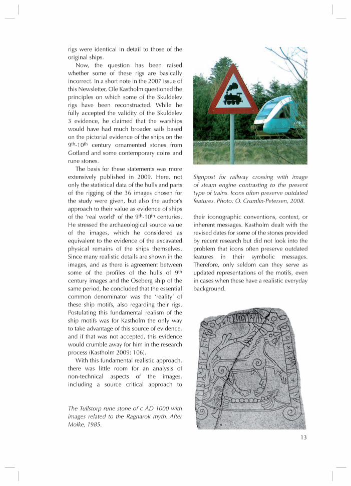
Signpost for railway crossing with image of steam engine contrasting to the present type of trains. Icons often preserve outdated features. Photo: O. Crumlin-Petersen, 2008.
14
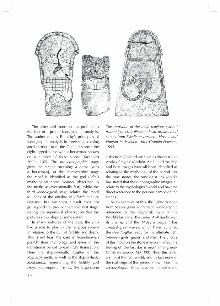
The other and more serious problem is the lack of a proper iconographic analysis . The author quotes Panofsky’s principles of iconographic analysis in three stages, using another motif from the Gotland stones: the eight-legged horse with a horseman, shown on a number of these stones (Kastholm 2009: 107) . The pre-iconographic stage gives the simple meaning: a horse [with a horseman], at the iconographic stage the motif is identified as the god Odin’s mythological horse Sleipner [described in the myths as exceptionally fast], while the third iconological stage relates the motif to ideas of the afterlife in 8th-9th century Gotland . But Kastholm himself does not go beyond the pre-iconographic first stage, stating the superficial observation that the pictures show ships at some detail .
In many cultures of the past, the ship had a role to play in the religious sphere in relation to the cult of fertility and death . This is not least the case in scandinavian pre-Christian mythology and even in the transitional period to early Christianisation . Here the ship-of-death, Naglfar of the Ragnarok myth, as well as the ship-of-luck, Skidbladnir, representing the fertility god Freyr, play important roles . The large stone
slabs from Gotland are seen as ‘doors to the world of myths’ (Andrén 1993), and the ship and boat images have all been identified as relating to the mythology of the period . For the rune stones, the runologist Erik Moltke has stated that their iconographic images all relate to the mythological world and have no direct reference to the persons named on the stones .
As an example of this, the Tullstorp stone from scania gives a dramatic iconographic reference to the Ragnarok myth of the World’s last days . The Fenris Wolf has broken its chains, and the Midgård Serpent has created great waves, which have launched the ship Naglfar ready for the ultimate fight between gods, giants, and men . The choice of this motif on the stone may well reflect the feeling of ‘the last day is near’ among non-Christians around AD 1000 . Thus, this is not a ship of the real world, and in fact none of the real ships of this period known from the archaeological finds have similar stem and
The transition of the main religious symbol from ship to cross illustrated with ornamented stones from Eskelhem Larsarve, Husby, and Høgran in Sweden. After Crumlin-Petersen, 1995.
15
stern shapes . It is, however, possible that such stem shapes were used centuries earlier in ships and that they were introduced to the iconographic world at that stage .
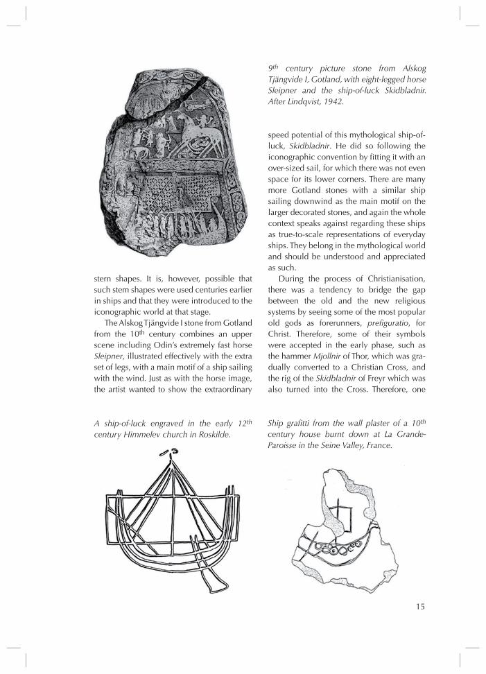
The Alskog Tjängvide I stone from Gotland from the 10th century combines an upper scene including Odin’s extremely fast horse Sleipner, illustrated effectively with the extra set of legs, with a main motif of a ship sailing with the wind . Just as with the horse image, the artist wanted to show the extraordinary
speed potential of this mythological ship-of-luck, Skidbladnir . He did so following the iconographic convention by fitting it with an over-sized sail, for which there was not even space for its lower corners . There are many more Gotland stones with a similar ship sailing downwind as the main motif on the larger decorated stones, and again the whole context speaks against regarding these ships as true-to-scale representations of everyday ships . They belong in the mythological world and should be understood and appreciated as such .
During the process of Christianisation, there was a tendency to bridge the gap between the old and the new religious systems by seeing some of the most popular old gods as forerunners, prefiguratio, for Christ . Therefore, some of their symbols were accepted in the early phase, such as the hammer Mjollnir of Thor, which was gra-dually converted to a Christian Cross, and the rig of the Skidbladnir of Freyr which was also turned into the Cross . Therefore, one
9th century picture stone from Alskog Tjängvide I, Gotland, with eight-legged horse Sleipner and the ship-of-luck Skidbladnir. After Lindqvist, 1942.
A ship-of-luck engraved in the early 12th century Himmelev church in Roskilde.
Ship grafitti from the wall plaster of a 10th century house burnt down at La Grande-Paroisse in the Seine Valley, France.

16
may still find the ship-of-luck icon in an early 12th century context, here, with the broad sail even more pronounced than before .
In contrast, in the seine Valley of France during the 9th and 10th centuries, Viking ships on the river were a reality, which the local inhabitants had good reasons to fear . A casual graffiti in the wall clay of a burnt-down 10th century house close to the river has preserved the impression of a Viking warship, showing a sail of similar proportions as those used with the skuldelev reconstructions . Here the ship-of-fear of their everyday reality was shown, and indeed not the Viking’s own mythical ship-of-luck with its broad sail .
Consequently, returning to Kastholm’s own example with the eight-legged horse Sleipner: regardless of the number of depictions one may find of such a horse on the Gotland stones, this creature does not become a reality . The same is the case with the hull shape of Naglfar or the rig proportions of Skidbladnir; these images of the 9th and 10th
centuries are mental creations, transforming visual elements of actual ships of their own age and rudimentary elements from older ships to match graphic conventions and mythological tales . They can not serve as patterns when reconstructing the ships of the real world, such as the 11th-century skuldelev ships . Here an analysis of the near-contemporary ships on the Bayeux tapestry, in the context of another iconographic medium, would have been more relevant and informative .
Ole Crumlin-Pedersen
ReferencesAndersen, B . & Andersen, E . 1989: Råsejlet
– Dragens vinge . Vikingeskibshallen . Roskilde .
Andersen, E ., O . Crumlin-Pedersen, s . Vadstrup & M . Vinner 1997: Roar Ege. Skuldelev 3 skibet som arkæologisk ekspe-riment . Vikingeskibshallen i Roskilde .
Andrén, A ., 1993: “Doors to other Worlds:
scandinavian Death Rituals in Gotlandic Perspectives” . Journal of European Archaeology 1: 33-56 . Avebury .
Bill, J ., s . Nielsen, E . Andersen & T .D . sørensen 2007: Wellcome on board! The Sea Stallion from Glendalough. A longship recreated . The Viking ship Museum, Roskilde .
Capelle, T ., 2005: “Hedensk og kristen tro i Norden – en anspændt sameksistens” . In T . Capelle & C . Fischer (eds) Ragnarok. Odins Verden, 167-77 . silkeborg Muse-um . silkeborg .
Crumlin-Pedersen, O ., 2005: “skibet i kulten”, in T . Capelle & C . Fischer (eds) Ragnarok. Odins Verden, 143-66 . silkeborg Museum . silkeborg .
Crumlin-Pedersen, O ., 2009: “Boats and ships in the 9th- and 10th-century Baltic – the archaeological and iconographic evidence”, in Englert, A ., & A . Trakadas (eds), 2009: Wulfstan’s Voyage. The Baltic Sea region in the early Viking Age as seen from shipboard. Maritime Culture of the North 2: 235-56 . The Viking ship Museum, Roskilde .
Crumlin-Pedersen, O ., et al ., 2002: The Skuldelev Ships I. Topography, Archaeology, History, Conservation and Display . ships and Boats of the North 4 .1 . Roskilde .
Kastholm, O .T ., 2007: “Viking Age Icono-graphy and the square sail” . Maritime Archaeology Newsletter from Denmark 22, 8-12 .
Kastholm, O .T ., 2009: “De gotlandske billedsten og rekonstruktionen af vikinge-skibenes sejl” . Aarbøger for nordisk Oldkyndighed og Historie 2005: 99-159 .
Moltke, E ., 1985: Runes and their Origin, Denmark and Elsewhere . The National Museum of Denmark . Copenhagen: 249 .
simek, R ., 2003: Religion und Mythologie der Germanen . Theiss Verlag, Darmstadt .
Vadstrup, s ., 1993: I vikingernes kølvand. Erfaringer og forsøg med danske, svenske og norske kopier af vikingeskibe 1892-1992 . Vikingeskibshallen i Roskilde .
17
IntroductionBuilding dams in streams and rivers has been an integral part of human civilisation from its early history . Dams have been created to control floods, improve navigation, provide drinking water supplies, create or enhance recreational opportunities, and provide water for irrigation and other agricultural uses . Norway is no exception . since the 16th century, inland waters have been blocked with barrages to accommodate timber rafting and transport . From around the 1890s, the time of the second industrial revolution, dams were built to produce electrical power .
since 1960, all new damming requires a license from the Ministry of Oil and Energy . To get a license, or to renew an existing one, power producers are now obliged to do archaeological research in the area that is being affected . For dams built before 1960 no archaeological survey or excavation has been carried through . Presently 21 of the 25 biggest inland lakes in Norway are affected by damming projects that are under realisation (Inderlid 2009:13) . There should be great potential for underwater archaeology in some of these areas, not least in relation to Mesolithic sites . But where to focus the effort? These are large tracts of water, that are hard to survey in a reasonable timeframe . This paper, which is based on my master thesis at sDu, describes an attempt to model the chances of finding well preserved organic material under water in these areas . Predictive modelling techniques have been used to locate underwater areas that might be worth extra attention, for instance by extending an excavation that is undertaken adjacently on dry land . such predictive – or better: “indicative” – models are one of the few non-destructive methods by which a wide area can be evaluated so as to guide
Those Dammed Waters
archaeological efforts (Wheatley & Gillings 2002:165) .
Model descriptionA major challenge in developing an indicative model in the present context is that there are not many sites to base the work on . Very little attention has been paid to the underwater heritage of the inland waters of Norway, and only in a few instances diving has been employed . Therefore, a deductive approach must be used in making the model . In designing it, I have used the weighted value method to indicate where well preserved sites can be located . As implied by its name, this method weighs different variables differently . This is a two step process . Each landscape variable (like geology etc .) is first divided into categories, and these are assigned values (V) according to their positive or negative effect on preservation . secondly the relative impact of different variables is assessed in a weighted number (W) . To get the weighted value for each landscape category, the general weight of the variable (W) is multiplied by the individual value of the category (V) . The model then indicates the chances of archaeological finds by summing up all weighted values that are the product of the weight and value of categories and variables in the area (Della Bona 1994:18) . One advantage of this method is that it can all be done in a standard GIs package, which is available to most heritage institutions today .
The variables are chosen according to statistical and numerical data about erosion and how archaeological artefacts are affected by influences from natural and human impact . To a certain extent the variables seem obvious, if one knows the area modelled, but the development of a geographical model for

18
an area highlights these factors so that one can act in a more focused manner when archaeological research is conducted in the area . The model can be refined as more information, finds, and understanding is used to feed back into the model .
The values (V) are defined on the basis of effects on preservation in the underwater environment . They are defined as 1, 0, and -1 . In one case, I have chosen to subdivide this range, using an intermediate value (-0 .5) to describe an intermediate distance from the water discharge . Each category needs to be placed in one of these three groups that can also be called; “good”, “neutral”, and “bad” . This seemingly simple division proved useful, because the categories of the variables do not always display minute differences that would warrant very detailed valuing . One soil type is not a little bit better than the next, rather a group of soil types have more or less equal conditions, so they fit into a wider group .
The variables were then given a relative weight . The lack of an empirical foundation in the form of actual underwater investigations makes it difficult to weigh the relevance of the chosen variables . One needs to use expert judgement and common sense . I chose the weights after consulting with an archaeologist with long-term experience in the region .
The weighted value method implies multiplying the weight of the variable and the value of each category . The resulting values are then added up to give the final value for a specific map unit . Areas with the highest number are assumed to have the best preservation .
The table below gives an overview of the variables and their weight as well as their values . In the last column, the category’s weight is multiplied by the value of the variable .
Map information about the different variables was gathered at Norges Geologiske
19
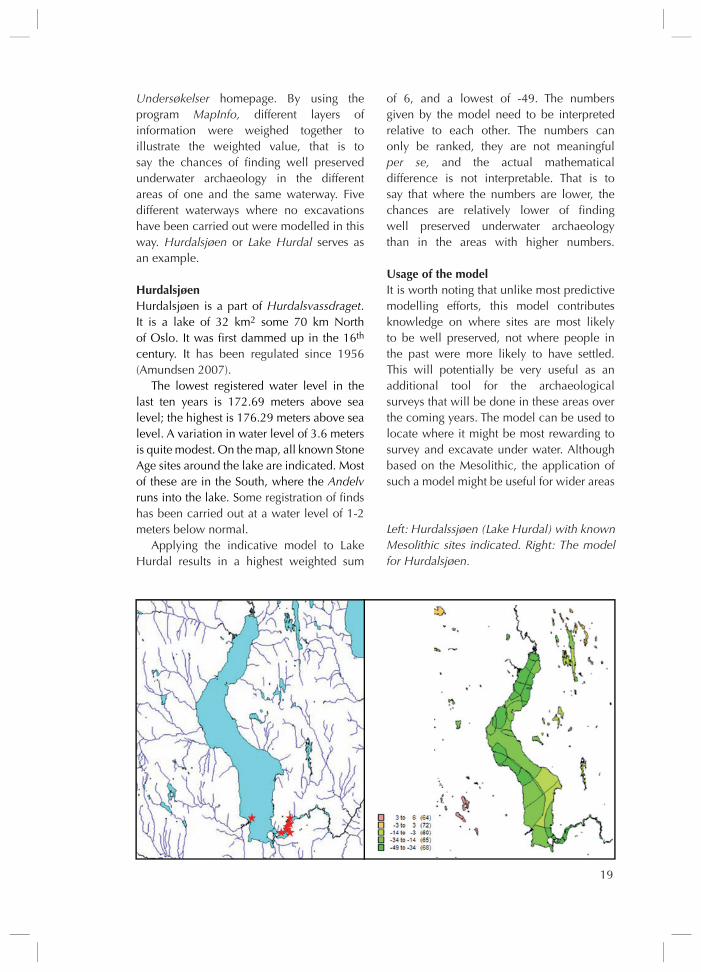
Undersøkelser homepage . By using the program MapInfo, different layers of information were weighed together to illustrate the weighted value, that is to say the chances of finding well preserved underwater archaeology in the different areas of one and the same waterway . Five different waterways where no excavations have been carried out were modelled in this way . Hurdalsjøen or Lake Hurdal serves as an example .
HurdalsjøenHurdalsjøen is a part of Hurdalsvassdraget . It is a lake of 32 km2 some 70 km North of Oslo . It was first dammed up in the 16th century . It has been regulated since 1956 (Amundsen 2007) .
The lowest registered water level in the last ten years is 172 .69 meters above sea level; the highest is 176 .29 meters above sea level . A variation in water level of 3 .6 meters is quite modest . On the map, all known stone Age sites around the lake are indicated . Most of these are in the south, where the Andelv runs into the lake . some registration of finds has been carried out at a water level of 1-2 meters below normal .
Applying the indicative model to Lake Hurdal results in a highest weighted sum
of 6, and a lowest of -49 . The numbers given by the model need to be interpreted relative to each other . The numbers can only be ranked, they are not meaningful per se, and the actual mathematical difference is not interpretable . That is to say that where the numbers are lower, the chances are relatively lower of finding well preserved underwater archaeology than in the areas with higher numbers .
Usage of the modelIt is worth noting that unlike most predictive modelling efforts, this model contributes knowledge on where sites are most likely to be well preserved, not where people in the past were more likely to have settled . This will potentially be very useful as an additional tool for the archaeological surveys that will be done in these areas over the coming years . The model can be used to locate where it might be most rewarding to survey and excavate under water . Although based on the Mesolithic, the application of such a model might be useful for wider areas
Left: Hurdalssjøen (Lake Hurdal) with known Mesolithic sites indicated. Right: The model for Hurdalsjøen.

20
of underwater archaeology, and not only stone Age archaeology . The variables found important in the model have an effect on the entire underwater landscape, and not on material from one specific time period only .
One of the arguments against predictive modelling has often been that based on variables on the natural environment, they tend to become eco-deterministic . In the work presented here, the model is focussed on natural processes and, therefore, on the ecological impact on cultural heritage, not on the more complex matter of human decision making . As such, the model is just a useful tool, and such critique does not apply . I believe that this kind of model has great potential in relation to dammed waters . Because of the renewal of licenses, archaeological research is planned . If there is well preserved archaeology in these areas, this surely will give additional knowledge about the past . In developing an indicative model that focuses on preservation and quality of the material, the variables that I found useful are all of a hydrological or geological character . Further studies and refinement therefore call for cross-disciplinary cooperation between these professions and archaeologists . To improve the model it is necessary to gather more information, both on the archaeology and on the environment of the area of study . Bathymetry would most likely be useful as a variable, and this can be added if more detailed maps are available in a later study . Detailed swath bathymetry will be a logical next step .
Archaeological excavation should priori-tise areas where much points in favour of good preservation . The underwater environ-ment in general forms such an area, and the work presented above is an attempt to further qualify the state of preservation under water . At least, some of the submerged sites extend on dry land, and a survey of these would further indicate where it would be useful to do archaeological work under water . When more submerged sites are located, the model
can be adjusted and elaborated . statistical analysis can then assist in the choice and weighing of variables .
Liv Lofthus
ReferencesAmundsen, Ø . 2007 Kulturminner og
motorvej. Rapport fra registrering av fre-dede kulturminner langs E6 fra Dal til Minnesund. Akershus fylkeskommune .
Beverfjord, A . (ed .) 2004 “Kulturminner i ferskvann” in Vitark nor. 4. Viten-skapsmuseet, NTNu, Trondheim
Della Bona, L . 1994: Methodological Con-siderations . Cultural resource predictive modeling project volume 4. Center for archaeological resource prediction, Lake-head university, Thunder Bay, Ontario
Inderlid, s . 2009 Arkeologiske undersøkelser i vassdrag Faglig program for Sør-Norge. Riksantikvaren, Oslo
Wheatley, D . & Gillings, M . 2002 Spatial technology and archaeology the archaeo-logical applications of GIS Taylor & Francis . Oxford .
http://www .ngu .no/no/http://www .regjeringen .no/nb/dep/oed .
html?id=750
21
The excavation in 2000 and 2001 of the waterfront at Fiskergade in the old port (Gammelhavn) of Aarhus, along the south side of the Aarhus Å produced some reused boat timbers . The timbers were among more than 600 poles and planks that allowed for a detailed dendrochronological analysis at the National Museum in Copenhagen . On account of this, it has been possible to create a very tight and narrow chronology, with 19 dated phases . The excavation area, 1300 m2 in all, covers six cadastral plots .
Written sources indicate that the owners of the individual riverside plots had to maintain the waterfront . Each waterfront revetment was replaced as the need arose, and there only seem to have been three occasions when the waterfront revetment was replaced in all six plots simultaneously . Construction and frequency of replacement vary a lot from plot to plot . Wickerwork and poles with unsecured revetments of longitudinal planks are two of the variations and all sorts of timber have been used, including building material and parts of dismantled ships . Parts of at least eight different boats were recognised, of which we want to highlight three . using the data for a study on the lifespan of boats made extensive sampling attractive for the National Museum‘s dendrochronological laboratory .
Wreck 1Dendrochronology indicates that the
Reused boat timbers from Aarhus
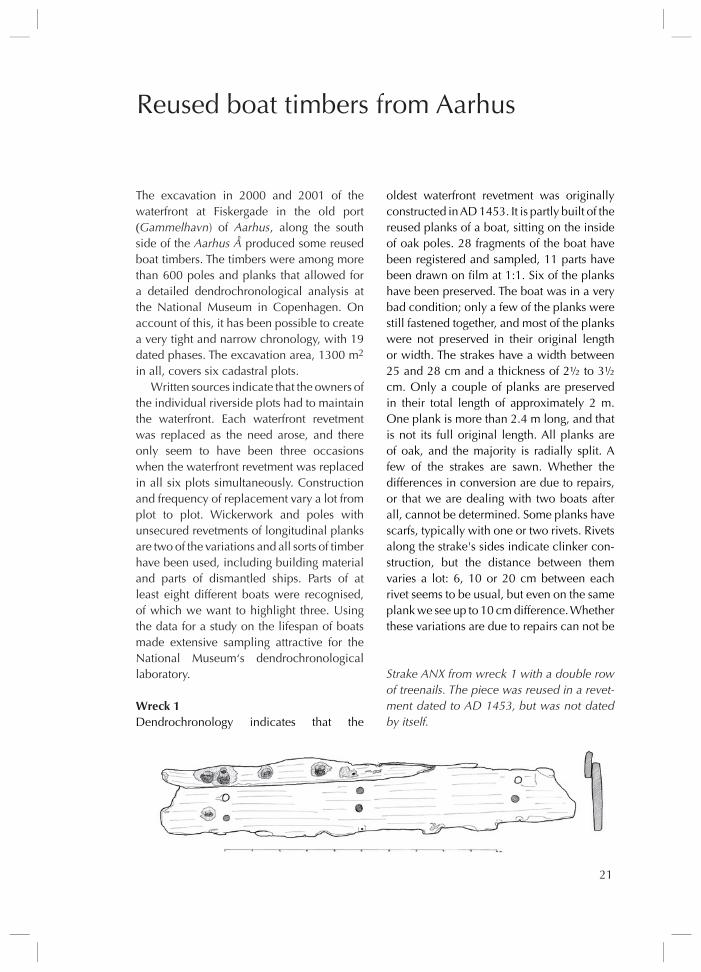
oldest waterfront revetment was originally constructed in AD 1453 . It is partly built of the reused planks of a boat, sitting on the inside of oak poles . 28 fragments of the boat have been registered and sampled, 11 parts have been drawn on film at 1:1 . six of the planks have been preserved . The boat was in a very bad condition; only a few of the planks were still fastened together, and most of the planks were not preserved in their original length or width . The strakes have a width between 25 and 28 cm and a thickness of 2½ to 3½ cm . Only a couple of planks are preserved in their total length of approximately 2 m . One plank is more than 2 .4 m long, and that is not its full original length . All planks are of oak, and the majority is radially split . A few of the strakes are sawn . Whether the differences in conversion are due to repairs, or that we are dealing with two boats after all, cannot be determined . some planks have scarfs, typically with one or two rivets . Rivets along the strake's sides indicate clinker con-struction, but the distance between them varies a lot: 6, 10 or 20 cm between each rivet seems to be usual, but even on the same plank we see up to 10 cm difference . Whether these variations are due to repairs can not be
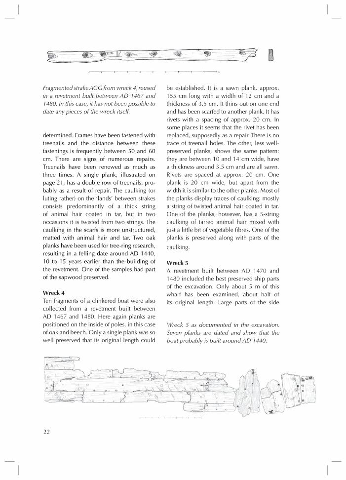
Strake ANX from wreck 1 with a double row of treenails. The piece was reused in a revet-ment dated to AD 1453, but was not dated by itself.
22
determined . Frames have been fastened with treenails and the distance between these fastenings is frequently between 50 and 60 cm . There are signs of numerous repairs . Treenails have been renewed as much as three times . A single plank, illustrated on page 21, has a double row of treenails, pro-bably as a result of repair . The caulking (or luting rather) on the ‘lands’ between strakes consists predominantly of a thick string of animal hair coated in tar, but in two occasions it is twisted from two strings . The caulking in the scarfs is more unstructured, matted with animal hair and tar . Two oak planks have been used for tree-ring research, resulting in a felling date around AD 1440, 10 to 15 years earlier than the building of the revetment . One of the samples had part of the sapwood preserved .
Wreck 4Ten fragments of a clinkered boat were also collected from a revetment built between AD 1467 and 1480 . Here again planks are positioned on the inside of poles, in this case of oak and beech . Only a single plank was so well preserved that its original length could
be established . It is a sawn plank, approx . 155 cm long with a width of 12 cm and a thickness of 3 .5 cm . It thins out on one end and has been scarfed to another plank . It has rivets with a spacing of approx . 20 cm . In some places it seems that the rivet has been replaced, supposedly as a repair . There is no trace of treenail holes . The other, less well-preserved planks, shows the same pattern: they are between 10 and 14 cm wide, have a thickness around 3 .5 cm and are all sawn . Rivets are spaced at approx . 20 cm . One plank is 20 cm wide, but apart from the width it is similar to the other planks . Most of the planks display traces of caulking: mostly a string of twisted animal hair coated in tar . One of the planks, however, has a 5-string caulking of tarred animal hair mixed with just a little bit of vegetable fibres . One of the planks is preserved along with parts of the
caulking .
Wreck 5A revetment built between AD 1470 and 1480 included the best preserved ship parts of the excavation . Only about 5 m of this wharf has been examined, about half of its original length . Large parts of the side
Fragmented strake AGG from wreck 4, reused in a revetment built between AD 1467 and 1480. In this case, it has not been possible to date any pieces of the wreck itself.
Wreck 5 as documented in the excavation. Seven planks are dated and show that the boat probably is built around AD 1440.

23
of the boat – more than 3 .2 m – are used as longitudinal planks behind rammed oak poles, but part of the boat‘s side is sawn into smaller pieces and placed on edge .
Again, it is a clinker boat . The strakes are worn, and there are clear signs of erosion on the outboard of the plank . Many of the planks are split at lap rivets and through treenail holes . When the boat‘s side was reused in the waterfront, all the planks were apparently still nailed together, although on excavation, the vast majority of rivets was so eaten away by rust, that most of the planks had more or less sunken down behind the planks situated in front it . The caulking between the strakes consists of a thick twisted string of tarred animal hair . The distance between the rivets fluctuates between 15 and 19 cm with an average of 17 cm . The distance between the treenail holes is approx . 62 cm on the upper planks, but at the bottom plank there seem to be treenails only for each second frame . All the planks are radially split . They seem to have a width of approx . 24 cm and a thickness of 2-3 cm . Ten scarfs are registered and the vast majority have two outboard rivets . The length of scarf varies, grouping around 15, 25 and 37 cm respectively . The caulking in the scarfs is invariably matted animal hair soaked in tar . In spite of the fact that the boat seems so worn, there are remarkably few obvious repairs other than two small strakes of beech .
Tree-ring research extended to 13 samples from seven planks . They derive from trees that have been felled around AD 1440 or a little later . None of the samples had sapwood preserved . It seems likely that the ship had an age of 30 to 40 years before it was reused in the revetment .
Other boat fragmentsTwo pieces of somewhat fragmented strakes (Wreck 2) have been found in the deposit behind a wickerwork revetment dated to spring AD 1457 . One is a radially split plank of about 2 cm thick with traces of two rivets approx . 20 cm apart . The second is a small
piece with a rivet and traces of animal hair caulking and tar . It can not be determined whether the two planks originate from the same vessel . The best-preserved plank is dated to after AD 1424, and accordingly the strake has a maximum age of 32 years .
A strake (Wreck 3) was found among reused timber from a house destroyed by fire, in a wharf built between AD 1467-80 . The piece has been preserved .
A strake (Wreck 6) was reused as a horizontal timber lying in a wharf built early in AD 1513 . The plank is 60 cm long, but not preserved in its original length and has a width of 23 cm . There are three rivets with a spacing of approx . 20 cm .
A T-shaped keel (Wreck 7) with a length of approx . 170 cm and with a maximum width of approx . 20 cm was reused in a bulwark that was constructed in spring AD 1548 .
Finally, a strake (Wreck 8) was found in the deposit behind a wharf that was also dated to the spring of 1548 . The somewhat damaged plank is sawn, and there are traces of rivets and a single treenail hole .
In summary, there are remains and smaller fragments from at least eight different boats, all of which must be regarded as smaller vessels . All the boats are constructed with clinker-built planks, the strakes are fastened with iron rivets with square roves, and the frame is always fastened to the planks with treenails . The caulking between the planks and in the scarfs is always animal hair from sheep, often nearly soaked in tar . One of the results in this research is the time span between the building of the boat and the reuse of the very same boat timber . In one case, the boat was approx . 10-15 years old when it was given up and reused in the con-struction of a revetment . In comparison to other research we would have expected a much longer time span of use . On the other hand, the two other dated boats are approx . 30 to 40 years old .
Lars Krants Larsen, Claudia Baittinger & Niels Bonde
24
Through the discovery of the FPL 77 wreck (see newsletter 25, p . 23) clinker vessels that are converted with flush planks suddenly caught my attention, and converted clinker vessels thus became the subject of my master thesis in maritime archaeology . FPL 77 is one among nine similar wrecks, each built in a double planked manner . The inner hull is built in the clinker construction technique, but an outer layer of carvel strakes is nailed on top . In written sources, such ships are sometimes called “doubled” or “double planked boats”, or are described as vessels that have been put in an envelope . I prefer to use the term converted clinker vessels for the group, as “double planked” can mean different things such as vessels built in the double-dutch manner, and putting in an envelope does not seem an appropriate term either .
Here, I would like to take a closer look at the converted clinker vessels we know of with special emphasis on the wreck FPL 77 . The study is divided into three parts: construction and analysis of FPL 77, comparable wrecks, and finally a discussion on converted clinker vessels .
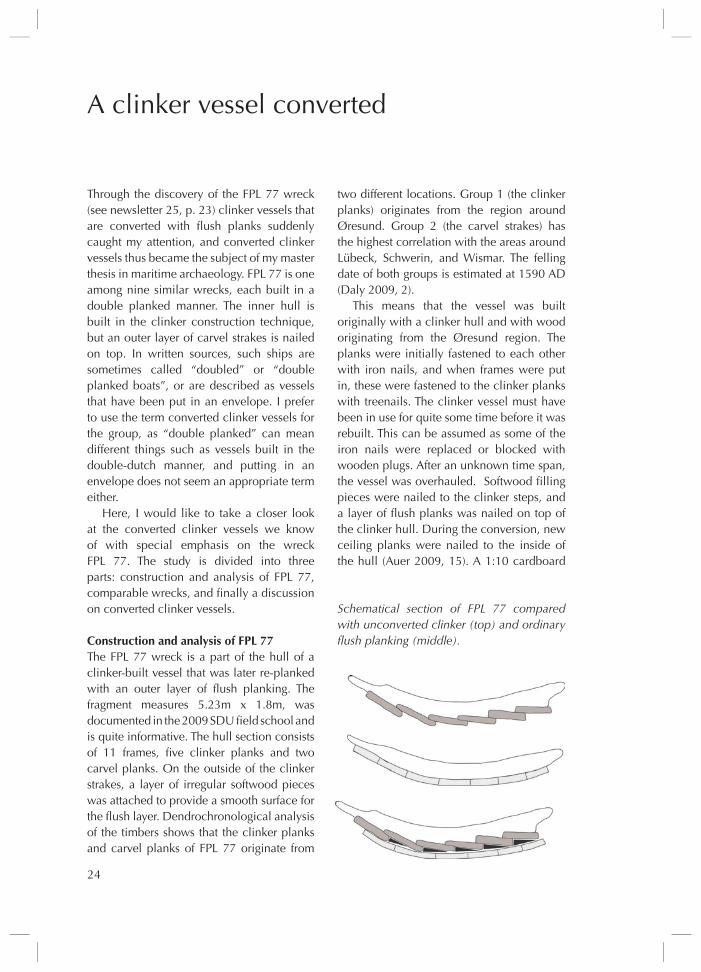
Construction and analysis of FPL 77The FPL 77 wreck is a part of the hull of a clinker-built vessel that was later re-planked with an outer layer of flush planking . The fragment measures 5 .23m x 1 .8m, was documented in the 2009 sDu field school and is quite informative . The hull section consists of 11 frames, five clinker planks and two carvel planks . On the outside of the clinker strakes, a layer of irregular softwood pieces was attached to provide a smooth surface for the flush layer . Dendrochronological analysis of the timbers shows that the clinker planks and carvel planks of FPL 77 originate from
A clinker vessel converted
two different locations . Group 1 (the clinker planks) originates from the region around Øresund . Group 2 (the carvel strakes) has the highest correlation with the areas around Lübeck, schwerin, and Wismar . The felling date of both groups is estimated at 1590 AD (Daly 2009, 2) .
This means that the vessel was built originally with a clinker hull and with wood originating from the Øresund region . The planks were initially fastened to each other with iron nails, and when frames were put in, these were fastened to the clinker planks with treenails . The clinker vessel must have been in use for quite some time before it was rebuilt . This can be assumed as some of the iron nails were replaced or blocked with wooden plugs . After an unknown time span, the vessel was overhauled . softwood filling pieces were nailed to the clinker steps, and a layer of flush planks was nailed on top of the clinker hull . During the conversion, new ceiling planks were nailed to the inside of the hull (Auer 2009, 15) . A 1:10 cardboard
Schematical section of FPL 77 compared with unconverted clinker (top) and ordinary flush planking (middle).
25
model of the wreck was used to infer that FPL 77 was a 10-12 m long vessel with a height of two meters .
Similar findsAs far as I know, eight other converted clinker vessels have been found and recorded archaeologically . They are all from Northern Europe, and most of them are found in the Baltic . Information about these wrecks is summarised in the table on the next page . Analysis of the wrecks in conjunction with written sources led to the following conclusions . There are two clusters of converted clinker vessels: period 1 from ca . 1550-1650 and period 2 from the end of the 18th century to the end of the 19th century . Most of the archaeologically recorded wrecks are from period 1, but a written source from sweden mentions 72 converted clinker vessels from between 1782-1901 (Hasslöf 1970: 59) . Most of the wrecks are from the Baltic area . In three of
them, cargo was found in the form of slaked limestone and brick .
The two groups are also reflected in con-struction techniques . Wrecks in group 2 have butt-end joints in the clinker strakes as well as in the conversion planks . The clinker hulls from period 1 seem to have been built in the typical clinker construction technique, whereas the vessels in group 2 reflect carvel construction .
Purpose of conversionThe final question in the study is: why con-vert clinker vessels into carvel vessels? A range of reasons is suggested .
1 . The conversion was a part of a larger repair: partially or fully doubling plan-king seems to have been a well used method for repairing vessels from far back in time and all the way up to modern times . Repairing clinker planks is more difficult than repairing carvel strakes . Therefore, it is possible that carvel strakes were added on top of the clinker hull in order to make future repairs easier .
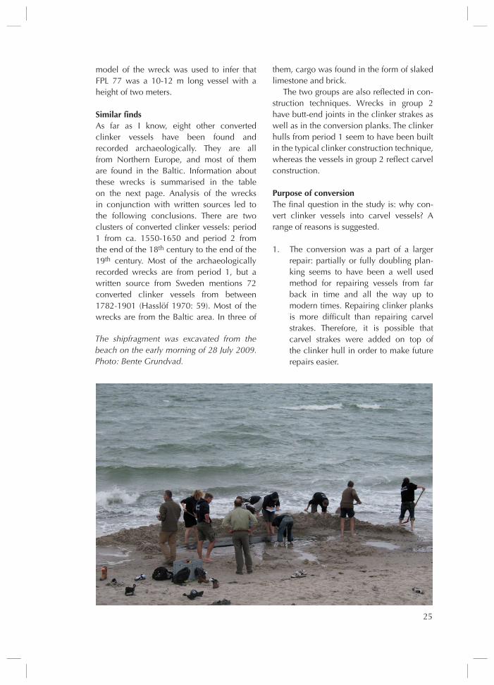
The shipfragment was excavated from the beach on the early morning of 28 July 2009. Photo: Bente Grundvad.

26

27
2 . The double layer was a reinforcement of the hull, making it more watertight: reinforcing the hull with a double layer could be necessary in order to drag ships onto the sandy beaches of the Baltic coast . Reinforcement of the hull was necessity for many vessels in the Baltic, as the sandy shores are rough on the hull when vessels are launched or beached (Mäss 1994) .
3 . The conversion was done for economic reasons: when an old but otherwise well functioning vessel was worn out, its life could be expanded a number of years by adding a carvel layer on top of the clinker hull . This sometimes referred to as “putting the vessel into an envelope” (Hasslöf 1970: 62) .
4 . The double layer was a part of the origi-nal design . If the converted clinker ves-sel was originally built with the double layer, it could illustrate an attempt to follow the new tendencies of building carvel hulls instead of the “old fashion” clinker hulls . The hull construction was therefore based on the rules of the clinker technique but imitated the solutions used on larger ships .
Conclusion When looking at the 16th-17th century converted clinker vessels, it is important to take ongoing changes into account . I would suggest that the first cluster of clinker converted vessels is connected to the recent introduction of carvel construction technique in the Baltic . The exact reasons for the clinker conversion could be many and various . No matter what the exact reason is, it is certain that shipbuilders of the period knew the advantages of a flush-laid hull but may have ignored the basic
construction techniques of such a vessel . By applying an outer carvel layer on top of a clinker built vessel, the shipwright could achieve some of the advantages of flush-laid planking; a modern look, a stronger hull, a more watertight, and a more economically advantageous construction .
Bente Grundvad
ReferencesAuer, J . Et al . 2009 . Fieldwork report. OSTSEE
BEREICH IV, Fischland, FPL 77 . Esbjerg .Daly, A . 2009 . Dendrochronology Report:
4AM Wreck, Darss, Germany FPL 77. Copenhagen: dendro .dk .
Hasslöf, O . 1970 . “Huvudlinjer i skeppsbygg-nadskonstens teknologi” . In O . Hasslöf, H . Henningsen & A .E . Christensen (eds) Sømand, Fisker, Skib og Værft . København .
Mäss, V . 1994 . “A unique 16th century Estonian ship Find” . In C . Westerdahl (ed .) Crossroads in ancient shipbuilding: proceedings of the Sixth International Symposium on Boat and Ship Archaeo-logy Roskilde 1991, 189-94 . Oxbow monograph 40 . Oxford .
Left: An overview of converted clinker vessels compared in this study. Right: The converted clinker vessels compared in this study have been found in all regions of the Baltic.

28
This Newsletter‘s logo is an early medieval ship engraved in the church of Himmelev . Himmelev is a tiny parish that has presently been absorbed in the northeastern suburbs of Roskilde on the Island of Zealand in Den-mark . The image is one out of six ship graffiti, which have only partially been published and dealt with . The present short note tries to remedy that and to put them in focus all six .
Himmelev Church was erected in the first half of the 12th century on a ridge overlooking the inner waters of Roskilde Fjord . In 1972-73, the National Museum of Denmark undertook archaeological investi-gations inside the church on the occasion of a restoration project (cf . report in the NM topographic archive) . A result of this was the revelation of a number of ship graffiti incised
six ship graffiti from Himmelev Church

29
stretching the sail‘s edge when sailing close to the wind, just as seen on some Viking ship motifs as well as on historical square rigged vessels (e .g . Andersen & Andersen 1989; Kastholm 2009, 124) .
Ship 2The vessel beneath ship 1 is similar in style . The high bows and clearly marked strakes are characteristic, and the rigging is almost identical to ship 1, but ship 2 lacks the square sail . The steering oar, however, seems to be a bit clumsier than the one on ship 1, and the sailing direction is opposite . A yard meant for a sail is hoisted in the mast and is evidently of the same approximate dimensions as can be seen in ship 1 .
Ship 3The upper vessel at the west side of the southern door is only partly preserved, with one of the bows missing . Again this is a ship with high bow(s) and marked strakes . The mast is supported by shrouds; four on both sides (fore and aft cannot be distinguished) . Hoisted in the mast is a yard of the same length as the ship .
Ship 4The vessel beneath ship 3 is the sketchiest of the six . Again it is characterised by high bows, but the hull is merely shown through a single line defining the keel . The rigging is reduced to a mast of considerable length, supported by two stays, one to each bow, and a yard which is hoisted halfway in the mast . The yard is partly incised twice, possibly reflecting a correction of the image .
Ship 5The upper vessel at the east side of the north door is somewhat similar to ship 1, 2 and 3 . The bows are high, the board planks marked, the steering oar is visible and the mast is supported by shrouds; three aft and three forward . Finally, it cannot be distinguished whether the lines from the mast to the stem and stern are meant to be stays or a yard .
in the soft limestone ashlars that had been concealed beneath the plaster . The graffiti were placed at the doorways, just above floor level . Two were found at the southern door, and four at the northern door, which is now out of use . The position of the graffiti indicates that they do not belong to the church‘s official art work, but are instead a product of spontaneity, possibly carried out by craftsmen taking part in the church‘s construction . This is affirmed by the hasty character of the ships‘ depiction . Thus these graffiti ought to be seen as contemporary depictions of vessels – probably with Roskil-de Fjord as inspirational setting and probably with the 12th century as their date .
In Mette Felbo‘s study of the ship motifs of scandinavia 800-1400 AD, only four of the Himmelev graffiti are mentioned, the same goes for the internet database of ship motifs NAVIs 2 . These four are still visible in the church and are numbered 1-4 (Felbo 1995, 1999; NAVIs 2) . The remaining two ship graffiti are again hidden behind plaster and are numbered 5-6 by the present author . The only documentation that exists of these two images is to be found in the archives of the National Museum, where it is supplemented by casts of all six motifs, and in the Viking ship Museum‘s picture archive .
Ship 1The upper vessel at the west side of the north door has high bows, a square sail and a large steering oar at the side . The sailing direction is to the left . The strakes of planking are clearly marked . The mast is supported by shrouds (i .e . ropes to the railing), three aft and three forward, but there is no evident fore stay . The sail is characterised by being more than twice as wide as high . In the sail's front edge is attached a line or a stake that ends in front of the mast – the purpose of this line/stake is
Casts of the ship graffiti. Ship 1 measures c. 30x25 cm, while the remaining are a bit smaller. They are not mutually scaled. (The Viking Ship Museum‘s Picture Archive).

30
Ship 6This vessel seems somewhat ambiguous, primarily due to a poor carving . Only one bow is clearly visible, and it differs from the other five . Again it rises high, but instead of the soft curve, it bends sharply between keel and stern . The strakes of planking are indicated and the mast is supported by shrouds, three on each side . The ship bears an extremely wide square sail, which is not even fully preserved on the right side .
Although not identical in design and style, these ship graffiti evidently share the same roots, which descend back in the
prehistoric scandinavian boat tradition . An interesting feature is the presence of wide and low sails or – in absence of a sail – very long yards . The present author has previously argued that these low and wide sails ought to be seen as real representations, probably connected to a specific vessel type: the war ship (e .g . Kastholm 2007; 2009; 2011 and forthcoming; see also Heide 2006; Planke 2006) .
The motifs drawn on basis of the casts. They are not mutually scaled. (O. T. Kastholm).

Maritime Archaeology
Newsletter No . 26 summer 2011 from Denmark
IssN 1902-0708
EDITORs:
Thijs J . Maarleveld & Helle Kildebæk Raun
Lay-out: Jens Lorentzen & Ewa Britt Nielsen
DTP: Helle Kildebæk Raun
PRINT:
PE offset A/s, Varde
© Centre for Maritime and Regional studies
and authors 2011
Maritime Archaeology Newsletter from
Denmark is a continuation of Maritime
Archaeology Newsletter from Roskilde,
Denmark and is published once a year by:
The Maritime Archaeology Programme,
university of southern Denmark
at the Centre for Maritime and Regional studies
Niels Bohrs Vej 9 DK-6700 Esbjerg
Tel . +45 6550 4177 Fax +45 6550 1091
e-mail: hkraun@hist .sdu .dk
The Newsletter is supported by:
university of southern Denmark
Centre for Maritime and Regional studies
Fiskeri- og søfartsmuseet
The National Museum of Denmark
The Danish Institute in Athens
Øhavsmuseum Langeland
The Viking ship Museum
Holstebro Museum
strandingsmuseum st . George
Nordjyllands Kystmuseum
Moesgård Museum
Museum sønderjylland – Arkæologi Haderslev
The find circumstances indicate that the graffiti of Himmelev Church are documentary images of vessels of the early 12th century . An obvious source of inspiration is the sea traffic of Roskilde Fjord that is so well documented in the ship finds of Roskilde’s waterfront and the skuldelev barrier (cf . Bill, Gøthche & Myrhøj 2000; Crumlin-Pedersen & Olsen 2002) . These two assemblages hold the most important examples of war ships, i .e . the Roskilde 6, the skuldelev 2 and the skuldelev 5, all built between the 1020’s and the 1040’s and put out of use in the late 11th century . It seems therefore that only a few decades separate the graffiti from these archaeological finds . The Himmelev graffiti should therefore be regarded as valuable sources in reconstructing late Viking Age vessels . This could in particular be true for war ships .
Ole Thirup Kastholm
ReferencesBill, J ., M . Gøthche & H .M . Myrhøj 2000:
“Roskildeskibene” . T . Christensen & M . Andersen (eds): Civitas Roscald – fra byens begyndelse, p . 211-59 . Roskilde .
Crumlin-Pedersen, O . & Olsen O . (eds) 2002 . The skuldelev ships I . Roskilde .
Felbo, M . 1995: skibsbillederne i Himmelev Kirke . In: I . Christmas-Møller & G . Bruun Hansen (eds): Himmelev sogns historie, p . 64-65 . Roskilde .
Felbo, M . 1999: skibsbilleder i skandinavien 800-1400, kontekst og funktion, indhold og kildeværdi (bind I-III) . unpublished thesis, university of Copenhagen .
Heide, V . 2006: Låge og breie segl likevel? ulike strategier for å kombinere framdrift med segl og årer . I: T . Arisholm et al . (eds .): Klink og seil, p . 175-85 . Oslo .
Kastholm, O .T . 2009 . De gotlandske billedsten og rekonstruktionen af vikinge-skibenes sejl . Aarbøger 2005, p . 99-159 .
Planke, T . 2006 . Lave og brede seil allikevel? – En diskusjon av paradigmer og tolkninger av kildegrunnlaget . In: T . Arisholm et al . (red .): Klink og seil, p . 187-204 . Oslo .

The Archäologishes Landesamt Schleswig-Holstein asked a group of MAP students to dive in Schleswig harbour and collect parts of biti‘s, knees, and strakes of a medieval wreck disturbed by dredging. Here, Véronique Laplante hands a strake fragment to Jan Fischer of the Amt. Photo: Sila Sokulu.
No. 26 Summer 2011