marine weather hf radio schedule - bureau of … bureau of meteorology broadcasts its marine weather...
TRANSCRIPT

Further Information
www.bom.gov.au/marine
www.amsa.gov.au
More information about these services is available from the Bureau’s marine web site.
These services are generated by a computerised system. Every care is taken to ensure all forecasts and warnings are included in the broadcast program. During exceptional weather situations it may not be possible for all coastal weather reports to be transmitted, due to time limitations.
May be directed to the National Marine Services Manager by email: [email protected] or by mailGPO Box 1289KMelbourne VIC 3001
Enquiries
To contact the Maritime Safety Agency in your State or Territory go to the Australian Maritime Safety Authority (AMSA) web site.
Other Maritime Safety Communications
HF Radio Schedule
A SERVICE TO MARINERS FROM THE
BUREAU OF METEOROLOGY
Marine Weather
SERVICES VIA VOICE
© Commonwealth of Australia, May 2004

The Bureau of Meteorology broadcasts its marine weatherradio services for the high seas and Australian coastal areasfrom HF radio transmitters located at Charleville in Queenslandand Wiluna in Western Australia. The call signs are VMCAustralia Weather East (for services from Charleville) andVMW Australia Weather West (for services from Wiluna).
VMC Broadcasts on Frequencies (kHz)*Daytime (7am–6pm) EST 4426, 16546Night-time (6pm–7am) EST 2201, 6507 Anytime 8176, 12365
VMW Broadcasts on Frequencies (kHz)*Daytime (7am–6pm) WST 4149, 16528Night-time (6pm–7am) WST 2056, 6230 Anytime 8113, 12362
VMC and WMW voice broadcast schedules provide forbulletins of weather forecasts, warnings and coastal reportsusing a program which is repeated every 4 hours. The latestschedule can be obtained from the Bureau’s web sitewww.bom.gov.au/marine Warnings are broadcast on the hour(30 minutes after the hour CST). See page 10 for Broadcast areas.
Note for users during Daylight Savings Time. These sched-ules are printed in Local Standard Time (LST). Users in thoseStates that have implemented Daylight Savings Time (DST),will need to subtract one hour from DST to convert to LST.
2 HF MARINE RADIO SCHEDULE
CONTENTSCoastal Waters Forecasts and Warnings 3High Seas Forecasts and Warnings 4Coastal Weather Reports 5Queensland 5New South Wales 6Victoria 6Tasmania 7South Australia 7Western Australia 8Northern Territory 9Coastal Waters Forecast Areas Map 10
* Transmissions are on four frequencies simultaneously. For details andinformation about up-to-date reception characteristics in your area pleasecheck the web site www.bom.gov.au/marine
MRS_F/A 17/5/04 11:03 AM Page 2
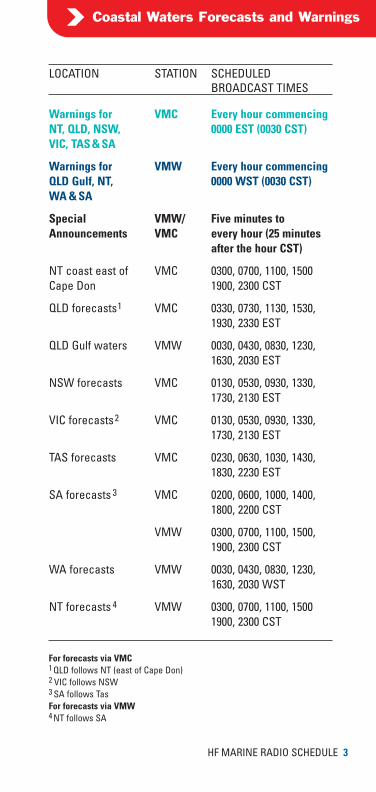
LOCATION STATION SCHEDULED BROADCAST TIMES
Warnings for VMC Every hour commencingNT, QLD, NSW, 0000 EST (0030 CST)VIC, TAS & SA
Warnings for VMW Every hour commencingQLD Gulf, NT, 0000 WST (0030 CST)WA & SA
Special VMW/ Five minutes to Announcements VMC every hour (25 minutes
after the hour CST)
NT coast east of VMC 0300, 0700, 1100, 1500Cape Don 1900, 2300 CST
QLD forecasts1 VMC 0330, 0730, 1130, 1530, 1930, 2330 EST
QLD Gulf waters VMW 0030, 0430, 0830, 1230, 1630, 2030 EST
NSW forecasts VMC 0130, 0530, 0930, 1330, 1730, 2130 EST
VIC forecasts2 VMC 0130, 0530, 0930, 1330, 1730, 2130 EST
TAS forecasts VMC 0230, 0630, 1030, 1430, 1830, 2230 EST
SA forecasts 3 VMC 0200, 0600, 1000, 1400, 1800, 2200 CST
VMW 0300, 0700, 1100, 1500, 1900, 2300 CST
WA forecasts VMW 0030, 0430, 0830, 1230,1630, 2030 WST
NT forecasts 4 VMW 0300, 0700, 1100, 15001900, 2300 CST
HF MARINE RADIO SCHEDULE 3
Coastal Waters Forecasts and Warnings
For forecasts via VMC1 QLD follows NT (east of Cape Don)2 VIC follows NSW3 SA follows TasFor forecasts via VMW4 NT follows SA
MRS_F/A 17/5/04 11:03 AM Page 3

LOCATION STATION SCHEDULED BROADCAST TIMES
Warnings for VMC Every hour commencingNorthern, NE & 0000 EST (0030 CST)SE Areas
Warnings for VMW Every hour commencingNorthern, Western 0000 WST (0030 CST)& SE Areas
Special VMW/ Five minutes to Announcements VMC every hour (25 minutes
after the hour CST)
Northern Area VMC 0000, 0400, 0800, 1200, (NT) 1600, 2000 CST
VMW 0230, 0630, 1030, 1430 1830, 2230 WST
North Eastern Area VMC 0030, 0430, 0830, 1230, (QLD) 1630, 2030 EST
South Eastern Area VMC 0030, 0430, 0830, 1230, (NSW, VIC, TAS& SA) 1630, 2030 EST
VMW 0330, 0730, 1130, 1530, 1930, 2330 WST
Western Area VMW 0230, 0630, 1030, 1430, (WA) 1830, 2230 WST
4 HF MARINE RADIO SCHEDULE
High Seas Forecasts and Warnings
Notes• Validity and issue times for high seas forecasts and-
warnings are in Universal Time Coordinate (UTC).EST is UTC +10 hoursCST is UTC +9.5 hoursWST is UTC +8 hours
• When forecasts and warnings are programmed to bebroadcast at the same time via the same transmitter(VMC or VMW), the order in which they are broadcastwill be the order they are printed in this brochure.
MRS_F/A 17/5/04 11:03 AM Page 4

LOCATIONS†
Mornington Island KowanyamaWeipa Horn Island
LOCATIONS†
Horn Island Marion ReefLockhart River TownsvilleCoconut Island Alva BeachCooktown Hamilton IslandBougainville Reef Creal ReefWillis Island Frederick ReefLow Isles MackayHolmes Reef Gannet CayGreen IsCairnsLihou ReefFlinders Reef
HF MARINE RADIO SCHEDULE 5
Coastal Weather Reports
* These reports are broadcast immediatelyfollowing the forecasts
† Correct at time of print
Queensland Gulf
Queensland North
Broadcast Times* VMC0330, 0730, 1130,1530, 1930, 2330 EST
Broadcast Times* VMC0330, 0730, 1130,1530, 1930, 2330 EST
LOCATIONS†
Yeppoon Double Is PointCato Island Cape MoretonHeron Island Gold Coast SeawayRundle IslandGladstoneLady Elliot IsSandy Cape
Queensland South
Broadcast Times* VMC0330, 0730, 1130,1530, 1930, 2330 EST
Broadcast Times* VMW0030, 0430, 0830,1230, 1630, 2030 EST
MRS_F/A 17/5/04 11:04 AM Page 5
6 HF MARINE RADIO SCHEDULE
Coastal Weather Reports
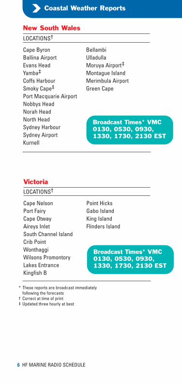
LOCATIONS†
Cape Byron BellambiBallina Airport UlladullaEvans Head Moruya Airport†
Yamba† Montague IslandCoffs Harbour Merimbula AirportSmoky Cape† Green CapePort Macquarie AirportNobbys HeadNorah HeadNorth HeadSydney HarbourSydney AirportKurnell
New South Wales
Broadcast Times* VMC0130, 0530, 0930,1330, 1730, 2130 EST
LOCATIONS†
Cape Nelson Point HicksPort Fairy Gabo IslandCape Otway King IslandAireys Inlet Flinders IslandSouth Channel IslandCrib PointWonthaggiWilsons PromontoryLakes EntranceKingfish B
Victoria
Broadcast Times* VMC0130, 0530, 0930,1330, 1730, 2130 EST
* These reports are broadcast immediatelyfollowing the forecasts
† Correct at time of print† Updated three hourly at best
MRS_F/A 17/5/04 11:04 AM Page 6

HF MARINE RADIO SCHEDULE 7
Coastal Weather Reports
LOCATIONS†
Cape Sorell BichenoCape Bruny Friendly BeachesMaatsuyker Is Tasman IslandLow Rocky Point Cape OtwayMarrawah Wilsons PromontoryCape Grim Gabo IslandKing Is AirportLow HeadFlinders Is AirportSwan IsEddystone PointScamander
Tasmania
Broadcast Times* VMC0230, 0630, 1030,1430, 1830, 2230 EST
LOCATIONS†
Eucla Adelaide AirportNullarbor Victor HarborThevenard Hindmarsh IslandCeduna Cape JaffaColes Point RobePort Lincoln Cape NorthumberlandNeptune IsCape BordaCape du CouedicWarburto PointStenhouse BayWhyallaKingscote AirportEdithburghCape WilloughbyOuter Harbor
South Australia
Broadcast Times* VMC0200, 0600, 1000,1400, 1800, 2200 CST
Broadcast Times* VMW0300, 0700, 1100,1500, 1900, 2300 CST
* These reports are broadcast immediatelyfollowing the forecasts
† Correct at time of print
MRS_F/A 17/5/04 11:04 AM Page 7
Coastal Weather Reports
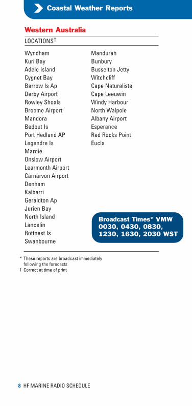
LOCATIONS†
Wyndham MandurahKuri Bay BunburyAdele Island Busselton JettyCygnet Bay WitchcliffBarrow Is Ap Cape NaturalisteDerby Airport Cape LeeuwinRowley Shoals Windy HarbourBroome Airport North WalpoleMandora Albany AirportBedout Is EsperancePort Hedland AP Red Rocks PointLegendre Is EuclaMardieOnslow AirportLearmonth AirportCarnarvon AirportDenhamKalbarriGeraldton ApJurien BayNorth IslandLancelinRottnest IsSwanbourne
Western Australia
Broadcast Times* VMW0030, 0430, 0830,1230, 1630, 2030 WST
8 HF MARINE RADIO SCHEDULE
* These reports are broadcast immediatelyfollowing the forecasts
† Correct at time of print
MRS_F/A 17/5/04 11:04 AM Page 8

HF MARINE RADIO SCHEDULE 9
Coastal Weather Reports
LOCATIONS†
Kuri Bay ManingridaWyndham MilingimbiBrowse Island Elcho IslandTroughton Is Cape WesselNorthern Endeavour Gove AirportPort Keats Northeast IsChannel Point Groote EylandtDum in Mirrie Buoy near 15S 139ECharles Point Centre IslandFish Reef Mornington IsDarwin AirportGunn PointPoint StuartPoint Fawcett
(Bathurst Is)Cape DonMcCluer IsWarruwi
Northern Territory and WesternAustralia East of Kuri Bay
Broadcast Times* VMW0300, 0700, 1100,1500, 1900, 2300 CST
LOCATIONS†
Cape Don Groote EylandtMcCluer Is Buoy near 15S 139EWarruwi Centre IslandManingrida Mornington IsMilingimbiElcho IslandCape WesselGove AirportNortheast Is
Northern TerritoryWaters East of Cape Don
Broadcast Times* VMC0300, 0700, 1100,1500, 1900, 2300 CST
* These reports are broadcast immediatelyfollowing the forecasts
† Correct at time of print
MRS_F/A 17/5/04 11:04 AM Page 9
VMC and VMWVMW VMC
Broadcast Stations
NT
SA
QL
NE
SE
NW
SW
Cape Leeuwin
Mandurah
Jurien Bay
Kalbarri
Carnarvon
NorthwestCape
Cape Preston
Wallal
Kuri Bay
Daly RiverMouth
Cape DonCapeWessel Tor
Bremer Bay
Point Whidbey
Murray Mouth (East)
SA–VIC Border
Darwin
Melbo
Adelaide
Fowlers BayEucla
Israelite BayPerth
WyndhamNT–QLD Border
VMW VM
NORTHERNHIGH SEAS
WESTERNHIGH SEAS
10S
14S
10 HF MARINE RADIO SCHEDULE
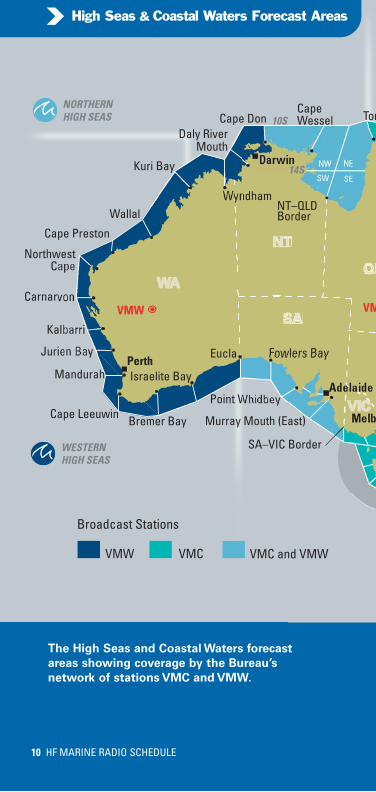
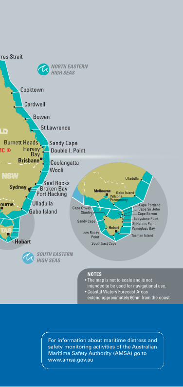
High Seas & Coastal Waters Forecast Areas
The High Seas and Coastal Waters forecast
areas showing coverage by the Bureau’s
network of stations VMC and VMW.
MRS_F/A 17/5/04 11:04 AM Page 10
NSW
LD
rres Strait
Cooktown
Bowen
St Lawrence
Sandy Cape
CoolangattaWooli
Seal RocksBroken Bay
Port Hacking
UlladullaGabo Island
Cardwell
Double I. Point
Hobart
ourne
HerveyBay
Burnett Heads
Sydney
Brisbane
Cape BarrenEddystone Point
St Helens PointSandy Cape
Stanley
Ulladulla
WilsonsPromontory
Melbourne
Hobart
Cape Sir John
Tasman Island
Wineglass BayLow Rocky
Point
South East Cape
Cape Portland
Gabo Island
Cape Otway
MC
NORTH EASTERNHIGH SEAS
SOUTH EASTERNHIGH SEAS
NOTES• The map is not to scale and is not intended to be used for navigational use.• Coastal Waters Forecast Areas extend approximately 60nm from the coast.
For information about maritime distress andsafety monitoring activities of the AustralianMaritime Safety Authority (AMSA) go towww.amsa.gov.au
MRS_F/A 17/5/04 11:04 AM Page 11

Further Information
www.bom.gov.au/marine
www.amsa.gov.au
More information about these services is available from the Bureau’s marine web site.
These services are generated by a computerised system. Every care is taken to ensure all forecasts and warnings are included in the broadcast program. During exceptional weather situations it may not be possible for all coastal weather reports to be transmitted, due to time limitations.
May be directed to the National Marine Services Manager by email: [email protected] or by mailGPO Box 1289KMelbourne VIC 3001
Enquiries
To contact the Maritime Safety Agency in your State or Territory go to the Australian Maritime Safety Authority (AMSA) web site.
Other Maritime Safety Communications
HF Radio Schedule
A SERVICE TO MARINERS FROM THE
BUREAU OF METEOROLOGY
Marine Weather
SERVICES VIA VOICE
© Commonwealth of Australia, May 2004