marine hydrogeology: future prospects for major...
TRANSCRIPT

Fisher, Marine Hydrogeology Initial Submission March 2004, Page 1
Marine Hydrogeology: Future Prospects for Major Advances
A. T. Fisher, Earth Sciences Department and Institute for Geophysics and Planetary Physics,
University of California, Santa Cruz, CA 95064
Abstract
Marine hydrogeology is a broad-ranging scientific discipline involving the exploration of
fluid-rock interactions below the seafloor. Studies have been conducted at seafloor spreading
centers, mid-plate locations, and in plate- and continental-margin environments. Although many
seafloor locations are remote, there are aspects of marine systems that make them uniquely
suited for hydrologic analysis. Newly-developed tools and techniques, and the establishment of
several multidisciplinary programs for oceanographic exploration, have helped to push marine
hydrogeology forward over the last several decades. Most marine hydrogeologic work has
focused on measurement or estimation of hydrogeologic properties within the shallow
subsurface, but additional work has emphasized measurements of local and global fluxes, fluid
source and sink terms, and quantitative links between hydrogeologic, chemical, tectonic,
biological, and geophysical processes. In addition to summarizing selected results from a small
number of case studies, this paper includes a description of several new experiments and
programs that will provide outstanding opportunities to address fundamental hydrogeologic
questions within the seafloor during the next 20-30 years.
I. Introduction
Marine hydrogeology is the study of fluid-rock interaction below the seafloor (Figure 1).
Processes of interest include: vigorous fluid circulation resulting from heating (both lithospheric

Fisher, Marine Hydrogeology Initial Submission March 2004, Page 2
and magmatic), alteration of the oceanic lithosphere and the chemistry of flowing fluids as a
result of water-rock reactions; establishment and maintenance of subseafloor microbial
ecosystems; diagenetic, seismic, and magmatic impacts resulting form fluid flow along plate-
boundary faults; creation of ore and hydrate deposits both on and below the seafloor; and
exchange of fluids and solutes across continental margins, influencing the extent and quality of
near-shore water and biological resources.
Parameters of interest to seafloor hydrogeologists include: fluxes of fluid, heat, and
solutes; the magnitude and dynamic behavior of driving forces; the nature of source and sink
terms; storage properties; and relations among these parameters and between fundamental
properties and the processes listed above. Hydrogeologic systems are present below the
subseafloor worldwide, from seafloor spreading centers where new tectonic plates are created, to
mid-plate regions where seamounts provide high-permeability connections between the
lithosphere and the overlying ocean, to subduction zones where older plates plunge into the
asthenosphere to be recycled, to continental margins where enormous lateral gradients drive fluid
between terrestrial and marine reservoirs. Although many of these regions, features, and
properties have drawn the attention of individual researchers for the last several decades, there is
growing appreciation that marine hydrogeology comprises a distinct, fundamentally important
Earth Science discipline. Marine hydrogeology has global implications; we cannot claim to
understand our planet’s ground water systems if we ignore the two-thirds of them that lie below
the seafloor.
There are two primary messages I hope to convey in this paper. First, this is a very
exciting time for marine hydrogeologic studies, when newly-available data, observational tools
and techniques, conceptual and quantitative models, access to remote environments, and a
Fisher, Marine Hydrogeology Initial Submission March 2004, Page 3
willingness to embrace multidisciplinary approaches leave us poised to make major advances.
There are going to be especially good opportunities for marine research elucidating links
between hydrogeologic, tectonic, magmatic, and biological processes during the next 20-30
years.
Second, numerous hydrogeologic topics important to those working in a wide range of
environments should be addressed within the seafloor. These topics include: strategies for
developing continuum-modeling approximations for heterogeneous (often, fractured), strongly-
anisotropic aquifers; incorporation of complex and uncertain geological information into
conceptual and quantitative models of coupled flows; and the apparent scaling of hydrogeologic
phenomena.
Because space is limited, and several recently- and soon-to-be-published review articles
and books (cited throughout this paper) cover these topics in considerable detail, I focus on a
small number of studies and use these examples to suggest where marine hydrogeology appears
to be headed. I begin with a brief overview of tools and methods and a summary of basic
research goals, then consider work that has focused on two main classes of marine
hydrogeological environments: those within igneous rock (at spreading centers and in mid-plate
locations), and those within sedimentary environments (along continental and plate margins).
II. Marine Hydrogeologic Tools and Methods
Multibeam swath-mapping systems, which became widely available to marine geologists
in the 1980’s, have revolutionized the study of seafloor and subseafloor hydrogeologic
environments. These tools, including banks of transmit and receive transducers that are hull-
mounted or towed behind research platforms, allow rapid collection of high-quality topographic

Fisher, Marine Hydrogeology Initial Submission March 2004, Page 4
and back-scatter data, typically at speeds of 0.5-10 kts. The data produced during these surveys
vary in swath width from a few hundred meters to a few kilometers, depending on water depth,
transducer depth, and resolution requirements. Many Earth scientists (and the public at large) are
surprised to learn that we have more detailed maps of the Moon, Mars, and other objects in our
solar system than we do for most of the seafloor. Our ocean is vast, covering >2/3 of the Earth’s
surface, and much of it is remote or commonly experiences sea conditions that make mapping
difficult. In addition, typical survey speeds and expedition length restrictions (generally ≤30-50
days), limit how much area can be covered during a single voyage. Most effort has focused in the
last 20 years on plate- and continental-margin environments. Seafloor topographic maps based
on a pixel size ≤150 m on a side exist for less than 10% of the seafloor; maps with a resolution
equivalent to the standard USGS 7.5-minute quad exist for less than 1% of the seafloor. Global
seafloor topographic maps have been created using satellite gravimetry and along-track depth
data from ships, but mean resolution is on the order of ~3 km [Smith and Sandwell, 1997].
Imaging the geologic environment below the seafloor is accomplished mainly by seismic
methods, primarily seismic refraction, which yields vertical profiles of geophysical structure.
Seismic surveys are commonly designed to comprise grids of intersecting profiles; if these
surveys include a dense enough set of parallel and crossing lines, processing in three dimensions
can result in a much more detailed and accurate view of subseafloor conditions. Such surveys are
particularly valuable in locations where geological structures are complex, non-horizontal, or
involve subtle differences in rock properties, but they are also time-consuming, expensive, and
computationally challenging. Tomographic techniques have been applied to several seafloor
settings, particularly across seafloor spreading centers. Several of these studies have led to

Fisher, Marine Hydrogeology Initial Submission March 2004, Page 5
assessments of the thermal state of the lithosphere, which is strongly influenced by the fluxes and
flow paths of circulating fluids [e.g., Cherkaoui et al., 2004; Dunn and Toomey, 2001].
The Deep Sea Drilling Project (DSDP) was developed through the Joint Oceanographic
Institutions for Deep Earth Sampling (JOIDES) and operated a customized drilling research
vessel during 1968-83. The DR/V GLOMAR Challenger used a dynamic “thruster” system to
hold the platform on station, could operate in water up to 7 km deep, and penetrate another 2 km
below the seafloor. Although the scope of DSDP research was necessarily broad, and focused
initially on topics such as testing the theory of plate tectonics, later expeditions included
investigations of fluid flow in oceanic sediments and rocks (mainly within young igneous crust
and near subduction zones). The DSDP set a standard for international cooperation in
multidisciplinary Earth Science projects, forging partnerships with numerous countries,
completing 96 expeditions and thousands of drill holes.
The DSDP ended in 1983 and was succeeded by the Ocean Drilling Program (ODP),
which leased and modified another platform, DR/V JOIDES Resolution. ODP at-sea operations
ran during 1985-03, extending scientific drilling to higher latitudes, more remote areas, and
greater water and subseafloor depths. By the end of ODP operations, more than 20 nations had
contributed to operational costs and staffing of science parties. ODP greatly extended studies of
marine hydrogeology begun during DSDP, particularly with in-situ measurements and
experiments and the establishment of long-term seafloor observatories.
Hydrogeologists working on land have conducted aquifer tests for more than a century,
but tests were not attempted in deep seafloor boreholes until the latter part of DSDP [Zoback and
Anderson, 1983], and methods were substantially improved during ODP [Becker, 1986; Becker
and Davis, 2004]. Borehole packer tests in the seafloor have been relatively short in terms of
Fisher, Marine Hydrogeology Initial Submission March 2004, Page 6
pumping time, have virtually all been restricted to single-hole experiments (testing only the near-
borehole region), and have not been particularly effective at delineating the distribution of
hydrologic activity. The development over the last fifteen years of pressure-tight, subseafloor
observatories (“CORKs”) comprises a major advance in marine hydrogeologic studies [Davis
and Becker, 2002b; Davis et al., 1992a]. These systems allow thermal, pressure, and chemical
disturbances associated with drilling to dissipate, and provide monitoring and sampling points
for subsequent experiments. CORK systems have been used in the past mainly for passive
monitoring and sampling in single holes, but there are future plans to use these systems for
controlled, cross-hole testing.
Our understanding of marine hydrogeologic processes has benefited greatly from the use
of several indirect (proxy) tools to estimate flow rates and directions. Perhaps the most important
of these is subseafloor heat flow measurements [e.g., Fisher et al., 2001; Langseth and Herman,
1981; Williams and Von Herzen, 1974]. The use of heat flow to estimate fluid fluxes, either on a
regional or global basis, starts with calculation of the conductive lithospheric heat flow, based on
well-established models for plate evolution [e.g., Parsons and Sclater, 1977; Stein and Stein,
1992]. Conductive lithospheric cooling curves are compared to data sets of observations, and
differences between the two is often attributed to advective heat extraction. It may seem
surprising that (a) such an indirect approach is necessary, and (b) that measurements of seafloor
heat flow are sufficiently accurate for this purpose. The indirect approach is needed because the
heat capacity of seawater is very high, and the ocean is essentially an infinite heat sink, so direct
detection of fluid outflow is generally not possible. The vast majority of seafloor fluid flow
occurs in areas that are far from volcanic heat sources (Fig. 2), and the temperature differences
between most subseafloor fluids and bottom water tend to be very small. Even a few tens of

Fisher, Marine Hydrogeology Initial Submission March 2004, Page 7
meters above high-temperature (≥350°C) hydrothermal vents, the water column thermal anomaly
is generally small, on the order of a few tens of mK [e.g., Baker and Massoth, 1987; Murton et
al., 1999] and the ocean is vast.
Methods to determine subseafloor temperatures and thermal gradients in shallow marine
sediments have become increasing sophisticated, and mK resolution is now routine. The high
heat capacity of water, which makes direct measurement of fluid outflow difficult, also makes
detection of subseafloor flows and seafloor seepage possible using heat flow measurements,
often co-located on high-quality seismic data [e.g., Davis et al., 1989; Fisher, 2003b]. In
addition, numerous thermal logs in open boreholes have been used to estimate rates of flow to or
from the formation [e.g., Becker et al., 1985]. These are perturbation experiments, since the
ambient formation fluid (and its associated properties and pressure) is replaced by cold seawater
(the primary drilling fluid used during DSDP and ODP), leading to long-term flow to or from the
formation, depending on the magnitude and sign of the pressure differential. Thermal logs can
also be helpful in delineating relatively narrow regions within which fluid flows; in combination
with packer tests and geophysical logs (density, formation microscanner, resistivity), thermal
data can provide detailed hydrogeologic insight.
Measurements of subseafloor pore-fluid chemical data can also help to identify regions
within which fluid flow may be occurring. The challenge is to select naturally-occurring tracers
that are conservative, or reactive in ways that are well understood, and to collect uncontaminated
samples at sufficient resolution. Geochemical data have been used in both hard rock and soft
rock seafloor settings to identify likely fluid pathways [e.g., Baker et al., 1991; Bekins et al.,
1994; Gieskes et al., 1990; Kastner, 1982; Mottl et al., 1994]. Collection of pristine pore fluids
from unconsolidated sediments is fairly routine, at least within layers that are not extremely
Fisher, Marine Hydrogeology Initial Submission March 2004, Page 8
sandy, but there continue to be serious challenges in extracting uncontaminated fluids from hard
rock, where the most important hydrogeologic conduits are likely to be regions that are not
represented by core. Similarly, it is difficult to recover pristine formation fluids from open
boreholes. The drilling process causes considerable invasion of the formation surrounding a
borehole by drilling fluid (typically surface seawater), and the most permeable regions are likely
to be the most contaminated. If the drilling fluid is denser than formation fluid, a common
occurrence in many settings, “run away” invasion can be initiated during drilling and the
borehole may not recover for many years [e.g., Becker et al., 1983; Gable et al., 1989; Guerin et
al., 1996]. In the petroleum industry and in many applications of environmental hydrogeology on
land, holes are produced or purged for considerable time prior to collection of chemically-useful
samples. This approach is not practical within most open boreholes on the seafloor, but the
recent development of CORK observatories has profoundly improved opportunities for
collection of pristine fluid samples. Geochemists also sample pore fluids in sediment close to
uppermost basement and in areas of upward fluid seepage, to get estimates of basement fluid
compositions.
Both thermal and chemical data from shallow subseafloor depths can be used to estimate
subvertical seepage rates [Langseth et al., 1988; Wheat, 1990], with chemical data being about
three orders of magnitude more sensitive to seepage [Fisher, 2003b; Wheat et al., 2004b]. In
addition, seepage meters developed for work in the shallow and deep ocean [Suess et al., 1999;
Taniguchi et al., 2003; Tryon et al., 2001] allow direct measurements of local seepage rates at
the seafloor, demonstrating the importance of flow heterogeneity and transience.
III. Seafloor Hydrogeology: Goals, Accomplishments, and Future Opportunities

Fisher, Marine Hydrogeology Initial Submission March 2004, Page 9
Marine hydrogeologic studies focus on four main topics: (1) hydrogeologic properties
(transmissive and storage) and the nature of flow paths, (2) driving forces, (3) fluxes, and (4)
sources and sinks. The first topics are perhaps the most fundamental, since they address the basic
physics of flow phenomena, and help us to determine how the parameters that we can readily
measure lead to the processes we care most about (Fig. 3).
The first set of topics is readily addressed with measurements on the seafloor and in
boreholes [e.g., Carson and Screaton, 1998; Davis et al., 2000; Fisher, 1998], although there are
considerable difficulties related to the transient nature of flow processes, heterogeneity, scaling,
anisotropy, and coupling between heat, fluid, chemical and biological systems. The second and
third topics have also received considerable attention in the last several decades, but the
techniques and interpretive methods remain more developmental [e.g., Baker et al., 1996; Davis
and Becker, 2002a; Elderfield et al., 1999]. The fourth topic has been addressed mainly through
computer modeling, since rates of fluid production and uptake often occur over geological
timescales [e.g., Bekins et al., 1994]. The summary and case studies that follow focus mainly on
measurements related to hydrogeologic properties and flow paths, and to a lesser extent, driving
forces, fluxes, fluid sources, and the relations between these parameters.
As summarized by Ingebritsen and Sanford [2004], some aspects of marine systems are
fundamentally different from equivalent systems on land, and other aspects are remarkably
similar. Most groundwater systems on land can be analyzed by consideration of differences in
total head assuming constant fluid density. In contrast, practically all marine hydrogeologic
studies require consideration of fluid density, particularly because permeabilities are often very
high and driving forces are surprisingly small. Within these systems, a gradient in potential will
coincide with the gradient in fluid flow only if both [Hickey, 1989; Hubbert, 1956; Oberlander,
Fisher, Marine Hydrogeology Initial Submission March 2004, Page 10
1989]: (1) permeability is either homogeneous or is anisotropic with the dominant flow direction
coinciding with the steepest gradient, and (2) variations in fluid density occur only in the vertical
direction, and surfaces of equal density correspond to surfaces of equal pressure. Neither of these
conditions is likely to be met in most seafloor systems, so fully-coupled solutions (heat-fluid,
solute-fluid) are generally required even to assess primary flow directions and rates. In addition,
static and steady-state analyses can be misleading in many cases; dynamic, transient models are
often required.
Within terrestrial hydrogeologic systems, the shallowest rocks tend to be the most
permeable, and permeability tends to decrease with depth below the land surface. This trend is
broadly consistent with seafloor basement rocks, but most marine sediments have permeabilities
that are 3-7 orders of magnitude lower than those of shallow basement rocks [e.g., Becker and
Davis, 2003; Bryant et al., 1974; Davis et al., 1997; Fisher et al., 1994; Spinelli et al., 2004].
One of the most ubiquitous causes for lateral variations in head on land is topography, with many
elevated regions hosting sites of recharge and relatively high water table levels. In contrast, the
seafloor is nominally a hydrostatic boundary, with three extra complexities. First, variations in
pressure, temperature, and salinity yield differences in seawater density on the order of 1-2%
over a depth range of 0-4 km (a typical depth of the abyssal seafloor). In addition, seafloor
aquifers experience considerable high-frequency variations in pressure at the upper boundary as
a result of ocean tides and other processes. Finally, topographic and basement highs in the
seafloor can lead to conductive refraction of lithospheric heat flow, resulting in significant lateral
temperature, density, and pressure gradients.
The deep seafloor is essentially a constant-temperature boundary, at least on a local-to-
regional basis, with the ocean holding temperatures steady at –1 to 2°C. There can be large local
Fisher, Marine Hydrogeology Initial Submission March 2004, Page 11
differences in bottom water temperatures in shallow marine settings. Phase separation and
segregation are important processes in geothermal areas on land and in the seafloor as well, and
the presence of varying amounts of salt in subseafloor fluids fundamentally changes phase
relations and can lead to very complex patterns of flow [e.g., Bischoff and Rosenbauer, 1989].
Despite these complexities, there are many advantages in studying hydrogeology in the
seafloor. The first-order boundary conditions (relatively constant pressure and temperature) are
relatively simple compared to those that often must be applied to crustal-scale systems on land.
Because of limited anthropogenic influences, the signal-noise ratio for monitoring conditions
within the seafloor can be very high, particularly in mid-plate areas. The ocean also has a
remarkably consistent solute chemistry. Thus for many geochemical and thermal studies,
hydrogeologists can track extremely subtle changes in water composition and temperature as
they occur below the seafloor. The seafloor is geologically active in many settings, generating
large, natural perturbations that occur frequently on human time-scales.
The upper oceanic (mostly basaltic) crust comprises the largest continuous aquifer on
Earth, permitting hydrogeologists to assess processes and properties over enormous lateral scales
(at least tens of kilometers). In many systems on land, changes in basic rock types and modes of
emplacement greatly limit lateral continuity. Marine seismic surveys allow first-order,
subsurface features to be mapped in considerable detail, on a continuous basis, along regularly-
spaced grids of lines. Running similar surveys on land is very difficult because of topography
and urbanization, and data quality is often less that of conventional high-resolution, seafloor
surveys. The introduction of differential-GPS and dynamic positioning on many research vessels
allows scientists to return to particular locations of interest with 5-10 m positioning confidence,
and submersibles, remotely operated vehicles, camera sleds, and other seafloor tools allow
Fisher, Marine Hydrogeology Initial Submission March 2004, Page 12
detailed investigation of small features. Finally, it is generally not necessary to secure discharge
or injection permits for subseafloor aquifer testing, since the fluids pumped typically have a
chemistry very close to that of seawater. This means that very long-term (multiyear) testing in
the seafloor is possible. Much of the seafloor is considered to be “international waters” and is
readily accessible, although permission must be secured to work in territorial waters of other
countries (a task routinely completed by ship operators with the assistance of scientific
investigators and the U. S. Department of State).
A. Studies of Seafloor Basement Hydrogeology
There are many kinds of geological, geophysical, and geochemical studies that have
important implications for the hydrogeology of oceanic crust, including studies of seismicity
[Golden et al., 2003; Johnson et al., 2000a; Wilcock et al., 2002], the distribution of diffuse
versus focused flow at spreading centers [Converse et al., 1980; Schultz et al., 1992], relations
between venting, magmatism, and crustal structure [e.g., Baker et al., 1989; Haymon, 1996;
Haymon et al., 1991; Kelley et al., 2001a], and the distribution of subseafloor ecosystems
[Cowen et al., 2003; Kelley, 2002]. Space limitations preclude discussion of these and many
related topics, but the interested reader is directed to several excellent compilations and reviews,
and references cited therein [e.g., Cary et al., 2004; Davis and Elderfield, 2004; Halbach et al.,
2003; Humphris et al., 1995].
1. Global considerations
Fisher [2003a; 2003b; 1998], Becker and Davis [2004], and Davis and Becker [2004]
summarize studies of seafloor basement hydrogeology over the last 30 years, with an emphasis

Fisher, Marine Hydrogeology Initial Submission March 2004, Page 13
on work occurring on ridge flanks, many kilometers or more from seafloor spreading centers.
Mottl [2003] and Johnson and Pruis [2003] synthesize and update studies completed over the last
several decades in which global hydrothermal heat and mass fluxes were estimated on the basis
of thermal and chemical anomalies.
Mature oceanic crust is generally 6–7 km thick and is highly layered. In early studies,
seismic velocities and structure were used to infer basic crustal composition and mode of
emplacement, and models were confirmed and refined through sampling and analysis of rocks
from the seafloor and ophiolites [e.g., Houtz and Ewing, 1976; Moores and Vine, 1971]. From
the top-down, the ocean crust comprises sediments of various kinds, extrusive basalt (pillows,
flows, breccia) and intrusive basalt (sheeted dikes), underlain by gabbro. The Moho separates
these rocks from peridotitic mantle rocks. Although alteration patterns in seafloor boreholes and
ophiolites indicate that water-rock interaction is pervasive, it is also highly heterogeneous and
(on average) decreases in extent with depth below the seafloor [Alt et al., 1998; Gillis and
Robinson, 1988]. Exceptions to these depth-dependent alteration trends occur in mainly in
magmatically-active areas such as seafloor spreading centers, where elevated permeability
channels likely penetrate to significant (perhaps mantle) depths.
The upper few kilometers of crust formed at slow- to fast- spreading ridges (half-
spreading rate of ~10 to 60 mm/yr, respectively) is nominally similar in gross structure, but
primary emplacement and modification processes differ significantly as a function of spreading
rate [e.g., Karson, 2002; Mutter and Karson, 1992; Sinha et al., 1998]. It was shown recently
that ultra-slow spreading seafloor (<5 mm/yr) has a profoundly different crustal structure, with a
broad, diffuse region of crustal construction, and rocks commonly associated with the deep crust
and upper mantle exposed at the seafloor [Dick et al., 2003]. Several studies have also suggested

Fisher, Marine Hydrogeology Initial Submission March 2004, Page 14
that there is an influence of the rate of crustal accretion and mode of modification on the extent
and nature of water-rock interactions [e.g., Bach and Humphris, 1999; Fisher et al., 2003b;
Kelley et al., 2001b], but quantifying specific causal relations will require additional work.
The global oceanic crustal fluid reservoir has a mass comparable to that of water in ice
caps and glaciers [Johnson and Pruis, 2003]. Although often considered a peripheral component
of the hydrological cycle, seafloor hydrothermal circulation is likely to result in a global mass
flux that is comparable to that of rivers [Mottl, 2003]. This flux is sufficiently large, ~0.2-2 x 10⁴
km3/yr, that the entire volume of the global ocean is recycled through the seafloor about every
100-500 kyr. In fact, this global estimate is likely to be an extreme lower limit on actual
hydrothermal fluxes for several reasons. First, observations demonstrate that circulation within
oceanic crust often continues well beyond the average 65 Ma age, when the heat flow anomaly
disappears [e.g., Noel and Hounslow, 1988; Von Herzen, 2004] (Fig. 2). This flow may not
extract much lithospheric heat, but it certainly has important chemical and biological
implications. In addition, thousands of basaltic seamounts are likely to induce a global flux
comparable to that through ridge flanks and spreading centers [Harris et al., 2004].
Most seafloor hydrothermal circulation occurs far from volcanically-active areas, where
the primary driving force is buoyancy that results from heating at the base of the crust. Because
most of this circulation occurs at low temperatures, detection is theoretically easiest in areas
close to recharge sites where thermal suppression is greatest [e.g., Langseth and Herman, 1981].
Unfortunately, recharge often occurs where bare rock is exposed at the seafloor, and thermal
measurements at these sites are difficult. In some cases, one can sample pore fluids at the base of
thin sediment layers close to sites of recharge, but these tend to look very similar (or identical) to
regional bottom water. As in hydrogeologic systems on land, quantification of recharge
Fisher, Marine Hydrogeology Initial Submission March 2004, Page 15
processes has been and continues to be a great challenge.
2. Basement permeability
Borehole studies have provided critical information concerning permeability in the
oceanic crust. A compilation of (single-hole) packer and thermal (flow rate) experiments
illustrate several notable trends (Fig. 4). First, although tests in a wide variety of basement ages
have indicated a wide range of permeabilities, the data are remarkably consistent
within the measured depth intervals. The greatest permeabilities appear to be restricted to the
upper few hundred meters of the seafloor and tend to be concentrated within intervals having a
thickness on the order of tens of meters. When one tests smaller depth intervals, one finds higher
absolute permeabilities. These results are very consistent with similar studies conducted within
heterogeneous, particularly fractured, rock aquifers on land [e.g., Manning and Ingebritsen,
1999; Paillet et al., 1986]. It is also interesting that the greatest bulk permeabilities are on the
order of 10-10 to 10-9 m2; these high values allow enormous fluxes with very small driving forces,
and provide unique opportunities and challenges for direct observations of fluid flow.
Another important trend emerges when these data are plotted as a function of seafloor age
(Fig. 5). Despite extreme differences in rates of crustal production and tectonic setting, the global
observational data set of subseafloor measurements suggests that there is a consistent evolution
of permeability within uppermost ocean basement [Becker and Davis, 2003; Becker and Fisher,
2000; Fisher and Becker, 2000]. The highest values are found generally within the youngest
seafloor, and values decrease rapidly during the first few million years (Fig. 5A). Site 858 in
Middle Valley, a sedimented spreading center at the northern end of the Juan de Fuca Ridge,
yielded apparent permeability values that are anomalously low for the age of the seafloor (<0.2

Fisher, Marine Hydrogeology Initial Submission March 2004, Page 16
Ma), but these measurements were made in a recently-buried volcanic edifice [Langseth and
Becker, 1994]. Boreholes in many sites younger than 8 Ma have been tested both with a drill-
string packer and by using thermal (flow-meter) logs. In general, the flow-meter data suggest
permeabilities about 0.5-1.0 orders of magnitude greater than those estimated with the packer,
consistent with the flow-meter experiments testing a larger crustal region than packer
experiments [Fisher, 1998]. There is a general progression in the magnitude of apparent
permeabilities from these tests as a function of measurement scale, with the lowest values
resulting from very short (20-40 minute) slug tests, and the highest values resulting from
modeling and interpretations of tidal and seismic responses in sealed boreholes [Fig. 5B, Becker
and Davis, 2003; Davis et al., 1999; Davis et al., 2000; Davis et al., 2001; Fisher, 1998; Stein
and Fisher, 2003].
Fisher and Becker [2000] analyzed the global seafloor heat flow dataset and argued that
effective upper basement permeabilities must be considerably greater than those measured in
single boreholes, given available driving forces, in order for sufficient fluid and heat fluxes to
occur within ridge-flank hydrothermal systems (Fig. 2). The magnitude of permeabilities
required by this analysis is consistent with packer and flow-meter data collected within young
ridge-flank sites (out to ~4 Ma in age; Fig. 5A). But the global analysis predicts that the
reduction in effective permeability with age beyond this time should occur relatively slowly,
whereas the experimental dataset suggests a more rapid reduction. A rapid reduction in
permeability is more consistent with upper crustal seismic and bulk density data [e.g., Carlson,
1998; Fisher and Becker, 2000; Johnson et al., 2000b]. However, hydrothermal circulation
occurs within those parts of the oceanic crust that do not transmit seismic waves particularly
efficiently, loose breccia and gaps between more massive units, and it is the largest and most

Fisher, Marine Hydrogeology Initial Submission March 2004, Page 17
continuous pore spaces that transmit most fluid, not the small cracks that fill rapidly as the crust
evolves.
The observation that apparent permeabilities vary with measurement scale is consistent
with studies in other hydrogeologic systems [Fig. 5B., Brace, 1980; Clauser, 1992; Neuman and
Di Federico, 2003; Renshaw, 1998; Rovey and Cherkauser, 1995; Schulze-Makuch and
Cherkauer, 1997], but with some important differences. The global dataset of fractured rock
permeabilities suggests a scaling effect that increases until reaching a modest measurement scale
of perhaps 10-100 m, with permeabilities leveling off or even dropping after that scale. In
contrast, the seafloor basement data suggest that scaling may continue to significantly greater
length scales. Actually the seafloor data set appears to overlap other data sets in fractured rocks,
bridging the gap between crystalline and fractured sedimentary systems (Fig. 5B).
C. Basement case studies
Drilling, sampling, and hydrogeologic testing within an active seafloor spreading center
has been a long-standing goal of scientific ocean drilling, but most attempts have been frustrated
by he difficulty in establishing and deepening a stable hole. Considerable technical effort has
yielded several promising approaches for bare-rock work, but the greatest successes in ridge-
crest drilling have been on sedimented ridges and within ore deposits [Binns et al., 2002; Davis
et al., 1992b; Fouquet et al., 1998; Herzig et al., 1988]. Both kinds of sites have produced
stunning rock and fluid samples, and sedimented ridges allowed the first hydrogeologic testing in
the near-ridge environment.
Sedimented-ridges occur where the rate of magmatic emplacement is insufficient, relative
to that of sedimentation, to allow basalt extrusion onto the seafloor. Instead, basaltic magma rises

Fisher, Marine Hydrogeology Initial Submission March 2004, Page 18
from depth and spreads laterally below the seafloor, forming an interlayered sediment-sill
complex. The low-permeability sediments capping these systems limits the exchange of fluids,
heat and solutes between the crust and overlying ocean, allowing unique opportunities to drill,
core, sample, and test very young seafloor.
Two ODP legs worked in Middle Valley, a sedimented rift at the northern end of the Juan
de Fuca Ridge (Fig. 6). Two holes were cased and sealed in Middle Valley during ODP Leg 139,
establishing the first long-term CORK observatories [Davis et al., 1992a]. Hole 858G was drilled
in the Dead Dog vent field, within a few tens of meters of several clusters of active chimneys
discharging fluids at temperatures up to 280 °C. Dead Dog vent field is located within a well-
defined area of high acoustic back-scatter, covering an area of 0.3 km2. The hole penetrated 260
m of sediment and 175 m of basaltic basement, interpreted to be a buried volcanic edifice. Hole
857D was drilled 1.6 km to the south, through 470 m of sediments and 500 m of alternating
sediments and sills, with this deeper section thought to comprise the primary hydrothermal
reservoir. Geophysical and flow-meter logs and packer experiments were completed [Becker et
al., 1994; Langseth and Becker, 1994], and both holes were sealed with CORK observatories
(including thermistor chains, fluid samplers, and pressure gauges) and left to equilibrate. The
observatories were visited and serviced by submersibles and remotely-operated vehicles over
several years, and subsequently during ODP Leg 169.
Pressure records downloaded from the observatories after 14 months [Davis and Becker,
1998] suggested that basement fluids in Hole 858G were overpressured relative to seafloor
hydrostatic conditions by 180 kPa, whereas fluid pressures in Hole 857D were underpressured by
400 kPa. This pattern makes some sense, since basement fluids in an area of active venting
should be overpressured, and the fluids within the reservoir need to be underpressured in order to
Fisher, Marine Hydrogeology Initial Submission March 2004, Page 19
draw recharge. But this distribution of under- and overpressures also seemed to suggest that
fluids within basement should flow away from the vent field at depth and into the surrounding
crust. In fact, the in-situ gradient in the fluid impelling force is from the broader reservoir (Hole
857D) towards the vent field (Hole 858G), as determined by correcting the seafloor pressures
measured at the observatories for differences in fluid temperature and density with depth [Fig.
6C, Stein and Fisher, 2001]. Based on the interpretation that vigorously-convecting fluids at
depth are isothermal at 280°C [Davis and Fisher, 1994; Davis and Villinger, 1992], the
temperature-corrected difference in head between the two sites is only 1.7 m. This remarkably
small head difference between sites 1.6 km apart, across considerable basement relief that is
essentially isothermal, requires that hydrothermal basement is extremely permeable.
An estimate of large-scale basement permeability was made for this region based on
application of a simple model for aquifer response to pumping [Theim, 1906]. Holes 858G and
857D are considered to be observation wells located 50 m and 1600 m, respectively, from the
vent field, idealized as a single large “pumping well.” Based on the temperature-corrected head
difference between the observation points, and a reservoir thickness of 10-1000 m, the bulk
permeability in basement necessary to supply fluid to the vents is 10-12 to 10-10 m2, with the
higher permeability value corresponding to the thinner aquifer (Fig. 6D). A value of 10-10 m2 was
also estimated for a 5 to 10-m-thick interval based on packer and flow-meter experiments [Fig. 4,
Becker et al., 1994].
Considerable hydrogeologic work has also been completed along the eastern flank of the
Juan de Fuca ridge, a well-studied off-axis region hosting several distinct hydrothermal systems
(Fig. 7). Basement topographic relief in this area produced barriers to turbidites that flowed from
the nearby continental margin, resulting in the accumulation of thick sediments on young

Fisher, Marine Hydrogeology Initial Submission March 2004, Page 20
seafloor. Oceanic basement is exposed to the west, near the spreading center, and the sedimented
seafloor is relatively flat to the east, except over widely-spaced seamounts.
ODP Leg 168 completed work along a transect of ten sites in this area, on 0.9 to 3.6 Ma
seafloor. Four sites were instrumented with CORK observatories and have been revisited several
times to service instruments, collect fluid and biological samples, and download pressure and
temperature data [Cowen et al., 2003; Davis and Becker, 1998; Davis and Becker, 2004; Davis et
al., 2000; Wheat et al., 2004a]. These observatories have yielded rich data sets demonstrating the
dynamics of fluid processes within an oceanic ridge flank. At the eastern end of the drilling
transect, two observatories were installed 2.2 km apart, into a buried basement ridge-trough pair
(Fig. 7). The buried ridge observatory, at Site 1026, penetrated 250 m of sediment and 20 m of
uppermost basement, whereas the buried trough CORK, at Site 1027, penetrated 600 m of
sediment and 40 m of basement. Under purely conductive conditions, upper basement
temperatures at Site 1027 would have been about 40 °C warmer than those at Site 1026, but in-
situ temperature measurements indicate that uppermost basement at these sites is practically
isothermal. This condition requires vigorous fluid convection in basement, and the relatively
small pressure gradients detected between the two CORKs suggests that effectively basement
permeability must be very high [Davis and Becker, 2002a; Davis et al., 1989; Davis et al., 1997;
Spinelli and Fisher, 2004].
These observatories have been used to estimate hydrologic properties on the basis of
responses to tidal loading [Davis and Becker, 2004; Davis et al., 2000; Wang and Davis, 1996],
generating permeability estimates for the upper oceanic crust on the order of 10-10 to 10-9 m2. The
observatories have also recorded transient fluid pressure “events” associated with seismic
activity more than 100 km from the instruments. earthquake epicenters respond to seismic events

Fisher, Marine Hydrogeology Initial Submission March 2004, Page 21
[Davis et al., 2001]. After filtering CORK pressure records to remove the influence of
barometric pressure changes and tides, distinct signals remain that correlate with independently-
detected seismic events along plate-boundary faults. An October 1996 event along the Nootka
Transform Fault led to an abrupt decrease in fluid pressure at Site 1027, followed by a gradual
rise back to background values (Fig. 7B). A June 1999 event near the spreading axis of the Juan
de Fuca Ridge lead to an abrupt rise in fluid pressure at Site 1024, followed by a slow decay of
the pressure perturbation (Fig. 7C). This last observation is interpreted to have been associated
with an episode of seafloor spreading along the ridge crest 20 km to the west. The stresses
associated with spreading events are thought to be transmitted through crustal rocks, and the
gradual decay of pressure depends on the hydrologic properties of the upper crust [Davis et al.,
2001].
Hydrogeologic models have played a fundamental role in interpretation of pressure,
temperature, and geochemical data from ridge flanks, but it has been challenging to reconcile
results based on different observations, and to select preferred solutions generated by different
models. For example, Elderfield et al. [1999] used observations of pore fluid chlorinity, sulfate,
and 14C age to estimate rates of lateral fluid flow along the western end of the ODP Leg 168
transect. Pore fluids were collected from sediments just above basement, and assumed to be in
equilibrium with underlying basement fluids. Based on the spacing between sites and a plug-flow
model for solute transport, lateral fluid flow velocities in upper basement were estimated to be
~2 m/yr, with net transport from west to east, a direction consistent with seafloor heat flow data
[Davis et al., 1999]. Assuming an effective porosity in the upper basement aquifer 1-10%, lateral
specific discharge flux would be 0.02 – 0.2 m/yr. Stein and Fisher [2003] investigated this
hydrogeologic system using pressure and thermal observations and a coupled model of fluid and

Fisher, Marine Hydrogeology Initial Submission March 2004, Page 22
heat flow. They found that fluid could be forced to enter basement close to the ridge crest to the
west and then to flow to the east, as inferred from seafloor heat flow data, but when transient
models were started with a hydrostatic initial condition, the fluid tended to flow in the opposite
direction. This occurred because heat flow into the base of the model domain was greatest at the
western end, closest to the ridge. However, once rapid flow was initiated from west to east,
through use of temporary, forced-flow boundary conditions, a “hydrothermal siphon” was
established, and the small difference in basement pressure below cool and warm columns of
water (recharge and discharge sites, respectively) continued to move fluid from west to east even
after forcing was discontinued.
There remained an additional inconsistency between thermal and chemical model results:
thermal models required lateral fluid flow rates 10 to 100 times greater than those based on
chemical tracers. This final discrepancy was reconciled through consideration of dispersive
mixing and diffusive loss of solutes during lateral flow [e.g., Bethke and Johnson, 2002; Goode,
1996; Sanford, 1997]. Consideration of heterogeneity and flow channeling within upper oceanic
basement rocks, and the likely interaction between primary flow paths and more stagnant,
suggest that corrections of at least 10-100x, and possibly as great at 1000-10,000x, are required
for proper interpretation of geochemical tracer data [e.g., Bartetzko et al., 2001; Fisher, 2004;
Fisher and Becker, 2000; Stein and Fisher, 2003].
A related conundrum arose during modeling of hydrothermal circulation within the
sediment-covered basement aquifer surrounding ODP Sites 1026 and 1027, at the eastern end of
the drilling transect. Thermal homogeneity in uppermost basement requires vigorous fluid
circulation, but it does not allow assessment of the main direction(s) of fluid flow. One might
suppose that the fluid flow direction could be determined from differences in fluid pressure

Fisher, Marine Hydrogeology Initial Submission March 2004, Page 23
measured in CORKs, but observed pressure differences are extremely small [Davis and Becker,
2004]. One set of steady-state models of similar geometries and properties predicted that fluid
should flow up along the edges of buried basement highs, and then flow downward into the
center of these features [Davis et al., 1997; Wang et al., 1997]. Later transient models [Spinelli
and Fisher, 2004] show that the preferred direction of fluid flow depends on both the model
initial condition and the distribution of permeability in basement, particularly when upper
basement permeability was homogeneous and isotropic. However, models having the greatest
permeability concentrated within narrow channels were much less sensitive to initial conditions,
and when permeabilities consistent with other estimates were used, the dominant flow direction
was up through basement highs and down on their edges. These transient models with
heterogeneous permeability distributions also were better able to match both the magnitude and
the signs of very small pressure and temperature differences observed in subseafloor
observatories (Fig. 8).
It has been known for some time that regions of basement exposure provide fluid entry
and exit points on otherwise sediment-covered ridge flanks [e.g., Davis et al., 1980; Johnson et
al., 1993; Villinger et al., 2002; Williams et al., 1974], but the importance of seamounts in
facilitating the long-distance lateral flow, and efficient advective cooling of the upper oceanic
lithosphere, has been emphasized by several recent studies. Fisher et al. [2003a] showed that two
seamounts separated spatially by >50 km (near the eastern end of the ODP Leg 168 transect)
comprise recharge and discharge points for ridge-flank hydrothermal circulation (Fig. 9). Heat
flow data around the margins of the two seamounts show strongly contrasting thermal conditions
in uppermost basement. The larger of the two seamounts, which recharges bottom seawater to
the crust, helps to cool upper basement rocks to a distance of several kilometers from the area of

Fisher, Marine Hydrogeology Initial Submission March 2004, Page 24
basalt exposure. In contrast, a smaller seamount that is the site of hydrothermal discharge is
surrounded by crust that is warmed by hydrothermal fluids flowing rapidly towards the exposed
basement. Once the system is running, it can be maintained by a hydrothermal siphon, with rapid
fluid flow driven by differences in pressure at the base of warm (discharging) and cool
(recharging) columns of pore fluid. Additional evidence that flows in these two seamounts are
connected comes from regional pore fluid chemistry data, and from consideration of seamount
fluid mass balance and the difficulty of recharging crustal fluids through thick, low-permeability
sediments [Fisher et al., 2003a]. Interestingly, although fluid flow is relatively rapid in a
geological sense (estimated velocities are on the order of hundreds to thousands of kilometers per
year), this flow system is spatially restricted and so is inefficient in mining lithospheric heat on a
regional basis.
In contrast, a vast area in the eastern Equatorial Pacific Ocean has anomalously low
seafloor heat flow [Vacquier et al., 1967]. Recent studies of 18-24 Ma seafloor of the Cocos
Plate in this area [Fisher et al., 2003b; Hutnak et al., 2004] show that seamounts just seaward of
the Middle America Trench are responsible for advective extraction of about 70% of lithospheric
heat over 1000’s of km2. Seamounts in this area are separated laterally by tens of kilometers, but
they are much more common features here than on the eastern flank of the Juan de Fuca Ridge.
Interestingly, the region of anomalously-low heat flow is immediately adjacent to another part of
the plate with anomalously high (conductive) heat flow. One possible explanation for the
difference in lithospheric thermal and hydrologic state is that the cooler seafloor has higher and
more laterally-continuous basement permeability, perhaps related to the rapid rate of formation
of this part of the plate [Fisher et al., 2003b]. Ongoing observational and numerical studies are
investigating what crustal conditions are required for seamounts to have a regional
Fisher, Marine Hydrogeology Initial Submission March 2004, Page 25
hydrogeologic influence, how circulation is initiated, and why some seamounts host
hydrothermal recharge but others host discharge.
B. Studies of Seafloor Sediment Hydrogeology
Seafloor hydrogeologic studies in sedimented settings present unique challenges.
Sediments tend to have much lower permeability, and greater compliance, than do basement
rocks, leading to a considerably lower hydraulic diffusivity. Because of their unconsolidated
nature, many sedimentary environments are modified greatly by drilling and sampling
operations, leading to difficulties in separating experimental and natural perturbations. Despite
being relatively soft, sediments in many hydrologic systems can be fractured as a result of excess
fluid pressure conditions. Despite these complexities, hydrologic studies in sedimentary marine
systems continue to generate exciting and unexpected results.
1. Active Margin Hydrogeology
Subduction zones at active margins have received considerable attention. In many such
settings, sediments near the top of the subducting plate are transferred to the overriding plate
during subduction, leading to the formation of an accretionary complex. These sediments often
provide a record of coupled hydrologic, thermal, and chemical processes. The Barbados
accretionary complex has been visited for scientific ocean drilling several times [Biju-Duval,
1984; Mascle, 1988; Moore, 1998; Shipley, 1995]. A primary focus of these expeditions has been
to understand the processes controlling deformation at this active margin, with an emphasis on
the décollement, the low-angle, plate-boundary fault separating accretionary wedge of the
Caribbean Plate from the subducting sediments and basement of the North American Plate (Fig.
Fisher, Marine Hydrogeology Initial Submission March 2004, Page 26
10). The earliest drilling expeditions to this area concentrated on coring and sample analysis, in
part because borehole measurements were extremely difficult within unstable formations. Later
attempts to set an inflatable packer in an open borehole within a “critically-tapered” wedge
proved unsuccessful, but hydrologic tests were finally completed through a screened and
perforated casing set across the décollement [Fisher and Zwart, 1996; Fisher and Zwart, 1997].
ODP Holes 948D and 949C were drilled into the toe of the accretionary complex, in areas
previously interpreted on the basis of seismic reflection surveys as having unusually high
porosity [Shipley et al., 1994]. Logging data collected during the last two drilling expeditions to
this area demonstrated that there were anomalously-high porosities within and near the
décollement [Bangs et al., 1999; Moore et al., 1995]. Packer tests in these holes were
complicated by unstable hole conditions and changes in background pressure during testing.
After in-situ testing was completed, the cased holes were fitted CORK observatories. Formation
pressures during and soon after drilling appeared to be in excess of hydrostatic at these and other
sites within the Barbados accretionary complex, but it could not be demonstrated that this did not
result from “charging” of the formation during drilling. The CORKs were revisited by
submersible 18 months later, both to evaluate pressure conditions after the disturbance due to
drilling had dissipated, and to conduct additional active hydrogeologic tests [Becker et al., 1997;
Foucher et al., 1997; Screaton et al., 1997]. During this visit, overpressured Hole 949C was
subjected to hydrologic tests by opening and closing the fluid sampling valve and allowing
excess fluid pressure to vent at the seafloor. CORK records during a later drilling expedition
provided an additional test of sediment properties between two boreholes, based on excess
pressures generated while drilling nearby [Screaton et al., 2000].

Fisher, Marine Hydrogeology Initial Submission March 2004, Page 27
Collectively, packer and CORK tests yield a range in décollement permeabilities, from
10-17 m2 to 10-13 m2 (Fig. 10B). At the low end of this range, the borehole results are consistent
with laboratory tests of fine-grained material recovered from this and similar settings [Taylor
and Leonard, 1990], suggesting that these values may represent background, intergranular
permeabilities. At the higher end, permeabilities are close to those suggested by steady-state
numerical models of large-scale fluid flow and accretionary wedge dewatering. The highest-
quality packer and single-hole CORK test results suggest a dependence of formation
permeability on pore fluid pressure, with differences in permeability of five orders of magnitude
as fluid pressure varies from hydrostatic to lithostatic (Fig. 10B). This result is intriguing because
it may help to explain how excess fluid pressures and fluid flow are coupled through non-linear
changes in formation properties. The cross-hole test resulted in greater apparent permeability at
low pore fluid pressures than suggested by the trends deduced from the other tests [Screaton et
al., 2000].
Thermal and modeling studies have yielded additional constraints on accretionary wedge
hydrogeology in this area [e.g., Ferguson, 1993; Fisher and Hounslow, 1990; Henry, 2000;
Langseth et al., 1990; Screaton et al., 1990; Stauffer and Bekins, 2001]. Permeabilities similar to
those estimated from packer and CORK observations are consistent with steady-state numerical
models that result in sufficient subsurface flow and seafloor seepage so as to explain thermal and
chemical observations, and to generate superhydrostatic fluid pressures at depth. Several of these
studies also suggest that hydrologic conditions within the accretionary complex, and particularly
along the décollement, are likely to be highly transient with regard to driving forces, excess fluid
pressure, fluid flow, and heat and solute transport. In addition, modeling suggests that flow
within the accretionary complex is likely to occur “along strike,” subparallel to the deformation

Fisher, Marine Hydrogeology Initial Submission March 2004, Page 28
of the accretionary wedge, as well as “across strike” [Cutillo et al., 2003; Screaton and Shemin,
1997].
Many subduction zones are not bounded by an accretionary complex. In some ways, the
hydrogeologic investigation of nonaccretionary subduction zones is difficult, because water
depths are greater and there is a less complete geological record of subduction. On the other
hand, fluids that rise from the lithospheric-boundary fault or the underthrust plate in these
settings are also less likely to be modified during ascent than those passing through a thick
accretionary complex. The Mariana forearc in the western Pacific Ocean is one of the best-
studied nonaccretionary margins. Work has focused on a long arc of nonvolcanic seamounts,
features created by rising diapers of serpentinite and other rock types having origins deep within
the Earth [Fryer et al., 1992; Fryer et al., 1999; Mottl et al., 2003]. The tops of many of these
seamounts are sites of focused fluid seepage, creating carbonate and brucite chimneys, and
supporting chemosynthetic communities of micro- and macrofauna (Fig. 11). The chemistry of
muds and fluids recovered by conventional coring and ocean drilling, including samples that
were created under blue schist conditions (high pressure, low temperature), suggests that mass
fluxes originate at depths up to 25 km below the seafloor. Pore fluids from these seamounts have
unusual chemistries, including extremely low chlorinities and pH > 12. The active nature of
forearc tectonics is certain to play a role in creation of nonvolcanic seamounts in this setting,
since faulting through the overriding plate creates conduits along which fluids, rocks, heat and
solutes are transported, but quantitative relations between seismic activity, near-surface faulting,
and hydrologic processes remain to be delineated.

Fisher, Marine Hydrogeology Initial Submission March 2004, Page 29
B. Passive Margin Hydrogeology
There is growing interest in terrestrial-marine interactions along continental margins for
several reasons [e.g., Buddemeier, 1996; Parnell, 2002]. Water managers in coastal hydrologic
basins are under increasing pressure to develop, maintain, and protect limited resources. Many
coastal basins have large and growing human populations and also host economically important
agricultural economies. Understanding how extractions in excess of annual recharge will impact
the quantity and quality of available water requires a quantitative assessment of how terrestrial
and marine environments interact. Unfortunately, determination of fluxes between terrestrial and
marine aquifers is difficult, at least as challenging as determination of recharge rates. The
movement of ground water into offshore environments can have either positive or negative
influences on water quality in estuaries and lakes and on continental shelves and slopes,
depending on water chemistry [Burnett et al., 2003; Cherkauer and Nader, 1989; Phillips and
Lindsey, 2003; Spinelli et al., 2002]. Ground water fluxes on continental margins can contribute
to creation of hardgrounds and other conditions supportive of healthy fisheries. There are also
important relations between slope stability and ground water pressure and flow, and between
fluid flow and the formation and maintenance of large gas hydrate deposits along continental
margins. Hydrogeologists must also understand how geological and hydrogeologic conditions
have influenced each other in the past, and how conditions today may differ.
It has long been known that pore fluids within sediments along some continental shelves
are unusually fresh relative to overlying seawater [Kohout et al., 1988]. Person et al. [2003]
investigated current and past hydrogeologic conditions on the continental shelf and slope
offshore of Cape Cod and Long Island. It was hypothesized that a combination of Pleistocene sea
level low-stands, with associated subglacial recharge and flushing of meteoric water through

Fisher, Marine Hydrogeology Initial Submission March 2004, Page 30
shallow aquifers, might be responsible for the presence of extensive regions of fresh water below
the continental shelf in this area. Relatively fresh fluids currently extend seaward tens of
kilometers from the present-day shoreline, much farther than can be explained by current
hydrologic conditions. Seismic data and results from drilling of several exploratory wells were
used to generate computer models of coupled fluid, heat and solute transport, and various
boundary conditions were tested (Fig. 12).
The critical test for model “success” was the ability to match pore-fluid salinity profiles
from deep wells. This requirement was satisfied only when elevated fluid pressures and high
recharge at the base of a Pleistocene ice-sheet were imposed on the landward side of the
simulations, and a postulated offshore submarine canyon allowed use of a hydrostatic boundary
condition at the seaward edge of a shallow aquifer unit (Fig. 12). The results of this work have
implications for water management in this and similar settings. One (more positive) view might
be that there are fresh water resources available for extraction along many continental shelves,
but another (more cautious) consideration is that hydrologic conditions that led to the filling of
ground water aquifers in the past no longer exist in many areas, requiring that water be mined to
satisfy current and future needs.
Drilling along the New Jersey margin has provided insights as to how fluid excess fluid
pressures and fluid flow are coupled on the Mid-Atlantic continental shelf and slope. Drilling
extended through 650 m of Oligocene to Holocene sediments in 640 m of water (Fig. 13).
Sediment porosities were found to be anomalously high, leading to an interpretation that pore
fluids were overpressured relative to hydrostatic [Dugan and Flemings, 2000; Dugan and
Flemings, 2002; Dugan et al., 2003]. Fluid pressures below the Miocene-Pliocene boundary
(Fig. 13B) were calculated to be within 95% of lithostatic values. The creation of fluid
Fisher, Marine Hydrogeology Initial Submission March 2004, Page 31
overpressures requires application of stresses at a rate that is sufficiently high so that fluid cannot
escape rapidly enough to maintain hydrostatic conditions [e.g. Neuzil, 1995]. In passive margin
settings, this can result from generation of hydrocarbon or other diagenetic processes, from
topographic forcing associated with an adjacent continental area, or through rapid sedimentation
of fine-grained material. The latter process, along with the focusing of flow during Pleistocene
sea-level low stands, is though to be responsible for occurrence of excess pressures in this area
today [Dugan and Flemings, 2000; Dugan and Flemings, 2002].
Two-dimensional model modeling of coupled sediment deposition and mechanics and
fluid flow suggests that excess fluid pressures should be expected to develop within relatively
permeable Miocene sediments below a cap of lower-permeability Pliocene sediments. Fluid
specific discharge at the seafloor above the shallow part of the section is relatively slow, <0.05
mm/yr, but considerably greater fluxes are calculated near the toe of the Miocene strata, >5
mm/yr (Fig. 13C). Local velocities could be even greater, depending on the nature of
permeability heterogeneity and distribution of subsurface pathways. These fluxes are
geochemically significant and could support seep communities without requiring a direct
connection between continental (meteoric) waters and the continental slope. The models also
suggest that the continental slope in this region may be broadly overpressured, a state that could
lead to rapid (even catastrophic) slope failure and the creation of submarine canyons with a small
change in effective stress. Excess fluid pressure, and slope instability, migrate seaward over time
in these simulations.
Fisher, Marine Hydrogeology Initial Submission March 2004, Page 32
C. Common Goals and Future Opportunities
The preceding discussions of tools, methods, and case studies include several common
themes. First, marine hydrogeology as a discipline is wide open. There are many first-order
problems that remain unresolved, in large part because the environments on interest are remote
and, until recently, technological limitations precluded making fundamental observations.
Second, many of the tools and methods are indirect, with thermal and chemical tracers used as
proxies for parameters of direct interest (rates of fluid flow, global fluxes, etc.), and numerical
models constrained by limited observations. As in all such studies, establishing ground truth
through direct observation is essential for testing interpretations based mainly on indirect
methods. Third, major research initiatives have played critical roles in fostering marine
hydrogeologic studies. As described below, several new initiatives will continue to present
exciting opportunities for multidisciplinary experiments.
In the mid- to late-1990’s the U.S. National Science Foundation (NSF) convened a series
of workshops intended to identify exciting fields and topics of research for the oceanography in
new century. One of these reports [FUMAGES, 1997] included a working group whose primary
focus was on marine hydrogeologic systems. Major NSF initiatives, including RIDGE-2000 and
MARGINS, and their global counterparts (InterRIDGE, InterMARGINS) include significant
hydrogeologic components. Similarly, the scientific ocean drilling community has embraced
marine hydrogeologic objectives with great enthusiasm.
In anticipation of the end of at-sea ODP operations, scientists from around the world
joined together in a multi-year series of workshops and conferences to design and create a new
international research program. The initial science plan (ISP) for the Integrated Ocean Drilling
program (IODP) [IODP, 2001], which begins marine operations in 2004, describes several

Fisher, Marine Hydrogeology Initial Submission March 2004, Page 33
themes and initiatives that include marine hydrogeologic components. IODP differs in several
ways from ODP and DSDP. Perhaps most importantly, IODP will operate several kinds of
drilling platforms, including a non-riser ship like the DR/V JOIDES Resolution, the DR/V
Chikyu which will have riser capabilities, and a series of “mission-specific” platforms that will
be leased for short-term operations in environments in which the other platforms cannot work,
including shallow water and very high latitudes.
The ISP for IODP includes several “initiatives” that feature cutting-edge technological
development, one of which is establishment of long-term, subseafloor observatories. As
described earlier in this paper, subseafloor observatories have facilitated a broad range of new
hydrogeologic experiments. The first generation of ODP observatories was relatively simple,
comprising mainly a seafloor seal, fluid pressure and temperature sensors and loggers, and a
fluid sampler at depth (Fig. 14). These systems were intended to monitor a single formation
depth or integrated conditions over a long interval of open or screened hole. A new generation of
long-term observatories are in development, and several versions of the new systems have been
deployed during the last few years [Davis and Becker, 2002b; Davis and Becker, 2004]. One
important advantage of the multilevel CORK systems is that they should allow more rapid
chemical equilibration of isolated intervals. The fluid samplers used in these long-term
observatories are innovative and elegant in their design, requiring no moving parts and collecting
samples continuously for 2-3 years or more [Jannasch et al., 1994; Wheat et al., 2004a; Wheat et
al., 2000].
New observatory systems will play important roles in future IODP experiments. Planning
is underway for Summer 2004 installation of new observatories on the eastern flank of the Juan
de Fuca Ridge (Fig. 15). These systems are intended to facilitate the first controlled, cross-hole

Fisher, Marine Hydrogeology Initial Submission March 2004, Page 34
hydrologic experiments in oceanic basement rocks. The initial plan is to deploy four
observatories, two in existing holes (at Sites 1026 and 1027) and two in new holes to be drilled
about 1 km south of Site 1026 within the same buried basement ridge, at Site SR-1 (Fig. 15). A
multilevel CORK will be deployed in the deeper of the new holes to assist in isolation,
measurement, and sampling of distinct basement levels. Researchers will determine properties
within these intervals and between boreholes at scales of meters to kilometers, using the
observatories as monitoring points. The new holes will be drilled, cored, logged, sampled, and
subjected to hydrogeologic testing.
An additional hole will be drilled during a subsequent expedition at Site SR-2, between
the other holes. The hole at SR-2 is to be at the perturbation point for a long-term hydrogeologic
experiment that is fundamentally different from those conducted previously within DSDP or
ODP in three critical ways: (1) test duration, (2) test scale (including cross-hole); and (3)
integration of hydrologic, microbiological, geophysical, and geochemical experiments. The
experiment will begin with a 24-hour injection test. The magnitude and timing of pressure
responses detected at the observation wells, located at different distances and in different
directions from the pumping well, will allow quantification of crustal properties, including the
nature of permeability anisotropy, vertical and horizontal compartmentalization, and formation
storativity. Although 24-hour aquifer testing is standard practice on land (indeed, such a test
would often be considered relatively short), it is orders of magnitude longer than controlled,
active hydrogeologic experiments run during DSDP and ODP (Fig. 15). And although there have
been measurements of uncontrolled cross-hole perturbations during ODP [e.g, Screaton et al.,
2000], there has not previously been an opportunity for a controlled experiment of this kind.
After completion of the 24-hour pumping test, the new hole at Site SR-2 will be sealed with a

Fisher, Marine Hydrogeology Initial Submission March 2004, Page 35
multilevel CORK and left to equilibrate. In addition to in-situ fluid samplers, the observatories
will be equipped with microbiological samplers and incubation substrate, allowing assessment of
relations between biological and hydrologic conditions.
The fluids pumped into the seafloor during the pumping experiment will be spiked with
inert tracers, allowing single-hole and cross-hole geochemical tracer testing. Long-term samplers
installed below CORK seals will provide observation points for tracer experiments, collecting
fluids for several years after CORK installation. Results from tracer experiments will be
combined with analysis of cross-hole hydrologic and offset seismic experiments to elucidate the
nature of permeable pathways in the crust. Seismic work will include single-hole and offset
vertical seismic profile (VSP) experiments in the deeper of the new basement holes. VSPs are
useful for determination of seismic stratigraphy within and below the depth of the holes, which
will be helpful for regional correlation with reflection seismic data. In addition, the offset
(directional) VSP will allow assessment of seismic anisotropy in basement. Seismic anisotropy
in oceanic basement has been interpreted previously to indicate preferential orientation of
fractions and other pores, leading many to wonder about relations between seismic and
hydrogeologic properties [Detrick et al., 1998; Dunn and Toomey, 2001; McDonald et al., 1994;
Stephen, 1981; Stephen, 1985]. For the first time, researchers will be able to test these relations
directly at a single site.
Conditions within the new holes are expected to be overpressured relative to ambient
hydrostatic, based on previous observations and theoretical considerations of buried basement
highs. Once conditions have equilibrated in the observatories, the central system at Site SR-2
will be opened and left to vent at the seafloor, initiating a longer-term “artesian well” test. This
test can be left running for 1-2 years or more, facilitating the collection of basement fluid

Fisher, Marine Hydrogeology Initial Submission March 2004, Page 36
chemical and microbiological samples. By running tests of different durations in the same
network of holes, from short-term packer slug tests to longer term injection and free flow tests,
researchers can explore relations between apparent formation properties and the scale of the
experiments.
An even more challenging series of drilling projects in the accretionary complex and
seismogenic zone offshore of Japan, Nankai Trough, is being considered as part of the
“NanTroSEIZE” experiment (Fig. 16). The primary goal of this ambitious program is to create a
distributed observatory spanning the up-dip limit of seismogenic and tsunamigenic behavior
within the subduction zone. The project will involve sampling and instrumenting the active plate
boundary fault system at several locations, where the plate interface and other active faults are
accessible to drilling. The most challenging technical objective is to access and instrument the
Nankai plate interface within the seismogenic zone, to advance knowledge of aseismic and
seismic faulting, including relations between tectonic, chemical, thermal, and hydrogeologic
processes. The strategy of NanTroSEIZE differs fundamentally from that of other proposed deep
fault drilling programs because it will document the evolution of fault zone properties by trading
time for space along the dipping plate boundary (Figure 16). Three distinct drilling components
are planned: (1) documenting inputs to the seismogenic zone system; (2) drilling of out-of-
sequence-thrust faults to sample and instrument splays from the basal décollement, at depths of 1
to 3.5 km depth; and (3) sampling and instrumenting the tectonic plate décollement ~ 6 km
below the seafloor. Long-term monitoring of a wide range of parameters and processes will be a
major part of this effort, to detect signals of fault zone processes in the near-field. In addition,
seismological and geodetic arrays, geologic studies, laboratory and modeling efforts are all
integral components of the NanTroSEIZE experiment. The NanTroSEIZE project is currently in
Fisher, Marine Hydrogeology Initial Submission March 2004, Page 37
review and planning stages, and initial drilling operations are likely to begin in the next several
years.
Both the NanTroSEIZE and the Juan de Fuca Ridge flank drilling projects rely on
observatory systems for long-term active experiments and passive monitoring. In fact, these
efforts overlap with another multidisciplinary research effort that has strong hydrogeologic
components: the Ocean Research Interactive Observatory Networks (ORION) program. The
development of ORION is consistent with recent reports and recommendations from
subcommittees of the U.S. National Research Council, evaluating the future of oceanographic
studies [Detrick et al., 2003; Ryan et al., 2000]. ORION is being established with funding from
the U.S. NSF to operate and manage ocean observatories. The ORION Program is intended to
coordinate the science driving construction of observing networks; operation and maintenance of
observatory infrastructure; development of instrumentation and mobile platforms and their
incorporation into the observatory network; and planning and implementation of educational and
public outreach activities. Although ORION is still being organized, it is likely to have a
planning and management structure similar to that of IODP, with advisory panels, implementing
organizations, and a competitive proposal process. ORION is presently a U.S.-based program,
but there are similar initiatives in many other countries, and it seems likely that there will be
international collaboration with regard to resources and scientific priorities in the future.
ORION will comprise a variety of related research projects, including a plate-scale
cabled observatory that spans interesting geological and oceanographic features. At present, it
appears that this observatory is likely to be located in the northeast Pacific Ocean, as described in
planning documents for the NEPTUNE project (Figure 17). The details for design and
construction of this system are still in being developed, but it seems likely to eventually include
Fisher, Marine Hydrogeology Initial Submission March 2004, Page 38
features such as: a 2000-km+ network of fiber-optic/power cables that will encircle and cross the
Juan de Fuca plate, an area roughly 500 km by 1,000 km in size; numerous experimental sites
located at “nodes” along the cable network; instrumentation at the nodes that allow monitoring
and interaction with physical, chemical, and biological phenomena that operate across multiple
spatial and temporal scales; multipurpose robotic underwater vehicles that will reside at depth,
recharge at nodes, and respond to events such as submarine volcanic eruptions; Internet
connections, allowing real-time access to information, command-and-control capabilities, and
education-and-outreach activities.
IV. Concluding Remarks
I have described only a small fraction of the marine hydrogeologic work completed
during the last few decades, and just a few of the many opportunities that will be available to
interested researchers during coming years. It should be clear that future studies will be intensely
interdisciplinary, and will help to link hydrogeologic processes and properties with a wide range
of geologic, chemical, biological systems. Complete development of programs like IODP and
ORION will require considerable determination, organization, cooperation, patience, and
financial resources. But marine scientists learned long ago to think big, to be ambitious, and to
let fundamental scientific goals drive exciting research programs. New programs bring new
resources and new opportunities. The astronomy and planetary science communities have not let
tight budgets limit their dreams, and there is no reason for marine hydrogeologists to fall into the
trap of low expectations. The scientific problems and technical challenges described in this
overview are fundamentally important for advancement of human knowledge and understanding
our planet. Hydrogeologists work with water, one of the basic requirements for life. Now more

Fisher, Marine Hydrogeology Initial Submission March 2004, Page 39
than ever we need to be bold in asking difficult questions, and thinking creatively about how to
answer them.
Fisher, Marine Hydrogeology Initial Submission March 2004, Page 40
Figure Captions
Figure 1. Cartoon showing marine hydrogeologic systems throughout the global ocean. Fluids
flow within the seafloor in many settings, several of which are described in the text. Modified
from Ge et al. [2002]
.
Figure 2. Summary of global seafloor heat flow data set, with implications for hydrothermal
fluxes. A. Compilation of global data set, binned in 1 m.y. intervals. Squares are means, and bars
indicate ± 1 s.d. Curves indicate widely-accepted models of conductive lithospheric cooling. B.
Cartoon of data illustrating the magnitude of the typical heat flow anomaly, which varies as a
function of age. Integrated over the area of the seafloor, about 30% of lithospheric heat flow is
“missing” in the compilation of conductive data, and this heat is thought to be advected from the
crust by flowing water. Most of this advection takes place on ridge flanks, within seafloor greater
than 1 Ma in age. C. Mean of binned measurements divided by conductive cooling lithospheric
predictions, illustrating that observations are typically well below the mean until an average
crustal age of about 65 Ma. D. Cartoon of relation shown in part C. Figure modified from Stein
et al. [1995].
Figure 3. Relations between properties that can be readily measured (in gray boxes) and
processes of greatest interest to marine hydrogeologists (on the right of yellow arrows). Various
sources and sinks contribute to the measured conditions (red arrows), and there are feedbacks
between conditions (black arrows), all of which are influenced by the nature of seafloor
permeability distribution. Whether the crust hosts flow that dominantly occurs within

Fisher, Marine Hydrogeology Initial Submission March 2004, Page 41
intergranular pores or fractures will profoundly influence how these conditions, sources, sinks,
and feedbacks impact critical processes. Figure modified from Wilcock and Fisher [2004] and
Becker and Davis [2004].
Figure 4. Summary of borehole permeability determinations in oceanic basement rocks, based on
packer and thermal (flow-meter) experiments. Vertical axis is depth into basement, accounting
for differences in sediment thickness. Most seafloor measurements have been made in basaltic
crust, but two sets of data (Holes 857D and 735B) are from sediment/sill and gabbroic
lithologies, respectively. Note range of values, and relatively consistent depth trends. See
additional discussion in text. Data compiled from these studies and sources cited therein: Fisher
[Fisher, 1998], Fisher and Becker [2000], Becker and Davis [2004].
Figure 5. Trends of permeability versus crustal age and measurement scale for uppermost
basaltic crust. A. Permeability as a function of crustal age. Squares (red) show packer
measurements, circles (blue) show results from thermal flow-meter experiments. Bars indicate
uncertainties in both crustal age and estimated bulk permeability. Dashed line shows crude
permeability-age trend, with a rapid reduction during the first 4 Ma, followed by a maintenance
of bulk permeability of about 10-14 to 10-13 m2. Data sources are the same as for Figure 4.
Additional data were collected in 165 Ma seafloor [Larson et al., 1993] but are not shown. Data
from Site 858 fall off the general trend described above, but these measurements were made in a
buried basaltic edifice at a seafloor spreading center and may be anomalous. Note that thermal
data tend to suggest permeabilities somewhat higher than packer data. Shaded regions are results
of calculations of permeability trends based on consideration of global heat flow data [Fisher
Fisher, Marine Hydrogeology Initial Submission March 2004, Page 42
and Becker, 2000]. Borehole observations are consistent with global heat flow considerations
until about 4 Ma, and then observations deviate from these predictions. This may occur because
flow becomes more channelized with age, as smaller pores fill. B. Permeability estimates from
boreholes on the eastern flank of the Juan de Fuca Ridge, plotted as a function of scale. Shaded
areas indicate compilations for fractured crystalline rocks (red bands; Clauser, 1992 #750}) and
results from tests in fractured sedimentary rocks (green bands; [Rovey and Cherkauser, 1995;
Schulze-Makuch and Cherkauer, 1997]. Long-term, cross hole experiments will help to elucidate
the scaling of crustal permeability over the range indicated with the double-headed arrow, as
discussed in the text and in later figures.
Figure 6. Summary of Middle Valley permeability estimate from long-term, subseafloor (CORK)
observatories [modified from Stein and Fisher, 2001]. A. Location map for Middle Valley (MV)
and ODP Leg 168 transect discussed in the text and in Figures 7-9. B. Approximate
configuration of CORKs and primary vent site. Hydrothermal basement is composed of basalt
and interlayered sills and sediment, below ~470 m of fine-grained mud and sandy turbidites.
Pressure differences from cold hydrostatic determined in CORKs, showing corrections for fluid
temperature (density) and resulting magnitude and sign of head differences between sites. D.
Based on these head differences, and application of a simple aquifer model (described in text),
bulk permeability in the hydrothermal reservoir is 10-12 to 10-10 m2, with the higher value being
required for a thinner reservoir. A bulk permeability of 10-10 m2 is was estimated by independent
packer testing for a ~10-m-thick zone thought to be a recently-active fault. Solid line indicates
most likely values, and dashed lines indicate permeabilities if head differences are larger or
smaller, as indicated.
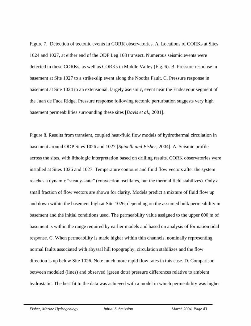
Fisher, Marine Hydrogeology Initial Submission March 2004, Page 43
Figure 7. Detection of tectonic events in CORK observatories. A. Locations of CORKs at Sites
1024 and 1027, at either end of the ODP Leg 168 transect. Numerous seismic events were
detected in these CORKs, as well as CORKs in Middle Valley (Fig. 6). B. Pressure response in
basement at Site 1027 to a strike-slip event along the Nootka Fault. C. Pressure response in
basement at Site 1024 to an extensional, largely aseismic, event near the Endeavour segment of
the Juan de Fuca Ridge. Pressure response following tectonic perturbation suggests very high
basement permeabilities surrounding these sites [Davis et al., 2001].
Figure 8. Results from transient, coupled heat-fluid flow models of hydrothermal circulation in
basement around ODP Sites 1026 and 1027 [Spinelli and Fisher, 2004]. A. Seismic profile
across the sites, with lithologic interpretation based on drilling results. CORK observatories were
installed at Sites 1026 and 1027. Temperature contours and fluid flow vectors after the system
reaches a dynamic “steady-state” (convection oscillates, but the thermal field stabilizes). Only a
small fraction of flow vectors are shown for clarity. Models predict a mixture of fluid flow up
and down within the basement high at Site 1026, depending on the assumed bulk permeability in
basement and the initial conditions used. The permeability value assigned to the upper 600 m of
basement is within the range required by earlier models and based on analysis of formation tidal
response. C. When permeability is made higher within thin channels, nominally representing
normal faults associated with abyssal hill topography, circulation stabilizes and the flow
direction is up below Site 1026. Note much more rapid flow rates in this case. D. Comparison
between modeled (lines) and observed (green dots) pressure differences relative to ambient
hydrostatic. The best fit to the data was achieved with a model in which permeability was higher

Fisher, Marine Hydrogeology Initial Submission March 2004, Page 44
within thin channels (10-10 m2, thick red line; 10-9 m2, thick green line). Dashed lines are
homogeneous permeability distributions, whereas thinner solid line indicates permeability in
narrow zones of 10-11 m2 (black).
Figure 9. Cartoon showing hydrothermal circulation on a ridge flank between basaltic seamounts
separated by 50 km, as described by Fisher et al. [2003a; 2003b]. Water and crustal depths are
approximately correct, but cartoon is vertically exaggerated. Lithospheric heat rises from below
the crustal aquifer, generating lateral differences in fluid density. Seamounts allow fluids to
bypass the low-permeability sediment cover found throughout most ocean basins on seafloor
older than a few to a few tens of millions of years in age, and thus may be responsible for the
bulk of hydrothermal circulation occurring within the seafloor. Additional details are described
in the text. Original artwork by Nicolle Rager, modified by the author.
Figure 10. Permeability versus effective stress relations near the toe of the Barbados accretionary
complex. A. Location map showing the accretionary complex (shaded) and locations of ODP
drilling sites near the front of deformation. Holes at these sites were drilled through the
accretionary wedge and into the décollement, the major plate boundary that separates the North
American and Caribbean Plates. B. Compilation of permeability estimates from packer and
CORK experiments [Fisher and Zwart, 1996; Fisher and Zwart, 1997; Screaton et al., 2000;
Screaton et al., 1997]. In general, the data suggest that there is a consistent (semi-log) relation
between bulk permeability and the modified pore pressure ratio, λ* =−
−
P P
P Pmeas hydrostat
lithostat hydrostat,
yielding the equation shown. Results from the cross-hole experiment are inconsistent with this
general trend. See text and references for additional details.

Fisher, Marine Hydrogeology Initial Submission March 2004, Page 45
Figure 11. Geologic and hydrogeologic setting and processes within the Mariana Forearc,
western Pacific Ocean [Fryer et al., 1999]. At this nonaccretionary subduction zone, the
underthrust plate releases heat, solutes, fluids, and mass that rise through faults in the overriding
plate and emerge at the seafloor, providing a unique window into processes occurring a depths
up to 25 km below the seafloor.
Figure 12. Summary of observational constraints and modeling results from a study of terrestrial-
marine ground water flow within the continental shelf, NE United States [Person et al., 2003]. A.
Geological setting and observed salinity profile [modified from Kohout et al., 1988]. B.
Computed salinity contours (dashed lines, ppt) after 10 sea-level rise-fall cycles about the
Pleistocene mean level (40 m below modern) using a period of 100,000 years with an amplitude
of 120m. C. Comparison of observed and computed salinity profiles. D - Computed salinity
contours using ice-sheet recharge boundary condition. Salinity patterns from the Pleistocene sea-
level simulation used as initial condition. E. Comparison of observed and computed salinity
profiles. F. Computed salinity contours using ice-sheet recharge boundary condition and a
continuous upper aquifer with a specified head boundary along the continental slope, assumed
exposed by cutting of a submarine canyon. Computed salinity patterns from the Pleistocene sea-
level simulation used as initial condition. G. Comparison of observed and computed salinity
profiles. This simulation best matches observational constraints.
Figure 13. Results from a study of coupled fluid flow and sediment deformation on the
continental shelf and slope offshore of New Jersey [Dugan and Flemings, 2000; Dugan and
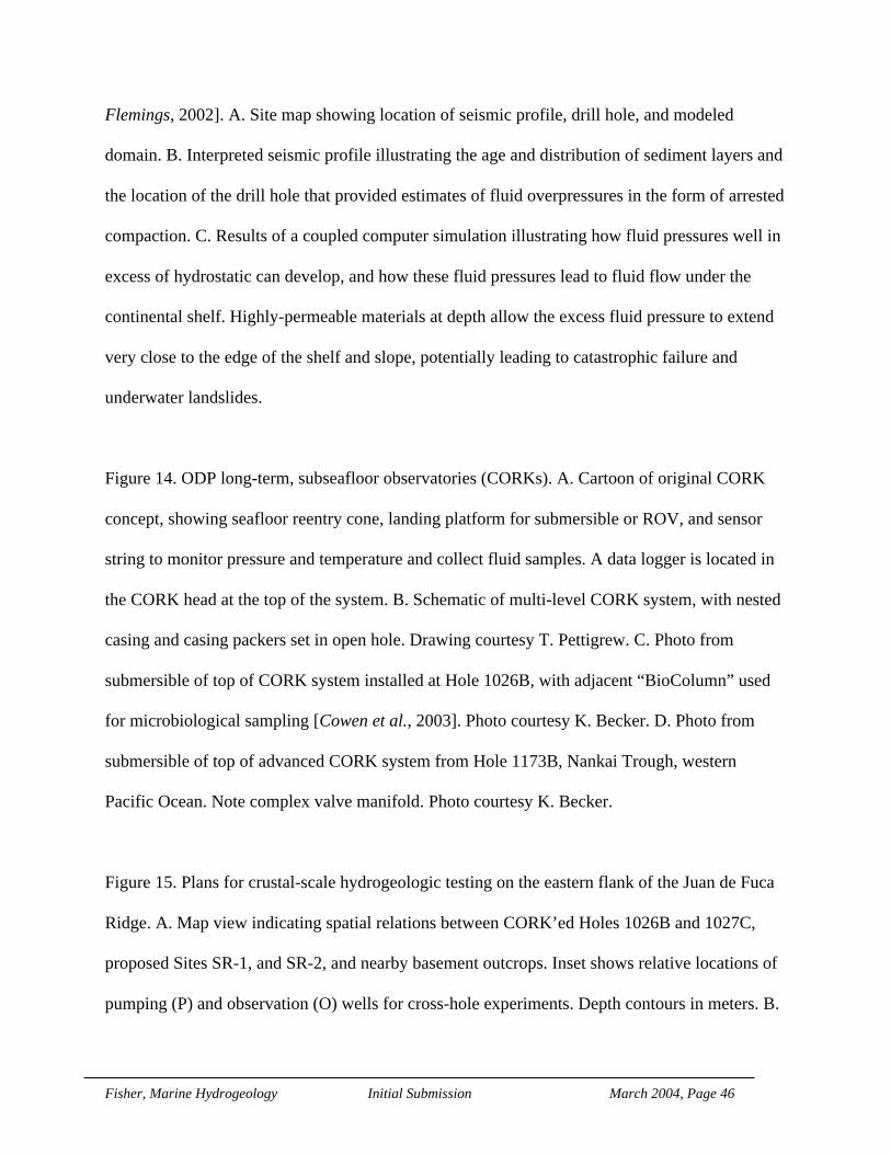
Fisher, Marine Hydrogeology Initial Submission March 2004, Page 46
Flemings, 2002]. A. Site map showing location of seismic profile, drill hole, and modeled
domain. B. Interpreted seismic profile illustrating the age and distribution of sediment layers and
the location of the drill hole that provided estimates of fluid overpressures in the form of arrested
compaction. C. Results of a coupled computer simulation illustrating how fluid pressures well in
excess of hydrostatic can develop, and how these fluid pressures lead to fluid flow under the
continental shelf. Highly-permeable materials at depth allow the excess fluid pressure to extend
very close to the edge of the shelf and slope, potentially leading to catastrophic failure and
underwater landslides.
Figure 14. ODP long-term, subseafloor observatories (CORKs). A. Cartoon of original CORK
concept, showing seafloor reentry cone, landing platform for submersible or ROV, and sensor
string to monitor pressure and temperature and collect fluid samples. A data logger is located in
the CORK head at the top of the system. B. Schematic of multi-level CORK system, with nested
casing and casing packers set in open hole. Drawing courtesy T. Pettigrew. C. Photo from
submersible of top of CORK system installed at Hole 1026B, with adjacent “BioColumn” used
for microbiological sampling [Cowen et al., 2003]. Photo courtesy K. Becker. D. Photo from
submersible of top of advanced CORK system from Hole 1173B, Nankai Trough, western
Pacific Ocean. Note complex valve manifold. Photo courtesy K. Becker.
Figure 15. Plans for crustal-scale hydrogeologic testing on the eastern flank of the Juan de Fuca
Ridge. A. Map view indicating spatial relations between CORK’ed Holes 1026B and 1027C,
proposed Sites SR-1, and SR-2, and nearby basement outcrops. Inset shows relative locations of
pumping (P) and observation (O) wells for cross-hole experiments. Depth contours in meters. B.

Fisher, Marine Hydrogeology Initial Submission March 2004, Page 47
Topography of top of basement around experimental sites based on dozens of seismic reflection
lines, showing tops of nearby outcrops (in white), Leg 168 Holes 1026B and 1027C, and planned
Sites SR-1 and SR-2 (stars). Image courtesy L. Zühlsdorff and V. Spiess. C. Idealized cross-hole
response to pumping and free-flow borehole experiments between wells at Sites SR-2 and
1026A, separated by 200 m. Formation properties based on packer, free flow, and CORK
experiments - differences in formation-scale values of T and S would shift the curve as indicated
by the arrows. Earlier pumping tests in DSDP and ODP were typically only 20 minutes long
(dotted vertical line); new tests will begin with 24 hours of pumping (dashed vertical line), and
ultimately will last 1-2 years or more through venting of overpressured holes and pumping at the
seafloor. D. Idealized cross-hole response in observation well located 2000 m from pumping
well (Sites SR-2 to 1027). Higher transmissivity is assumed based on greater measurement
spacing.
Figure 16. Proposed sites and components along the Nankai Trough active margin as part of the
NanTroSIEZE experiment. Poststack depth-migrated MCS profile showing the plate boundary,
accretionary prism, Kumano basin, and prominent splay fault system [after Park et al., 2002].
The seaward distribution of the 1944 Tonankai coseismic slip estimated from tsunami (red line)
and seismic (blue line) inversions are projected over the profile. Location of the décollement
stepdown to the top of the oceanic basement is marked with orange dotted circle. Proposed drill
sites are in some cases projected onto this line. B. Conceptual drilling and instrumentation plan
for Phase 3 (ultra deep) drilling at NT3-01A. Drilling would proceed with a mix of logging-
while-drilling and coring with casing to total depth, followed by sidetracking to core the prime
fault targets and install monitoring instrumentation. Sensors shown are positioned schematically.

Fisher, Marine Hydrogeology Initial Submission March 2004, Page 48
A number of sensor elements are not shown for clarity, including fiber optic temperature and
thermistor arrays, fluid pressure, and osmotic fluid sampling tubes.
Packers isolate perforated zones for fluid communication to the formation above, below, and
inside each of the 2 target fault zones. Borehole deviation is not to scale. Images courtesy of H.
Tobin.
Figure 17. Conceptual drawings of one part of the Ocean Research Interactive Observatory
Networks (ORION) program. ORION is intended to comprise regional, global, and coastal
components. A. Schematic of layout for fiber-optic power and data transmission cable that may
be used for regional observatory in the northeast Pacific Ocean (NEPTUNE) as part of ORION.
B. Schematic of various components of a fully functional NEPTUNE system, including borehole
and other tools that could be used for hydrogeologic experiments at the scale of a tectonic plate.
Images courtesy of NEPTUNE program.

Fisher, Marine Hydrogeology Initial Submission March 2004, Page 49
References Cited
Alt, J.C., D.A.H. Teagle, T. Brewer, W.C. Shanks, and A. Halliday, Alteration andmineralization of an oceanic forearc and the ophiolite-ocean crust analogy, J. Geophys.Res., 103 (B6), 12,365-12,380, 1998.
Bach, W., and S.E. Humphris, Relationship between Sr and O isotope compositions ofhydrothermal fluids and the spreading and magma supply rates at oceanic spreadingcenters, Geology, 27 (12), 1067-1070, 1999.
Baker, E.T., Y.J. Chen, and J.P. Morgan, The relationship between near-axes hydrothermalcooling and the spreading rate of mid-ocean ridges, Earth. Planet. Sci. Lett., 142, 137-145, 1996.
Baker, E.T., W. Levelle, R.A. Feely, G.J. Massoth, and S.L. Walker, Episodic venting on theJuan de Fuca Ridge, J. Geophys. Res., 94, 9237-9250, 1989.
Baker, E.T., and G.J. Massoth, Characteristics of hydrothermal plumes from two vent fields onthe juan de fuca ridge, northeast pacific ocean, Earth. Planet. Sci. Lett., 85, 59-73, 1987.
Baker, P., P. Stout, M. Kastner, and H. Elderfield, Large-scale lateral advection of seawaterthrough oceanic crust in the central equatorial Pacific, Earth. Planet. Sci. Lett., 105, 522-533, 1991.
Bangs, N.L., T.H. Shipley, J.C. Moore, and G.F. Moore, Fluid accumulation and channelingalong the northern Barbados Ridge decollement thrust, J. Geophys. Res., 104 (9), 20,399-20,414, 1999.
Bartetzko, A., P. Pezard, D. Goldberg, Y.-F. Sun, and K. Becker, Volcanic stratigraphy ofDSDP/ODP Hole 395A: an interpretation using well-logging data, Mar. Geophys. Res.,22 (111-127), 2001.
Becker, K., Special report: development and use of packers in ODP, JOIDES Journal, 12, 51-57,1986.
Becker, K., and E. Davis, New evidence for age variation and scale effects of permeabilities ofyoung oceanic crust from borehole thermal and pressure measuements, Earth. Planet.Sci. Lett., 201 (3-4), 499-508, 2003.
Becker, K., and E. Davis, In situ determinations of the permeability of the igneous oceanic crust,in Hydrogeology of the Oceanic Lithosphere, edited by E.E. Davis, and H. Elderfield,pp. in press, Cambridge University Press, Cambridge, UK, 2004.
Becker, K., and A. Fisher, Permeability of upper oceanic basement on the eastern flank of theEndeavor Ridge determined with drill-string packer experiments, J. Geophys. Res., 105(B1), 897-912., 2000.
Becker, K., A.T. Fisher, and E.E. Davis, The CORK experiment in Hole 949C: long termobservations of pressure and temperature in the Barbados accretionary prism, in Proc.ODP, Sci. Res., edited by Y. Ogawa, T. Shipley, P. Blum, and J. Bahr, pp. 247-252,Ocean Drilling Program, College Station, TX, 1997.
Becker, K., M. Langseth, R. Anderson, and M. Hobart, Deep crustal geothermal measurements,Hole 504B, Costa Rica Rift, Legs 69, 70, 83, and 92, in Init. Repts., DSDP, edited by R.Anderson, and J. Honnorez, pp. 405-418, U. S. Govt. Printing Office, Washington, D.C., 1985.
Becker, K., M. Langseth, R.P. Von Herzen, and R. Anderson, Deep crustal geothermalmeasurements, Hole 504B, Costa Rica Rift, J. Geophys. Res., 88, 3447-3457, 1983.
Becker, K., R.H. Morin, and E.E. Davis, Permeabilities in the Middle Valley hydrothermalsystem measured with packer and flowmeter experiments, in Proc. ODP, Sci. Res., edited

Fisher, Marine Hydrogeology Initial Submission March 2004, Page 50
by E.E. Davis, M.J. Mottl., A.T. Fisher, and J.F. Slack, pp. 613-626, Ocean DrillingProgram, College Station, TX, 1994.
Bekins, B., J.E. Blue, A.M. McCaffrey, and S.J. Dreiss, Modeling the origin of low chloride porewaters in a modern accretionary complex, Eos, Trans. Am. Geophys. Union, 75(supplement), 588, 1994.
Bethke, C.M., and T.M. Johnson, Paradox of groundwater age, Geology, 30 (2), 107-110, 2002.Biju-Duval, B.M., J. Casey; Bergen, James A. M.; Blackinton, Grant; Claypool, George E.;
Cowan, Darrel S.; Davis, Dan M.; Guerra, Rodolfo T.; Hemleben, Christoph H. J.;Marlow, Michael S.; Pudsey, Carol J.; Renz, G. W.; Tardy, Marc; Wilson, Douglas S.;Wright, Audrey W.; Natland, James H.; Hyndman, Roy D.; Salisbury, Matthew H.;Ballard, Alan; Becker, Keir; Denis, Jerome; Hickman, Stephen H.; Jacobson, Randy S.;Langseth, Marcus G.; Mathews, Mark A.; McGowan, Douglas; Nechoroshkov, VladislavL.; Ponomarev, Vladimir N.; Svitek, Joseph F.; Wallerstedt, Robert L.; Orlofsky, Susan,Init. Repts. Deep Sea Drilling Project, 78B, U. S. Govt. Printing Office, Washington, D.C., 1984.
Binns, R.A., F.J.A.S. Barriga, and D.J. Miller, Proc. ODP, Init. Repts., 193 [CD-ROM], OceanDrilling Program, College Station, TX, 2002.
Bischoff, J.L., and R.J. Rosenbauer, Salinity variations in submarine hydrothermal systems bylayered double-diffusive convection, J. Geology, 97, 613-623, 1989.
Brace, W.F., Permeability of crystalline and argillaceous rocks, Int. J. Rock Mech., and Min. Sci.,17, 241-251, 1980.
Bryant, W.R., A.P. Deflanche, and P.H. Trabant, Consolidation of marine clays and carbonates,in Deep-sea sediments, physical and mechanical properties, edited by A.L. Inderbitzen,pp. 209-244, Plenum Press, New York, 1974.
Buddemeier, R.W., Groundwater flux to the Ocean: Definitions, data, applications, uncertainties,in Groundwater Discharge in Coastal Zone: Proceedings of an International Symposium,edited by R.W. Buddemeier, pp. 16-21, LOICZ Reports and Studies No. 8, Texel, TheNetherlands, 1996.
Burnett, W.C., H. Bokuniewicz, M. Huettel, W.S. Moore, and M. Taniguchi Groundwater andpore water inputs to the coastal zone, Biogeochemistry, 66 (1-2),doi:10.1023/B:BIOG.0000006066.21240.53, 2003.
Carlson, R.L., Seismic velocities in the uppermost oceanic crust: age dependence and the fate oflayer 2A, J. Geophys. Res., 103 (B4), 7069-7077, 1998.
Carson, B., and E.J. Screaton, Fluid flow in accretionary prisms: Evidence for focused, time-variable discharge, Rev. Geophys., 36 (3), 329-351, 1998.
Cary, C., E. Delong, D. Kelley, and W.S.D. Wilcock, Subseafloor Biosphere at Mid-oceanRidges, in Geophysical Monograph, American Geophysical Union, Washington, DC,2004.
Cherkaoui, A.S.M., W.S.D. Wilcock, R.A. Dunn, and D.R. Toomey, A numerical model ofhydrothermal cooling and crustal accretion at a fast spreading mid-ocean ridge, G3, inpress, 2004.
Cherkauer, D.S., and D.C. Nader, Distribution of groundwater seepage to large surface waterbodies: the effect of hydraulic heterogeneities, J. Hydrol., 109, 151-165, 1989.
Clauser, C., Permeability of crystalline rocks, Trans. Am. Geophys. Union, 73, 233, 237-238,1992.

Fisher, Marine Hydrogeology Initial Submission March 2004, Page 51
Converse, D.R., H.D. Holland, and J.M. Edmund, Flow rates in the axial hot springs of the EastPacific Rise (21°N): implications for the heat budget and the formation of massive sulfidedeposits, Earth. Planet. Sci. Lett., 69, 159-175, 1980.
Cowen, J.P., S.J. Giovannoni, F. Kenig, H.P. Johnson, D. Butterfield, M.S. Rappé, M. Hutnak,and P. Lam, Fluids from aging ocean crust that support microbial life, Science, 299, 120-123, 2003.
Cutillo, P.A., E. Screaton, and G. Shemin, Three-dimensional numerical simulation of fluid flowand heat transport within the Barbados Ridge accretionary complex, J. Geophys. Res.,108 (12), doi: 10.1029/2002JB002240, 2003.
Davis, E., and K. Becker, Borehole observations record driving forces for hydrothermalcirculation in young oceanic crust, Eos, Trans. Am. Geophys. Union, 79 (31), 369,377-378, 1998.
Davis, E.E., and K. Becker, Observations of natural-state fluid pressures and temperatures inyoung oceanic crust and inferrences regarding hydrothermal circulation, Earth. Planet.Sci. Lett., 204, 231-248, 2002a.
Davis, E.E., and K. Becker, Using subseafloor boreholes for studying sub-seafloorhydrogeology: results from the first decade of CORK observations, Geoscience Canada,28 (4), 171-178, 2002b.
Davis, E.E., and K. Becker, Observations of temperature and pressure: constraints on oceancrustal hydrologic state, properties, and flow, in Hydrogeology of the OceanicLithosphere, edited by E.E. Davis, and H. Elderfield, pp. in press, Cambridge UniversityPress, Cambridge, UK, 2004.
Davis, E.E., K. Becker, T. Pettigrew, B. Carson, and R. MacDonald, CORK: a hydrologic sealand downhole observatory for deep-ocean boreholes, in Proc. ODP, Init. Repts., editedby E.E. Davis, M. Mottl, and A.T. Fisher, pp. 43-53, Ocean Drilling Program, CollegeStation, TX, 1992a.
Davis, E.E., D.S. Chapman, C. Forster, and H. Villinger, Heat-flow variations correlated withburied basement topography on the Juan de Fuca Ridge flank, Nature, 342, 533-537,1989.
Davis, E.E., D.S. Chapman, K. Wang, H. Villinger, A.T. Fisher, S.W. Robinson, J. Grigel, D.Pribnow, J. Stein, and K. Becker, Regional heat-flow variations across the sedimentedJuan de Fuca Ridge eastern flank: constraints on lithospheric cooling and lateralhydrothermal heat transport, J. Geophys. Res., 104 (B8), 17,675-17,688, 1999.
Davis, E.E., and H. Elderfield, Hydrogeology of the Oceanic Lithosphere, pp. in press,Cambridge University Press, Cambridge, UK, 2004.
Davis, E.E., and A.T. Fisher, On the nature and consequences of hydrothermal circulation in theMiddle Valley sedimented rift: inferences from geophysical and geochemicalobservations, Leg 139, in Proc. ODP, Sci. Res., edited by E.E. Davis, M.J. Mottl., A.T.Fisher, and J.F. Slack, pp. 695-717, Ocean Drilling Program, College Station, TX, 1994.
Davis, E.E., C.R.B. Lister, U.S. Wade, and R.D. Hyndman, Detailed heat flow measurementsover the Juan de Fuca Ridge system, J. Geophys. Res., 85, 299-310, 1980.
Davis, E.E., M.J. Mottl, A.T. Fisher, and e. al., Proceedings of the Ocean Drilling Program,Initial Reports, 1026 pp., Ocean Drilling Program, College Station, TX, 1992b.
Davis, E.E., and H. Villinger, Tectonic and thermal structure of the Middle Valley sedimentedrift, northern Juan de Fuca Ridge, in Proc. ODP, Init. Repts., edited by E.E. Davis, M.Mottl, and A.T. Fisher, pp. 9-41, Ocean Drilling Program, College Station, TX, 1992.
Fisher, Marine Hydrogeology Initial Submission March 2004, Page 52
Davis, E.E., K. Wang, K. Becker, and R.E. Thompson, Formation-scale hydraulic andmechanical properties of oceanic crust inferred from pore-pressure response to periodicseafloor loading, J. Geophys. Res., 105 (B6), 13423-13435, 2000.
Davis, E.E., K. Wang, J. He, D.S. Chapman, H. Villinger, and A. Rosenberger, An unequivocalcase for high Nusselt-number hydrothermal convection in sediment-buried igneousoceanic crust, Earth. Planet. Sci. Lett., 146, 137-150, 1997.
Davis, E.E., W. Wang, R.E. Thomson, K. Becker, and J.F. Cassidy, An episode of seafloorspreading and associated plate deformation inferred from crustal fluid pressure transients,J. Geophys. Res., 106 (B10), 21,953-21,963, 2001.
Detrick, R.S., A.B. Baggeroer, E. Delong, F.K. Duennebier, G.R. Heath, J.J. Hyon, T.C.Johnson, D.L. Michel, J. Oltman-Shay, S. Pouliquen, O.M.E. Schofield, and R.A. Weller,Enabling Ocean Research in the 21st Century: Implementation of a Network of OceanObservatories, 164 pp., National Academy Press, Washington, D. C., 2003.
Detrick, R.S., D.R. Toomey, and J.A. Collins, Three-dimensional upper crustal heterogeneityand anisotropy around Hole 504B from seismic tomography, J. Geophys. Res., 103(B12), 30485-30504, 1998.
Dick, H.J.B., J. Lin, and S. H, An ultraslow-spreading class of ocean ridge, Nature, 426 (6965),405-412, 2003.
Dugan, B., and P.B. Flemings, Overpressure and fluid flow in the New Jersey Continental Slope:implications for slope failure and cold seeps, Science, 289, 288-291, 2000.
Dugan, B., and P.B. Flemings, Fluid flow and stability of the US continental slope offshore NewJersey from the Pleistocene to the present, Geofluids, 2, 137-146, 2002.
Dugan, B., P.B. Flemings, D.L. Olgaard, and M.J. Gooch, Consolidation, effective stress, andfluid pressure of sediments from ODP Site 1073, US mid-Atlantic continental slope,Earth. Planet. Sci. Lett., 215 (1-2), 13-26, 2003.
Dunn, R.A., and D.R. Toomey, Crack-induced seismic anisotropy in the oceanic crust across theEast Pacific Rise (9° 30'N). Earth. Planet. Sci. Lett., 189 ((1-2)), 9-17, 2001.
Elderfield, H., C.G. Wheat, M.J. Mottl, C. Monnin, and B. Spiro, Fluid and geochemicaltransport through oceanic crust: a transect across the eastern flank of the Juan de FucaRidge, Earth. Planet. Sci. Lett., 172, 151-165, 1999.
Ferguson, I.J., Heat flow and thermal models of the barbados ridge accretionary complex, J.Geophys. Res., 98 (B3), 4121-4142, 1993.
Fisher, A., Geophysical constraints on hydrothermal circulation: observations and models, inEnergy and mass transfer in submarine hydrothermal systems, edited by P. Halbach, V.Tunnicliffe, and J. Hein, pp. 29-52, Dahlem University Press, Berlin, Germany, 2003a.
Fisher, A., Rates and patterns of fluid circulation, in Hydrogeology of the Oceanic Lithosphere,edited by H. Elderfield, pp. in press, Cambridge University Press, Cambridge, UK,2003b.
Fisher, A., Rates and patterns of fluid circulation, in Hydrogeology of the Oceanic Lithosphere,edited by E.E. Davis, and H. Elderfield, pp. 339-377, Cambridge University Press,Cambridge, UK, 2004.
Fisher, A., and K. Becker, Channelized fluid flow in oceanic crust reconciles heat-flow andpermeability data, Nature, 403, 71-74, 2000.
Fisher, A., E. Giambalvo, J. Sclater, M. Kastner, B. Ransom, Y. Weinstein, and P. Lonsdale,Heat flow, sediment and pore fluid chemistry, and hydrothermal circulation on the eastflank of Alarcon Ridge, Gulf of California, Earth. Planet. Sci. Lett., 188, 521 534, 2001.

Fisher, Marine Hydrogeology Initial Submission March 2004, Page 53
Fisher, A., and G. Zwart, The relation between permeability and effective stress along a plate-boundary fault, Barbados accretionary complex, Geology, 24, 307-311, 1996.
Fisher, A.T., Permeability within basaltic oceanic crust, Rev. Geophys., 36 (2), 143-182, 1998.Fisher, A.T., E.E. Davis, M. Hutnak, V. Spiess, L. Zühlsdorff, A. Cherkaoui, L. Christiansen,
K.M. Edwards, R. Macdonald, H. Villinger, M.J. Mottl, C.G. Wheat, and K. Becker,Hydrothermal recharge and discharge across 50 km guided by seamounts on a youngridge flank, Nature, 421, 618-621, 2003a.
Fisher, A.T., K. Fischer, D. Lavoie, M. Langseth, and J. Xu, Hydrogeological and geotechnicalproperties of shallow sediments at Middle Valley, northern Juan de Fuca Ridge, in Proc.ODP, Sci. Res., edited by M.J. Mottl, E.E. Davis, A.T. Fisher, and J.F. Slack, pp. 627-648, Ocean Drilling Program, College Station, TX, 1994.
Fisher, A.T., and M. Hounslow, Transient fluid flow through the toe of the Barbadosaccretionary complex: Evidence from ODP Leg 110 and simple analytical models, J.Geophys. Res., 95, 8845-8858, 1990.
Fisher, A.T., C.A. Stein, R.N. Harris, K. Wang, E.A. Silver, M. Pfender, M. Hutnak, A.Cherkaoui, R. Bodzin, and H. Villinger, Abrupt thermal transition reveals hydrothermalboundary and role of seamounts within the Cocos Plate, Geophys. Res. Lett., 30 (11),1550, doi:10.1029/2002GL016766, 2003b.
Fisher, A.T., and G. Zwart, Packer experiments along the décollement of the Barbadosaccretionary complex: measurements and in-situ permeability, in Proc. ODP, Sci. Res.,edited by Y. Ogawa, T. Shipley, P. Blum, and J. Bahr, pp. 199-218, Ocean DrillingProgram, College Station, TX, 1997.
Foucher, J.-P., P. Henry, and F. Harmegnies, Long-term observations of pressure andtemperature in Hole 948D, Barbados accretionary prism, in Proc. ODP, Sci. Res., editedby Y. Ogawa, T. Shipley, P. Blum, and J. Bahr, pp. 239-246, Ocean Drilling Program,College Station, TX, 1997.
Fouquet, Y., R.A. Zierenberg, and J. Miller, Proceedings of the Ocean Drilling Program, InitialReports 169, Ocean Drilling Program, College Station, TX, 1998.
Fryer, P., J.C. Pearce, and L.B. Stokking, Proc. Ocean Drilling Program, Sci. Results 125,Ocean Drilling Program, College Station, TX, 1992.
Fryer, P., C.G. Wheat, and M.J. Mottl, Mariana blueschist mud volcanism: implications forconditions within the subduction zone, Geology, 27 (2), 103-106, 1999.
FUMAGES, Report to the U. S. Science Advisory Committee, in Workshop on the Future ofMarine Geology and Geophysics, NSF, Ashland Hills, OR, 1997.
Gable, R., R. Morin, and K. Becker, Geothermal state of Hole 504B: ODP Leg 111 overview, inProc. ODP, Sci. Res., edited by K. Becker, and H. Sakai, pp. 87-96, Ocean DrillingProgram, College Station, TX, 1989.
Ge, S., B. Bekins, K.M. Brown, E. Davis, S.G. Gorelick, P. Henry, H. Kooi, A.F. Moench, C.Ruppel, M. Sauter, E. Screaton, P. Swart, T. Tokunaga, C. Voss, and F. Whitaker,Hydrogeology Program Planning Group, Final Report, Joint Oceanographic Institutionsfor Deep Earth Sampling, Washington, D. C., 2002.
Gieskes, J.M., P. Vrolijk, and G. Blanc, Hydrogeochemistry of the northern Barbadosaccretionary complex transect: Ocean Drilling Program Leg 110, J. Geophys. Res., 95,8809-8818, 1990.
Gillis, K., and P.T. Robinson, Distribution of alteration zones in the upper oceanic crust,Geology, 16, 262-266, 1988.

Fisher, Marine Hydrogeology Initial Submission March 2004, Page 54
Golden, C.E., S.C. Webb, and R.A. Sohn, Hydrothermal microearthquake swarms beneath activevents at Middle Valley, northern Juan de Fuca Ridge, J. Geophys. Res., 108 (B1),10.1029/2001JB000226, 2003.
Goode, D., J., Direct simulation of groundwater age, Wat. Resour. Res., 32, 289-296, 1996.Guerin, G., K. Becker, R. Gable, and P. Pezard, Temperature measurements and heat-flow
analysis in Hole 504B, in Proc. ODP, Sci. Res., edited by J.C. Alt, H. Kinoshita, L.B.Stokking, and P.J. Michael, pp. 291-296, Ocean Drilling Program, College Station, TX,1996.
Halbach, P., V. Tunnicliffe, and J. Hein, Energy and mass transfer in submarine hydrothermalsystems, in Dahlem Workship Report, Dahlem University Press, Berlin, Germany, 2003.
Harris, R.N., A.T. Fisher, and D. Chapman, Seamounts induce large fluid fluxes, Geology, inreview, 2004.
Haymon, R.M., The response of ridge-crest hydrothermal systems to segmented episodic magmasupply, in Tectonic, magmatic, hydrothermal, and biological segmentation of mid-oceanridges, edited by C.L. Walker, pp. 157-168, American Geophysical Union, Washington,D.C., 1996.
Haymon, R.M., D.J. Fornari, M.H. Edwards, S. Carbotte, D. Wright, and K.C. Macdonald,Hydrothermal vent distribution along the East Pacific Rise crest (9° 09'-54' N) and itsrelationship to magmatic and tectonic processes on fast-spreading mid-ocean ridges,Earth. Planet. Sci. Lett., 104, 513-534, 1991.
Henry, P., Fluid flow at the toe of the Barbados accretionary wedge constrained by thermal,chemical, and hydrogeologic observations and models, J. Geophys. Res., 105, 25855-25872, 2000.
Herzig, P.M., S.E. Humphris, D.J. Miller, and R.A. Zierenberg, Proc. ODP, Sci. Results, 158,Ocean Drilling Program, College Station, TX, 1988.
Hickey, J.J., An approach to the field study of hydraulic gradients in variable-salinity groundwater, Ground Water, 27 (4), 531-539, 1989.
Houtz, R., and J. Ewing, Upper crustal structure as a function of plate age, J. Geophys. Res., 81,2490-2498, 1976.
Hubbert, M.K., Darcy's law and the field equivalent of the flow of underground fluids, Trans.Am. Inst. Mining and Metal. Eng., 207, 222-239, 1956.
Humphris, S.E., R.A. Zierenberg, L.S. Mullineaux, and R.E. Thompson, Seafloor hydrothermalsystems: physical, chemical, biological, and geological interactions, in GeophysicalMonograph, pp. 466, American Geophysical Union, Washington, DC, 1995.
Hutnak, M., A.T. Fisher, C.A. Stein, R. Harris, K. Wang, E. Silver, G. Spinelli, M. Pfender, H.Villinger, R. MacKnight, P. Costa Pisani, H. DeShon, and C. Diamente, The thermal stateof 18-24 Ma upper lithosphere subducting below the Nicoya Peninsula, northern CostaRica margin, in MARGINS Theoretical Institute: SIEZE Volume, edited by T. Dixon, C.Moore, E. Silver, S. Stein, K. Furlong, and K. Brown, pp. in press, Columbia UniversityPress, New York, 2004.
Ingebritsen, S.E., and W.E. Sanford, Groundwater in geologic processes, Cambridge UniversityPress, New York, 2004.
Integrated Ocean Drilling Program (IODP) Planning Sub-Committee (IPSC), Earth, Oceans andLife, Initial Science Plan 2003-2013, Integrated Ocean Drilling Program, pp. 110,International Working Group, Washington, D. C., 2001.

Fisher, Marine Hydrogeology Initial Submission March 2004, Page 55
Jannasch, H.W., K.S. Johnson, and C. Sakamoto, M., Submersible, osmotically pumpedanalyzers for continuous determination of nitrate in situ, Anal. Chem., 66, 3352-3361,1994.
Johnson, H.P., K. Becker, and R.P.V. Herzen, Near-axis heat flow measurements on the northernJuan de Fuca Ridge: implications for fluid circulation in oceanic crust, Geophys. Res.Lett., 20 (17), 1875-1878, 1993.
Johnson, H.P., M. Hutnak, R.P. Dziak, C.G. Fox, I. Urcuyo, J.P. Cowen, J. Nabelek, and C.Fisher, Earthquake-induced changes in a hydrothermal system on the Juan de Fuca mid-ocean ridge, Nature, 407 (174-176), 2000a.
Johnson, H.P., and M.J. Pruis, Fluxes of fluid and heat from the oceanic crustal reservoir, Earth.Planet. Sci. Lett., 216 (565-574), 2003.
Johnson, H.P., M.J. Pruis, D. Van Patten, and M.A. Tivey, Density and porosity of the upperoceanic crust from seafloor gravity measurements., Geophys. Res. Lett., 27 (7), 1053-1056, 2000b.
Karson, J.A., Geologic structure of the uppermost oceanic crust created at fast- to intermediate-rate spreading centers, Ann. Rev. Earth Planet. Sci., 30, 347-384, 2002.
Kastner, M., Evidence for two distinct hydrothermal systems in the Gulf of California, in Init.Repts., DSDP, edited by J. Curray, and D. Moore, pp. 529-542, U. S. Govt. PrintingOffice, Washington, D. C., 1982.
Kelley, D.S., Volcanoes, fluids, and life at mid-ocean ridge spreading centers, Ann. Rev. EarthPlanet. Sci., 30, 385-391, 2002.
Kelley, D.S., J.R. Delaney, and D.R. Yoerger, Geology and venting dynamics of the Mothrahydrothermal field, Endeavour Segment, Juan de Fuca Ridge, Geology, 29 (10), 959-962,2001a.
Kelley, D.S., J.A. Karson, D.K. Blackman, G. Früh-Green, D.A. Butterfield, M.D. Lilley, E.J.Olson, M.O. Schrenk, K.K. Roe, G.T. Lebon, and P. Rivizzigno, An off-axishydrothermal vent field near the Mid-Atlantic Ridge at 30°N, Nature, 412, 145-149,2001b.
Kohout, F.A., G. Meisler, F.W. Meyer, R.H. Johnson, G.W. Leve, and R.L. Wait, Hydrogeologyof the Atlantic continental margin, in The Atlantic Continental Margin, edited by R.E.Sheridan, and J.A. Grow, pp. 463-480, Geol. Soc. Am., Boulder, CO, 1988.
Langseth, M., and K. Becker, Structure of igneous basement at sites 857 and 858 based on leg139 downhole logging, in Proc. ODP, Sci. Res., edited by E.E. Davis, M.J. �Mottl., A.T.Fisher, and J.F. Slack, pp. 573-583, Ocean Drilling Program, College Station, TX, 1994.
Langseth, M.G., and B. Herman, Heat transfer in the oceanic crust of the Brazil Basin, J.Geophys. Res., 86, 10805-10819, 1981.
Langseth, M.G., M.J. Mottl, M.A. Hobart, and A.T. Fisher, The distribution of geothermal andgeochemical gradients near Site 501/504, implications for hydrothermal circulation in theoceanic crust, in Proc. ODP, Init. Repts., edited by K. Becker, and H. Sakai, pp. 23-32,Ocean Drilling Program, College Station, TX, 1988.
Langseth, M.G., G.K. Westbrook, and M.A. Hobart, Contrasting thermal regimes of theBarbados accretionary ridge, J. Geophys. Res., 95, 8829-8844, 1990.
Larson, R.L., A.T. Fisher, and R. Jarrard, Highly layered and permeable Jurassic oceanic crust inthe western Pacific, Earth. Planet. Sci. Lett., 119, 71-83, 1993.
Manning, C.E., and S. Ingebritsen, Geological implications of a permeability-depth curve for thecontinental crust, Geology, 27 (12), 1107-1110, 1999.

Fisher, Marine Hydrogeology Initial Submission March 2004, Page 56
Mascle, A.M., J. Casey; Taylor, Elliott; Alvarez, Francis; Andreieff, Patrick; Barnes, Ross O.;Beck, Christian; Behrmann, Jan; Blanc, Gerard; Brown, Kevin M.; Clark, Murlene;Dolan, James F.; Fisher, Andrew; Gieskes, Joris M.; Hounslow, Mark; McLellan, Patrick;Moran, Kate; Ogawa, Yujiro; Sakai, Toyosaburo; Schoonmaker, Jane; Vrolijk, Peter J.;Wilkens, Roy H.; Williams, Colin, Proc. Ocean Drilling Program, Initial Reports 110,Ocean Drilling Program, College Station, TX, 1988.
McDonald, M.A., S.C. Webb, J.A. Hildebrand, and B.D. Cornuelle, Seismic structure andanisotropy of the Juan de Fuca Ridge at 45°N, J. Geophys. Res., 99, 4857-4873, 1994.
Moore, J.C., T.H. Shipley, D. Goldberg, Y. Ogawa, F. Filice, A. Fisher, M.-J. Jurado, G.F.Moore, A. Rabute, H. Yin, G. Zwart, and W. Brückmann, Abnormal fluid pressures andfault zone dilation in the Barbados accretionary prism: evidence from logging whiledrilling, Geology, 23, 605-608, 1995.
Moore, J.C.K., Adam; Bangs, Nathan L.; Bekins, Barbara A.; Brueckmann, Warner; Buecker,Christian J.; Erickson, Stephanie N.; Hansen, Olav; Horton, Thomas; Ireland, Peter;Major, Candace Olson; Moore, Gregory F.; Peacock, Sheila; Saito, Saneatsu; Screaton,Elizabeth J.; Shimeld, John W.; Stauffer, Philip Henry; Taymaz, Tuncay; Teas, Philip A.;Tokunaga, Tomochika, Proc. Ocean Drilling Program, Initial Reports 171A, OceanDrilling Program, College Station, TX, 1998.
Moores, E.M., and F.J. Vine, The Troodos massif, Cyprus, and other ophiolites as oceanic crust:evaluations and implications, Philos. Transactions of the Royal Society of London, SeriesA, 268, 443-466, 1971.
Mottl, M., Partitioning of energy and mass fluxes between mid-ocean ridge axes and flanks athigh and low temperature, in Energy and mass transfer in submarine hydrothermalsystems, edited by P. Halbach, V. Tunnicliffe, and J. Hein, pp. 271-286, DahlemUniversity Press, Berlin, Germany, 2003.
Mottl, M.J., S.C. Komor, P. Fryer, and C.L. Moyer, Deep-slab fluids fuel extremophilic Archaeaon a Mariana forearc serpentinite mud volcano: Ocean Drilling Program Leg 195, G3,4:10.1029/2003GC000588, 2003.
Mottl, M.J., C.G. Wheat, and J. Boulegue, Timing of ore deposition and sill intrusion at Site 856:evidence from stratigraphy, alteration, and sediment pore-water composition, in Proc.ODP, Sci. Res., edited by E.E. Davis, M.J. �Mottl., A.T. Fisher, and J.F. Slack, pp. 679-693, Ocean Drilling Program, College Station, TX, 1994.
Murton, B.J., L.J. Redbourn, C.G. German, and E.T. Baker, Sources and fluxes of hydrothermalheat, chemicals and biology within a segment of the Mid-Atlantic Ridge, Earth. Planet.Sci. Lett., 171, 301-317, 1999.
Mutter, J., and J. Karson, Structural processes at slow spreading ridges, Science, 257, 627-634,1992.
Neuman, S.P., and V. Di Federico, Multifaceded nature of hydrogeologic scaling and itsinterpretation, Rev. Geophys., 41 (3), doi: 10.1029/2003RG000130, 2003.
Neuzil, C.E., Abnormal pressures as hydrodynamic phenomena, Am. J. Sci., 295, 742-786, 1995.Noel, M., and M.W. Hounslow, Heat flow evidence for hydrothermal convection in Cretaceous
crust of the Madiera Abyssal Plain, Earth. Planet. Sci. Lett., 90, 77-86, 1988.Oberlander, P.L., Fluid density and gravitational variations in deep boreholes and their effect on
fluid potential, Ground Water, 27 (3), 341-350, 1989.

Fisher, Marine Hydrogeology Initial Submission March 2004, Page 57
Paillet, F.L., A.E. Hess, C.H. Cheng, and E. Hardin, Characterization of fracture permeabilitywith high-resolution vertical flow measurements during borehole pumping, GroundWater, 25, 28-40, 1986.
Park, J.-O., T. Tsuru, and S. Kodaira, Splay fault branching along the Nankai subduction zone,Science, 297, 1157-1160, 2002.
Parnell, J., Fluid seeps at continental margins: towards an integrated plumbing system,Geofluids, 2, 57-61, 2002.
Parsons, B., and J.G. Sclater, An analysis of the variation of ocean floor bathymetry and heatflow with age, J. Geophys. Res., 82, 803-829, 1977.
Person, M., B. Dugan, J.B. Swenson, L. Urbano, C. Stott, J. Taylor, and M. Millet, Pleistocenehydrogeology of the Atlantic continental shelf, New England, Geol. Soc. Am. Bull., 115(11), 1324-1343, 2003.
Phillips, S.W., and B.D. Lindsey, The influence of ground water on nitrogen delivery to theChesapeake Bay, pp. http://md.water.usgs.gov/publications/fs-091-03, U. S. Geol.Survey, Reston, VA, 2003.
Renshaw, C.E., Sample bias and the scaling of hydraulic conductivity in fractured rock,Geophys. Res. Lett., 25, 121-124, 1998.
Rovey, C.W.I., and D.S. Cherkauser, Scale dependency of hydraulic conductivity measurements,Ground Water, 33 (5), 769-780, 1995.
Ryan, W.B.F., R.S. Detrick, K. Becker, J. Bellingham, R. Lukas, J. Lupton, L. Mullineaux, andJ. Sipress, Illumating the Hidden Planet: the Future of Seafloor Observatory Science, 135pp., National Academy Press, Washington, D. C., 2000.
Sanford, W.E., Correcting for diffusion in Carbon-14 dating of ground water, Ground Water, 35(2), 357-361, 1997.
Schultz, A., J.R. Delaney, and R.E. McDuff, On the partitioning of heat flux between diffuse andpoint source seafloor venting, J. Geophys. Res., 97, 12299-12315, 1992.
Schulze-Makuch, D., and D.S. Cherkauer, Method developed for extrapolating scale behavior,Trans. Am. Geophys. Union, 78, 3, 1997.
Screaton, E., B. Carson, E. Davis, and K. Becker, Permeability of a decollement zone: Resultsfrom a two-well experiment in the
Barbados accretionary complex, J. Geophys. Res., 105 (B9), 21403-21410, 2000.Screaton, E., A. Fisher, B. Carson, and K. Becker, Barbados ridge hydrogeologic tests:
implications for fluid migration along an active décollement, Geology, 25, 239-242,1997.
Screaton, E., and G. Shemin, An assessment of along-strike fluid transport within the BarbadosRidge accretionary complex: results of preliminary modeling, J. Geophys. Res., 24 (23),3085-3088, 1997.
Screaton, E.J., D.R. Wuthrich, and S.J. Dreiss, Permeabilities, fluid presssures, and flow rates inthe Barbados Ridge complex, J. Geophys. Res., 95, 8997-9007, 1990.
Shipley, T.H., G.F. Moore, N.L. Bangs, J.C. Moore, and P.L. Stoffa, Seismically-inferreddilatancy distribution, northern Barbados Ridge decollement: implications for fluidmigration and fault strength, Geology, 22, 411-414, 1994.
Shipley, T.H.O., Yujiro; Blum, Peter; Ashi, Juichiro; Brueckmann, Warner; Filice, Frank; Fisher,Andrew; Goldberg, David; Henry, Pierre; Housen, Bernard; Jurado, Maria-Jose; Kastner,Miriam; Labaume, Pierre; Laier, Troels; Leitch, Evan C.; Maltman, Alex J.; Meyer,Audrey; Moore, Gregory F.; Moore, J. Casey; Peacock, Sheila; Rabaute, Alain; Steiger,

Fisher, Marine Hydrogeology Initial Submission March 2004, Page 58
Torsten H.; Tobin, Harold J.; Underwood, Michael B.; Xu, Yan; Yin, Hezhu; Zheng,Yan; Zwart, Gretchen, Proc. Ocean Drilling Program, Initial Reports 156, OceanDrilling Program, College Station, TX, 1995.
Sinha, M.C., S.C. Constable, C. Peirce, A. White, G. Heinson, L.M. MacGregor, and D.A.Navin, Magmatic processes at slow spreading ridges: implications
of the RAMESSES experiment at 57° 45' N on the Mid-Atlantic Ridge, Geophys. J. Int., 135,731-745, 1998.
Smith, W.H.F., and D.T. Sandwell, Global sea floor topography from satellite altymetry and shipdepth soundings, Science, 277, 1956-1962, 1997.
Spinelli, G., A.T. Fisher, C.G. Wheat, M.D. Tryon, K.M. Brown, and A.R. Flegal, Groundwaterseepage into northern San Francisco Bay: implications for dissolved metals budgets, Wat.Resour. Res., 38 (7), 10.1029/2001WR000827, 2002.
Spinelli, G.A., and A.T. Fisher, Hydrothermal circulation within rough basement on the Juan deFuca Ridge flank, Geochem., Geophys., Geosystems, 5 (2), Q02001,doi:10.1029/2003GC000616, 2004.
Spinelli, G.A., E.G. Giambalvo, and A.T. Fisher, Hydrologic properties and distribution ofsediments, in Hydrogeology of the Oceanic Lithosphere, edited by E.E. Davis, and H.Elderfield, pp. in press, Cambridge University Press, Cambridge, UK, 2004.
Stauffer, P.H., and B. Bekins, Modeling consolidation and dewatering near the toe of thenorthern Barbados accretionary complex, J. Geophys. Res., 106, 6369-6383, 2001.
Stein, C., and S. Stein, A model for the global variation in oceanic depth and heat flow withlithospheric age, Nature, 359, 123-129, 1992.
Stein, C.A., S. Stein, and A.M. Pelayo, Heat flow and hydrothermal circulation, in SeafloorHydrothermal Systems: Physical, Chemical, Biological and Geological Interactions,edited by S.E. Humphris, R.A. Zierenberg, L.S. Mullineaux, and R.E. Thompson, pp.425-445, American Geophysical Union, Washington, D. C., 1995.
Stein, J.S., and A.T. Fisher, Multiple scales of hydrothermal circulation in Middle Valley,northern Juan de Fuca Ridge: physical constraints and geologic models, J. Geophys. Res.,106 (B5), 8563-8580, 2001.
Stein, J.S., and A.T. Fisher, Observations and models of lateral hydrothermal circulation on ayoung ridge flank: reconciling thermal, numerical and chemical constraints, Geochem.,Geophys., Geosystems, 10.1029/2002GC000415, 2003.
Stephen, R., Seismic anisotropy observed upper oceanic crust, Geophys. Res. Lett., 8, 865-868,1981.
Stephen, R.A., Seismic anisotropy in the upper oceanic crust, J. Geophys. Res., 90, 11383-11396,1985.
Suess, E., M.E. Torres, G. Bohrmann, R.W. Collier, J. Greinert, P. Linke, G. Rehder, A. Trehu,K. Wallmann, G. Winckler, and E. Zuleger, Gas hydrate destabilization; enhanceddewatering, benthic material turnover and large methane plumes at the Cascadiaconvergent margin, Earth. Planet. Sci. Lett., 170 (1-2), 1-15, 1999.
Taniguchi, M., W.C. Burnett, C.F. Smith, R.J. Paulsen, D. O'Rourke, S.L. Krupa, and J.L.Christoff, Spatial and temporal distributions of submarine groundwater discharge ratesobtained from various types of seepage meters at a site in the Northeastern Gulf ofMexico, Biogeochemistry, 66 (1-2), doi:10.1023/B:BIOG.0000006090.25949.8d, 2003.

Fisher, Marine Hydrogeology Initial Submission March 2004, Page 59
Taylor, E., and J. Leonard, Sediment consolidation and permeability at the Barbados forearc, inProc. ODP, Sci. Res., edited by J.C. Moore, A. Mascle, and C. Auroux, pp. 129-140,Ocean Drilling Program, College Station, TX, 1990.
Theim, H., Hydrologische Methoden, 56 pp., Gebhardt, Leipzig, 1906.Tryon, M.D., K.M. Brown, L. Dorman, and A. Sauter, A new benthic aqueous flux meter for
very low to moderate discharge rates, DSR, 48 (9), 2121-2146, 2001.Vacquier, V., J.G. Sclater, and C.E. Corry, Studies in the thermal state of the earth, the 21st
paper: heat-flow, Eastern Pacific, Bulletin of the Earthquake Research Institute, 45, 375-393, 1967.
Villinger, H., I. Grevemeyer, N. Kaul, J. Hauschild, and M. Pfender, Hydrothermal heat fluxthrough aged oceanic crust: where does the heat escape?, Earth. Planet. Sci. Lett., 202(1), 159-170, 2002.
Von Herzen, R.P., Geothermal evidence for continuing hydrothermal circulation in older (>60Ma) ocean crust, in Hydrogeology of the Oceanic Lithosphere, edited by E.E. Davis, andH. Elderfield, pp. in press, Cambridge University Press, Cambridge, UK, 2004.
Wang, K., and E.E. Davis, Theory for the propagation of tidally induced pore pressure variationsin layered subseafloor formations, J. Geophys. Res., 101, 11,483-11,495, 1996.
Wang, K., J. He, and E.E. Davis, Influence of basement topography on hydrothermal circulationin sediment-buried oceanic crust, Earth. Planet. Sci. Lett., 146, 151-164, 1997.
Wheat, C.G., Fluid circulation and diagenesis in an off-axis hydrothermal system: the MarianaMounds, Ph. D. thesis, University of Washington, 1990.
Wheat, C.G., H.W. Jannasch, M. Kastner, J.N. Plant, and E. DeCarlo, Seawater transport andreaction in upper oceanic basaltic basement: chemical data from continuous monitoringof sealed boreholes in a ridge flank environment, G3, in press, 2004a.
Wheat, C.G., H.W. Jannasch, J.N. Plant, C.L. Moyer, F.J. Sansone, and G.M. McMurtry,Continuous sampling of hydrothermal fluids from Loihi Seamount after the 1996 event,J. Geophys. Res., 105 (8), 19353-19367, 2000.
Wheat, C.G., M.J. Mottl, A.T. Fisher4, D. Kadko, E.E. Davis, and E. Baker, Heat and fluid flowthrough a basaltic outcrop on a ridge flank, G3, in review, 2004b.
Wilcock, W.S.D., S.D. Archer, and G.M. Purdy, Microearthquakes on the Endeavour segment ofthe Juan de Fuca Ridge, J. Geophys. Res., 107, doi:10.1029/ 2001JB000505, 2002.
Wilcock, W.S.D., and A.T. Fisher, Geophysical constraints on the sub-seafloor environment nearmid-ocean ridges, in Subseafloor Biosphere at Mid-ocean Ridges, edited by C. Cary, E.Delong, D. Kelley, and W.S.D. Wilcock, pp. in press, American Geophysical Union,Washington, D. C., 2004.
Williams, D.L., and R.P. Von Herzen, Heat loss from the earth: new estimate, Geology, 2, 327-328, 1974.
Williams, D.L., R.P. Von Herzen, J.G. Sclater, and R.N. Anderson, The Galapagos SpreadingCentre, lithospheric cooling and hydrothermal circulation, Geophys. J. R. astr. Soc., 38,587-608, 1974.
Zoback, M.D., and R.N. Anderson, Permeability, underpressures, and convection in the oceaniccrust at Deep Sea Drilling Project Hole 504B, in Init. Repts., DSDP, edited by C. J., andM.G. Langseth, pp. 245-254, U. S. Govt. Printing Office, Washington, D. C., 1983.
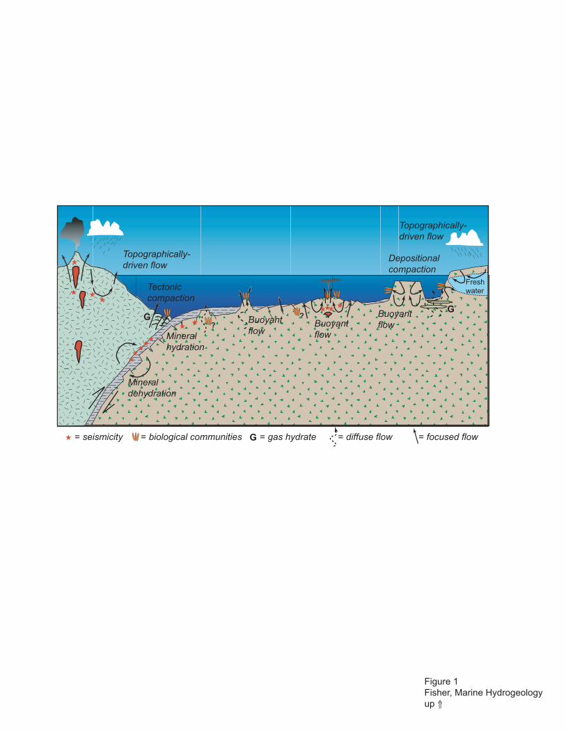
Figure 1Fisher, Marine Hydrogeologyup ⇑
Topographically-driven flow
Tectonic compaction
Depositionalcompaction
Buoyantflow
Mineralhydration
Mineraldehydration
= seismicity
G
Fresh water
G
Topographically-driven flow
Buoyantflow
Buoyantflow
= biological communities G = gas hydrate = diffuse flow = focused flow
??
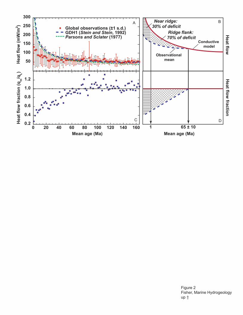
0.2
0.4
0.6
0.8
1.0
1.2
0 20 40 60 80 100 120 140 160
Hea
t fl
ow
fra
ctio
n (
qm
/qL)
Mean age (Ma)
50
100
150
200
250
300
Global observations (±1 s.d.)GDH1 (Stein and Stein, 1992)Parsons and Sclater (1977)
Hea
t fl
ow
(m
W/m
2 )
Conductive model
Observational mean
Heat flo
w
Heat flo
w fractio
n
Near ridge: 30% of deficit
Ridge flank: 70% of deficit
Mean age (Ma)
1 65 ± 10
Figure 2Fisher, Marine Hydrogeologyup ⇑
A B
C D

Thermal sources (+/-)and boundaries Stress sources (+/-)
and boundaries
Solute sources (+/-)and boundaries
Fluid sources (+/-)and boundaries
Fluidtransport
Solutetransport
Energytransport
Crustalmechanics
Thermal properties
Thermal state
Chemical properties
Chemical state
Mechanical stateMechanical properties
Hydrodynamic stateFluid properties
Permeability DistributionBiological properties
Biological state Biologicaldynamics
Rock/magma sources
Rock/magma sources
Figure 3Fisher, Marine Hydrogeologyup ⇑

100
200
300
400
500
600
700
800
900
1000
1100
1200
Dep
th in
to b
asem
ent (
m)
fault zone?
Hole 896A (5.9 Ma)
Pac
ker
mea
sure
men
ts
Hole 801C (157.4-166.8 Ma)
Hole 735B (gabbro, 11.7 Ma)
Hole 857D (sill/sediment, ≤0.2 Ma)
?
Hole 858G (≤0.2 Ma)
Hole 395A (7.3 Ma)
Hole 504B (5.9 Ma)
Hole 1027C (3.6 Ma)
Hole 1026B (3.5 Ma)
Hole 1024C (0.9 Ma)
Hole 1025C (1.2 Ma)
Bo
reh
ole
th
erm
al
mea
sure
men
ts
Bas
alti
c b
asem
ent
No
n-b
asal
tic
bas
emen
tHole 839B (2.2 Ma)
Figure 4Fisher, Marine Hydrup ⇑

Sedimentation rate = 5 m/my
Sedimentation rate = 50 m/my
0 2 4 6 8 10
?
?
Hole839B
Hole 858G
Hole1025C
Hole1024C
Hole1026B
Hole1027C
Hole504B
Hole896A
Hole395A
Crustal age (Ma)
A
B
Holes504B and
896A
10-9
1 10 100 1000 104 105
Per
mea
bilty
(m
2 )
Approximate measurement scale (m)
Observatoriesand thermal
modeling
Slugtests
Injectiontests
Boreholeflow
10-11
10-13
10-15
10-17
10-9
10-11
10-13
10-15
Per
mea
bilty
(m
2 )
Long-term, active, cross-hole experiments
Figure 5Fisher, Marine Hydrogeologyup ⇑
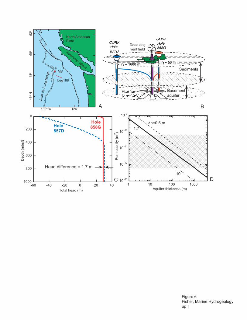
MV
Juan
de
Fuc
a R
idge
North AmericanPlate
Vancouver Island
130o W 126o
46o
N48
o50
o52
o
Leg168
Sediments
Dead dogvent field
����������
����������
-60 -40 -20 0 20 40
0
200
400
600
800
1000
Total head (m)
Dep
th (
mbs
f)
Hole858GHole
857D
Head difference = 1.7 m
C 10-13
10-12
10-11
10-10
10-9
1 10 100 1000
Per
mea
bilit
y (m
2 )
Aquifer thickness (m)
r1 ~ 50 mr2 ~ 1600 m
Basementaquifer
D
A B
��������������������
∆h=0.5 m1.7
10
Figure 6Fisher, Marine Hydrogeologyup ⇑

Figure 7Fisher, Marine Hydrogeologyup ⇑
Time since CORK installed (days)3200 3250 3300
Rel
ativ
e p
ress
ure
(kP
a) 0.0
-0.2
-0.4
-0.6
-0.8
Response atSite 1027
to 1996 eventm ~ 6.3
Site1024 Sites1026
and 1027
4
3
2
1
0
Rel
ativ
e p
ress
ure
(kP
a)
Time since CORK installed (days)4175 4180 4185
Response atSite 1024
to 1999 eventm ~ 2.8
Nootka
Fault
Juan de Fuca Ridge
50o N
49o
48o
47o
129o 128o 127o WA
B
C
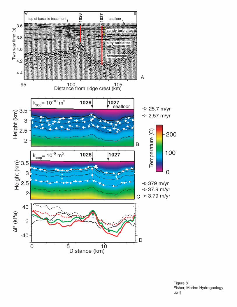
1026
1027
Two-
way
tim
e (s
) 3.6
3.8
4.0
4.2
4.4
95 100 105Distance from ridge crest (km)
W E
seafloortop of basaltic basement
sandy turbidites
silty turbidites
hemipelagic
Heig
ht (k
m)
2
2.5
3
3.5
10271026k600= 10-10 m2
25.7 m/yr2.57 m/yr
Tem
pera
ture
(C
)
0
100
200
10271026kloop= 10-9 m2
Distance (km)0 5 10
He
igh
t (k
m)
2
2.5
3
3.5
seafloor
379 m/yr37.9 m/yr3.79 m/yr
0
-40
40
∆P
(kP
a)
A
B
C
D
Figure 8Fisher, Marine Hydrogeologyup ⇑

1 km
2 km
3 km
4 km
5 km
6 km
© Nicolle Rager 2003
hydrothermalrecharge
hydrothermaldischarge
Figure 9Fisher, Marine Hydrogeologyup ⇑

61o W
100 kmBarbados
Barbados
South America
59o 57o W
14o N
17o N
16o
15o
A
BHigher fluid pressure
Gre
ater
per
mea
bil
ity
������������ ����������������
���������� ������
10-13
10-14
Bu
lk p
erm
eab
ility
, kb (
m2 )
10-15
10-16
10-17
Modified pore pressure ratio, λ*
1.0 0.8 0.6 0.4 0.2 0.0
-log kb = 18.16 - 5.47 λ*
�������� ���������������
?
������ ������������������� !
Figure 10Fisher, Marine Hydrogeologyup ⇑
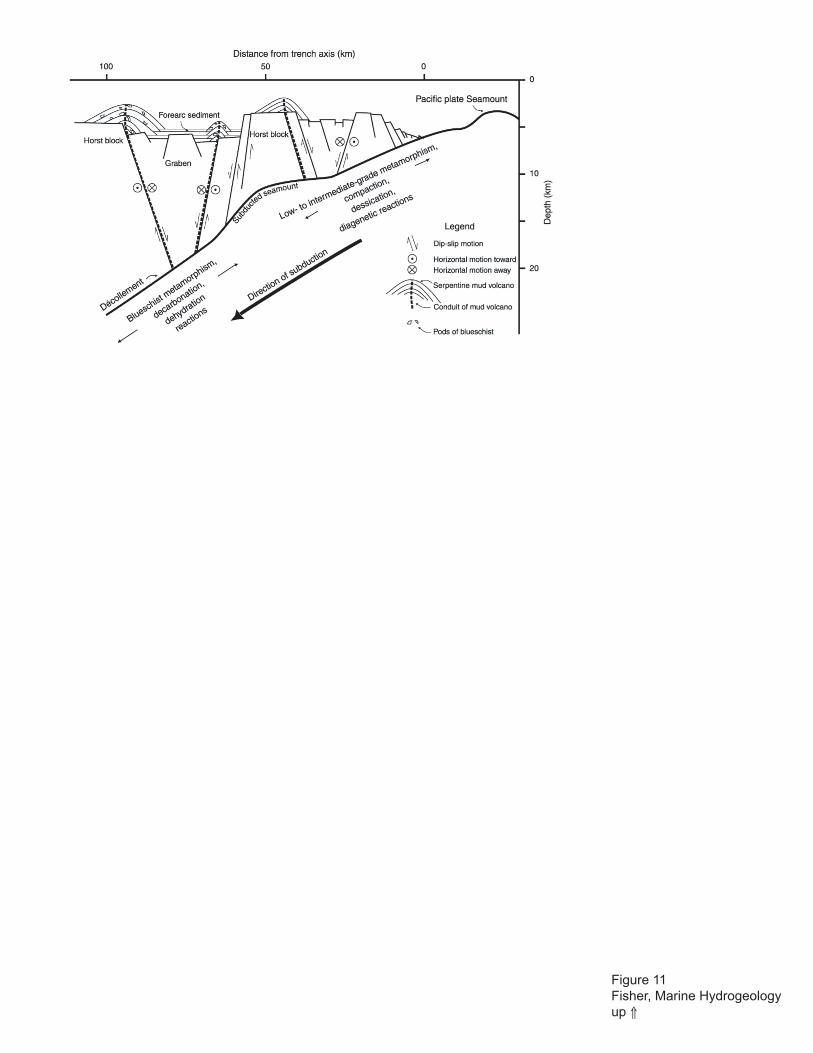
Figure 11Fisher, Marine Hydrogeologyup ⇑

Aí
0
1
2
3
4
30
5
Ice Sheet Simulation D
Aí
Salinity (ppt)
SandSilt/ClayCarbonate
10
0 100 200Distance (km)
280
0
1
2
3
4
30
5
Ice Sheet Simulation with Laterally Continuous Upper Aquifer400
100
200
300
0
400
100
200
300
0
E
F G
PleistoceneMean Sea Level
Aí
6009
0
1
2
3
4
Modern Shoreline PleistoceneSea LevelLow Stand
Sea Level Simulation B
30
5
A A'
151050
1071
CO
ST
B2
6021
6020
6011
6009
0
1
2
3
1073
4Observed A
De
pth
(km
)
0.02
0.01
0.03
0.00
400
100
200
300
0
Salinity (kg/kg)
Dep
th (
m)
6009
C
observed
mod
el
3000
CostG-1
CostG-2
0 25 50km
68o
72o
40o
43oNH
MA
RI
CapeCod
2000
200
100
60
100
60
NY
A'
6020
6011
CostB-2
LongIsland
0500
1000
1500
2000
A
6009
41o
39o
70o
74o
HudsonCanyon6021
Figure 12Fisher, Marine Hydrogeologyup ⇑

100
1000
2000
3000
41 No
39 No
74 Wo 72 Wo76 Wo
����
����
0
1
2
Two-
way
trav
el ti
me
(s)
0 km
Olig-Mio Bdry
20
Mio-Plio BdryS
ite 1
073
Site
107
3
0.5
km
0 MPa
P* (MPa)0 5.41.0 2.1 3.2 4.3
7 mm/yr
Specific discharge
5 km
8 MPa
2 MPa
4 MPa6 MPa
0 MPa
A
B
C
Figure 13Fisher, Marine Hydrogeologyup ⇑

Fluidsampler
Open holeor perforatedcasing
Casing
Sensorstring
Pressure Recorder
ROV Platform
20 in. Casing
10-3/4 in. Casing Packer
TD of LWD Borehole
Top of Fill
9-7/8 in. Borehole
17-1/2 in. Borehole
Wireline Retrievable Bridge Plug
10-3/4 in. Casing Screens
Packer Inflation Line
10-3/4 in. Casing
Seafloor
Reentry Cone
Sampling Ports/Valves
Top of ACORK Head
AB
C D
Figure 14Fisher, Marine Hydrogeologyup ⇑

127o 50'W127o 40'W
47o 40'N
47o 50'N
Depth (m)2400
3200
Hole 1027C
2 km
P
O
O
O
127° 50' W 127° 40'
47°
40'
47°
55' N
10 km
2630
2640
2650
2670
2680
2690
BabyBare
MamaBare
PapaBare
2660
2660
Hole 1026B
Hole SR-2AHole SR-1A
2660
B
Papa Bare
Mama Bare
BabyBare
Hole 1026B
Hole 1027C
SR-1
SR-2
SecondRidge
A
10
100
0.01 0.1 1 10 100
Time (days)
For
mat
ion
pres
sure
res
pons
e (k
Pa)
10 100 1000 104 105 106
Borehole spacing:2000 m
1
10
100
Time (min)
C
D
Lower T
Higher T
Lower S
Higher S
T = 5 x 10⁻⁴ m2/sS = 4 x 10⁻⁵
T = 1x 10⁻³ m2/sS = 4 x 10⁻⁵
Borehole spacing:200 m
Figure 15Fisher, Marine Hydrogeologyup ⇑

A
B
Figure 16Fisher, Marine Hydrogeologyup ⇑

Figure 17Fisher, Marine Hydrogeologyup ⇑
A B