marina robles moriche geography and history · 1. the hydrosphere: distribution and water cycle. 2....
TRANSCRIPT

Geography and History
1 ESOBilingual learning
Marina Robles Moriche
Cubierta provisional

Geography and History
1 ESOBilingual learning
Marina Robles Moriche

Edición del 2017
Autora: Marina Robles Moriche
Maquetación: Jessica Sánchez Gavilán
Edita: Educàlia Editorial
Imprime: Servicecom
ISBN: 978-84-946884-0-9
Deposito Legal: V-835-2017
Printed in Spain/Impreso en España.
Todos los derechos reservados. No está permitida la reimpresión de ninguna parte de este libro, ni de imágenes ni de texto, ni tampoco su reproducción, ni utilización, en cualquier forma o por cualquier medio, bien sea electrónico, mecánico o de otro modo, tanto conocida como los que puedan inventarse, incluyendo el fotocopiado o grabación, ni está permitido almacenarlo en un sistema de información y recupe-ración, sin el permiso anticipado y por escrito del editor.
Alguna de las imágenes que incluye este libro son reproducciones que se han realiza-do acogiéndose al derecho de cita que aparece en el artículo 32 de la Ley 22/18987, del 11 de noviembre, de la Propiedad intelectual. Educàlia Editorial agradece a to-das las instituciones, tanto públicas como privadas, citadas en estas páginas, su co-laboración y pide disculpas por la posible omisión involuntaria de algunas de ellas.
Educàlia Editorial, S.L.Avda. de les Jacarandes, 2, loft 327 - 46100 Burjassot
Tel: 960 624 309 - 963 768 542 - 610 900 111
E-mail: [email protected]
www.e-ducalia.com

Part I. The physical environment
Unit 1: The Earth1. The Earth in the Solar System
2. The Earth’s movements and their consequences.
3. Representation of the Earth: latitude and longitude.
3.1. Globes, maps, plans.
3.2. Latitude and longitude
Unit 2: Basic components and relief shapes.1. The elements of the physical environment.
2. The composition of the planet.
3. Atmosphere and atmospheric phenomena.
4. Lands, inland waters and seas.
4.1. Seas and oceans
4.2. Lands
4.2.1. The Great European Plain.
4.2.2. Massifs, plateaus and ancient mountains.
4.2.3. The young mountains of southern Europe.
4.2.4 The coastal relief.
4.3. Inland waters
Unit 3: Climates: Spain, Europe and the World. 1. The hydrosphere: distribution and water cycle.
2. Meteorology, climate and weather.
3. Distribution of climates. Cold, warm and template areas. Climates in Europe and Spain.
4. Natural hazards.
Part II. The human space
Unit 4: Maps1. The maps and the scales.
2. Location on the map of continents, oceans, seas, relief units and rivers in the World, in Europe and in Spain.
Unit 5. Spain, Europe and the World’s the population1. Territorial organization.
2. Demographic models
2.1. Composition of the population
3. Migratory movements.
3.1. Movements of European emigration.
3.2. Immigration to Europe.
3.3. Migrations in the interior of Europe
4. The city and the process of urbanization.
4.1. Urbanization process.
4.2. European cities.
4.3. Problems in the cities.
4.3.1 Atmospheric pollution.
4.3.2. Acoustic pollution.
4.3.3. Excessive water consumption.
4.3.4. Energy consumption.
4.3.5. Urban waste.
Unit 6. The political map of Spain and Europe1. Location on the map of the countries and big cities of the World.
2. Location on the map of the countries and big cities of Europe.
3. Location on the map of the cities of Spain.
3.1. Spanish largest cities

Part III: History
Unit 7: Prehistory1. Evolution of species and hominization.
2. Periodization in the Prehistoric
2.1. Human time scale
2.2. Geological time scale
2.3. Cosmological time scale
3. Paleolithic:
3.1. Stages
3.2. Characteristics of life forms: hunter-gatherers.
4. Neolithic
4.1. The agrarian revolution and the expansion of human societies.
4.2. Sedentary lifestyle.
4.3. Crafts and trade.
4.4. Social organization.
4.5. Appearance of the rites: remains.
4.6. Materials and art: painting and sculpture.
4.7. The End of the Neolithic.
Unit 8: Ancient History1. The first civilizations. Urban culture. Mesopotamia and Egypt. Society, economy
and culture.
1.1.Mesopotamia
1.2. Egypt
2. The Classical World, Greece: the Greek “Polis”, its commercial and political expansion
3. The empire of Alexander the Great and his successors: Hellenism. Art, science, theater and philosophy.
4. The Classical World. Rome: origin and stages of the history of Rome. The repub-lic and the empire: political organization and colonial expansion by the Medi-terranean. Christianity.

4.1. Rome strategic location
4.2. Rome dominance
4.3. Punic wars
4.4. Christianity
4.5. Roman Republic
Unit 9: The Iberian Peninsula: the pre-Roman peoples and Roman Hispania1.The pre- Romans
1.1. The Iberians
1.2. The Celts
1.3. The Tartessos
1.4. The Phoenicians
1.5. The the Greeks
1.6. The Carthaginians
2. The process of romanization.
3. The city and the countryside.
4. Art: architecture, sculpture and painting.
5. The Germanic invasions in the Iberian Peninsula: the Visigoths.
5.1. During the 5th century
5.2. During the 6h century
5.3. During the 7h century
5.4. During the 8h century
GEOGRAPHY AND HISTORY 1ST ESO BILINGUAL LEARNING
7
PART 1: The physical environment
UNIT 1 The Earth
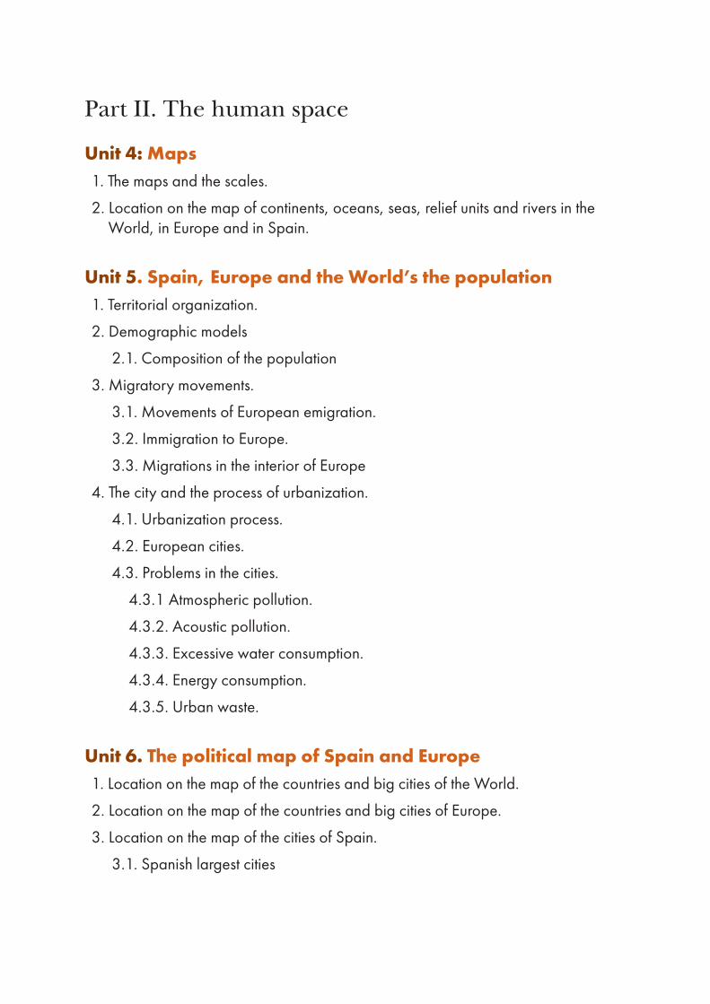
1. The Earth in the Solar SystemThe universe is everything that exists, including planets, stars, galaxies, the contents of intergalactic space, and all matter and energy. The geocentric models were developed by the ancient Greek philosophers, who believed the Earth was the centre of the Universe. Observations of the sky revealed this to be wrong, and in the 15th century heliocentric models were developed. The fi rst ones said the Sun was the centre of the Universe, while today we know that the Sun is only the centre of the Solar System.
GEOCENTRISM HELIOCENTRISM
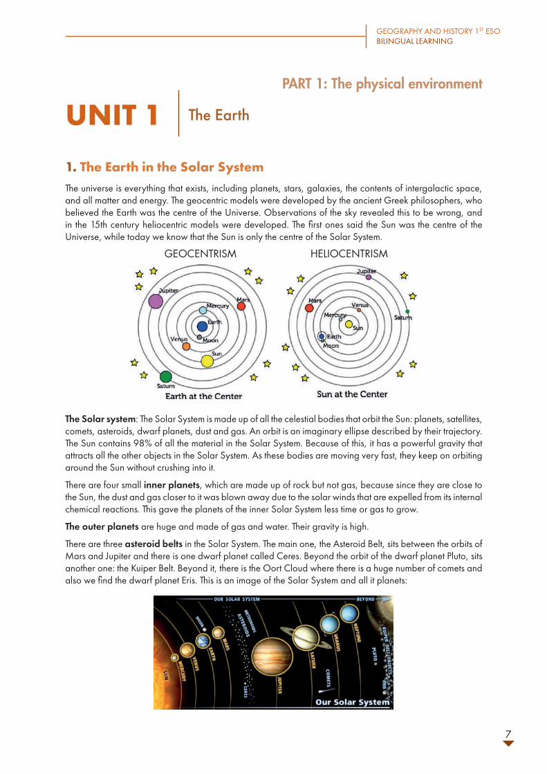
The Solar system: The Solar System is made up of all the celestial bodies that orbit the Sun: planets, satellites, comets, asteroids, dwarf planets, dust and gas. An orbit is an imaginary ellipse described by their trajectory. The Sun contains 98% of all the material in the Solar System. Because of this, it has a powerful gravity that attracts all the other objects in the Solar System. As these bodies are moving very fast, they keep on orbiting around the Sun without crushing into it.
There are four small inner planets, which are made up of rock but not gas, because since they are close to the Sun, the dust and gas closer to it was blown away due to the solar winds that are expelled from its internal chemical reactions. This gave the planets of the inner Solar System less time or gas to grow.
The outer planets are huge and made of gas and water. Their gravity is high.
There are three asteroid belts in the Solar System. The main one, the Asteroid Belt, sits between the orbits of Mars and Jupiter and there is one dwarf planet called Ceres. Beyond the orbit of the dwarf planet Pluto, sits another one: the Kuiper Belt. Beyond it, there is the Oort Cloud where there is a huge number of comets and also we fi nd the dwarf planet Eris. This is an image of the Solar System and all it planets:

UNIT 1:The Earth
8
Our home planet Earth is a rocky planet. It has a solid surface, but water covers 70% of it. The Earth has an atmosphere where nitrogen is the main gas, but it also has oxygen and other gases. The atmosphere protects us from incoming meteoroids and from solar dangerous radiation and it keeps an average temperature of 15ºC thanks to which there is liquid water. Because of all these facts, the Earth is the only planet known to contain living organisms.
ACTIVITIES1. Complete these sentences. Search for information
if you need:
a. The Earth is a _________ planet.b. _________ covers 70% of its surface.c. The Earth’s atmosphere has _________ as
the main gas.d. The Earth’s atmosphere protects us from
__________ and from _________ radiation and it keeps a right temperature for ________ water to exist.
e. Earth is the _______ planet known to contain _______ organisms.
f. _________ are large groups of stars, dust, gas and dark matter held together by _______. They vary in size and shapes.
g. _______ are spherical bodies made of _______ and ice and their orbit is very __________.
h. _______ is a huge, bright ball of burning gas that is held together by ________.Stars contain mostly __________ as well as helium and smaller amounts of other elements.
i. ___________ are not spherical bodies made of _______ and metal.
j. A ________ is a rocky spherical body that orbits a star.
k. A ________ is a rocky spherical body that orbits a planet.
2. Draw a picture of the Solar System in your notebook. Write the names of the star, of each planet or dwarf planet, and draw the location of the three asteroids belts.
3. Complete the table about the Solar System planets:
NAMES MAIN CHARACTERISTICS
INNER PLANETS
OUTER PLANETS
2. The Earth’s movements and their consequences.The Earth, as other celestial bodies, has two main movements:
• Rotation: it is the movement of the Earth’s on its own imaginary axis from West to East, and it takes 24 hours or one day. Its consequences are the days and nights.
• Revolution: it is the trajectory around the Sun in an elliptic orbit. It takes the Earth one year to complete an orbit around the Sun. Its consequences are the seasons of year. Solstices are the days with most difference between day and night number of hours, and they correspond to the beginning of summer and winter. On the other hand, equinoxes are the days in which day and night last the same, and they correspond to the beginning of spring and autumn.
EARTH ROTATION AND REVOLUTION

GEOGRAPHY AND HISTORY 1ST ESO BILINGUAL LEARNING
9
SEASONS OF YEAR (IN NORTH HEMISPHERE)
The Earth´s natural satellite is the moon. Its surface is rocky and cratered. This is due to the lack of atmosphere, so that meteorites impact its surface. It also orbits the Sun together with the Earth. The different grade of illumination the Moon receives form the Sun constitutes its phases. The rotation on its own axis and revolution around the Earth in the Moon takes the same, 28 days. For this reason, observers on Earth can only ever see one side of the Moon. It has some effects on the Earth: tides and eclipses:
• Tides are periodical changes of the sea level due to the gravitational pull of the Moon.
SOLAR ECLIPSE ABOVE, LUNAR ECLIPSE BELOW
• Eclipses are the occultation of one celestial body because another one lined up with it. In solar eclipses the Moon sits between the Sun and the Earth, while in Lunar eclipses the Earth sits between the Moon and the Sun.
UNIT 1:The Earth
10
ACTIVITIES4. Define the following terms:
• Rotation:
• Revolution:
• Solstices:
• Equinoxes:
5. Answer these questions:
a. When does the summer solstice take place in the South Hemisphere?
b. And in the Northern Hemisphere? c. What about the winter solstice, when does
it take place in each hemisphere? d. Could you explain why it happens like that?e. Now tell when do the equinoxes of spring
and autumn take place in both hemispheres.
6. Read the following text and answer the questions:
The Moon is the only natural satellite of the Earth. Its surface is rocky and cratered due to the impact of meteorites, since it doesn´t have an atmosphere that stops them to collide. It has two main movements: rotation on its own axis and revolution around the Earth. Both movements last the same, 28 days. For this reason, observers on Earth can only ever see one side of the Moon. Its gravitational interaction with Earth´s oceans cause tides.
a. How many satellites does the Earth have? b. What is it surface like? Why? c. Why can we see only one of its sides? d. Which are the consequences of it
movements on Earth?
7. Draw a solar eclipse and a lunar eclipse:
3. Representation of the Earth
3.1. Globes, maps, plans.
Humans have several ways to represent the Earth in order to gain knowledge.
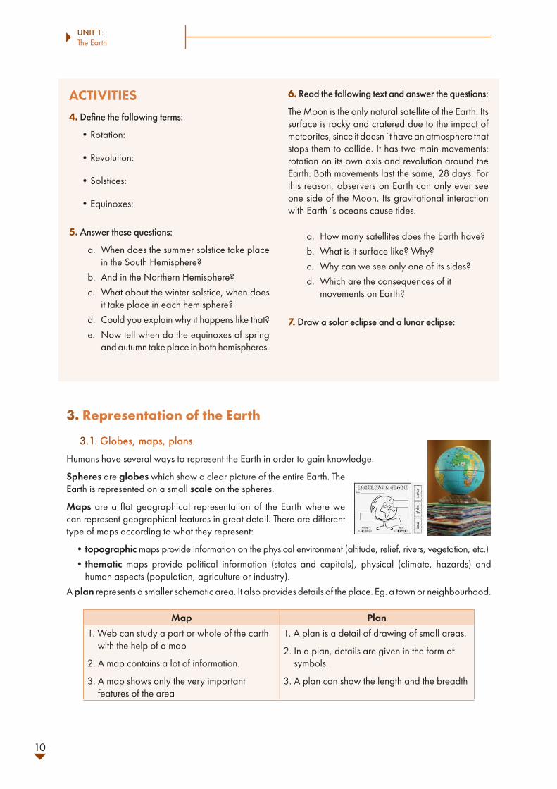
Spheres are globes which show a clear picture of the entire Earth. The Earth is represented on a small scale on the spheres.
Maps are a flat geographical representation of the Earth where we can represent geographical features in great detail. There are different type of maps according to what they represent:
• topographic maps provide information on the physical environment (altitude, relief, rivers, vegetation, etc.)• thematic maps provide political information (states and capitals), physical (climate, hazards) and
human aspects (population, agriculture or industry).A plan represents a smaller schematic area. It also provides details of the place. Eg. a town or neighbourhood.
Map Plan1. Web can study a part or whole of the carth
with the help of a map
2. A map contains a lot of information.
3. A map shows only the very important features of the area
1. A plan is a detail of drawing of small areas.
2. In a plan, details are given in the form of symbols.
3. A plan can show the length and the breadth

GEOGRAPHY AND HISTORY 1ST ESO BILINGUAL LEARNING
11
These representations must have at least one type of geographic scale, which is a proportional representation of the surface of the Earth, since we represent large areas in a much smaller format. There a two type of scales:
• graphic scale, where a segment indicates the proportion between the real length and the represented one. Since it appears draw, it would still be valid if we amplified or reduced the map (its size would vary in the same proportion as the rest of the representation):
• numeric scale, which indicates using a division the proportion between the length represented and the real length. It wouldn´t be valid if we change the map proportions. Eg. 1: 10000, 1: 250000
3.2. Latitude and longitude
The parallels and the meridians are imaginary lines which form a network. They allow us to situate any point on Earth via longitude and latitude.
The parallels are imaginary rings which circle the Earth from East to West, parallel to the Equator (parallel reference). The Equator divides the Earth into two hemispheres of equal size: the North (N) and the South (S). Latitude is the distance from any point on Earth to the Equator.
The meridians are imaginary lines which connect the poles in a North-South direction. The prime meridian is Greenwich (Great Britain). It divides the Earth on West (W) and East (E). Longitude is the distance from any point on Earth to the Greenwich meridian.
Both latitude and longitude are measured in degrees, followed by the letters N, S, W, or E, depending on the hemisphere or side of the prime meridian.
ACTIVITIES8. Complete the following text:
By using the Equator we can divide the world into two ________: northern and ________. If we use the prime ________, we can divide the world into ______ and West. Spain is in the ________ hemisphere and it is _______ of the prime ________.
9. At which longitude is Madrid located? You need to look in a map to answer this question.
10. On a map, the distance between two towns is 1 cm. What would the real distance be in meters if the scale of the map is:
a. 1:25 000: b. 1:30 000: c. 1:250 000:
11. Correct these sentences:
a. Small scale maps are used to show small areas of the Earth.
b. Longitude is the distance between any point of the Earth’s surface and the Equator.
c. Thematic maps are representations of relief, rivers, vegetation, etc.
d. The prime meridian is located in the Equator.