marcel negret portfolio 2015
TRANSCRIPT

Marcel NegretPortfolio 2015

Content
ii
1. The Soundview Waterfront Greenway
2. Open Space Index for NYC Rezonings
3. Coastal Green Infrastructure for Westchester Creek
4. Energy Savings through Cogeneration in New York City Housing Authority Developments
5. Integrating Renewable Energy into NYCHA Developments: Coney Island Case Study
6. Accounting for the Impact of Green Infrastructure, Framework for a Economic Valuation in NYC
7. Bushwick: Bright Green Future
8. NYC Survey on Recreational Boating
9. Population Health and Open Space in the Bronx
10. East Bronx Vulnerable Shorelines
11. Spontaneous Urban Plants: Interactive map and Website Design
12. Parking Lot Stormwater Retrofit
13. Green Roofs in NYC
14. North Hall Green Roof Monitoring Plan
15. Reimagining SoHo square
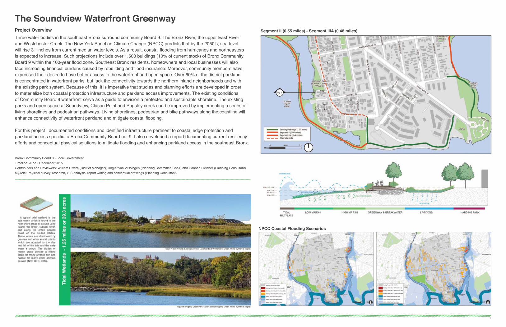
The Soundview Waterfront GreenwayProject OverviewThree water bodies in the southeast Bronx surround community Board 9: The Bronx River, the upper East River and Westchester Creek. The New York Panel on Climate Change (NPCC) predicts that by the 2050’s, sea level will rise 31 inches from current median water levels. As a result, coastal flooding from hurricanes and northeasters is expected to increase. Such projections include over 1,500 buildings (10% of current stock) of Bronx Community Board 9 within the 100-year flood zone. Southeast Bronx residents, homeowners and local businesses will also face increasing financial burdens caused by rebuilding and flood insurance. Moreover, community members have expressed their desire to have better access to the waterfront and open space. Over 60% of the district parkland is concentrated in waterfront parks, but lack the connectivity towards the northern inland neighborhoods and with the existing park system. Because of this, it is imperative that studies and planning efforts are developed in order to materialize both coastal protection infrastructure and parkland access improvements. The existing conditions of Community Board 9 waterfront serve as a guide to envision a protected and sustainable shoreline. The existing parks and open space at Soundview, Clason Point and Pugsley creek can be improved by implementing a series of living shorelines and pedestrian pathways. Living shorelines, pedestrian and bike pathways along the coastline will enhance connectivity of waterfront parkland and mitigate coastal flooding.
For this project I documented conditions and identified infrastructure pertinent to coastal edge protection and parkland access specific to Bronx Community Board no. 9. I also developed a report documenting current resiliency efforts and conceptual physical solutions to mitigate flooding and enhancing parkland access in the southeast Bronx.
Bronx Community Board 9 - Local GovernmentTimeline: June - December 2015Contributors and Reviewers: William Rivera (District Manager), Rogier van Vlissingen (Planning Committee Chair) and Hannah Fleisher (Planning Consultant)My role: Physical survey, research, GIS analysis, report writing and conceptual drawings (Planning Consultant)
NPCC Coastal Flooding Scenarios
Segment II (0.55 miles) - Segment IIIA (0.48 miles)
1

Open Space Index for NYC RezoningsProject OverviewIn face of the recent neighborhood rezoning studies, New Yorkers for Parks conducted an Open Space Index for the announced geographies. During fall of 2015, I developed a geographical information systems (GIS) methodology to measure open space indicators in the announced neighborhoods. The goal was to provide datasets and indicators related to Open Space that will contribute to an informed discussion between city agencies and community groups. Based on 15 specific standards, the Open Space Index provides indicators for a specific geography or neighborhood. Such standards are grouped in four categories: - Amount of Open Space in relation to population (for both passive and active recreation)- Access and Distance to Parks (population within walking distance to a park)- Environmental Sustainability (tree canopy and permeable surfacing)- Park Maintenance (cleanliness and overall maintenance)
Preliminary results were quantified and visualized in a interactive story map. GIS analysis can be visualized at the following online interactive map: www.arcg.is/1P8hCEM
The GIS analysis can be replicated for future or unannounced rezoning studies in the city. I was assigned to document the methodology in a set of detailed instructions that would enable staff and other organizations to reproduce the analysis.
New Yorkers for Parks - Non profit organizationTimeline: September - December 2015Reviewers: Beth Bingham (Director of Planning and Research) and Lucy Robson (Planning and Research Analyst)My role: GIS analysis, research, report writing and development of interactive story maps (Research and GIS Graduate Intern)
2
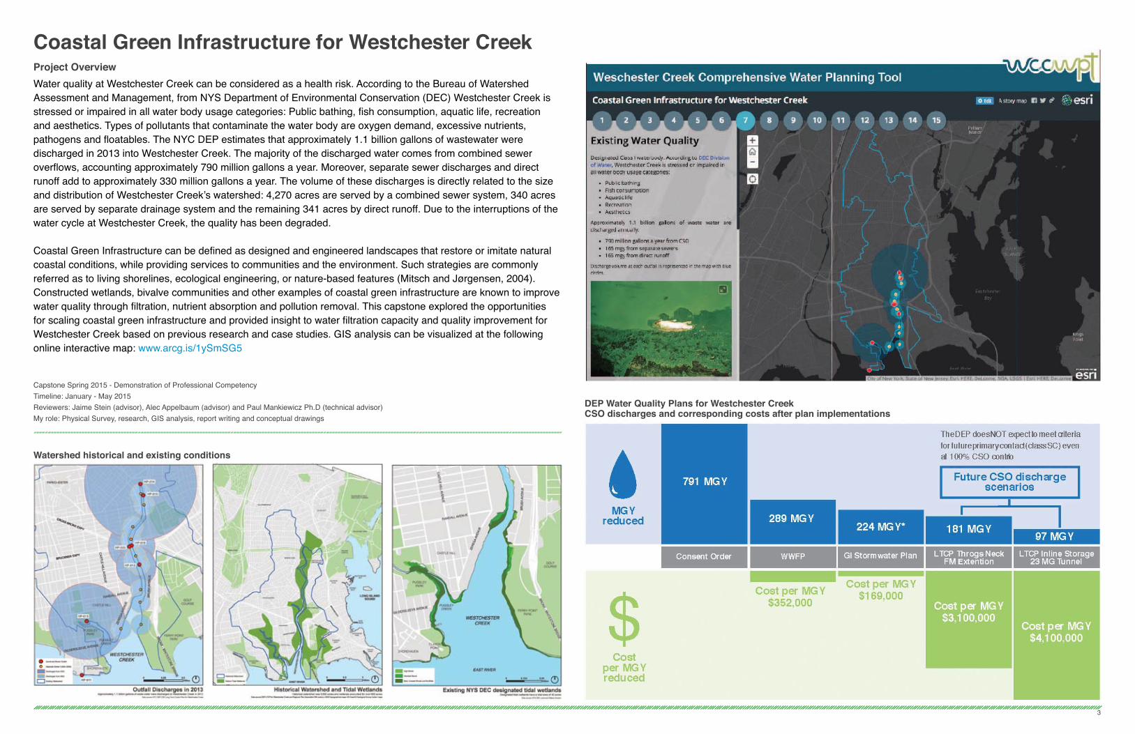
Coastal Green Infrastructure for Westchester CreekProject OverviewWater quality at Westchester Creek can be considered as a health risk. According to the Bureau of Watershed Assessment and Management, from NYS Department of Environmental Conservation (DEC) Westchester Creek is stressed or impaired in all water body usage categories: Public bathing, fish consumption, aquatic life, recreation and aesthetics. Types of pollutants that contaminate the water body are oxygen demand, excessive nutrients, pathogens and floatables. The NYC DEP estimates that approximately 1.1 billion gallons of wastewater were discharged in 2013 into Westchester Creek. The majority of the discharged water comes from combined sewer overflows, accounting approximately 790 million gallons a year. Moreover, separate sewer discharges and direct runoff add to approximately 330 million gallons a year. The volume of these discharges is directly related to the size and distribution of Westchester Creek’s watershed: 4,270 acres are served by a combined sewer system, 340 acres are served by separate drainage system and the remaining 341 acres by direct runoff. Due to the interruptions of the water cycle at Westchester Creek, the quality has been degraded.
Coastal Green Infrastructure can be defined as designed and engineered landscapes that restore or imitate natural coastal conditions, while providing services to communities and the environment. Such strategies are commonly referred as to living shorelines, ecological engineering, or nature-based features (Mitsch and Jørgensen, 2004).Constructed wetlands, bivalve communities and other examples of coastal green infrastructure are known to improve water quality through filtration, nutrient absorption and pollution removal. This capstone explored the opportunities for scaling coastal green infrastructure and provided insight to water filtration capacity and quality improvement for Westchester Creek based on previous research and case studies. GIS analysis can be visualized at the following online interactive map: www.arcg.is/1ySmSG5
Capstone Spring 2015 - Demonstration of Professional CompetencyTimeline: January - May 2015Reviewers: Jaime Stein (advisor), Alec Appelbaum (advisor) and Paul Mankiewicz Ph.D (technical advisor)My role: Physical Survey, research, GIS analysis, report writing and conceptual drawings
Watershed historical and existing conditions
DEP Water Quality Plans for Westchester CreekCSO discharges and corresponding costs after plan implementations
3

4
Energy Savings Through Cogeneration in New York City Housing Authority DevelopmentsProject OverviewManagers and residents of the New York Housing Authority developments realize the importance of implementing energy efficiency measures not only in the context of climate change, but for the fiscal health of the city’s housing system. NYCHA buildings are good candidates for Combined Heat and Power due to the large electric loads they demand and the centralized master meters that measure the system. Several cases of multifamily buildings in New York City show the effectiveness of this Energy Efficiency measure: Chelsea’s Penn South co-op in Manhattan saw $1.5 million in savings, and the North Shore Towers in Queens reported savings of $750,000 annually from co-generation power over the past 30 years. In the case of NYCHA, additional benefits could be considered if a bulk negotiation is reached with technology providers. The 2,563 building stock from NYCHA offers significant opportunities for economies of scale by lowering costs and increasing efficiency in operations. This academic project explored the role of multiple stakeholders and explored strategies for CHP implementation. Discussions, in which students represented stakeholder’s roles, simulated the importance of facilitation and provided insights of potential implementation strategies.
Pratt PSPD Course - Urban Energy ManagementTimeline: January - May 2014Reviewer: Michael Bobker (Adjunt Professor)Team: Horacio Alvear, Erin Buchanan, Josh Eichen and Korin TangtrakulMy role: Research, graphic design and report writing on NYPA’s role

Integrating Renewable Energy into NYCHADevelopments: Coney Island Case StudyProject OverviewAfter Superstorm Sandy hit New York, many buildings were left without electricity due to damage on the electric grid. As described by the Green Building Council report “Lack of electricity after Superstorm Sandy was a bigger problem for many people than the storm itself, affecting 20 percent of New Yorkers.” (Building resiliency task force, 2013). It is desirable to have backup electricity generation systems in emergency scenarios. Renewables are a good candidate since they don’t require fuel and can be easily integrated into buildings. Furthermore, most renewable technologies are well suited for off grid conditions and appropriate for areas with poor electric infrastructure.
This paper explores solar and wind based technologies and the potential impact they could have in New York City public housing. We determined possible scenarios and design strategies for energy reduction for a specific NYCHA building in Coney Island Brooklyn, NY. By using Sefaira, a performanced based design software, I quantified production scenarios and determined possible energy savings/production.
Pratt PSPD Course - Retrofitting existing buildingsTimeline: August - November 2013Reviewer: Gita Nandan RA (Adjunct Professor)My role: Building surveying, 3D modeling, Sefaira energy modeling and report writing
5
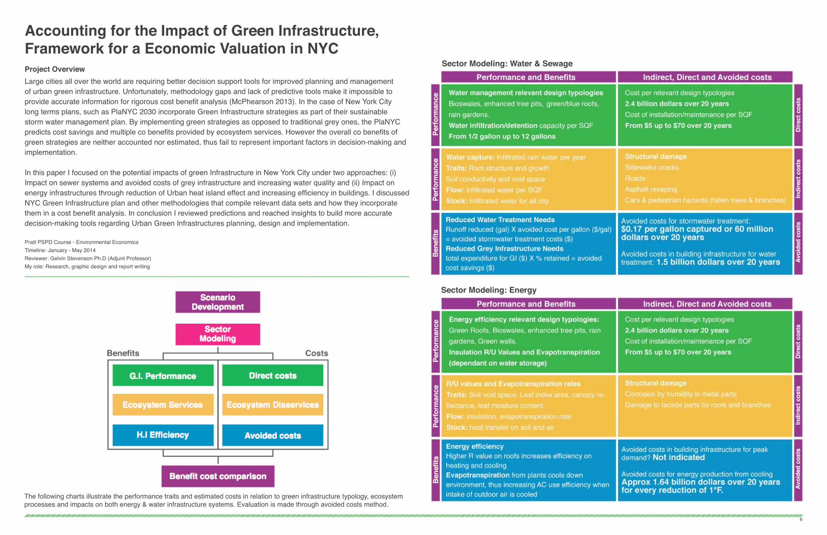
Accounting for the Impact of Green Infrastructure, Framework for a Economic Valuation in NYCProject OverviewLarge cities all over the world are requiring better decision support tools for improved planning and management of urban green infrastructure. Unfortunately, methodology gaps and lack of predictive tools make it impossible to provide accurate information for rigorous cost benefit analysis (McPhearson 2013). In the case of New York City long terms plans, such as PlaNYC 2030 incorporate Green Infrastructure strategies as part of their sustainable storm water management plan. By implementing green strategies as opposed to traditional grey ones, the PlaNYC predicts cost savings and multiple co benefits provided by ecosystem services. However the overall co benefits of green strategies are neither accounted nor estimated, thus fail to represent important factors in decision-making and implementation.
In this paper I focused on the potential impacts of green Infrastructure in New York City under two approaches: (i) Impact on sewer systems and avoided costs of grey infrastructure and increasing water quality and (ii) Impact on energy infrastructures through reduction of Urban heat island effect and increasing efficiency in buildings. I discussed NYC Green Infrastructure plan and other methodologies that compile relevant data sets and how they incorporate them in a cost benefit analysis. In conclusion I reviewed predictions and reached insights to build more accurate decision-making tools regarding Urban Green Infrastructures planning, design and implementation.
Pratt PSPD Course - Environmental EconomicsTimeline: January - May 2014Reviewer: Gelvin Stevenson Ph.D (Adjunt Professor)My role: Research, graphic design and report writing
Sector Modeling: Water & Sewage
The following charts illustrate the performance traits and estimated costs in relation to green infrastructure typology, ecosystem processes and impacts on both energy & water infrastructure systems. Evaluation is made through avoided costs method.
Sector Modeling: Energy
6
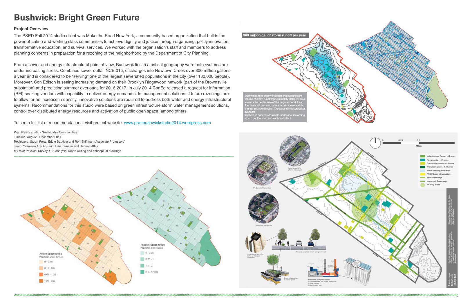
Bushwick: Bright Green FutureProject OverviewThe PSPD Fall 2014 studio client was Make the Road New York, a community-based organization that builds the power of Latino and working class communities to achieve dignity and justice through organizing, policy innovation, transformative education, and survival services. We worked with the organization’s staff and members to address planning concerns in preparation for a rezoning of the neighborhood by the Department of City Planning.
From a sewer and energy infrastructural point of view, Bushwick lies in a critical geography were both systems are under increasing stress. Combined sewer outfall NCB 015, discharges into Newtown Creek over 300 million gallons a year and is considered to be “serving” one of the largest sewershed populations in the city (over 180,000 people). Moreover, Con Edison is seeing increasing demand on their Brooklyn Ridgewood network (part of the Brownsville substation) and predicting summer overloads for 2016-2017. In July 2014 ConEd released a request for information (RFI) seeking vendors with capability to deliver energy demand side management solutions. If future rezonings are to allow for an increase in density, innovative solutions are required to address both water and energy infrastructural systems. Recommendations for this studio were based on green infrastructure storm water management solutions, control over distributed energy resources and activation of public open space, among others.
To see a full list of recommendations, visit project website: www.prattbushwickstudio2014.wordpress.com
Pratt PSPD Studio - Sustainable CommunitiesTimeline: August - December 2014Reviewers: Stuart Pertz, Eddie Bautista and Ron Shiffman (Associate Professors)Team: Yasmeen Abu Al Saud, Lise Lamatia and Hannah AtlasMy role: Physical Survey, GIS analysis, report writing and conceptual drawings
7
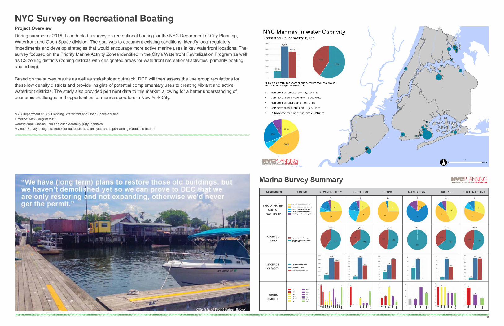
NYC Survey on Recreational BoatingProject OverviewDuring summer of 2015, I conducted a survey on recreational boating for the NYC Department of City Planning, Waterfront and Open Space division. The goal was to document existing conditions, identify local regulatory impediments and develop strategies that would encourage more active marine uses in key waterfront locations. The survey focused on the Priority Marine Activity Zones identified in the City’s Waterfront Revitalization Program as well as C3 zoning districts (zoning districts with designated areas for waterfront recreational activities, primarily boating and fishing).
Based on the survey results as well as stakeholder outreach, DCP will then assess the use group regulations for these low density districts and provide insights of potential complementary uses to creating vibrant and active waterfront districts. The study also provided pertinent data to this market, allowing for a better understanding of economic challenges and opportunities for marina operators in New York City.
NYC Department of City Planning, Waterfront and Open Space divisionTimeline: May - August 2015Contributors: Jessica Fain and Allan Zaretsky (City Planners)My role: Survey design, stakeholder outreach, data analysis and report writing (Graduate Intern)
8
9
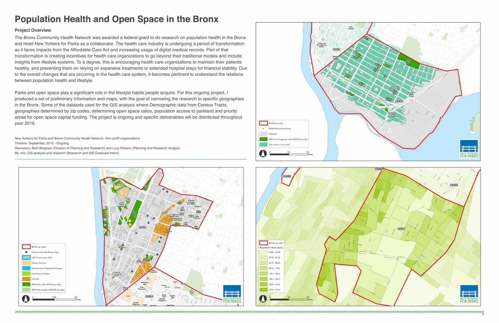
Population Health and Open Space in the BronxProject OverviewThe Bronx Community Health Network was awarded a federal grant to do research on population health in the Bronx and hired New Yorkers for Parks as a collaborator. The health care industry is undergoing a period of transformation as it faces impacts from the Affordable Care Act and increasing usage of digital medical records. Part of that transformation is creating incentives for health care organizations to go beyond their traditional models and include insights from lifestyle systems. To a degree, this is encouraging health care organizations to maintain their patients healthy, and preventing them on relying on expensive treatments or extended hospital stays for financial stability. Due to the overall changes that are occurring in the health care system, it becomes pertinent to understand the relations between population health and lifestyle.
Parks and open space play a significant role in the lifestyle habits people acquire. For this ongoing project, I produced a set of preliminary information and maps, with the goal of narrowing the research to specific geographies in the Bronx. Some of the datasets used for the GIS analysis where Demographic data from Census Tracts, geographies determined by zip codes, determining open space ratios, population access to parkland and priority areas for open space capital funding. The project is ongoing and specific deliverables will be distributed throughout year 2016.
New Yorkers for Parks and Bronx Community Health Network- Non profit organizationsTimeline: September, 2015 - OngoingReviewers: Beth Bingham (Director of Planning and Research) and Lucy Robson (Planning and Research Analyst)My role: GIS analysis and research (Research and GIS Graduate Intern)

East Bronx Vulnerable ShorelinesProject OverviewAfter Hurricane Sandy, the City of New York initiated multiple efforts to improve its resiliency: comprehensive planning and reports such as the Stronger more resilient New York (SIRR) have been produced and over $4 billion dollars where awarded by the Department of Housing and Urban Development (HUD) through the Community Development Block Grant Disaster Recovery program (CDBG-DR). However, such efforts have not been equally developed throughout the city. Many water bound and vulnerable communities, such as Bronx Community Board 10, have been ignored with little to no participation in these important planning processes.
During fall of 2014, I physically surveyed over 20 miles of shorelines in the east Bronx. Extensive photographic documentation was made available through social media. Moreover a GIS analysis provided relevant data in favor of feasibility studies and implementation of costal protection strategies. Furthermore, I categorized coastal infrastructure typologies and made a preliminary analysis of their potential extent and locations.
Fund for the City of New York - Bronx Community Board 10Timeline: September 2014 - May, 2015Rreviewers: Paul Mankiewicz Ph.D (Advisor) and Kenneth Kearns (District Manager)My role: Physical survey, research, report writing and concept drawings (Community Planning Fellow)
10

Spontaneous Urban Plants: Interactive Map and Website DesignProject OverviewAlthough we tend to think of our cities as concrete jungles, our post-new urban environment is awash in plant life. Spontaneously propagating, resilient plants find distinctive niches to thrive in and inhabit our most derelict landscapes. Spontaneous Urban Plants (SUP) is a research project that investigates the role of weeds in the urban ecosystem. Leveraging principles of urban ecology and environmental aesthetics, the project encourages an objective debate of the value of wild urban plants and thereby challenging contemporary cultural perceptions.
The project invites members of the public interact with the weeds by traversing urban spaces on foot and documenting their findings through social media application Instagram. This allows us to consider the aesthetic value of the environment from the individual’s perspective through immediate and hands-on experience. The Interactive MAP filters photos by species or performance attributes, thus highlighting SUP’s ecological, cultural, and aesthetic significance.
For this project I documented academic research on urban ecology related to exotic species. I also supported the team in providing deliverables and mock ups for the website development. I also coordinated with the website developer in order to obtain quotes and meet deadlines.
Recipient of an ASLA Research Honor Award 2015 (American Society of Landscape Architects)For more information visit: www.spontaneousurbanplants.org
Future Green Studio - Landscape Design and Build FirmTimeline: January - August 2014Team: David Seiter RLA (Principal) and Lois Farningham (Associate Designer)My role: Academic research, user experience mockups, website structure and backend maintenace (Design Research Assistant)
11
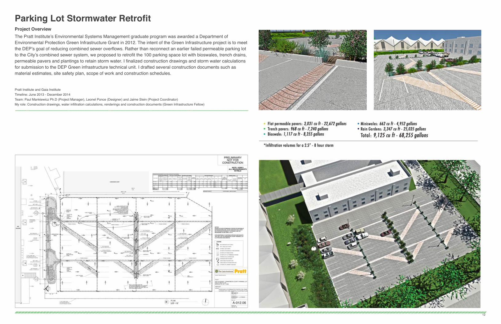
Parking Lot Stormwater RetrofitProject OverviewThe Pratt Institute’s Environmental Systems Management graduate program was awarded a Department of Environmental Protection Green Infrastructure Grant in 2012. The intent of the Green Infrastructure project is to meet the DEP’s goal of reducing combined sewer overflows. Rather than reconnect an earlier failed permeable parking lot to the City’s combined sewer system, we proposed to retrofit the 100 parking space lot with bioswales, trench drains, permeable pavers and plantings to retain storm water. I finalized construction drawings and storm water calculations for submission to the DEP Green infrastructure technical unit. I drafted several construction documents such as material estimates, site safety plan, scope of work and construction schedules.
Pratt Institute and Gaia InstituteTimeline: June 2013 - December 2014Team: Paul Mankiewicz Ph.D (Project Manager), Leonel Ponce (Designer) and Jaime Stein (Project Coordinator)My role: Construction drawings, water infiltration calculations, renderings and construction documents (Green Infrastructure Fellow)
12

Green Roofs in NYCProject OverviewHighview Creations specializes in design, installation, and maintenance of green roofs in New York City. The company develops customized green roof systems based on the specific needs of the client. Most of the projects I participated, where designed to capture storm water and applied for funding through the Department of Environmental Protection Green Infrastructure grants. Between June and December of 2015 I have provided conceptual designs and preliminary construction documents for over half a dozen green roof projects. Project surface area range between 5,000 and 40,000 square feet.
High View Creations - Landscape Design and Build FirmTimeline: June - December 2015Team: Eric Dalski, Erik Facteau and Mark DalskiMy role: Construction drawings, water infiltration calculations, renderings and construction documents (Design consultant)
13
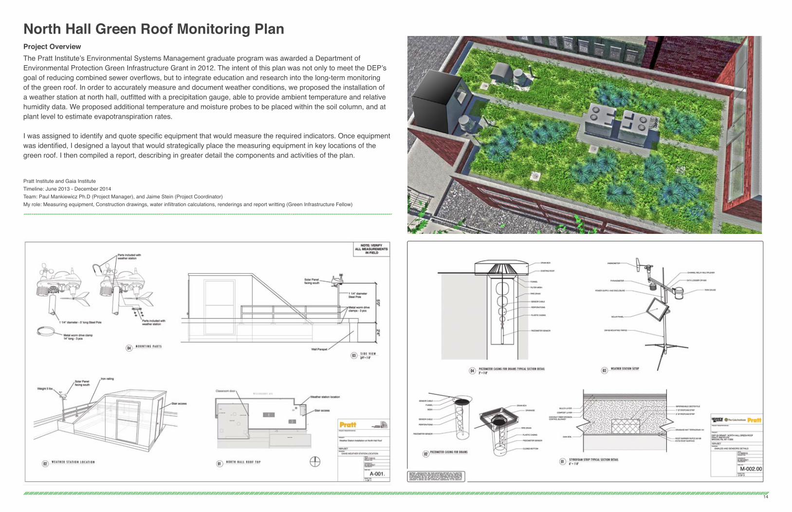
North Hall Green Roof Monitoring PlanProject OverviewThe Pratt Institute’s Environmental Systems Management graduate program was awarded a Department of Environmental Protection Green Infrastructure Grant in 2012. The intent of this plan was not only to meet the DEP’s goal of reducing combined sewer overflows, but to integrate education and research into the long-term monitoring of the green roof. In order to accurately measure and document weather conditions, we proposed the installation of a weather station at north hall, outfitted with a precipitation gauge, able to provide ambient temperature and relative humidity data. We proposed additional temperature and moisture probes to be placed within the soil column, and at plant level to estimate evapotranspiration rates.
I was assigned to identify and quote specific equipment that would measure the required indicators. Once equipment was identified, I designed a layout that would strategically place the measuring equipment in key locations of the green roof. I then compiled a report, describing in greater detail the components and activities of the plan.
Pratt Institute and Gaia InstituteTimeline: June 2013 - December 2014Team: Paul Mankiewicz Ph.D (Project Manager), and Jaime Stein (Project Coordinator)My role: Measuring equipment, Construction drawings, water infiltration calculations, renderings and report writting (Green Infrastructure Fellow)
14

Reimagining SoHo SquareProject OverviewAs part of the Hudson Square Connection and the business improvement district (BID), capital funding was allocated to enhance public spaces in the area. SoHo square serves a sizable residential, student and working population. Because of this, a sizable portion of the BID funding was aimed to the square. This academic exercise explores principles of open space design and proposes use of innovative technologies for storm water management and public space activation.
Pratt PSPD Course - Open Space Design and PlanningTimeline: August - October 2014Reviewer: Siegne Nielsen RLA (Associate Proffessor)My role: Research, conceptual design and 3D modeling
15

Marcel NegretPortfolio 2015