mar 20070014: ells rivercontent.energy.alberta.ca/xdata/mars/mar_20070014.pdf · downloading of the...
TRANSCRIPT

MAR 20070014: ELLS RIVER Received date: May 16, 2007 Public release date: Jun 25, 2008 DISCLAIMER By accessing and using the Alberta Energy website to download or otherwise obtain a scanned mineral assessment report, you (“User”) agree to be bound by the following terms and conditions: a) Each scanned mineral assessment report that is downloaded or otherwise obtained from Alberta
Energy is provided “AS IS”, with no warranties or representations of any kind whatsoever from Her Majesty the Queen in Right of Alberta, as represented by the Minister of Energy (“Minister”), expressed or implied, including, but not limited to, no warranties or other representations from the Minister, regarding the content, accuracy, reliability, use or results from the use of or the integrity, completeness, quality or legibility of each such scanned mineral assessment report;
b) To the fullest extent permitted by applicable laws, the Minister hereby expressly disclaims, and is released from, liability and responsibility for all warranties and conditions, expressed or implied, in relation to each scanned mineral assessment report shown or displayed on the Alberta Energy website including but not limited to warranties as to the satisfactory quality of or the fitness of the scanned mineral assessment report for a particular purpose and warranties as to the non-infringement or other non-violation of the proprietary rights held by any third party in respect of the scanned mineral assessment report;
c) To the fullest extent permitted by applicable law, the Minister, and the Minister’s employees and agents, exclude and disclaim liability to the User for losses and damages of whatsoever nature and howsoever arising including, without limitation, any direct, indirect, special, consequential, punitive or incidental damages, loss of use, loss of data, loss caused by a virus, loss of income or profit, claims of third parties, even if Alberta Energy have been advised of the possibility of such damages or losses, arising out of or in connection with the use of the Alberta Energy website, including the accessing or downloading of the scanned mineral assessment report and the use for any purpose of the scanned mineral assessment report so downloaded or retrieved.
d) User agrees to indemnify and hold harmless the Minister, and the Minister’s employees and agents against and from any and all third party claims, losses, liabilities, demands, actions or proceedings related to the downloading, distribution, transmissions, storage, redistribution, reproduction or exploitation of each scanned mineral assessment report obtained by the User from Alberta Energy.
Alberta Mineral Assessment Reporting System
MAY 16 2007 200-)00 4
1
GRAYMONT WESTERN CANADA INC.
2006 EXPLORATION AT THE ELLS RIVER METALLIC AND INDUSTRIAL MINERALS PERMITS,
NORTHERN ALBERTA
PART B
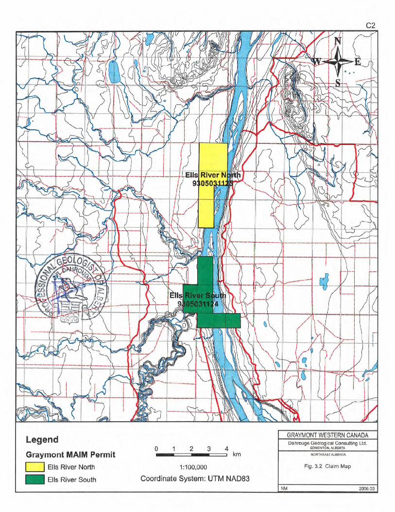
Metallic and Industrial Minerals Permits: 9305031124 and 9305031125
Geographic Coordinates
570 17' N to 57 023' N 111 038' Wto 111 °42'W
NTS Sheet 74 E15
Owner of MAIM Permits 9305031124 and 9305031125 Graymont Western Canada Inc. 190, 3025- 12 Street N.E. Calgary, AB, T2E 7J2
Operator: Graymont Western Canada Inc. 190, 3025- 12 Street N.E. Calgary, AB, T2E 7J2
Consultant: Dahrouge Geological Consulting Ltd. 18,10509-81 Avenue Edmonton, Alberta T6E 1X7
Authors: J. Dahrouge, B.Sc., P.Geol. P. Kluczny, B.Sc., GeoLI.T.
Date Submitted: May 15, 2007
2
TABLE OF CONTENTS Page
1. Summary . 4
2. Introduction 4
3. Location and Access ................................................ 4
4. Work Performed
5
5. Results 5
6. Conclusions 6
7. References 7
8. Statement of Author
8
LIST OF TABLES
Table 1.2 Allocation of Expenditures ....................................4
3
PART C
LIST OF FIGURES Pacie
Fig. 3.1 Location Map ................................................Cl Fig. 3.2 Claim Map ................................................C2 Fig. 3.3 Location of Work ..............................................C3
LIST OF APPENDICES
Appendix 1: Cost Statement for the 2006 Exploration .........................C4
4
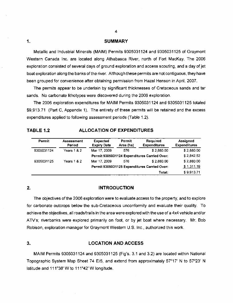
1. SUMMARY
Metallic and Industrial Minerals (MAIM) Permits 9305031124 and 9305031125 of Graymont
Western Canada Inc. are located along Athabasca River, north of Fort MacKay. The 2006
exploration consisted of several days of ground exploration and access scouting, and a day of jet
boat exploration along the banks of the river. Although these permits are not contiguous, they have
been grouped for convenience after obtaining permission from Hazer Henson in April, 2007.
The permits appear to be underlain by significant thicknesses of Cretaceous sands and tar
sands. No carbonate lithotypes were discovered during the 2006 exploration.
The 2006 exploration expenditures for MAIM Permits 9305031124 and 9305031125 totaled
$9,913.71 (Part C, Appendix 1). The entirety of these permits will be retained and the excess
expenditures applied to following assessment periods (Table 1.2).
TABLE 1.2
Permit
9305031124
9305031125
2.
ALLOCATION OF EXPENDITURES
Assessment Expected Permit Required Period Expiry Date Area (ha) Expenditures
Years 1 & 2 Mar 17, 2009 576 $ 2,880.00
Permit 9305031124 Expenditures Carried Over:
Years 1 & 2 Mar 17, 2009 576 $ 2,880.00
Permit 9305031125 Expenditures Carried Over:
Total:
INTRODUCTION
Assigned Expenditures
$ 2,880.00
$ 2,842.52
$ 2,880.00
$1,311.19
$ 9,913.71
The objectives of the 2006 exploration were to evaluate access to the property, and to explore
for carbonate outcrops below the sub-Cretaceous unconformity and evaluate their quality. To
achieve the objectives, all roads/trails in the area were explored with the use of a 44 vehicle and/or
ATV's; riverbanks were explored primarily on foot, or by jet boat where necessary. Mr. Bob
Robison, exploration manager for Graymont Western U.S. Inc., authorized this work.
3. LOCATION AND ACCESS
MAIM Permits 9305031124 and 9305031125 (Fig's. 3.1 and 3.2) are located within National
Topographic System Map Sheet 74 E/5, and extend from approximately 57°17' N to 57°23' N
latitude and 11 1 038'W to 11 1 042'W longitude.

5
The MAIM permits encompass an area about 15 km north of Fort Mackay, within northeastern
Alberta. Fort Mackay is about 55 km west of the Alberta-Saskatchewan border and 60 km north
of Fort McMurray, which is accessible by a 437 km paved highway from Edmonton. The southern
permit, 9305031124, is accessible by a public all-weather gravel road running north from Fort
MacKay. The northern permit, 9305021125, can potentially be accessed by a few roads/trails;
however, all access to the area is restricted by Canadian Natural Resources Limited (CNRL) due
to the ongoing development of their Horizon Oil Sands Project. This access could not be utilized
at the time of exploration; the permit was primarily explored utilizing a jet boat on Athabasca River.
4. WORK PERFORMED
The geological work on the Firebag River permits was conducted by Dahrouge Geological
Consulting Ltd. (Dahrouge) on behalf of Graymont Western Canada Inc. (Graymont).
From September 251h to October 2006, trails and riverbanks within and around MAIM
permits 9305031124 and 9305031125 were explored utilizing a 4x4 truck and ATV's where
possible, and by foot or jet boat where necessary (Fig. 4.1). Time was spent evaluating access to
the property as well as attempting to locate any carbonate outcrops.
5. RESULTS
Access to the southern permit (MAIM Permit 9305031124) is abundant and of high-quality, as
the gravel road running north of Fort Mackay intersects the permit. There are also several smaller
trails and cut-lines that can be utilized with ATV's to access different parts of the permit. No
carbonate outcrops were discovered within the permit during ground or jet boat exploration. Only
Cretaceous sands and tar sands were encountered.
The northern permit (MAIM Permit 9305031125) is not easily accessed by land. Any
roads/trails in the area are restricted by CNRL, as the area is within their Horizon Oil Sands Project.
It is possible to reach the claims on foot from the most northerly road access, but this involves
several hours of hiking through thick brush. Ajet boat was used to scour the banks of Athabasca
River for carbonate outcrops; however, none were discovered. Similarly, only sands and tar sands
were encountered in the northern permit.
6
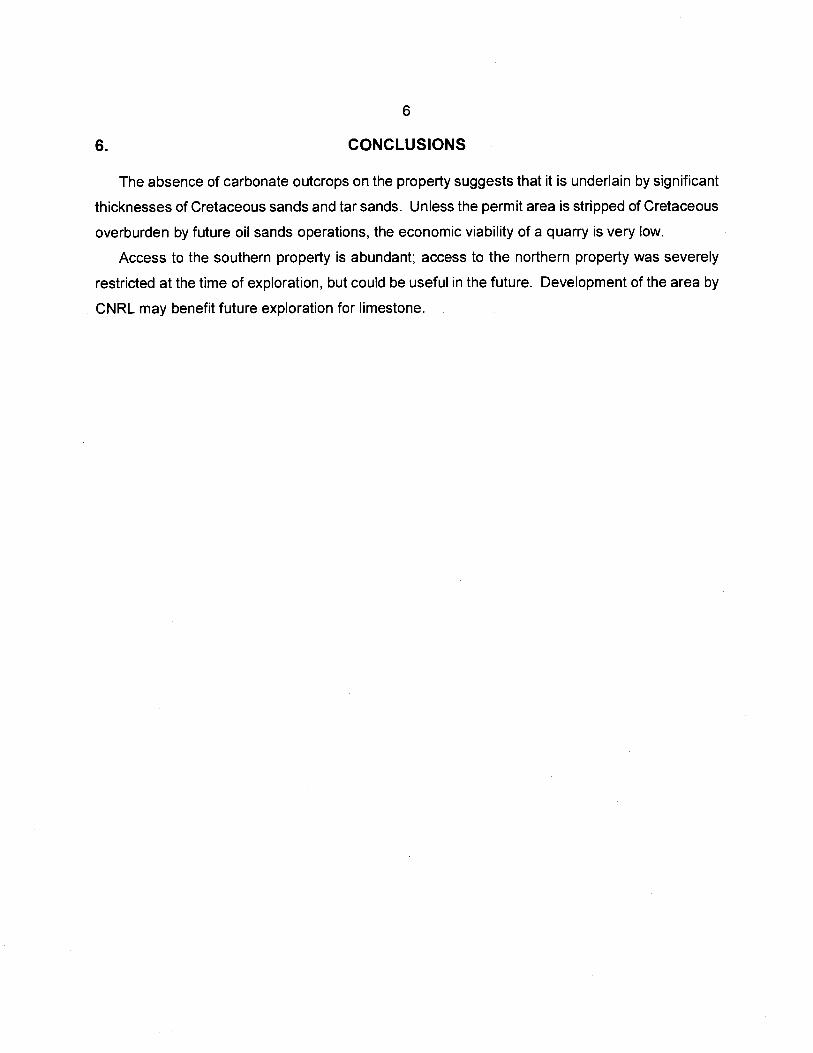
6. CONCLUSIONS
The absence of carbonate outcrops on the property suggests that it is underlain by significant
thicknesses of Cretaceous sands and tar sands. Unless the permit area is stripped of Cretaceous
overburden by future oil sands operations, the economic viability of a quarry is very low.
Access to the southern property is abundant; access to the northern property was severely
restricted at the time of exploration, but could be useful in the future. Development of the area by
CNRL may benefit future exploration for limestone

7
7. REFERENCES
Dahrouge, J.R. and Wolbaum, R. (2004) 2004 Exploration and Fieldwork for High-Quality Carbonates at the Pierre River Permit, near Fort McKay, Northeast Alberta; ass. rept. for Graymont Western Canada Inc., Dahrouge Geological Consulting Ltd., Edmonton, 15 p.
Norris, A.W. (1963) Devonian Stratigraphy of Northeastern Alberta and Northwestern Saskatchewan; Geol. Surv. Can., Mem 313.

8
STATEMENT OF AUTHOR
I, Jody Dahrouge, residing at 11 Country Lane, Stony Plain, Alberta, do hereby certify that:
§ I am a geologist of Dahrouge Geological Consulting Ltd., Suite 18, 10509 - 81 Ave, Edmonton, Alberta, T6E-1X7.
§ I am a graduate of the University of Alberta, Edmonton, Alberta with a B.Sc. in Geology, 1988 and a Special Certificate (Sp.C.) in Computing Science in 1994.
§ I have practiced my profession as a geologist intermittently from 1988 to 1994, and continuously since 1994.
§ I am a registered professional geologist with the Association of Professional Engineers, Geologists and Geophysicists of Alberta, member M48123.
§ I hereby consent to the copying or reproduction of this Technical Report following the one-year confidentiality period.
§ I am the author of the report entitled "2006 Exploration at the Ells River Metallic and Industrial Minerals Permits, Northeastern Alberta" and accept responsibility for the veracity of technical data and results.
Dated thi s(j1ay, 2007.
-1
JodyNW-1 APEGGA M4

Cl
CANADA
NORTHWEST TERRITO RIES
Fort ch DOr Chi
I Level Frae
L Lake rt emlilon laire
b rete Location of ro MAIM Permits
Manning
IA B Ac, rin,sha ( McM rray
eace iver ~Vvabasra
I Demar is rvew
Sp i rit .
River Lesser '
Hiyr
5f.vej. r Gra - Plrle Si P rle all lew Lake Lac L -
J)
PEr
)r N/ Creek
hefht
Hlnt7 (V C Draytc 1RJ
cky Mountel
LEGEND
Provincial capital
Other populated places Canmo
Trans-Canada Highway - anff ca I Major road
International boundary
Provincial boundary
lcF1 Cold 1 f 4
asca Lak
k orinyvEle St Paul I
kdtche 1
—G r vilte
Mon 0
uc Ca
Lloyd lrster mr
re Ft I r tj
Stettle rOv0St
1 Hanna
er Oyen
OeCr R
River Brooks
Medic e
a7 ft
rt ridge
M lye
..-. ..-
Scale 15 0 75 150 225
km I .. _I ___I I km
© 2004 Her Majesty the Queen n Right of Canada, Natural Resources Canada.
C2

45110fl 458000 460000 462000 464000
C3
462000 464000
- Ground Survey
- Jet Boat Survey
456000 458000 460000
0 0.5 1 2 3 KM I
1:50000
Coordinate System: (JTM NAD83
Q
0 0 0 0
0
0 0
0 0 0 0
C4
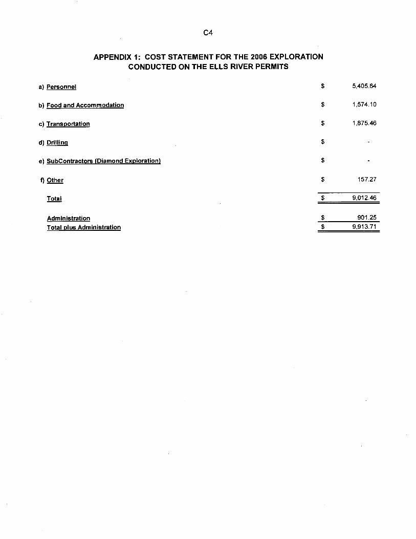
APPENDIX 1: COST STATEMENT FOR THE 2006 EXPLORATION CONDUCTED ON THE ELLS RIVER PERMITS
a) Personnel
$ 5,405.64
b) Food and Accommodation
$ 1,574.10
c) Transportation
$ 1,875.46
d) Drilling
$
e) SubContractors (Diamond Exploration)
$
f) Other
$ 157.27
Total
$ 9,012.46
Administration
$ 901.25
Total plus Administration
$ 9,913.71