maps and drawings of corfu in the library of the correr museum · maps and drawings of corfu in the...
TRANSCRIPT
e-Perimetron, Vol.1, No. 1, Winter 2006 [1-31] www.maplibrary.gr/e_perimetron | ISSN 1790-3769
Elisabetta Molteni*, Silvia Moretti**
Maps and drawings of Corfu in the Library of the Museo Correr***
Keywords: Alessandro Ganassa, Giovanni de Honstein, fortifications, Corfu maps, Jean Baptiste Homann, Museo Correr Venice, Duke of Savoia, Marcello Alessandri, Johann Mathias von Schulemburg, Moser de Filseck, Mili-
tary Hospital, port system of Spilea, port town of Govin, Padua.
Summary The maps of Corfu preserved in the Museo Correr of Venice (dated XVI-XVIII centuries) primarily record the fortifications of the Old City and its burghs, but also the urban configu-ration of the whole and of significant areas of the city is well represented (projects for the transformation of the Military Hospital and the port system of Spilea). Through the descrip-tion of each map (examined as a document in the catalogue) we attempted not just to write a short history of the fortifications of Corfu, but to highlight the contribution of cartography to the knowledge of the relationship between military architecture and urban history.
Introduction
The maps of Corfu presented here are the most interesting and significant of the ones pre-served at the Museo Correr in Venice1. These maps date from different periods, and are
The text and catalogue have been conceived together, although one can attribute to Ms Molte-ni paragraph 3 and catalog n. 1-5, to Ms Moretti paragraph 2, paragraph 4 and catalog n. 6-17. Translated in English by Olga Barmine. * Department of History of Arts and Conservation of Artistic Heritage "Giuseppe Mazzariol", University Ca' Foscari of Venice, Italy. [[email protected]] ** Department of Architecture, Town Planning and Surveying, Faculty of Engineering, University of Padua, Italy, [[email protected]] *** These notes are the result of a study conducted in 1999 that was firstly published in the CDRom Corfù. Immagini e documenti dalle collezioni storiche del Museo Correr, a cura di G. Romanelli e C. Tonini, Comune di Venezia, Musei civici veneziani, Centro Stampa - Centro Produzione Multimediale, Venezia 2000 (hereinafter CORFÙ 2000) and is now being presented in updated form thanks to new research studies for the exhibition entitled Navigare e Descrivere. Isolari e portolani del Museo Correr di Venezia, XV-XVIII secolo, curated by C. Tonini and P. Lucchi, Venezia, Museo Correr, December 1 2001- April 1 2002 (catalog edited by C. Tonini and P. Lucchi, Marsilio, Venezia 2001) and as part of the MURST project Iconografia delle città venete dal XV al XVIII secolo, directed by V. Fontana and developed in collaboration with the Museo Correr, the results of which have been published in the CDRom Struttura urbana e immagine della città nello Stato veneziano di Terraferma, ed. by V. Fontana, Università degli Studi di Napoli Federico II, Centro di Ricerca Iconografia della Città Europea, Università degli Studi di Venezia Ca’ Foscari, Dipartimento di Storia e Conservazione dei Beni Artistici G. Mazzariol, 2003. 1 Some engravings have been left out: Venezia, Biblioteca del Museo Correr (hereinafter BMC) Mss. Correr 1214, fasc. 2740/1, copy by Andrea Marmora, Historia di Corfù descritta da Andrea Marmora nobile corcirese. Libri otto, presso il Curti, Venetia 1672, pp. 364-365; Mss. Correr 1214, fasc. 2740/2, Pianta di Corfù, (published in Venezia by Gio. Antonelli at S. Aponal, a view of the stronghold with the Turkish and Christian fleets engaging combat in the waters before the city); Mss. Correr 1214, fasc. 2740/3, Pianta della Città e Fortezza di Corfù, consacrata al Serenissimo principe Giovanni Cornaro (printed by Domenico Lovisa and engraved by Zucchi. This map dedicated to Giovanni II Corner, as
[1]
made with different techniques on different supports; they primarily record the fortifica-tions of the Old City and its burghs and in some cases the urban configuration. From the eighteenth century, there are four representations of the city as a whole with part of the surrounding territory, three hand-drawn maps and an engraving: the most important map, heretofore unpublished2, dates back to 1753 and is the work of Giovanni de Honstein (Ar-chivio De Lazara, Pisani Zusto, cass. 1/12, fig. 7); the second, probably made shortly thereafter is dedicated to Andrea Tron (Mss.P.D. c. 842/5, fig. 8)3; the third, finally, (Mss. P.D., c.842/4, fig. 9) is attributed to Alessandro Ganassa, a cartographer working in Corfu after the 1780’s who was also the author of an interesting series of topographic drawings preserved at the Archives of the Prefecture in Corfu4. The group of eighteenth century representations is completed by an engraving (Mss. P.D. c.842/6, fig. 6) printed in Nur-emberg in 1735 by the heirs of cartographer Jean Baptiste Homann, his Imperial Maj-esty’s geographer, who had previously printed at least one other map of the city repre-sented under the siege of the Turks in 17165. The engraving, dated 1735, is dedicated to the newly elected doge Alvise Pisani6. The sixteenth century situation of the fortress is well represented by two drawings, both of them very beautiful: the first represents the city defenses in their entirety (Mss. P.D. c 851/2, on parchment, drawn during the last decades of the century7, fig. 1), the other, which had previously been identified as a partial representation of Constantinople (Mss.
appears in the dedication placed within the crest at the top, seems to be very precise; the late sixteenth century city wall system may be clearly distinguished. On the other hand, there is no trace of the castles of S. Salvador and Monte Abramo nor of the moat at the foot of Monte San Salvador). 2 Used before this article was published in E. Molteni, La scienza del fortificare, in E. Concina and E. Molteni, "La fabrica della fortezza". L'architettura militare di Venezia, Banca Popolare di Verona-Banco San Geminiano e San Prospero, Verona 2001, pp. 185-292 (hereinafter LA SCIENZA 2001), p. 278. 3 Also used most recently by A. Nikiforou, ∆ηµόσιες τελετές στην Κέρκυρα κατά την περίοδο της Βενετικής κυριαρχίας, 14ος-18ος αι., εκδ. Θεµέλιο, 1999 (Public ceremonies in Corfù during the Venetian domination, 14th-18th c., hereafter referred to as NIKIFOROU 1999); published in Venezia e la difesa del Levante. Da Lepanto a Candia 1570-1670, Marsilio, Venezia 1986 p. 215, and plate n. 345 (hereinafter referred to as LEVANTE 1986) and in Corfù, History, Urban Space and Architecture, XIV-XIX century, ed. by E. Concina and A. Nikiforou-Testone, Cultural Society Korkyra, ΚΕΡΚΥΡΑ 1994, p. 137, plate n. 107 (hereinafter referred to as ΚΕΡΚΥΡΑ 1994; there is also an Italian version of the text). 4 This map was published in Palmanova fortezza d’Europa, 1593-1993, exhibit catalog (Palmanova, 1993), edited by G. Pavan, Marsilio, Venezia 1993, p. 532, plate n. 35 p. 531 (hereinafter referred to as PALMANOVA 1993). On the back there are notes relative to a preceding placement, and to the author "Corfù, proviene dal Cap. Ganassa [and, by a different hand] ed Ingegnere Cesare Fustinelli". Also the territorial map of Corfù, fig. 10 (Mss P. D. c 842/3) belonged to Cesare Fustinelli. Alessandro Ganassa is the author of several books entitled “Registro di terre soggette alla baronia Marcello”, dated from 1784 to 1788; some of the drawings from these books are published in ΚΕΡΚΥΡΑ 1994, cat. nn. 235-239. 5 The 1716 map is published in ΚΕΡΚΥΡΑ 1994, p. 53; the 1735 map was published in LEVANTE 1986, p. 215, plate n. 344, p. 214. In BMC another example is catalogued as Mss. Correr 1214, fasc. 2740/4. 6 Alvise Pisani Cavalier q. Francesco (1663-1741) was elected Savio del Consiglio, Riformatore dello Studio di Padova and finally doge on Januray 17 1735. His brother Andrea, Capitano Generale da Mar, died in Corfù as a result of the lightning bolt that struck the Old Fortress in 1718. 7 Published in PALMANOVA 1993, p. 530, and plate n. 31, p. 529.
[2]
P.D. c. 861/2, probably dated 1595, fig. 2) represents only one part of the city walls, in-cluding the New Fortress. The drawings from the Morosini Grimani collection (Mss. Morosini Grimani, 436/16, 436/17, and 436/18 ante 1 April 1620, figs. 3, 4, 5) date from the early seventeenth cen-tury, and are contained in a book dedicated by Marcello Alessandri to Girolamo Corner and his four sons Giorgio, Federico, Andrea and Francesco. In the dedication written in Crema on April 1 1620, the author states that he collected the drawings of cities and for-tresses of various Italian and European states to demonstrate his own lengthy experience in the matter of fortifications and to personally present several suggestions for the im-provement of their defenses. In addition to these documents, the Correr collections also include several late seven-teenth century drawings for the expansion of the Military Hospital (fig. 11) and the port of Spilea with plans for the construction of new defensive systems and the renovation of the buildings8 (figs. 12, 13/1, 13/2, 13/3), and very accurate plans of several sections of the city with information on the ownership and functional situation of a number of public streets9 (figs. 14, 15, 16, 17).
The sixteenth century
All the eighteenth century maps, and in particular the Honstein map, focus their attention on the fortification of Corfu, which during the second half of the century are the result of the complex of constructions and additions built over time. The city defenses were the object of particular attention from the very beginning of the Venetian domination in the thirteenth century; in 1400 Jacopo Coltrino was sent to Corfu with a mandate to prepare a general plan for the fortifications. Their construction did not intensify however until the first half of the sixteenth century, and was concentrated primarily around the Old For-tress10. From 1506 through 1532 the stronghold was the object of a series of renovation and reinforcement projects: Frà Giocondo (1506), together with Lattanzio Bonghi from Bergamo, proposed to separate the Old Fortress from the mainland town by creating the Spianata, an esplanade that would offer better resistance against possible attacks from the land. Scholars believe that it was also their idea to separate the front of the Old Fortress from the rest of the island and the burgs by means of a moat11. In 1532 Agostino da Cas-tello was sent by Vincenzo Cappello as the resident engineer to prepare a new plan to for-tify the stronghold, but despite Francesco Maria della Rovere’s support in 1533, the initiative was never completed for lack of funds. 8 The large drawing Mss. P.D. c 862/1 is mentioned in ΚΕΡΚΥΡΑ 1994, p. 167 plate n. 160; drawings a/b published in LEVANTE 1986, p. 220 and plate n. 354, pp. 219-220. 9 Of the four maps presented here only Mss. P.D. c 859/18 is published in LEVANTE 1986, p. 217, plate n. 350, pp. 216-219 and in ΚΕΡΚΥΡΑ 1994, p. 61. 10 E. Bacchion, Il dominio veneto su Corfù (1386-1797), Edizioni Altino, Venezia 1956; E. Concina, Città e fortezze nelle “tre isole nostre del Levante”, in LEVANTE 1986, pp. 184-194, in particular p. 184. Unless specified otherwise, the data relative to the situation in the sixteenth century refers to this study, now updated by the same author in E. Concina and E. Molteni, "La fabrica della fortezza". L'architettura militare di Venezia, Verona 2001, pp. 185-292 (hereinafter LA FABRICA 2001). 11 Concina, Città e fortezze... quoted in LEVANTE 1986, p. 184; LA FABRICA 2001, pp. 82-84.
[3]
Between 1537 and 1558, after the destruction by the Turks, Michele Sanmicheli and his nephew Giangirolamo built the bastioned enceinte towards land for the Old Fortress (con-sisting in the Savorgnan and Martinengo bastions)12. Subsequently, the eastern defenses (Capo S. Sidero) were completed under the supervision of the engineer Giacomo Fiumi-celli (1566), a cistern at the Versiada and a warehouse to stock millet were added (carry-ing out an idea by Giulio Savorgnan, 1567) and the Spianata, built in 152413, was once more extended, becoming an important site not only from a strategic point of view, but also as the main ceremonial itinerary of the city14. During the last quarter of the sixteenth century, at the conclusion of the old City’s process of military specialization between 1573 and 1576, the idea of a fortification that enclosed both the city and the outer towns was taken into consideration. During that period, the town of Corfu had achieved a significant level of urban development, as suggested by the fact that the cathedral was transferred from the old city to the church of San Giacomo, an idea that had been proposed in 1586 though it was not actually carried out until 163215. During those years, following a careful examination of the plans by Sforza Pallavicino and Giulio Savorgnan, the works were entrusted to Ferrante Vielli, an engineer sum-moned from Venice by the Duke of Savoia to work on the construction of the New For-tress16. Vitelli excavated a large part of the town located on the slopes of Colle San Marco and part of the port zone of Spilea. The works proceeded through the beginning of the 1790’s and the operations were supervised by Savorgnan, Jacopo Malatesta and probably by Bonaiuto Lorini in 158217. Upon completion of the work, the architect was commemo-rated as the principal creator of the new defensive system along with the Provveditori in the plaques over the two city gates built between 1577 and 157818. The gates are the Porta Spilea, of which the façade of the front facing the sea still remains, and the Porta Reale, now destroyed, whose construction appears in other plans as well as in the History of Corfu (1672) by Andrea Marmora. The Porta Spilea is a rustic gate featuring a single opening with Doric columns, featuring bands of rustication, engaged in the wall; the en-tablature sustains an attic with a lion of San Marco flanked by obelisks with a sphere on
12 Cfr. J.R. Hale, L’organizzazione militare di Venezia nel Cinquecento, Jouvence, Roma 1990, p. 136. 13 Cfr. PALMANOVA 1993, p. 529, plate n. 31. 14 NIKIFOROU 1999. 15 Concina, Città e fortezze... quoted in LEVANTE 1986, p.189. 16 Ferrante Vitelli, author of a treatise on military architecture shortly before 1567, had, up to that mo-ment, built the fortifications for Villanova d'Asti, Mondovì (Cittadella, 1572), Cuneo (1573), part of the works at Bourg en Bresse (1573-74); in 1575 he was nominated general superintendent of fortifica-tions and buildings and general field master for the militias of Emanuele Filiberto. The drawings rela-tive to the fortifications built in Corfù are mainly found in ASTo, Corte, Biblioteca Antica, Architettura Militare (hereinafter ASTo, Corte, Biblioteca Antica, AM), vol. V, cc. 6v-7, 115v-116; 117-120; 122. None of them bear the signature of the author, however they may be attributed if not to him directly at least to his entourage. They include several general plans and some details, all in different phases of development. In BMC, Mss. Donà dalle Rose 153, cc. 16-19v, a report on the city of Corfù written personally by Vitelli and dated 1577 is conserved. 17 Concina, Città e fortezze... quoted in LEVANTE 1986, p. 188. 18 The elevations of the two city gates may be found in ASTo, Corte, Biblioteca Antica, AM, vol. V, cc. 121 and 123v-124.
[4]
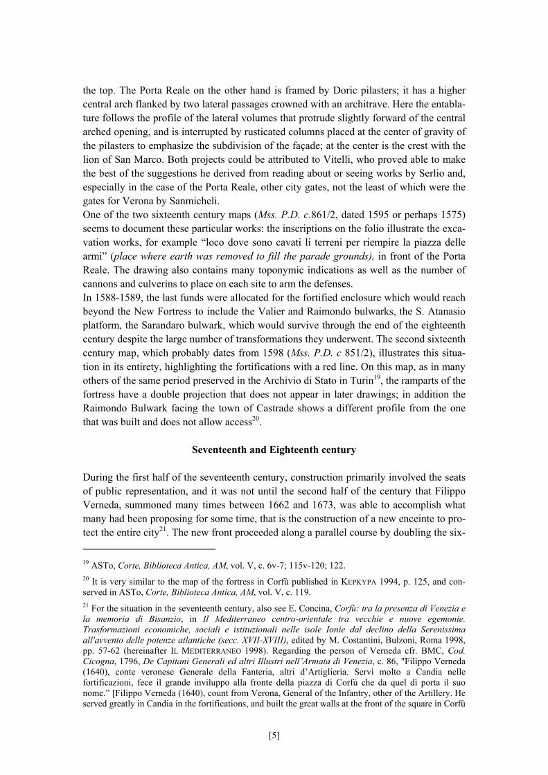
the top. The Porta Reale on the other hand is framed by Doric pilasters; it has a higher central arch flanked by two lateral passages crowned with an architrave. Here the entabla-ture follows the profile of the lateral volumes that protrude slightly forward of the central arched opening, and is interrupted by rusticated columns placed at the center of gravity of the pilasters to emphasize the subdivision of the façade; at the center is the crest with the lion of San Marco. Both projects could be attributed to Vitelli, who proved able to make the best of the suggestions he derived from reading about or seeing works by Serlio and, especially in the case of the Porta Reale, other city gates, not the least of which were the gates for Verona by Sanmicheli. One of the two sixteenth century maps (Mss. P.D. c.861/2, dated 1595 or perhaps 1575) seems to document these particular works: the inscriptions on the folio illustrate the exca-vation works, for example “loco dove sono cavati li terreni per riempire la piazza delle armi” (place where earth was removed to fill the parade grounds), in front of the Porta Reale. The drawing also contains many toponymic indications as well as the number of cannons and culverins to place on each site to arm the defenses. In 1588-1589, the last funds were allocated for the fortified enclosure which would reach beyond the New Fortress to include the Valier and Raimondo bulwarks, the S. Atanasio platform, the Sarandaro bulwark, which would survive through the end of the eighteenth century despite the large number of transformations they underwent. The second sixteenth century map, which probably dates from 1598 (Mss. P.D. c 851/2), illustrates this situa-tion in its entirety, highlighting the fortifications with a red line. On this map, as in many others of the same period preserved in the Archivio di Stato in Turin19, the ramparts of the fortress have a double projection that does not appear in later drawings; in addition the Raimondo Bulwark facing the town of Castrade shows a different profile from the one that was built and does not allow access20.
Seventeenth and Eighteenth century
During the first half of the seventeenth century, construction primarily involved the seats of public representation, and it was not until the second half of the century that Filippo Verneda, summoned many times between 1662 and 1673, was able to accomplish what many had been proposing for some time, that is the construction of a new enceinte to pro-tect the entire city21. The new front proceeded along a parallel course by doubling the six- 19 ASTo, Corte, Biblioteca Antica, AM, vol. V, c. 6v-7; 115v-120; 122. 20 It is very similar to the map of the fortress in Corfù published in ΚΕΡΚΥΡΑ 1994, p. 125, and con-served in ASTo, Corte, Biblioteca Antica, AM, vol. V, c. 119. 21 For the situation in the seventeenth century, also see E. Concina, Corfù: tra la presenza di Venezia e la memoria di Bisanzio, in Il Mediterraneo centro-orientale tra vecchie e nuove egemonie. Trasformazioni economiche, sociali e istituzionali nelle isole Ionie dal declino della Serenissima all'avvento delle potenze atlantiche (secc. XVII-XVIII), edited by M. Costantini, Bulzoni, Roma 1998, pp. 57-62 (hereinafter IL MEDITERRANEO 1998). Regarding the person of Verneda cfr. BMC, Cod. Cicogna, 1796, De Capitani Generali ed altri Illustri nell’Armata di Venezia, c. 86, "Filippo Verneda (1640), conte veronese Generale della Fanteria, altri d’Artiglieria. Servì molto a Candia nelle fortificazioni, fece il grande inviluppo alla fronte della piazza di Corfù che da quel dì porta il suo nome.” [Filippo Verneda (1640), count from Verona, General of the Infantry, other of the Artillery. He served greatly in Candia in the fortifications, and built the great walls at the front of the square in Corfù
[5]
teenth century walls, and would provide the foundation for the eighteenth century mod-ernization. Thus the new works designed and only partially completed in the seventeenth century included the following: the “reinforcement” beyond the Fossa Reale with the S. Antonio hornwork, the Corner and Grimani ravelins, the Mezzaluna, the Scarpone below the New Fortress. The map drawn by Marcello Alessandri in 1620 (Mss. Morosini Grimani 436/16) obvi-ously does not show these works but presents several suggestions that appear interesting because they would later be accepted in part by eighteenth century theoreticians. In fact Alessandri proposes to fortify Monte S. Salvatore and Monte S. Giorgio (Monte Abramo) one of the central proposals in the project by Schulemberg to renovate the fortress. One might say that in the mid-eighteenth century the defensive system of Corfu had achieved its definitive form, even though through the end of the Republic other projects would be drawn up, concerning infrastructure or logistics however rather than actual for-tifications22. The victory over the Turkish siege of Corfu in 1716 by Johann Mathias von Schulemburg (1661-1747) who had been named Field Marshal of the Venetian army only a few months earlier, is part of the myth of the Republic23. Schulemburg was still alive when he made History, since at the successful conclusion of this endeavor he was honored with a monument in the Old Fortress of Corfù, near the clock tower. Schulemburg thus became that from that day forth bear his name.] In 1680 he was summoned back from Corfù to review the forti-fications on the mainland, but it is possible that the author of the codex confuses Filippo’s work with that of Giacomo Milhau Verneda. On Verneda’s work in Corfù cfr. LEVANTE 1986, plate n. 323, pp. 208-9; PALMANOVA 1993, plate n. 33, p. 529. 22 Cfr. the 1761 documents mentioned in BMC, Mss. Donà dalle Rose 438, c. 5, Restauri fortezze di Corfù, that refer to the Senate decree dated March 7 1761, which granted approval for Lieutenant Gen-eral Greeme’s ideas for the Square in Corfù. Regarding Greeme’s work, cfr. M. Dal Borgo, La situazione delle artiglierie veneziane a Corfù attraverso le relazioni di William Gräeme e James Pattison, in IL MEDITERRANEO 1998, pp. 33-46. 23 Cfr. H. Schmidt, Il salvatore di Corfù. Johann Matthias von der Schulemburg, in "Quaderni del Centro tedesco di studi veneziani", 42, 1991, p. 3-29, in particular p. 21: hired by the Republic as Field-marshal in 1715, Schulemburg went to Corfù on February 15 1716 and began to reinforce the defenses against the now certain upcoming siege. On the figure of Schulemburg see also the synthetic note by M. Levey, A Note on Marshal Schulemberg’s Collection, in “Arte Veneta”, XII, 1958, p. 221 and, more at length, P. Rigoli, Gli ultimi anni di Schulenburg a Verona, in "Verona illustrata", 11, 1998, pp. 31-56; A. Binion, La Galleria scomparsa del Maresciallo von der Schulenburg. Un mecenate nella Venezia del Settecento, Electa, Milano 1990 (hereinafter Binion 1990); E. Concina, Κέρκυρα, µία µεσογειακή σύνθεση: νησιωτισµός, διασυνδέσεις, ανθρώπινα περιβάλλοντα, 16ος-19ος αι., edited by A. Nikiforou, proceedings of the conference held in Corfu-Κέρκυρα (May 22-25 1996), Κέρκυρα 1998, pp. 241-256 (hereinafter CONCINA 1998). For the honors bestowed upon him, also see the profile in BMC, Cod. Cicogna 1796, De Capitani Generali ed altri Illustri nell'Armata di Venezia, cc. 132-134, "anno 1715, Gio. Mattia Schulemburg del I. R. Imp. Conte Prussiano della Lusacia, Generale da sbarco, con stipendio in tempo di guerra di zechini 10.000" [the year 1715, Gio. Mattia Schulemburg of the I. R. Imp. Count Prussiano della Lusacia, Generale da sbarco, with a wartime salary of 10.000 zecchini] (c. 132). He defended the city of Corfù, conquered Vonizza and Prevesa, attacked Dolcigno. For his achievements he was rewarded with a bejeweled gold sword and cane, in addition to an annual emolument of 5.000 ducati; "dopo 31 anni di egregio servizio meritava anche nell'Arsenale che se gl'ergesse un monumento" [after 31 years of excellent service he deserved for a monument to be erected to him even in the Arsenale] (c. 133). At his death in Verona in 1748, “con magnifica pompa [venne] accompagnato il cadavere, e deposto nel bastione di Campo Marzo, e da di la nel Castello di S. Andrea del Lido a Venezia” [with magnificent pomp the corpse was accompanied, and put to rest in the Bastion of Campo Marzo, and from there in the Castello di S. Andrea del Lido in Venice] (ibidem).
[6]
the virtual father of the defenses of Corfu, given that his statue is indicated in all the eighteenth century maps (in the Nuremberg map, in Honstein’s map – n.32 of the Old Fortress: “Orlogia, ove è la stadua F.M. Schulemberg” (Clock, where stands the statue of F.M.Schulemburg) – and in Alessandro Ganassa’s map – n.17 of the Old Fortress24) where it is given the same importance as the public buildings of strategic interest. Schulemburg worked to reorganize and strengthen the fortifications of Corfu over a pe-riod of approximately twenty years, leaving many traces of his own thoughts in docu-ments, letters and drawings25. The nucleus of Schulemburg’s defense theory is the consti-tution of a series of strongholds connected by paths that are mostly underground. The new forts on Monte San Salvador and on Monte Abramo (two high points from which it was possible to launch dangerous attacks on the city) were thus connected to the city walls and transformed into a powerful defensive barrier, an impressive work not only because of the dimensions of its linear extension but also because of its remarkable depth. One cannot say that there was “a project” by Schulemburg for Corfu it was more of a flexible plan involving general strategic policy that provided a basis for the works that were built one piece at a time. During those years Shulemburg was obviously not always there to direct the works, and a long-distance control system was developed based on a continuous exchange of directives and information between the engineers working on site and the general. An essential element of these exchanges thus became the drawings, increasingly detailed and precise not only in their representation technique but especially in the way each single element of the fortress was named. Following a practice that emerged most strongly between the seventeenth and eighteenth centuries, the legends present long lists of names that allow each element of the fortifications system (increasingly complex and articulated) to be recognized quickly and with no margin for error and to intervene ex-actly where it was necessary. The legend thus became an integral part of the planning sys-tem and not simply the result of a celebratory obsession involving the protagonists and the events that took place in those sections of the fortress. For an example of the interac-tion between text and drawing, one can compare the 1735 Nuremberg engraving, printed when Schulemburg was still alive and his projects were under construction, and the letter with instructions by Schulemburg sent just a few years later to Moser de Filseck26 (Janu-ary 1738 m.v.). The 1735 Nuremberg engraving presents the essential components of the project in an articulated manner, a project also seen in many other drawings preserved at the Archivio
24 Also see the statue in the eighteenth century drawing Pianta e prospetto per l’innalzamento per il magazen del custode e dei quartieri sopra la contrafossa di Fortezza Vecchia per servir l’armamento conserved at the Archivio di Stato in Venice (hereinafter ASVe) and published in ΚΕΡΚΥΡΑ 1994, p. 135, cat. 100. 25 Cfr. principally ASVe, Archivio proprio Johann Matthias von Schulemburg, filze 24, regg. e voll. 40 (1714-1747), with documents from the sixteenth century (copies) and through 1748: it includes draw-ings, minutes, notes, studies, correspondence (in Italian, French, German) mostly relative to Corfù. For the material on Marshal Schulemburg conserved at the Biblioteca del Museo Correr also see the essay by Dott.ssa M. Ferraccioli, Catalogo dei manoscritti riguardanti Corfù nella biblioteca del Museo Correr, in the CDRom CORFÙ 2000. 26 BMC, Ms. Correr 1093, Istruzione per i lavori da intraprendersi nei Esteriori della Piazza di Corfù, Venezia, January 13 1738.
[7]
di Stato in Venice27. The structure of the legend is articulated in three sections: the new forts designed by Schulemburg, the works planned for the reinforcement of the “exteri-ors” (that is the wall system of the city), and the existing defenses both in the city and in the Old Fortress (which Shulemburg leaves almost untouched). The description of the defenses highlights the underground construction which was also quite impressive, reach-ing an overall length of 7000 toise (1,949 m) and including very large structures (for ex-ample see item n.5, an underground connection shelter that could hold up to 800 men). Much more important is the view of the land presented on this folio, a view that under-lines the impressive dimensions of the embankments of the fortresses on the mountains and of the outer defenses. This is an important image because it seems to be the only trace left of a group of views of the city of Corfu, almost all of them drawn before the 1720’s but lost after being registered in the inventory of Marshal Schulemburg’s collection28. The map made by Captain Giovanni de Honstein, extremely precise and detailed, takes care to illustrate the relationships established between the military fortifications and the overall urban system. This map is neither operative nor a planning drawing but an accu-rate synthesis of all the important factors in the defense of the city, factors that were strictly military and logistic (the fortifications system, the underground tunnels, the posi-tion of the militia lodging districts and the warehouses for food and artillery), or appar-ently less related to defense, such as the public buildings, the hospitals, the leper hospice, the porticoes along the streets, the water supplies. The Honstein map is a presentation drawing, probably intended as a gift because it features a noble family coat of arms, left blank, above the legend. It is not currently possible to identify exactly who this work was intended for: it may be noted however that in 1753 Stefano Magno finished his mandate as Provveditore and Captain of Corfu, and that in his report he writes that he largely ac-complished his duty to maintain the fortifications of the city, but that he also built the Episcopal palace and the Prefect’s palace29. The author of the drawing, the captain of the engineers Giovanni de Honstein, a relatively little known figure, under the heading “Rimarco essenzialissimo” (highly essential note) positioned under the legend, provides several notes on his own military career that en-compassed the wars in the Flanders, in Hungary and in Sicily. He was probably in the service of the Republic since the 1730’s, though his activity was documented exclusively by his drawings: in 1738 he drew a view of Padua30, in 1753 the map of Corfu dealt with here and in 1757 a representation of the port town of Govin which was only recently iden-
27 ASVe, Provveditori alle Fortezze, ex b. 79, drawing 11, Pianta d'avviso della piazza di Corfu con li progetti fatti, et da stabilirsi, proposti da S.E. Felt-Marescial Co. Di Schulemburg, Gen. in capite, 1727, the author of the drawing is Antonio Moser De Filseck. The map does not show the Forte San Rocco that is present in all the others: for the Forte San Rocco cfr. also the Pianta d'aviso per i due monti Abram, Sant Salvator, e collina Sant Rocho [in Corfu], by anonymous, XVIII cent., conserved in ASVe, Provveditori alle Fortezze, ex b. 79, drawing 14. 28 BINION 1990; CONCINA 1998. 29 Also in 1753 the Provveditore generale da Mar was Agostino Sagredo (cfr. C. A. Levi, Venezia, Corfù e il Levante. Relazione storico archivistica, Comune di Venezia, Venezia 1907 p. 100); the report by Stefano Magno dated October 29 1753, is in ASVe, Collegio, Relazioni Ambasciatori e altre cariche, Corfù (1611-1753), b. 85, two maps n.n. 30 S. Ghironi, Padova. Piante e vedute, with an essay by G. Mazzi, Panda, Padova 1987, plate n. 72.
[8]
tified and displayed in the exhibition held at the Correr Museum in 200131. The view of Padua is particularly interesting because of the combination of different types of images on the same folio: the outline of the city, an image of a clearly military nature, appears on a background of a country scene with ancient ruins in the foreground, whereas the plan, projected orthogonally, seems to focus mainly on the hydraulic system of the city and its immediate surroundings. The same graphic configuration may be seen in the folio on Go-vin but it is used in a planning context: here the most important representation is the plan of the bay, to which he added an outline of the city and a proposal for the fortification of the city by reinforcing the harbor. Though it is not possible at the moment to define his training or his work at the service of the Republic, nor to evaluate his degree of competence in the matter of fortifications, it must be recognized that Honstein possessed an uncommon graphic talent. His representa-tion of the defenses and the town of Corfu is incredibly rich in information, precise in its execution (it was undoubtedly drawn using a magnifying glass); it is also cultured and amusing, using an expedient to represent the drawings of several particularly significant areas of the defenses (a section at larger scale, plans at different levels, etcetera) drawn on sheets of paper that are rolled up and pinned to the main drawing. This graphic sophistica-tion, that distinguishes all of his drawings, is rare among the military engineers whereas it was quite common in architectural presentation drawings and treatises after the beginning of the seventeenth century, and might indicate that he was trained in that field. The Honstein map represented the state of works on the outer defenses, indicating the parts to be built and suggesting several improvements that however, as confirmed by later cartography, were generally not pursued. One of the most important integrations, the con-struction of a new ravelin between the Corner and Grimani ravelins (indicated near sec-tion C-D), is not shown in any other drawing. In several cases Honstein’s proposals coin-cide with Schulemburg’s project: this is the case of the reinforcements between the Rai-mondo and Valier Bastions, to each side of the Porta Raimonda, which later were built in part (see legend, n. 31, “Falsabragha cominziata, e non terminà”, (Fausse-braye begun, but not completed) colored in yellow, thus apparently a project by Honstein, but in fact they already appear in the 1735 engraving). Honstein remarks that the entire section of the walls around the Porta Reale was not in good condition: it was necessary to finish the Cortina Reale (the section of wall near the Gate) which had no defenses, and had become the “scovazzera” [the waste disposal site] of the city, just as work was needed on the Capitale fausse-braye which “piange abbandono da se medesima” (deplores its own abandonment). The wealth of information present in the Honstein map is unequaled by the two later maps, the one dedicated to Andrea Tron (Miss. P. D. c 842/5) and the one drawn by Ales-sandro Ganassa (Mss. P.D. c 842/4) that are however very similar in their general layout; both indicate the topography and the plan of the intra-city territory, but whereas in the Tron map, the author limits himself to a graphic reproduction of the disposition of the
31 BMC, De Lazara Pisani Zusto, cass. 7/10, Giovanni de Honstein, Pianta Geografica del porto di Govin [isola di Corfù], 1757, pen and watercolor drawing; Navigare e Descrivere. Isolari e portolani del Museo Correr di Venezia, XV-XVIII secolo, exhibition catalog (Venezia, Museo Correr, December 1 2001-April 1 2002), edited by C. Tonini and P. Lucchi, Marsilio, Venezia 2001.
[9]
plans, Ganassa – like Honstein – indicates their exact dimensions. The plan dedicated to Andrea Tron seems basically intended to provide an overall view of the system at a glance: it excludes an analytical examination of the city (the legend is minimal) whereas it provides toponymic indications as well as the names of the individual defense plazas directly on the plan. The configuration of the urban lots and the locations of the buildings of public interest may be found on all three maps, but they are definitely more detailed in Honstein’s map, which even indicates the arcaded streets and the honorific busts located along the street that runs across the Spianata and in front of the Loggia della Gran Guardia, leading to the main artery of the city. It is thus possible to derive a rather precise image of the spaces of the city and the significant elements for the reconstruction of pub-lic ceremonial32. To this information Alessandro Ganassa’s map adds the distinction be-tween Orthodox and Latin church buildings. One element that makes the Honstein map so distinctive is the mapping of all the under-ground tunnels of the fortress and Alessandro Ganassa, who also drew them with only minimal differences compared to the preceding map, might have referred to it at least in part. The zones with the largest number of underground itineraries are located under Monte S. Salvatore and the southern part of the Verneda barrier. The connection between the Verneda barrier and Monte S. Salvatore takes place through the Lunette. Honstein proposes a connection system between the S. Spiridon counterguard (the most advanced part connected to the Scarpon, see in legend, New Fortress n.24) and the Monte Abramo (see in legend, New Fortress n.27) and proposes a large number of exits especially along the Verneda line. Considering the precision of Honstein’s drawing, and observing that perhaps the informa-tion it contains might only partially correspond to the existing defense systems (for obvi-ous reasons of discretion and security) one might in any case observe that the map itself constitutes a defensive instrument for the city, a “paper” defense: the representation of an undefeatable fortification system.
Public buildings and the city
In addition to the general maps of the city of Corfu, the collections in the Museo Correr also preserve several drawings from the end of the eighteenth century that present single buildings or areas of the city. They include projects for the transformation of the Military Hospital and the port system of Spilea, and finally the plans of several city streets. The transformation project for the Military Hospital (Mss. P.D. c 859/16) located adjacent to the S. Nicolò gate, on the esplanade on the sea, involved a building that had been built for the galley crews in the first half of the sixteenth century, and which had been con-verted into a Military Hospital during the period of the sacred League. The project for the expansion of the building envisions the addition of a new wing precluding however any significant changes to the building, which was probably the result of the adaptation of earlier spaces, and without introducing a plan clearly related to the functional require-ments. The folio is the only one remaining, but was certainly part of a series of drawings that illustrated the changes to the various floors of the building. 32 NIKIFOROU 1999.
[10]
Many of the drawings regarding the urban sectors of the city illustrate the area around Spilea, an area of particular importance because of the many functions that characterized it since the mid-sixteenth century. In the mid-century it hosted a butchery, to which later additions would include a grain storage warehouse, a merchandise depot, and the quaran-tine structures for the “contumacia” (the building and the port), the Magistrate for Health. This area would be the focus of a series of projects, including the 1795 project for the for-tification of the beach or the esplanade, which also included the construction of a new city gate documented by folios Mss.P.D.c 862/133 and Mss. P.D. c 859/17 for the extension of the dock34. The area immediately adjacent to Spilea is strongly commercial in nature as is evident in maps Mss. P.D. c. 859/19 and Mss. P.D. c.859/23; the former referred without a doubt to the zone between the convents of San Francesco and the Madonna del Tenedo, near the Porta Spilea, the latter most likely refers to the nearby street near the Sarandario Bulwark between the Greek churches of Saint Basil and Saint John. It offers a very precise descrip-tion of the situation regarding the ownership and functional destination. On the ground floor, which is almost always lined with porticoes, the variety of boutiques is justified by the proximity to the wholesale commerce area of the port. The similar map Mss.P.D. c. 859/18 refers on the contrary to the city center: it shows the main road, leading from the Spianata to the Porta Reale, onto which the San Giacomo theatre35 faces.
References
Venezia, Archivio di Stato:
Archivio proprio Johann Matthias von Schulemburg, filze 24, regg. e voll. 40 (1714-1747).
Provveditori alle Fortezze, ex b. 79, drawing 11, Pianta d'avviso della piazza di Corfù con li progetti fatti, et da stabilirsi, proposti da S.E. Felt-Marescial Co. Di Schulem-burg, Gen. in capite, 1727.
Provveditori alle Fortezze, ex b. 79, drawing 14, Pianta d'aviso per i due monti Abram, Sant Salvator, e collina Sant Rocho [in Corfù], by anonymous, XVIII cent.
Collegio, Relazioni Ambasciatori e altre cariche, Corfù (1611-1753), b. 85, two maps n.n.
33 ΚΕΡΚΥΡΑ 1994, p. 167 plate n. 160, drawings a/b are published in LEVANTE 1986 p. 220 and plate n. 354. 34 Cfr. CONCINA 1998. 35 Published in LEVANTE 1986, p. 217 plate n. 350, p. 216-219; ΚΕΡΚΥΡΑ 1994, p. 61.
[11]
Venezia, Biblioteca del Museo Correr:
Mss. Correr 1214, fasc. 2740/1, copy by Andrea Marmora, Historia di Corfù descritta
da Andrea Marmora nobile corcirese. Libri otto, presso il Curti, Venetia 1672
Cod. Cicogna, 1796, De Capitani Generali ed altri Illustri nell’Armata di Venezia, c. 86 ss.
Mss. Donà dalle Rose 438, c. 5, Restauri fortezze di Corfù. De Lazara Pisani Zusto, cass. 7/10, Giovanni de Honstein, Pianta Geografica del porto
di Govin [isola di Corfù], 1757, pen and watercolor drawing, in Navigare e Descri-vere. Isolari e portolani del Museo Correr di Venezia, XV-XVIII secolo, exhibition catalog (Venezia, Museo Correr, December 1 2001-April 1 2002), ed. by Tonini C. and Lucchi P., Marsilio, Venezia 2001.
Ms. Correr 1093, Istruzione per i lavori da intraprendersi nei Esteriori della Piazza di Corfù, Venezia, January 13, 1738.
Cod. Cicogna 1796, De Capitani Generali ed altri Illustri nell'Armata di Venezia, cc. 132-134.
Mss. Donà dalle Rose 153, cc. 16-19v.
Mss. Correr 1214, fasc. 2740/4.
Torino, Archivio di Stato, Corte, Biblioteca Antica, Architettura Militare, vol. V, cc. 6v-7, 115v-116; 117-120; 122.
Bacchion E., Il dominio veneto su Corfù (1386-1797), Edizioni Altino, Venezia 1956.
Binion A., La galleria scomparsa del Maresciallo von der Schulenburg. Un mecenate nella Venezia del Settecento, Electa, Milano 1990.
Concina E. and Nikiforou-Testone A., (eds.), Corfu, History, Urban Space and Archi-tecture, XIV-XIX century, Cultural Society Korkyra, Kέρκυρα 1994.
Concina E., Città e fortezze nelle “tre isole nostre del Levante”, in Venezia e la difesa del Levante. Da Lepanto a Candia 1570-1670, Marsilio, Venezia 1986, pp. 184-194.
Concina E. and Molteni E., "La fabrica della fortezza". L'architettura militare di Venezia, Verona 2001.
Concina E., Corfù: tra la presenza di Venezia e la memoria di Bisanzio, in Il Mediterraneo centro-orientale tra vecchie e nuove egemonie. Trasformazioni economiche, sociali e istituzionali nelle isole Ionie dal declino della Serenissima all'avvento delle potenze atlantiche (secc. XVII-XVIII), edited by M. Costantini, Bulzoni, Roma 1998, pp. 57-62.
Concina E., Kέρκυρα, µία µεσογειακή σύνθεση: νησιωτισµός, διασυνδέσεις, αµθρώπινα περιβάλλοντα, 16ος-19ος αι., ed. by A. Nikiforou, proceedings of the conference held in Corfu (May 22-25 1996), Κέρκυρα 1998, pp. 241-256.
Dal Borgo M., La situazione delle artiglierie veneziane a Corfù attraverso le relazioni di William Gräeme e James Pattison, in Il Mediterraneo centro-orientale tra vecchie
[12]
e nuove egemonie. Trasformazioni economiche, sociali e istituzionali nelle isole Ionie dal declino della Serenissima all'avvento delle potenze atlantiche (secc. XVII-XVIII), ed. by M. Costantini, Bulzoni, Roma 1998, pp. 33-46.
Ferraccioli M., Catalogo dei manoscritti riguardanti Corfù nella biblioteca del Museo Correr, in Romanelli G. and Tonini C., (eds.), Corfù. Immagini e documenti dalle collezioni storiche del Museo Correr, CDRom, Comune di Venezia, Musei civici veneziani, Centro Stampa - Centro Produzione Multimediale, Venezia 2000.
Fontana V., (ed.), Struttura urbana e immagine della città nello Stato veneziano di Terraferma, CDRom, Università degli Studi di Napoli Federico II, Centro di Ricerca Iconografia della Città Europea, Università degli Studi di Venezia Ca’ Foscari, Dipartimento di Storia e Conservazione dei Beni Artistici G. Mazzariol 2003.
Ghironi S., Padova. Piante e vedute, with an essay by G. Mazzi, Panda, Padova 1987, plate n. 72.
Hale, J.R., L’organizzazione militare di Venezia nel Cinquecento, Jouvence, Roma 1990.
Levey, M., A Note on Marshal Schulemberg’s Collection, in “Arte Veneta”, XII, 1958, p. 221.
Levi C. A., Venezia, Corfù e il Levante. Relazione storico archivistica, Comune di Venezia, Venezia 1907.
Molteni E., La scienza del fortificare, in Concina E. and Molteni E., "La fabrica della fortezza". L'architettura militare di Venezia, Banca Popolare di Verona-Banco San Geminiano e San Prospero, Verona, 2001, pp. 185-292. Nikiforou, A., ∆ηµόσιες τελετές στην Κέρκυρα κατά την περίοδο της Βενετικής κυριαρχίας, 14ος-15ος αι., εκδ. Θεµέλιο, (Public ceremonies in Corfù during the Venetian domination, 14th-18th c.), 1999.
Pavan G., (ed.), Palmanova fortezza d’Europa, 1593-1993, exhibit catalog (Palmanova, 1993), Marsilio, Venezia 1993.
Rigoli P., Gli ultimi anni di Schulenburg a Verona, in "Verona illustrata", 11, 1998, pp. 31-56.
Romanelli G. and Tonini C., (eds.), Corfù. Immagini e documenti dalle collezioni storiche del Museo Correr, CDRom, Comune di Venezia, Musei civici veneziani, Centro Stampa - Centro Produzione Multimediale, Venezia 2000.
Schmidt H., Il salvatore di Corfù. Johann Matthias von der Schulemburg, in "Quaderni del Centro tedesco di studi veneziani", 42, 1991, p. 3-29.
Tonini C. and Lucchi P., (eds.), Navigare e Descrivere. Isolari e portolani del Museo Correr di Venezia, XV-XVIII secolo, Marsilio, Venezia 2001.
Venezia e la difesa del Levante. Da Lepanto a Candia 1570-1670, Marsilio, Venezia 1986.
[13]
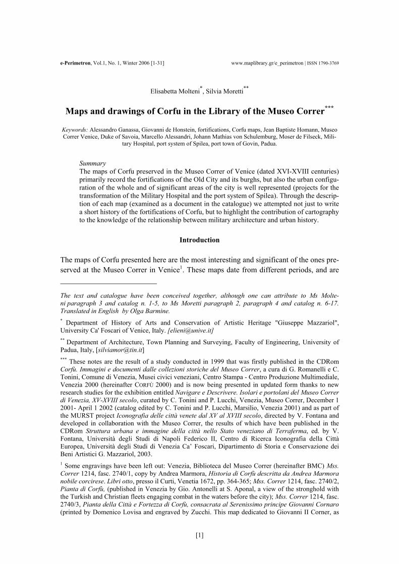
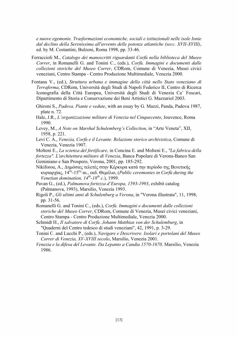
[fig. 1 P.D. c 851/2] BMC, Mss. P.D. c 851/2 (già Cicogna C Mss. F. N 43)
[Plan of Corfu: Fortezza Vecchia and city/town] Anonymous author; before 1598 (according to a nineteenth century note on the verso) or after 1577 (ac-
cording to Palmanova 1993, p. 529); pen and coloured washes on parchment, 653 x 782 mm; with scale (100 passi veneziani); orientation: wind rose, North to the lower left corner.
General plan of the fortifications of the city and the Fortress of Corfu within the context of the surround-ing area. The fifteenth century walls and The Fortezza Nuova are represented with extreme accuracy, whereas a
synthetic description is made of the orography. The city map highlights only a few churches and public buildings and some of the main streets.
Back
[14]
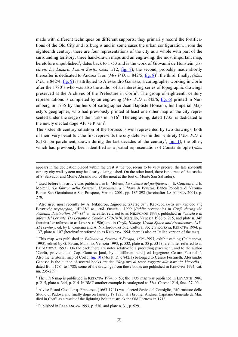
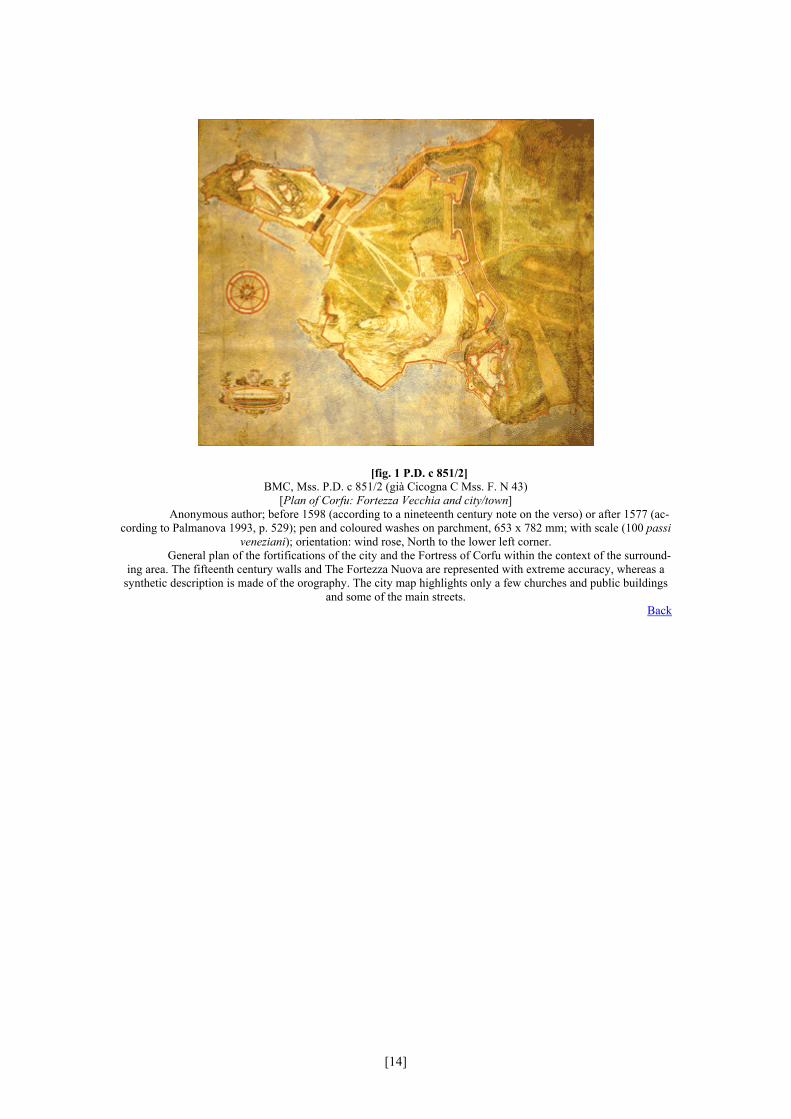
[fig. 2 P.D. c 861/2] BMC, Mss. P.D. c 861/2
[Plan of Fortezza Nuova and city walls towards the territory] Tomasso Picholo (Tommaso Picolo), last quarter of the sixteenth century; pen and coloured washes on paper
pasted on canvas, ramparts painted in red and gold, 1080 x 1130 mm; with scale (80 passi veneziani); orientation: not indicated (North to the lower left corner).
Inscribed, on the back (on canvas), damaged: All’Ecc. Sig. Gio. Andrea Vidali (?) fatto adi 8 [***]. Plan of the western fortified area, in particular of the sixteenth century curtain from the Raimondo bastion towards the Fortezza Nuova (including Porta Reale). The drawing is very accurate with careful indications of the orography
including calculations of the distance between the bastions and the surroundings hills. Back
[15]
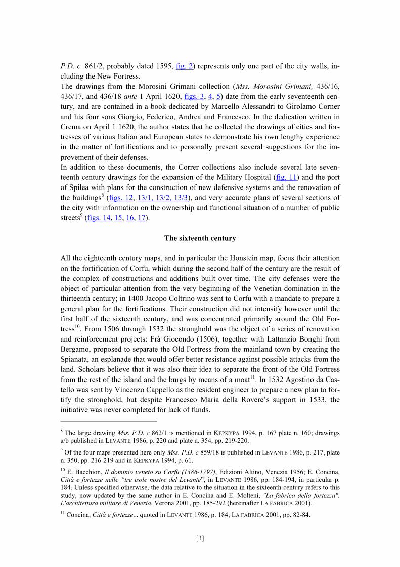
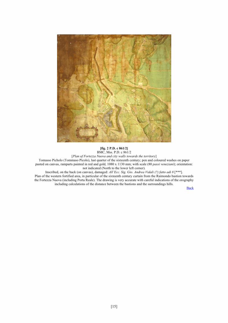
[fig. 3 Morosini Grimani, 436/16] BMC, Mss. Morosini Grimani, 436/16
[View of the fortifications of Corfu] Marcello Alessandri, before April 1, 1620; pen drawing on paper bound in a volume, 470 x 658 mm; with scale
(100 passi veneziani = 1, 738674 m o passi veneti =1,714574 m); orientation: directional arrow, North downwards. Inscribed, top right:
Corfu con le fortificazioni che si doverebbono fare nella / contrascarpa, et come doverebbono esere occupati / li duo colli per levare quelli siti a’ nemici / parere di Marcello Alessandri; A Castel Vecchio alto dal mare passa n. 45; B Castello da Mare alto
passa n. 38 Perspective plan within the territorial context including the burghs of Manducchio and Castrate; brief references to the orography. The date is related to the dedication of the volume by Marcello Alessandri to Girolamo Cornaro and
his sons Giorgio, Federico, Andrea and Francesco. Back
[16]
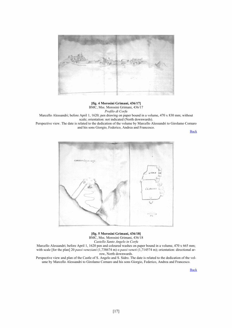
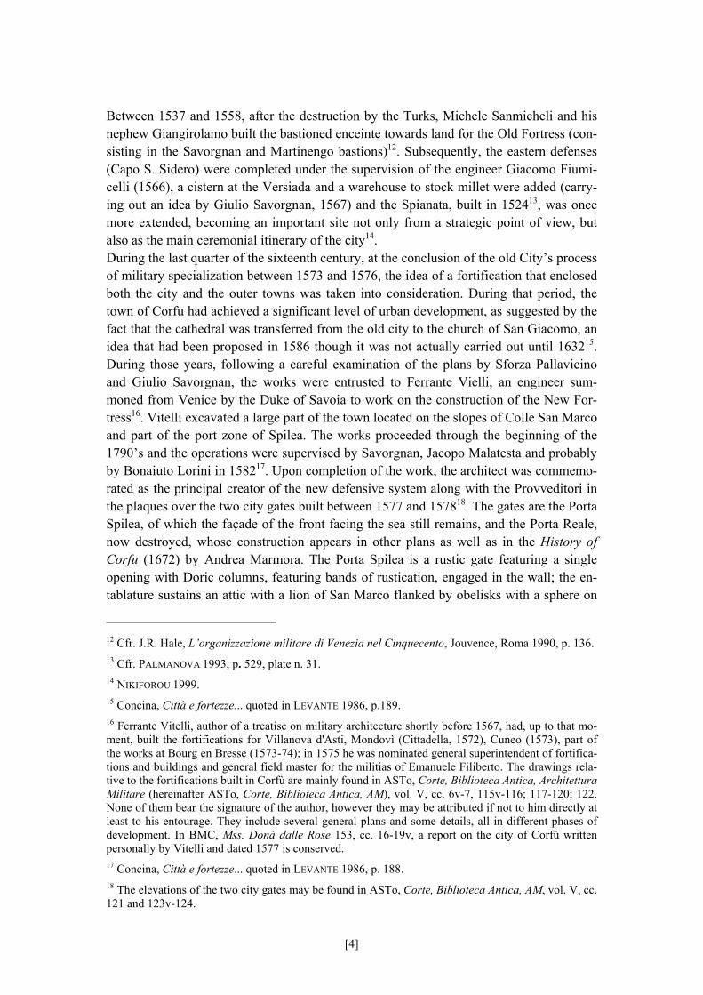
[fig. 4 Morosini Grimani, 436/17] BMC, Mss. Morosini Grimani, 436/17
Profilo di Corfu Marcello Alessandri; before April 1, 1620; pen drawing on paper bound in a volume, 470 x 830 mm; without
scale; orientation: not indicated (North downwards). Perspective view. The date is related to the dedication of the volume by Marcello Alessandri to Girolamo Cornaro
and his sons Giorgio, Federico, Andrea and Francesco. Back
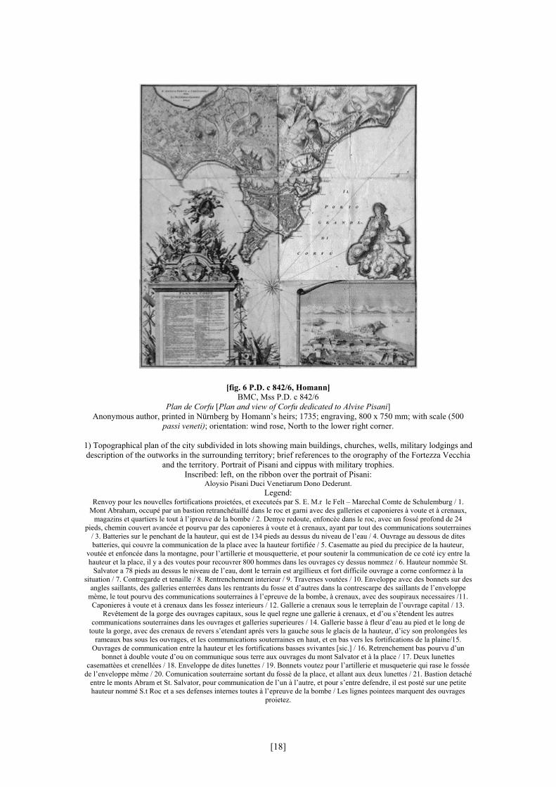
[fig. 5 Morosini Grimani, 436/18] BMC, Mss. Morosini Grimani, 436/18
Castello Santo Angelo in Corfu Marcello Alessandri; before April 1, 1620 pen and coloured washes on paper bound in a volume, 470 x 665 mm; with scale [for the plan] 20 passi veneziani (1,738674 m) o passi veneti (1,714574 m); orientation: directional ar-
row, North downwards. Perspective view and plan of the Castle of S. Angelo and S. Sidro. The date is related to the dedication of the vol-
ume by Marcello Alessandri to Girolamo Cornaro and his sons Giorgio, Federico, Andrea and Francesco.
Back
[17]
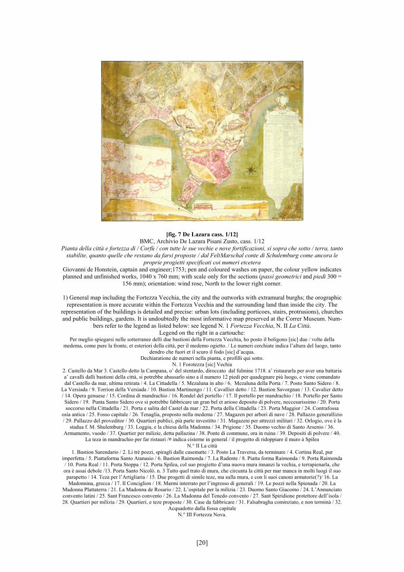
[fig. 6 P.D. c 842/6, Homann] BMC, Mss P.D. c 842/6
Plan de Corfu [Plan and view of Corfu dedicated to Alvise Pisani] Anonymous author, printed in Nürnberg by Homann’s heirs; 1735; engraving, 800 x 750 mm; with scale (500
passi veneti); orientation: wind rose, North to the lower right corner.
1) Topographical plan of the city subdivided in lots showing main buildings, churches, wells, military lodgings and description of the outworks in the surrounding territory; brief references to the orography of the Fortezza Vecchia
and the territory. Portrait of Pisani and cippus with military trophies. Inscribed: left, on the ribbon over the portrait of Pisani:
Aloysio Pisani Duci Venetiarum Dono Dederunt. Legend:
Renvoy pour les nouvelles fortifications proietées, et executeés par S. E. M.r le Felt – Marechal Comte de Schulemburg / 1. Mont Abraham, occupé par un bastion retranchétaillé dans le roc et garni avec des galleries et caponieres à voute et à crenaux,
magazins et quartiers le tout à l’ipreuve de la bombe / 2. Demye redoute, enfoncèe dans le roc, avec un fossé profond de 24 pieds, chemin couvert avancée et pourvu par des caponieres à voute et à crenaux, ayant par tout des communications souterraines
/ 3. Batteries sur le penchant de la hauteur, qui est de 134 pieds au dessus du niveau de l’eau / 4. Ouvrage au dessous de dites batteries, qui couvre la communication de la place avec la hauteur fortifiée / 5. Casematte au pied du precipice de la hauteur,
voutée et enfoncée dans la montagne, pour l’artillerie et mousquetterie, et pour soutenir la communication de ce coté icy entre la hauteur et la place, il y a des voutes pour recouvrer 800 hommes dans les ouvrages cy dessus nommez / 6. Hauteur nommèe St.
Salvator a 78 pieds au dessus le niveau de l’eau, dont le terrain est argillieux et fort difficile ouvrage a corne conformez à la situation / 7. Contregarde et tenaille / 8. Rentrenchement interieur / 9. Traverses voutées / 10. Enveloppe avec des bonnets sur des
angles saillants, des galleries enterrées dans les rentrants du fosse et d’autres dans la contrescarpe des saillants de l’enveloppe mème, le tout pourvu des communications souterraines à l’epreuve de la bombe, à crenaux, avec des soupiraux necessaires /11. Caponieres à voute et à crenaux dans les fossez interieurs / 12. Gallerie a crenaux sous le terreplain de l’ouvrage capital / 13.
Revêtement de la gorge des ouvrages capitaux, sous le quel regne une gallerie à crenaux, et d’ou s’êtendent les autres communications souterraines dans les ouvrages et galleries superieures / 14. Gallerie basse à fleur d’eau au pied et le long de
toute la gorge, avec des crenaux de revers s’etendant aprés vers la gauche sous le glacis de la hauteur, d’icy son prolongées les rameaux bas sous les ouvrages, et les communications souterraines en haut, et en bas vers les fortifications de la plaine/15.
Ouvrages de communication entre la hauteur et les fortifications basses svivantes [sic.] / 16. Retrenchement bas pourvu d’un bonnet à double voute d’ou on communique sous terre aux ouvrages du mont Salvator et à la place / 17. Deux lunettes
casemattèes et crenellées / 18. Enveloppe de dites lunettes / 19. Bonnets voutez pour l’artillerie et musqueterie qui rase le fossée de l’enveloppe même / 20. Comunication souterraine sortant du fossè de la place, et allant aux deux lunettes / 21. Bastion detaché
entre le monts Abram et St. Salvator, pour communication de l’un à l’autre, et pour s’entre defendre, il est posté sur une petite hauteur nommé S.t Roc et a ses defenses internes toutes à l’epreuve de la bombe / Les lignes pointees marquent des ouvrages
proietez.
[18]

Renvoy pour les ouvrages qu’on a fait pour rectifier le front exterieur de la place / a. Contregarde St. Spiridion avec une gallerie et caponieres dans son fossé et chemin couvert, et avec une casematte de revers pour raser le rivage de la mer / b. Tenaillon excavé dans le roc, qui domine par dessus la dite contregarde / c. Enceinte qui enferme le rivage de la mer, avec une gallerie crenellée au dessous, et des batteries au dessus / d. Grande tenaille qu’on appelle Scarpon et qui a êté reduit en un ouvrage à
corne / e. Fossé entre le Scarpon et la Fortresse Neuve, qu’on a approfondi dans le roc / f. Place d’armes au devant du Scarpon, avec un logement de masonnerie crenellé, et contrescarpe pourvue d’une galllerie / g. Deux caponieres casemattées pour la
defense interne du fossé du Scarpon / h. Contrescarpe nouvellement erigée d’un bout à l’autre du front haute de seize pieds / i. Murailles crenellées, pour couvrir les poternes de communication, et defendre le fossé / j. Caponieres voutées, et crenellées pour
l’artillerie et mousqueterie / k. Lunette avec deux places d’armes sur la contrescarpe / l. Place d’armes avec son logement de masonnerie, et chemin couvert à droite et à gauche / m. Couvre-face construite dans l’eau / n. Basse tenaille avec des caponieres
voutées au dessous les profils de ses extremitez / o. Enceinte, qui ferme l’extremité de la mer / p. Retrenchement dans l’ouvrage à corne St. Antoine / q. Logements masonnez et crenellez dans le centre des revelins / r. Fausse braye [sic.] Au pied du corps de la place / s. Casernes et hopitaux / nb il y a en matiere de galleries voutes et casemattes en tout 7000 toises d’etendue en cette place. Icy suivent les fortifications vieilles de la place / aa. Forteresse Neuve située sur une hauteur de rocher, et qui donne par dessus le mont Abram de 30 pieds environs / bb. Fortifications basses de la même forteresse du coté de la mer / cc. Bastion Sarandaris / dd. Platte fome St. Athanase / ee. Bastion Raymonde / ff. Demi bastion Raymonde / depuis la Forteresse Neuve jusq’icy est le front
du corps de la place superieur de six pieds au mont Salvator / gg. Bastion Valier / hh. Ouvrage à corne St. Antoine avec son ravelin / ii. Ravelin Corner / jj. Ravelin Grimani / kk. Demye lune Grimani / ll. Porte Royale / mm Porte Raymonde / nn. Porte
Spilée / oo. Porte St. Nicolas / pp. Vieille Forteresse qui est la cittadelle de Corfù, dont le poligon contre la ville a double casematte avec une contrescarpe haute de 40 pieds et une lunette d’eau / qq. Fortification projettée sur la contrescarpe de la dicte forteresse / rr. Front ancien de la dicte forteresse qui sert à present des rentrenchement / ss. Chateau nommée della Campana, ou soit de la cloche, situé sur un rocher haut de 210 pieds et ruiné par un incendie de la poudre, causée par une foudre l’an 1718/ tt. Chateau de mer situé sur un rocher plus bas que le premier / uu. Cittadelle superieure postée entre ces deux chateau / vv. Deux
demyes lunes plantées sur la ponte du rocher / ww. Port pour les galleres, galleasses et galliottes / җ Statue du Marechal de Schulemburg que le Senat luy fit eriger au reconnoissance de la glorieuse defense de cette place contre les Turcs, l’an 1716 / Ø Il Domo / L’Annunziata / ♂ St. Francesco / д La Madonna del Tenedo / ♀St. Spiridione / + Palazzo Generalizio / Magazeni
polvere / # Gran Guardia / Sinagoge [sic.] dei hebrei
2) Lower right, on a small scroll rolled up and pinned to the main drawing: perspective view of the land ramparts of the fortress including the city, the Fortezza Vecchia and the sea toward the albanian mainland.
Back
[19]
[fig. 7 De Lazara cass. 1/12] BMC, Archivio De Lazara Pisani Zusto, cass. 1/12
Pianta della città e fortezza di / Corfù / con tutte le sue vechie e nove fortificazioni, si sopra che sotto / terra, tanto stabilite, quanto quelle che restano da farsi proposte / dal FeltMarschal conte di Schulemburg come ancora le
proprie progietti specificati coi numeri etcetera Giovanni de Honstein, captain and engineer;1753; pen and coloured washes on paper, the colour yellow indicates planned and unfinished works, 1040 x 760 mm; with scale only for the sections (passi geometrici and piedi 300 =
156 mm); orientation: wind rose, North to the lower right corner.
1) General map including the Fortezza Vecchia, the city and the outworks with extramural burghs; the orographic representation is more accurate within the Fortezza Vecchia and the surrounding land than inside the city. The
representation of the buildings is detailed and precise: urban lots (including porticoes, stairs, protrusions), churches and public buildings, gardens. It is undoubtedly the most informative map preserved at the Correr Museum. Num-
bers refer to the legend as listed below: see legend N. 1 Fortezza Vecchia, N. II La Città. Legend on the right in a cartouche:
Per meglio spiegarsi nelle sotterranee delli due bastioni della Fortezza Vecchia, ho posto il boligono [sic] due / volte della medema, come pure la fronte, et esteriori della città, per il medemo ogietto. / Le numeri cerchiate indica l’altura del luogo, tanto
dendro che fuori et il scuro il fodo [sic] d’acqua. Dechiaratione de numeri nella pianta, e profilli qui sotto.
N. 1 Forotezza [sic] Vechia 2. Castello da Mar 3. Castello detto la Campana, o’ del stentardo, diroccato dal fulmine 1718. a’ ristaurarla per aver una battaria a’ cavalli dalli bastioni della città, si potrebbe abassarlo sino a il numero 12 piedi per quadegnare più luogo, e viene comandato dal Castello da mar, ultima retirata / 4. La Cittadella / 5. Mezaluna in alto / 6. Mezaluna della Porta / 7. Posto Santo Sidero / 8.
La Versiada / 9. Torrion della Versiada / 10. Bastion Martinengo / 11. Cavallier detto / 12. Bastion Savorgnan / 13. Cavalier detto / 14. Opera genuese / 15. Cordina di mandrachio / 16. Rondel del portello / 17. Il portello per mandrachio / 18. Portello per Santo Sidero / 19. Punta Santo Sidero ove si potrebbe fabbricare un gran bel et arioso deposito di polvere, neccesarissimo / 20. Porta soccorso nella Cittadella / 21. Porta e salita del Castel da mar / 22. Porta della Cittadella / 23. Porta Maggior / 24. Contrafossa
osia antica / 25. Fosso capitale / 26. Tenaglia, proposto nella medema / 27. Magazen per arbori di nave / 28. Pallazzo generallizio / 29. Pallazzo del proveditor / 30. Quartieri publici, più parte investitto / 31. Magazeni per attrezzi militari / 32. Orlogio, ove è la
stadua f. M. Shulemburg / 33. Loggia, e la chiesa della Madonna / 34. Prigione / 35. Duomo vechio di Santo Arsenio / 36. Armamento, vuodo / 37. Quartier per milizie, detta pallazina / 38. Ponte di commune, ora in ruina / 39. Depositi di polvere / 40.
La teza in mandrachio per far ristauri /¤ indica cisterne in general / il progetto di ridoppiare il muro à Spilea N.° II La città
1. Bastion Sarendario / 2. Li trè pozzi, spiragli dalle casematte / 3. Posto La Traversa, da terminare / 4. Cortina Real, pur imperfetta / 5. Piattaforma Santo Atanasio / 6. Bastion Raimonda / 7. La Radente / 8. Piatta forma Raimonda / 9. Porta Raimonda / 10. Porta Real / 11. Porta Stoppa / 12. Porta Spilea, col suo progietto d’una nuova mura innanzi la vechia, e terrapienarla, che ora è assai debole /13. Porta Santo Nicolò. n. 3 Tutto quel trato di mura, che circunta la città per mar manca in molti luogi il suo
parapetto / 14. Teza per l’Artigliaria / 15. Due progetti di simile teze, ma sulla mura, e con li suoi canoni armatorie(?)/ 16. La Madonnina, grecca / 17. Il Conciglion / 18. Marmi interrato per l’ingresso di generali / 19. Le pozzi nella Spienada / 20. La
Madonna Plattaterra / 21. La Madonna de Rosario / 22. L’ospitale per la milizia / 23. Duomo Santo Giacomo / 24. L’Annunciato convento latini / 25. Sant Francesco convento / 26. La Madonna del Tenedo convento / 27. Sant Spiridione protettore dell’isola / 28. Quartieri per milizia / 29. Quartieri, e teze proposte / 30. Case da fabbricare / 31. Falsabragha cominziato, e non terminà / 32.
Acquadotto dalla fossa capitale N.° III Fortezza Nova.
[20]
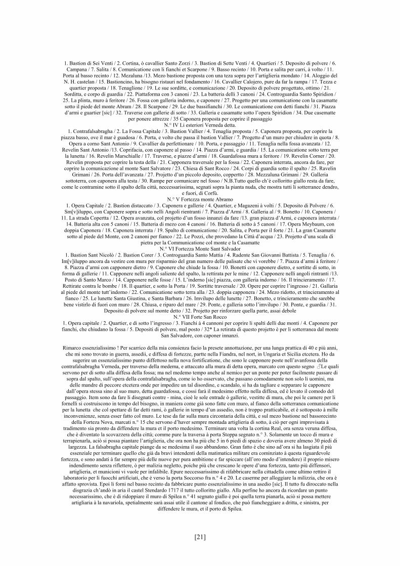
1. Bastion di Sei Venti / 2. Cortina, ò cavallier Santo Zorzi / 3. Bastion di Sette Venti / 4. Quartieri / 5. Deposito di polvere / 6. Campana / 7. Salita / 8. Comunicatione con li fianchi et Scarpone / 9. Basso recinto / 10. Porta e salita per carri, à volto / 11.
Porta al basso recinto / 12. Mezaluna /13. Mezo bastione proposta con una teza sopra per l’artiglieria mondato / 14. Aloggio del N. H. castelan / 15. Bastioncino, ha bisogno ristauri nel fondamento / 16. Cavallier Calojero, pure da far la rampa / 17. Tezza e
quartier proposta / 18. Tenaglione / 19. Le sue sorditte, e comunicazione / 20. Deposito di polvere progettato, ottimo / 21. Sorditta, e corpo di guardia / 22. Piattaforma con 3 canoni / 23. La batteria delli 3 canoni / 24. Controguardia Santo Spiridion / 25. La plinta, muro à feritore / 26. Fossa con galleria indorno, e caponere / 27. Progetto per una comunicatione con la casamatte sotto il piede del monte Abram / 28. Il Scarpone / 29. Le due bassifianchi / 30. Le comunicatione con detti fianchi / 31. Piazza d’armi e guartier [sic] / 32. Traverse con gallerie di sotto / 33. Galleria e casamatte sotto l’opera Spiridion / 34. Due casematte
per ponere attrezze / 35 Caponera proposta per coprire il passaggio N.° IV Li esteriori Verneda detta.
1. Contrafalsabragha / 2. La Fossa Capitale / 3. Bastion Vallier / 4. Tenaglia proposta / 5. Caponera proposta, per coprire la piazza basso, ove il mar è guadosa / 6. Porta, e volto che passa il bastion Vallier / 7. Progetto d’un muro per chiudere in quota / 8.
Opera a corno Sant Antonio / 9. Cavallier da perfettionare / 10. Porta, e passaggio / 11. Tenaglia nella fossa avanzata / 12. Revelin Sant Antonio /13. Coprifacia, con caponere al passo / 14. Piazza d’armi, e guardia / 15. La comunicatione sotto terra per
la lunetta / 16. Revelin Marschialle / 17. Traverse, e piazze d’armi / 18. Guardafossa mura a feritore / 19. Revelin Corner / 20. Revelin proposta per coprire la testa della / 21. Capponera traversale per la fossa / 22. Caponera interrata, ancora da fare, per
coprire la comunicazione al monte Sant Salvatore / 23. Chiesa di Sant Rocco / 24. Corpi di guardia sotto il spalto / 25. Ravelin Grimani / 26. Porta dell’avanzata / 27. Projetto d’un piccolo deposito, coppertto / 28. Mezzaluna Grimani / 29. Galleria
sottoterra, con caponera alla testa / 30. Rampe per comunicare nel fosso / N.B.Tutto quello ch’è colloritto giallo resta da fare, come le contramine sotto il spalto della città, neccessarissima, segnati sopra la pianta nuda, che mostra tutti li sotterranee dendro,
e fuori, di Corfù. N.° V Fortezza monte Abramo
1. Opera Capitale / 2. Bastion distaccato / 3. Caponera e gallerie / 4. Quartier, e Magazeni à volti / 5. Deposito di Polvere / 6. Sm[v]iluppo, con Caponere sopra e sotto nelli Angoli rientranti / 7. Piazza d’Armi / 8. Galleria al / 9. Bonetto / 10. Caponera /
11. La strada Copertta / 12. Opera avanzata, col projetto d’un fosso innanzi da fare /13. gran piazza d’Armi, e caponera interrata / 14. Batteria alta con 5 canoni / 15. Batteria di mezo con 4 canoni / 16. Batteria di sotto à 5 canoni / 17. Opera Meybaum, con
doppia Caponera / 18. Caponera interrata / 19. Spalto di comunicatione / 20. Salita, e Porta per il forte / 21. La gran Casamatte sotto al piede del Monte, con 2 canoni per fianco / 22. Le Pozzi, che provedano la Città d’acqua / 23. Projetto d’una scala di
pietra per la Communicatione col monte e la Casamatte N.° VI Fortezza Monte Sant Salvador
1. Bastion Sant Nicolò / 2. Bastion Corer / 3. Controguardia Santo Mattia / 4. Radente San Giovanni Battista / 5. Tenaglia / 6. Im[v]iluppo ancora da vestire con mura per risparmio del gran numero delle palisate che vi vorebbe / 7. Piazza d’armi à feritore /
8. Piazza d’armi con capponere dietro / 9. Caponere che chiude la fossa / 10. Bonetti con caponere dietro, e sortitte di sotto, in forma di gallerie / 11. Capponere nelli angoli saliente del spalto, la rettirata per le mine / 12. Capponere nelli angoli rintranti /13.
Posto di Santo Marco / 14. Capponere nelle fosse / 15. L’inderno [sic] piazza, con galleria indorno / 16. Il trincieramento / 17. Rettirate contra le bombe / 18. Il quartier, e sotto la Porta / 19. Sortitte traversale / 20. Opere per coprire l’ingresso / 21. Gallaria
al piede del monte tutt’indorno / 22. Comunicatione sotto terra alla / 23. doppia capponera / 24. Mezo ridotto, et trincieramento al fianco / 25. Le lunette Santa Giustina, e Santa Barbara / 26. Imvilupo delle lunette / 27. Bonetto, e trincieramento che sarebbe
bene vistirlo di fuori con muro / 28. Chiusa, e riparo del mare / 29. Ponte, e galleria sotto l’imvilupo / 30. Ponte, e guardia / 31. Deposito di polvere sul monte detto / 32. Projetto per rinforzare quella parte, assai debole
N.° VII Forte San Rocco 1. Opera capitale / 2. Quartier, e di sotto l’ingresso / 3. Fianchi à 4 cannoni per coprire li spalti delli due monti / 4. Caponere per fianchi, che chiudano la fossa / 5. Depositi di polvere, mal posto / 32* La retirata di questo projetto è per li sotterranea dal monte
San Salvadore, con caponer innanzi.
Rimarco essenzialissimo ! Per scarrico della mia consienza facio la presete annottazione, per una lunga prattica di 40 e più anni, che mi sono trovato in guerra, assedii, e diffesa di fortezze, partte nella Fiandra, nel nort, in Ungaria et Sicilia etcetera. Ho da
sugerire un essenzialissimo punto diffettoso nella nova fortificatione, che sono le capponere poste nell’avanfossa della contrafalsabragha Verneda, per traverso della medema, e attaccato alla mura di detta opera, marcato con questo segno ♂Le quali servono per di sotto alla diffesa della fossa; ma nel medemo tempo anche al nemico per un ponte per poter facilmente passare di
sopra dal spalto, sull’opera della contrafalsabragha, come io ho osservato, che passano comodamente non solo li uomini, ma delle mandre di peccore etcetera onde per impedire un tal disordine, e scandalo, si ha da tagliare e sepparare le capponere
dall’opera stessa sino al suo muro, detta guardafossa, e cossi farà il medesimo effetto nella diffesa, ed è levato il comodo del passaggio. Item sono da fare li disegnati contre - mina, cioè le sole entrade ò gallerie, vestitte di mura, che poi le camere per li
fornelli si costruiscono in tempo del bisogno, in maniera come già sono fatte con muro, al fianco della sotterranea comunicatione per la lunetta che col spettare di far detti rami, ò gallerie in tempo d’un assedio, non è troppo pratticabile, et è sottoposto à mille inconvenienze, senza esser fatto col muro. Le tese da far sulla mura circontaria della città, e sul mezo bastione nel bassorecinto
della Forteza Nova, marcati n.° 15 che servono d’haver sempre montada artiglieria di sotto, à ciò per ogni improvisata à tradimento sia pronto da diffendere la mura et il porto medesimo. Terminare una volta la cortina Real, ora senza veruna diffesa,
che è diventato la scovazzera della città; comme pure la traversa à porta Stoppa segnato n.° 3. Solamente un tocco di mura e terrapienarla, aciò si possa piantare l’artiglieria, che ora non ha più che 5 in 6 piedi di spazio e doveria avere almeno 30 piedi di
largezza. La falsabragha capitale piange da se medesima il suo abbandono. Gran fatto è che sino ad’ora si ha lasgiata il più essenziale per terminare quello che già da bravi intendenti della matimatica militare era cominziato à questa riguardevole
fortezza, e sono andati à far sempre più delle nuove per pura ambitione e far spiccare (all’oro modo d’intendere) il proprio misero indendimento senza riflettere, ò per malizia negletto, poiche più che crescano le opere d’una fortezza, tanto più diffensori, artiglieria, et municioni vi vuole per infalibile. Epure neccessarissimo di rifabbricare nella cittadella come ultimo rettiro il
laboratorio per li fuocchi artificiati, che è verso la porta Soccorso fra n.° 4 e 20. Le caserme per alloggiare la milizzia, che ora è affatto sprovista. Epoi li forni nel basso recinto da fabbricare punto essenzialissimo in una asedio [sic]. Il tutto fu diroccato nella
disgrazia ch’andò in aria il castel Stendardo 1717 il tutto colloritto giallo. Alla perfine ho ancora da ricordare un punto necessarissimo, che è di ridoppiare il muro di Spilea n.° 41 segnato giallo è poi quella terra pianarla, aciò si possa mettere artigliaria à la navariola, spetialmente sarà assai utile il cantone al fondico, che può fiancheggiare a dritta, e sinistra, per
diffendere le mura, et il porto di Spilea.
[21]
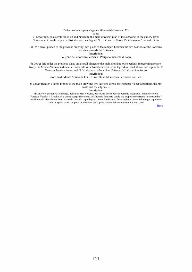
Delineato da me capitano ingegner Giovanni de Honstein 1753 sopra
2) Lower left, on a scroll rolled up and pinned to the main drawing: plan of the outworks at the gallery level. Numbers refer to the legend as listed above: see legend N. III Fortezza Nuova IV Li Esteriori Verneda detta.
3) On a scroll pinned to the previous drawing: two plans of the rampart between the two bastions of the Fortezza
Vecchia towards the Spianata. Inscription:
Poligono della fortezza Vecchia / Poligono medemo di sopra
4) Lower left under the previous plans on a scroll pinned to the main drawing: two sections, representing respec-tively the Monte Abramo and San Salvador hill forts. Numbers refer to the legend as listed above: see legend N. V
Fortezza Monte Abramo and N. VI Fortezza Monte Sant Salvador VII Forte San Rocco. Inscription:
Proffillo di Monte Abrmo da E a F / Proffillo di Monte San Salvadore da G a H
5) Lower right on a scroll pinned to the main drawing: two sections across the Fortezza Vecchia bastions, the Spi-anata and the city walls.
Inscription: Proffillo del bastione Martinengo, della Fortezza Vecchia, per vedere le sue belle sotterranie casematte / avan fossa della
Fortezza Vecchia / Il spalto, osia contra scarpa sino dietro la Madonna Pattiterra con le sue proposte sotterranie in contromine / proffillo dalla piattaforma Santo Atanasio (recindo capitale) con la sua falsabragha; fossa capitale, contra falsabraga, capponere,
sino sul spalto ove si propone un ravelino, per coprire la testa della capponera. Lettera c. e d Back
[22]
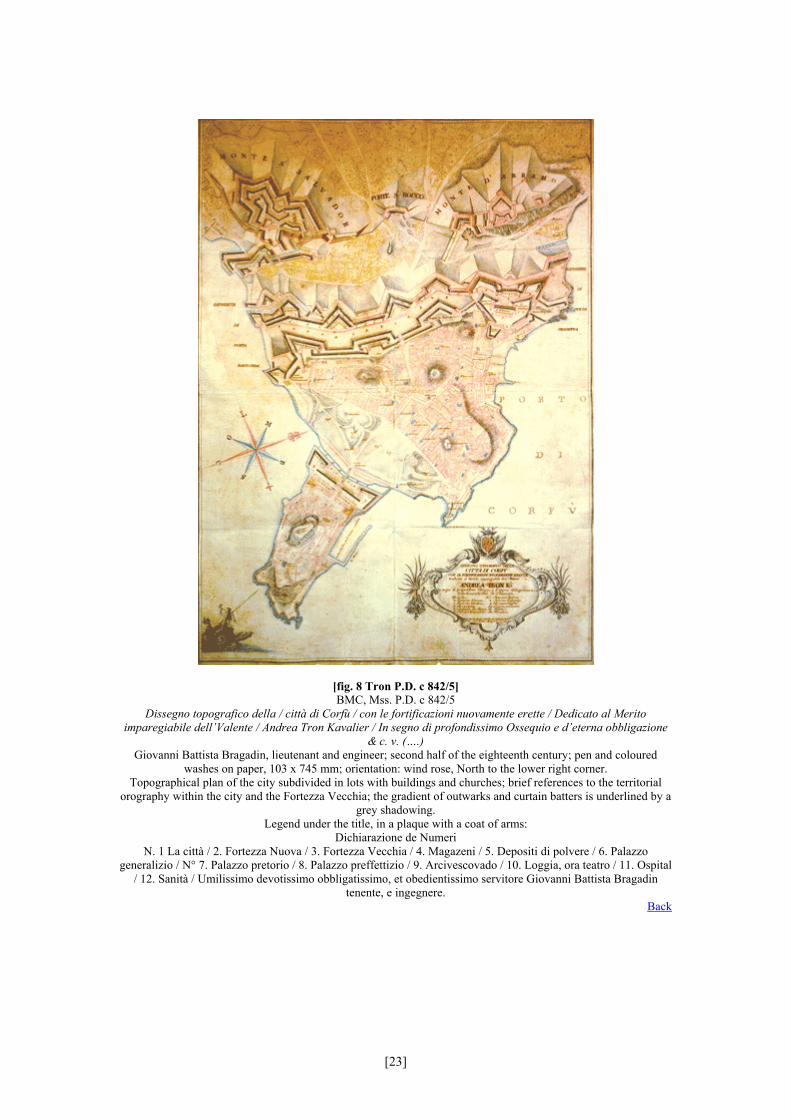
[fig. 8 Tron P.D. c 842/5] BMC, Mss. P.D. c 842/5
Dissegno topografico della / città di Corfù / con le fortificazioni nuovamente erette / Dedicato al Merito imparegiabile dell’Valente / Andrea Tron Kavalier / In segno di profondissimo Ossequio e d’eterna obbligazione
& c. v. (….) Giovanni Battista Bragadin, lieutenant and engineer; second half of the eighteenth century; pen and coloured
washes on paper, 103 x 745 mm; orientation: wind rose, North to the lower right corner. Topographical plan of the city subdivided in lots with buildings and churches; brief references to the territorial
orography within the city and the Fortezza Vecchia; the gradient of outwarks and curtain batters is underlined by a grey shadowing.
Legend under the title, in a plaque with a coat of arms: Dichiarazione de Numeri
N. 1 La città / 2. Fortezza Nuova / 3. Fortezza Vecchia / 4. Magazeni / 5. Depositi di polvere / 6. Palazzo generalizio / N° 7. Palazzo pretorio / 8. Palazzo preffettizio / 9. Arcivescovado / 10. Loggia, ora teatro / 11. Ospital
/ 12. Sanità / Umilissimo devotissimo obbligatissimo, et obedientissimo servitore Giovanni Battista Bragadin tenente, e ingegnere.
Back
[23]
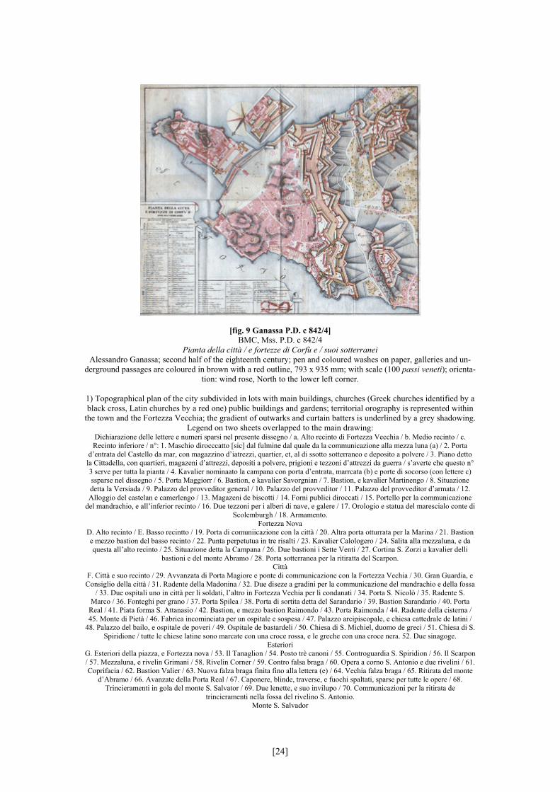
[fig. 9 Ganassa P.D. c 842/4] BMC, Mss. P.D. c 842/4
Pianta della città / e fortezze di Corfù e / suoi sotterranei Alessandro Ganassa; second half of the eighteenth century; pen and coloured washes on paper, galleries and un-
derground passages are coloured in brown with a red outline, 793 x 935 mm; with scale (100 passi veneti); orienta-tion: wind rose, North to the lower left corner.
1) Topographical plan of the city subdivided in lots with main buildings, churches (Greek churches identified by a black cross, Latin churches by a red one) public buildings and gardens; territorial orography is represented within
the town and the Fortezza Vecchia; the gradient of outwarks and curtain batters is underlined by a grey shadowing. Legend on two sheets overlapped to the main drawing:
Dichiarazione delle lettere e numeri sparsi nel presente dissegno / a. Alto recinto di Fortezza Vecchia / b. Medio recinto / c. Recinto inferiore / n°: 1. Maschio dirocccatto [sic] dal fulmine dal quale da la communicazione alla mezza luna (a) / 2. Porta
d’entrata del Castello da mar, con magazzino d’iatrezzi, quartier, et, al di ssotto sotterraneo e deposito a polvere / 3. Piano detto la Cittadella, con quartieri, magazeni d’attrezzi, depositi a polvere, prigioni e tezzoni d’attrezzi da guerra / s’averte che questo n° 3 serve per tutta la pianta / 4. Kavalier nominaato la campana con porta d’entrata, marrcata (b) e porte di socorso (con lettere c) ssparse nel dissegno / 5. Porta Maggiorr / 6. Bastion, e kavalier Savorgnian / 7. Bastion, e kavalier Martinengo / 8. Situazione detta la Versiada / 9. Palazzo del provveditor general / 10. Palazzo del provveditor / 11. Palazzo del provveditor d’armata / 12. Alloggio del castelan e camerlengo / 13. Magazeni de biscotti / 14. Forni publici diroccati / 15. Portello per la communicazione
del mandrachio, e all’inferior recinto / 16. Due tezzoni per i alberi di nave, e galere / 17. Orologio e statua del marescialo conte di Scolemburgh / 18. Armamento.
Fortezza Nova D. Alto recinto / E. Basso recintto / 19. Porta di comuniicazione con la città / 20. Altra porta otturrata per la Marina / 21. Bastion e mezzo bastion del basso recinto / 22. Punta perpetutua in tre risalti / 23. Kavalier Calologero / 24. Salita alla mezzaluna, e da questa all’alto recinto / 25. Situazione detta la Campana / 26. Due bastioni i Sette Venti / 27. Cortina S. Zorzi a kavalier delli
bastioni e del monte Abramo / 28. Porta sotterranea per la ritiratta del Scarpon. Città
F. Città e suo recinto / 29. Avvanzata di Porta Magiore e ponte di communicazione con la Fortezza Vechia / 30. Gran Guardia, e Consiglio della città / 31. Radente della Madonina / 32. Due diseze a gradini per la communicazione del mandrachio e della fossa
/ 33. Due ospitali uno in città per li soldati, l’altro in Fortezza Vechia per li condanati / 34. Porta S. Nicolò / 35. Radente S. Marco / 36. Fonteghi per grano / 37. Porta Spilea / 38. Porta di sortita detta del Sarandario / 39. Bastion Sarandario / 40. Porta
Real / 41. Piata forma S. Attanasio / 42. Bastion, e mezzo bastion Raimondo / 43. Porta Raimonda / 44. Radente della cisterna / 45. Monte di Pietà / 46. Fabrica incominciata per un ospitale e sospesa / 47. Palazzo arcipiscopale, e chiesa cattedrale de latini /
48. Palazzo del bailo, e ospitale de poveri / 49. Ospitale de bastardeli / 50. Chiesa di S. Michiel, duomo de greci / 51. Chiesa di S. Spiridione / tutte le chiese latine sono marcate con una croce rossa, e le greche con una croce nera. 52. Due sinagoge.
Esteriori G. Esteriori della piazza, e Fortezza nova / 53. Il Tanaglion / 54. Posto trè canoni / 55. Controguardia S. Spiridion / 56. Il Scarpon / 57. Mezzaluna, e rivelin Grimani / 58. Rivelin Corner / 59. Contro falsa braga / 60. Opera a corno S. Antonio e due rivelini / 61. Coprifacia / 62. Bastion Valier / 63. Nuova falza braga finita fino alla lettera (e) / 64. Vechia falza braga / 65. Ritirata del monte
d’Abramo / 66. Avanzate della Porta Real / 67. Caponere, blinde, traverse, e fuochi spaltati, sparse per tutte le opere / 68. Trincieramenti in gola del monte S. Salvator / 69. Due lenette, e suo invilupo / 70. Communicazioni per la ritirata de
trincieramenti nella fossa del rivelino S. Antonio. Monte S. Salvador
[24]

H. Monte S. Salvador / 71. Salita e porta di comunicazione all’opera capitale / 72. Trincieramento in golla dell’opera capitale / 73. Bastion Corner / 74. Bastion S. Nicolò / 75. Copribombe e traversoni / 76. Controguardia S. Mattia / 77. Opera tanaglia / 78.
Grande invilupo / 79. Posto S. Marco / 80. Forte S. Rocco con una camera di galleria ripiena d’acqua (g) perfetta. I. Monte d’Abramo
81. Salita e comunicazione all’opera capitale I / 82. Mezzaluna S. Giorgio più alta dell’opera capitale / 83. Invilupo con piccolo bonetto / 84. Opera Maibon con strada coperta per la retirata.
2) detail on the top over the main drawing: map of the upper level of the bastions between Fortezza Vecchia and
the Spianata; the detail is represented on a sheet pinned to the main one. Back
[25]
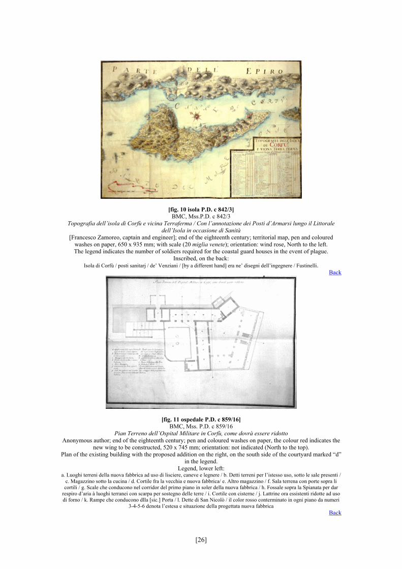
[fig. 10 isola P.D. c 842/3] BMC, Mss.P.D. c 842/3
Topografia dell’isola di Corfù e vicina Terraferma / Con l’annotazione dei Posti d’Armarsi lungo il Littorale dell’Isola in occasione di Sanità
[Francesco Zamoreo, captain and engineer]; end of the eighteenth century; territorial map, pen and coloured washes on paper, 650 x 935 mm; with scale (20 miglia venete); orientation: wind rose, North to the left. The legend indicates the number of soldiers required for the coastal guard houses in the event of plague.
Inscribed, on the back: Isola di Corfù / posti sanitarj / de’ Venziani / [by a different hand] era ne’ disegni dell’ingegnere / Fustinelli.
Back
[fig. 11 ospedale P.D. c 859/16] BMC, Mss. P.D. c 859/16
Pian Terreno dell’Ospital Militare in Corfù, come dovrà essere ridotto Anonymous author; end of the eighteenth century; pen and coloured washes on paper, the colour red indicates the
new wing to be constructed, 520 x 745 mm; orientation: not indicated (North to the top). Plan of the existing building with the proposed addition on the right, on the south side of the courtyard marked “d”
in the legend. Legend, lower left:
a. Luoghi terreni della nuova fabbrica ad uso di lisciere, caneve e legnere / b. Detti terreni per l’istesso uso, sotto le sale presenti / c. Magazzino sotto la cucina / d. Cortile fra la vecchia e nuova fabbrica/ e. Altro magazzino / f. Sala terrena con porte sopra li cortili / g. Scale che conducono nel corridor del primo piano in soler della nuova fabbrica / h. Fossale sopra la Spianata per dar
respiro d’aria à luoghi terranei con scarpa per sostegno delle terre / i. Cortile con cisterne / j. Lattrine ora essistenti ridotte ad uso di forno / k. Rampe che conducono dlla [sic.] Porta / l. Dette di San Nicolò / il color rosso conterminato in ogni piano da numeri
3-4-5-6 denota l’estesa e situazione della progettata nuova fabbrica Back
[26]
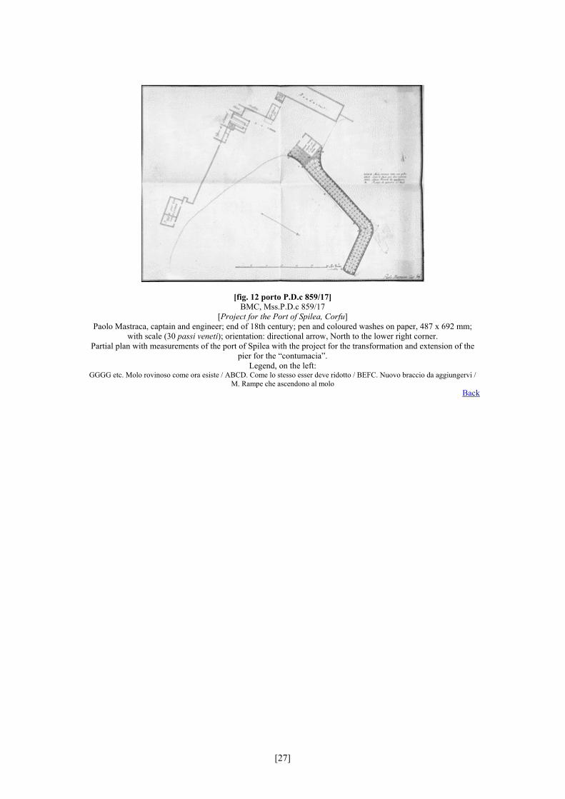
[fig. 12 porto P.D.c 859/17] BMC, Mss.P.D.c 859/17
[Project for the Port of Spilea, Corfu] Paolo Mastraca, captain and engineer; end of 18th century; pen and coloured washes on paper, 487 x 692 mm;
with scale (30 passi veneti); orientation: directional arrow, North to the lower right corner. Partial plan with measurements of the port of Spilea with the project for the transformation and extension of the
pier for the “contumacia”. Legend, on the left:
GGGG etc. Molo rovinoso come ora esiste / ABCD. Come lo stesso esser deve ridotto / BEFC. Nuovo braccio da aggiungervi / M. Rampe che ascendono al molo
Back
[27]
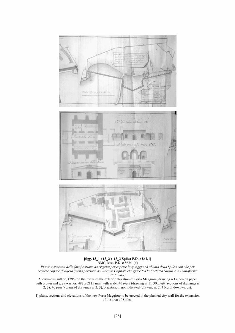
[figg. 13_1 ; 13_2 ; 13_3 Spilea P.D. c 862/1] BMC, Mss. P.D. c 862/1 (a)
Piante e spaccati della fortificazione da erigersi per coprire la spiaggia ed abitato della Spilea non che per rendere capace di difesa quella porzione del Recinto Capitale che giace tra la Fortezza Nuova e la Piattaforma
alli Fondaci Anonymous author; 1795 (on the frieze of the exterior elevation of Porta Maggiore, drawing n.1); pen on paper
with brown and grey washes, 492 x 2115 mm; with scale: 40 piedi (drawing n. 1); 30 piedi (sections of drawings n. 2, 3); 40 passi (plans of drawings n. 2, 3); orientation: not indicated (drawing n. 2, 3 North downwards).
1) plans, sections and elevations of the new Porta Maggiore to be erected in the planned city wall for the expansion
of the area of Spilea.
[28]
Inscription: Pianta della Porta / Prospetto interno della Porta / Profilo tagliato sulla linea AB / Profilo preso sulla linea CD / Prospetto esterno
della Porta
2) plan with measurements of the existing buildings on the esplanade of Spilea with the proposed curtain, bastion and city gate; the detail shows the cross section of the low artillery outworks (gun platform and piazza bassa) at the left corner of the new walls. The plan represents the built area as well the way of the rounds on the new city
walls. Inscription:
Profilo preso sopra AB / Profilo preso sopra CD
3) ground level plan with measurements of the same area as in drawing 2, showing the existing situation and the planned extension of the shores of Spilea.
Legend, lower right: Dichiarazione delle lettere e numeri
A. Piattaforma alli fondaci/ b. Fianco basso / c. Cortina / d. Bastione / e. Tezzone per attrezzi di artiglieria / f. Molo che serve al presente alle barche di contumacia / g. Molo nuovo / h. Cortina / i. Fianco basso sotto la piattaforma di Fortezza Nuova / j. Porta Maggiore / k. Sortite che conducono nè fianchi bassi / a. Recinto della città / b. Basso recinto di Fortezza Nuova / c. Porta Spilea
/ d. Porta murata / 1. Ufficio della Sanità / 2. Chiesa appartenente allo stesso / 3. Quartieri per quelli che vengono dalla vicina terraferma / 4. Luoghi dell’ufficio suddetto / 5. Fondaci nuovo appartenenti alla città / 6. Tezza de’ beccheri / 7. Baracche della
città / 8. Baracca del signor Rodostamo S.r Marco / 9. Bottega del Papà Calagerà / 10. Detta del Papà Gonemi / 11. Casello della decima / 12. Baracche del Nobil Huomo Corner / 13. Dette del papà Mario Bulgari / 14. Baracche del Ragionato Falier / 15.
Dette del signor Mercoran / 16. Dette del Teotochi del Santo / 17. Dette del Giaferro / 18. Dette del Rodostamo / 19. Dette della Beata Vergine di Fortezza Nuova / 20. Dette del Dimitri / 21. Dette del Vivante / 22. Dette del Pieri alla Chieropula / 23. Dette di
Giaculetto / 24. Dette di Giacur / 25. Dette del Vuvà / 26. Dette del Polilà / 27. Dette del Frivoli / 28. Condotti principalli della città / 29. Fondi del signor Spiro Sol / 30. Magazzini de grani de’ privati / 31. Dogana del vino
Back
[29]
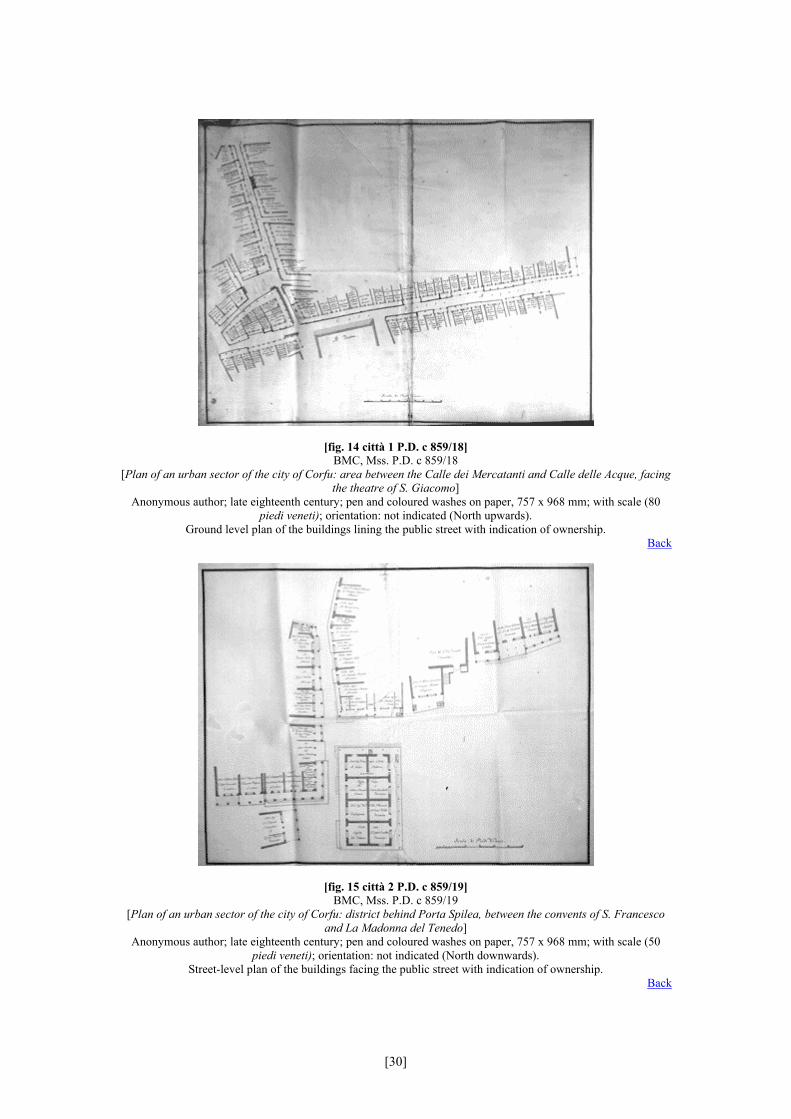
[fig. 14 città 1 P.D. c 859/18] BMC, Mss. P.D. c 859/18
[Plan of an urban sector of the city of Corfu: area between the Calle dei Mercatanti and Calle delle Acque, facing the theatre of S. Giacomo]
Anonymous author; late eighteenth century; pen and coloured washes on paper, 757 x 968 mm; with scale (80 piedi veneti); orientation: not indicated (North upwards).
Ground level plan of the buildings lining the public street with indication of ownership. Back
[fig. 15 città 2 P.D. c 859/19] BMC, Mss. P.D. c 859/19
[Plan of an urban sector of the city of Corfu: district behind Porta Spilea, between the convents of S. Francesco and La Madonna del Tenedo]
Anonymous author; late eighteenth century; pen and coloured washes on paper, 757 x 968 mm; with scale (50 piedi veneti); orientation: not indicated (North downwards).
Street-level plan of the buildings facing the public street with indication of ownership. Back
[30]
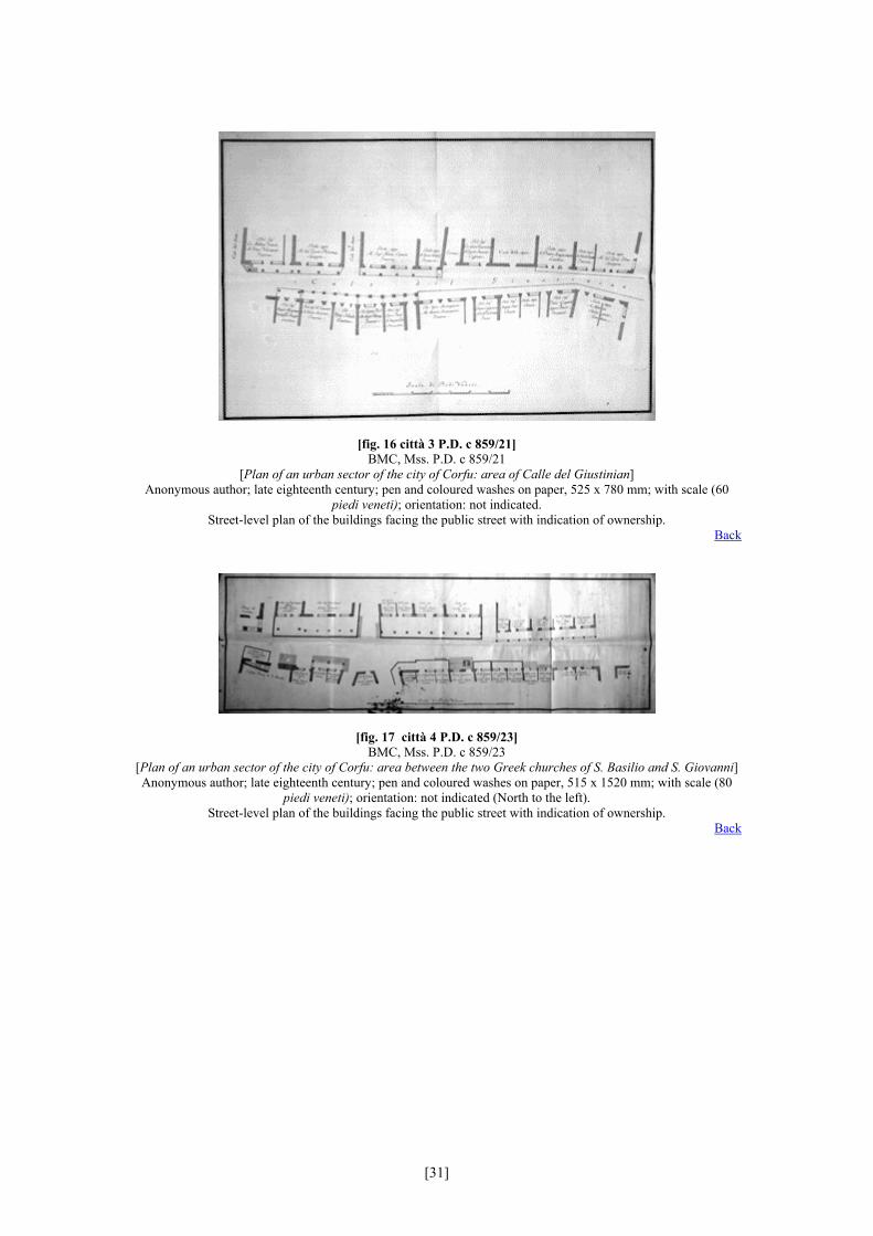
[fig. 16 città 3 P.D. c 859/21] BMC, Mss. P.D. c 859/21
[Plan of an urban sector of the city of Corfu: area of Calle del Giustinian] Anonymous author; late eighteenth century; pen and coloured washes on paper, 525 x 780 mm; with scale (60
piedi veneti); orientation: not indicated. Street-level plan of the buildings facing the public street with indication of ownership.
Back
[fig. 17 città 4 P.D. c 859/23] BMC, Mss. P.D. c 859/23
[Plan of an urban sector of the city of Corfu: area between the two Greek churches of S. Basilio and S. Giovanni] Anonymous author; late eighteenth century; pen and coloured washes on paper, 515 x 1520 mm; with scale (80
piedi veneti); orientation: not indicated (North to the left). Street-level plan of the buildings facing the public street with indication of ownership.
Back
[31]