maple ridge industrial area structure plan
TRANSCRIPT

Maple Ridge Industrial Area Structure Plan
Bylaw 15357, March 8, 2010
Office Consolidation January 2021
Prepared by:
Development Services Urban Planning and Economy
City of Edmonton
Bylaw 15357 (as amended) was adopted by Council in March 2010. In January 2021, this document was consolidated by virtue of the
incorporation of the following bylaws, which were amendments to the original Bylaw 15357.
Bylaw 15357 Approved on March 8, 2010 (to adopt the Maple Ridge Industrial ASP)
Bylaw 17536 Approved on February 29, 2016 (to add a Storm Water Management Facility)
Bylaw 19530 Approved January 26, 2021 (to amend the Maple Ridge Industrial Area Structure Plan (ASP)
to allow for the expansion of the cemetery and the relocation and reconfiguration of a
2.36 hectare public park)
Editor’s Note:
This is an office consolidation edition for the Maple Ridge Industrial ASP, as approved by City Council on
March 8, 2010. This edition contains all amendments and additions to Bylaw 15357. For the sake of
clarity, new maps and a standardized format were utilized in this Plan. All names of City departments have
been standardized to reflect their present titles. Private owner’s names have been removed in accordance
with the Freedom of Information and Protection of Privacy Act. All text changes are noted in the right
margin and are italicized where applicable. Furthermore, all reasonable attempts were made to accurately
reflect the original Bylaws.
This office consolidation is intended for convenience only. In case of uncertainty, the reader is advised to
consult the original Bylaws, available at the office of the City Clerk.
City of Edmonton
Urban Planning and Economy

Bylaw 19530, January 26, 2021

MAPLE RIDGE AREA STRUCTURE PLAN
Maple Ridge Industrial ASP Consolidation
i
TABLE OF CONTENTS (Amended by Editor)
1.0 INTRODUCTION 1 1.1 Background 1 1.2 Purpose 1 1.3 Location and Boundaries 1 1.4 Vision 1 1.5 Plan Goals 2
2.0 EXISTING FEATURES 4 2.1 Development History 4 2.2 Current Zoning 4 2.3 Natural Features 4 2.4 Soils 5 2.5 Topography 5 2.6 Archaeological Significance 5 2.7 Land Ownership 5 2.8 Wells, Pipelines & Utility Rights-of-Way 5
3.0 REGULATORY CONTEXT (Legislation and Policy) 9 3.1 Introduction 9 3.2 Municipal Government Act 9 3.3 Municipal Development Plan (MDP) 9 3.4 Alberta Land Use Framework 9 3.5 Industrial Land Strategy 9 3.6 North Saskatchewan River Valley Area Redevelopment Plan 9 3.7 Natural Area Systems Policy C-531 10 3.8 Natural Connections Strategic Plan – Edmonton’s Integrated Natural Areas Conservation Plan 10 3.9 Water Act 10 3.10 Alberta Environmental Protection and Enhancement Act 10 3.11 Alberta Public Lands Act 10 3.12 Top-of-Bank Policy 11 3.13 Existing Policy Supporting Eco-Industrial Development 11
4.0 DEVELOPMENT CONCEPT 12 4.1 Overview 12 4.2 Business Service Centre 12 4.3 Light Industrial 13 4.4 Medium Industrial 13 4.5 Medium Industrial with Restrictions 13 4.6 Heavy Industrial 14 4.7 Residential 14
4.8 Hurstwood Special Development Area 15
5.0 NATURAL AREAS, PARKS AND OPEN SPACE 18 5.1 Natural Areas and Ecological Network 18 5.2 Habitat Patches 18 5.2.1 Fulton and Goldbar Creeks 18 5.2.2 Natural Areas 19 5.3 Stepping Stones 19 5.3.1 Wetland Areas 20 5.3.2 Parks 20 5.3.3 Storm Water Management Facilities 21
MAPLE RIDGE AREA STRUCTURE PLAN
Maple Ridge Industrial ASP Consolidation
ii
5.4 Corridors 22 5.4.1 Power Corridor 22 5.4.2 Rail Line Rights-of-Way 22 5.4.3 Pipeline Rights-of-Way 22 5.4.4 Other Utility Rights-of-Way 22
6.0 TRANSPORTATION 25 6.1 Overview 25 6.2 Transportation Master Plan 25 6.3 Transportation Network 25
6.3.1 Arterial Roadways 25 6.3.2 Internal Roadways 26 6.3.3 Meridian Street 26 6.3.4 Private Railway 27 6.3.5 Roadway Standards 27
6.4 Transit Service 28 6.5 Pedestrian and Bicycle Linkages 28
6.5.1 Sidewalks 29 6.5.2 Multi-use Trails 29 6.5.3 Top of Bank Roadway and Multi-Use Trail 29 6.6 Arterial Road Assessments 30
7.0 SERVICING 32 7.1 General 32 7.2 Sanitary Sewer 32 7.3 Storm Water Management 33
7.3.1 Land Drainage Utility Credit 33 7.4 Water Service 34 7.5 Staging 34
8.0 ECO-INDUSTRIAL DEVELOPMENT GUIDELINES 41 8.1 Eco-Industrial Framework 41 8.2 Principles of Eco-Industrial Development 41 8.3 Development Guideline Goals and Objectives 42 8.4 Development Guidelines 43 List of Figures
Figure 1 – Location Plan ...................................................................................................................................... 3
Figure 2 – Existing Site Features ......................................................................................................................... 7
Figure 3 – Existing Ecological Network ................................................................................................................ 8
Figure 4 – Development Concept ....................................................................................................................... 16
Figure 5 – Proposed Ecological Network ............................................................................................................ 23
Figure 6 – Open Space and Pedestrian Connections Plan .................................................................................. 24
Figure 7 – Transportation Plan .......................................................................................................................... 31
Figure 8 – Available Sanitary Servicing ............................................................................................................. 36
Figure 9 – Ultimate Sanitary Servicing .............................................................................................................. 37
Figure 10 – Storm Water Servicing .................................................................................................................... 38
Figure 11 – Water Servicing............................................................................................................................... 39
Figure 12 – Staging ............................................................................................................................................ 40
List of Tables Table 1 – Eco-Industrial Supporting Documents ................................................................................................ 13

MAPLE RIDGE AREA STRUCTURE PLAN
Maple Ridge Industrial ASP Consolidation
iii
Table 2 –Land Use and Population Statistics ..................................................................................................... 17
List of Appendices Appendix 1 – References ................................................................................................................................... 53

MAPLE RIDGE AREA STRUCTURE PLAN
Maple Ridge Industrial ASP Consolidation
1
1.0 INTRODUCTION
1.1 Background
In accordance with the City’s Industrial Land Strategy the Maple Ridge Industrial area will be developed to help support
growing industrial land demand. Development challenges within the area include a lack of available servicing and storm
water management as well as the coordination of transportation routes. This plan provides a comprehensive planning
framework to resolve these issues.
1.2 Purpose
The Maple Ridge Industrial Area Structure Plan describes how 1,123 hectares of developed and undeveloped industrial
land located in southeast Edmonton will evolve into an efficient and orderly industrial business community. The ASP has
been prepared on behalf of the City of Edmonton in an effort to promote and encourage timely and orderly development
and completion of the Maple Ridge Industrial Area.
The purpose of this document is to provide a framework to guide the development of Maple Ridge Industrial Area. This
Plan will address planning issues in a comprehensive manner to effectively coordinate servicing and transportation
infrastructure together with a sensitive integration of natural features relevant to the area. Additionally, this Plan seeks
to introduce policy and guidelines to help create successful, innovative and environmentally responsible industrial
development.
More specifically, this Area Structure Plan (ASP) will outline:
Specific land uses and their respective allocations in the Plan area
The manner in which environmental features and natural areas will be incorporated
A framework to support eco-industrial development principles
Infrastructure requirements and their provisions
Phasing of development
1.3 Location and Boundaries
The Maple Ridge Industrial Area is located in southeast Edmonton (see Figure 1, Location Plan) and is bounded by 34
Street to the west, Sherwood Park Freeway to the north, Highway 216 to the east, and Whitemud Drive to the south.
The Maple Ridge Industrial ASP includes the Southeast Industrial, Maple Ridge and Maple Ridge Industrial
neighbourhoods.
To the north of the plan area is the Sherwood Park Freeway and lands under the jurisdiction of Strathcona County. These lands are
largely heavy and medium industrial in nature. To the east is Highway 216 which is located in the Transportation and Utility
Corridor (TUC). Highway 216 is slated to become part of Anthony Henday Drive. To the south across Whitemud Drive is a
residential area governed by the Meadows Area Structure Plan. To the west is the Pylypow Industrial area.
1.4 Vision
The Maple Ridge Industrial area provides for the development of a high quality urban light and medium industrial park
that incorporates significant natural features and meets the growing needs of Edmonton’s industrial business
community.

MAPLE RIDGE AREA STRUCTURE PLAN
Maple Ridge Industrial ASP Consolidation
2
1.5 Plan Goals
To support the Maple Ridge Industrial ASP vision, the goals of this plan are:
To create a comprehensive plan that describes uses, designs and strategies for appropriate development of
light and medium industrial development within the Plan Area;
To address the servicing, transportation and open space requirements and constraints associated with the
Maple Ridge Industrial area;
To encourage the responsible and sustainable use of the land and the environment through the provision of
eco-industrial design principles to the fullest extent possible while having due regard for existing City of
Edmonton development standards.

MAPLE RIDGE AREA STRUCTURE PLAN
Maple Ridge Industrial ASP Consolidation
3
Figure 1 – Location
MAPLE RIDGE AREA STRUCTURE PLAN
Maple Ridge Industrial ASP Consolidation
4
2.0 EXISTING FEATURES
2.1 Development History
Prior to being annexed by the City of Edmonton in 1982, the Maple Ridge Industrial Area was part of Strathcona County
and was designated for industrial development west of 17 Street, agricultural in the southern part of the Plan area east
of 17 Street, and rural residential in the northern part of the Plan area east of 17 Street. Although much of the Plan area
was undeveloped at the time of annexation, there were some isolated pockets of development contained within it. Most
noteworthy are the country residential community of Hurstwood and the Maple Ridge mobile home park. (See Figure 2,
Existing Site Features).
Under the City of Edmonton’s jurisdiction, the entire area became designated for future industrial development as part
of the General Municipal Plan, Bylaw 9076, adopted in November 1990. This shift left the residential component of the
area as non-conforming uses. The subsequent MDP, Plan Edmonton, Bylaw 11777 (as amended), approved August 31,
1998 supported the future industrial designation.
In December of 2003, an amendment was made to the City of Edmonton’s Municipal Development Plan (MDP) under
Bylaw 13541 to designate the existing Maple Ridge mobile home park as a suburban area. As a result, the Maple Ridge
mobile home park gained residential status in the City of Edmonton. An expansion to the Maple Ridge mobile home park
was approved by Bylaw 13509 in July of 2004 which re-designated the expansion area to Suburban use from Business
and Employment Area. The 30 hectare Hurstwood country residential development remains under the Business and
Employment Area designation in the MDP and is considered a legal non-conforming use. The current Bylaw 14978
supports the Plan area as Business and Employment and continues to recognize the 60 hectare Maple Ridge mobile home
park as Suburban.
Since the designation of the Maple Ridge area for industrial use, there has been some new development, primarily in the
northern portion of the Plan area along 76 Avenue where the extension of servicing was the least difficult. The southern
portion of the Plan area has experienced difficulty with servicing which has resulted in attracting such uses as pipe
storage and other uses with extensive land requirements, due to their lower servicing needs.
2.2 Current Zoning
In addition to the approximately 90 hectares of residential development (30 of which is expected to transition to
industrial uses over the long term) within the 1,123 hectare plan area, approximately 661 hectares have been zoned
and developed with some form of industrial development while approximately 273 hectares are undeveloped Greenfield
sites. Much of the developed lands (along the arterials and collectors) would be expected to transition in the context of
the long term vision of this plan.
2.3 Natural Features
Much of the Maple Ridge area has either been developed or been cleared for agricultural purposes; however, it does
contain several natural features of varying size and ecological significance. Several key natural features were
identified by Spencer Environmental Ltd. who completed two reports with respect to the natural features within the
Maple Ridge Plan area: the Biophysical Network Analysis of Maple Ridge - Interim Recommendations Report (December, 2007) and the Biophysical Network Analysis of Maple Ridge – Proposed Development Impact Analysis and Recommendations for Future Development (April, 2009).
The first report identified a number of key natural features that include the following:
Goldbar and Fulton Creeks, two tributaries of the North Saskatchewan River.
Several small remnant woodlands (the largest measuring 4.6 ha in size.)

MAPLE RIDGE AREA STRUCTURE PLAN
Maple Ridge Industrial ASP Consolidation
5
Many small wetlands, including two permanent wetlands.
Several well established shelterbelts along property lines.
Semi-natural areas along the rail line and within power line rights-of-way.
These natural features provide variety in wildlife habitat and include riparian, woodland, wetland and open field areas.
These areas are also described as habitat patches, natural and semi-natural stepping stones and corridors that together
make up an ecological network as illustrated in Figure 3 – Existing Ecological Network.
The reports recommended a number of natural features for retention in the Plan area including Fulton Creek and
Goldbar Creek, the Maple Ridge Natural Area (SE 238) and the Highway 216 - Sherwood Park Cloverleaf Natural Area (SE
244). The creeks were recommended for retention due to their significant hydrological features. The two natural areas
were recommended for retention due to their higher levels of ecological significance. Six additional sites were identified
as having moderate ecological integrity to be considered for retention, should they be sustainable in a future developed
context The natural features identified for retention are further discussed in Section 5 Open Spaces and Natural Areas
and are reflected in the development concept.
2.4 Soils
According to the “Urban Geology of Edmonton” Bulletin 32 of the Alberta Research Council (1975), the area soils are
generally characterized by tills made up of sand and clay, which is overlaying glacial sand and gravel. These soil
conditions are typical of the Edmonton region. There are no known development constraints due to the condition of the
soils in this area.
2.5 Topography
The site is gently rolling with several low-lying areas. There is also some localized sloping into Goldbar and Fulton
Creeks, which run through the Plan area and into the North Saskatchewan River. Overall, the planning area drops from
the southeast to the northwest, ranging in elevation from approximately 720 m to 680 m.
2.6 Archaeological Significance
A Historical Resources Overview (HRO) was undertaken for the Plan area by Bison Historical Services in May, 2007.
Several historically significant sites had been previously found in the vicinity of the Maple Ridge Industrial Plan area,
but none of significance within the Plan area itself. That said, Alberta Culture and Community Spirit have identified areas
of high archeological potential, including the area by Fulton Creek in Sections 17 and 18-52-24-W4M and any other
undisturbed areas with native vegetation. A Historical Resources Impact Assessment (HRIA) will be required prior to
development in these areas. This Assessment is a requirement of pre-construction due diligence for crossings or
development in the less disturbed portion of the creek area.
2.7 Land Ownership
Although most land is privately held, there are also a number of parcels of land owned by the City of Edmonton,
including an operating snow management facility in the south central portion of the Plan area. The major undeveloped
landholdings in Maple Ridge are held by four corporate land owners (Mullen Group, Cominco, Baramy Holdings, Integrate
Management and Realty Inc.), and the City of Edmonton.
2.8 Wells, Pipelines & Utility Rights-of-Way
There are two abandoned wells located in the Maple Ridge Industrial Area. The first is located in the Maple Ridge
mobile home park and the other in the vicinity of 17 Street and Whitemud Drive, as shown on Figure 2, Existing Site
Features. Prior to development in these areas the actual location of the abandoned wells will need to be confirmed and
MAPLE RIDGE AREA STRUCTURE PLAN
Maple Ridge Industrial ASP Consolidation
6
access requirements accommodated.
The Maple Ridge Industrial Area has a number of pipeline corridors which include some very significant pipelines
passing through and near it. These pipeline rights-of-way (ROWs) are largely located between 34 Street and 17
Street with two significant corridor ROWs very close to the Maple Ridge Mobile Home Park.
HVP or High Vapour pressure refers to pipelines that carry liquids that will rapidly change to gas when released. The
release is the safety issue that needs to be considered in planning the area. Emergency services staff must be able to
safely evacuate the public and workers. Setbacks need to be carefully applied in regard to all of these pipelines which
have been in place for many years, probably up to 50-60 years.
The ROWs are located generally as shown on Figure 2, Existing Site Features. Generally the ROWs run parallel to 76
Avenue and to 34, 17 and Meridian Streets; however some of the ROWs bisect the plan area as indicated in Figure 2.
Generally the substances include oil, crude oil, condensate, diesel fuel, gasoline, natural gas, propane and ethane.
Further information can be obtained from the Edmonton and Area Pipelines and Utility Operators Committee (EAPUOC).
See www.eapuoc.ca for additional information.
A major powerline corridor runs north/south in the west plan area between 34 Street and 17 Street and another runs
east/west from Pylypow west of 34 Street connecting to the north/south corridor. Future development adjacent to the
powerline rights-of-way will be required to follow relevant regulations and policy.

MAPLE RIDGE AREA STRUCTURE PLAN
Maple Ridge Industrial ASP Consolidation
7
Figure 2 – Existing Site Features (Bylaw 19530, January 26, 2021)

MAPLE RIDGE AREA STRUCTURE PLAN
Maple Ridge Industrial ASP Consolidation
8
Figure 3 – Existing Ecological Network (Bylaw 19530, January 26, 2021)

MAPLE RIDGE AREA STRUCTURE PLAN
Maple Ridge Industrial ASP Consolidation
9
3.0 REGULATORY CONTEXT (Legislation and Policy)
3.1 Introduction
The following provincial and municipal regulatory documents are relevant to the Maple Ridge Industrial Area Structure
Plan.
3.2 Municipal Government Act
Area structure plans are regulated by Section 633 of the Municipal Government Act, which identifies the key parameters
that must be addressed as a part of an area structure plan bylaw. These parameters include: the development sequence;
the proposed land uses and densities for the area, the general locations of public utilities and transportation systems;
and any other factors that Council deems necessary. An area structure plan is a statutory document, and must be
consistent with all higher order plans, which include the Municipal Development Plan and the Alberta Land Use
Framework.
3.3 Municipal Development Plan (MDP)
The Maple Ridge Industrial ASP conforms to the MDP which identifies the subject lands for industrial use and the mobile
home park for residential use.
3.4 Alberta Land Use Framework
The Alberta Land Use Framework has recently been adopted by the Province and consists of seven basic strategies to
improve land-use decision-making in Alberta, such as developing regional land use plans and developing a strategy for
stewardship of lands in Alberta.
The Alberta Land Use Framework sets out an approach to manage public and private lands and natural resources to
achieve Alberta’s long-term economic, environmental and social goals. It provides a blueprint for land-use management
and decision-making that addresses Alberta’s growth pressures.
3.5 Industrial Land Strategy
Edmonton’s Industrial Land Strategy (ILS) was approved by the City of Edmonton on August 27th, 2002. The goal of the
strategy is to increase the prosperity of the City and its citizens by accommodating the growth and development of Edmonton’s existing industrial businesses and attracting new ones. It identifies the Maple Ridge Industrial Plan area as
a part of the larger industrial area in the southeast, which includes industrial lands as far north as 101 Avenue and
south to the City boundary.
By developing the Maple Ridge ASP, the City of Edmonton promotes its Industrial Land Strategy by facilitating industrial
planning activities to encourage development and redevelopment of industrial areas in an orderly, cost-effective way,
and to ensure varied industrial development opportunities are available.
3.6 North Saskatchewan River Valley Area Redevelopment Plan
The area of the North Saskatchewan River Valley Area Redevelopment Plan (NSRVARP), Bylaw 7188 as amended, includes
Fulton Creek and the associated ravine within the Maple Ridge ASP and the policies of the River Valley Area
Redevelopment Plan shall apply to Fulton Creek and its ravine. No policy of the Maple Ridge Area Structure Plan will
supersede the policies of the River Valley Bylaw.

MAPLE RIDGE AREA STRUCTURE PLAN
Maple Ridge Industrial ASP Consolidation
10
3.7 Natural Area Systems Policy C-531
Policy C531 was adopted by the City of Edmonton in June 2007, and represents the City’s approach to natural area
management. The policy commits the City to balance ecological and environmental considerations of a project with
economic and social considerations during the City’s decision making. The policy also states the City’s commitment to
conserving, protecting and restoring natural uplands and riparian areas as an integrated and connected system of
natural areas throughout the City.
Pursuant to this policy, Natural Site Assessments are required for all new plans and major plan amendments that may
impact any identified natural areas. In addition to exploring significant environmental issues, these Natural Site
Assessments will also explore measures to mitigate development impacts. (Note: Spencer Environmental Ltd. completed two reports with respect to the natural features within the Maple Ridge Plan area: The Biophysical Network Analysis of Maple Ridge - Interim Recommendations Report (December, 2007) and The Biophysical Network Analysis of Maple Ridge – Proposed Development Impact Analysis and Recommendations for Future Development (April, 2009). These reports, prepared prior to terms of reference being set for Natural Site Assessments, generally satisfy Steps 1 and 2 as set out in
the Guidelines for Natural Site Assessments).
3.8 Natural Connections Strategic Plan – Edmonton’s Integrated Natural Areas Conservation Plan
Completed in June 2007, the Natural Connections Strategic Plan (NCSP) outlines the City of Edmonton’s outcome-based,
ecological network approach for strengthening conservation planning for natural areas and systems. The NCSP
recognizes that the City’s ecological network must be considered from a regional perspective and that connectivity is
vital to biodiversity and ecological functions. While the 2006 State of Natural Areas Report, which preceded the NCSP and
identified several structural components for Edmonton’s ecological network which included regional biological corridors,
biodiversity core areas, linkages and the underlying urban matrix, the NCSP outlines the guiding principles, system
outcomes and strategies that are necessary to ensure Edmonton’s ecological network is conserved and protected. The
NCSP is also supported by the Natural Area Systems Policy (C-531) outlined above.
3.9 Water Act
The Water Act of Alberta stipulates that the Government of Alberta may require mitigation for damage to, or the loss of,
wetlands. Therefore any change to movement or destruction of wetlands within the Plan area may be subject to
sanctions under this provision.
The Government of Alberta also requires municipalities to address the quality of storm water discharged to
watercourses. The Province has accepted storm water retention as a means of improving the quality of runoff water.
Where damage to or loss of wetlands is contemplated by a development, a compensation plan pursuant to the
provisions of the Water Act will be required prior to subdivision approval.
3.10 Alberta Environmental Protection and Enhancement Act
The purpose of the Alberta Environmental Protection and Enhancement Act (AEPEA) is to support and promote the
protection, enhancement and wise use of the environment. Under AEPEA, all new storm water management facilities
must be registered. At the detailed design phase for each new facility, it will be the responsibility of the proponent to
register any new storm water management facilities.
3.11 Alberta Public Lands Act
Pursuant to Section 3 of the Public Lands Act, the Province owns the bed and shore of all water bodies that are
permanent and naturally occurring. This includes permanent and naturally-occurring wetlands and water courses. That
said, it is possible for title to the bed and shore of a water body to be granted to a private landowner. As well,
MAPLE RIDGE AREA STRUCTURE PLAN
Maple Ridge Industrial ASP Consolidation
11
development within a Crown-owned wetland or water body can be authorized under the Act. In this instance
compensation for any loss would be required and any wetlands or water bodies created as compensation must revert to
Crown ownership.
Within the Maple Ridge Plan area it is anticipated that Fulton Creek, Goldbar Creek and possibly the wetland component
of the Maple Ridge Natural Area (SE 238) may be claimed by the Crown as permanent water bodies. Public lands that
have been claimed by the Crown are generally defined and subdivided out at the subdivision stage. It will be the
responsibility of the proponent of any development to determine whether or not the Crown has a claim on any water
bodies. Where land contains water bodies or wetlands, a determination as to the Crown’s interest in these water bodies
under the Public Lands Act will be required prior to subdivision approval.
3.12 Top-of-Bank Policy
The purpose of Top-of-Bank Policy is to ensure an open space between the North Saskatchewan River Valley and Ravine
System and urban development and to provide public access to this system. Lands within the ASP will be subject to the
Policies and Bylaws regarding Top-of-Bank in place at the time of development.
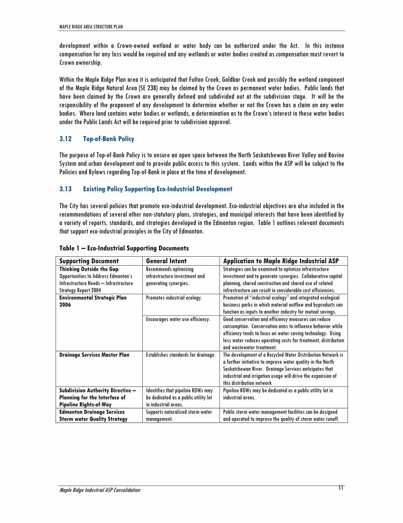
3.13 Existing Policy Supporting Eco-Industrial Development
The City has several policies that promote eco-industrial development. Eco-industrial objectives are also included in the
recommendations of several other non-statutory plans, strategies, and municipal interests that have been identified by
a variety of reports, standards, and strategies developed in the Edmonton region. Table 1 outlines relevant documents
that support eco-industrial principles in the City of Edmonton.
Table 1 – Eco-Industrial Supporting Documents
Supporting Document General Intent Application to Maple Ridge Industrial ASP Thinking Outside the Gap:
Opportunities to Address Edmonton’s
Infrastructure Needs – Infrastructure
Strategy Report 2004
Recommends optimizing
infrastructure investment and
generating synergies.
Strategies can be examined to optimize infrastructure
investment and to generate synergies. Collaborative capital
planning, shared construction and shared use of related
infrastructure can result in considerable cost efficiencies.
Environmental Strategic Plan
2006
Promotes industrial ecology. Promotion of “industrial ecology” and integrated ecological
business parks in which material outflow and byproducts can
function as inputs to another industry for mutual savings.
Encourages water use efficiency. Good conservation and efficiency measures can reduce
consumption. Conservation aims to influence behavior while
efficiency tends to focus on water-saving technology. Using
less water reduces operating costs for treatment, distribution
and wastewater treatment.
Drainage Services Master Plan Establishes standards for drainage. The development of a Recycled Water Distribution Network is
a further initiative to improve water quality in the North
Saskatchewan River. Drainage Services anticipates that
industrial and irrigation usage will drive the expansion of
this distribution network
Subdivision Authority Directive –
Planning for the Interface of
Pipeline Rights-of-Way
Identifies that pipeline ROWs may
be dedicated as a public utility lot
in industrial areas.
Pipeline ROWs may be dedicated as a public utility lot in
industrial areas.
Edmonton Drainage Services
Storm water Quality Strategy
Supports naturalized storm water
management.
Public storm water management facilities can be designed
and operated to improve the quality of storm water runoff.

MAPLE RIDGE AREA STRUCTURE PLAN
Maple Ridge Industrial ASP Consolidation
12
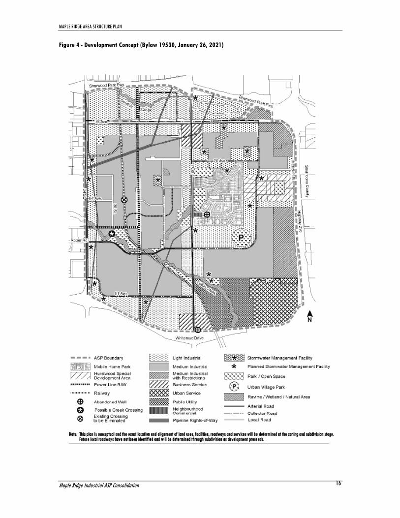
4.0 DEVELOPMENT CONCEPT
4.1 Overview
The development concept for the Maple Ridge Industrial ASP supports the vision and goals of the plan and is
conceptualized in Figure 4, Development Concept. The Plan area will consist of business service development, light and
medium industrial development and the continuation of current residential uses within the Maple Ridge mobile home
park. The Plan area will be punctuated by park and open spaces providing linkages within the plan area and to outside
connections through the Edmonton multi-use trail system.
The ASP is intended to facilitate responsible industrial development that accommodates sustainable practices and
efficient infrastructure systems. The Maple Ridge Industrial Area Structure Plan development concept proposes to
facilitate this in the following ways:
By providing guidance and direction to the patterns of development within the Plan area;
By providing policy to transition the Hurstwood country residential area to industrial use;
By providing a transportation network that meets the needs of future industrial business owners in southeast
Edmonton;
By incorporating the elements of natural environment that have been identified as being environmentally
significant.
Proposed land use statistics for the development concept are outlined in Table 2.
Each attribute of the development intended for the Plan area will be discussed, in order to provide direction for the
future growth of this industrial area.
4.2 Business Service Centre
Business Service areas have been established in the Plan in locations of higher visibility and along the major
intersections of 76th Avenue and Whitemud Drive along 17th Street, although access limitations may exist near major
intersections. Possible uses in these areas could include equipment rentals, business support services, banks, small
food service establishments, personal services, health services, convenience commercial, service stations and gas bars
which would be conveniently accessible to the employees in this area. This will facilitate the function of the industrial
development of the area and provide accessible commercial amenities for employees. This type of development is
intended to be small in scale ancillary to the industrial functions in the area.
Objective: To provide some limited commercial uses that are intended to support the industrial businesses located
in their vicinity.
Policy 4.2.1 Commercial developments in the Business Service Centre area should serve the local Maple Ridge Industrial area. Policy 4.2.2 Prior to development within the vicinity of the abandoned well site located at the NE intersection of Whitemud Drive and 17 Street within an identified Business Service area, location and access requirements for the well site shall be accommodated. Implementation: Development in the Business Service designation in the Plan area may include Business Industrial development primarily under the regulations of the (IB) Industrial Business Zone.

MAPLE RIDGE AREA STRUCTURE PLAN
Maple Ridge Industrial ASP Consolidation
13
4.3 Light Industrial
Much of Maple Ridge Industrial Area will be comprised of businesses that fall under the (IL) Light Industrial Zone. Light
industrial uses do not create nuisance factors outside of their building envelopes. Uses can include business offices,
indoor value-added manufacturing such as electronics, radio stations, print shops, and other similar business types. This
industrial land use is particularly appropriate in Maple Ridge, due to the large area adjacent to residential development.
Until recently, light Industrial development was typically found in IB zoning, which also provided a host of commercial
development options. These commercial developments benefited from arterial road access and came to dominate the
available light industrial lands in many industrial parks. This meant that there was insufficient supply of available land
for more business oriented light industrial uses than had originally been anticipated by the plans for these industrial
parks. In recent years, this issue has been addressed by providing zoning that more accurately fits the true industrial
uses more closely in order to protect the supply of light industrial lands.
Objective: To establish a high standard of appearance along major roadways and establish industrial uses that do not create nuisance factors outside of their building envelopes around sensitive land uses. Policy 4.3.1 Light Industrial uses shall be located along arterial roads, major internal traffic corridors and around the existing mobile home park. Direct access to individual parcels may be limited. Joint accesses, cross lot accesses and other options for combined access locations will be encouraged where possible including consolidation of smaller parcels, particularly along the arterial road segments. Implementation: Light industrial development will be accommodated through application of the (IL) Light Industrial Zone. Administration will investigate with property owners, the potential of rezoning current IB zoned properties in the northern portion of the plan area which do not conform to Figure 4 – Development Concept.
4.4 Medium Industrial
Medium Industrial is the most extensive industrial use that will be permitted within the Maple Ridge Industrial Plan
area. Medium industrial uses may create nuisance factors that extend outside of their building, but may not extend
beyond the lot boundaries. Medium Industrial uses have been located to keep distance between them and residential
users to ensure that these two uses do not intrude on one another. Medium industrial designations have been placed
along roadways and in areas with less direct visual impact.
Objective: To locate medium industrial uses at a distance from residential uses and away from major traffic roadways to minimize any potential impacts. Policy 4.4.1 Medium industrial uses shall be located in interior locations within the plan area. Implementation: Medium industrial development will be accommodated through application of the (IM) Medium Industrial Zone.
4.5 Medium Industrial with Restrictions
The lands abutting Meridian Street, which runs parallel to Highway 216, are the least accessible relative to the whole
plan area therefore they have been identified for medium industrial use; however given the adjacency to the highway
corridor, added visual control is warranted.
Objective: To ensure an appropriate standard of appearance for properties abutting Meridian Street.

MAPLE RIDGE AREA STRUCTURE PLAN
Maple Ridge Industrial ASP Consolidation
14
Policy 4.5.1 Site design of lots along the highway corridor shall provide high quality visual appeal through screening and enhanced building facades. Implementation: The Development Officer shall ensure that development applications provide visual screening from the highway corridor for any outdoor yards or storage through landscaping and/or attractive fencing and/or enhanced building facades. The Development Officer shall apply all appearance standards, yard and landscaping requirements for properties abutting Meridian Street as identified in Figure 4, Development Concept. Further, amendments to the Zoning Bylaw that enhance these standards shall be advanced by the Planning and Development Department.
4.6 Heavy Industrial
The Plan area is situated in an area that is in reasonably close proximity to residential housing. The residential
community of The Meadows exists to the south, country residential properties within Strathcona County exist to the east
and the Maple Ridge mobile home park is situated within the Plan area itself. The proximity of these residential uses to
the Plan area prohibits the inclusion of any heavy industrial uses or activities within the Plan area.
Objective: To minimize the potential for hazardous risk and nuisances within the plan area. Policy 4.6.1 Heavy industrial zones shall not be permitted within the Maple Ridge Industrial Area Structure Plan area.
4.7 Residential
The Plan supports retention of the Maple Ridge mobile home park which is recognized in the MDP and is zoned (RMH)
Residential Mobile Home Zone. There is also a neighbourhood commercial site within this development. Outside of the
mobile home park, no new residential areas will be permitted anywhere the Plan area. The Maple Ridge Industrial ASP
supports the permanent screening and buffering of the mobile home park from industrial development.
Objective: To establish the majority of the plan area as industrial. Policy 4.7.1 No new residential development shall be permitted anywhere within the Plan area beyond that which is already approved. Policy 4.7.2 Prior to any redevelopment within the vicinity of the abandoned well site located in the southwest area of the mobile home park, location and access requirements for the well site shall be accommodated. Implementation: New residential areas are not to be considered within the Maple Ridge Industrial Area Structure Plan.
Objective: To ensure attention is given to the interface between residential and industrial uses. Policy 4.7.3 All new developments abutting existing residential areas shall provide adequate screening and buffering from the residential areas. Industrial development should be separated from residential development through the use of a landscaped area. Implementation: The Development Officer will apply all appearance standards, yard and landscaping requirements for properties adjacent to residential as required in the Zoning Bylaw. For example, trees and shrubs should be oriented towards the

MAPLE RIDGE AREA STRUCTURE PLAN
Maple Ridge Industrial ASP Consolidation
15
residential development along adjoining property lines while loading and storage facilities should be located away from the adjoining residential property line. Buffering and screening may also be a requirement of subdivision.
4.8 Hurstwood Special Development Area
In order to recognize the unique challenges of the existing country residential area of Hurstwood it has been identified
as the Hurstwood Special Development Area and is expected to transition from residential to industrial in the long term.
The policy is intended to guide that transition.
Objective: To transition the Hurstwood area to industrial by allow existing residential uses to be retained while encouraging industrial development that is compatible in nature to remaining residential lots and ensuring a high standard of visual appeal along Highway 216. Policy 4.8.1 Residential and home based business uses within the Hurstwood Special Development Area may be recognized as permitted uses; however, no increase in the number of residential lots shall be permitted. Policy 4.8.2 Industrial uses may be permitted within the Hurstwood Special Development Area and shall be compatible with existing adjacent residential uses. Policy 4.8.3 Future industrial developments within the Hurstwood Special Development Area shall be serviced to City of Edmonton standards for roads and sewers and shall have a service connection for potable water. Policy 4.8.4 Site design of lots along the highway corridor (north and south lots abutting 66 Avenue and/or the north and south boundaries of Hurstwood) shall provide high quality visual appeal through screening and enhanced building facades. Implementation: These policies shall be implemented through the use of a Direct Control (DC1) provision for the Hurstwood Special Development Area.
The long term vision of the plan is to see the Hurstwood country residential community transition over time to industrial
uses; however, it could remain with residential uses for some time. The plan supports rezoning to (DC1) Direct Control
through individual or collective efforts of the owners. The Planning and Development Department will facilitate a DC1
rezoning initiative for the community. The DC1 will identify the regulations under which residential and/or industrial
uses may continue and what requirements would be necessary for redevelopment to industrial uses according to the
above noted policies.
MAPLE RIDGE AREA STRUCTURE PLAN
Maple Ridge Industrial ASP Consolidation
16
Figure 4 - Development Concept (Bylaw 19530, January 26, 2021)
MAPLE RIDGE AREA STRUCTURE PLAN
Maple Ridge Industrial ASP Consolidation
17
Table 2
MAPLE RIDGE INDUSTRIALAREA STRUCTURE PLAN
LAND USE AND POPULATION STATISTICS
Bylaw 17536
Amended February 29, 2016
Area (ha) % of GDA
Gross Area 1123.1 Environmental Reserve 20.9 Rail Line 16.1 Powerline Right-of-Way 18.4 Arterial Roadways 24.7 Urban Services 45.6
Gross Developable Area 997.4
Parks 44.1 Existing 24.5
Proposed 19.6
Roadways 55.6
Public Utility 96.6 Public Utility 29.2 Storm Water Management Facilities 43.0
Snow Dump 24.4
Total 196.3 19.7%
Net Developable Area 801.1 80.3%
Maple Ridge Mobile Home Park 60.5 6.1%
Hurstwood Special Development Area 28.3 2.8%
Neighbourhood Commercial 0.7 0.1%
Light Industrial 278.4 27.9%
Business Service 22.9 2.3%
Medium Industrial 357.2 35.8%
Medium Industrial with Restrictions 53.1 5.3%
Total 801.1 80.3%
RESIDENTIAL LAND USE AND POPULATION STATISTICS
Maple Ridge Mobile Home Park
60.5 ha
1,545 population (Source: 2006 Census of Canada)

MAPLE RIDGE AREA STRUCTURE PLAN
Maple Ridge Industrial ASP Consolidation
18
5.0 NATURAL AREAS, PARKS AND OPEN SPACE
5.1 Natural Areas and Ecological Network
The Maple Ridge Industrial ASP supports the City’s Natural Areas Conservation Plan (June 2007) as it recognizes portions
of the existing ecological network and seeks to retain its ecological function within an urban development context. The
Maple Ridge ecological network consists of the following integral components:
Habitat Patches (Biodiversity Core Areas): Including the riparian zones along Fulton Creek and Goldbar Creek,
and Natural Areas SE 238 and SE 244;
Stepping Stones: Natural and semi-natural areas including a number of existing and proposed parks and storm
water management facilities, and the existing cemetery; and
Corridors: Natural and semi-natural linear linkages including linear parks, pedestrian linkages, the private corporation rail line and utility corridors.
Each of these components must be maintained and are planned for inclusion in the Plan area in order to ensure the
establishment and sustainability of the ecological network. The principle habitat patches, stepping stones and
corridors of the proposed ecological network are identified in Figure 5, Proposed Ecological Network.
5.2 Habitat Patches
Based on the recommendations of the Biophysical Network Analysis of Maple Ridge - Proposed Development Impact Analysis and Recommendations for Future Development (March 2009), prepared by Spencer Environmental Ltd., the
above noted components, as identified on Figure 5 – Proposed Ecological Network, were incorporated into the plan. The
Spencer report provided an assessment of the potential impact of the proposed development concept on the natural
features and biophysical network of the Plan area. The report stated that the main components of the ecological
network, Fulton Creek and its associated riparian area, Natural Area SE 244 and Natural Area SE 238, the most
biologically diverse site in the planning area, would not be adversely affected by future development and could be
expected to retain much of their current capacity and ecological function as habitat patches.
The report also identified six sites as having moderate ecological integrity. Of these, Site ‘A’ (see Figure 3 – Existing
Ecological Network), a parcel of grassland which provides a habitat patch for deer and coyote, was determined to have
the highest priority ranking given its size and its nearness to Fulton Creek. The development concept does not provide
for retention of Site ‘A’ for two main reasons: first, the objectives of the plan indicate this site is equally well-suited to
industrial development; and second, reserves have already been taken for this parcel which would mean it could only be
acquired through purchase. It is also noted that additional park space has been identified for retention immediately
adjacent to Fulton Creek in this vicinity.
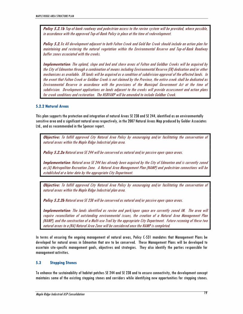
5.2.1 Fulton and Goldbar Creeks
This plan supports the protection and integration of the ravine and upland areas of Fulton Creek and Goldbar Creek
which are recognized in the development concept. Given some of the use activity that has occurred adjacent to the
creeks, environmental clean-up and/or restoration by the owner or developer may be required.
Objective: To fulfill approved City Natural Area Policy, Top-of-Bank Policy and the North Saskatchewan River Valley Area Redevelopment Plan (NSRVARP) by encouraging and/or facilitating the conservation of natural areas and river valley ravines within the Maple Ridge Industrial plan area. Policy 5.2.1a The ravine and upland areas of Fulton and Goldbar Creeks will be conserved as natural areas within the NSRVARP.
Amended by
Editor
MAPLE RIDGE AREA STRUCTURE PLAN
Maple Ridge Industrial ASP Consolidation
19
Policy 5.2.1b Top-of-bank roadway and pedestrian access to the ravine system will be provided, where possible, in accordance with the approved Top-of-Bank Policy in place at the time of redevelopment. Policy 5.2.1c All development adjacent to both Fulton Creek and Gold Bar Creek should include an action plan for maintaining and restoring the natural vegetation within the Environmental Reserve and Top-of-Bank Roadway buffer zones associated with the creeks. Implementation: The upland, slope and bed and shore areas of Fulton and Goldbar Creeks will be acquired by the City of Edmonton through a combination of means including Environmental Reserve (ER) dedication and/or other mechanisms as available. ER lands will be acquired as a condition of subdivision approval of the affected lands. In the event that Fulton Creek or Goldbar Creek is not claimed by the Province, the entire creek shall be dedicated as Environmental Reserve in accordance with the provisions of the Municipal Government Act at the time of subdivision. Development applications on lands adjacent to the creeks will provide assessment and action plans for creek conditions and restoration. The NSRVARP will be amended to include Goldbar Creek.
5.2.2 Natural Areas
This plan supports the protection and integration of natural Areas SE 238 and SE 244, identified as an environmentally
sensitive area and a significant natural area respectively, in the 2007 Natural Areas Map produced by Golder Associates
Ltd., and as recommended in the Spencer report.
Objective: To fulfill approved City Natural Area Policy by encouraging and/or facilitating the conservation of natural areas within the Maple Ridge Industrial plan area. Policy 5.2.2a Natural area SE 244 will be conserved as natural and/or passive open space areas. Implementation: Natural area SE 244 has already been acquired by the City of Edmonton and is currently zoned as (A) Metropolitan Recreation Zone. A Natural Area Management Plan (NAMP) and pedestrian connections will be established at a later date by the appropriate City Department.
Objective: To fulfill approved City Natural Area Policy by encouraging and/or facilitating the conservation of natural areas within the Maple Ridge Industrial plan area. Policy 5.2.2b Natural area SE 238 will be conserved as natural and/or passive open space areas. Implementation: The lands identified as ravine and park/open space are currently zoned IM. The area will require reconciliation of outstanding environmental issues, the creation of a Natural Area Management Plan (NAMP), and the construction of a Multi-use Trail by the appropriate City Department. Future rezoning of these two natural areas to a (NA) Natural Area Zone will be considered once the NAMP is completed.
In terms of ensuring the ongoing management of natural areas, Policy C-531 mandates that Management Plans be
developed for natural areas in Edmonton that are to be conserved. These Management Plans will be developed to
ascertain site-specific management goals, objectives and strategies. They also identify the parties responsible for
management activities.
5.3 Stepping Stones
To enhance the sustainability of habitat patches SE 244 and SE 238 and to ensure connectivity, the development concept
maintains some of the existing stepping stones and corridors while identifying new opportunities for stepping stones.

MAPLE RIDGE AREA STRUCTURE PLAN
Maple Ridge Industrial ASP Consolidation
20
Existing and proposed parks and storm water management facilities will function as stepping stones and the two main
rail and utility rights-of-way will retain their function as important corridors.
Objective: To provide adequate parks and open spaces in industrial parks for the enjoyment of workers and visitors and for the enhancement and maintenance of ecological connections. Policy 5.3.1a Taking municipal reserve dedication for larger area amenity needs in all subdivisions will be considered prior to the approval of using cash-in-lieu of land to satisfy reserve requirements. Policy 5.3.1b Areas surrounding Environmental Reserve dedications may require Municipal Reserve dedication for use in the Open Space system. Implementation: Through the subdivision process the MGA permits municipal reserve dedication to the municipality in the form of land, money in lieu of land, or a combination of both. While the plan does not envisage that all areas owing municipal reserves will provide the full 10% in land, it is anticipated that pocket and local parks will be provided throughout the Plan area. By strategically locating pockets of municipal reserve in association with environmental reserve, the movement of both wildlife and people can be augmented between the area’s natural amenity spaces. Lastly, municipal reserve allocation may also be used to acquire or retain natural features within the ASP as identified in Figure 4 - Development Concept.
5.3.1 Wetland Areas
Permanent and naturally occurring water bodies can be identified and claimed by the Crown. In instances where the
City does not have the means to secure areas identified as having environmental significance, as in the case where
subdivision has already occurred or is not likely to occur, the City can opt to either acquire important natural areas,
work with private land owners and the Edmonton and Area Land Trust to encourage conservation easements, or provide
incentives to, or partner with, private land owners to encourage conservation efforts. (Note: The City’s Biodiversity Action Plan recognizes that the MGA is limited with respect to attaining natural areas through dedication of MR and ER. In 2007 AUMA made a request to the provincial government to expand the authority for municipalities to protect natural areas within their boundaries. This resolution was adopted and will go forward to the Province.)
Objective: To ensure wetland areas are appropriately compensated for within the plan area. Policy 5.3.1 Where damage to or loss of wetlands is contemplated by a development, evidence of submission of a compensation plan pursuant to the provisions of the Water Act will be required prior to subdivision approval. Implementation: Prior to subdivision approval the applicant must provide evidence of the provincial decision and meet any provincial requirements regarding claims pursuant to the provisions of the Water Act.
5.3.2 Parks
Municipal reserves will be allocated as small to medium (+/- 1 to 6 hectares) serviced tableland park sites based upon
the Urban Parks Management Plan (UPMP) standards. These sites will provide localized amenities for recreational use
by area businesses and may also serve as potential sites for emerging recreational demands, such as cricket, Frisbee,
mountain biking and model hobby sports.
Objective: To provide park and open space opportunities within the plan area and to support the park sites as stepping stones within the larger ecological network.
MAPLE RIDGE AREA STRUCTURE PLAN
Maple Ridge Industrial ASP Consolidation
21
Policy 5.3.2a: Parks proposed within the Maple Ridge Industrial ASP will follow the Urban Parks Management Plan (UPMP) requirements and guidelines for assembling parkland in industrial areas to the satisfaction of Parks and other City Departments including but not limited to:
- Location and access – a minimum 40% public road frontage is required - Configuration – rectangular in shape - Servicing – provision of servicing for the park site is required - Grading – no excessive grades are permitted within the park site.
Notwithstanding the guidelines of the UPMP, an irregularly shaped park space will be provided adjacent to the cemetery to allow passive recreational uses and accommodate the continued operation and expansion of the adjacent cemetery. Implementation: Parks/open spaces will be assembled at the subdivision stage using the MR dedication as per the MGA. The location, configuration and design of the parks will be in accordance with the UPMP requirements and guidelines. The exact location of the Urban Village Park is not determined at the time of the plan. Objective: To provide multifunctional open space by integrating the cemetery use with a pocket park. Policy 5.3.2b: The proposed pocket park adjacent to the cemetery will follow the requirements and guidelines of Breathe: Edmonton's Green Network Strategy in creating a multifunctional open space and providing amenities in industrial areas. Implementation: Public access to the pocket park will be provided at the time of subdivision.
5.3.3 Storm Water Management Facilities
A number of storm water management facility locations have been accommodated within the Plan area. These ponds
also serve as amenities for residents and businesses by incorporating a functional water feature or a pocket of open
space within the community. Viewpoint parks are encouraged to be developed in association with storm water
management facilities to further augment their amenity value. Small parkettes distributed throughout the Plan area can
also augment the open space benefits that storm water management facilities provide. Storm water management will
also be required to have roadway frontage for maintenance purposes as well as public safety.
Objective: To support the naturalization of storm water management to enhance them as stepping stones within the ecological network and to support eco-industrial principles. Policy 5.3.3 Storm water runoff is to be treated prior to discharge to receiving watercourses. Policy 5.3.4 The Plan area shall use naturalized storm water facilities wherever possible following bio-mimicry principles. Constructed wetlands and naturalized wet ponds are the best applications. Policy 5.3.5 Development shall be designed to minimize the degradation and pollution of natural channels, ravines, river banks, valley slopes and public upland areas to the greatest extent possible. Policy 5.3.6 Erosion and sediment control techniques shall be implemented which may include: infiltration basins and trenches, grassed swales, wet ponds and constructed wetlands. Policy 5.3.7 Viewpoint opportunities will be developed in association with storm water facilities where appropriate. Implementation: Through the approval of servicing agreements and the design of SWMF.
Bylaw 19530
January 26, 2021
Bylaw 19530
January 26, 2021

MAPLE RIDGE AREA STRUCTURE PLAN
Maple Ridge Industrial ASP Consolidation
22
Naturalized storm water reduces pollutants, increases biodiversity and provides an amenity feature for area visitors.
The City of Edmonton supports naturalization in multiple documents regarding storm water quality, construction
standards and erosion and sediment control.
5.4 Corridors
Within an ecological network, corridors are defined as generally linear configurations of natural or semi-natural habitat
that could promote ecological connectivity at some level. As indicated in Section 2 – Existing Features, there are several
rights-of-way that exist within the plan that enhance the ecological network.
5.4.1 Power Corridor
The existing power corridors running from Pylypow, continuing east of 34 Street and connecting to the north/south
corridor west of 17th Street as identified on Figure 4 - Development Concept, provide an informal wildlife corridor. The
north/south corridor will be utilized for a hard surfaced multi-use-trail between 51 and 76 Avenues as identified on
Figure 6 - Open Space and Pedestrian Connections Plan.
5.4.2 Rail Line Rights-of-Way
The railway line also serves as a link for wildlife to open spaces in the plan area and areas beyond the plan boundaries.
5.4.3 Pipeline Rights-of-Way
Pipeline rights-of-way may be designated as Public Utility lots in industrial areas as outlined in the Subdivision
Authority Directive - Planning for the Interface of Pipeline Rights-of-Way.
5.4.4 Other Utility Rights-of-Way
Additional utility rights-of-way may be required in the future once development occurs, with specific alignments and
rights-of-way requirements being determined at the time of subdivision which could provide additional potential for the
ecological network.
MAPLE RIDGE AREA STRUCTURE PLAN
Maple Ridge Industrial ASP Consolidation
23
Figure 5 – Proposed Ecological Network (Bylaw 19530, January 26, 2021)

MAPLE RIDGE AREA STRUCTURE PLAN
Maple Ridge Industrial ASP Consolidation
24
Figure 6- Open Space and Pedestrian Connections Plan (Bylaw 19530, January 26, 2021)

MAPLE RIDGE AREA STRUCTURE PLAN
Maple Ridge Industrial ASP Consolidation
25
6.0 TRANSPORTATION
6.1 Overview
A logical and efficient transportation system is imperative for the functionality and connectivity of any area. A functional
roadway hierarchy will be put in place to provide convenient access for all businesses and residents within the Plan
area. The Maple Ridge transportation system aims to balance the safe and efficient movement of both goods and people.
This requires a focus on multi-modal transportation options, including vehicular, rail, cyclists, and pedestrians.
6.2 Transportation Master Plan
The City of Edmonton Transportation Master Plan supports the hierarchical system of roadway design in Section 2.21 The Roadway Hierarchy. The plan lays out the three-tiered classification of arterial roads, collector roads, and local roads.
The transportation network within the Plan area shall comply with all aspects of the Transportation Master Plan.
6.3 Transportation Network
The transportation system for the Plan area will be developed in a manner compatible with the surrounding roadways
and the existing railway network within the area. This area is ringed by major roadways, and as such provides
convenient access to the regional system serving the City of Edmonton, including the Sherwood Park Freeway, Highway
216 and Whitemud Drive. Access to each of these facilities is available indirectly via 17th Street and 34th Street. There
will be no direct access provided to Highway 216, Whitemud Drive or Sherwood Park Freeway from Maple Ridge.
Objective: To develop a rational, internal roadway system that adequately services the industrial area and maintains efficient vehicle movement along major perimeter freeways by limiting access points into the neighbourhood. Policy 6.3.0 Direct vehicular access shall be prohibited from Maple Ridge Industrial to Highway 216, Whitemud Drive, and Sherwood Park Freeway. Implementation: Upon development of the area access into Maple Ridge shall be limited to access points on arterials that connect to surrounding freeways and interchanges. Detailed design and access requirements will be determined as part of the development approval process and to the satisfaction of the Transportation Department.
6.3.1 Arterial Roadways
The Plan area is serviced by major arterial roadways and freeways that surround the area. In the long term, 34 Street
will be developed as a five lane undivided arterial, with two lanes in each direction and a shared centre left lane from
Roper Road to the Sherwood Park Freeway, and as a five lane undivided arterial with an additional northbound lane
from Whitemud Drive to Roper Road. Internally, 17th Street is a major arterial within the Plan area and will be
developed to a four lane divided arterial standard from Roper Road to the Sherwood Park Freeway, and as a six lane
divided arterial from Whitemud Drive to Roper Road. Additional access opportunities beyond those shown on the
Transportation Plan should be considered to improve the function of the intersections along the arterials. A full
interchange is planned at Sherwood Park Freeway and 17th Street. The direct connection from 76th Avenue to Sherwood
Park Freeway/Highway 216 will be closed with the construction of that interchange.

MAPLE RIDGE AREA STRUCTURE PLAN
Maple Ridge Industrial ASP Consolidation
26
6.3.2 Internal Roadways
Internally, Maple Ridge Industrial will be served by the existing arterial roadways of 34th Street and 17th Street and a
future roadway network that will consist of a hierarchy of roads that will efficiently accommodate traffic flows. The
main road servicing the area will be a central loop road extending from 34 Street at Roper Road and connecting to 76
Avenue. The TIA has reviewed traffic flows and determined that this loop road between 34 Street and 17 Street along
Roper Road will be developed to an arterial standard and the remaining roadway east of 17th Street will be a collector
standard. Additional improvements and additional road right-of-way will be required on Roper Road east of 17 Street.
West of 17 Street, local roadway connections between Roper Road and 51 Avenue are required to provide additional
access routes for the lands along 51 Avenue. Key local roadways will feed onto this loop road and 17th Street to
effectively distribute traffic flows throughout the area.
Existing local roads within the Plan area are expected to remain in their current locations as shown on Figure 7 –
Transportation Plan. New local roads are not shown, but will be necessary to provide access to new development.
Details of the local roadway locations will be determined through the subdivision process and in accordance with current
City standards. Existing and future collector roads have been identified on Figure 7 - Transportation Plan, and generally
provide convenient and efficient access to the arterial network from all areas of the plan.
The design of local roadways within the lands north of the existing cemetery may include provisions for a potential
access to the cemetery. This will require the developer to co-ordinate with the cemetery operators.
6.3.3 Meridian Street
Meridian Street currently borders the Plan area on the north and east side, with a portion extending into the TUC and
Strathcona County and is accessed directly as a continuation of 76 Avenue. Meridian Street is proposed to remain and
provide ultimate access to properties fronting onto Highway 216, and continue southward to the City owned cemeteries
in the southern portion of the Plan area. It will generally function as a local road, but no direct access of either the
fronting properties or the roadway will be available to the Highway. Jurisdiction of the roadway is currently shared
between the Province, Strathcona County and the City. The Province has no formal plans for the portion of Meridian
Street that is located in the TUC and as such, it is expected to continue in its present state into the foreseeable future.
If, however, the Province deems it necessary to close Meridian Street for redevelopment of the Highway 216
interchange, access to the affected parcels will be addressed by the Province at that time. Details of what that may
entail are not part of this Plan.
The redevelopment of the lands west of Meridian Street and south of Hurstwood shall include local roadway
connection(s) from Meridian Street to 8 Street. To better facilitate access and circulation in the southeast area of the
plan, local road connections will be required that are not shown on the current plan. Connections to the southerly limits
of Meridian Street from the proposed collector roadway network will be required and will be aligned to accommodate
both new and existing development. The location and orientation of the connections will be reviewed at the time of
subdivision and/or development activity.
Objective: To minimize the impact of the improvements to Highway 216 while ensuring access to existing properties in Maple Ridge. Policy 6.3.3 Properties along Meridian Street shall be provided continuous access.

MAPLE RIDGE AREA STRUCTURE PLAN
Maple Ridge Industrial ASP Consolidation
27
Implementation: Meridian Street shall remain as a local road with no direct access available to Highway 216 unless otherwise directed by the Province.
6.3.4 Private Railway
The Private Corporation Railway bisects the ASP with a rail line within the western portion of the Plan area. There are
currently three rail crossings existing: 17th Street; 64th Avenue and 76th Avenue. The Canadian Rail Operating Rules,
specifically Rule 103 (c) prohibit a train or engine from standing on any part of a public crossing at grade for longer than
five minutes when vehicular or pedestrian traffic requires passage. The private railway will therefore not support
another at-grade crossing in the area without closing an existing public crossing. The need for Roper Road to provide
convenient and efficient access through the Plan area necessitates a rail crossing.
The private railway has conditionally approved the proposed Roper Road railway crossing with the City of Edmonton
subject to the following requirements:
Closure of 64 Avenue crossing (private railway mile 5.08 Camrose Subdivision)
Future Roper Road crossing alignments do not cross more than 1 track
Construction of Roper Road crossing meets the current Federal standards.
Objective: To minimize interaction between rail traffic and vehicle traffic in the plan area and to focus rail crossings to a limited number of intersection points on arterials in accordance with policies for rail operation established by the Private Corporation Railways. Policy 6.3.4 The future of the rail crossing at 64th Avenue shall be the subject of a special study to determine if and when it may be deleted relative to the need and timing of the crossing at Roper Road. Implementation: That Administration return to Council with the results of the special study area and amendments to the Plan within 12 months of third reading of Bylaw 15357.
6.3.5 Roadway Standards
The typical industrial park uses a roadway hierarchy similar to that of residential neighbourhoods. This system allows
for the seamless connectivity through residential, commercial and industrial street patterns. Although the development
pattern is similar, generally industrial road rights-of-way are wider than those of residential neighbourhoods. Local
industrial roads within the City of Edmonton’s standards, for example, have the same cross-section as residential
collector roads. This is due to the larger vehicle sizes and more heavily loaded vehicles that would typically use
industrial roads in comparison to residential streets.
Urban road cross-sections are to be the typical roadway standard used in Maple Ridge Industrial except in instances
where an equivalent eco-industrial roadway system can be demonstrated as being an effective alternative. Roadways
will be built to appropriate City of Edmonton standards for urban road cross-sections or to modified standards approved
by the Transportation Department which incorporate ecologically equivalent design principles. The Development Officer
or Subdivision Authority shall review and ensure continuity of road cross-sections in the area.
Existing roadways within the Maple Ridge Industrial area are primarily rural in nature. Upgrading to urban standard
roadways shall take place over time as redevelopment occurs. Where feasible, existing roadways within Maple Ridge
shall be upgraded upon redevelopment to a full urban cross-section, except in instances where an equivalent eco-
industrial option can be demonstrated as being an effective alternative. The use of an ecological equivalent roadway
Amended by
Editor
Amended by
Editor
Amended by
Editor
MAPLE RIDGE AREA STRUCTURE PLAN
Maple Ridge Industrial ASP Consolidation
28
shall be considered at the discretion of the City of Edmonton Transportation Department. Where a full urban cross-
section or equivalent eco-industrial option is not feasible, or is not the most cost effective option, an upgrade of the
rural roadways to meet or exceed the current City standards may be considered by the Transportation Department.
Objective: To maintain appropriate roadway standards within the plan area. Policy 6.3.5: Provide roadways to standards approved by the Transportation Department to improve both the appearance and operation of the roadway network. Implementation: Roadways shall be constructed to appropriate City of Edmonton standards for urban cross sections. A modified standard approved by the Transportation Department which incorporates eco-industrial principles shall be considered as appropriate for Maple Ridge. Where feasible, existing roadways within Maple Ridge shall be upgraded upon redevelopment to comply with a full urban cross section or equivalent eco-industrial cross section as approved by the City of Edmonton Transportation Department. Where a full urban cross-section is not feasible, an upgrade of the rural roadways may be considered by the Transportation Department.
6.4 Transit Service
The Maple Ridge Industrial area currently has transit service along 76 Avenue and 17 Street which services businesses
in the northwest portion of the Plan area and the Maple Ridge mobile home park. Transit Routes are shown on Figure 7:
Transportation Plan.
Future transit service will be accommodated in the Maple Ridge Industrial ASP area along key arterial and collector
roadways as demand warrants, as shown on Figure 7. Transit service will be provided through the development of a
transit loop through the neighbourhood and at key points to provide convenient access to local businesses and
residents. The transit system and bus stop locations shall meet City of Edmonton standards. Bus stops will be
constructed to City standard, and transit stops must be designated by the Transportation Department at subdivision.
The bus route in Maple Ridge Mobile Home Park is on private property and although bus shelters may be desirable, bus
shelters on private property are the responsibility of the property owner. Bus service within the Mobile Home Park is
expected to continue well into the future, as it does now, through an Access Agreement. However, service through the
Mobile Home Park is limited, particularly for large buses, as the roadways are not constructed to collector roadway
standard.
The Meadows Transit centre is located on 17 Street south of Whitemud Drive. The Transit Centre will likely prompt
improved transit service along 17 Street. The existing bus stops along 17 Street are sub-standard, and 17 Street does
not have shoulders or sidewalks. The pedestrian connections and bus stops along 17 Street will be upgraded to City
standards. From there, the east-west connections through the area and to Pylypow Industrial will be priorities to
provide transit service for the Maple Ridge Industrial Area.
6.5 Pedestrian and Bicycle Linkages
A planned trail system for Maple Ridge Industrial ASP will provide linkages to parks, green areas and amenities within
the Plan area, as well as to the multi-use trail system in the Pylypow Industrial area to the west. A combination of
sidewalks, multi-use trails and ravine trails throughout the neighbourhood will make up the trail system in the Maple

MAPLE RIDGE AREA STRUCTURE PLAN
Maple Ridge Industrial ASP Consolidation
29
Ridge Industrial ASP area. A separate sidewalk or multi-use trail will be provided on at least one side of every
roadway.
6.5.1 Sidewalks
Sidewalks will provide extensive and available trail connections throughout the Plan area. All roadways within Maple
Ridge Industrial will have at minimum a sidewalk provided on at least one side. All sidewalks will be constructed to
current City of Edmonton standards.
Objective: To ensure comprehensive pedestrian access to the industrial area in accordance with policies in the Transportation Master Plan. Policy 6.5.1a All collector/local roadways within Maple Ridge Industrial will have at minimum a sidewalk provided on one side of the street Policy 6.5.1b Sidewalk connectors between bus pads and to other sidewalks will be provided on the second side of the street for bus routes. Implementation: Upon subdivision the Development Officer will ensure the requirement of the sidewalk as determined by this policy is supported. Additional sidewalks to promote pedestrian access in areas with more intensive business operations (light or business industrial) may be required and will be to the satisfaction of the Transportation Department.
6.5.2 Multi-use Trails
Multi-use trails (MUT’s) provide access and circulation opportunities for pedestrians, cyclists and roller blades. In
accordance with current City standards, all arterial roadways shall have hard surfaced multi-use trails incorporated into
their design. This requirement provides an efficient MUT circulation system east / west along Roper Road and north /
south along both 34th Street and 17th Street.
Additional MUT’s are proposed for the south side of 76th Avenue between 34th and 17th Streets, and along one side of
Fulton Creek between Roper Road and 17th Street. Also, the north/south power line corridor will be utilized for a hard
surfaced multi-use trail between 51 and 76 Avenues as discussed in Section 5.4.1 and identified on Figure 6 – Open
Space and Pedestrian Connections Plan. These MUT connections together with the arterial MUT’s will provide safe and
convenient access for all personal transportation modes through Maple Ridge Industrial. All multi-use trails shall be
hard-surfaced.
6.5.3 Top of Bank Roadway and Multi-Use Trail
In accordance with the Top-of-Bank Policy, public access shall be provided through a combination of top of bank roadway
and top of bank walkway along the top of bank as identified in Figure 7 – Transportation Plan for circulation, amenity
and civic purposes. Fulton Creek traverses the plan area and provides an opportunity for ravine trail development. This
is accommodated in part by the provision of a multi use trail along Fulton Creek between Roper Road and 17th Street as
noted above. There is also proposed to be a ravine trail in the form of a walkway along the Natural Area SE 238 and
incorporated into the MUT as part of the Roper Road arterial as it passes along side of Fulton Creek.
Amended by
Editor
MAPLE RIDGE AREA STRUCTURE PLAN
Maple Ridge Industrial ASP Consolidation
30
Unique challenges are present with Fulton Creek east of 17th Street. The creek in this area is flanked on the west side by
the snow management facility and on the east side by the future City of Edmonton Integrated yard. Neither of these
facilities will accommodate opportunities for access nor egress to and from the top of bank along Fulton Creek.
Furthermore, the ravine system terminates at Whitemud Drive to the south and is also corralled by the cemetery on the
east and by the private corporation railway on the west. There are currently no opportunities for roadway or
pedestrian connections in the vicinity. These significant constraints would cause severe safety concerns for pedestrians.
Public top of bank access has therefore been eliminated from Fulton Creek east of 17th Street within the Plan area.
CPTED strategies are considered paramount and access to this part of the ravine has therefore not been included.
However, should the lands adjacent to the creek east of 17 Street be redeveloped, the design shall incorporate top-of-
bank roadway or multi-use trail and internal roadways and/or multi-use trail connections to create a looped pedestrian
facility internal to the Plan area. The Policy relating to Top-of-Bank in place at the time of redevelopment shall govern.
Ravine trails have not been included in two other areas within the Plan; along a short section of Fulton Creek
immediately east of 34th Street to prevent a mid block pedestrian crossing across 34 Street; and along Goldbar Creek as
the area is fully developed. In the event that redevelopment occurs along Goldbar Creek, a top-of-bank walkway will be
required. The Policy relating to Top-of-Bank in place at time of redevelopment shall govern.
Objective: To provide a comprehensive pedestrian circulation system within the plan. Policy 6.5.3 Pedestrian circulation will be provided to all open spaces, business service areas, residential uses and intensive employment nodes. Implementation: Multi use trails and walkways shall be provided in accordance with the Transportation Plan (Figure 7).
6.6 Arterial Road Assessments
Lands within the ASP will be subject to Arterial Roadway Assessments (ARA) pursuant to the Arterial Roads for
Development Bylaw 14380, or to the policies and bylaws regarding arterial roadways in place at the time of
development to cost share the construction of arterial roadway facilities needed to service the area. In general terms,
the ARA outlines the developer's responsibility of arterial roadway construction within the catchment area and is based
on the estimated and actual costs of constructing arterial roads required for access to a catchment area.
Amended by
Editor

MAPLE RIDGE AREA STRUCTURE PLAN
Maple Ridge Industrial ASP Consolidation
31
Figure 7 – Transportation Plan (Bylaw 19530, January 26, 2021)

MAPLE RIDGE AREA STRUCTURE PLAN
Maple Ridge Industrial ASP Consolidation
32
7.0 SERVICING
7.1 General
Conventional servicing for the Maple Ridge Industrial area has been challenged by a lack of capacity within existing
servicing infrastructure. Large capital investments will be required in order to complete the ultimate system.
The City supports infrastructure systems that reduce costs, and encourage collaborative partnerships with businesses to
enable sustainable servicing designs, such as ecological wastewater treatment, and non-potable water reuse. To meet
the City’s interest in emerging best practices and new technologies in infrastructure service delivery, it may be
necessary to update some parts of the engineering standards which were not originally intended to address
sustainability goals.
By implementing practices that can decrease storm water run-off or reduce discharges into the sanitary sewer system,
development may be eligible for utility credits. The City’s Sewer Utility Credit and Land Drainage Utility Credit
Programs create an opportunity for monthly billing to be reduced for developments that implement conservation and
best management practices. This may be a marketable aspect of development in this particular area as it could be an
incentive for businesses to move into the Plan area considering the continuous increases to operating costs.
Objective: To protect the environment from negative impacts of development. Policy 7.1.1 Conservation and best management practices shall be encouraged to service the development within Maple Ridge. Implementation: Through the approval of servicing agreements and the design of infrastructure facilities that utilize low impact development strategies.
7.2 Sanitary Sewer
The Maple Ridge Industrial area is divided into two basins, as shown in Figure 8 – Available Sanitary Servicing. The
northern basin is currently serviced to Strathcona County’s 34th Street sanitary trunk sewer. The remainder of the area
is currently not serviced.
There is capacity in the existing system to accommodate approximately 34 hectares of development in the southwest
Plan area near 34 Street. There is also capacity for approximately another 35 hectares of development in the south
central Plan area, as shown on Figure 8 – Available Sanitary Servicing. It should be noted that any additional proposed
development serviced to Strathcona County’s 34 Street sewer will need to be negotiated with Strathcona County until
such time that the ultimate system is in place for Maple Ridge Industrial.
The ultimate sanitary servicing for the Maple Ridge Industrial area will direct all existing and future flows to the future
South Edmonton Sanitary System (SESS) trunk sewer as shown in Figure 9 – Ultimate Sanitary Servicing. The
construction of the SESS trunk sewer is not anticipated in the foreseeable future. Interim serviceability may be available
and will require a more detailed analysis of the sanitary servicing system to determine servicing requirements.
Objective: To provide servicing to allow development to proceed.

MAPLE RIDGE AREA STRUCTURE PLAN
Maple Ridge Industrial ASP Consolidation
33
Policy 7.2.1 Interim sanitary servicing for the Plan area may be available, but will be subject to additional analysis Implementation: Interim servicing may be provided through private storage systems and existing capacity and through incremental development of the ultimate future South Edmonton Sanitary System (SESS).
7.3 Storm Water Management
The major drainage system for the Maple Ridge area will follow the natural topography as much as possible in order to
minimize earth moving requirements. Discharges from new developments within the Fulton Creek drainage basin in the
southern portion of the Plan area are to be controlled to 3 Litres/second/ha. General storm water management facility
locations are shown in Figure 10 – Stormwater Servicing. The details of the storm water management facilities, such as
the specific sizes and locations of required ponds, are impacted by the type of development as well as landowner issues
and development staging. Therefore, specific details will be refined upon application for rezoning and subdivision.
All of the storm facilities will be designed to restrict runoff to pre-development or controlled rates. Available best-
management practices will be considered, and incorporated where appropriate, into the design of the storm sewer
collection and storm water management facilities.
Objective: To maintain pre-development overland drainage flows and protect the environment. Policy: 7.3.1 Discharges from new developments within Maple Ridge shall be controlled to 3 Litres/second/ha.
Policy 7.3.2 Best management practices shall be used in the design of storm water collection and storm water management facilities. Implementation: Stormwater Management Facilities will be provided in accordance with the Drainage Area Master Plan. Details of storm water management facility design including specific locations will be determined through proper engineering practices at the time of rezoning and subdivision.
To meet the City’s interest in emerging best practices and new technologies in infrastructure service delivery, it may be
necessary to update some parts of the engineering standards which were not created to address sustainability goals.
7.3.1 Land Drainage Utility Credit
The Land Drainage Utility Credit Program is an opportunity for customers to receive a credit on their monthly land
drainage utility bill if they can demonstrate that they contribute significantly less storm water discharge rates per
property area to the City’s land drainage systems during rainfalls than other similarly zoned properties. Commercial
properties with on-site storm water management facilities or properties that drain directly into the North Saskatchewan
River or its tributary system are most likely to obtain this credit because of their significantly lower usage of the City’s
land drainage systems.
Once a customer applies and is approved, a credit will be issued toward each month’s bill for their land drainage utility
charges.

MAPLE RIDGE AREA STRUCTURE PLAN
Maple Ridge Industrial ASP Consolidation
34
7.4 Water Service
The Maple Ridge Industrial area will ultimately be serviced by two 450 mm transmission mains from the south, as
shown on Figure 11 – Water Servicing. In the interim, the northern portion of the area is currently serviced from
Strathcona County to the north. This system is capable of providing potable water for daily usage to existing
development, however, it does not provide sufficient fire flows to meet current standards. The ultimate water servicing
system for the Maple Ridge Industrial area will be constructed over three stages.
Stage 1 – A 450mm transmission main will be constructed from 43A Avenue south in the Meadows, to the Maple Ridge
Industrial area across Whitemud Drive. Once connected to the existing system it will supply potable water for daily
usage, but is not capable of providing fire flows to meet current standards.
Stage 2 – A second 450mm transmission main crossing Whitemud Drive will be required when development at
elevations above 710 metres starts, and/or when demand in Maple Ridge Industrial exceeds 5 mega litres/day.
Stage 3 – A reservoir is planned to be constructed south of Anthony Henday Drive which will ultimately provide
sufficient fire flows to meet current standards.
All development in the area must be in accordance with an approved Hydraulic Network Analysis and must meet the
standard water supply under the City of Edmonton Design and Constructions Standards to the satisfaction of the private water corporation, Director Water Distribution and Transmission.
Objective: To provide potable water and fire flow service to the plan area. Policy 7.4.1 New developments shall provide an adequate water supply to meet the City of Edmonton Design and Construction Standards and shall satisfy the private water corporation, Director Water Distribution and Transmission. Development shall be in accordance with an approved Hydraulic Network Analysis. Implementation: When development occurs the City of Edmonton will facilitate discussions and the development of servicing agreements for water servicing between prospective developers and private water corporation.
Interim solutions may be required for servicing strategies within the Plan area in order to see adequate servicing levels
reached before the ultimate solutions can be put into place. All interim and ultimate solutions are subject to approval by
the Development Authority. Requirement for interim Hydraulic Network Analysis reports will be at the discretion of
private water corporation.
7.5 Staging
Staging is highly dependent on the availability of servicing and available interim solutions. Development will occur
generally in accordance with the staging pattern as illustrated in Figure 12 – Staging Plan.
For the ultimate system, the area to the southwest is likely to obtain full water service first. Although it is far away
from connection to the ultimate sanitary system, it is most likely to be serviced first. From there, servicing should
extend east toward the edge of the Plan area. The last stage of servicing will occur in the areas currently developed
which will eventually be serviced by the City of Edmonton, but will retain their current servicing until such time as this
change is feasible.
Amended by
Editor
Amended by
Editor
Amended by
Editor
Amended by
Editor

MAPLE RIDGE AREA STRUCTURE PLAN
Maple Ridge Industrial ASP Consolidation
35
It is not known when full build-out of the Plan area will be completed, given the diversity of landholdings and extensive
rather than intensive industrial land uses that exist in the Plan area today. The ultimate rate of growth in the Plan area
will be governed by the pace of the area economy and other salient market conditions, but will be generally in
accordance with the development pattern shown.
It is recognized that there are areas of existing development, primarily in the north, which may not be consistent with
the policies and direction of this plan. The land uses proposed herein represent the optimum designation of uses based
on the overall objectives set out. Where discrepancies exist between the current zoning and the land use proposed in
the Plan, and a redevelopment application is proposed, the Plan will be consulted and where possible, the new policies
and direction in the Plan will be used to guide the redevelopment. This transition is expected to occur slowly over the
life of the Plan.

MAPLE RIDGE AREA STRUCTURE PLAN
Maple Ridge Industrial ASP Consolidation
36
Figure 8 –Available Sanitary Servicing (Bylaw 19530, January 26, 2021)

MAPLE RIDGE AREA STRUCTURE PLAN
Maple Ridge Industrial ASP Consolidation
37
Figure 9 – Ultimate Sanitary Servicing (Bylaw 19530, January 26, 2021)

MAPLE RIDGE AREA STRUCTURE PLAN
Maple Ridge Industrial ASP Consolidation
38
Figure 10 – Storm Water Servicing (Bylaw 19530, January 26, 2021)

MAPLE RIDGE AREA STRUCTURE PLAN
Maple Ridge Industrial ASP Consolidation
39
Figure 11 – Water Servicing (Bylaw 19530, January 26, 2021)

MAPLE RIDGE AREA STRUCTURE PLAN
Maple Ridge Industrial ASP Consolidation
40
Figure 12 – Staging Plan (Bylaw 19530, January 26, 2021)
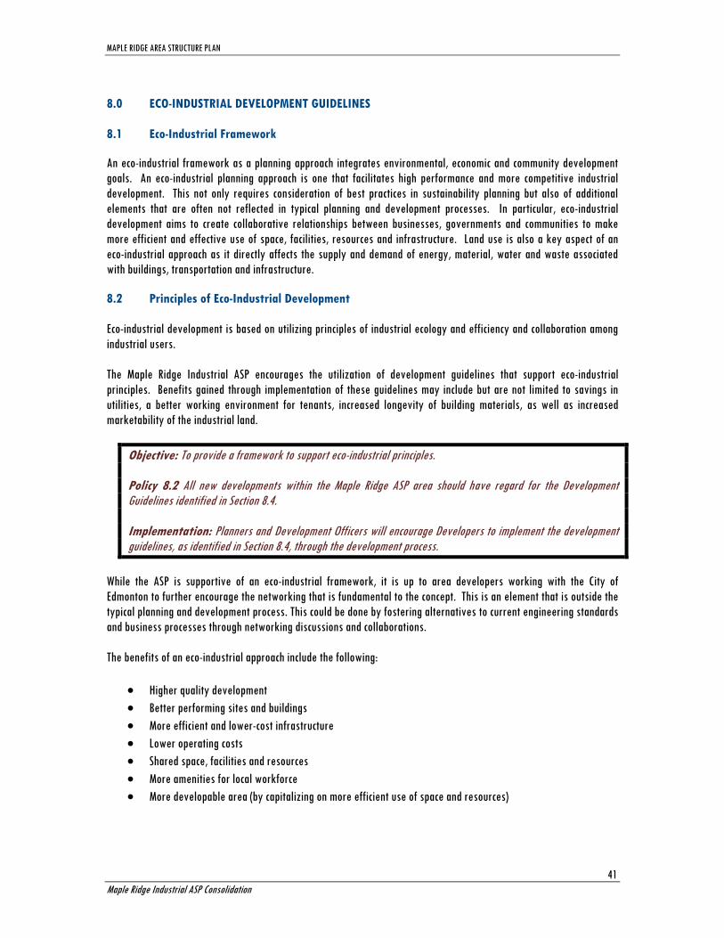
MAPLE RIDGE AREA STRUCTURE PLAN
Maple Ridge Industrial ASP Consolidation
41
8.0 ECO-INDUSTRIAL DEVELOPMENT GUIDELINES
8.1 Eco-Industrial Framework
An eco-industrial framework as a planning approach integrates environmental, economic and community development
goals. An eco-industrial planning approach is one that facilitates high performance and more competitive industrial
development. This not only requires consideration of best practices in sustainability planning but also of additional
elements that are often not reflected in typical planning and development processes. In particular, eco-industrial
development aims to create collaborative relationships between businesses, governments and communities to make
more efficient and effective use of space, facilities, resources and infrastructure. Land use is also a key aspect of an
eco-industrial approach as it directly affects the supply and demand of energy, material, water and waste associated
with buildings, transportation and infrastructure.
8.2 Principles of Eco-Industrial Development
Eco-industrial development is based on utilizing principles of industrial ecology and efficiency and collaboration among
industrial users.
The Maple Ridge Industrial ASP encourages the utilization of development guidelines that support eco-industrial
principles. Benefits gained through implementation of these guidelines may include but are not limited to savings in
utilities, a better working environment for tenants, increased longevity of building materials, as well as increased
marketability of the industrial land.
Objective: To provide a framework to support eco-industrial principles. Policy 8.2 All new developments within the Maple Ridge ASP area should have regard for the Development Guidelines identified in Section 8.4. Implementation: Planners and Development Officers will encourage Developers to implement the development guidelines, as identified in Section 8.4, through the development process.
While the ASP is supportive of an eco-industrial framework, it is up to area developers working with the City of
Edmonton to further encourage the networking that is fundamental to the concept. This is an element that is outside the
typical planning and development process. This could be done by fostering alternatives to current engineering standards
and business processes through networking discussions and collaborations.
The benefits of an eco-industrial approach include the following:
Higher quality development
Better performing sites and buildings
More efficient and lower-cost infrastructure
Lower operating costs
Shared space, facilities and resources
More amenities for local workforce
More developable area (by capitalizing on more efficient use of space and resources)

MAPLE RIDGE AREA STRUCTURE PLAN
Maple Ridge Industrial ASP Consolidation
42
8.3 Development Guideline Goals and Objectives
Goal: An eco-industrial approach supports opportunities to share spaces, facilities, resources and infrastructure in a
way that satisfies multiple objectives.
Objectives
To decrease capital and operating costs by sharing the use of facilities and related infrastructure between
businesses in the Plan area.
To identify and encourage the use of material outflows and by-products that can function as inputs in other
industries through pre-planning prior to development applications.
To provide a high quality environment for building occupants and site users.
To provide reduction in energy consumption and lower utility costs.
Goal: To enhance the sense of place of the Maple Ridge Industrial area each development will consider ways to protect
and highlight the natural context of the site.
Objectives
To reduce dependence on water-hungry planting
To include existing and native vegetation in the area
To minimize grading requirements
To use plants to infiltrate groundwater onsite.
To create a unique and appealing sense of identity that relates well to current development in the surrounding
area.
Goal: Attention should be paid to the way that vehicles, pedestrians, cyclists, and other users move around a site. This
promotes ease of use for employees and visitors of all types and therefore improves the functionality of the site. On-
site roadways and parking area pavement should be kept to a minimum to allow for natural groundwater infiltration in
a larger part of the Plan area.
Objectives
To improve the appearance and functionality of parking facilities.
To promote the ease of movement throughout the Plan area in all forms, pedestrian and automotive.
To minimize the paved surface in the Plan area.
Goal: Energy conservation can be integrated into individual sites at several levels. Each site and building should
consider using commercially available technologies to reduce their energy usage. This will provide benefits to the
environment, and will provide long term cost savings for developers and future businesses.
Objectives
To reduce energy use and maximize efficiency over the site through the use of available energy-saving
technology.
To promote alternatives to traditional energy production methods including various forms of on-site energy
production.
Goal: The water regime plays a large role in site development. Development typically changes the speed and quantity
of runoff drastically, which requires mitigation through the use of storm water ponds and pipes. However, this

MAPLE RIDGE AREA STRUCTURE PLAN
Maple Ridge Industrial ASP Consolidation
43
infrastructure does not provide for groundwater infiltration and informal natural filtration that occurs in a naturalized
storm water system.
Objectives
To utilize naturalized on-site storm water management techniques.
To increase the infiltration of storm water back into the groundwater table by decreasing paved surface area.
8.4 Development Guidelines
The development guidelines outlined have regard for ecology and efficiency, the residential component within the
industrial plan area, and collaboration among industrial users as part of site and building design. They help to achieve
the above noted goals and objectives that support eco-industrial development.
Ecology and Efficiency
Objective: To consider ecology and efficiency in site and building design by locating and constructing in a manner that minimizes energy use and by designing in a manner that mimics the natural processes of the environment. Guidelines: 8.4.1 Building design should take maximum advantage of natural lighting through strategic placement of windows and skylights. 8.4.2 Buildings should be oriented close to the front of the lot in order to reduce the distance for infrastructure extensions from municipal roadways. 8.4.3 Integrate an alternative on site energy source for the provision of the site’s total energy needs (i.e. geothermal systems, photovoltaic cells, a local co-generation facility, wind power, bio-mass, bio-gas.) 8.4.4 Incorporate grey water or captured rainwater for irrigation purposes. 8.4.5 Alternative roofing materials that improve environmental or building performance should be utilized (i.e. green roofs, reflective roofs.) 8.4.6 Integrate any existing wetland areas and drainage channels into the formal storm water management system. (NOTE: The use of existing wetlands for storm water management will require approvals under the Water
Act and the Environmental Protection and Enhancement Act.)
8.4.7 Minimize stormwater runoff through landscaping techniques (i.e. rain garden, small bio-ponds, dry-wells, integration of bio-swales within the landscaped setback.) 8.4.8 Porous surface materials should be utilized where possible and paved areas minimized. 8.4.9 Additional landscaping could be provided in parking lots to enhance appearance, reduce heat island effect and reduce runoff. 8.4.10 Landscape design should consider opportunities to connect to adjacent natural areas, parks or trails. 8.4.11 Site design should incorporate the existing nature vegetation where possible.

MAPLE RIDGE AREA STRUCTURE PLAN
Maple Ridge Industrial ASP Consolidation
44
8.4.12 Landscape design should utilize natural and/or drought-resistant vegetation to reduce irrigation needs and landscape maintenance. 8.4.13 Landscape design should utilize protection planting techniques for energy conservation (i.e. coniferous trees along the western face of buildings shelters them from prevailing winds; deciduous trees on the south side of buildings provides solar shading in summer and unobstructed sunlight in the winter.) 8.4.14 Parking and loading facilities should be located at the rear or side of the building to improve screening and maximize roadway frontage. 8.4.15 Preferential parking spaces should be available for carpoolers, small vehicles, and/or vehicles with low emissions and high gas mileage (i.e., hybrids) along with the provision of bicycle storage for staff and visitor use, and/or shower and locker facilities to support alternative commuting like cycling, rollerblading, or walking. (NOTE:
Bicycle parking must conform to the Zoning Bylaw.)
Sensitivity to Residential
Objective: Industrial development should be designed to allow for sensitive integration with adjacent residential development Guidelines: 8.4.16 Consider building design with increased aesthetic appeal, attention to façade articulation and building massing. 8.4.17 Dark-Sky Lighting should be used for all new development east of 17th Street to reduce the light pollution effect on surrounding residential areas. 8.4.18 Development signage should be designed to minimize the intrusion on residential development. 8.4.19 Industrial development should be separated from residential development through the use of a landscaped area.
Industrial User Collaboration
Objective: To support collaboration among industrial users to support sharing of facilities and efficient use of resources. Guidelines: 8.4.20 One common business facility may be shared by one or more adjacent business, such as a shared
communal waste collection area, shipping and receiving areas, parking, or outdoor lunch areas. 8.4.21 By-products and resources of one business may be shared by one or more additional business(es) which could increase efficiency and decrease waste.

MAPLE RIDGE AREA STRUCTURE PLAN
Maple Ridge Industrial ASP Consolidation
45
Appendix 1 – References
Bison Historical Services. (2007). Historical resources overview. Edmonton: Bison Historical Services.
City of Edmonton. (2002). Edmonton's industrial land strategy. Edmonton: City of Edmonton
City of Edmonton. (2006). Environmental strategic plan 2006. Edmonton: City of Edmonton.
City of Edmonton. (1985). Top - of - bank roadway policy: Edmonton: City of Edmonton.
City of Edmonton Planning and Development Department. (1990). Edmonton general municipal plan No. Bylaw 9076).
Edmonton: City of Edmonton.
City of Edmonton Planning and Development Department. (1998). Plan Edmonton: Edmonton's municipal development plan Bylaw No. 11777, as Amended). Edmonton: City of Edmonton.
City of Edmonton Planning and Development Department. (2007). Pylypow industrial neighbourhood area structure plan.
Edmonton: City of Edmonton.
City of Edmonton, Office of Infrastructure. (2004). Thinking outside the gap: Opportunities to address Edmonton’s infrastructure needs – infrastructure strategy report 2004. Edmonton: City of Edmonton.
City of Edmonton, Planning and Policy Services Branch, Planning and Development Department. (1985). North Saskatchewan river valley area redevelopment plan. Edmonton: City of Edmonton.
City of Edmonton, Asset Management and Public Works, & Drainage Services. (2005). Drainage services master plan 2004-2014 implementation strategies. Edmonton: City of Edmonton.
City of Edmonton, Drainage Services, & Asset Management and Public Works. (2006). Edmonton drainage services storm water quality strategy. Edmonton: City of Edmonton.
Deppe, Maile; Schlarb, Mary. Eco-industrial development workbook. Retrieved from:
http://www.usc.edu/schools/sppd/research/NCEID/EID%20Workbook_FINALFINALwD_1.pdf
Kathol, C. P., & McPherson, R. A. (1975). Urban geology of Edmonton (Bulletin No. 32). Edmonton: Alberta Research
Council.
Province of Alberta. (2004). Municipal government act. Edmonton: Alberta Queen's Printer.
Province of Alberta. Water act. Edmonton: Alberta Queen's Printer.
Spencer Environmental Management Services Ltd. (2007). Biophysical network analysis of maple ridge: Interim recommendations report. Edmonton: Spencer Environmental.
Stantec Consulting Ltd. (2005). Erosion and sedimentation control guidelines. Edmonton: City of Edmonton.
Subdivision Authority. (2003). Subdivision authority directive. planning for the interface of pipeline right-of-ways and the subdivision and development of land (Bylaw No. 11135). Edmonton: City of Edmonton